Greenland from Archaean to Quaternary Descriptive text to the Geological map of Greenland, 1:
|
|
|
- Bryce Adams
- 5 years ago
- Views:
Transcription
1
2 GEOLOGY OF GREENLAND SURVEY BULLETIN Greenland from Archaean to Quaternary Descriptive text to the Geological map of Greenland, 1: Niels Henriksen, A.K. Higgins, Feiko Kalsbeek and T. Christopher R. Pulvertaft GEOLOGICAL SURVEY OF DENMARK AND GREENLAND MINISTRY OF ENVIRONMENT AND ENERGY
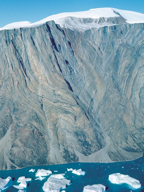
3 Geology of Greenland Survey Bulletin 185 Keywords Archaean, Caledonides, Cenozoic, economic geology, geological map, Greenland, ice sheet, Mesozoic, offshore, orogenic belts, Palaeozoic, petroleum, Phanerozoic, Proterozoic, sedimentary basins. Cover illustration The cover design depicts mountains of the East Greenland Caledonian fold belt. The view, west of Mestersvig (located on map, page 4), is north over Bersærkerbræ and the northern part of the Stauning Alper to Kong Oscar Fjord with Traill Ø in the right background. The mountains up to 1800 m high are of the late Proterozoic Eleonore Bay Supergroup. The person shown is senior author Niels Henriksen, daily leader of geological mapping, and participant in field work in Greenland for more than 45 years. He retired in Frontispiece: facing page Major Caledonian syncline deforming reactivated Archaean basement gneisses containing amphibolite bands. Overlying rusty coloured middle Proterozoic metasediments (Krummedal supracrustal sequence) just visible in tight core of the fold. The intensity of deformation in the syncline clearly increases towards the core, where the basement gneisses become more strongly foliated. Some of the amphibolite bands were derived from cross-cutting basic intrusions, which are still discernable in the less severely deformed parts of the Archaean basement (Fig. 15, p. 24). The height of the section is c m. South-west of innermost Nordvestfjord / Kangersik Kiatteq (c N), Scoresby Sund region, central East Greenland. Niels Henriksen, A.K. Higgins, Feiko Kalsbeek and T. Christopher R. Pulvertaft Geological Survey of Denmark and Greenland, Thoravej 8, DK-2400 Copenhagen NV, Denmark Chief editor of this series: Peter R. Dawes Scientific editor: W. Stuart Watt Publishing editor: Peter R. Dawes Editorial secretaries: Esben W. Glendal and Birgit Eriksen External referees: John A. Korstgård (Denmark) and Hans P. Trettin (Canada) Drawing work: Helle Zetterwall and Lis Duegaard Photographic reproduction: Benny M. Schark Lay-out and graphic production: Carsten E. Thuesen Printers: From & Co. A/S, Copenhagen, Denmark Manuscript submitted: 30th April, 1998 Final version approved: 8th July, 1999 Printed: 29th December, 2000 ISBN ISSN Geology of Greenland Survey Bulletin The series Geology of Greenland Survey Bulletin is a continuation of Bulletin Grønlands Geologiske Undersøgelse and incorporates Rapport Grønlands Geologiske Undersøgelse. Citation of the name of this series It is recommended that the name of this series is cited in full, viz. Geology of Greenland Survey Bulletin. If abbreviation of this volume is necessary the following form is suggested: Geology Greenland Surv. Bull. 185, 93 pp. Available from Geological Survey of Denmark and Greenland Thoravej 8, DK-2400 Copenhagen NV, Denmark Phone: , fax: , geus@geus.dk, homepage: or Geografforlaget ApS Fruerhøjvej 43, DK-5464 Brenderup, Denmark Phone: , fax: , go@geografforlaget.dk Danmarks og Grønlands Geologiske Undersøgelse (GEUS), 2000
4
5 Ellesmere Island Canada Pituffik / Thule Air Base Melville Bugt Upernavik Svartenhuk Halvø Disko Disko Bugt Aasiaat Sisimiut Nares Strait Peary Land western central eastern North North - West cent ral West Kangerlussuaq Arctic Ocean Inland Ice North - East central East southern East Station Nord Blosseville Kyst Daneborg 72 Mestersvig Scoresby Sund 68 Geographical subdivisions of Greenland used by the Survey Map showing the Survey s geographical subdivisions of Greenland, both onshore and offshore, used in this bulletin. Thus Nares Strait, the seaway separating Greenland from Ellesmere Island, Canada, borders North-West Greenland and western North Greenland. However, the strict application of all subdivisions is in places avoided in describing regional geology in order to avoid unwieldy phrases. It should also be noted that the names West Greenland and East Greenland are used in two ways: in the sense as shown on the map (each with two subdivisions, viz. central and southern) and for the entire western and eastern sides of Greenland, respectively. In this broader sense, West Greenland covers the four western subdivisions, viz. North-West, central West, southern West and South-West Greenland whereas East Greenland covers the four eastern subdivisions, viz. North-East, central East, southern East and South-East Greenland. The subdivisions are used throughout the text and also in the Legend explanation (pp ) and Index (pp ). Nuuk southern West South - East Tasiilaq / Ammassalik Iceland South - West Ivittuut Qaqortoq South 44 Kap Farvel North Atlantic Ocean km Editorial note As mentioned in the Preface, this bulletin contains an extensive reference list designed as a key to the most relevant sources to the explanation of the Geological map of Greenland 1: (printed in 1995). The main text with reference list was compiled in Text revisions during 1999 included references to publications that were in press in Subsequent additions in proof have been limited to results particularly relevant to the documentation and interpretation of the geology as presented on the map. No references to publications from 2000 have been included. For an update and listing of geoscientific Greenland literature published in 2000 the reader is referred to Review of Greenland activities 2000, to be published as Geology of Greenland Survey Bulletin
6 Contents Abstract Preface Introduction Concept of the geological legend Topographic base Crystalline rocks older than 1600 Ma: the Greenland Precambrian shield Archaean craton Early Archaean supracrustal rocks Early Archaean Amîtsoq gneisses Late Archaean supracrustal rocks Anorthositic rocks Late Archaean gneisses Intrusive rocks Proterozoic orogenic belts Nagssugtoqidian mobile belt Supracrustal rocks Felsic and intermediate intrusions Ammassalik mobile belt Early Proterozoic plutonic rocks Rinkian mobile belt Gneisses and intrusions Supracrustal rocks: Disko Bugt Supracrustal rocks: the Karrat Group North-West Greenland and Inglefield mobile belt Ketilidian mobile belt Early Proterozoic supracrustal rocks Early Proterozoic granitoids and basic intermediate intrusions Archaean early Proterozoic basement in the East Greenland Caledonian fold belt Archaean early Proterozoic basement beneath the Inland Ice Proterozoic to Phanerozoic geological development after formation of the Precambrian shield Early middle Proterozoic unfolded units Independence Fjord Group, North Greenland Zig-Zag Dal Basalt Formation, North Greenland Gardar Province, South Greenland Middle Proterozoic orogenic units reworked in the East Greenland Caledonian fold belt Supracrustal rocks Migmatites and granites Middle late Proterozoic sedimentary basin in North-West Greenland and Ellesmere Island Thule Supergroup Late Proterozoic sedimentary basins in North, North East and East Greenland..... Hagen Fjord Group, North Greenland Eleonore Bay Supergroup, East and North-East Greenland Tillite Group, East Greenland Sediments of unknown age in the East Greenland Caledonides Carbonatite complexes in Archaean gneisses of West Greenland The Palaeozoic Franklinian Basin of North Greenland and Ellesmere Island Cambrian Silurian in North Greenland Proterozoic Silurian exotic terrane of Ellesmere Island (Pearya) Ellesmerian orogeny in North Greenland and Ellesmere Island Lower Palaeozoic of East Greenland Cambrian Ordovician sediments in the Caledonian fold belt Caledonian orogeny in East and North-East Greenland
7 Caledonian intrusions and plutonic rocks Devonian continental sediments in East Greenland Carboniferous Tertiary deposits of the Wandel Sea Basin, central and eastern North Greenland Late Palaeozoic and Mesozoic rift basins in East Greenland Late Permian Early Cretaceous deposits of the Jameson Land Basin (70 72 N). Late Permian Cretaceous sediments in North-East Greenland (72 76 N)..... Cretaceous Tertiary sediments Central West Greenland Southern East Greenland Tertiary volcanics, intrusions and post-basaltic sediments Tertiary basalts, central West Greenland Tertiary basalts, East Greenland Blosseville Kyst region (68 70 N) Hold with Hope to Shannon region (73 75 N) Tertiary intrusions, East Greenland Post-basaltic Tertiary sediments, East Greenland Pliocene Pleistocene sediments, central North Greenland Quaternary glacial sediments Glaciology Mass balance Past climate and environment Offshore geology The continental margin off East and North Greenland The continental margin off West Greenland Offshore sedimentary basins North-East Greenland shelf (72 80 N) Liverpool Land Basin, central East Greenland (70 72 N) Blosseville Kyst Basin, East Greenland (67 70 N) Southern West Greenland (60 68 N) Central West Greenland (68 73 N) North-West Greenland (73 77 N) Mineral deposits Precambrian crystalline shield Middle Proterozoic intracratonic deposits Palaeozoic orogenic belts Upper Palaeozoic Mesozoic sediments Late Phanerozoic magmatic rocks Petroleum potential of Greenland Onshore basins Franklinian Basin, North Greenland (80 83 N) Late Palaeozoic Mesozoic rift basins, North-East Greenland (72 76 N) Jameson Land Basin, central East Greenland ( N) Cretaceous Tertiary basin, central West Greenland (69 72 N) Offshore basins North-East Greenland shelf (75 80 N) Liverpool Land Basin, central East Greenland (70 72 N) Blosseville Kyst Basin, East Greenland (67 70 N) Southern West Greenland (c N) North-West Greenland (73 77 N) Sedimentary basins concealed by volcanic rocks Acknowledgements References Legend explanation Place names register Index Geological map of Greenland, 1: in pocket 6
8 Abstract Henriksen, N., Higgins, A.K., Kalsbeek, F. & Pulvertaft, T.C.R. 2000: Greenland from Archaean to Quaternary. Descriptive text to the Geological map of Greenland, 1: Geology of Greenland Survey Bulletin 185, 93 pp. + map. The geological development of Greenland spans a period of nearly 4 Ga, from the earliest Archaean to the Quaternary. Greenland is the largest island in the world with a total area of km 2, but only c km 2 are exposed bedrock, the remaining part being covered by an inland ice cap reaching over 3 km in thickness. The adjacent offshore areas underlain by continental crust have an area of c km 2. Greenland is dominated by crystalline rocks of the Precambrian shield, which formed during a succession of Archaean and early Proterozoic orogenic events and which stabilised as a part of the Laurentian shield about 1600 Ma ago. The shield area can be divided into three distinct types of basement provinces: (1) Archaean rocks ( Ma old, with local older units) almost unaffected by Proterozoic or later orogenic activity; (2) Archaean terraines reworked during the early Proterozoic around 1850 Ma ago; and (3) terraines mainly composed of juvenile early Proterozoic rocks ( Ma old). Subsequent geological developments mainly took place along the margins of the shield. During the later Proterozoic and throughout the Phanerozoic major sedimentary basins formed, notably in North and North-East Greenland, and in places accumulated sedimentary successions which reached km in thickness. Palaeozoic orogenic activity affected parts of these successions in the Ellesmerian fold belt of North Greenland and the East Greenland Caledonides; the latter also incorporates reworked Precambrian crystalline basement complexes. Late Palaeozoic and Mesozoic sedimentary basins developed along the continent ocean margins in North, East and West Greenland and are now preserved both onshore and offshore. Their development was closely related to continental break-up with formation of rift basins. Initial rifting in East Greenland in latest Devonian to earliest Carboniferous time and succeeding phases culminated with the opening of the North Atlantic in the late Paleocene. Sea-floor spreading was accompanied by extrusion of Tertiary plateau basalts in both central West and central and southern East Greenland. During the Quaternary Greenland was almost completely covered by ice sheets, and the present Inland Ice is a relic of the Pleistocene ice ages. Vast amounts of glacially eroded detritus were deposited on the continental shelves offshore Greenland. Mineral exploitation in Greenland has so far mainly been limited to one cryolite mine, two lead-zinc deposits and one coal deposit. Current prospecting activities in Greenland are concentrated on the gold, diamond and lead-zinc potential. The hydrocarbon potential is confined to the major Phanerozoic sedimentary basins, notably the large basins offshore East and West Greenland. While proven reserves of oil or gas have yet to be found, geophysical data combined with extrapolations from onshore studies have revealed a considerable potential for offshore oil and gas. Authors' address Geological Survey of Denmark and Greenland, Thoravej 8, DK-2400 Copenhagen NV, Denmark. N.H. s present address: Birkevej 9, 3460 Birkerød, Denmark. 7
9 Fig. 1. Index map of the Geological map of Greenland, 1: , showing segments 2 13, so numbered in the atlas version of the map (for atlas format, see p. 9). Segment 1 the title page of the atlas is not shown. 8
10 Preface Greenland is the largest island in the world with a surface area of more than two million square kilometres. It is up to 1250 km from east to west and 2675 km from north to south, extending over almost 24 degrees of latitude; the northern extremity is the northernmost land area in the world. The Inland Ice, the large central ice sheet which covers c. 80% of Greenland, has a maximum thickness of c. 3.4 km. The ice-free strip of land surrounding the Inland Ice, in places up to 300 km wide, has an area of c km 2 ; this is approximately 30% more than that of the British Isles. This icefree zone is generally very well exposed and yields a wealth of geological information, notably in fjord walls and in mountainous areas; lowland areas have only a limited vegetation cover due to the arctic setting. The area of Greenland s offshore economic zone that is underlain by continental crust is estimated to be approximately km 2. Geological observations in Greenland began with the first scientific expeditions; these reached West and East Greenland in the early 1800s and North Greenland in the late 1800s and early 1900s. Systematic geological mapping commenced in East Greenland with Lauge Koch s Danish expeditions to East Greenland, which lasted from 1926 until 1958 and were mainly concentrated in the region N. In West Greenland systematic geological investigations began in 1946 with the foundation of Grønlands Geologiske Undersøgelse (GGU the Geological Survey of Greenland); work was initially concentrated in West Greenland but was subsequently extended to all parts of Greenland. Comprehensive investigations by GGU expanded to include not only geological mapping, but a wide range of geochemical, geophysical and glaciological studies both onshore and offshore. In 1995 GGU was merged with Danmarks Geologiske Undersøgelse (DGU the Geological Survey of Denmark) to form a new institute, Danmarks og Grønlands Geologiske Undersøgelse (GEUS the Geological Survey of Denmark and Greenland). The broad range of geological activities in Greenland previously undertaken by GGU continue to be carried out by GEUS. When GGU published the first general geological map of all of Greenland at scale 1: in 1970, representation of the geology was restricted to onshore areas; relatively little was then known of the offshore geology. During the past 25 years the offshore areas surrounding Greenland have been investigated by airborne and shipborne geophysical surveys operated by the Survey, other scientific institutions and commercial companies, notably in connection with oil exploration activities. Sufficient is now known to enable an interpretation of the offshore geology to be presented on the new map, although it is emphasised that for some of the remote areas offshore North Greenland knowledge remains sketchy. There is considerable petroleum exploration interest in many of the offshore sedimentary basins, and geological knowledge of the offshore areas is expected to be considerably augmented in the near future as a result of commercial exploration. The new Geological map of Greenland, 1: , printed in 1995, is available in three formats: 1. A wall map (sheet size 96 x 120 cm). 2. A folded map sheet (24 x 20 cm, as in pocket of this bulletin). 3. An atlas of numbered segments (24 x 20 cm when closed). Fig. 1 is an index to 12 numbered segments of the map. The description of the map has been prepared with the needs of the professional geologist in mind; it requires a knowledge of geological principles but not previous knowledge of Greenland geology. Throughout the text reference is made to the key numbers in the map legend indicated in square brackets [ ] representing geological units (see Legend explanation, p. 79), while a Place names register (p. 83) and an Index (p. 87) include place names, geological topics, stratigraphic terms and units found in the legend. The extensive reference list is intended as a key to the most relevant information sources. The text has been compiled by N. Henriksen. Principal contributors include: N. Henriksen (several sections and illustrations); A.K. Higgins (Lower Palaeozoic in North Greenland); F. Kalsbeek (Precambrian shield); T.C.R. Pulvertaft (offshore geology and petroleum potential). In addition, information and drafts for various sections were provided by colleagues (see Acknowledgements, p. 67). 9
11 Introduction A general overview of the geology of the whole of Greenland in the form of a coloured map sheet, the Tectonic/geological map of Greenland, was published by the Geological Survey of Greenland (GGU) in 1970 at a scale of 1: Subsequently, a wealth of new information has become available as a result of new systematic geological mapping in the ice-free land areas, notably in North, North-East and South-East Greenland, while offshore areas have been investigated by a series of seismic, gravimetric and aeromagnetic surveys. The Inland Ice has also been intensely studied over the past 25 years, by regional satellite and airborne radar surveys as well as by ground studies and deep drilling through the more than 3000 m thick central part of the ice sheet. As a consequence of these developments the new Geological map of Greenland, 1: , includes not only an up-to-date interpretation of the ice-free land areas, but as a new element summarises current knowledge of the geology of the offshore regions around Greenland. For the Inland Ice completely new representations of the upper and lower surface of the ice sheet are shown by contours, together with its calculated thickness. To relate the geology of Greenland to neighbouring countries within the borders of the map sheet, the geology of the adjacent areas of Canada and Iceland has been included, based on recent published maps (see map legend). The geology of the ice-free land areas on the new 1: map has been compiled as a conventional bedrock geological map, together with representations of the major tectonic features in the orogenic belts. The presentation of the geology of offshore areas follows a different concept, as interpretations are based on geophysical information. Onshore superficial deposits of Quaternary age have been shown only where extensive areas of bedrock are covered. In many regions dykes are a prominent element of the geology, but as they form only a minor proportion of the exposures they cannot generally be represented at the scale of the map. A compilation of dykes of different ages is shown in this volume as Fig. 18. The Inland Ice and the many local ice caps and glaciers are shown as one unit. The sea ice which covers substantial parts of the oceans bordering North and East Greenland for much of the year, is not depicted on the map. The term Tertiary and division of the Proterozoic into early, middle and late, have been retained in the text in order to be consistent with the map, which was published before the new conventions of Palaeogene/Neogene and Palaeo-, Meso- and Neoproterozoic were established. In the Precambrian descriptions the prefixes early, middle and late have generally been used for subdivisions of both Archaean and Proterozoic time and rock units. Concept of the geological legend Two different legend concepts have been used one for the onshore ice-free areas and one for the offshore regions. In the legend for the ice-free land areas a distinction has been made between rocks older and younger than 1600 Ma. In the older group, which mainly comprises crystalline rocks of the stable Precambrian Greenland shield, the rock units are distinguished according to their lithology and age; the extent of regional tectonometamorphic provinces is also depicted. Rocks younger than 1600 Ma are shown in relation to the formation of sedimentary basins and orogenic belts along the margins of the stable shield. The principal subdivisions depicted on the map illustrate the general depositional environment, age and extent of the main sedimentary and volcanic basins and, in the Franklinian Basin in North Greenland, the overall depositional setting. Younger crystalline gneisses and plutonic rocks are distinguished by lithology and age of orogenic formation and emplacement. A schematic chronological representation of the geological units shown on the map is included in the map legend. The structures and the age of deformation in the various orogenic belts are shown by structural trend lines and major tectonic features by appropriate symbols. Most orogenic belts are of composite origin and may incorporate older crystalline rocks and structures. It is often difficult, or impossible, to distinguish between the older and younger structural elements, and therefore only the signature for the youngest orogenic event has been used within a specific fold belt. Post-orogenic undeformed rocks can be recognised by the absence of overprints of structural symbols. 10
12 A schematic cartoon representation of the crustal evolution of Greenland is incorporated in the legend. Six stages of evolution are shown from the early Archaean to the Tertiary. These show the distribution in time and space of the orogenic belts and the stepwise growth of the stable crust. The post-orogenic development of sedimentary basins and volcanic provinces is also shown, together with the approximate extent of continental crust around Greenland. The legend concept for the offshore areas is based on geological interpretation of the available geophysical data. Distinction is made between areas underlain by continental crust and areas underlain by oceanic crust; a transition zone is also recognised. Areas with oceanic crust are further subdivided into time slices of 15 Ma based on magnetic anomaly patterns. Magnetic anomaly lines with chron-numbers are shown, together with spreading axes and transform faults. Major sedimentary basins are indicated by isopachs showing the sediment thickness superimposed on a representation of crustal type. Volcanic rocks exposed on the seabed (mostly Tertiary in age) are also shown. Topographic base The topographic base for the new 1: geological map is completely new and it has been drawn on the basis of fixed points established throughout Greenland by Kort & Matrikelstyrelsen, Denmark (KMS the National Survey and Cadastre, which incorporates the former Geodetic Institute). The map is constructed as a UTM projection in zone 24 with WGS 84 datum; the central meridian is 39 W. Photogrammetric constructions by KMS and GGU have been combined and co-ordinated to produce the first geometrically correct topographic representation of all of Greenland. All previous maps have suffered to varying degrees from insufficient ground control, especially in North Greenland where errors in the location of topographic features of up to 25 km occur on earlier maps (Fig. 2). Height contours have been omitted on the ice-free land areas to avoid obscuring the geological detail, but they are shown on the Inland Ice. Place names are indicated in both their Greenlandic and Danish form, the Greenlandic names with the new orthography as approved by the Greenland Place Names Authority. A register of place names used on the map is given at the end of this work. The bathymetry of the offshore areas has been compiled from various sources. The available material is very heterogeneous, ranging from very detailed navigation maps by the Royal Danish Hydrographic Office (now part of KMS) to generalised small-scale international oceanographic maps. Information from the ice-covered regions off North and East Greenland is limited; hydro km Canada I n l a n d I c e G R E E N L A N D 30 Fig. 2. Outline map of North Greenland showing misplacement of boundaries between land and sea on respectively old (black) and new (red) topographic maps. The new map outline in red is based on ground control points measured in Data from Kort & Matrikelstyrelsen, Copenhagen, Denmark. 11
13 graphic representations from these areas should therefore be viewed with reservation. A new topographical map of Greenland at a scale of 1: was published by KMS in 1994 (KMS 1994). The new Geological map of Greenland at the same scale uses an identical topographic base map with the same projection; the only significant topographical difference is the omission of contour lines on the land areas. Based on the digital data for the new topographic map, the size of Greenland and its ice cover has been computed by Weng (1995). The new area figures are: Ice-free land area km 2 Ice-covered area km 2 Total area km 2 Crystalline rocks older than 1600 Ma: the Greenland Precambrian shield Upernavik Uummannaq Inglefield mobile belt Rinkian mobile belt Inland Ice Caledonian fold belt About half of the ice-free area of Greenland consists of Archaean and early Proterozoic crystalline basement rocks, mainly orthogneisses with some enclaves of supracrustal rocks. They belong to three distinct types of basement province (Fig. 3): (1) Archaean rocks ( Ma old, with local older units), almost unaffected by Proterozoic or later orogenic activity; (2) Archaean terraines reworked during the early Proterozoic around 1850 Ma ago; (3) terraines mainly composed of juvenile early Proterozoic rocks ( Ma old). Terranes of categories (2) and (3) often contain high grade early Proterozoic metasedimentary successions. Nearly all unreworked Archaean gneisses occur within the Archaean craton of southern Greenland (Fig. 3). They are cut by swarms of basic dykes (see Fig. 18), most of which belong to a c Ma suite; the Disko Bugt Nuuk / Godthåb Nagssugtoqidian mobile belt Isukasia Archaean craton Ketilidian mobile belt Ammassalik mobile belt 400 km Fig. 3. Simplified map showing the distribution of Archaean and early Proterozoic basement provinces in Greenland. Orange: preserved Archaean (southern Greenland). Yellow: Archaean rocks reworked during the early Proterozoic (areas dominated by early Proterozoic metasediments are dotted). Pink: Dominantly juvenile early Proterozoic rocks. White: Younger formations and ice. Large Dots and open circles indicate schematically localities where the presence of, respectively, Archaean and early Proterozoic rocks have been documented in poorly known areas, and in cases where these ages are in contrast to the age of the surrounding rocks. Slightly modified from Kalsbeek (1994). 12

14 dykes are undeformed and unmetamorphosed, so the gneisses of the Archaean craton cut by the dykes cannot have been significantly affected by early Proterozoic orogenic activity around 1850 Ma ago. Reworked Archaean gneisses are prominent in the Nagssugtoqidian and Rinkian mobile belts that occur north of the Archaean craton in West Greenland, and in the Ammassalik mobile belt of East Greenland (Fig. 3). Juvenile early Proterozoic gneisses and granitoid rocks ( Ma) make up most of the Ketilidian mobile belt of South Greenland, and they also form a large proportion of the crystalline basement within the Caledonian fold belt of North-East Greenland; they are also present in the Inglefield mobile belt in North-West Greenland. Before the opening of the Labrador Sea and Baffin Bugt the Precambrian basement of Greenland formed an integral part of the Laurentian Shield, and correlations between tectonic units in Canada and Greenland have been proposed (e.g. Hoffman 1989, 1990). However, the pre-drift fit of Greenland to Canada is still not accurately known and correlations are thus rarely straightforward; a detailed discussion of these relationships is outside the scope of this map sheet description. Archaean craton Most rocks of the Archaean craton (Kalsbeek & Garde 1989) were formed during the late Archaean Ma ago. Early Archaean gneisses and supracrustal rocks ( Ma old) have been found in the Godthåbsfjord region of South-West Greenland, where three distinct tectonic terranes have been recognised (Fig. 4). Each terrane has a characteristic rock association and tectonic history (Friend et al. 1987) and they were brought together by thrusting c Ma ago; they are separated by mylonite zones. It is likely that the Archaean craton elsewhere is also built up of distinct terranes, which may explain why gneisses and supracrustal rocks in different parts of the Archaean craton often have different ages. Finnefjeld 1 Taserssuaq? Isukasia Inland Ice 65 Fiskefjord Nordlandet Godthåbsfjord 2 Nuuk/Godthåb Ameralik 64 Færingehavn Tre Brødre 30 km Fig. 4. Map of the Godthåbsfjord region, southern West Greenland, showing different tectonic terranes (plates). 1: Akia terrane; 2: Akulleq terrane; 3: Tasiusarssuaq terrane. Modified from McGregor (1993). Fig. 5. Early Archaean banded iron formation comprising interbanded magnetite (dark coloured) and chert (light coloured). Isua supracrustal sequence, Isukasia, inner Godthåbsfjord, southern West Greenland. Pen for scale. Photo: A.A. Garde. 13
![Early Archaean supracrustal rocks The Isua supracrustal sequence [69] (3700 3800 Ma old, Moorbath et al.](/docs-images/92/108605791/images/15-0.jpg "1973), which occurs in the Isukasia area at the head of Godthåbsfjord (Nuup Kangerlua) in West Greenland (Fig. 4), is the most extensive occurrence of early Archaean supracrustal rocks known on earth.")
15 Early Archaean supracrustal rocks The Isua supracrustal sequence [69] ( Ma old, Moorbath et al. 1973), which occurs in the Isukasia area at the head of Godthåbsfjord (Nuup Kangerlua) in West Greenland (Fig. 4), is the most extensive occurrence of early Archaean supracrustal rocks known on earth. It forms a zone up to 4 km wide and up to c. 35 km long and has been investigated in considerable detail. A recent review of earlier studies together with new data is presented by Appel et al. (1998, see also Nutman 1986). The sequence contains: (1) Layered and massive amphibolites with Fe-rich tholeiitic compositions, within which pillow structures are locally preserved; (2) Metacherts and a major body of banded iron formation thought to have originated as chemical sediments (Fig. 5); (3) Biotite-muscovite schists, some of which preserve graded bedding; (4) Units of talc schist, up to 100 m wide, with relics of dunite; (5) Banded carbonate and calc-silicate rocks, probably metasomatic in origin; (6) Bodies of chloritic leuco-amphibolite (garbenschiefer) up to 1 km wide which form c. 25% of the supracrustal belt and probably represent metasomatically altered metavolcanic rocks. All these rocks are strongly deformed and at high metamorphic grade, and the nature of their protoliths as well as their precise ages are under continuous debate. Recent investigations have shown that the Isua supracrustal belt consists of at least two temporally distinct and unrelated sequences of supracrustal rocks, one about 3710 Ma and the other probably around 3800 Ma old, separated by thrusts (Nutman et al. 1997). Parts of the belt were isoclinally folded before intrusion of 3750 Ma old tonalites, while the arcuate trend of the belt as a whole is the result of at least two phases of later deformation (Nutman 1986). Outside the Isukasia area inclusions of supracrustal rocks, mainly amphibolites of tholeiitic or komatiitic composition, occur within early Archaean gneisses as thin units. These supracrustal rocks have been collectively termed the Akilia association [69], and are thought to represent fragments of a disrupted greenstone belt (McGregor & Mason 1977). Studies of graphite particles in samples of Isua and Akilia metasedimentary rocks have yielded evidence of very early life on earth (Mojzsis et al. 1996; Rosing 1999). Fig. 6. Heterogeneous, polyphase Amîtsoq gneiss in the central part of northern Godthåbsfjord, southern West Greenland. Fragments of dark homogeneous amphibolite are interpreted as remnants of disrupted Ameralik dykes. The hammer is c. 45 cm long. Photo: A.A. Garde. 14
16 Early Archaean Amîtsoq gneisses The early Archaean Amîtsoq gneisses [76] (Fig. 6) occur in an area stretching north-east from Nuuk/Godthåb to Isukasia. They are characterised by the presence of abundant remnants of metamorphosed basic dykes, known as the Ameralik dykes (see Fig. 18; McGregor 1973). The gneisses were formed during a number of distinct intrusive events that occurred between 3900 and 3600 Ma ago (Moorbath et al. 1972; Nutman et al. 1993). Two main types of Amîtsoq gneiss can be recognised: (1) Grey, layered to homogeneous tonalitic to granitic orthogneisses of calc-alkaline affinity (commonly with secondary pegmatite banding) which form at least eighty per cent of the outcrop; (2) Microcline augen gneisses with associated subordinate ferrodiorites (c Ma old), which have been referred to as the Amîtsoq iron-rich suite (Nutman et al. 1984). The latter resemble Proterozoic rapakivi granites and were intruded after the strong deformation in the surrounding grey banded gneisses. Most Amîtsoq gneisses are in amphibolite facies, but locally the rocks have been affected by a c Ma old granulite facies metamorphism possibly related to emplacement of the Amîtsoq iron-rich suite. Late Archaean supracrustal rocks Ten to twenty per cent of the Archaean craton is made up of a variety of supracrustal rocks [68], mainly amphibolites with subordinate paragneisses (often garnetiferous ± cordierite ± sillimanite) and ultramafic layers and pods. No reliable age determinations for these rocks are available, and they may belong to different age groups. Amphibolites locally show well-preserved pillow structures indicating a submarine volcanic origin. Intense deformation, however, has generally obliterated all primary structures and produced finely layered amphibolites. More massive amphibolites may represent original basic sills within the volcanic pile. Chemically the amphibolites range from low-k tholeiitic to komatiitic in composition. Major units of garnetiferous paragneisses occur only locally, for example in the northern part of the Archaean craton north of Maniitsoq/Sukkertoppen; while these may be younger than most of the late Archaean gneisses, they were intruded by younger Archaean granitoid sheets. The late Archaean evolution of the craton was evidently very complex. Supracrustal units are usually folded, and as they form good marker horizons they often reveal the intricate structure of the enveloping gneiss complexes. Primary cover basement relationships with earlier gneisses have not been observed. Anorthositic rocks Metamorphosed calcic anorthosites and associated leucogabbroic and gabbroic rocks [85] form one of the most distinctive rock associations in the Archaean craton. They occur as concordant layers and trains of inclusions, and provide some of the best marker horizons for mapping structures on a regional scale. Anorthositic rocks are generally bordered by amphibolite units into which they are believed to have been intruded. Anorthosites and associated rocks are most spectacularly developed in the Fiskenæsset area of West Greenland where they form c. 5% of the total outcrop. Here they appear to belong to a single stratiform intrusion, the Fiskenæsset complex (Myers 1985), which has been dated at c Ma (Ashwal et al. 1989). The main rock types are metamorphosed anorthosite (< 10% mafics), leucogabbro (10 35% mafics) and gabbro (35 65% mafics), together with minor amounts of ultramafic rocks and chromitite. Magmatic structures are often preserved: cumulus textures with plagioclase up to 10 cm in size are common and igneous layering can be observed at many localities. The Fiskenæsset complex has undergone complex folding. The earliest major folds were recumbent isoclines; these were refolded by two later fold phases producing structures with steeply inclined axial surfaces (Myers 1985). Late Archaean gneisses Most of the Archaean craton is composed of grey orthogneisses [72, 73] which were mainly generated Ma ago. In the Nuuk/Godthåb region of West Greenland they are up to 3100 Ma old, whereas in the Fiskenæsset area to the south isotopic ages are generally less than 2900 Ma. It is believed that the precursors of the gneisses were intruded as sub-concordant sheets and larger complexes that penetrated and disrupted ( exploded ) pre-existing basic volcanic units and anorthositic rocks; the gneisses commonly occupy much larger volumes than the older rocks into which they were intruded. Individual gneiss sheets range from 15
. Commonly the gneisses show complex fold interference structures (e.g. Berthelsen 1960; Fig. 8).")
17 whereas in the gneisses its presence depends on chemical composition; parts of the amphibolite facies gneisses in the northern part of the craton were formed by retrogression of granulite facies rocks (e.g. Garde 1990). Commonly the gneisses show complex fold interference structures (e.g. Berthelsen 1960; Fig. 8). Formation of the gneisses by deformation and migmatisation of their igneous precursors has been described in detail by Myers (1978), and a detailed description of the complex evolution of the Fiskefjord area, north of Godthåbsfjord, was recently presented by Garde (1997). Fig. 7. Amphibolite agmatite with numerous sheets of tonalite, granodiorite, granite and pegmatite, dated at Ga. Southfacing, c. 40 m high cliff in central Godthåbsfjord, southern West Greenland. Person in red anorak for scale. Photo: A.A. Garde. a few metres to several kilometres in thickness (Fig. 7). It has been suggested that intrusion of granitoid magma took place during periods of thrusting (Bridgwater et al. 1974). Most of the gneisses are tonalitic to granodioritic in composition. In the Fiskenæsset area gneisses form c. 85% of the outcrop with tonalitic gneisses as the dominant component. In amphibolite facies gneisses biotite is the most important ferromagnesian mineral. About half of the craton north of Fiskenæsset is occupied by granulite facies gneisses [73]. Granulite facies metamorphism, however, was not synchronous throughout the area: north of Nuuk/Godthåb it is Ma old (Garde 1990; Friend & Nutman 1994), whereas in the Fiskenæsset area it is c Ma old (Pidgeon & Kalsbeek 1978) and north of Maniitsoq/Sukkertoppen c Ma old (Friend & Nutman 1994). In granulite facies terraines hypersthene is most common in amphibolites, Intrusive rocks Within the late Archaean gneisses a variety of homogeneous granitic to tonalitic rock units have been differentiated on the map as felsic intrusions [80]. These rocks were emplaced at various times during the tectonic evolution of the areas in which they occur. Some (e.g. the c Ma old Taserssuaq tonalite north of inner Godthåbsfjord) represent late phases of the igneous precursors of the gneisses in areas where deformation was less intense than elsewhere. Others (e.g. the 2800 Ma old Ilivertalik augen granite north-east of Fiskenæsset) are younger than the surrounding gneisses, but have been strongly overprinted by later deformation. One rock unit, the 2550 Ma old Qôrqut granite complex [79] (Friend et al. 1985), is clearly post-tectonic. A distinct 2700 Ma old suite of very well-preserved post-tectonic intermediate and mafic intrusions, including gabbros and diorites [82] as well as syenites and granites [80], occurs within late Archaean gneisses in the Skjoldungen district of South-East Greenland (Nielsen & Rosing 1990; Blichert-Toft et al. 1995). It is associated with older syenitic gneisses [80] and with a late nephelinite body, the 2670 Ma old Singertât complex [83]. Small norite bodies [82] occur within an arcuate belt east of Maniitsoq/Sukkertoppen (Secher 1983), and a small carbonatite sheet c Ma old [84] has been found at Tupertalik, N in West Greenland (Larsen & Pedersen 1982; Larsen & Rex 1992). Proterozoic orogenic belts About forty per cent of the ice-free area of Greenland is underlain by early Proterozoic orogenic belts (Fig. 3). Several of these consist largely of reworked Archaean rocks that underwent strong deformation and metamorphism during early Proterozoic ( Hudsonian ) oro- 16
18 2 km Surface of an upper pyroxene-amphibolite unit Surface of a lower pyroxene-amphibolite unit Fig. 8. Structural stereogram of the western Toqqusap Nunaa area north of Atammik (c. 65 N), southern West Greenland, showing complex fold structures in the late Archaean gneiss complex. Slightly modified from Berthelsen (1960). genic events around 1850 Ma ago. Others are made up of juvenile early Proterozoic crust. Nagssugtoqidian mobile belt The Nagssugtoqidian mobile belt (Fig. 3; van Gool et al. 1996, 1999) extends from Søndre Strømfjord to Disko Bugt in West Greenland. It consists mainly of reworked Archaean gneisses [74, 75] but also includes early Proterozoic supracrustal and intrusive rocks [67, 78, 81]. Main structures trend ENE WSW. The peak of Proterozoic tectonic and metamorphic activity was at c Ma when large parts of the belt underwent granulite facies metamorphism. Early Proterozoic orogenic activity is believed to be related to collision of two Archaean continents, with a suture present within the Nagssugtoqidian mobile belt (Kalsbeek et al. 1987). Reworking of Archaean gneisses in the Nagssugtoqidian mobile belt was first recognised by Ramberg (1949); a swarm of basic dykes, the Kangâmiut dykes (2040 Ma, Nutman et al. 1999), which are well preserved in the Archaean craton to the south, become increasingly deformed and metamorphosed on entering the Nagssugtoqidian mobile belt (see Fig. 18). Supracrustal rocks Early Proterozoic supracrustal rocks are prominent in the central part of the Nagssugtoqidian mobile belt [67], and are dominated by pelitic and semipelitic metasediments. Marble and calc-silicate rocks are common within these metasedimentary units, and pelitic rocks may be rich in graphite. While the metasediments are cut by sheets of 1920 Ma quartz diorite, age determinations on detrital zircons (Nutman et al. 1999) show that deposition must have taken place later than c Ma. Within the Nagssugtoqidian mobile belt late Archaean metasediments [68] are also present, for example at the southern shore of Disko Bugt. They are not easily distinguished in the field from Proterozoic rocks, 17

19 and since isotopic age determinations are few, it is not certain that all supracrustal sequences shown on the map have been assigned to the correct age category. The involvement of early Proterozoic supracrustal rocks in complex fold structures and shear zones in the central part of the belt shows that the deformation was of Proterozoic age. Felsic and intermediate intrusions There are only a few granitic and quartz dioritic intrusive bodies in the Nagssugtoqidian mobile belt. Some are of Archaean origin [80], whereas others are of early Proterozoic age [78]. A large sheet of quartz diorite [81], dated at 1920 Ma, occurs close to the border of the Inland Ice at 68 N (Henderson 1969; Kalsbeek et al. 1987); it is folded and strongly deformed at its margins, but igneous textures and minerals are preserved in its centre. Strongly deformed Proterozoic quartz dioritic to tonalitic rocks (not shown on the map) also occur within reworked Archaean gneisses south of the main quartz diorite body, and have been interpreted as remnants of an early Proterozoic island arc tectonically interleaved with the Archaean rocks (Fig. 9; Kalsbeek et al. 1987; van Gool et al. 1999). A large area (c. 30 x 50 km) east and north-east of Sisimiut/Holsteinsborg is made up of early Proterozoic hypersthene gneisses (Kalsbeek & Nutman 1996). In the field these cannot easily be distinguished from Archaean rocks that occur farther east, and on the map all rocks in this region are shown as Archaean, overprinted by Proterozoic granulite facies metamorphism [75]. Ammassalik mobile belt The Ammassalik mobile belt extends from N to 68 N in southern East and South-East Greenland (Fig. 3), and is probably an extension of the Nagssugtoqidian belt of West Greenland. The belt is dominated by reworked Archaean gneisses [74, 75] which were tec- Fig. 9. Rock face at south side of inner Nordre Strømfjord/Nassuttooq, southern West Greenland, showing tectonic contact between pale Archaean tonalitic gneisses and overlying dark dioritic gneisses and supracrustal rocks of Proterozoic age. Thin slices of marble and calc-silicates occur at the contact and within the Archaean gneisses. The height of section is c. 350 m. Photo: J.A.M. van Gool. 18

20 Fig. 10. Ammassalik mobile belt. Archaean gneisses reworked during the early Proterozoic in granulite and retrograde granulite facies, with supracrustal layers consisting of amphibolites and paragneisses. East of northernmost Sermilik (c N), South-East Greenland. The prominent summit is 1750 m high; relief seen is c m. Photo: J.C. Escher. tonically interleaved with metasediments during the early Proterozoic (Fig. 10; Chadwick et al. 1989; Kalsbeek 1989). In the Ammassalik district early Proterozoic pelitic metasediments [67] are prominent, and locally contain abundant kyanite; thick marble units also occur. Archaean anorthositic rocks [85] are present in a few places. Early Proterozoic plutonic rocks A late tectonic suite (1885 Ma old) of leuconoritic and charnockitic intrusive rocks [81], the Ammassalik Intrusive Complex, occurs as a WNW ESE-trending series of intrusions at N (Friend & Nutman 1989). This suite was emplaced into gneisses and sediments, in which it caused widespread anatexis and produced a series of garnet-rich granitic gneisses [71]. Early Proterozoic quartz dioritic to tonalitic intrusions [81] occur locally; one is shown just north of latitude 66 N. Their age is not precisely known, but may be of the order of 2000 Ma. Early Proterozoic gneisses, formed locally by deformation of such intrusive rocks, are not distinguished on the map. Scattered post-tectonic granite plutons [78] associated with diorites and local gabbro occur over the central part of the Ammassalik mobile belt. Their isotopic age is about 1680 Ma, much later than the peak of tectonic and metamorphic activity in the belt which was between 1900 and 1800 Ma ago (Kalsbeek et al. 1993a). Isotopic data show that the granites are largely of crustal origin. Rinkian mobile belt The Rinkian mobile belt (Henderson & Pulvertaft 1987; Grocott & Pulvertaft 1990) lies to the north of the Nagssugtoqidian mobile belt in West Greenland between latitudes 69 N and 75 N (Fig. 3). The mobile belt is characterised by the presence of a distinctive early Proterozoic sedimentary succession several kilometres thick, the Karrat Group [62], which overlies reworked Archaean gneisses [74]. It has not been possible to define a natural boundary between the Nagssugtoqidian and Rinkian belts. Nearly everywhere north of the Archaean craton effects of Proterozoic deformation and metamorphism can be found. However, in the area east and north-east of Disko Bugt the Archaean rocks appear to have been less strongly affected by Proterozoic reworking than in the areas to the north and south (Garde & Steenfelt 1999). Gneisses and intrusions Reworked Archaean gneisses [74] in the Rinkian mobile belt are similar to those of the Archaean craton. On Nuussuaq, and farther north, they contain anorthosite bodies [85] and several dioritic intrusions [82]. North of Nuussuaq sheets of Archaean augen gneisses occur locally (not distinguished on the map) and have been used as structural markers to unravel the complex thrust tectonics of that area (Pulvertaft 1986). 19
21 2000 m Y Y Y Y Y Y Y Y Y Y Y Y Y Y Y Y Y Y Y Y Y Y Y Y Y Y Y Y Y Y Y Y Y Y Y Y Y Y Y Y Y Y Y Y Y Y Y Y Y Y Y Y Y Y Y Y Y Y Y Y Y Y Y Y Y Y Y Y Y Y Y Y Y Y Y Y Y Y Y Y Y Y Y Y Y Y Y Y Y Y Y Y Y Y Y Y Y Y Y Y Y Y Y Y Y Y Y Y Y Y Y Y Y Y Y Y Y Y Y Y Y Y Y Y Y Y Y Y Y Y Y Y Y Y Y Y Y Y Y Y Y Y Y Y Y Y Y Y Y Y Y Y Y Y Y Y Y Y Y Y Y Y Y Y Y Y Y Y Y Y Y Y Y Y Y Y Y Y Y Y Y Y Y Y Y Y Y Y Y Y Y Y Y Y Y Y Y Y Y Y Y Y Y Y Y Y Y Y Y Y Y Y Y Y Y Y Y Y Y Y Y Y Y Y Y Y Y Y Y Y Y Y Y Y Y Y Y Y Karrat Isfjord N Y Y Y Y Y Y Y Y Y Y Y Y Y Y Y Y Y Y Y Y Y Y Y Y Y Y Y Y Y Y Y Y Y Y Y Y Y Y Y Y Y Y Y Y Y Y Y Y Y Y Y Y Y Y Qeqertarssuaq Fm Nûkavsak Fm Y Y Y Y Y Y Y Y Y Y Y Y Y Y Y Y Y Y Y Y Y Y Y Y North-east of Disko Bugt/Qeqertarsuup Tunua a well preserved 2800 Ma old tonalitic intrusive complex [80] shows few signs of Proterozoic deformation. It was emplaced into a late Archaean greenstone belt [68] and earlier gneisses (Kalsbeek & Skjernaa 1999). The 1860 ± 25 Ma old Prøven charnockite [78] (Kalsbeek 1981) in the Upernavik area (c N) consists of charnockites and leucogranitic rocks. It was emplaced into Archaean gneisses and early Proterozoic metasediments (the Karrat Group), which are here of granulite facies metamorphic grade. There may be a connection between emplacement of the Prøven charnockite and the high-grade metamorphism. Y Y YY YY Y YY Marble Dolomite Amphibolite Pelite Semipelite Quartzite Basement Maarmorilik N Fig. 11. Schematic lithostratigraphic sections of the lower Proterozoic Karrat Group in the Maarmorilik Karrat Isfjord region. The Nûkavsak Formation consists of a flysch succession of interbedded greywacke and mudstone, now metamorphosed in amphibolite facies. Based on Garde (1978) and Henderson & Pulvertaft (1987). YY YY Y Y YY Y Y Mârmorilik Fm Supracrustal rocks: Disko Bugt North-east of Disko Bugt a well preserved c Ma old Archaean greenstone belt consists of basic metavolcanic rocks [68] and acid [66] metavolcanic rocks. The basic rocks, which are mainly greenschists and metapillow lavas, contain a subvolcanic sill complex of gabbros and dolerites [82] (Marshall & Schønwandt 1999). The Archaean rocks are overlain discordantly by an early Proterozoic succession [62] consisting of a lower unit of marble and orthoquartzite overlain by thick shallow-water siltstones and sandstones. Early Proterozoic deformation and metamorphism are at a minimum in this area (Garde & Steenfelt 1999). Supracrustal rocks: the Karrat Group The Karrat Group [62] was deposited unconformably on the Archaean crystalline basement, and is widely exposed over a 400 km coastal stretch north of Uummannaq (Fig. 3). U-Pb age determinations on detrital zircons have shown that deposition of the Karrat Group took place later than c Ma ago (Kalsbeek et al. 1998a), while it must have been deposited before the emplacement of the Prøven charnockite which has been dated at c Ma. The Karrat Group is divided into three formations (Henderson & Pulvertaft 1987). The two lowest formations, the Mârmorilik Formation (up to 1.6 km thick; Garde 1978) and Qeqertarssuaq Formation (more than 2 km thick; Fig. 11), comprise shelf and rift type sediments, dominated respectively by marbles and clastic sediments with minor volcanic rocks. However, these two formations appear to be correlatives, originally separated by a basement high. The upper formation, the Nûkavsak Formation, with a minimum structural thickness of 5 km, is a typical turbidite flysch succession. Extensive tight folding makes reliable estimates of the stratigraphic thickness of the Karrat Group uncertain. Proterozoic sedimentary successions similar to the Karrat Group occur in the Foxe fold belt on the west side of Baffin Bugt in north-eastern Canada (the Piling and Penhryn Groups; Henderson & Tippet 1980; Henderson 1983) suggesting correlation of the Rinkian mobile belt of Greenland and the Foxe fold belt of Canada. The Karrat Group and its underlying crystalline basement are complexly interfolded into dome structures and gneiss-cored fold nappes (Fig. 12; Henderson & Pulvertaft 1987). Tectonic interleaving of cover rocks with basement gneisses has also taken place, and the south- 20
22 dolerite dyke Fig. 12. Sketch of part of one of the characteristic nappes in the Rinkian mobile belt (Kigarsima nappe seen from the north). North side of Upernivik Ø (71 20 N), central West Greenland. Slightly modified from Henderson & Pulvertaft (1987). ern part of the Rinkian belt is characterised by flat-lying thrust sheets (Pulvertaft 1986). High-grade metamorphism at relatively low pressure characterises parts of the Rinkian belt. North-West Greenland and Inglefield mobile belt North of 75 N the Karrat Group has not been recognised (Dawes & Frisch 1980). This region consists mainly of reworked Archaean gneisses with banded iron formation and supracrustral units [74]. The c Ma old Kap York meta-igneous complex [82] at 76 N is composed of a suite of plutonic rocks ranging from gabbro to granite in composition (Dawes et al. 1988). A major anorthosite complex [85] is exposed at N (Nutman 1984). Inglefield Land (78 79 N), is mainly composed of high-grade supracrustal and granitoid rocks belonging to the early Proterozoic Inglefield mobile belt (Dawes 1988). They are overlain by middle Proterozoic sediments with basaltic sills of the Thule Supergroup and Cambrian deposits of the Franklinian Basin. The oldest rocks recognised in Inglefield Land are metasediments of the Etah Group [67], dominated by marbles, calc-silicate rocks and quartzofeldspathic paragneisses. These are intruded by a variety of metaplutonic rocks, mainly of intermediate to felsic composition, which form the Etah meta-igneous complex. Most rocks are strongly deformed, but less deformed syenitic and monzonitic rocks are also present, and post-tectonic granites occur locally (Dawes 1996; Thomassen & Dawes 1996). Reconnaissance SHRIMP U-Pb zircon analyses of samples of granitoid rocks have yielded ages of Ma with indications of high-grade metamorphism at around 1750 Ma (Dawes 1999; F. Kalsbeek & A.P. Nutman, unpublished data). Archaean and Proterozoic basement provinces in North-West Greenland can be matched across Baffin Bugt with similar units on Devon Island and Ellesmere Island in Canada (Dawes et al. 1988; Frisch & Hunt 1988). Ketilidian mobile belt Gneisses at the southern margin of the Archaean craton are unconformably overlain by early Proterozoic sediments [64] and basalts [63]. Towards the south these supracrustal sequences are progressively affected by deformation and metamorphism as the Ketilidian belt is approached (Fig. 3). The centre of the Ketilidian mobile belt is largely built up of juvenile early Proterozoic granitic rocks (the Julianehåb batholith [70, 78]). Farther south high-grade metasedimentary gneisses [67] are prominent. Recent investigations of the Ketilidian belt have been reported by Chadwick & Garde (1996) and Garde et al. (1998, 1999). Early Proterozoic supracrustal rocks The best preserved Ketilidian supracrustal rocks occur in Grænseland north-east of Ivittuut where they are 21

23 Fig. 13. The basal part of the Ketilidian succession in central Grænseland, South-West Greenland, with the Archaean basement in the left background, viewed towards west-north-west. The unconformity forms the red-brown slope in the middle distance, with sporadic sub-ketilidian regolith and Ketilidian carbonate deposits. Relief is about 500 m. Orange coloured tent in the right foreground indicates the scale. Photo: A.A. Garde. locally almost unmetamorphosed and only superficially deformed (Fig. 13); the precise age of deposition is not known. They have been divided into a lower sedimentary part, the Vallen Group, with c m of shales and greywackes with subordinate quartzite, conglomerate and carbonate rocks [64], and an upper volcanic part, the Sortis Group [63], which consists mainly of basic pillow lavas and contemporaneous basic sills (Bondesen 1970; Higgins 1970). Southwards these sequences become strongly deformed and intruded by Ketilidian granites. High-grade (up to granulite facies) supracrustal units [67] are prominent in the southern part of the Ketilidian mobile belt. These are composed of pelitic and semipelitic gneisses with local marbles, quartzites, metaarkoses, and basic metavolcanic rocks. The clastic sediments are composed mainly of erosion products of the Julianehåb batholith produced more or less contemporaneously with its emplacement (Chadwick et al. 1994b; Garde & Schønwandt 1995; Garde et al. 1998). Acid volcanic rocks [65] occur in the inner fjord area north-east of Qaqortoq/Julianehåb (61 30 N). Early Proterozoic granitoids and basic intermediate intrusions The central part of the Ketilidian mobile belt is built up mainly of granites, granodiorites and tonalites, commonly with porphyritic textures, which are collectively known as the Julianehåb batholith (Chadwick et al. 1994a; Garde & Schønwandt 1995; Chadwick & Garde 1996; Garde et al. 1998; Julianehåb granite in older publications; Allaart 1976). Large parts of the batholith were emplaced between 1855 and 1800 Ma ago in a sinistral transpressive setting. Major shear zones were formed during emplacement of the batholith, giving rise to tectonic fabrics of variable intensity. Strongly deformed parts of the batholith are shown as gneisses [70] on the map, less deformed varieties as foliated and non-foliated granitic rocks [78]. Basic and intermediate intrusions [81] of various ages are also present. These were commonly emplaced simultaneously with felsic magmas, and may occur as mixed rocks in net-veined intrusions. Many of the basic and intermediate plutonic rocks are appinites (see Fig. 18), i.e. they contain hornblende 22
, South-East Greenland; the exposure is c. 600 m high. Photo: A.A. Garde. as the main primary mafic mineral.")
24 Fig. 14. Upper part of the 1740 Ma posttectonic Graah Fjelde rapakivi granite intrusion, with large rafts of older Ketilidian country rocks (dark grey). Outer coastal area north of Danell Fjord (c. 61 N), South-East Greenland; the exposure is c. 600 m high. Photo: A.A. Garde. as the main primary mafic mineral. Isotopic data show that the granites of the Julianehåb batholith are of juvenile Proterozoic origin and do not represent reworked Archaean rocks (van Breemen et al. 1974; Patchett & Bridgwater 1984; Kalsbeek & Taylor 1985; Garde et al. 1998). Rapakivi granites [77] are a prominent constituent of the southern part of the Ketilidian mobile belt (Fig. 14). The rapakivi suite rocks are characterised by mantled K-feldspar phenocrysts, high Fe/Mg ratios and high levels of incompatible elements. Apart from granites the suite includes norites, quartz monzonites and quartz syenites. Isotopic ages between 1720 and 1750 Ma have been obtained from these rocks (Gulson & Krogh 1975; Garde et al. 1998). Archaean early Proterozoic basement in the East Greenland Caledonian fold belt The crystalline basement rocks within the East Greenland Caledonian fold belt consist of polyorogenic quartzofeldspathic gneisses and granitoid rocks, which were overlain by Proterozoic and Palaeozoic sedimentary successions prior to involvement in the Caledonian orogeny (Higgins et al. 1981). In the Scoresby Sund region Archaean basement gneisses [74] are prominent. Farther north the crystalline basement consists mainly of early Proterozoic gneisses [70] (up to c Ma old) of tonalitic to granitic composition; some deformed granite sheets have given ages of c Ma. The late Archaean basement gneiss complex (Fig. 15) [74], which outcrops in the inner Scoresby Sund region and areas immediately north (70 73 N), consists of a variety of migmatitic gneisses with scattered foliated granitoid plutonic rocks [80]. Archaean ages of c Ma have been recorded (e.g. Rex & Gledhill 1974, 1981; Steiger et al. 1979; see Fig. 31), but interpretation is uncertain due to the complex geological history and repeated disturbance of the isotope systems. In the Charcot Land tectonic window in the northwestern part of the Scoresby Sund region (72 N) the Archaean gneissic basement of the foreland is overlain by an early Proterozoic supracrustal succession [67] of low-grade metasediments and metavolcanics (Steck 1971); these are cut by two major post-kinematic granodioritic granitic intrusions [78] emplaced c Ma ago (Hansen et al. 1980). The basement gneisses in the central and northern parts of the fold belt (north of 74 N), comprise rock units predominantly related to an early Proterozoic event of crust formation (Kalsbeek et al. 1993b). Amphibolite facies orthogneisses [70] are widespread, with occasional areas of granulite facies [71]; supracrustal rocks [67] occur locally. The gneisses comprise both older migmatitic rocks and younger more homogeneous foliated granites. The protolith ages indicate that crust formation took place c Ma ago. Late granite emplacement is dated at c Ma. Comparable granitoid rocks at c N also give early Proterozoic ages ( Ma, Rex & Gledhill 1981). A few isolated intermediate and mafic intrusions [81] occur in the Dove Bugt region (76 78 N; Hull 23
, central East Greenland. The profile height is c. 1000 m. et al. 1994).")
25 Fig. 15. Late Archaean gneisses with dark amphibolite bands, affected by early and middle Proterozoic orogenic events, and subsequently reworked in the Caledonian orogeny. South of inner Nordvestfjord/ Kangersik Kiatteq, Scoresby Sund region (71 30 N), central East Greenland. The profile height is c m. et al. 1994). Archaean orthogneisses [74] have been documented at only one locality (76 40 N) in North-East Greenland (Steiger et al. 1976) but their relationships with the surrounding Proterozoic gneisses are uncertain. Archaean early Proterozoic basement beneath the Inland Ice Little is known about the geology of the area now covered by Greenland s central ice cap the Inland Ice. However, in 1993 one and a half metres of bedrock was retrieved from beneath the highest part of the ice cap (> 3000 m) at the GISP 2 ice core locality (72 35 N, W). The rock is a leucogranite, and SHRIMP U-Pb zircon data on a few poorly preserved zircons indicate that it is of Archaean origin, but strongly disturbed by one or more later tectonometamorphic events, most likely during the early Proterozoic (A.P. Nutman, personal communication 1995). These results have been confirmed by Sm-Nd, Rb-Sr and Pb-Pb isotope data (Weis et al. 1997). Proterozoic to Phanerozoic geological development after formation of the Precambrian shield The Greenland Precambrian shield is composed mainly of crystalline gneisses and plutonic rocks older than 1600 Ma. Younger rock units, middle Proterozoic to Phanerozoic in age, are in part related to the formation of sedimentary basins and fold belts along the margins of the stable shield. Two major Palaeozoic fold belts the Ellesmerian fold belt of Ellesmere Island (Canada) and North Greenland and the Caledonian fold belt of East Greenland developed along the north and east margins of the shield respectively. In the descriptions that follow the onshore Proterozoic to Phanerozoic deposits and orogenic events throughout Greenland are presented chronologically within the framework of major depositional basins. Early middle Proterozoic unfolded units Independence Fjord Group, North Greenland The earliest recorded major depositional basin developed on the Greenland shield is represented by the Independence Fjord Group [31] (Fig. 16a) which is found over large areas of eastern North Greenland and North-East Greenland between north-eastern Peary Land (83 N) and westernmost Dronning Louise Land (77 N). The group is more than 2 km thick, with its base only exposed in western Dronning Louise Land. Strongly 24
, eastern North Greenland. Profile height is c. 800 m. b: Folded and metamorphosed sandstones and dolerites within the Caledonian fold belt (see text). North of Ingolf Fjord (c.")
.")
26 Fig. 16. Lower to middle Proterozoic Independence Fjord Group sandstones. a: Undeformed succession cut by c Ma Midsommersø Dolerite intrusions on the south side of Independence Fjord (c. 82 N), eastern North Greenland. Profile height is c. 800 m. b: Folded and metamorphosed sandstones and dolerites within the Caledonian fold belt (see text). North of Ingolf Fjord (c N), Kronprins Christian Land, eastern North Greenland. Profile height is c m. a b deformed representatives are found within the Caledonian fold belt in Kronprins Christian Land and areas to the south (Fig. 16b). Radiometric dating by Larsen & Graff-Petersen (1980) indicated a middle Proterozoic age (about 1380 Ma) for the diagenesis, but more recent SHRIMP U-Pb dates from intercalated volcanics in similar sandstones occurring within the Caledonian fold belt suggest that some of the sandstones were deposited before 1740 Ma ago (Kalsbeek et al. 1999). The new data post-date compilation of the map, where a middle Proterozoic age is indicated for the Independence Fjord Group. The succession has been studied primarily in the type area around Independence Fjord in North Greenland, where deposition took place in an intracratonic sag basin. The Independence Fjord Group is dominated by alluvial clastic deposits, mainly sandstones that form three m thick, laterally correlatable units. These are separated by two laterally extensive, much thinner (4 90 m) silt-dominated units that represent deposition in ephemeral lakes (Collinson 1980; Sønderholm & Jepsen 1991). The rhythmic sedimentary pattern forms the basis for the present lithostratigraphy. The development of extensive lacustrine conditions suggests that sedimentation was controlled by basinwide changes in subsidence rates (Collinson 1983). The Independence Fjord Group sandstones are everywhere cut by numerous mafic sheets, sills and dykes, the Midsommersø Dolerites (Kalsbeek & Jepsen 1983), for which ages around 1250 Ma have been obtained. The dolerites are not shown on the map, but are depicted with other important dyke swarms on Fig
27 Zig-Zag Dal Basalt Formation, North Greenland This middle Proterozoic formation [30] consisting of up to 1350 m of well-preserved tholeiitic flood basalts is among the oldest well-preserved basalt successions known; the main outcrops are south of Independence Fjord in eastern North Greenland. A petrological and geochemical investigation of the basalts has been carried out by Kalsbeek & Jepsen (1984). The Zig-Zag Dal Basalt Formation conformably overlies the Independence Fjord Group and is itself disconformably overlain by the Hagen Fjord Group (see Fig. 22). South of Independence Fjord the basalt succession outcrops over an area of km 2, but the local occurrence of similar basalts in eastern Peary Land indicates that the formation once covered a very large part of North Greenland. The basalts are probably related to the same igneous event that produced the Midsommersø Dolerites, and an age of c Ma is therefore likely. The Zig-Zag Dal Basalt Formation is divided into three main units. A Basal Unit of thin aphyric basalt flows is m thick and includes pillow lavas in its lower part. The overlying Aphyric Unit (c. 400 m) and the highest Porphyritic Unit (up to 750 m) together comprise 30 flows of mainly aa-type subaerial lavas. The present distribution pattern of the flows shows a maximum thickness of the succession in the centre of the area of outcrop south of Independence Fjord, implying subsidence of this central region during the extrusion of the basalts and prior to the peneplanation which preceded deposition of the Hagen Fjord Group. In Kronprins Christian Land basalts belonging to the Zig-Zag Dal Basalt Formation have not been recognised with certainty. However, deformed dolerites, which probably correlate with the Midsommersø Dolerites, are very common. North-west of Hovgaard Ø (c N) within the same region, basalts are present interbedded with the Independence Fjord Group; an age of 1740 Ma has been obtained on zircons from associated rhyolitic rocks (Kalsbeek et al. 1999). Gardar Province, South Greenland The middle Proterozoic Gardar Province (Upton & Emeleus 1987; Kalsbeek et al. 1990) is characterised by faulting, deposition of sediments and volcanic rocks, and alkaline igneous activity. An approximately 3400 m thick succession of sandstones and lavas referred to as the Eriksfjord Formation (Poulsen 1964) accumulated within an ENE WSW-trending continental rift, preserved at about 61 N. Within and outside the rift major central intrusions and numerous dykes were emplaced (see also dyke map Fig. 18). The Gardar sediments [12] and volcanics [11] of the Eriksfjord Formation rest uncomformably on Ketilidian granites. The Eriksfjord Formation comprises c m sediments and 1600 m volcanic rocks. The sediments, mainly found in the lower part of the succession, are fluvial and aeolian arkosic to quartzitic sandstones and conglomerates (Clemmensen 1988; Tirsgaard & Øxnevad 1998). The volcanic rocks are dominated by basaltic lavas, with subordinate trachytes and phonolites in the upper part and a carbonatite complex in the lower part (Stewart 1970; Larsen 1977; Upton & Emeleus 1987). The age of the Eriksfjord Formation is c Ma (Paslick et al. 1993). W E m ??? Augite syenite Alkali acid rocks Pulaskite and foyaite Sodalite foyaite Naujaite Lujavrite/pegmatitic borders Kakortokite/pegmatitic borders 2000 m Fig. 17. Diagrammatic cross-section of the Ilímaussaq intrusion west of Narsaq in South Greenland. The intrusion has an outcrop area of 17 x 8 km and has been dated at 1143 ± 21 Ma (see review by Kalsbeek et al. 1990). Slightly modified from Andersen et al. (1981). 26
28 The Gardar intrusive complexes [56] range in age from c to c Ma and have been divided into three age groups (Kalsbeek et al. 1990). These comprise central ring intrusions, complexes with several individual intrusive centres, and giant dykes (Emeleus & Upton 1976; Upton & Emeleus 1987). Petrologically the intrusive complexes are dominated by differentiated salic rocks including syenites, nepheline syenites, quartz syenites, and granites (Fig. 17); mildly alkaline gabbros and syenogabbros are subordinate but are dominant in the giant dykes. The intrusions were emplaced in the middle part of the Gardar rift as well as in the areas both to the north-west and south-east. Major swarms of basic dykes of Gardar age occur throughout South and South-West Greenland (see dyke map, Fig. 18). Middle Proterozoic orogenic units reworked in the East Greenland Caledonian fold belt A middle Proterozoic Grenvillian event has been recorded in the crystalline rocks of the Caledonian fold belt between Scoresby Sund (70 N) and Grandjean Fjord (76 N). A thick sequence of middle Proterozoic metasediments, the Krummedal supracrustal sequence [46], rests on early Proterozoic and Archaean basement gneisses. During a tectonometamorphic event around 950 Ma ago the supracrustal rocks and the underlying basement rocks were apparently reworked to form a migmatite and paragneiss complex [52] containing granite and augen granite intrusions [55]. Zircon and Rb-Sr whole-rock studies indicated some of the granites are c Ma old (Steiger et al. 1979; Rex & Gledhill 1981), and SHRIMP studies on zircons from a major granite body (74 19 N) yielding an age of c. 930 Ma have recently confirmed the Grenvillian age (Jepsen & Kalsbeek 1998). but rare discordances may reflect preservation of an original unconformity (Higgins et al. 1981). The Smallefjord sequence [46], which crops out between Grandjean Fjord (75 N) and Bessel Fjord (76 N) (Friderichsen et al. 1994) is comparable in lithology and development to the Krummedal succession. Age determinations on zircons suggest deposition later than c Ma and high-grade metamorphism during a Grenvillian event at c. 950 Ma (Strachan et al. 1995; Kalsbeek et al. 1998b). Migmatites and granites The middle Proterozoic supracrustal units in the southern part of the East Greenland Caledonian fold belt have been strongly migmatised and transformed into paragneisses [52], and intruded by sheets of augen granites up to 1000 m thick as well as other granite bodies [55]. In the Scoresby Sund region these rock units have Quartzite Semipelite Pelite Supracrustal rocks The Krummedal supracrustal sequence [46] consists of a m thick suite of pelitic, semipelitic, and quartzitic rocks generally metamorphosed within the amphibolite facies (Henriksen & Higgins 1969; Higgins 1974, 1988; Figs 19, 20). Lateral and vertical lithological variations are considerable and correlation between various local successions has not been possible. Contacts with the underlying late Archaean [74] and early Proterozoic gneisses [70] are generally conformable, 2000 m Augen granite Migmatitic Thrust contact Fig. 19. Sections of the middle Proterozoic Krummedal supracrustal sequence, north of inner Nordvestfjord/Kangersik Kiatteq (71 30 N), Scoresby Sund region, central East Greenland. Based on Higgins (1974). 27


29 Dykes in Greenland Deformed and fragmented Archaean Ameralik metabasic dyke cutting early Archaean Amîtsoq gneisses, Godthåbsfjord region, southern West Greenland. Photo: A.A.Garde. Undeformed Proterozoic dolerite dyke belonging to the MD dyke swarm, cutting Archaean orthogneisses, northern Fiskefjord region, southern West Greenland. Photo: A.A. Garde. There are few areas in Greenland where the rocks are not cut by mafic dykes. The dykes range in age from early Archaean in the Godthåbsfjord area to Tertiary in parts of North, East and West Greenland. It is very difficult to date mafic dykes, especially where they have been deformed and metamorphosed, and early K-Ar and Rb-Sr isotopic age determinations have proved to be imprecise and sometimes entirely misleading. In many cases the age of the dykes is therefore imperfectly known. Moreover, in cases where precise age determinations have been carried out, results show that dykes earlier believed to belong to a single swarm may have significantly different ages. The diagrams on the opposite page illustrate the history of dyke emplacent in Greenland, based on the best age estimates available at present. Among the best known dyke swarms in Greenland are the Ameralik dykes in the Godthåbsfjord area, which were intruded into early Archaean gneisses, but are cut by late Archaean granitoid rocks; this permits distinction between early and late Archaean lithologies. The Kangâmiut dykes in West Greenland are well preserved in the Archaean craton, but deformed and metamorphosed in the Palaeoproterozoic Nagssugtoqidian orogen to the north; this makes it possible to monitor the influence of Nagssugtoqidian metamorphism and deformation. Legend with one trend direction with two or more trends deformed and metamorphosed Dolerites and associated dykes Kimberlites, lamproites and lamprophyric dykes Fig. 18. Above and facing. Diagrammatic representation of the major suites of mafic dykes and sills in Greenland. Compiled by J.C. Escher and F. Kalsbeek
30 0 Ma b d 500 Ma b a a b N a c a a Dykes and sills related to Tertiary rifting, associated with basalts b Kimberlites and lamprophyres c Mafic alkaline dykes d TD dykes (Age in Ma) c. 15 c. 60 c. 120 c. 200 c. 65 c. 135 N a Kimberlites and lamprophyres c. 600 a a b Sills and dykes c. 600 c Ma b c c a Gardar sills and dykes c c N b Sills of the Nares Strait and Smith Sound Groups c a c Midsommersø Dolerites, associated with basalts c Ma a a a b N a Dolerite swarm b Lamproites c Appinites (sensu lato) c c c c Ma c a Kangâmiut dykes c Ma c c a b b b N b Umîvik dyke swarm c MD dykes c (tholeiite) c (norite) c N a Ameralik and Tarssartôq dykes (tholeiite) c (norite) c a 3500 Ma 29
, Scoresby Sund region, central East Greenland.")
31 Fig. 20. Krummedal supracrustal sequence comprising rusty garnetiferous gneissic schists and siliceous gneisses, inner Nordvestfjord/Kangersik Kiatteq (71 30 N), Scoresby Sund region, central East Greenland. Profile height is c m. been deformed into major recumbent folds of nappe dimensions (Chadwick 1975) during a Grenvillian or younger orogeny; isotopic age determinations show that the later deformed augen granites and correlative granites were injected around 1000 Ma ago (Steiger et al. 1979; Rex & Gledhill 1981). Middle late Proterozoic sedimentary basin in North-West Greenland and Ellesmere Island Thule Supergroup The Thule Basin in North-West Greenland is one of several middle late Proterozoic depocentres fringing the northern margin of the Canadian Greenland shield. The basin fill consists of undeformed sediments and basaltic rocks assigned to the Thule Supergroup (Dawes et al. 1982; Dawes 1997). The rocks are widely exposed in the region between Inglefield Land (79 N) and Thule Air Base/Pituffik (76 N) in Greenland and also crop out in the coastal regions of Ellesmere Island in Canada. The lower part of the basin fill shows many similarities with the Independence Fjord Group and overlying volcanic rocks in eastern North Greenland [31 30]. The Thule Supergroup has a cumulative thickness of at least 6 km and comprises continental to shallow marine sediments, basaltic volcanic rocks and a conspicuous number of doleritic sills; it accumulated between c Ma and c. 650 Ma ago (for discussion, see Dawes 1997; Samuelsson et al. 1999). The sediments rest with profound unconformity on peneplaned Archaean early Proterozoic crystalline basement throughout the region. The Thule Supergroup is divided into a lower part comprising three groups [5] and an upper part of two groups [3, 4]. When the map was compiled a Middle Late Proterozoic age was assigned (Dawes & Vidal 1985; Dawes & Rex 1986) but reappraisal of the acritarch fauna suggests a late Middle Proterozoic to earliest Late Proterozoic age for the entire succession (Samuelsson et al. 1999). The lower part comprises: (1) the Smith Sound Group of shallow marine sandstones and shales with stromatolitic carbonates; (2) the Nares Strait Group which at the base consists of inner shelf mudstones and fluvial sandstones, succeeded by terrestrial basaltic extrusive rocks and volcaniclastic sediments overlain by shallow marine sandstones; (3) the Baffin Bay Group of multicoloured sandstones and conglomerates, mainly of mixed continental to shoreline origin. The upper part of the Thule Supergroup comprises: (4) the Dundas Group [4] of deltaic to coastal plain deposits, dominated by dark shales and siltstones with some carbonate-rich units in the upper part, and (5) the Narssârssuk Group [3], representing deposition in a low energy environment, with a cyclic carbonate-red bed siliciclastic succession. The latter comprises interbedded dolomite, limestone, sandstone, siltstone and shale with evaporites. The Narssârssuk Group, the youngest unit, has a very restricted occurrence in a graben on the south-eastern margin of the Thule Basin (Fig. 21). 30
32 NE NW SE Inglefield Land Kap Alexander Kap York CC RB PH SB Q W KA KT/RF CH JH/BB CC N 0 50 km Narssârssuk Group Dundas Group Baffin Bay Group Nares Strait Group Smith Sound Group Precambrian shield Baffin Bay Group Nares Strait Group Smith Sound Group Q: RF: KT: W: Qaanaaq Fm Robertson Fjord Fm Kap Trautwine Fm Wolstenholme Fm CH: Clarence Head Fm BB: Barden Bugt Fm JH: Josephine Headland Fm CC: Cape Combermere Fm N: Northumberland Fm SB: Sonntag Bugt Fm RB: Rensselaer Bay Fm KA: Kap Alexander Fm PH: Pandora Havn Fm CC: Cape Camperdown Fm Fig. 21. A cross-section through the Thule Basin, North-West Greenland, with the lower Thule Supergroup as basin fill, showing the relationships of groups and their formations. The spatial relationship of the Dundas and Narssârssuk Groups superimposed on this middle Proterozoic evolutionary stage is shown by the green bars. Vertical exaggeration x 25. Slightly modified from Dawes (1997). Late Proterozoic sedimentary basins in North, North-East and East Greenland Hagen Fjord Group, North Greenland Deposits in a late Proterozoic basin laid down between 800 and 590 Ma ago occur extensively in eastern North Greenland, where they crop out over an area of km 2 west of Danmark Fjord. These deposits, assigned to the Hagen Fjord Group, overlie sandstones of the lower Proterozoic Independence Fjord Group and basalts of the middle Proterozoic Zig-Zag Dal Basalt Formation (1250 Ma old; Sønderholm & Jepsen 1991; Clemmensen & Jepsen 1992). The easternmost occurrences of the succession are found in Caledonian thrust sheets with substantial westward displacement in Kronprins Christian Land, indicating that the basin originally had a wider eastwards extent (Figs 22, 23). The Hagen Fjord Group [27] is an up to 1000 m thick succession of siliciclastic and carbonate sediments Franklinian Basin Cambrian Ordovician Middle Proterozoic NW Wandel Dal Tavsens Iskappe Gp Brønlund Fjord Gp Buen Fm Portfjeld Fm Morænesø Fm Wandel Valley Fm Zig-Zag Dal Basalt Fm Hagen Fjord Gp Independence Fjord Gp SE Kronprins Christian Land Rivieradal sandstones (allochthonous) > 1000 m Late Proterozoic Basaltic flows Conglomerate Siltstone Carbonate Sandstone (with intrusives) Fig. 22. Schematic cross-section of the Proterozoic Ordovician succession in eastern North Greenland between Wandel Dal (c. 82 N) and Kronprins Christian Land (c. 80 N). It shows the relationships between the middle Proterozoic Zig-Zag Dal Basalt Formation, the late Proterozoic Hagen Fjord Group with correlatives, and the underlying and overlying sequences. Colours correspond to those used on the map. Bold lines represent erosional unconformities. Slightly modified from Clemmensen & Jepsen (1992) km 31
 is overlain by a multicoloured sandstonesiltstone association (Campanuladal and Kap Bernhard Formations, CD, 450 m), with a light")
33 JA CD FS PF CD Fig. 23. Hagen Fjord Group on the northwest side of Hagen Fjord, eastern North Greenland. A lower light coloured sandstone (Jyske Ås Formation, JA, 400 m) is overlain by a multicoloured sandstonesiltstone association (Campanuladal and Kap Bernhard Formations, CD, 450 m), with a light coloured limestone dolomite succession at the top (Fyns Sø Formation, FS, 170 m, and Portfjeld Formation, PF). The fault has a displacement of c. 300 m down to the right (north). The section is c. 600 m high. deposited on a shallow water shelf. In the lower part it comprises mainly sandstones which are overlain by a sandstone-siltstone association. The upper part is characterised by limestones and dolomites with abundant stromatolites, and these are capped by a sandstone unit. The age of the group is not well constrained, but indirect and direct microfossil evidence points to a Sturtian to Vendian age. A thin succession of correlative sediments occurs in Dronning Louise Land at c. 77 N (Strachan et al. 1992). The Rivieradal sandstones [29] are confined to allochthonous Caledonian thrust sheets in the Kronprins Christian Land area, and are in part equivalent to the Hagen Fjord Group (Clemmensen & Jepsen 1992). This succession is m thick and comprises conglomerates, sandstones, turbiditic sandstones and mudstones. It probably accumulated in a major half-graben basin, the bounding western fault being reactivated as a thrust during the Caledonian orogeny. A succession of diamictites and sandstones up to 200 m thick, believed to be late Precambrian (Varangian) in age, forms isolated small outcrops in eastern North Greenland; these are known as the Morænesø Formation [28] The formation is not included in the redefined Hagen Fjord Group of Clemmensen & Jepsen (1992) but is in part equivalent in age (Collinson et al. 1989; Sønderholm & Jepsen 1991). Eleonore Bay Supergroup, East and North-East Greenland The Eleonore Bay Supergroup comprises an up to 16 km succession of shallow water sediments which accumulated in a major sedimentary basin extending between latitudes and N in East and North-East Greenland (Sønderholm & Tirsgaard 1993). Exposures occur only within the present Caledonian fold belt, and in general the sediments are moderately deformed and weakly to moderately metamorphosed. The contact with the underlying basement is structural, variously described as an extensional detachment (Hartz & Andresen 1995; Andresen et al. 1998) or dominated by thrusting (Soper & Higgins 1993; Higgins & Soper 1994). Sedimentation is constrained to the interval between c. 950 Ma and 610 Ma by Grenvillian ages on underlying basement rocks and the Varangian age of the overlying Tillite Group. Acritarchs from the three youngest groups of the Eleonore Bay Supergroup indicate a Sturtian age (Vidal 1976, 1979). The lower part of the Eleonore Bay Supergroup (Fig. 24) consists of up to 9000 m of sandstones, siltstones and minor carbonates assigned to the Nathorst Land Group [44]; these were deposited in a shelf environment with facies associations indicating outer to inner shelf environments (Caby & Bertrand-Sarfati 1988; Smith & Robertson 1999). The upper part comprises three groups (Lyell Land, Ymer Ø and Andrée Land Groups) depicted on the map by a single colour division [43]. Alternating sandstones and silty mudstones of the Lyell Land Group (Fig. 25) reflect deposition in marine shelf environments (Tirsgaard & Sønderholm 1997). Individual units are m thick with a total thickness of 2800 m. The overlying 1100 m thick Ymer Ø Group records two significant phases of shelf progradation. Depositional environments range from siliciclastic basinal and slope deposits through carbonate slope and shelf deposits to inner shelf siliciclastics and evaporites (Sønderholm & 32
34 Tirsgaard 1993). The latest stage of basin fill is represented mainly by the up to 1200 m thick Andrée Land Group of bedded limestone and dolomites, with m thick units of stromatolitic dolomite. Deposition took place in a carbonate ramp system, with a steepened ramp towards the deep sea to the north-east and with a sheltered inner lagoon behind an inner shallow barrier shoal (Frederiksen & Craig 1998). km Tillite Group Andrée Land Group Ymer Ø Group Tillite Group, East Greenland The Tillite Group [42] consists of a m thick succession of Vendian age ( Ma) and includes two glacigene diamictite formations (Hambrey & Spencer 1987). It crops out in East Greenland between latitudes and 74 N where it overlies the Eleonore Bay Supergroup, locally with an erosional unconformity. The Tillite Group is subdivided into five formations which include sandstones, shales and dolostones in addition to the diamictite formations. Isolated occurrences of diamictites comparable with units in the Tillite Group overlie crystalline basement complexes in the Scoresby Sund region (Henriksen 1986; Moncrieff 1989), and are shown on the map by a special symbol [41]. Sediments of unknown age in the East Greenland Caledonides Two successions of low-grade metamorphic rocks occur in the nunatak region between 70 and 74 N underlying Caledonian thrusts. Their correlation with other known successions is uncertain, and they have been indicated on the map as of unknown age [45]. One succession crops out in the Gåseland window in the south-west corner of the Scoresby Sund region (70 N), overlying Archaean crystalline basement rocks. A thin sequence of weakly metamorphosed marbles and chloritic schists, often highly sheared adjacent to the thrust, overlies tillitic rocks [28] preserved in erosional depressions in the gneiss surface (Phillips & Friderichsen 1981). If the tillites can be correlated with the Varangian tillites of the fjord zone as suggested by Moncrieff (1989), then the overlying marbles and schists are probably of early Palaeozoic age. The second succession, traditionally known as the Eleonore Sø series, crops out in Arnold Escher Land (74 N; Katz 1952). Field studies in 1997 have shown the succession to occur in a tectonic window beneath ELEONORE BAY SUPERGROUP Lyell Land Group Nathorst Land Group Limestone Dolostone Mudstone Sandstone Fault Grenvillian? basement Fig. 24. Schematic composite section of the late Proterozoic Eleonore Bay Supergroup, central fjord zone (72 74 N), North- East Greenland. Units on the map: Nathorst Land Group [44]; Lyell Land, Ymer Ø and Andrée Land Groups [43]; Tillite Group [42]. Based on Sønderholm & Tirsgaard (1993). 33
 and to the right of the black dashed line Ymer Ø Group (the")
35 Fig. 25. Part of the upper Eleonore Bay Supergroup, west side of Ymer Ø (c. 73 N), North-East Greenland. Succession is approximately 2 km in thickness and includes from left to right: Lyell Land Group (apart from the two lowest formations) and to the right of the black dashed line Ymer Ø Group (the lowest five of seven formations). Photo: M. Sønderholm. Caledonian thrust units of metasediments and gneisses. The Eleonore Sø series comprises low-grade metamorphic sandstones, shales and carbonates associated with volcanic rocks (tuffs and pillow lavas). These are overlain unconformably by a thick quartzite unit which preserves abundant Skolithos, and is therefore latest Precambrian to earliest Cambrian in age; the underlying series must thus be older. Recent SHRIMP studies on zircons from a quartz porphyry intruding the Eleonore Sø series indicate an emplacement age of c Ma (F. Kalsbeek, personal communication 1998). Carbonatite complexes in Archaean gneisses of West Greenland Two carbonatite complexes occur in the Precambrian gneisses of West Greenland. The oldest is the c. 600 Ma old Sarfartôq carbonatite complex [61] found south of Søndre Strømfjord at N (Secher & Larsen 1980; Larsen & Rex 1992). It is an intrusive conical body with a core of carbonatite sheets and a marginal zone of hematised gneiss with carbonatite dykes. The intrusion is surrounded by a 20 km radius coeval kimberlite cone sheet swarm (see Fig. 18). The younger complex is the 173 Ma old (middle Jurassic) Qaqarssuk carbonatite complex [59], found east of Maniitsoq/Sukkertoppen at N, which has a steep ring-dyke structure (Knudsen 1991). The Palaeozoic Franklinian Basin of North Greenland and Ellesmere Island The Palaeozoic Franklinian Basin extends from the Canadian Arctic Islands across North Greenland to Kronprins Christian Land in eastern North Greenland, an E W distance of 2000 km (Peel & Sønderholm 1991); only part of the Canadian segment of the basin is represented on the map. The preserved part of the succession shows that deposition in this E W-trending basin began in the latest Precambrian or earliest Cambrian and continued until at least earliest Devonian in Greenland and later Devonian to earliest Carboniferous in Canada; sedimentation was brought to a close by the mid- to late Palaeozoic Ellesmerian orogeny. In the Canadian Arctic Islands deposition continued more or less continuously throughout the Devonian and probably into the earliest Carboniferous. Deposition of clastic sediments of Middle and Late Devonian age in the southern part of the Franklinian Basin in the Canadian Arctic Islands reflects an early orogenic event with uplift and erosion starting in latest Silurian time (Trettin 1991, 1998). 34
36 f f f f f f f f f f f f f f f f f f f f f f Inglefield Land Washington Land 6S 5S Hall Land Wulff Land 7T 6T 5S 4S 3S Nares Land western Peary Land central Peary Land northern Peary Land 7T 4S 2 1 6T 4S f f f f f f f f f 3S 2S f f f f 5T 4T 3T 2T 1 Open marine platform carbonates Restricted platform carbonates Biostromal carbonates Platform margin carbonates Backmound and intermound carbonates Outer shelf-slope carbonates Evaporites Mounds Terrigenous mudstones Cherty shales Conglomerates Kronprins Christian Land Inner shelf sandstones and shales Mega breccia Outer shelf shales and sandstones Proterozoic sandstones and shales Turbiditic siltstones and sandstones Crystalline basement rocks Hemipelagic mudstones and siltstones Unconformity Fig. 26. Block diagram illustrating relationships between shelf, slope and trough sequences in the Lower Palaeozoic Franklinian Basin of North Greenland. The schematic fence diagram covers a region of c. 700 km east west and c. 200 km north south. Shelf stages (S) and trough stages (T) are divided into time intervals. 1: late Proterozoic? Early Cambrian; 2: Early Cambrian; 3: Early Cambrian; 4: Late Early Cambrian Middle Ordovician; 5: Middle Ordovician Early Silurian; 6: Early Silurian; 7: later Silurian. Units on the map: Portfjeld and Buen Formations [25] stages 2 3 S; Brønlund Fjord, Tavsen Iskappe, Ryder Gletscher and Morris Bugt Groups and Petermann Halvø and Ymers Gletscher Formations [23] stages 4 5 S; Washington Land Group exclusive above mentioned formations [21] stages 6 7 S; Skagen, Paradisfjeld and Polkorridoren Groups [26] stages 1, 2 3 T; Vølvedal and Amundsen Land Groups [24] stages 4 5 T; Peary Land Group [22] stages 6 7 T. Modified from Higgins et al. (1991) and with information from M. Sønderholm (personal communication 1998). Throughout the Early Palaeozoic, the basin in Greenland was divided into a southern shelf and slope area and a northern deep-water trough (Higgins et al. 1991). The shelf succession is dominated by carbonates and reaches 3 km in thickness, whereas the trough deposits are dominated by siliciclastic rocks and have a total thickness of c. 8 km (Fig. 26). The shelf trough boundary was probably controlled by deep-seated faults, and with time the trough expanded southwards to new fault lines, with final foundering of the shelf areas in the Silurian. The sedimentary successions in the North Greenland and Canadian (Ellesmere Island) segments 35
37 of the basin show close parallels in development, although different lithostratigraphic terminology is employed (Trettin 1991, 1998). Cambrian Silurian in North Greenland The oldest shelf deposits of Early Cambrian age consist of a mixture of carbonates and siliciclastic sediments [25]; they crop out in a narrow, almost continuous zone extending from Danmark Fjord in the east through southern Peary Land to southern Wulff Land in the west (Ineson & Peel 1997). The southernmost outcrops farther to the west in Inglefield Land rest on crystalline basement. Three principal divisions are recognised: a lower varied sequence of sandstones, dolomites and mudstones (Skagen Group), a middle dolomitic unit locally with stromatolites (Portfjeld Formation), and an upper siliciclastic unit (Buen Formation). Total thickness reaches 1 2 km. The Buen Formation in North Greenland is noted at one location for its well-preserved soft-bodied fossil fauna (Conway Morris & Peel 1990). Early Cambrian deep-water turbidite trough sediments [26] dominate the northernmost parts of Greenland bordering the Arctic Ocean, and they also crop out in a broad E W-trending belt north of Lake Hazen in Ellesmere Island. The lower part (Nesmith Beds in Canada, Paradisfjeld Group in Greenland) comprises calcareous mudstones and dolomites with, in Greenland, carbonate conglomerates at the top. The upper division (Polkorridoren Group) is made up of thick units of sandy turbidites and mudstones. The thickness of these two divisions totals about 3 4 km (Friderichsen et al. 1982). Carbonate sedimentation resumed on the platform in the late Early Cambrian (Ineson et al. 1994; Ineson & Peel 1997) and continued with minor siliciclastic intervals until the early Silurian, giving rise to an up to 1500 m thick succession of carbonates (Brønlund Fjord, Tavsen Iskappe, Ryder Gletscher and Morris Bugt Groups, and Petermann Halvø and Ymers Gletscher Formations [23]). Throughout the period sedimentation was influenced by differential subsidence and southwards expansion of the deep-water trough. Uplift in eastern North Greenland led to erosion of the Cambrian to late Early Ordovician succession in Kronprins Christian Land, whereafter the Middle Ordovician to Early Silurian platform succession was deposited. A broad zone of outcrop can be traced from Danmark Fjord to Washington Land, with outliers to the south-west in northern Inglefield Land. On Ellesmere Island extensive outcrops are found on Judge Daly Promontory. The up to 1500 m thick succession (Fig. 27) of massive dolomites, carbonate grainstones, carbonate mass flow deposits and evaporites reflects both progradation and aggradation phases of platform evolution. The Cambrian Early Silurian starved slope and trough deposits (Surlyk & Hurst 1984) are represented by a condensed succession, dominated for the most part by carbonate mudstones and carbonate conglomerates in the lower part (Vølvedal Group) and by cherts and cherty shales in the upper part (Amundsen Land Group) [24]. In central North Greenland thin-bedded turbidites characterise both the lower and upper parts of the succession. In Greenland these deposits occur in thrust slices and anticlinal fold cores (Fig. 28; Soper & Higgins 1987, 1990); in Ellesmere Island they occur mainly in scattered anticlinal fold cores. Thicknesses vary greatly, from a minimum of m to a maximum of about 1 km. Silurian carbonate ramp and rimmed shelf deposits (Washington Land Group [21]) crop out in an almost continuous narrow strip extending from Kronprins Christian Land in the east to Washington Land in the west (Hurst 1980, 1984; Sønderholm & Harland 1989). The comparable deposits of this age in Ellesmere Island have been included in an extension of unit [23] see legend. Sedimentation on the platform was closely linked to the dramatic increase in deposition rates in the trough and was initiated in the Early Silurian (early Late Llandovery) by a major system of sandstone turbidites (Peary Land Group [22]) derived from the rising Caledonian mountains in the east (Hurst & Surlyk 1982; Surlyk & Hurst 1984; Larsen & Escher 1985). Loading effects of the turbidites led to down-flexing of the outer platform and expansion of the trough. With progressive drowning of the shelf, carbonate deposition was only locally maintained on isolated reef mounds up to 300 m high (e.g. Samuelsen Høj Formation, Hauge Bjerge Formation). Mound formation terminated over much of the region during the Late Llandovery, but persisted in western North Greenland into the Late Silurian (Early Ludlow). The Silurian turbidite trough deposits occur in a broad belt traceable across North Greenland (Peary Land Group [22]) and Ellesmere Island. They represent the deposits of a major E W-trending sand-rich turbidite system. Palaeocurrent directions in North Greenland indicate a source area in the rising mountains of the Caledonian fold belt to the east, whereas current directions in Ellesmere Island demonstrate an 36


38 Fig. 27. Cambro-Ordovician platform margin sequence in the foreground and Ordovician shelf sequence clastic rocks in the middle distance. View from the south, inner J.P. Koch Fjord, central North Greenland. Profile height in the foreground is c. 500 m. Fig. 28. Middle Ordovician Lower Silurian sediments in the deep-water sequence of the Franklinian Basin (Amundsen Land Group dark unit; Merqujôq Formation light coloured unit). The sediments were folded into southfacing tight folds during the Ellesmerian orogeny. North-east cape of Victoria Fjord, central North Greenland, view towards the east. Profile height is c. 400 m. additional source area in the north. The initial phase of sandstone turbidite deposition in North Greenland laid down between 500 and 2800 m of sediment within the Early Silurian (Late Llandovery); this filled the deep-water trough, buried the former shelf escarpment, and led to deposition of black mudstone over extensive former shelf areas. Renewed prograding fan systems built up and turbidite deposition continued throughout the Silurian, punctuated by an episode of chert conglomerate deposition in the middle Wenlockian (Surlyk 1995). Palaeontological evidence from the youngest deposits in North Greenland indicates a Late Silurian (Pridoli) to Early Devonian age (Bendix-Almgreen & Peel 1974; Blom 1999). In Ellesmere Island this phase of turbidite deposition persisted into the Lower Devonian; farther to the west in the Canadian Arctic Islands clastic sedimentation associated with the advance of Ellesmerian deformation continued through the Devonian into the earliest Carboniferous. Proterozoic Silurian exotic terrane of Ellesmere Island (Pearya) The geological province of Pearya, now recognised as an exotic terrane, is confined to northernmost Ellesmere Island (Trettin 1991, 1998). On the geological map it is represented by two divisions: middle Proterozoic crystalline rocks [52] and a late Proterozoic to Late Silurian complex of undifferentiated metasedimentary and 37
39 N km Wandel Sea Basin Kap Washington Group volcanics Cretaceous sediments Carboniferous sediments Deep-water basin succession Silurian turbiditic sandstones and mudstones, Peary Land Group Ordovician fine-grained clastic sediments, Vølvedal and Amundsen Land Groups Cambrian sandstones and mudstones, Polkorridoren Group Cambrian lime mudstones, Paradisfjeld Group Cambrian quartzitic sandstones, Skagen Group Fig. 29. N S structural cross-section through the North Greenland (Ellesmerian) fold belt and its southern foreland in North Greenland (c. 39 W, westernmost Peary Land). Compiled from Soper & Higgins (1990) and Henriksen (1992). metavolcanic rocks (the mainly exotic terrane [2] of the map legend). The rocks of the latter division are stratigraphically or structurally associated with the formation of the Franklinian deep-water basin. The crystalline rocks consist of granitoid gneisses and lesser amounts of amphibolite, schist, marble and quartzite in several outcrop areas with different structural settings and trends. The later supracrustal complexes include varied carbonate and clastic sediments together with varied acid and mafic volcanic rocks. These supracrustal rocks have been folded and constitute the Markham Fold Belt, which is a complex region that fringes the Pearya terrane on the south-east. The Pearya exotic terrane is noted for emplacement of granite plutons associated with the early Middle Ordovician M Clintock orogeny, not recorded elsewhere in Ellesmere Island. deformation is most intense in the north where three phases of folding are recognised and metamorphic grade reaches low amphibolite facies. Deformation decreases southwards, and the southern part of the fold belt is a thin-skinned fold and thrust zone (Soper & Higgins 1987, 1990; Higgins et al. 1991) that coincides with the region which was transitional between the platform and trough for much of the Cambrian (Fig. 29). A prominent belt of major folds is traceable between northern Nyeboe Land and J.P. Koch Fjord, and farther east spectacular imbricate thrusts occur north of the head of Frederick E. Hyde Fjord (Pedersen 1986). The same general pattern of Ellesmerian deformation is seen in Ellesmere Island, except that the southernmost belt of folding propagated some 100 km southward into the platform producing the large-scale concentric-style folding seen north-west of Kennedy Kanal. Ellesmerian orogeny in North Greenland and Ellesmere Island The Palaeozoic Ellesmerian orogeny, which brought sedimentation in the Franklinian Basin to a close, involved compression of the Lower Palaeozoic trough succession against the carbonate shelf to the south following collision with an unknown continent to the north. The resulting Ellesmerian fold belts of both North Greenland and northern Ellesmere Island are characterised by E W- to NE SW-trending chains of folds, broadly parallel to the main facies boundaries within the Franklinian Basin. In the North Greenland fold belt Lower Palaeozoic of East Greenland Cambrian Ordovician sediments in the Caledonian fold belt Cambrian Ordovician rocks [40] make up an approximately 4000 m thick succession within the East Greenland Caledonian fold belt between latitudes and N (Haller 1971; Peel 1982; Henriksen 1985). The sediments laid down in this Lower Palaeozoic basin are disturbed by large-scale folding and faulting, but are nonmetamorphic. Limestones and dolomites dominate the 38
40 S km Shelf _ slope succession Silurian carbonates Cambro-Ordovician shelf carbonates Cambrian sandstones and mudstones, Buen Formation Cambrian dolomites, Portfjeld Formation Thrust Fault Precambrian basement succession which spans the period from the earliest Cambrian to the Late Ordovician (Fig. 30); uppermost Ordovician to Silurian sediments are not known in East Greenland. The Lower Palaeozoic succession begins with c. 200 m of Lower Cambrian sandstones and siltstones with trace fossils, interpreted as deposited in a tidal to shallow marine environment. These are overlain by a c m thick Lower Cambrian Middle Ordovician (Chazyan) succession of alternating limestones and dolomites, containing a diversified shelf-type Pacific fauna (Cowie & Adams 1957; Peel & Cowie 1979; Peel 1982). Stable shelf conditions prevailed throughout the Early Palaeozoic, with the progressive lithology changes considered to reflect increasing isolation from detrital sources (Swett & Smit 1972). The sedimentary and organic sedimentary structures indicate generally very shallow depositional environments, implying that sedimentation and subsidence rates were roughly equal. The absence of angular unconformities reflects a non-tectonic environment. The Pacific fauna indicates that these areas were developed on the western margin of the proto-atlantic (Iapetus) ocean. Caledonian orogeny in East and North-East Greenland The Caledonian fold belts on both sides of the North Atlantic developed as a consequence of collision between the continents of Laurentia to the west and Baltica to the east following closure of the proto-atlantic ocean (Iapetus). The East Greenland Caledonian fold belt is well exposed between 70 and N as a 1300 km long and up to 300 km wide coast-parallel belt. Large regions of the fold belt are characterised by reworked Precambrian base- ORDOVICIAN CAMB. Middle Early m Late Middle Early Sandstone 0 Limestone Formations Heim Bjerge Narwhale Sound Cape Weber Antiklinalbugt Dolomite Point Hyolithus Creek Ella Ø Bastion Kløftelv Dolomite Fig. 30. Schematic lithostratigraphic composite section of the Cambro-Ordovician sediments in East Greenland (c N). Unit [40] on the map. 39
41 PALAEOZOIC Deposition East Greenland 70 _ 76 N Orogeny/Age Ma c North-East Greenland 76 _ N Deposition Orogeny/Age Ma c Fig. 31. Schematic chronological diagram showing pre-caledonian and Caledonian elements occurring in the East Greenland Caledonian fold belt. Colours are approximately the same as those used for the units on the map. LATE 900 Ma c (GRENVILLIAN) PROTEROZOIC MIDDLE 1600 Ma c. c. EARLY 2500 Ma ARCHAEAN ment rocks [74, 70, 52], overlain by middle and upper Proterozoic [46 43] and lower Palaeozoic [74] sediments (Fig. 31). The deep-seated infrastructural levels are characterised by superimposed fold phases of several different ages, whereas the high level suprastructural levels exhibit relatively simple open folds of Caledonian age. Large-scale westward-directed nappes and thrust sheets interleave different levels of the Caledonian fold belt with one another and override the margin of the Greenland shield. Extensional structures characterise some of the late tectonic phases (Strachan 1994; Hartz & Andresen 1995; Andresen et al. 1998). The southern and central parts of the fold belt in East Greenland reveal mainly deep-seated infracrustal basement (Fig. 32), whereas in the northernmost part of the fold belt in Kronprins Christian Land high level thin-skinned structures are preserved. Reviews of the East Greenland Caledonides have been presented by Haller (1971), Henriksen & Higgins (1976), Higgins & Phillips (1979), Henriksen (1985), Hurst et al. (1985) and Jepsen et al. (1994). Caledonian intrusions and plutonic rocks During the Caledonian orogeny widespread migmatisation took place in the crystalline complexes in the southern part of the fold belt and a suite of late to post-kinematic plutons [54] was emplaced in the region between Scoresby Sund (70 N) and Bessel Fjord (76 N). North of latitude 72 N the intrusions were emplaced mainly in the boundary zone between the late Proterozoic Eleonore Bay Supergroup sediments and the adjacent metamorphic complexes (Jepsen & Kalsbeek 1998; Fig. 33), whereas in southern areas plutonic bodies are widespread within the crystalline complexes. Granodiorites and granites are the most abundant types and these have yielded intrusive ages from 475 Ma to c. 375 Ma. Most ages occur in the range Ma (Hansen & Tembusch 1979; Steiger et al. 1979; Rex & Gledhill 1981). The Caledonian granites in the northernmost part of their region of occurrence (75 76 N) were emplaced about Ma ago and these contain a large proportion of crustally derived components (Hansen et al. 1994). The southernmost known Caledonian intrusion is the Batbjerg complex (Brooks et al. 1981) which occurs in a late Archaean granulite facies terrain at Kangerlussuaq N, c. 200 km south of the nearest exposed part of the Caledonian fold belt. The Batbjerg complex consists largely of pyroxenites including some leucitebearing types [60], and has been dated at c. 440 Ma (Brooks et al. 1976). 40
, North-East Greenland; c.")

42 Fig. 32. Major isoclinal fold in reactivated Lower Proterozoic grey orthogneisses, comprising units of darker banded gneisses and lighter coloured more homogeneous granitoid rocks. The earlier structures have been refolded by N S-trending open folds with steeply inclined axial surfaces. North side of innermost Grandjean Fjord (c N), North-East Greenland; c. 40 km southwest of Ardencaple Fjord. The cliff is approximately 1200 m high. Devonian continental sediments in East Greenland Following the Caledonian orogeny a period of extensional faulting led to the initiation of a Devonian sedimentary basin in central East Greenland (Larsen & Bengaard 1991; Hartz & Andresen 1995). The Devonian sediments unconformably overlie Ordovician and older rocks, and are preserved in north south trending grabenlike structures. The basin fill is of Middle and Late Devonian age [39] and consists of more than 8 km of continental siliciclastic sediments with some volcanic intervals. Four lithostratigraphic groups have been established, each corresponding to a tectonostratigraphic stage (Fig. 34). The earliest deposits (Vilddal Group) are interpreted as laid down by gravelly braided rivers and alluvial fans, which gave way to meandering streams and flood plains. The overlying sandstones of the Kap Kolthoff Group were deposited by extensive coalescing braidplain systems (Olsen 1993); this group commonly contains intervals of basic and acid volcanic rocks. During the following stage (Kap Graah Group) sedimentation took place in transverse and longitudinal fluvial systems and was dominated by fine-grained sandstones and siltstones; aeolian deposits occur locally. This was followed by deposition of fluvial sandstones, flood basin sediments and lacustrine siltstones of the Celsius Bjerg Group. The basin fill was disturbed by a series of defor- Fig. 33. Caledonian granite with large sedimentary xenoliths of the late Proterozoic Eleonore Bay Supergroup. East of Petermann Bjerg (c. 73 N), North-East Greenland. Summit about 2100 m high; upper c. 700 m of cliff face shown. 41
43 DEVONIAN CARB. PERM. Early Late Early Late late Middle m Groups Celsius Bjerg Kap Graah Kap Kolthoff Vilddal Caledonian folded rocks Fig. 34. Schematic, lithostratigraphic composite section of Devonian Lower Permian continental clastic deposits in central East Greenland ( N), units [39] and [38] on the map. Compiled from Olsen & Larsen (1993) and Stemmerik et al. (1993). mation events both during and after sedimentation (Haller 1971; Olsen & Larsen 1993). New palaeomagnetic and isotopic age data have been interpreted as indicating a Carboniferous age for the younger part of the succession (Hartz et al. 1997), but this view is dismissed by Marshall et al. (1999). Carboniferous Tertiary deposits of the Wandel Sea Basin, central and eastern North Greenland The Wandel Sea Basin deposits were laid down along the northern and north-eastern margin of the Greenland shield (Figs 35, 36). Three main phases of basin formation are recognised, commencing with a widespread Carboniferous to Triassic event of block faulting and regional subsidence. Later, during the Late Jurassic and Conglomerate Unconformity Sandstone With pebbles Siltstone km Kap Washington Wandel Hav 82 Harder Fjord fault zone Peary Land Trolle Land fault zone Inland Ice Kronprins Christian Land Wandel Hav strike-slip mobile belt Early Tertiary Kap Washington Group volcanics Late Cretaceous Late Cretaceous Local pull apart basins Late Jurassic _ Early Cretaceous Two separate basins North Greenland rift basin Trolle Land Group Late Permian _ Middle Triassic Mallemuk Mountain Group Late Carboniferous _ Early Permian Thrust Fault Sortebakker Formation Early Carboniferous Fig. 35. Distribution of the Wandel Sea Basin sequences in central and eastern North Greenland. Modified from Håkansson et al. (1994). 42
44 Cretaceous, more localised basin formation took place during two separate events in a strike-slip zone formed at the plate boundary between Greenland and Svalbard (Håkansson & Stemmerik 1989, 1995). Lower Carboniferous fluvial deposits (Sortebakker Formation [20]) are restricted to an isolated half-graben in southern Holm Land (c. 80 N; Stemmerik & Håkansson 1989, 1991). After mid-carboniferous regional uplift, rifting started in the late Carboniferous and more than 1100 m of Upper Carboniferous to Lower Permian shallow marine sediments were deposited (Mallemuk Mountain Group [19]) (Stemmerik et al. 1996, 1998). The Carboniferous succession is dominated by cyclic interbedded shelf carbonates (with minor reefs) and siliciclastic rocks. The Lower Permian is mainly represented by shelf carbonates. Renewed subsidence took place during the mid-permian, and the Upper Permian succession is dominated by alternating shallow marine carbonates and sandstones and deep-water shales. A lowangle unconformity separates these deposits from the overlying Lower and Middle Triassic shelf sandstones and shales (Trolle Land Group [18]) in eastern Peary Land. Sedimentation resumed in the Late Jurassic, and during the Late Jurassic and Early Cretaceous shelf sandstones and shales (Ladegårdsåen Formation [17]) were deposited in a series of small isolated sub-basins (Håkansson et al. 1991). Following a new episode of strike-slip movements, renewed sedimentation took place in six minor pull-apart basins during the Late Cretaceous. Each basin is characterised by high sedimentation rates, a restricted lateral extent and its location along strike-slip fault zones (Håkansson & Pedersen 1982; Birkelund & Håkansson 1983). Depositional environments range from deltaic to fully marine. At Kap Washington, on the north coast of Greenland, c. 5 km of extrusive volcanic rocks and volcanogenic sediments (Kap Washington Group [16]) of peralkaline affinity are preserved (Fig. 35; Brown et al. 1987). They are of latest Cretaceous age, and their extrusion may be associated with intrusion of a dense swarm of alkali dolerite dykes in North Greenland (see Fig. 18). The volcanic rocks are preserved below a major, southwarddipping thrust which transported folded Lower Palaeozoic rocks northwards over the volcanic successions (see Fig. 29). All pre-upper Cretaceous deposits in eastern North Greenland were subjected to compressional deformation during the so-called Kronprins Christian Land orogeny (Håkansson et al. 1991). Subsequent to this deformation event a thin succession of upper Paleocene to lower Eocene fluviatile sandstones (Thyra Ø Formation [14]) accumulated, the youngest deposits of the Wandel Sea Basin succession (Håkansson et al. 1991). CARBONIFEROUS PERM. TRIAS. JUR. CRETACEOUS TERT. Early Late Early Late Middle Early Late Early Late Middle Early m H: Hiatus F: Folding 0 Conglomerate Mudstone Sandstone Limestone Thyra Ø Fm Herlufsholm Strand Fm + correlatives 7 informal formations at Kilen Ladegårdsåen Fm F H Trolle Land Group H Mallemuk Mountain Group H F F Sortebakker Fm F Caledonian folded rocks Siltstone Dolomite Major unconformity Fig. 36. Composite section of the Wandel Sea Basin successions in eastern North Greenland. The successions occur in several distinct sub-basins. Corresponding units on the map: Sortebakker Fm [20]; Mallemuk Mountain Group [19]; Trolle Land Group [18]; Ladegårdsåen Formation and correlatives [17]; Herlufsholm Strand Formation and correlatives [15]; Thyra Ø Formation [14]. Compiled from Håkansson & Stemmerik (1989) and Stemmerik & Håkansson (1989). 43
45 Late Palaeozoic and Mesozoic rift basins in East Greenland A series of Carboniferous Mesozoic sedimentary basins developed in East Greenland following initial post- Caledonian Devonian deposition. The basins formed as N S-trending coast-parallel depocentres which reflect prolonged subsidence. Important phases of block faulting and rifting took place during the Early and Late Carboniferous, Late Permian, Late Jurassic and Cretaceous, presaging the opening of the North Atlantic in the late Paleocene (Surlyk 1990; Stemmerik et al. 1993). There is a marked difference in post-carboniferous structural style and depositional history between the basins south and north of Kong Oscar Fjord (c. 72 N). The Jameson Land Basin to the south developed as a Late Permian Mesozoic sag basin, while the region to the north was characterised by continued block faulting and rifting (Fig. 37). Initial rifting took place during the latest Devonian to earliest Carboniferous, when fluvial sandstones and shales were deposited in narrow half-grabens [38] (Stemmerik et al. 1991). A pronounced hiatus marked by non-deposition and erosion occurred during the mid-carboniferous (see Fig. 34), and active deposition did not resume until the Late Carboniferous when up to 3000 m of fluvial and lacustrine sediments were deposited in active half-grabens [38]. Deposition ceased sometime during the latest Carboniferous or earliest Permian. During the Early Permian a new episode of regional uplift and erosion took place. Late Permian Early Cretaceous deposits of the Jameson Land Basin (70 72 N) The Jameson Land Basin contains a stratigraphically complete succession of Upper Permian to earliest Cretaceous sediments (Fig. 38). Sediment infill was derived from both the east and west during most of the basin history. The first marine incursion into the area since the Early Palaeozoic took place during the Late Permian and earliest Triassic with deposition of more than 900 m of shallow marine sediments [37] (Surlyk et al. 1986). The Permian sediments include alluvial fan conglomerates to marginal marine carbonates and evaporites in the lower part, and carbonate platform to basinal shale deposits in the upper part. The latest Permian and Triassic deposits were dominated by marine sandstones and shales. The next stage in basin development began with deposition of c m of alluvial conglomerates and lacustrine dolomite and shale during the Triasssic [36] (Clemmensen 1980a, b). A major lacustrine basin [35] covered most of Jameson Land during the latest Triassic earliest Jurassic (Dam & Surlyk 1993, 1998). Renewed marine incursions took W km 0 2 a km E Caledonian crystalline basement Middle _ Late Jurassic Late Jurassic _ Early Cretaceous Tertiary basalt km 0 NW SE b km Caledonian basement Devonian Carboniferous _ Early Permian Late Permian _ Jurassic Fig. 37. Upper Palaeozoic Mesozoic basins in East Greenland. a: Northern development at Wollaston Forland (c N). b: Southern development at Jameson Land (c. 71 N). Colours approximately as used on the map. Note the different scales of the two profiles. From Christiansen et al. (1991) and Surlyk (1991). 44
46 place during the Early Jurassic (Dam & Surlyk 1998), and during the remaining part of the Jurassic and earliest Cretaceous shelf conditions persisted in the basin (Surlyk 1990). During Middle and Late Jurassic time sediment infill mainly comprised shallow water sandstones in the northern half of the basin while deeper water shales occur in the southern part [34]. Latest Jurassic and earliest Cretaceous sediments [33] are restricted to the southernmost part of the basin and are dominated by shallow marine sandstones (Surlyk 1991). Late Permian Cretaceous sediments in North-East Greenland (72 76 N) The sedimentary succession is stratigraphically less complete in this part of East Greenland due to continuous block faulting during the Mesozoic (Surlyk 1990; Stemmerik et al. 1993). Major hiatuses occur at around the Permian Triassic boundary and in the Triassic and Early Jurassic. The Upper Permian and Lower Triassic sediments [37, 36] resemble those in Jameson Land; continental Middle Triassic sediments are restricted to the southernmost part of the region. The Middle to Upper Jurassic sediments [34] also resemble those in Jameson Land (Fig. 38), but were deposited in a separate basin (Surlyk 1977). Renewed rifting disrupted the northern part of the region into a series of km wide half-grabens during the latest Jurassic and earliest Cretaceous (Surlyk 1978). These were infilled with more than 3000 m of syn-sedimentary breccias and conglomerates that pass upwards into sandstones and shales. The younger Cretaceous sediments (upper part of [33]) were deposited in a less active rift setting and are dominated by sandy shales with minor conglomerates. JAMESON LAND WOLLASTON FORLAND PERM. TRIASSIC JURASSIC CRET. Late Middle Early Late Middle Early Late m Hesteelv Fm Raukelv Fm Hareelv Fm Olympen Fm Vardekløft Fm Neill Klinter Gp Kap Stewart Gp Fleming Fjord Fm Gipsdalen Fm Pingo Dal Fm Wordie Creek Fm Foldvik Creek Gp JURASSIC CRETACEOUS Early Late Middle Conglomerate Mudstone m Sandstone Limestone Albian _ Aptian Palnatokes Bjerg Fm Lindemans Bugt Fm Bernbjerg Fm Vardekløft Fm Caledonian folded rocks Siltstone Gypsum Unconformity Fig. 38. Schematic sections of the northern (Wollaston Forland) and southern (Jameson Land) developments in the Late Permian and Mesozoic rift margin basins of East Greenland. Corresponding units on the map: Foldvik Creek Group and Wordie Creek Formation [37]; Pingo Dal, Gipsdalen and Fleming Fjord Formations [36]; Kap Stewart Group and Neill Klinter Group [35]; Vardekløft, Olympen, Hareelv and Bernbjerg Formations and correlatives [34]; Raukelv, Hesteelv, Lindemans Bugt and Palnatokes Bjerg Formations and Aptian Albian sediments [33]. Compiled from: Surlyk & Clemmensen (1975); Clemmensen (1980b); Surlyk et al. (1981, 1986); Surlyk (1990, 1991); Stemmerik et al. (1993); Dam & Surlyk (1998). A revision of the Jurassic stratigraphy of East Greenland is currently (1999) being undertaken by Finn Surlyk and co-workers. 45
47 Cretaceous Tertiary sediments Central West Greenland Cretaceous Tertiary sediments [8] outcrop in the Disko Svartenhuk Halvø region (69 72 N) of West Greenland, where they are overlain by Lower Tertiary basalts (Fig. 39). The sediments were laid down in the Nuussuaq Basin. Although now bounded to the east by an extensional fault system, the sediments may originally have extended both east and south of their present area of outcrop (Chalmers et al. 1999). Recently acquired seismic data indicate that the maximum thickness of sediments in the basin exceeds 8 km (Christiansen et al. 1995; Chalmers et al. 1999), but the age and character of the deepest sediments are not known. The lower part of the exposed Cretaceous succession, which is of Albian early Campanian age, was deposited in a fluvial- and wave-dominated delta environment (Atane Formation; Pedersen & Pulvertaft 1992). The delta fanned out to the west and north-west from a point east of Disko/Qeqertarsuaq island, reaching into deeper-water turbidite-influenced environments in the position of present-day western and northern Nuussuaq and Svartenhuk Halvø. Pre- and syn-rift fluvial sandstones with minor mudstones and coal characterise the southern and eastern parts of the outcrop area. To the north-west these give way to stacked, typical deltaic, coarsening-upwards successions (Fig. 40), each starting with interdistributary bay mudstones and ending with coal, while farther west and north-west dark mudstones and a variety of turbidites were deposited in a purely marine environment (lower part of Itilli succession; Dam & Sønderholm 1994; Dam 1997; Christiansen et al. 1998). In central Nuussuaq there is evidence of an early Campanian rift event, and shelf deltaic sedimentation gives way to deposition from catastrophic mass flows. At some time during the Maastrichtian the region again became tectonically unstable. Phases of block-faulting and uplift were followed by incision of both subaerial valleys and submarine canyons into the underlying sediments (Fig. 40). Conglomerates, turbiditic and fluvial sands and mudstones of late Maastrichtian to middle Paleocene age (Kangilia and Quikavsak Formations) filled the valleys and submarine canyons (Dam & Sønderholm 1994, 1998). The youngest Paleocene sediments are lacustrine mudstones deposited in lakes that were dammed up by volcanic rocks encroaching from the west (Pedersen et al. 1998). Southern East Greenland A c. 1 km thick Cretaceous to Lower Tertiary sedimentary succession [50] occurs in East Greenland north-east of the fjord Kangerlussuaq (c N). The sediments onlap crystalline basement to the east and north, but elsewhere the base of the succession is not seen. The sediments belong to the Kangerdlugssuaq and Blosseville Groups (Soper et al. 1976; Nielsen et al. 1981). The oldest exposed sediments are fluvial and estuarine sandstones of Late Aptian Early Albian age. They are overlain by Upper Cretaceous offshore marine mudstones interbedded with thin turbiditic sandstones. In the early Paleocene sediment input increased and submarine fan sandstones were deposited along the northern basin margin whereas mudstone deposition continued within the basin. The offshore marine succession is unconformably overlain by fluvial sheet sandstones and conglomerates of?mid-paleocene age (M. Larsen et al. 1996, 1999). The succession records a basin history of mid- Cretaceous transgression and Late Cretaceous early Paleocene highstand followed by extensive uplift and basin-wide erosion in the mid-paleocene. The uplift was quickly followed by renewed subsidence and the onset of extensive volcanism. Tertiary volcanics, intrusions and post-basaltic sediments The early Tertiary lava regions of both West and East Greenland represent major eruption sites at the edges of the continent, from which lavas spilled over Mesozoic early Paleocene sedimentary basins and lapped onto the Precambrian basement of the continental interior. The volcanic products were formed during the initial phase of continental break-up and initiation of seafloor spreading in the early Tertiary. Tertiary basalts, central West Greenland Tertiary volcanics crop out in central West Greenland between latitudes c. 69 and 73 N. They are noted for the presence of native iron-bearing basalts and the large volumes of high-temperature picrites and olivine basalts (Clarke & Pedersen 1976). The composite stratigraphic thickness of the succession varies between 4 and 10 km, with the smallest thickness on Disko and a maximum on Ubekendt Ejland/Illorsuit (71 N). 46
48 West East Maligât Fm volcanics Maligât Fm T E R T I A R Y C R E T A C E O U S Paleocene Early Late marine slope volcanics ~ 2 km 1? Vaigat Fm Itilli succession unexposed succession volcanics marine marine deltaic Vaigat Fm Quikavsak Fm Kangilia Fm Atane Fm fluvio-lacustrine fluvio-deltaic? fluviatileestuarine paralicshallow marine Atanikerdluk Fm Atane Fm Kome Fm 0 6 _ 8 km Precambrian basement Lava Hyaloclastite Mudstone Sandstone Conglomerate Undifferentiated sediment Hiatus Fig. 39. Lithostratigraphic sections in the Nuussuaq Basin, Disko Nuussuaq region, central West Greenland. Compiled from Pedersen & Pulvertaft (1992), Piasecki et al. (1992), Dam & Sønderholm (1994, 1998) and Christiansen et al. (1995). 47

49 Fig. 40. Valley incised in Cenomanian sediments (Atane Formation) and infilled with upper Maastrichtian turbidites (Kangilia Formation). Thickness of wellexposed part of the section is approximately 250 m. Note the coarseningupwards cyclicity in the deltaic Atane Formation sediments. Pale sandstone of the Quikavsak Formation can be seen high up on the ridge. The highest rocks exposed are hyaloclastite breccias in the Vaigat Formation. Summit of ridge is at 920 m. Locality: Ataata Kuua, south-west side of Nuussuaq, central West Greenland. Eruption of the basalts began in a submarine environment, and the earliest basalts, which occur to the west (Fig. 39), consist of hyaloclastite breccias. When the growing volcanic pile became emergent, thin subaerial pahoehoe lava flows started to form. They flowed eastwards into a deep marine embayment where they became transformed into hyaloclastite breccias which prograded eastwards in large-scale Gilbert-type deltas with foresets up to 700 m high (Pedersen et al. 1993). Blocking of the outlet caused the marine embayment to be transformed into a lake, which was completely filled in with volcanic rocks (Pedersen et al. 1996, 1998) so that subsequent lava flows lapped onto Precambrian crystalline basement highs in the east. The lower part of the succession (Vaigat Formation) consists almost entirely of tholeiitic picrites and olivinephyric to aphyric magnesian basalts [7] (Pedersen 1985a). The upper part of the succession (Maligât Formation) consists of tholeiitic plagioclase-phyric basalts [6] which formed thick plateau lava flows of aa-type. Both the Vaigat and Maligât Formations contain sediment-contaminated units of magnesian andesite and, in the Maligât Formation, also dacite and rhyolite, mostly as tuffs (e.g. Pedersen 1985b). Some of the sediment-contaminated rocks in both formations contain graphite and native iron, formed by reaction with coal and organic-rich mudstones. 48

50 The succession is mostly flat lying, but is cut by coast-parallel faults in the western areas where the lavas dip at up to 40 westwards. The major part of the volcanic pile was erupted in a short time span Ma ago. In western Nuussuaq there is a younger group of lavas dated at 52.5 Ma (first recognised after the map was printed) which probably also occurs on Ubekendt Ejland and the Svartenhuk Halvø peninsula (Storey et al. 1998). Tertiary basalts, East Greenland Early Tertiary volcanic rocks crop out in East Greenland between latitudes 68 and c. 75 N. South of Scoresby Sund/Kangertittivaq (c. 70 N) plateau basalts cover an extensive region of c km 2, resting on Mesozoic Tertiary sediments in the east and south, and on Caledonian and Precambrian gneisses in the west (Nielsen et al. 1981; Larsen et al. 1989). North of Scoresby Sund lower Tertiary basic sills and dykes are widespread in the Mesozoic sediments, and a further sequence of plateau basalts is found between latitudes 73 and 75 N. Blosseville Kyst region (68 70 N) The earliest Tertiary volcanics are a c km thick succession of tholeiitic basalts with subordinate picrite [49], which occurs in the southernmost part of the volcanic province between 68 and N (Nielsen et al. 1981). The basalts are aphyric or olivine-pyroxenephyric, and the succession consists of intercalated subaerial flows, hyaloclastites, tuffs and sediments. It is interpreted as the infill of a shallow, partly marine, basin with a source area to the south, along the present coast or on the shelf. The main part of the region N is made up of a thick succession of tholeiitic plateau basalts [48] which form 5 50 m thick subaerial flows of plagioclase-phyric to aphyric basalt (L.M. Larsen et al. 1989, 1999; Pedersen et al. 1997). The succession is at least 5.5 km thick in the central Blosseville Kyst area and thins inland and to the north to 2 3 km (Fig. 41). Four formations can be followed over almost the whole area, representing two major volcanic episodes. Eruptions took place over the whole area, but accumulation was largest in the coastal areas where the lava pile sagged during deposition. The subsidence accelerated with time, suggesting increased focusing of the magmas into a developing rift zone beyond the present coast. Along the present coast the lava flows dip seawards at due to later flexing and faulting (Nielsen & Brooks 1981; Pedersen et al. 1997). Intense injection of coast-parallel dykes occurred in several episodes (Nielsen 1978; Larsen et al. 1989). Younger alkali basalt lavas cap the plateau basalts in some small inland areas; one of these occurrences is of Miocene age (13 14 Ma, Storey et al. 1996). Fig. 41. A major unconformity between Caledonian deformed Precambrian gneisses [52] and Lower Tertiary plateau basalts [32]. The basalt section shown is approximately 800 m thick. North of Gåsefjord/Nertiit Kangersivat (c. 70 N), Scoresby Sund region, central East Greenland. Photo: W.S.Watt. 49
51 Hold with Hope to Shannon region (73 75 N) A succession of c m of plateau basalts [32] occurs in the Hold with Hope to Shannon region in a block-faulted area. The succession is divided into a lower part of uniform tholeiitic lavas and an upper part with variable tholeiitic and alkali basaltic lavas (Upton et al. 1984, 1995; Watt 1994). Between the two there are local occurrences of intervolcanic conglomerates. The basalts on Shannon and the Pendulum Øer, northeast of Wollaston Forland, mainly occur as voluminous sills. The reduced magnitude of volcanic activity in this northerly area, compared to the region south of Scoresby Sund, suggests that it lay peripheral to the main volcanic activity in the East Greenland Tertiary volcanic province. Small areas of basalts with alkaline chemistry occur in the nunatak region (74 N) where they overlie Caledonian and older crystalline rocks (Katz 1952; Brooks et al. 1979). Tertiary intrusions, East Greenland Numerous Tertiary intrusions are exposed along about 1000 km of the coastal region of East Greenland between latitudes and 74 N, in addition to the many dykes and sills (see Fig. 18); approximately 20 of these intrusions are shown on the map, separated into felsic [53] and intermediate and mafic [57] types (Fig. 42). They reflect episodes of alkaline magmatism linked to the continental break up of the North Atlantic (Nielsen 1987), and range in age from late Paleocene to Oligocene. The oldest intrusions occur in the south, and have ages between 57 and 47 Ma (Tegner et al. 1998), whereas the more northerly intrusions (72 74 N) are all younger, with ages in the range Ma. Petrologically the intrusions can be divided into three groups (Nielsen 1987): (A) alkaline inland intrusions; (B) alkaline dyke swarms, and (C) syenitic to granitic complexes and dykes. Most of the numerous intrusions found along the coast belong to the third group; they are central intrusions and intrusive complexes, often with several rock types within the same complex. In size they range from a few square kilometres to c. 850 km 2. The felsic complexes [53] are dominated by alkali granites, quartz syenites, syenites and nepheline syenites. The mafic to intermediate complexes [57] are dominated by tholeiitic gabbros, whereas subordinate rock types locally include monzonite and alkali gabbro. The 55 Ma Felsic intrusions Intermediate and mafic intrusions 0 Inland Ice Kangerdlugssuaq Nualik km Kialineq Imilik Kap Gustav Holm Skaergaard Kap Edvard Holm Lilloise Borgtinderne old Skaergaard intrusion is a classic example of a layered gabbroic intrusion, and has been studied in great detail (Wagner & Deer 1939; McBirney 1996a, b; Irvine et al. 1998). Post-basaltic Tertiary sediments, East Greenland Scores by Sund Post-basaltic sediments [47] are preserved in two small, down-faulted areas near the Atlantic coast south of Scoresby Sund (Kap Brewster, c N and Kap Dalton, c N). They comprise an m thick succession of Lower Tertiary (lower Eocene and lower Oligocene) marine sandstones and siltstones with conglomerates (Soper & Costa 1976). At one of the localities these deposits are overlain by a c. 75 m thick succession of probably Upper Tertiary (Miocene) marine conglomerates and sandstones (Birkenmajer 1972). 27 Werner Bjerge e Iceland D a n m a r k S t r æ d Hold with Hope Kap Parry Kap Simpson Fig. 42. Major Tertiary intrusive centres in East Greenland (c N). Slightly modified from Nielsen (1987). 50
52 ??? Greenland Inland Ice 50 W 40 W 400 km The Tertiary sediments preserved onshore are marginal exposures of an extensive and much thicker (5 6 km) Tertiary succession found on the adjacent shelf areas (see p. 58). Pliocene Pleistocene sediments, central North Greenland 30 W Fig. 43. Former extent of the Greenland Inland Ice during the last glacial maximum. Green: c years before present; red: c years ago; blue arrows: major glacier outlet streams. Modified from Funder & Hansen (1996). The late Pliocene early Pleistocene Kap København Formation [13] is a c. 100 m thick succession of unconsolidated sand and silt, which outcrops over an area of c. 500 km 2 in easternmost Peary Land, North Greenland (Funder & Hjort 1980; Funder 1989). The sequence contains well-preserved faunal and floral elements.? The base of the succession is not exposed. The lower 25 m comprises marine silt containing high Arctic molluscs, whereas the upper sand-dominated part containing tree trunks reflects nearshore environments. The flora and fauna found in this upper unit point to a much warmer climate than the present. The Kap København Formation shows disturbances caused by overriding glaciers during the Quaternary glaciation, and is overlain by till. Quaternary glacial sediments During most of the Quaternary Greenland was completely, or almost completely, covered by ice, and surficial glacial deposits are widespread on the present ice-free land areas and on the adjacent shelf (Funder 1989; Funder et al. 1998). As the map is a bedrock geology map, Quaternary deposits are only shown in regions where a thick cover of Quaternary superficial deposits conceals the bedrock over large areas (valleys, interior plains and some coastal areas). These areas have been shown on the map as undifferentiated Quaternary. Recent studies indicate that the onset of glaciation may have occurred as early as the late Miocene (c. 7 Ma ago) (Larsen et al. 1994a, b). Evidence from the shelf areas shows that an early glaciation of Greenland at the end of the Pliocene (c. 2.4 million years ago) was more extensive than any succeeding glaciation, with an ice sheet covering nearly the entire shelf region up to a few hundred kilometres beyond the present coastline (Funder 1989). During the glaciation the land area was subjected to extensive erosion, with much of the eroded material being deposited on the offshore shelves. The superficial deposits found on the ice-free land areas are dominated by the late Quaternary development of the past c years (Saalian/Illinoian Holocene). The last interglacial period (Eemian/Sangamonian) is recorded in both East and West Greenland. During the late Weichselian/Wisconsinan c years ago the maximum extent of the ice around the northern parts of Greenland was close to the present coastline whereas in parts of West and South-East Greenland the ice advanced onto the shelf area (Funder & Hansen 1996; Fig. 43). The retreat of the Inland Ice after the last glacial period began years ago, and continued with oscillations to a maximum stage of withdrawal approximately 6000 years ago when the ice margin was up to 10 km inside its present position. The position of the margin of the Inland Ice where it abuts against land 51

53 Fig. 44. Characteristic front of the Inland Ice abutting the ice-free land area, with moraines and small lakes. The distance from the bottom of the picture to the land area in the background is approximately 5 km. The locality is about 75 km north-north-east of Søndre Strømfjord airport, southern West Greenland, at c. 67º30 N. View is towards south. Photo: H. Højmark Thomsen. areas at present shows only minor fluctuations (Fig. 44). Significant movements are almost restricted to major drainage outlets where the Inland Ice flows into fjords to form calving glaciers; the most active glaciers in Greenland have velocities of up to 22 m in 24 hours. Glaciology The present ice cover of Greenland is a relic of the Pleistocene ice ages. It consists of the large continental ice sheet (the Inland Ice), and local ice caps and glaciers (Weidick 1995). The Inland Ice has an area of c km 2 and reaches an altitude of 3230 m with a maximum thickness of 3420 m. The local ice caps and glaciers cover areas of c km 2 (Weng 1995). The volume of the Inland Ice has been estimated at km 3, based on ice thickness measurements by airborne radio-echo sounding; a rough estimate of the volume of local ice caps and glaciers is km 3. On the map, surface contours, isopachs of ice thickness and contours of the bedrock below the Inland Ice, are shown. Mean annual air temperatures on the Inland Ice range from 30 C over a large region in the central and northern parts to about 5 C in south-western marginal areas. The temperature of the ice ranges between 32 and 0 C; with increasing depth, temperatures generally increase due to geothermal heat flux and internal heating caused by ice deformation. In some locations, the temperature at the base of the ice sheet may reach melting point. 52
54 Mass balance The mass balance (budget) of the Inland Ice is the difference between accumulation (mainly snow in the interior region) and ablation by melting and by calving of icebergs in the marginal areas. Snow accumulation decreases from south to north from more than 2000 mm water equivalent/year in coastal areas in the south-west to 100 mm water equivalent/year or less in interior north-eastern areas (Ohmura & Reeh 1991). Melt rates also decrease from south to north. Away from the coast in South-West Greenland, annual melting of the ice at sea level probably reaches values near mm water equivalent. However, even along the northernmost margins of the Inland Ice significant melting occurs; melt-rate models predict values near 2000 mm water equivalent/year at sea level. Calving glacier fronts producing icebergs are generally located at the heads of fjords at some distance from the outer coast. The most concentrated source region for icebergs is central West Greenland (Disko Bugt and the area between Nuussuaq and Svartenhuk Halvø) where about 100 km 3 of calf ice are produced annually. Past climate and environment Up to 1998 five deep ice cores had been retrieved by drilling through the Inland Ice (one drilling only to a depth of 1400 m), and these have provided considerable information about climate and environmental variations during the past years. The ice-core records indicate that in central Greenland the Inland Ice survived the last interglacial (the Eemian), which culminated about years ago, without disappearing when the climate was several degrees warmer than at present. However, during the Eemian the ice cover in northern and southern Greenland was less extensive, according to ice-dynamic model calculations of the evolution of the Inland Ice (Fig. 45). The ice-core records indicate dramatic temperature fluctuations during the last ice age, which lasted from about years ago to about years ago. In the coldest parts of this period, temperatures in Greenland may have been C colder than now, whereas temperatures in other periods of the ice age were only about 5 degrees colder (Dansgaard 1997; Hammer 1997). A B C 400 km years years BP Present 0 _ 1000 m 1000 _ 1600 m 1600 _ 2400 m 2400 _ 3000 m > 3000 m Fig. 45. Model of the Inland Ice with indication of thickness of the ice sheet in metres. A: The last interglacial (the Eemian) with a temperature 4 5 C higher than the present. B: During the late glacial maximum (Weichselian) with a temperature C colder than present. C: Under the present climatic conditions. From model calculations by Letréguilly et al. (1991). The models do not include the offshore extent of the ice, only that of present land areas. Colours depict the thickness of the ice sheet. 53
55 Offshore geology Interpretation of the offshore geology around Greenland is based mainly on seismic surveys, supplemented by aeromagnetic and gravimetric data and, in the case of southern West Greenland, by data from five exploration wells drilled in Offshore South-East Greenland six holes have recently been drilled (three are shown on the map) in connection with the Ocean Drilling Project (ODP; H.C. Larsen et al. 1996). The coverage of geophysical data in different areas is, however, uneven, and is dependent on ice conditions. Off southern West Greenland, where there are only scattered icebergs and no pack ice in the late summer and early autumn, more than km of seismic data were acquired by industry in the 1970s and a further c km of non-exclusive data have been acquired in this area since 1990 (Christiansen et al. 1996). On the other hand, the often ice-infested areas off East, North-East and North-West Greenland are only covered by reconnaissance surveys, principally as a result of the KANUMAS and North Atlantic D (NAD) surveys. The KANUMAS project was a marine seismic reconnaissance project financed by six major oil companies, with the Greenland-Danish national oil company Nunaoil A/S as operator (Larsen & Pulvertaft 1990; Pulvertaft 1997). In the 1990s KANUMAS surveys acquired c km of seismic data off North-East and central East Greenland, and c km of data off North- West Greenland. The North Atlantic D project was a combined aeromagnetic and seismic survey of the East Greenland shelf carried out by GGU in During this project c km of seismic data were acquired off central East and South-East Greenland (Thorning et al. 1982; Larsen 1985). In Nares Stræde (Nares Strait) and off North Greenland, where no seismic data exist, interpretation of the geology is based on aeromagnetic and sparse gravity data alone. Aeromagnetic and shipborne magnetic data constitute the main source of information in oceanic areas. The map is designed to show two general aspects of offshore geology: (1) the extent of continental crust [a], oceanic crust [c g] and of the intervening, poorly understood, transition zone [b], and (2) the distribution of sedimentary basins and major faults. Where extensive volcanic units are known to occur in areas underlain by continental crust, their distribution is also shown. The general distribution of offshore and onshore sedimentary basins is shown on Fig. 54. The continental margin off East and North Greenland In general terms, the continental margin off East Greenland between latitudes 60 and 76 N can be described as a volcanic rifted margin (Larsen 1990; Larsen et al. 1994a). The position of the continent ocean transition was drawn on the basis of aeromagnetic data supplemented by characteristic features in the NAD reflection seismic data. The absolute seawards (eastern) limit of continental crust cannot overlap areas where linear magnetic anomalies characteristic of oceanic crust can be identified. Along the entire volcanic rifted margin seaward-dipping reflectors can be seen in the seismic data. These arise from subaerial lava flows or groups of flows which were erupted in the early stages of seafloor spreading prior to differential subsidence below sea-level. In connection with the seaward-dipping reflectors buried volcanic escarpments may occur. These are landward-facing escarpments formed at the landward end of the dipping reflectors, where lava flows interdigitate with sediments (Fig. 46; Larsen & Jakobsdóttir 1988; Larsen 1990). The zone off East Greenland shown on the map as underlain by transitional crust [b] was drawn in a rather arbitrary manner, at least with regards to its width. This zone is thought to consist of continental crust with increasing numbers of dykes and other intrusions as oceanic crust is approached. Much of the onshore coastal area around and south of Kangerlussuaq (68 N) is very intensely intruded by Early Tertiary coast-parallel 2 km Sediment flow PSE Isochrones PSE Basalts Sediments PSE Direction of lava flow Approx. 1 km Fig. 46. Cross-section based on seismic section, illustrating the formation of so-called pseudo-escarpments (PSE) at the landward end of dipping basalts. Sediments: pale blue to light brown layers; basalts: dark green. Landward direction to the left. Slightly modified from Larsen (1990). 54
56 Labrador Baffin Island dyke swarms (Nielsen 1978; not shown on the map). Aeromagnetic data indicate that these dyke swarms continue south-westwards under the shelf as far south as 63 N (Larsen 1978). Such intense dyking suggests the proximity of the continent ocean boundary, i.e. the outer edge of the transition zone. Since the map went to press, intensive research has been carried out off southern East Greenland along Leg 152 of the Ocean Drilling Program Transect (ODP sites , c. 63 N) (Larsen & Saunders 1998; Larsen et al. 1998). Results of this research indicate that the continent ocean boundary, defined here as the point at which thinned, intensely dyked continental crust finally gives way to a sheeted dyke complex, is situated about 12 km landwards of the shelf break (Larsen & Saunders 1998, fig. 12). The shelf break here is the edge of a thick prograding wedge of glaciomarine sediments. The inner boundary of the continent ocean transition zone, defined as the point at which faulting and thinning of continental crust begins, lies km landwards of the continent ocean boundary (Larsen & Saunders 1998, fig. 12; Larsen et al. 1998, fig. 7). Thus the continent ocean transition zone may be a little wider than shown on the map, and the continent ocean boundary probably lies about 25 km north-west (landwards) of the position shown on the map. At about latitude 68 N the eastern margin of continental Greenland trends obliquely across the linear 70 Canada 80 N Ellesmere Island Nares Stræde M.J.R. Nansen Ridge Y.Pl. Fram Strait Greenland F.Z. Knipovich 80 N Svalbard Barents Sea Ridge Senja F.Z. Baffin Bugt Greenland Greenland Jan Mayen F.Z. Mohns Ridge Norway 60 Cape Dyer Ungava F.Z. D.S.H. Davis Stræde Inland Ice Danmark Stræde Kolbeinsey Ridge Iceland Jan Mayen F.Z. (East) Aegir Ridge Labrador Sea Reykjanes Ridge km 50 W 30 W 10 W Fig. 47. Map of offshore regions around Greenland showing distribution of fracture zones (F.Z.) and ocean floor ridges. M.J.R.: Morris Jesup Ridge; Y.Pl.: Yermak Plateau; D.S.H.: Davis Strait High. The bathymetric contour shown is at 500 m. 55
57 magnetic anomalies in the oceanic crust. This is not regarded as the expression of a transform fault, but rather as an oblique ocean continent transition along a former propagating spreading ridge. The presumed continental crust north of this zone may be intensely intruded by dyke swarms, but it is not thought to have reached the stage of being true oceanic crust. The propagating spreading ridge did not break through to the Jan Mayen Fracture Zone (c. 72 N) until close to anomaly 6 time (c. 22 Ma). A similar situation, but in much less accentuated form, is seen north of the Jan Mayen Fracture Zone where it seems that the spreading ridge propagated towards the south-west (Fig. 47). The north-east margin of continental Greenland, north of 78 N, has a very different character. It is shown as a former intracontinental transform plate boundary. According to current interpretations of the history of the opening of the Greenland Norwegian Sea and Arctic Ocean (e.g. Vogt & Tucholke 1989; Eldholm et al. 1990; Kristoffersen 1990) a substantial dextral lateral displacement of Svalbard relative to North-East Greenland took place in the time interval corresponding to magnetochrons 24R 13 (earliest Eocene earliest Oligocene), prior to the opening of the Fram Strait between Greenland and Svalbard. In the early Oligocene a spreading ridge, the Knipovich Ridge, linking the Mohns Ridge and the Nansen Ridge, developed along the site of the earlier transform fracture, and since this time the flanking continental margins have developed as passive margins separated by an obliquely spreading ocean. What little is known about the continental margin and ocean continent transition off North Greenland has been summarised by Dawes (1990). One particular outstanding problem here is the nature of the crust underlying the Morris Jesup Ridge and its conjugate feature, the NE-trending part of the Yermak Plateau, north of Svalbard (Fig. 47). The most favoured interpretation is that these are volcanic plateaus overlying oceanic crust (Kristoffersen 1990, and personal communication 1993), although Dawes (1990) argues that the Morris Jesup Ridge has a complex structure and that it may contain appreciable continental remnants below a thick cover of volcanic rocks. The continental margin off West Greenland The continental margin off southern West Greenland also presents problems of interpretation, although more reflection seismic data are available from this area. Distinct linear magnetic anomalies can be seen in the Labrador Sea off South-West Greenland (Srivastava 1978). The earliest magnetic anomalies trend NNW SSE, while the younger anomalies (24 and younger) trend NW SE, parallel to an extinct spreading axis roughly midway between Canada and Greenland. The oldest unambiguous magnetic anomaly in the Labrador Sea is anomaly 27. The crust landward of this is shown as transitional crust on the map, but the nature of this crust is in fact not known. Srivastava (1978) and Roest & Srivastava (1989) indicated that linear magnetic anomalies could be identified much closer to the continental shelf than anomaly 27, suggesting 31 or 33 as the number of the oldest anomaly. However, modelling of the magnetic data acquired by the Bundesanstalt für Geowissenschaften und Rohstoffe (BGR) during seismic transects across the Labrador Sea has shown that the data fit a model assuming oceanic crust with alternating strips of normally and reversed magnetised crust landwards as far as anomaly 26R or 27R (Chalmers 1991; Chalmers & Laursen 1995). Landwards of this a model assuming thinned continental crust intruded by reversed magnetised igneous material provides the best fit with the observed data. South of 62 N it appears that a serpentinised peridotite subcrops sediments in the outer part of the transitional zone and that the remnants of continental crust are very thin (Chian & Louden 1994; Chalmers 1997). Be this as it may, the transition zone between typical oceanic and normal continental crust is certainly much wider off southern West Greenland than it is thought to be anywhere off East and South-East Greenland. The seawards limit of normal continental crust off southern West Greenland lies well to the south-west of the continental slope, at water depths of more than 1500 m. This interpretation of the distribution of crustal types is supported by the structural pattern seen in the seismic lines. Both the normal continental crust and the zone of transitional crust show large tilted fault blocks overlain by syn- and post-rift sediments. The oldest sediments are most likely of Early Cretaceous age (see later). The crust under Davis Stræde (Davis Strait) is estimated to be 22 km thick (Keen & Barrett 1972), which is intermediate between the thickness of normal oceanic and continental crust. There is a basement high below the strait (the Davis Strait High, Fig. 47), where the sedimentary cover is thin and locally even absent. Tertiary volcanic rocks have been penetrated by drilling on the Canadian side of the high (Srivastava 1983), and it has been suggested that the high is a volcanic plateau formed by hotspot volcanic activity, for which there is 56
58 also evidence in the form of thick picritic lavas of Paleocene age in the Disko Nuussuaq Svartenhuk Halvø area in central West Greenland and at Cape Dyer (Fig. 47) on the south-east side of Baffin Island in Canada (Clarke & Upton 1971; Clarke & Pedersen 1976). However, on the Greenland side of the strait, sediments interpreted as of Late Cretaceous age have been traced on seismic lines westwards from the Ikermiut-1 exploration well (66 56 N) onto the eastern flank of the high (Chalmers et al. 1995), in which case the high is formed of pre-late Cretaceous rocks. The crust under Davis Stræde is therefore interpreted by the Survey as being formed of thinned continental crust, in accordance with the interpretation of the distribution of crustal types farther south. The nature of the crust underlying Baffin Bugt is not obvious. There are no distinct sea-floor spreading magnetic anomalies in this region, so interpretation of crustal types must be based on other geophysical criteria. In the central, deep part of Baffin Bugt refraction seismic experiments have shown that the crust is very thin, the M (moho) discontinuity lying only 11 km below sealevel. The cover of sediments exceeds 4 km in all but the southernmost part of the bay. Seismic velocities in the crust below these sediments are in the range km/sec (Srivastava et al. 1981; Balkwill et al. 1990), in agreement with those known from oceanic layers 2 and 3. Gravity and magnetic evidence is also consistent with the interpretation of the central part of Baffin Bugt as being underlain by oceanic crust (see Balkwill et al for a review and further references), and this interpretation is adopted on the map. Recently, however, geophysical evidence has been presented which indicates that in north-western Baffin Bugt continental crust is replaced oceanwards by a layer of serpentinised mantle, which would account for the lack of linear magnetic anomalies (Reid & Jackson 1997). The absence of linear sea-floor spreading magnetic anomalies could also be attributed to very oblique spreading (see Roots & Srivastava 1984) and to the dampening effect of the thick sedimentary cover. In the absence of sea-floor spreading magnetic anomalies, the landward limit of proven oceanic crust cannot be placed with any degree of confidence, and existing geophysical data are not sufficient to allow any interpretation of the position, width and nature of the continent ocean transitional zone. The area underlain by continental crust has been delineated on the evidence of crustal thickness and structural style (large extensional faults and rotated fault blocks), the latter being known from a recent reconnaissance seismic survey conducted in the area by Nunaoil A/S as part of the KANUMAS project (Whittaker et al. 1997). The nature of the geological structure underlying Nares Stræde (Nares Strait), the linear seaway separating Greenland from Ellesmere Island (Fig. 47), has for some time been a controversial subject (Dawes & Kerr 1982). Geophysicists have argued that the strait is the site of a major transform fault with a left-lateral displacement of more than 100 km that accommodated the opening of the Labrador Sea and Baffin Bugt during the Early Tertiary, and also of movement normal to the strait (e.g. Srivastava 1985). On the other hand geologists familiar with the surrounding onshore geology find that the maximum net lateral displacement of sedimentary facies belts and Ellesmerian structural features across the strait is of the order of 25 km (e.g. Okulitch et al. 1990). Recent work in Baffin Bugt has diminished the likelihood that Nares Stræde is the site of a major transform fault, because the direction of transform fracture zones and hence spreading movement in this area is almost north south, or at an angle of about 40 to Nares Stræde (see Fig. 47; Wheeler et al. 1996; Whittaker et al. 1997). It appears that Baffin Bugt spreading has been accommodated to a substantial degree by a series of rifts in the Canadian Arctic Islands together with compression in the Eurekan orogen. Offshore sedimentary basins Reflection seismic surveys have shown that large sedimentary basins occur offshore East Greenland between latitudes N and N, and offshore West Greenland between N and N. In the intervening areas off both East and West Greenland there are extensive Lower Tertiary basalts below which there are expected to be thick sedimentary successions, but these cannot be resolved in the seismic data. North-East Greenland shelf (72 80 N) The existence of thick sedimentary successions on the North-East Greenland shelf was first suggested on the basis of interpretation of aeromagnetic data (Thorning et al. 1982; Larsen 1984). Judging from the known geology of the Barents Sea, the Norwegian shelf and onshore North-East Greenland, the age of these sediments is likely to be Devonian to Recent, with unconformities in the middle Permian and in the Cretaceous. From the gravity data, combined with the structural style seen in 57
59 W Inner Liverpool Land Basin Outer Liverpool Land Basin E TWT sec East Greenland escarpment rift unconformity Eocene? Pseudoosition of ocean-to-continent escarpment 0 Approximate p transition 25 km 4 5 Sediments Pleistocene Late Miocene _ Pliocene Late Miocene Middle _ late Miocene Early _ middle Miocene Late Oligocene _ early Miocene Eocene _ early Oligocene Crystalline rocks Oceanic crust Continental crust (including Palaeozoic _ Mesozoic sediments) Fig. 48. E W cross-section across the transition from continental crust to oceanic crust and the overlying Liverpool Land Basin at c. 71 N, East Greenland. Vertical exaggeration x 3.8. From Larsen (1990, plate 6, profile E). some of the seismic lines acquired as part of the KANU- MAS project, the presence of a widespread salt formation has been interpreted on this shelf. By analogy with the known geology of the Barents Sea area, it is presumed that this salt is of Late Carboniferous Early Permian age. On the shelf between latitudes and N extensive volcanic rocks of presumed Early Tertiary age have been interpreted from the aeromagnetic and seismic data (Larsen 1990). In the near-shore area these are exposed at the seabed; eastwards they become increasingly deeply buried under younger sediments. It is considered almost certain that the pre-tertiary sediments interpreted to the north and south of this area continue beneath the volcanic rocks. Strong magnetic anomalies suggest the presence of igneous intrusions in the sedimentary and volcanic rocks at around 72 N. Liverpool Land Basin, central East Greenland (70 72 N) A very thick succession of sediments can be recognised in the seismic data offshore Liverpool Land. The sediments are particularly thick within the part of the area underlain by continental crust, where the base of the sediments cannot be identified on the existing data. The upper part of the sedimentary succession is a virtually complete Tertiary succession up to 6 km thick; this formed a large prograding wedge that spread out across both continental and oceanic crust from the mouth of present-day Scoresby Sund. In the part of the area underlain by continental crust the Tertiary succession lies with angular unconformity on block-faulted and tilted sediments of pre-tertiary (Late Palaeozoic Mesozoic) age (Fig. 48), while where the Tertiary sediments have prograded into the area underlain by oceanic crust, the subsurface consists of subaerial lavas seen as seaward-dipping reflectors in the seismic data (Larsen & Jakobsdóttir 1988; Larsen 1990). Blosseville Kyst Basin, East Greenland (67 70 N) More than 4 km of post-middle Eocene sediments occupy an elongate, coast-parallel sedimentary basin off the Blosseville Kyst. The sediments lie entirely on a subsurface of Lower Tertiary basalts. In the area underlain by continental crust there are almost certainly Mesozoic and Paleocene sediments beneath the basalts, as there are onshore and farther to the south (Ocean Drilling Program well 917A; Larsen et al. 1994a). However, it is not possible to interpret the geology underlying the basalts on the basis of existing seismic data. Locally, as for example off Kap Dalton (69 25 N), there are pronounced positive features in the subsurface to the sediments; these are believed to be buried volcanic edifices. 58
60 W 0 E SW NE Depth (km) 4 Lady Anne Basin 0 Hecla Rise 25 km 8 Quaternary sediments Neogene sediments Eocene sediments Paleocene sediments Kangeq sequence (Upper Cretaceous) Appat sequence Kitsissut sequence GGU/92 20 Albian _ Barremian GGU/90 14 Paleocene intrusions Continental basement Fig. 49. Cross-section of offshore southern West Greenland at c N, west of Nuuk/Godthåb, based on interpreted and depthconverted seismic data. Vertical exaggeration x 5. From Chalmers et al. (1995). Southern West Greenland (60 68 N) The earliest sediments offshore southern West Greenland are pre- and syn-rift sequences up to 3 km or more in thickness, the Kitsissut and Appat sequences (Fig. 49); by analogy with the better known Labrador Shelf, these are believed to be Early Cretaceous (Barremian Albian) in age (Chalmers et al. 1993). These successions are overlain by a widespread Upper Cretaceous mudstone sequence, the Kangeq sequence, the upper part of which was penetrated in the Ikermiut-1 well (c. 67 N). A major hiatus spanning the interval Campanian early Paleocene (Nøhr-Hansen 1998) probably reflects the same episode(s) of faulting, uplift and erosion as are recorded in the succession in the Nuussuaq Basin. Following these disturbances fan sands intercalated with mudstones were deposited. Deposition of mudstones continued into the early Eocene, but from the middle Eocene sedimentation was dominated by coarser clastic sediments deposited in simple prograding sequences. There are hiatuses within the Eocene in all of the West Greenland wells (Nøhr-Hansen 1998). During the Eocene, compressional structures developed in the area west of the Kangâmiut-1 (66 09 N) and Ikermiut-1 wells as a consequence of transpression along the transform system linking the sea-floor spreading axis in the Labrador Sea with that in Baffin Bugt, west of the map boundary (Chalmers et al. 1993). Central West Greenland (68 73 N) The Lower Tertiary basalts exposed onshore in the Disko Nuussuaq Svartenhuk Halvø area continue offshore where they have been mapped from seismic and magnetic data over the entire area between latitudes 68 and 73 N. In the eastern part of this area the basalts are exposed at the seabed and have been sampled by dredging, but to the west they become increasingly buried under a cover of Eocene and younger sediments. While the upper surface of the basalts can be mapped easily from the seismic data, the base of the basalts 0 W Structural lead E 2 Depth (km) 4 6 Fig. 50. Cross-section of offshore central West Greenland at c N, west of Disko. Drawn from depth-converted seismic data. Vertical exaggeration x 7. From Whittaker (1996). 8 GGU/ km Quaternary Neogene Eocene Early Eocene? late Paleocene Paleocene volcanics? Cretaceous _ early Paleocene 59
61 SW Baffin Bugt Kivioq Ridge Kivioq Basin Melville Bugt Ridge Melville Bugt Graben Melville Bugt Fault NE TWT sec 0????? 2 4? Oceanic crust/ Transition zone Sediments Glacial deposits Post-drift Break-up/syn-drift Late syn-rift Thermal subsidence Early syn-rift 0 Crystalline rocks Basement Fig. 51. Representative cross-section compiled from seismic reflection data from offshore North-West Greenland at c. 75 N, south-west of Melville Bugt / Qimusseriarsuaq. Vertical exaggeration x 2.5. From Whittaker et al. (1997) km 6 8 usually cannot be interpreted and there are seldom distinct reflections from the underlying formations. Locally, however, as for example at c N, the basalts are thinner, and reflections from underlying sediments can be seen. In this area the basalts are only about 1300 m thick, and the thickness of underlying sediments may be as much as 5 km (Fig. 50; Whittaker 1996). North-West Greenland (73 77 N) North of 73 N the new seismic data acquired as part of the KANUMAS project have confirmed the existence of a very deep graben or half-graben in the west and south-west part of Melville Bugt (Fig. 51; Whittaker et al. 1997). This had earlier been outlined from aeromagnetic and gravity data acquired in the late 1960s and early 1970s. The new data have also revealed several other graben and half-graben structures extending to the northern limit of the survey at N. In the Melville Bugt graben the thickness of sediments exceeds 13 km. By analogy with the onshore geology of West Greenland and north-east Canada, the main phase of rifting is thought to have taken place in the Cretaceous, prior to sea-floor spreading in Baffin Bugt. Later, parts of the area were subjected to marked inversion. Mineral deposits Mining activities have been carried out in Greenland since the middle of the 19th century, with the cryolite mine at Ivittuut as the only long-term mine; it was in operation for a period of 130 years. The cryolite deposit was associated with a granite intrusion in the late Proterozoic Gardar Province of South Greenland (p. 26; Fig. 52, locality 5), and represents an example of a very rare type of mineralisation; there are only very few equivalent deposits in the world (Pauly & Bailey 1999). Other mining activities in Greenland have exploited more common types of mineralisation. The two most important were both lead-zinc deposits one at Mestersvig in East Greenland was associated with quartz veins of probably Tertiary age, and the other at Maarmorilik in central West Greenland was a stratabound mineralisation in the Proterozoic Mârmorilik Formation (p. 20). Mining activities have so far been very limited in view of the expected potential of such a large country. However, systematic exploration did not commence until the late 1950s and 1960s when new legislation governing the mineral sector was introduced to encourage the mining industry to undertake exploration. This 60
62 was intensified with the introduction of Home Rule status for Greenland in In recent years exploration activities have concentrated on prospecting for gold, base metals and diamonds. Gold exploration has focused on the Archaean and early Proterozoic Precambrian shield of West Greenland and a layered Tertiary gabbro intrusion (Skaergaard p. 50) in southern East Greenland (Andersen et al. 1998). A major new gold province in the early Proterozoic Ketilidian mobile belt forming the southern tip of Greenland (MINEX 1997, 1998b) was first detected by panning of stream sediments, and in 1992 visible gold was found in quartz veins transecting mafic supracrustal rocks. At present (1999) investigations of a gold prospect are taking place in Kirkespirdalen (a valley northeast of Nanortalik, Fig. 52, locality 4). Another find substantiating the interpretation of the Ketilidian mobile belt as a gold province has been made in southernmost South-East Greenland, where gold mineralisation was found in a quartz-bearing shear zone cutting a sequence of mafic extrusives and intrusives and associated sediments. The promising gold mineralisations in southern Greenland are situated at the southern border of the Julianehåb batholith, which is interpreted as the root zone of a volcanic arc (Garde et al. 1998). Exploration for base metals in recent years has focused on finds in the Lower Palaeozoic Franklinian Basin and Ellesmerian fold belt of North Greenland. A massive sulphide deposit with lead and zinc was discovered in 1993 at Citronen Fjord in Peary Land (Fig. 52, locality 7; van der Stijl & Mosher 1998). It occurs as stratiform sheets in a folded sequence of dark argillaceous rocks of the Upper Ordovician to Lower Silurian Amundsen Land Group. The Citronen Fjord deposit is located at the eastern end of the Franklinian Basin, which extends across North Greenland into Arctic Canada where it is known to be a prospective zone of wide significance, and includes the Polaris zinc-lead mine. A further new discovery of zinc-lead-silver mineralisation in the same mineralisation province has been made in Washington Land, western North Greenland, where the occurrence is hosted in evaporitic Lower Ordovician carbonates in the platform succession (Jensen 1998). Diamond exploration has focused on the Archaean and early Proterozoic crystalline shield areas of West Greenland, where latest Proterozoic and middle Jurassic kimberlite intrusions have been known since the late 1960s. The first finds of microdiamonds in stream sediments led to intensive prospecting, and more than 500 occurrences of kimberlite, lamproite and ultramafic lamprophyres have now been found, mainly as dykes and sheets (MINEX 1998a). Diamonds and diamond indicator minerals have been recorded in stream sediments, boulders and in situ kimberlites. The recognised kimberlite province includes the Archaean block of West Greenland and areas of Archaean rocks farther north reworked during the early Proterozoic. Prospecting in the Precambrian crystalline complexes of West Greenland is expected to continue in the light of important diamond discoveries in the Lac de Gras area of the Northwest Territories of Canada. Significant occurrences of a broad range of metallic and industrial minerals are present in all the principal geological provinces in Greenland, ranging in age from Archaean to Quaternary (Schønwandt & Dawes 1993). In broad terms these are related to five main groupings which are: Precambrian crystalline shield (Archaean early Proterozoic) Middle Proterozoic intracratonic deposits Palaeozoic orogenic belts Upper Palaeozoic Mesozoic sediments Late Phanerozoic magmatic rocks. The following description covers the principal former mines and some significant prospects (Fig. 52); at the present time (1999) there are no active mines. On the printed map sheet the locations of only four abandoned mines and one large Zn-Pb mineral occurrence are indicated. Information with respect to a large number of mineralised localities is available in the continually updated Greenland Mineralisation Data Bank at the Survey (Lind et al. 1994). Precambrian crystalline shield At Isukasia (Isua supracrustal sequence [69]; Fig. 52, locality 1) north-east of Nuuk/Godthåb, a major Archaean iron formation has been outlined which is composed of interlayered magnetite and chert (Fig. 5). The deposit, which is partly covered by the Inland Ice, has been drill tested and a minimum tonnage of 1900 million tons grading 32.9% Fe is estimated (Appel 1991). A folded and metamorphosed Archaean anorthosite complex [85] at Qeqertarsuatsiaat/Fiskenæsset, southern West Greenland (the Fiskenæsset complex; Fig. 52, locality 2) hosts widespread chromite mineralisation (Ghisler 1976). The complex, which has a strike length of more than 200 km and an average thickness of 400 m, has a potential estimated at 100 million tons of low-grade 61
63 7: Zn,Pb 80 displays visible gold in quartz veins within a lower Proterozoic mafic volcanic sequence. Drilling and an exploration adit have revealed the presence of a highgrade, small tonnage gold deposit (MINEX 1998b). 3: Zn,Pb 8: coal diamonds 1: Fe 2: Cr Greenland Inland Ice 5: cryolite 6: U 50 W 4: Au 40 W 9: Au,PGE 400 km 30 W 10: Pb,Zn 11: Mo Fig. 52. Major mineral deposits of Greenland described in the text: 1: Isukasia; 2: Fiskenæsset; 3: Maarmorilik; 4: Kirkespirdalen; 5: Ivittuut; 6: Ilímaussaq; 7: Citronen Fjord; 8: Qullissat; 9: Skaergaard; 10: Mestersvig; 11: Malmbjerg. Au: gold; Cr: cromium; Fe: iron; Mo: molybdenum; Pb: lead; PGE: platinum group elements; U: uranium; Zn: zinc. chromium ore with a chromium/iron ratio of Enhanced precious metal values have been reported from the ultramafic parts of the complex (Appel 1992). At Maarmorilik, central West Greenland, the Black Angel (Fig. 52, locality 3; Fig. 53) lead-zinc ore bodies hosted in lower Proterozoic marble (p. 20; lower part of [62]) were mined in the period Production totalled c. 11 million tons ore grading 4.0% Pb, 12.6% Zn and 29 ppm Ag. The deposits are now exhausted, but other marble-hosted lead-zinc prospects exist in the area (Thomassen 1991). Prior to the Pb-Zn mining, some 8000 tons of marble were quarried at Maarmorilik. The Nalunaq gold deposit in Kirkespirdalen, northeast of Nanortalik, South Greenland (Fig. 52, locality 4) Middle Proterozoic intracratonic deposits Cryolite hosted in a Gardar granite stock (part of [56])at Ivittuut, South-West Greenland (Fig. 52, locality 5) was worked from 1858 until 1987 and a total of 3.7 million tons ore grading 58% cryolite were quarried from an open pit. In addition to cryolite, galena and sphalerite were extracted as by-products from the ore. The main ore body is now exhausted, but there are indications of deep-seated reserves in the area (Bondam 1991). In the Gardar Ilímaussaq alkaline intrusion (part of [56]; see Fig. 17; Fig. 52, locality 6) east of Narsaq in South Greenland, a low-grade uranium deposit has been outlined by diamond drilling, indicating a reserve of 56 million tons of U with a grade of 365 ppm (Nyegaard 1979). In addition, the intrusion has a potential for zirconium, beryllium, rare earth elements and sodalite (Bondam 1995). Late Proterozoic kimberlites, lamproite and ultramafic lamprophyres are widespread as dykes and sheets in the Archaean block of West Greenland; small pipes have also been found. Diamonds and diamond indicator minerals have been found especially in the Maniitsoq/ Sukkertoppen region (65 N), in stream sediments, in boulders and in situ kimberlites (MINEX 1998). Palaeozoic orogenic belts South of Citronen Fjord (Fig. 52, locality 7) in Peary Land, North Greenland, a large gossan zone hosts a major leadzinc bearing Sedex-type massive sulphide deposit in Ordovician black shales (part of [24]) (Kragh et al. 1997). Diamond drilling up to 1997, totalling 32 km of core, indicated a resource of more than 20 million tons grading 7% Zn and 1% Pb (van der Stijl & Mosher 1998). The deposit is located north of a prominent palaeoescarpment separating carbonate shelf sediments to the south from deep-water trough sediments to the north. Upper Palaeozoic Mesozoic sediments At Qullissat (Fig. 52, locality 8) on Disko, central West Greenland, Cretaceous sub-bituminous coal (part of [8]) 62
 are cable car entrances to the mine c. 500 m a.s.l. Photo: B. Thomassen.")
64 Fig. 53. Sorte Engel (Black Angel), the locality which hosted the Maarmorilik lead-zinc deposit at c. 71 N in central West Greenland. The two small black spots just beneath the left wing of the angellike figure (marked by the arrow) are cable car entrances to the mine c. 500 m a.s.l. Photo: B. Thomassen. was mined during the period A total of about tons of coal was shipped before the mine was closed because it was unprofitable (Schiener 1976). On nearby Nuussuaq, more than 180 million tons of sub-bituminous coal distributed in layers more than 0.8 m thick have been indicated by surface investigations and limited drilling (Shekhar et al. 1982). Late Phanerozoic magmatic rocks The 55 Ma old Skaergaard layered gabbro intrusion [57] (Fig. 52, locality 9) at Kangerlussuaq, north-east of Ammassalik in southern East Greenland, hosts a major deposit of palladium, platinum and gold (Bird et al. 1991). Initial diamond drilling has indicated a resource of more than 43 million tons grading 2.4 ppm Au and minor platinum group elements. Similar mineralisation is known in other nearby intrusions. Lead-zinc-bearing quartz veins (Fig. 52, locality 10) are hosted in Lower Permian sediments near Mestersvig in East Greenland. One of these, the Blyklippen deposit, was mined in the period After production of tons ore grading 9.3% Pb and 9.9% Zn the deposit was exhausted (Harpøth et al. 1986). A large porphyry-molybdenum deposit of Miocene age occurs at Malmbjerg (Fig. 52, locality 11) south of Mestersvig, East Greenland, hosted in an intrusive complex [53]. Ore resource calculations based on m diamond drilling indicate a tonnage of 150 million tons grading 0.23% MoS 2 and 0.02% WO 3 (Harpøth et al. 1986). Other less well investigated porphyry-molybdenum occurrences exist in the East Greenland Tertiary province (Geyti & Thomassen 1984). Petroleum potential of Greenland The petroleum potential of Greenland is confined to the sedimentary basins of Phanerozoic age. Onshore, such basins occur in North Greenland, North-East and central East Greenland, and central West Greenland. Offshore, large sedimentary basins are known to occur off both East and West Greenland (Fig. 54). No proven commercial reserves of oil or gas have been found to date (1999), but so far only six exploration wells have been drilled, five offshore southern West Greenland between latitudes and 68 N, and one onshore, on Nuussuaq at N in central West Greenland (Pulvertaft 1997). The untested areas of Greenland are still very large. A brief summary of the petroleum-geological features of the main sedimentary basins is given below. 63
65 Onshore basins Franklinian Basin, North Greenland (80 83 N) The Franklinian Basin of North Greenland is the eastern continuation of the Cambrian Devonian Franklinian Basin of the Canadian Arctic Islands. Good type II (oilprone) source rocks are known in both Lower Middle Cambrian and Lower Silurian outer shelf terrigenous and carbonate mudstones. Potential reservoirs include Lower and Middle Cambrian shelf sandstones and Lower Silurian reef and platform margin carbonate build-ups (e.g. Stemmerik et al. 1997). The most promising play involves long-distance migration up-dip from Middle Cambrian source rocks into Lower Cambrian shelf sandstones (Christiansen 1989). Late Palaeozoic Mesozoic rift basins, North-East Greenland (72 76 N) The main source rocks in these North-East Greenland basins are: (1) Upper Carboniferous type I II (highly oil-prone oil-prone) mudstones with very high generative potential but restricted lateral extent; (2) Upper Permian type II marine mudstones with wide areal extent and high generative potential and (3) Upper Jurassic mudstones which are gas-prone in onshore outcrops but are likely to be oil-prone on the continental shelf to the east. Reservoir lithologies include Upper Carboniferous fluvial sandstones, Upper Permian carbonates, Upper Jurassic sandstones, and uppermost Jurassic Lower Cretaceous syn-rift conglomerates and sandstones. The basins are partially fault bounded and tilted, and there are both stratigraphical and structural plays. From regional mapping and maturity considerations an area of about 6000 km 2 is considered to have potential prospectivity (Stemmerik et al. 1993), but at present there are no seismic data on which to base a more stringent evaluation. known than the basins to the north. The structural history of the basin is also different in that rifting began in the Devonian and ended in the mid-permian; Late Permian Mesozoic deposition in the basin was governed by thermal subsidence. In addition to the source rock intervals known to the north (Christiansen et al. 1992), an important lowermost Jurassic lacustrine type I II source rock (highly oil-prone oil-prone) occurs in Jameson Land (Dam & Christiansen 1990). Potential reservoirs are Upper Carboniferous (and possibly older) fluvial sandstones, Upper Permian carbonates, and Lower Jurassic deltaic sandstones. Apart from an Upper Carboniferous tilted fault block play, play types are stratigraphic. The main risk factor in the Jameson Land Basin is a consequence of a Tertiary uplift of 2 km or more (Mathiesen et al. 1995). Cretaceous Tertiary basin, central West Greenland (69 72 N) Source rocks in outcrop are mainly gas-prone, but the recent discovery of surface oil showings in vesicular basalts over an area extending from northern Disko to south-east Svartenhuk Halvø, and the occurrence of oil in three of the five slim core wells drilled in western Nuussuaq in , proves that source rocks capable of generating oil occur in this region. Biomarkers in the oils indicate that five types of oil are present, with source rocks of Cretaceous Paleocene age (Bojesen- Koefoed et al. 1999). Reservoirs in the area may be either Cretaceous deltaic sandstones or uppermost Cretaceous lower Paleocene turbiditic sandstones. Offshore basins North-East Greenland shelf (75 80 N) An area of more than km 2 offshore North-East Greenland is believed to have considerable petroleum potential. This view is based on extrapolation from the Jameson Land Basin, central East Greenland ( N) The Jameson Land Basin, which extends over an area of about km 2, has been investigated by a 1798 km seismic survey carried out by Atlantic Richfield Company (ARCO) in , and hence is better Facing page Fig. 54. Onshore and offshore sedimentary basins of Greenland. Ellesmere Island (Canada) and Iceland are shown as grey: undifferentiated. The bathymetric contour shown is at 500 m. 64
66 Lincoln Hav Ellesmere Nares Qaanaaq Island Canada Stræde BASINS WITH PETROLEUM POTENTIAL ONSHORE BASINS North-East Greenland shelf G r ø n l a n d s h a v e t Cretaceous _ Tertiary sediments? Baffin Bugt wi t h Canada? North-West Greenland Melville Bugt Upernavik? Landward limit of proven oceanic crust Extensional fault Scoresbysund NE Greenland Jameson Land OFFSHORE BASINS Sedimentary basins with thicknesses > ~ 3km Sedimentary basin concealed by L. Tertiary basalts n Shelf Trough n n Carboniferous _ Cretaceous sediments Lower Palaeozoic sediments in N Greenland (Franklinian Basin) Liverpool Land Basin Border Davis Stræde? 500 m Sisimiut Ilulissat Compressional fault, thrust Transform fault Site of exploration well Ammassalik D a n m a r k S t 500 m r æ d e Blosseville Kyst Basin Iceland Nuuk South-West Greenland 500 m OTHER BASINS AND CRYSTALLINE ROCKS Lower Tertiary basalts Wandel Sea Basin sediments Devonian Basin in E Greenland 60 Labrador Sea Qaqortoq Middle _ Late Proterozoic sediments and volcanic rocks Caledonian orogenic belt Intrusive complexes. Tertiary (E Greenland). M. Proterozoic (S Greenland) Early Proterozoic orogenic belts km Archaean craton
67 adjacent onshore area, where oil source rocks are present at several levels, and also from the northern North Sea, West Norwegian shelf and south-west Barents Sea, areas which were contiguous with the North-East Greenland shelf before the opening of the Greenland Norwegian Sea. The KANUMAS reconnaissance seismic survey of the shelf area has confirmed predictions that thick sedimentary basins occur in the shelf, and indicate furthermore that salt deposits of presumed Late Palaeozoic age are widespread. Liverpool Land Basin, central East Greenland (70 72 N) Up to 6 km of Tertiary sediments unconformably overlie block-faulted Upper Palaeozoic Mesozoic sediments in the inner (landward) part of the Liverpool Land Basin and oceanic crust in the outer part (Larsen 1990). Source rocks are likely to occur at several levels in the pre-tertiary sediments, but are probably overmature. Nothing can be deduced about the nature of mudstones in the Tertiary. Structures in the Tertiary section are weak, and the best traps are likely to be stratigraphic. Blosseville Kyst Basin, East Greenland (67 70 N) Only the post-basalt Tertiary sediments in the Blosseville Kyst Basin are considered likely to have any potential for petroleum, since any sediments underlying the basalts will be overmature. The outermost sediments overlie oceanic crust. Trap structures occur where the sediments drape buried volcanic edifices, and there is a likelihood that there are also stratigraphic traps. Submarine fan sandstones, fed from the land areas to the north and north-west, are likely to be the best potential reservoirs in the area. Source rocks are most likely to occur in the Eocene lower Oligocene sediments, which were deposited at a time when the area had only limited connections with the early Atlantic Ocean, a factor that would favour oxygen-deficient conditions (Larsen 1985). Southern West Greenland (c N) Southern West Greenland is the only offshore area where industry has held exclusive licences for hydrocarbon exploration. About km of seismic data were acquired in the shallower parts of the area (water depths < 500 m) during exploration in the 1970s, and five wells were drilled. One well (Kangâmiut-1, N) struck wet gas, but the others were dry. With hindsight it can be seen that these wells did not test viable trap structures (Chalmers & Pulvertaft 1993). Since 1990 more than km of new seismic data have been acquired, mainly by the Survey, extending knowledge of the area into deeper water areas which are apparently the most prospective. Oil source rocks are interpreted as most likely to occur at the base of a widespread Upper Cretaceous (Cenomanian/Turonian Campanian) mudstone, a level not penetrated by any of the wells. Another possible source is in the Paleocene; much of the oil in the live oil showings on the Nuussuaq peninsula is believed to have been derived from lower Paleocene source rocks. Reservoir is likely to be provided by synrift Lower Cretaceous sandstones and by both fan and deltaic Paleocene sandstones. The main play type involves block-faulted and tilted Lower mid-cretaceous sandstone reservoirs sourced by Cenomanian/Turonian mudstones and sealed by both Cenomanian/Turonian mudstones and Paleocene mudstones which drape the fault blocks (Chalmers et al. 1993). Direct hydrocarbon indicators in the form of flatspots have been observed in this type of structure in seismic data acquired south-west of Nuuk/Godthåb (Bate et al. 1995). If these flat-spots represent gas liquid contacts, very large reserves of gas are present in this area. Compressional structures west of the Ikermiut-1 well (67 N) may also provide good traps, and a major delta has been identified which could provide stratigraphic traps (Chalmers et al. 1995). North-West Greenland (73 77 N) The KANUMAS reconnaissance seismic survey carried out in 1992 in the Melville Bugt area has shown that there are both large sedimentary basins and also large potential trap structures, both tilted fault blocks and anticlines generated during inversion. The bulk of the sedimentary fill is likely to be Cretaceous Recent in age, and older sediments can be expected in places. The live oil showings on the Nuussuaq peninsula and the oil seep reported from the Baffin Island shelf off Scott Inlet (71 23 N; MacLean et al. 1981) point to the likelihood that oil source rocks are present in the area. Reservoir sandstones are likely to be present throughout the syn-rift, presumed Cretaceous, sections. 66
68 Sedimentary basins concealed by volcanic rocks In two areas, one off East Greenland between latitudes 72 and 75 N and the other between 68 and 73 N off West Greenland, there are extensive Tertiary volcanic rocks which are known in places to overlie thick sedimentary successions. It is difficult on the basis of existing seismic data to learn much about these underlying sediments, but extrapolation from neighbouring onshore areas suggests that oil source rocks are present. Seismic data acquired west of Disko in 1995 have revealed an extensive direct hydrocarbon indicator in the form of a bright spot with a strong AVO (Amplitute Versus Offset) anomaly, which occurs in the sediments above the basalts in this area. If hydrocarbons are indeed present here, they could either have been generated below the basalts and have migrated through the fractured lavas into their present position (Skaarup & Chalmers 1998) or, alternatively, be derived from a source rock in the presumably upper Paleocene lower Eocene sediments above the lavas and down-dip from the bright spot (see Fig. 50). Acknowledgements The map sheet was compiled by J.C. Escher (onshore) and T.C.R. Pulvertaft (offshore), with final compilation and legend design by J.C. Escher (see also map sheet legend). In addition to the authors contributions to the text (see Preface), drafts for parts of various sections were provided by: L. Melchior Larsen (Gardar in South Greenland, Tertiary volcanism of East and West Greenland); G. Dam (Cretaceous Tertiary sediments of central West Greenland); M. Larsen (Cretaceous Tertiary sediments in southern East Greenland); J.C. Escher (map of dykes); S. Funder (Quaternary geology); N. Reeh (glaciology); B. Thomassen (mineral deposits); F.G. Christiansen (petroleum potential). Valuable comments and suggestions from other colleagues at the Survey are gratefully acknowledged. Finally, the bulletin benefitted from thorough reviews by John Korstgård and Hans P. Trettin, both of whom are gratefully acknowledged for their suggestions for improvements of text and illustrations. Peter R. Dawes improved several aspects of the bulletin, including the Legend explanation, Place names register and Index. References Allaart, J.H. 1976: Ketilidian mobile belt in South Greenland. In: Escher, A. & Watt, W.S. (eds): Geology of Greenland, Copenhagen: Geological Survey of Greenland. Andersen, J.C.Ø., Rasmussen, H., Nielsen, T.D.F. & Rønsbo, J.G. 1998: The triple group and the Platinova gold and palladium reefs in the Skaergaard Intrusion: stratigraphic and petrographic relations. Economic Geology 93, Andersen, S., Bailey, J.C. & Bohse, H. 1981: Zr-Y-U stratigraphy of the karkortokite lujavrite sequence, southern Ilímaussaq intrusion. In: Bailey, J.C., Larsen, L.M. & Sørensen, H. (eds): The Ilímaussaq intrusion, South Greenland. Rapport Grønlands Geologiske Undersøgelse 103, Andresen, A., Hartz, E.H. & Vold, J. 1998: A late orogenic extensional origin for the infracrustal gneiss domes of the East Greenland Caledonides (72 74 N). Tectonophysics 285, Appel, P.W.U. 1991: The Isua iron ore deposit at Isukasia, West Greenland. Open File Series Grønlands Geologiske Undersøgelse 91/3, 31 pp. Appel, P.W.U. 1992: Chromite in the Fiskenæsset stratiform anorthosite complex, West Greenland. Open File Series Grønlands Geologiske Undersøgelse 92/5, 16 pp. Appel, P.W.U., Fedo, C.M., Moorbath, S. & Myers, J.S. 1998: Archaean Isua supracrustal belt, West Greenland: pilot study of the Isua Multidisciplinary Research Project. Geology of Greenland Survey Bulletin 180, Ashwal, L.D., Jacobsen, S.B., Myers, J.S., Kalsbeek, F. & Goldstein, S.J. 1989: Sm-Nd age of the Fiskenæsset Anorthosite Complex, West Greenland. Earth and Planetary Science Letters 91, Balkwill, H.R., McMillan, N.J., MacLean, B., Williams, G.L. & Srivastava, S.P. 1990: Geology of the Labrador Shelf, Baffin Bay and Davis Strait. In: Keen, M.J. & Williams, G.L. (eds): Geology of the continental margin of eastern Canada. The geology of North America I-1, Boulder, Colorado: Geological Society of America (also Geology of Canada 2, Geological Survey of Canada). Bate, K.J., Whittaker, R.C., Chalmers, J.A. & Dahl-Jensen, T. 1995: The Fylla structural complex: possible very large gas reserves offshore southern West Greenland. Rapport Grønlands Geologiske Undersøgelse 165, Bendix-Almgreen, S.E. & Peel, J.S. 1974: Early Devonian vertebrates from Hall Land, North Greenland. Rapport Grønlands Geologiske Undersøgelse 65,
69 Berthelsen, A. 1960: Structural studies in the Pre-Cambrian of western Greenland. Part II. Geology of Tovqussap nunâ. Bulletin Grønlands Geologiske Undersøgelse 25, 223 pp. (also Meddelelser om Grønland 123(1)). Bird, D.K., Brooks, C.K., Gannicott, R.A. & Turner, P. 1991: A goldbearing horizon in the Skaergaard intrusion, East Greenland. Economic Geology 86(5), Birkelund, T. & Håkansson, E. 1983: The Cretaceous of North Greenland a stratigraphic and biogeographic analysis. Zitteliana 10, Birkenmajer, K. 1972: Report on investigations of Tertiary sediments at Kap Brewster, Scoresby Sund, East Greenland. Rapport Grønlands Geologiske Undersøgelse 48, Blichert-Toft, J., Rosing, M.T., Lescher, C.E. & Chauvel, C. 1995: Geochemical constraints on the origin of the Late Archaean Skjoldungen alkaline igneous province, SE Greenland. Journal of Petrology 36, Blom, H. 1999: Vertebrate remains from Upper Silurian Lower Devonian beds of Hall Land, North Greenland. Geology of Greenland Survey Bulletin 182, 80 pp. Bojesen-Koefoed, J.A., Christiansen, F.G., Nytoft, H.P. & Pedersen, A.K. 1999: Oil seepage onshore West Greenland: evidence of multiple source rocks and oil mixing. In: Fleet, A.J. & Boldy, S.A.R. (eds): Petroleum geology of Northwest Europe: Proceedings of the 5th Conference, London: Geological Society. Bondam, J. 1991: The Ivigtut cryolite deposit in South Greenland. Short note on recent geoscientific developments. Open File Series Grønlands Geologiske Undersøgelse 91/4, 29 pp. Bondam, J. 1995: The Ilímaussaq nepheline syenite complex in South Greenland. A general overview of exploratory activities and environmental studies. Open File Series Grønlands Geologiske Undersøgelse 95/2, 121 pp. Bondesen, E. 1970: The stratigraphy and deformation of the Precambrian rocks of the Grænseland area, South-West Greenland. Bulletin Grønlands Geologiske Undersøgelse 86, 210 pp. (also Meddelelser om Grønland 185(1)). Bridgwater, D., McGregor, V.R. & Myers, J.S. 1974: A horizontal tectonic regime in the Archaean of Greenland and its implications for early crustal thickening. Precambrian Research 1, Brooks, C.K., Fawcett, J.J. & Gittins, J. 1976: Caledonian magmatic activity in south-eastern Greenland. Nature (London) 260, Brooks, C.K., Pedersen, A.K. & Rex, D.C. 1979: The petrology and age of alkaline mafic lavas from the nunatak zone of central East Greenland. Bulletin Grønlands Geologiske Undersøgelse 133, 28 pp. Brooks, C.K., Fawcett, J.J., Gittins, J. & Rucklidge, J.C. 1981: The Batbjerg complex, East Greenland: a unique ultrapotassic Caledonian intrusion. Canadian Journal of Earth Sciences 18, Brown, P.E., Parsons, I. & Becker, S.M. 1987: Peralkaline volcanicity in the Arctic Basin the Kap Washington Volcanics, petrology and palaeotectonics. Journal of the Geological Society (London) 144, Caby, R. & Bertrand-Sarfati, J. 1988: The Eleonore Bay Group (central East Greenland). In: Winchester, J.A. (ed.): Later Proterozoic stratigraphy of the northern Atlantic regions, Glasgow: Blackie & Son; New York: Chapman & Hall. Chadwick, B. 1975: The structure of south Renland, Scoresby Sund with special reference to the tectono-metamorphic evolution of a southern internal part of the Caledonides of East Greenland. Bulletin Grønlands Geologiske Undersøgelse 112, 67 pp. (also Meddelelser om Grønland 201(2)). Chadwick, B. & Garde, A.A. 1996: Palaeoproterozoic oblique plate convergence in South Greenland: a reappraisal of the Ketilidian Orogen. In: Brewer, T.S. (ed.): Precambrian crustal evolution in the North Atlantic region. Geological Society Special Publication (London) 112, Chadwick, B., Dawes, P.R., Escher, J.C., Friend, C.R.L., Hall, R.P., Kalsbeek, F., Nielsen, T.F.D., Nutman, A.P., Soper, N.J. & Vasudev, V.N. 1989: The Proterozoic mobile belt in the Ammassalik region, South-East Greenland (Ammassalik mobile belt): an introduction and re-appraisal. In: Kalsbeek, F. (ed.): Geology of the Ammassalik region, South-East Greenland. Rapport Grønlands Geologiske Undersøgelse 146, Chadwick, B., Erfurt, P., Frisch, T., Frith, R.A., Garde, A.A., Schønwandt, H.K., Stendal, H. & Thomassen, B. 1994a: Sinistral transpression and hydrothermal activity during emplacement of the Early Proterozoic Julianehåb batholith, Ketilidian orogenic belt, South Greenland. Rapport Grønlands Geologiske Undersøgelse 163, Chadwick, B., Erfurt, P., Frith, R.A., Nielsen, T.F.D., Schønwandt, H.K. & Stendal, H. 1994b: Re-appraisal of the Ikermit supracrustal suite of the Ketilidian border zone in South-East Greenland. Rapport Grønlands Geologiske Undersøgelse 163, Chalmers, J.A. 1991: New evidence on the structure of the Labrador Sea/Greenland continental margin. Journal of the Geological Society (London) 148, Chalmers, J.A. 1997: The continental margin off southern Greenland: along-strike transition from an amagnetic to a volcanic margin. Journal of the Geological Society (London) 154, Chalmers, J.A. & Laursen, K.H. 1995: Labrador Sea: the extent of continental and oceanic crust and the timing of the onset of seafloor spreading. Marine and Petroleum Geology 12, Chalmers, J.A. & Pulvertaft, T.C.R. 1993: The southern West Greenland continental shelf was petroleum exploration abandoned prematurely? In: Vorren, T.O. et al. (eds): Arctic geology and petroleum potential. Norsk Petroleumsforening Special Publication 2, Chalmers, J.A., Pulvertaft, T.C.R., Christiansen, F.G., Larsen, H.C., Laursen, K.H. & Ottesen, T.G. 1993: The southern West Greenland continental margin: rifting history, basin development and petroleum potential. In: Parker, J.R. (ed.): Petroleum geology of Northwest Europe: Proceedings of the 4th Conference, London: Geological Society. Chalmers, J.A., Dahl-Jensen, T., Bate, K.J. & Whittaker, R.C. 1995: Geology and petroleum prospectivity of the region offshore southern West Greenland a summary. Rapport Grønlands Geologiske Undersøgelse 165, Chalmers, J.A., Pulvertaft, T.C.R., Marcussen, C. & Pedersen, A.K. 1999: New insight into the structure of the Nuussuaq Basin, central West Greenland. Marine and Petroleum Geology 16,
70 Chian, D. & Louden, K.E. 1994: The continent ocean crustal transition across the southwest Greenland margin. Journal of Geophysical Research 99(B5), Christiansen, F.G. (ed.) 1989: Petroleum geology of North Greenland. Bulletin Grønlands Geologiske Undersøgelse 158, 92 pp. Christiansen, F.G., Marcussen, C., Larsen, H.C. & Stemmerik, L. 1991: Petroleum potential of Jameson Land, East Greenland, 61 pp., 11 encl. Unpublished report, Geological Survey of Greenland, Copenhagen (in archives of Geological Survey of Denmark and Greenland, GEUS Report File 16975). Christiansen, F.G., Dam, G., Piasecki, S. & Stemmerik, L. 1992: A review of Upper Palaeozoic and Mesozoic source rocks from onshore East Greenland. In: Spencer, A.M. (ed.): Generation, accumulation and production of Europe s hydrocarbons. Special Publication of the European Association of Petroleum Geoscientists 2, Christiansen, F.G., Marcussen, C. & Chalmers, J.A. 1995: Geophysical and petroleum geological activities in the Nuussuaq Svartenhuk Halvø area 1994: promising results for an onshore exploration potential. Rapport Grønlands Geologiske Undersøgelse 165, Christiansen, F.G., Bate, K.J., Dam, G., Marcussen, C. & Pulvertaft, T.C.R. 1996: Continued geophysical and petroleum geological activities in West Greenland in 1995 and the start of onshore exploration. Bulletin Grønlands Geologiske Undersøgelse 172, Christiansen, F.G., Boesen, A., Bojesen-Koefoed, J.A., Dalhoff, F., Neuhoff, P.S., Pedersen, A.K., Pedersen, G.K., Stannius, L. & Zinck-Jørgensen, K. 1998: Petroleum geological activities onshore West Greenland in Geology of Greenland Survey Bulletin 180, Clarke, D.B. & Pedersen, A.K. 1976: Tertiary volcanic province of West Greenland. In: Escher, A. & Watt, W.S. (eds): Geology of Greenland, Copenhagen: Geological Survey of Greenland. Clarke, D.B. & Upton, B.G.J. 1971: Tertiary basalts of Baffin Island: field relations and tectonic setting. Canadian Journal of Earth Sciences 8, Clemmensen, L.B. 1980a: Triassic rift sedimentation and palaeogeography of central East Greenland. Bulletin Grønlands Geologiske Undersøgelse 136, 72 pp. Clemmensen, L.B. 1980b: Triassic lithostratigraphy of East Greenland between Scoresby Sund and Kejser Franz Josephs Fjord. Bulletin Grønlands Geologiske Undersøgelse 139, 56 pp. Clemmensen, L.B. 1988: Aeolian morphology preserved by lava cover, the Precambrian Mussartût Member, Eriksfjord Formation, South Greenland. Bulletin of the Geological Society of Denmark 37, Clemmensen, L.B. & Jepsen, H.F. 1992: Lithostratigraphy and geological setting of Upper Proterozoic shoreline-shelf deposits, Hagen Fjord Group, eastern North Greenland. Rapport Grønlands Geologiske Undersøgelse 157, 27 pp. Collinson, J.D. 1980: Stratigraphy of the Independence Fjord Group (Proterozoic) of eastern North Greenland. Rapport Grønlands Geologiske Undersøgelse 99, Collinson, J.D. 1983: Sedimentology of unconformities within a fluvio-lacustrine sequence; Middle Proterozoic of eastern North Greenland. Sedimentary Geology 34, Collinson, J.D., Bevins, R.E. & Clemmensen, L.B. 1989: Postglacial mass flow and associated deposits preserved in palaeovalleys: the Late Precambrian Morænesø Formation, North Greenland. Meddelelser om Grønland Geoscience 21, 26 pp. Conway Morris, S. & Peel, J.S. 1990: Articulated halkieriids from the Lower Cambrian of North Greenland. Nature (London) 345, Cowie, J.W. & Adams, P.J. 1957: The geology of the Cambro- Ordovician rocks of central East Greenland. Part I. Stratigraphy and structure. Meddelelser om Grønland 153(1), 193 pp. Dam, G. 1997: Sedimentology of the Umiivik-1 core, Svartenhuk Halvø, West Greenland. Danmarks og Grønlands Geologiske Undersøgelse Rapport 1997/136, 15 pp. + 1 enclosure. Dam, G. & Christiansen, F.G. 1990: Organic geochemistry and source rock potential of the lacustrine shales of the Upper Triassic Lower Jurassic Kap Stewart Formation, East Greenland. Marine and Petroleum Geology 7, Dam, G. & Sønderholm, M. 1994: Lowstand slope channels of the Itilli succession (Maastrichtian Lower Paleocene), Nuussuaq, West Greenland. Sedimentary Geology 94, Dam, G. & Sønderholm, M. 1998: Sedimentological evolution of a fault-controlled Early Paleocene incised valley system, Nuussuaq Basin, West Greenland. In: Shanley, K.W. & McCabe, P.J. (eds): Relative role of eustasy, climate and tectonism in continental rocks. Society of Economic Paleontologists and Mineralogists Special Publication 59, Dam, G. & Surlyk, F. 1993: Cyclic sedimentation in a large waveand storm-dominated anoxic lake; Kap Stewart Formation (Rhaetian Sinemurian), Jameson Land, East Greenland. In: Posamentier, H.W. et al. (eds): Sequence stratigraphy and facies associations. International Association of Sedimentologists Special Publication 18, Dam, G. & Surlyk, F. 1998: Stratigraphy of the Neill Klinter Group; a Lower lower Middle Jurassic tidal embayment succession, Jameson Land, East Greenland. Geology of Greenland Survey Bulletin 175, 80 pp. Dansgaard, W. 1997: Ice cores and human history. Science 276, 1013 only. Dawes, P.R. 1988: Etah meta-igneous complex and the Wullf structure: Proterozoic magmatism and deformation in Inglefield Land, North-West Greenland. Rapport Grønlands Geologiske Undersøgelse 139, 24 pp. Dawes, P.R. 1990: The North Greenland continental margin. In: Grantz, A., Johnson, L. & Sweeney, J.F. (eds): The Arctic Ocean region. The geology of North America L, Boulder, Colorado: Geological Society of America. Dawes, P.R. 1996: Precambrian and Lower Palaeozoic geology. In: Schjøth, F., Steenfelt, A. & Thorning, L. (eds): Regional compilations of geoscience data from Inglefield Land, North- West Greenland. Thematic Map Series Grønlands Geologiske Undersøgelse 96/1, Dawes, P.R. 1997: The Proterozoic Thule Supergroup, Greenland and Canada: history, lithostratigraphy and development. Geology of Greenland Survey Bulletin 174, 150 pp. Dawes, P.R. 1999: A review of geoscientific exploration and geology in the Kane Basin region of Greenland, central Nares Strait. Danmarks og Grønlands Geologiske Undersøgelse Rapport 1999/32, 63 pp. 69
71 Dawes, P.R. & Frisch, T. 1981: Geological reconnaissance of the Greenland shield in Melville Bugt, North-West Greenland. Rapport Grønlands Geologiske Undersøgelse 105, Dawes, P.R. & Kerr, J.W. (eds) 1982: Nares Strait and the drift of Greenland: a conflict in plate tectonics. Meddelelser om Grønland Geoscience 8, 392 pp. Dawes, P.R. & Rex, D.C. 1986: Proterozoic basaltic magmatic periods in North-West Greenland: evidence from K/Ar ages. Rapport Grønlands Geologiske Undersøelse 130, Dawes, P.R. & Vidal, G. 1985: Proterozoic age of the Thule Group: new evidence from microfossils. Rapport Grønlands Geologiske Undersøgelse 125, Dawes, P.R., Frisch, T. & Christie, R.L. 1982: The Proterozoic Thule Basin of Greenland and Ellesmere Island: importance to the Nares Strait debate. In: Dawes, P.R. & Kerr, J.W. (eds): Nares Strait and the drift of Greenland: a conflict in plate tectonics. Meddelelser om Grønland Geoscience 8, Dawes, P.R., Larsen, O. & Kalsbeek, F. 1988: Archaean and Proterozoic crust in North-West Greenland: evidence from Rb- Sr whole-rock age determinations. Canadian Journal of Earth Sciences 25, Eldholm, O., Skogseid, J., Sundvor, E. & Myhre, A.M. 1990: The Norwegian Greenland Sea. In: Grantz, A., Johnson, L. & Sweeney, J.F. (eds): The Arctic Ocean region. The geology of North America L, Boulder, Colorado: Geological Society of America. Emeleus, C.H. & Upton, B.G.J. 1976: The Gardar period in southern Greenland. In: Escher, A. & Watt, W.S. (eds): Geology of Greenland, Copenhagen: Geological Survey of Greenland. Escher, J.C. & Pulvertaft, T.C.R. 1995: Geological map of Greenland, 1: Copenhagen: Geological Survey of Greenland. Frederiksen, K.S. & Craig, L.E. 1998: Field observations and preliminary sedimentary interpretation of the marine shallowwater platform and slope carbonates of the Upper Proterozoic Andrée Land Group, East Greenland. In: Higgins, A.K. & Frederiksen, K.S. (eds): Caledonian geology of East Greenland N: preliminary reports from the 1997 expedition. Danmarks og Grønlands Geologiske Undersøgelse Rapport 1998/28, Friderichsen, J.D., Higgins, A.K., Hurst, J.M., Pedersen, S.A.S., Soper, N.J. & Surlyk, F. 1982: Lithostratigraphic framework of the Upper Proterozoic and Lower Palaeozoic deep water clastic deposits of North Greenland. Rapport Grønlands Geologiske Undersøgelse 107, 20 pp. Friderichsen, J.D., Henriksen, N. & Strachan, R.A. 1994: Basementcover relationships and regional structure in the Grandjean Fjord Bessel Fjord region (75 76 N), North-East Greenland. In: Higgins, A.K. (ed.): Geology of North-East Greenland. Rapport Grønlands Geologiske Undersøgelse 162, Friend, C.R.L. & Nutman, A.P. 1989: The geology and structural setting of the Proterozoic Ammassalik Intrusive Complex, East Greenland. In: Kalsbeek, F. (ed.): Geology of the Ammassalik region, South-East Greenland. Rapport Grønlands Geologiske Undersøgelse 146, Friend, C.R.L. & Nutman, A.P. 1994: Two Archaean granulitefacies metamorphic events in the Nuuk Maniitsoq region, southern West Greenland: correlation with the Saglek block, Labrador. Journal of the Geological Society (London) 151, Friend, C.R.L., Brown, M., Perkins, W.T. & Burwell, A.D.M. 1985: The geology of the Qôrqut granite complex north of Qôrqut, Godthåbsfjord, southern West Greenland. Bulletin Grønlands Geologiske Undersøgelse 151, 43 pp. Friend, C.R.L., Nutman, A.P. & McGregor, V.R. 1987: Late-Archaean tectonics in the Færingehavn Tre Brødre area, south of Buksefjorden, southern West Greenland. Journal of the Geological Society (London) 144, Frisch, T. & Hunt, P.A. 1988: U-Pb zircon and monazite ages from the Precambrian Shield of Ellesmere and Devon islands, Arctic Archipelago. Geological Survey of Canada Paper 88 2, Funder, S. (co-ordinator) 1989: Quaternary geology of the icefree areas and adjacent shelves of Greenland. In: Fulton, R.J. (ed.): Quaternary geology of Canada and Greenland. The geology of North America K-1, Boulder, Colorado: Geological Society of America (also Geology of Canada 1, Geological Survey of Canada). Funder, S. & Hansen, L. 1996: The Greenland ice sheet a model for its culmination and decay during and after the last glacial maximum. Bulletin of the Geological Society of Denmark 42, Funder, S. & Hjort, C. 1980: A reconnaissance of the Quaternary geology of eastern North Greenland. Rapport Grønlands Geologiske Undersøgelse 99, Funder, S., Hjort, C., Landvik, J.Y., Nam, S.-I., Reeh, N. & Stein, R. 1998: History of a stable ice margin East Greenland during the Middle and Upper Pleistocene. Quaternary Science Reviews 17, Garde, A.A. 1978: The lower Proterozoic Marmorilik Formation, east of Mârmorilik, West Greenland. Meddelelser om Grønland 200(3), 71 pp. Garde, A.A. 1990: Thermal granulite-facies metamorphism with diffuse retrogression in Archaean orthogneisses, Fiskefjord, southern West Greenland. Journal of Metamorphic Geology 8, Garde, A.A. 1997: Accretion and evolution of an Archaean highgrade grey gneiss amphibolite complex: the Fiskefjord area, southern West Greenland. Geology of Greenland Survey Bulletin 177, 115 pp. Garde, A.A. & Schønwandt, H.K. 1995: Project SUPRASYD 1994 Ketilidian supracrustal rocks in South-East Greenland and gold-bearing shear zones in the Julianehåb batholith. Rapport Grønlands Geologiske Undersøgelse 165, Garde, A.A. & Steenfelt, A. 1999: Precambrian geology of Nuussuaq and the area north-east of Disko Bugt, West Greenland. In: Kalsbeek, F. (ed.): Precambrian geology of the Disko Bugt region, West Greenland. Geology of Greenland Survey Bulletin 181, Garde A.A., Chadwick, B., Grocott, J., Hamilton, M.[A.], McCaffrey, K.[J.W.] & Swager, C.P. 1998: An overview of the Palaeoproterozoic Ketilidian orogen, South Greenland. In: Wardle, R.J. & Hall, J. (compilers) Eastern Canadian Shield Onshore Offshore Transect (ESCOOT), Report of 1998 Transect Meeting. University of British Columbia, Lithoprobe Report 68, Garde, A.A., Grocott, J. & McCaffrey, K.J.W. 1999: New insights on the north-eastern part of the Ketilidian orogen in South- 70
72 East Greenland. Geology of Greenland Survey Bulletin 183, Geyti, A. & Thomassen, B. 1984: Molybdenum and precious metal mineralization at Flammefjeld, South-East Greenland. Economic Geology 79, Ghisler, M. 1976: The geology, mineralogy and geochemistry of the pre-orogenic Archaean stratiform chromite deposits at Fiskenaesset, West Greenland. Monograph Series on Mineral Deposits 14, 156 pp. Grocott, J. & Pulvertaft, T.C.R. 1990: The Early Proterozoic Rinkian belt of central West Greenland. In: Lewry, J.F. & Stauffer, M.R. (eds): The Early Proterozoic Trans-Hudson Orogen of North America. Geological Association of Canada Special Paper 37, Gulson, B.L. & Krogh, T.E. 1975: Evidence for multiple intrusion, possible resetting of U-Pb ages, and new crystallization of zircons in the post-tectonic intrusions ( Rapakivi granites ) and gneisses from South Greenland. Geochimica et Cosmochimica Acta 39, Håkansson, E. & Pedersen, S.A.S. 1982: Late Paleozoic to Tertiary tectonic evolution of the continental margin in North Greenland. In: Embry, A.F. & Balkwill, H.R. (eds): Arctic geology and geophysics. Canadian Society of Petroleum Geologists Memoir 8, Håkansson, E. & Stemmerik, L. 1989: Wandel Sea basin A synthesis of the late Paleozoic to Tertiary accumulation in North Greenland. Geology 17, Håkansson, E. & Stemmerik, L. 1995: Wandel Sea Basin: basin analysis a summary. Rapport Grønlands Geologiske Undersøgelse 165, Håkansson, E., Heinberg, C. & Stemmerik, L. 1991: Mesozoic and Cenozoic history of the Wandel Sea Basin area, North Greenland. In: Peel, J.S. & Sønderholm, M. (eds): Sedimentary basins of North Greenland. Bulletin Grønlands Geologiske Undersøgelse 160, Håkansson, E., Heinberg, C., Madsen, L., Mølgaard, S., Pedersen, S.A.S., Piasecki, S., Rasmussen, J.A., Stemmerik, L. & Zinck- Jørgensen, K. 1994: Wandel Sea Basin: Basin analysis Project summary. Completion Report to the Ministry of Energy, 13 pp. Unpublished report, University of Copenhagen, Denmark (in archives of Geological Survey of Denmark and Greenland, GEUS Report File 11836). Haller, J. 1971: Geology of the East Greenland Caledonides, 415 pp. London and New York: Interscience Publishers. Hambrey, M.J. & Spencer, A.M. 1987: Late Precambrian glaciation of central East Greenland. Meddelelser om Grønland Geoscience 19, 50 pp. Hammer, C.U. 1997: Isboringer i Central Grønland. GRIP og NORTH- GRIP. Varv 1997(2), København: Tidsskriftet Varv. Hansen, B.T. & Tembusch, H. 1979: Rb-Sr isochron ages from east Milne Land, Scoresby Sund, East Greenland. Rapport Grønlands Geologiske Undersøgelse 95, Hansen, B.T., Steiger, R.H. & Higgins, A.K. 1980: Isotopic evidence for a Precambrian metamorphic event within the Charcot Land window, East Greenland Caledonian fold belt. Bulletin of the Geological Society of Denmark 29, Hansen, B.T., Henriksen, N. & Kalsbeek, F. 1994: Age and origin of Caledonian granites in the Grandjean Fjord Bessel Fjord region (75 76 N), North-East Greenland. In: Higgins, A.K. (ed.): Geology of North-East Greenland. Rapport Grønlands Geologiske Undersøgelse 162, Harpøth, O., Pedersen, J.L., Schønwandt, H.K. & Thomassen, B. 1986: The mineral occurrences of central East Greenland. Meddelelser om Grønland Geoscience 17, 138 pp. Hartz, E. & Andresen, A. 1995: Caledonian sole thrust of central East Greenland: A crustal-scale Devonian extensional detachment? Geology 23, Hartz, E.H., Torsvik, T.H. & Andresen, A. 1997: Carboniferous age for the East Greenland Devonian basin: Paleomagnetic and isotopic constraints on age, stratigraphy, and plate reconstructions. Geology 25, Henderson, G. 1969: The Precambrian rocks of the Egedesminde Christianshåb area, West Greenland. Rapport Grønlands Geologiske Undersøgelse 23, 37 pp. Henderson, G. & Pulvertaft, T.C.R. 1987: Geological map of Greenland, 1: , Mârmorilik 71 V.2 Syd, Nûgâtsiaq 71 V.2 Nord, Pangnertôq 72 V.2 Syd. Descriptive text, 72 pp., 3 maps. Copenhagen: Geological Survey of Greenland. Henderson, J.R. 1983: Structure and metamorphism of the Aphebian Penrhyn Group and its Archean basement complex in the Lyon Inlet area, Melville Peninsula, District of Franklin. Bulletin of the Geological Survey of Canada 324, 50 pp. Henderson, J.R. & Tippet, C.R. 1980: Foxe fold belt in eastern Baffin Island, District of Franklin. Geological Survey of Canada Paper 80-1A, Henriksen, N. 1985: The Caledonides of central East Greenland N. In: Gee, D.G. & Sturt, B.A. (eds): The Caledonide orogen Scandinavia and related areas, London: Wiley & Sons Ltd. Henriksen, N. 1986: Geological map of Greenland, 1: , Scoresby Sund, sheet 12. Descriptive text, 27 pp. Copenhagen: Geological Survey of Greenland. Henriksen, N. 1992: Geological map of Greenland, 1: , Nyeboe Land, sheet 7, Peary Land, sheet 8. Descriptive text, 40 pp., 2 maps. Copenhagen: Geological Survey of Greenland. Henriksen, N. & Higgins, A.K. 1969: Preliminary results of mapping in the crystalline complex around Nordvestfjord, Scoresby Sund, East Greenland. Rapport Grønlands Geologiske Undersøgelse 21, Henriksen, N. & Higgins, A.K. 1976: East Greenland Caledonian fold belt. In: Escher, A. & Watt, W.S. (eds): Geology of Greenland, , Copenhagen: Geological Survey of Greenland. Higgins, A.K. 1970: The stratigraphy and structure of the Ketilidian rocks of Midternæs, South-West Greenland. Bulletin Grønlands Geologiske Undersøgelse 87, 96 pp. (also Meddelelser om Grønland 189(2)). Higgins, A.K. 1974: The Krummedal supracrustal sequence around inner Nordvestfjord, Scoresby Sund, East Greenland. Rapport Grønlands Geologiske Undersøgelse 67, 34 pp. Higgins, A.K. 1988: The Krummedal supracrustal sequence in East Greenland. In: Winchester, J.A. (ed.): Later Proterozoic stratigraphy of the northern Atlantic regions, Glasgow: Blackie & Son; New York: Chapman & Hall. Higgins, A.K. & Phillips, W.E.A. 1979: East Greenland Caledonides an extension of the British Caledonides. In: Harris, A.L., Holland, C.H. & Leake, B.E. (eds): The Caledonides of the 71
73 British Isles reviewed. Geological Society Special Publication (London) 8, Higgins, A.K. & Soper, N.J. 1994: Structure of the Eleonore Bay Supergroup at Ardencaple Fjord, North-East Greenland. In: Higgins, A.K. (ed.): Geology of North-East Greenland. Rapport Grønlands Geologiske Undersøgelse 162, Higgins, A.K., Friderichsen, J.D. & Thyrsted, T. 1981: Precambrian metamorphic complexes in the East Greenland Caledonides (72 74 N) their relationships to the Eleonore Bay Group, and Caledonian orogenesis. Rapport Grønlands Geologiske Undersøgelse 104, Higgins, A.K., Ineson, J.R., Peel, J.S., Surlyk, F. & Sønderholm, M. 1991: Lower Palaeozoic Franklinian Basin of North Greenland. In: Peel, J.S. & Sønderholm, M. (eds): Sedimentary basins of North Greenland. Bulletin Grønlands Geologiske Undersøgelse 160, Hoffman, P.F. 1989: Precambrian geology and tectonic history of North America. In: Bally, A.W. & Palmer, A.R. (eds): The geology of North America an overview, Boulder, Colorado: Geological Society of America. Hoffman, P.F. 1990: Dynamics of the tectonic assembly of northeast Laurentia in geon 18 ( Ga). Geoscience Canada 17, Hull, J.M., Friderichsen, J.D., Gilotti, J.A., Henriksen, N., Higgins, A.K. & Kalsbeek, F. 1994: Gneiss complex of the Skærfjorden region (76 78 N), North-East Greenland. In: Higgins, A.K. (ed.): Geology of North-East Greenland. Rapport Grønlands Geologiske Undersøgelse 162, Hurst, J.M. 1980: Silurian stratigraphy and facies distribution in Washington Land and western Hall Land, North Greenland. Bulletin Grønlands Geologiske Undersøgelse 138, 95 pp. Hurst, J.M. 1984: Upper Ordovician and Silurian carbonate shelf stratigraphy, facies and evolution, eastern North Greenland. Bulletin Grønlands Geologiske Undersøgelse 148, 73 pp. Hurst, J.M. & Surlyk, F. 1982: Stratigraphy of the Silurian turbidite sequence of North Greenland. Bulletin Grønlands Geologiske Undersøgelse 145, 121 pp. Hurst, J.M., Jepsen, H.F., Kalsbeek, F., McKerrow, W.S. & Peel, J.S. 1985: The geology of the northern extremity of the East Greenland Caledonides. In: Gee, D.G. & Sturt, B.A. (eds): The Caledonide orogen Scandinavia and related areas, London: Wiley & Sons Ltd. Ineson, J.R. & Peel, J.S. 1997: Cambrian shelf stratigraphy of North Greenland. Geology of Greenland Survey Bulletin 173, 120 pp. Ineson, J.R., Surlyk, F., Higgins, A.K. & Peel, J.S. 1994: Slope apron and deep shelf sediments of the Brønlund Fjord and Tavsens Iskappe Groups (Lower Cambrian Lower Ordovician), North Greenland: stratigraphy, facies and depositional setting. In: Peel, J.S. (ed.): Palaeontology, stratigraphy and environmental setting of Middle Cambrian outer shelf deposits, North Greenland. Bulletin Grønlands Geologiske Undersøgelse 169, Irvine, T.N., Andersen, J.C.Ø. & Brooks, C.K. 1998: Included blocks (and blocks within blocks) in the Skaergaard intrusion: Geologic relations and the origins of rhythmic modally graded layers. Geological Society of America Bulletin 110(11), Jensen, S.M. 1998: Carbonate-hosted Zn-Pb-Ag mineralisation in Washington Land, western North Greenland. Geology of Greenland Survey Bulletin 180, Jepsen, H.F. & Kalsbeek, F. 1998: Granites in the Caledonian fold belt of East Greenland. In: Higgins, A.K. & Frederiksen, K.S. (eds): Caledonian geology of East Greenland N: preliminary reports from the 1997 expedition. Danmarks og Grønlands Geologiske Undersøgelse Rapport 1998/28, Jepsen, H.F., Escher, J.C., Friderichsen, J.D. & Higgins, A.K. 1994: The geology of the north-eastern corner of Greenland photogeological studies and 1993 field work. Rapport Grønlands Geologiske Undersøgelse 161, Kalsbeek, F. 1981: The northward extent of the Archaean basement of Greenland a review of Rb-Sr whole-rock ages. Precambrian Research 14, Kalsbeek, F. (ed.) 1989: Geology of the Ammassalik region, South- East Greenland. Rapport Grønlands Geologiske Undersøgelse 146, 106 pp. Kalsbeek, F. 1994: Archaean and early Proterozoic basement provinces in Greenland. Rapport Grønlands Geologiske Undersøgelse 160, Kalsbeek, F. (ed.) 1999: Precambrian geology of the Disko Bugt region, West Greenland. Geology of Greenland Survey Bulletin 181, 179 pp. Kalsbeek, F. & Garde, A.A. 1989: Geological map of Greenland, 1: , Frederikshåb Isblink Søndre Strømfjord, sheet 2. Descriptive text, 36 pp. Copenhagen: Geological Survey of Greenland. Kalsbeek, F. & Jepsen, H.F. 1983: The Midsommersø Dolerites and associated intrusions in the Proterozoic platform of eastern North Greenland a study of the interaction between intrusive basic magma and sialic crust. Journal of Petrology 24, Kalsbeek, F. & Jepsen, H.F. 1984: The late Proterozoic Zig-Zag Dal Basalt Formation of eastern North Greenland. Journal of Petrology 25, Kalsbeek, F. & Nutman, A.P. 1996: Anatomy of the Early Proterozoic Nagssugtoqidian orogen, West Greenland, explored by reconnaissance SHRIMP U-Pb zircon dating. Geology 24, Kalsbeek, F. & Skjernaa, L. 1999: The Archaean Atâ intrusive complex (Atâ tonalite), north-east Disko Bugt, West Greenland. In: Kalsbeek, F. (ed.): Precambrian geology of the Disko Bugt region, West Greenland. Geology of Greenland Survey Bulletin 181, Kalsbeek, F. & Taylor, P.N. 1985: Isotopic and chemical variation in granites across a Proterozoic continental margin the Ketilidian mobile belt of South Greenland. Earth and Planetary Science Letters 73, Kalsbeek, F., Pidgeon, R.T. & Taylor, P.N. 1987: Nagssugtoqidian mobile belt of West Greenland: cryptic 1850 Ma suture between two Archaean continents chemical and isotopic evidence. Earth and Planetary Science Letters 85, Kalsbeek, F., Larsen, L.M. & Bondam, J. 1990: Geological map of Greenland, 1: , Sydgrønland, sheet 1. Descriptive text, 36 pp. Copenhagen: Geological Survey of Greenland. Kalsbeek, F., Austrheim, H., Bridgwater, D., Hansen, B.T., Pedersen, S. & Taylor, P.N. 1993a: Geochronology of Archaean and Proterozoic events in the Ammassalik area, South-East Greenland, and comparisons with the Lewisian of Scotland and the 72
74 Nagssugtoqidian of West Greenland. Precambrian Research 62, Kalsbeek, F., Nutman, A.P. & Taylor, P.N. 1993b: Palaeoproterozoic basement province in the Caledonian fold belt of North-East Greenland. Precambrian Research 63, Kalsbeek, F., Pulvertaft, T.C.R. & Nutman, A.P. 1998a: Geochemistry, age and origin of metagreywackes from the Palaeoproterozoic Karrat Group, Rinkian belt, West Greenland. Precambrian Research 91, Kalsbeek, F., Nutman, A.P. & Jepsen, H.F. 1998b: Granites in the Caledonian fold belt, East Greenland. In: Frederiksen, K.S. & Thrane, K. (eds): Symposium on Caledonian geology in East Greenland. Danmarks og Grønlands Geologiske Undersøgelse Rapport 1998/46, Kalsbeek, F., Nutman, A.P., Escher, J.C., Friderichsen, J.D., Hull, J.M., Jones, K.A. & Pedersen, S.A.S. 1999: Geochronology of granitic and supracrustal rocks from the northern part of the East Greenland Caledonides: ion microprobe U Pb zircon ages. Geology of Greenland Survey Bulletin 184, Katz, H.R. 1952: Ein Querschnitt durch die Nunatakzone Ostgrönlands. Meddelelser om Grønland 144(8), 65 pp. Keen, C.E. & Barrett, D.L. 1972: Seismic refraction studies in Baffin Bay: an example of a developing ocean basin. Geophysical Journal of the Royal Astronomical Society 30, KMS 1994: [Topographic map of] Kalaallit Nunaat, Grønland, 1: Copenhagen: Kort & Matrikelstyrelsen. Knudsen, C. 1991: Petrology, geochemistry and economic geology of the Qaqarssuk carbonatite complex, southern West Greenland. Monograph Series on Mineral Deposits 29, 110 pp. Kragh, K., Jensen, S.M. & Fougt, H. 1997: Ore geological studies of the Citronen Fjord zinc deposit, North Greenland: project Resources of the sedimentary basins of North and East Greenland. Geology of Greenland Survey Bulletin 176, Kristoffersen, Y. 1990: Eurasia Basin. In: Grantz, A., Johnson, L. & Sweeney, J.F. (eds): The Arctic Ocean region. The geology of North America L, Boulder, Colorado: Geological Society of America. Larsen, H.C. 1978: Offshore continuation of East Greenland dyke swarm and North Atlantic Ocean formation. Nature (London) 274, Larsen, H.C. 1984: Geology of the East Greenland shelf. In: Spencer, A.M. (ed.): Petroleum geology of the North European margin, London: Graham & Trotman. Larsen, H.C. 1985: Petroleum geological assessment of the East Greenland shelf (Project NAD East Greenland). NAD final report no. 8, 78 pp, 18 encl. Unpublished report, Geological Survey of Greenland, Copenhagen (in archives of Geological Survey of Denmark and Greenland, GEUS Report File 16976). Larsen, H.C. 1990: The East Greenland shelf. In: Grantz, A., Johnson, L. & Sweeney, J.F. (eds): The Arctic Ocean region. The geology of North America L, Boulder, Colorado: Geological Society of America. Larsen, H.C. & Jakobsdóttir, S. 1988: Distribution, crustal properties and significance of seawards-dipping sub-basement reflectors off E Greenland. In: Morton, A.C. & Parson, L.M. (eds): Early Tertiary volcanism and the opening of the NE Atlantic. Geological Society Special Publication (London) 39, Larsen, H.C. & Pulvertaft, T.C.R. 1990: Regional marine seismic reconnaissance. Rapport Grønlands Geologiske Undersøgelse 148, Larsen, H.C. & Saunders, A.D. 1998: Tectonism and volcanism at the southeast Greenland rifted margin: a record of plume impact and later continental rupture. In: Saunders, A.D. et al. (eds): Proceedings of the Ocean Drilling Program, scientific results 152, Texas: College Station. Larsen, H.C. et al. 1994a: Initial Report, ODP Leg 152, 977 pp. Texas: College Station. Larsen, H.C. et al. 1994b: Seven million years of glaciation in Greenland. Science 264, Larsen, H.C., Duncan, R.S., Allan, J.F. & ODP Leg 163 shipboard party 1996: ODP Leg 163, South-East Greenland volcanic rifted margin. Bulletin Grønlands Geologiske Undersøgelse 172, Larsen, H.C., Dahl-Jensen, T. & Hopper, J.R. 1998: Crustal structure along the Leg 152 drilling transect. In: Saunders, A.D. et al. (eds): Proceedings of the Ocean Drilling Program, scientific results 152, Texas: College Station. Larsen, J.G. 1977: Petrology of the late lavas of the Eriksfjord Formation, Gardar province, South Greenland. Bulletin Grønlands Geologiske Undersøgelse 125, 31 pp. Larsen, L.M. & Pedersen, A.K. 1982: A minor carbonatite occurrence in southern West Greenland: the Tupertalik intrusion. Rapport Grønlands Geologiske Undersøgelse 110, Larsen, L.M. & Rex, D.C. 1992: A review of the 2500 Ma span of alkaline-ultramafic, potassic and carbonatitic magmatism in West Greenland. Lithos 28, Larsen, L.M., Watt, W.S. & Watt, M. 1989: Geology and petrology of the Lower Tertiary plateau basalts of the Scoresby Sund region, East Greenland. Bulletin Grønlands Geologiske Undersøgelse 157, 164 pp. Larsen, L.M., Waagstein, R., Pedersen, A.K. & Storey M. 1999: Trans-Atlantic correlation of the Palaeogene volcanic successions in the Faeroe Islands and East Greenland. Journal of the Geological Society (London) 156, Larsen, M., Hamberg, L., Olaussen, S. & Stemmerik, L. 1996: Cretaceous Tertiary pre-drift sediments of the Kangerlussuaq area, southern East Greenland. Bulletin Grønlands Geologiske Undersøgelse 172, Larsen, M., Hamberg, L., Olaussen, S., Nørgaard-Pedersen, N. & Stemmerik, L. 1999: Basin evolution in southern East Greenland: An outcrop analog for Cretaceous Paleogene basins on the North Atlantic volcanic margins. American Association of Petroleum Geologists Bulletin 83(8), Larsen, O. & Graff-Petersen, P. 1980: Sr-isotopic studies and mineral composition of the Hagen Bræ Member in the Proterozoic clastic sediments at Hagen Bræ, eastern North Greenland. Rapport Grønlands Geologiske Undersøgelse 99, Larsen, P.-H. & Bengaard, H.-J. 1991: Devonian basin initiation in East Greenland: a result of sinistral wrench faulting and Caledonian extensional collapse. Journal of the Geological Society (London) 148, Larsen, P.-H. & Escher, J.C. 1985: The Silurian turbidite sequence of the Peary Land Group between Newman Bugt and Victoria Fjord, western North Greenland. Rapport Grønlands Geologiske Undersøgelse 126, Letréguilly, A., Reeh, N. & Huybrechts, P. 1991: The Greenland 73
75 ice sheet through the last glacial interglacial cycle. Global and Planetary Change 94, Lind, M., Tukiainen, T. & Thomassen, B. 1994: GREENMIN Database system for the registration of Greenland mineral occurrences. Rapport Grønlands Geologiske Undersøgelse 160, McBirney, A.R. 1996a: The Skaergaard intrusion. In: Cawthorn, R.G. (ed.): Layered intrusions. Developments in Petrology 15, Amsterdam: Elsevier. McBirney, A.R. 1996b: Geological map of the Skaergaard intrusion (revised), 1: In: Cawthorn, R.G. (ed.): Layered intrusions. Developments in Petrology 15. Amsterdam: Elsevier. McGregor, V.R. 1973: The early Precambrian gneisses of the Godthåb district, West Greenland. Philosophical Transactions of the Royal Society of London A273, McGregor, V.R. 1993: Geological map of Greenland, 1: , Qôrqut 64 V.1 Syd. Descriptive text, 40 pp. Copenhagen: Geological Survey of Greenland. McGregor, V.R. & Mason, B. 1977: Petrogenesis and geochemistry of metabasaltic and metasedimentary enclaves in the Amîtsoq gneisses, West Greenland. American Mineralogist 62, MacLean, B., Falconer, R.K.H. & Levy, E.M. 1981: Geological, geophysical and chemical evidence for natural seepage of petroleum off the northeast coast of Baffin Island. Bulletin of Canadian Petroleum Geology 29, Marshall, B. & Schønwandt, H.K. 1999: An Archaean sill complex and associated supracrustal rocks, Arveprinsen Ejland, northeast Disko Bugt, West Greenland. In: Kalsbeek, F. (ed.): Precambrian geology of the Disko Bugt region, West Greenland. Geology of Greenland Survey Bulletin 181, Marshall, J.E.A., Astin, T.R. & Clack, J.A. 1999: East Greenland tetrapods are Devonian in age. Geology 27(7), Mathiesen, A., Christiansen, F.G., Bidstrup, T., Marcussen, C., Dam, G., Piasecki, S. & Stemmerik, L. 1995: Modelling of hydrocarbon generation in the Jameson Land basin, East Greenland. First Break 13, MINEX 1997: Exciting gold prospect in South-East Greenland. Greenland MINEX News 12, 1 2. Copenhagen: Geological Survey of Denmark and Greenland/Mineral Resources Administration. MINEX 1998a: West Greenland diamond review and update. Greenland MINEX News 14, 4 5. Copenhagen: Geological Survey of Denmark and Greenland/Mineral Resources Administration. MINEX 1998b: The Nalunaq gold deposit, South Greenland. Greenland MINEX News 15, 2 3. Copenhagen: Geological Survey of Denmark and Greenland; Nuuk: Bureau of Minerals and Petroleum. Mojzsis, S.J., Arrhenius, G., McKeegan, K.D., Harrison, T.M., Nutman, A.P. & Friend, C.R.L. 1996: Evidence for life on earth before 3800 million years ago. Nature 384, Moncrieff, A.C.M. 1989: The Tillite Group and related rocks of East Greenland: implications for Late Proterozoic palaeogeography. In: Gayer, R.A. (ed.): The Caledonide geology of Scandinavia, London: Graham & Trotman. Moorbath, S., O Nions, R.K., Pankhurst, R.J., Gale, N.H. & McGregor, V.R. 1972: Further rubidium-strontium age determinations on the very early Precambrian rocks of the Godthåb district, West Greenland. Nature Physical Sciences 240, Moorbath, S., O Nions, R.K. & Pankhurst, R.J. 1973: Early Archaean age for the Isua iron formation, West Greenland. Nature Physical Sciences 245, Myers, J.S. 1978: Formation of banded gneisses by deformation of igneous rocks. Precambrian Research 6, Myers, J.S. 1985: Stratigraphy and structure of the Fiskenæsset Complex, southern West Greenland. Bulletin Grønlands Geologiske Undersøgelse 150, 72 pp. Nielsen, T.F.D. 1978: The Tertiary dike swarms of the Kangerdlugssuaq area, East Greenland. An example of magmatic development during continental break-up. Contributions to Mineralogy and Petrology 67, Nielsen, T.F.D. 1987: Tertiary alkaline magmatism in East Greenland: a review. In: Fitton, J.G. & Upton, B.G.J. (eds): Alkaline igneous rocks. Geological Society Special Publication (London) 30, Nielsen, T.F.D. & Brooks, C.K. 1981: The E Greenland rifted continental margin: an examination of the coastal flexure. Journal of the Geological Society (London) 138, Nielsen, T.F.D. & Rosing, M.T. 1990: The Archaean Skjoldungen alkaline province, South-East Greenland. Rapport Grønlands Geologiske Undersøgelse 148, Nielsen, T.F.D., Soper, N.J., Brooks, C.K., Faller, A.M., Higgins, A.C. & Matthews, D.W. 1981: The pre-basaltic sediments and the Lower Basalts at Kangerdlugssuaq, East Greenland: their stratigraphy, lithology, palaeomagnetism and petrology. Meddelelser om Grønland Geoscience 6, 25 pp. Nøhr-Hansen, H. 1998: Dinoflagellate cyst stratigraphy of the Upper Cretaceous to Paleogene strata from the Hellefisk-1, Ikermiut-1, Kangâmiut-1 and Nukik-1 wells, offshore West Greenland. Danmarks og Grønlands Geologiske Undersøgelse Rapport 1998/54, 58 pp. Nutman, A.P. 1984: Precambrian gneisses and intrusive anorthosite of Smithson Bjerge, Thule district, North-West Greenland. Rapport Grønlands Geologiske Undersøgelse 119, 31 pp. Nutman, A.P. 1986: The early Archaean to Proterozoic history of the Isukasia area, southern West Greenland. Bulletin Grønlands Geologiske Undersøgelse 154, 80 pp. Nutman, A.P., Bridgwater, D. & Fryer, B.J. 1984: The iron-rich suite from the Amîtsoq gneisses of southern West Greenland: early Archaean plutonic rocks of mixed crustal and mantle origin. Contributions to Mineralogy and Petrology 87, Nutman, A.P., Friend, C.R.L., Kinny, P.D. & McGregor, V.R. 1993: Anatomy of an Early Archaean gneiss complex: 3900 to 3600 Ma crustal evolution in southern West Greenland. Geology 21, Nutman, A.P., Bennett, V.C., Friend, C.R.L. & Rosing, M.T. 1997: ~ 3710 and 3790 Ma volcanic sequences in the Isua (Greenland) supracrustal belt; structural and Nd isotope implications. Precambrian Research 141, Nutman, A.P., Kalsbeek, F., Marker, M., van Gool, J.A.M. & Bridgwater, D. 1999: U-Pb zircon ages of Kangâmiut dykes and detrital zircons in metasediments in the Palaeoproterozoic Nagssugtoqidian Orogen (West Greenland): Clues to the precollisional history of the orogen. Precambrian Research 93, Nyegaard, P. 1979: Evaluation of uranium deposit at Kvanefjeld, 74
76 39 pp., 3 app. Unpublished report, Geological Survey of Greenland, Copenhagen (in archives of Geological Survey of Denmark and Greenland, GEUS Report File 16977). Ohmura, A. & Reeh, N. 1991: New precipitation and accumulation maps for Greenland. Journal of Glaciology 37(125), Okulitch, A.V., Dawes, P.R., Higgins, A.K., Soper, N.J. & Christie, R.L. 1990: Towards a Nares Strait solution: structural studies on southeastern Ellesmere Island and northwestern Greenland. In: Weber, J.R. et al. (eds): Arctic geoscience. Marine Geology 93, Olsen, H. 1993: Sedimentary basin analysis of the continental Devonian basin in North-East Greenland. Bulletin Grønlands Geologiske Undersøgelse 168, 80 pp. Olsen, H. & Larsen, P.-H. 1993: Lithostratigraphy of the continental Devonian sediments in North-East Greenland. Bulletin Grønlands Geologiske Undersøgelse 165, 108 pp. Paslick, C.R., Halliday, A.N., Davies, G.R., Mezger, K. & Upton, B.G.J. 1993: Timing of Proterozoic magmatism in the Gardar Province, southern Greenland. Geological Society of America Bulletin 105, Patchett, P.J. & Bridgwater, D. 1984: Origin of continental crust of Ga age defined by Nd isotopes in the Ketilidian terrain of South Greenland. Contributions to Mineralogy and Petrology 87, Pauly, H. & Bailey, J.C. 1999: Genesis and evolution of the Ivigtut cryolite deposit, SW Greenland. Meddelelser om Grønland Geoscience 37, 60 pp. Pedersen, A.K. 1985a: Lithostratigraphy of the Tertiary Vaigat Formation on Disko, central West Greenland. Rapport Grønlands Geologiske Undersøgelse 124, 30 pp. Pedersen, A.K. 1985b: Reaction between picrite magma and continental crust: early Tertiary silicic basalts and magnesian andesites from Disko, West Greenland. Bulletin Grønlands Geologiske Undersøgelse 152, 126 pp. Pedersen, A.K., Larsen, L.M. & Dueholm, K.S. 1993: Geological section along the south coast of Nuussuaq, central West Greenland, 1:20 000, coloured sheet. Copenhagen: Geological Survey of Greenland. Pedersen, A.K., Larsen, L.M., Pedersen, G.K. & Dueholm, K.S. 1996: Filling and plugging of a marine basin by volcanic rocks: the Tunoqqu Member of the Lower Tertiary Vaigat Formation on Nuussuaq, central West Greenland. Bulletin Grønlands Geologiske Undersøgelse 171, Pedersen, A.K., Watt, M., Watt, W.S. & Larsen, L.M. 1997: Structure and stratigraphy of the Early Tertiary basalts of the Blosseville Kyst, East Greenland. Journal of the Geological Society (London) 154, Pedersen, G.K. & Pulvertaft, T.C.R. 1992: The nonmarine Cretaceous of the West Greenland basin, onshore West Greenland. Cretaceous Research 13, Pedersen, G.K., Larsen, L.M., Pedersen, A.K. & Hjortkjær, B.F. 1998: The syn-volcanic Naajaat lake, Paleocene of West Greenland. Palaeogeography, Palaeoclimatology, Palaeoecology 140, Pedersen, S.A.S. 1986: A transverse, thin skinned, thrust fault belt in the Paleozoic North Greenland Fold Belt. Geological Society of America Bulletin 97, Peel, J.S. 1982: The Lower Paleozoic of Greenland. In: Embry, A.F. & Balkwill, H.R. (eds): Arctic geology and geophysics. Canadian Society of Petroleum Geologists Memoir 8, Peel, J.S. & Cowie, J.W. 1979: New names for Ordovician formations in Greenland. Rapport Grønlands Geologiske Undersøgelse 91, Peel, J.S. & Secher, K. 1979: A second fossil occurrence from the Precambrian Shield of southern West Greenland. Rapport Grønlands Geologiske Undersøgelse 91, Peel, J.S. & Sønderholm, M. (eds) 1991: Sedimentary basins of North Greenland. Bulletin Grønlands Geologiske Undersøgelse 160, 164 pp. Phillips, W.E.A. & Friderichsen, J.D. 1981: The Late Precambrian Gåseland tillite, Scoresby Sund, East Greenland. In: Hambrey, A.J. & Harland, W.B. (eds): Earth s pre-pleistocene glacial record, Cambridge: Cambridge University Press. Piasecki, S., Larsen, L.M., Pedersen, A.K. & Pedersen, G.K. 1992: Palynostratigraphy of the Lower Tertiary volcanics and marine clastic sediments in the southern part of the West Greenland Basin: implications for the timing and duration of the volcanism. Rapport Grønlands Geologiske Undersøgelse 154, Pidgeon, R.T. & Kalsbeek, F. 1978: Dating of igneous and metamorphic events in the Fiskenæsset region of southern West Greenland. Canadian Journal of Earth Sciences 15, Poulsen, V. 1964: The sandstones of the Precambrian Eriksfjord Formation in South Greenland. Rapport Grønlands Geologiske Undersøgelse 2, 16 pp. Pulvertaft, T.C.R. 1986: The development of thin thrust sheets and basement-cover sandwiches in the southern part of the Rinkian belt, Umanak district, West Greenland. In: Kalsbeek, F. & Watt, W.S. (eds): Developments in Greenland geology. Rapport Grønlands Geologiske Undersøgelse 128, Pulvertaft, T.C.R. 1997: History of petroleum exploration and summary of potential petroleum basins in Greenland. Danmarks og Grønlands Geologiske Undersøgelse Rapport 1997/62, 19 pp. Ramberg, H. 1949: On the petrogenesis of the gneiss complexes between Sukkertoppen and Christianshaab, West-Greenland. Meddelelser fra Dansk Geologisk Forening 11, Reid, I. & Jackson, H.R. 1997: Crustal structure of northern Baffin Bay: seismic refraction results and tectonic implications. Journal of Geophysical Research 102(B1), Rex, D.C. & Gledhill, A.R. 1974: Reconnaissance geochronology of the infracrustal rocks of Flyverfjord, Scoresby Sund, East Greenland. Bulletin of the Geological Society of Denmark 23, Rex, D.C. & Gledhill, A.R. 1981: Isotopic studies in the East Greenland Caledonides (72 74 N) Precambrian and Caledonian ages. Rapport Grønlands Geologiske Undersøgelse 104, Roest, W.R. & Srivastava, S.P. 1989: Sea-floor spreading in the Labrador Sea: a new reconstruction. Geology 17, Roots, W.D. & Srivastava, S.P. 1984: Origin of the marine magnetic quiet zones in the Labrador and Greenland Seas. Marine Geophysical Researches 6, Rosing, M.T. 1999: 13 C depleted carbon microparticles in >3700- Ma sea-floor sedimentary rocks from West Greenland. Science 238,
77 Samuelsson, J., Dawes, P.R. & Vidal, G. 1999: Organic-walled microfossils from the Proterozoic Thule Supergroup, Northwest Greenland. Precambrian Research 96, Schiener, E.J. 1976: Coal geology. In: Escher, A. & Watt, W.S. (eds): Geology of Greenland, Copenhagen: Geological Survey of Greenland. Schønwandt, H.K. & Dawes, P.R. 1993: An overview of Greenland s mineral exploration potential. Rapport Grønlands Geologiske Undersøgelse 159, Secher, K. 1983: Noritic rocks and associated nickel-copper-sulphide occurrences in Sukkertoppen district, central West Greenland. Rapport Grønlands Geologiske Undersøgelse 115, Secher, K. & Larsen, L.M. 1980: Geology and mineralogy of the Sarfartôq carbonatite complex, southern West Greenland. Lithos 13, Shekhar, S.C., Frandsen, N. & Thomsen, E. 1982: Coal on Nûgssuaq, West Greenland, 82 pp., 88 encl. Unpublished report, Geological Survey of Greenland, Copenhagen (in archives of Geological Survey of Denmark and Greenland, GEUS Report File 16978). Skaarup, N. & Chalmers, J.A. 1998: A possible new hydrocarbon play, offshore central West Greenland. Geology of Greenland Survey Bulletin 180, Smith, M.P. & Robertson, S. 1999: The Nathorst Land Group (Neoproterozoic) of East Greenland lithostratigraphy, basin geometry and tectonic history. In: Higgins, A.K. & Frederiksen, K.S. (eds): Geology of East Greenland N, mainly Caledonian: preliminary reports from the 1998 expedition. Danmarks og Grønlands Geologiske Undersøgelse Rapport 1999/19, Sønderholm, M. & Harland, T.L. 1989: Franklinian Reef Belt, Silurian, North Greenland. In: Geldsetzer, H.H.J., James, N.P. & Tebbutt, G.E. (eds): Reefs, Canada and adjacent area. Canadian Society of Petroleum Geologists Memoir 13, Sønderholm, M. & Jepsen, H.F. 1991: Proterozoic basins of North Greenland. In: Peel, J.S. & Sønderholm, M. (eds): Sedimentary basins of North Greenland. Bulletin Grønlands Geologiske Undersøgelse 160, Sønderholm, M. & Tirsgaard, H. 1993: Lithostratigraphic framework of the Upper Proterozoic Eleonore Bay Supergroup of East and North-East Greenland. Bulletin Grønlands Geologiske Undersøgelse 167, 38 pp. Soper, N.J. & Costa, L.I. 1976: Palynological evidence for the age of Tertiary basalts and post-basaltic sediments at Kap Dalton, central East Greenland. Rapport Grønlands Geologiske Undersøgelse 80, Soper, N.J. & Higgins, A.K. 1987: A shallow detachment beneath the North Greenland fold belt: implications for sedimentation and tectonics. Geological Magazine 124, Soper, N.J. & Higgins, A.K. 1990: Models for the Ellesmerian mountain front in North Greenland: a basin margin inverted by basement uplift. Journal of Structural Geology 12, Soper, N.J. & Higgins, A.K. 1993: Basement-cover relationships in the East Greenland Caledonides: evidence from the Eleonore Bay Supergroup at Ardencaple Fjord. Transactions of the Royal Society of Edinburgh, Earth Sciences 84, Soper, N.J., Higgins, A.C., Matthews, D.W. & Brown, P.E. 1976: Late Cretaceous early Tertiary stratigraphy of the Kangerdlugssuaq area, east Greenland, and the age of the opening of the North-Atlantic. Journal of the Geological Society (London) 132, Srivastava, S.P. 1978: Evolution of the Labrador Sea and its bearing on the early evolution of the North Atlantic. Geophysical Journal of the Royal Astronomical Society 52, Srivastava, S.P. 1983: Davis Strait: structures, origin and evolution. In: Bott, M.H.P. et al. (eds): Structure and development of the Greenland Scotland ridge, New York: Plenum Press. Srivastava, S.P. 1985: Evolution of the Eurasian Basin and its implications to the motion of Greenland along Nares Strait. Tectonophysics 114, Srivastava, S.P., Falconer, R.K.H. & MacLean, B. 1981: Labrador Sea, Davis Strait, Baffin Bay: geology and geophysics a review. In: Kerr, J.W. & Fergusson, A.J. (eds): Geology of the North Atlantic borderlands. Canadian Society of Petroleum Geologists Memoir 7, Stecher, O. & Henriksen, N. 1994: Sm-Nd model age of an early Proterozoic gabbro-anorthosite from the Caledonian fold belt in North-East Greenland. In: Higgins, A.K. (ed.): Geology of North-East Greenland. Rapport Grønlands Geologiske Undersøgelse 162, Steck, A. 1971: Kaledonische Metamorphose der praekambrischen Charcot Land Serie, Scoresby Sund, Ost-Grönland. Bulletin Grønlands Geologiske Undersøgelse 97, 69 pp. (also Meddelelser om Grønland 192(3)). Steiger, R.H., Harnik-Soptrajanova, G., Zimmermann, E. & Henriksen, J. 1976: Isotopic age and metamorphic history of the banded gneiss at Danmarkshavn, east Greenland. Contributions to Mineralogy and Petrology 57, Steiger, R.H., Hansen, B.T., Schuler, C.H., Bär, M.T. & Henriksen, N. 1979: Polyorogenic nature of the southern Caledonian fold belt in East Greenland; an isotopic age study. Journal of Geology 87, Stemmerik, L. & Håkansson, E. 1989: Stratigraphy and depositional history of the Upper Palaeozoic and Triassic sediments in the Wandel Sea Basin, central and eastern North Greenland. Rapport Grønlands Geologiske Undersøgelse 143, Stemmerik, L. & Håkansson, E. 1991: Carboniferous and Permian history of the Wandel Sea Basin, North Greenland. In: Peel, J.S. & Sønderholm, M. (eds): Sedimentary basins of North Greenland. Bulletin Grønlands Geologiske Undersøgelse 160, Stemmerik, L., Vigran, J.O. & Piasecki, S. 1991: Dating of late Paleozoic rifting events in the North Atlantic: New biostratigraphic data from the uppermost Devonian and Carboniferous of East Greenland. Geology 19, Stemmerik, L., Christiansen, F.G., Piasecki, S., Jordt, B., Marcussen, C. & Nøhr-Hansen, H. 1993: Depositional history and petroleum geology of the Carboniferous to Cretaceous sediments in the northern part of East Greenland. In: Vorren, T.O. et al. (eds): Arctic geology and petroleum potential. Norwegian Petroleum Society Special Publication 2, Stemmerik, L., Håkansson, E., Madsen, L., Nilsson, I., Piasecki, S., Pinard, S. & Rasmussen, J.A. 1996: Stratigraphy and depositional evolution of the Upper Palaeozoic sedimentary succession in eastern Peary Land, North Greenland. Bulletin 76
78 Grønlands Geologiske Undersøgelse 171, Stemmerik, L., Sønderholm, M. & Bojesen-Koefoed, J.A. 1997: Palaeo-oil field in a Silurian carbonate buildup, Wulff Land, North Greenland: project Resources of the sedimentary basins of North and East Greenland. Geology of Greenland Survey Bulletin 176, Stemmerik, L., Dalhoff, F., Larsen, B.D., Lyck, J., Mathiesen, A. & Nilsson, I. 1998: Wandel Sea Basin, eastern North Greenland. Geology of Greenland Survey Bulletin 180, Stewart, J.W. 1970: Precambrian alkaline ultramafic/carbonatite volcanism at Qagssiarssuk, South Greenland. Bulletin Grønlands Geologiske Undersøgelse 84, 70 pp. (also Meddelelser om Grønland 186(4)). Storey, M., Pedersen, A.K., Larsen, H.C., Larsen, L.M., Stecher, O., Duncan, R.A., Tegner, C. & Carlson, R.W. 1996: Middle Miocene volcanism in East Greenland. Eos, Transactions, American Geophysical Union 77(46) (Supplement), 823 only. Storey, M., Duncan, R.A., Pedersen, A.K., Larsen, L.M. & Larsen, H.C. 1998: 40 Ar/ 39 Ar geochronology of the West Greenland Tertiary volcanic province. Earth and Planetary Science Letters 160, Stouge, S. & Peel, J.S. 1979: Ordovician conodonts from the Precambrian shield of southern West Greenland. Rapport Grønlands Geologiske Undersøgelse 91, Strachan, R.A. 1994: Evidence in North-East Greenland for Late Silurian Early Devonian regional extension during the Caledonian orogeny. Geology 22, Strachan, R.A., Holdsworth, R.E., Friderichsen, J.D. & Jepsen, H.F. 1992: Regional Caledonian structure within an oblique convergence zone, Dronning Louise Land, NE Greenland. Journal of the Geological Society (London) 149, Strachan, R.A., Friderichsen, J.D., Holdsworth, R.E. & Jepsen, H.F. 1994: Regional geology and Caledonian structure, Dronning Louise Land, North-East Greenland. In: Higgins, A.K. (ed.): Geology of North-East Greenland. Rapport Grønlands Geologiske Undersøgelse 162, Strachan, R.A., Nutman, A.P. & Friderichsen, J.D. 1995: SHRIMP U-Pb geochronology and metamorphic history of the Smallefjord sequence, NE Greenland Caledonides. Journal of the Geological Society (London) 152, Surlyk, F. 1977: Stratigraphy, tectonics and palaeogeography of the Jurassic sediments of the areas north of Kong Oscars Fjord, East Greenland. Bulletin Grønlands Geologiske Undersøgelse 123, 56 pp. Surlyk, F. 1978: Submarine fan sedimentation along fault scarps on tilted fault blocks (Jurassic Cretaceous boundary, East Greenland). Bulletin Grønlands Geologiske Undersøgelse 128, 108 pp. Surlyk, F. 1990: Timing, style and sedimentary evolution of Late Palaeozoic Mesozoic extensional basins of East Greenland. In: Hardman, R.F.P. & Brooks, J. (eds): Tectonic events responsible for Britain s oil and gas reserves. Geological Society Special Publication (London) 55, Surlyk, F. 1991: Sequence stratigraphy of the Jurassic lowermost Cretaceous of East Greenland. American Association of Petroleum Geologists Bulletin 75, Surlyk, F. 1995: Deep-sea fan valleys, channels, lobes and fringes of the Silurian Peary Land Group, North Greenland. In: Pickering, K. et al. (eds): Atlas of deep water environments: architectural style in turbidite systems, London: Chapman & Hall. Surlyk, F. & Clemmensen, L.B. 1975: A Valanginian turbidite sequence and its palaeogeographical setting (Kuhn Ø, East Greenland). Bulletin of the Geological Society of Denmark 24, Surlyk, F. & Hurst, J.M. 1984: The evolution of the early Paleozoic deep-water basin of North Greenland. Geological Society of America Bulletin 95, Surlyk, F., Clemmensen, L.B. & Larsen, H.C. 1981: Post-Paleozoic evolution of the East Greenland continental margin. In: Kerr, J.W. & Fergusson, A.J. (eds): Geology of the North Atlantic borderlands. Canadian Society of Petroleum Geologists Memoir 7, Surlyk, F., Hurst, J.M., Piasecki, S., Rolle, F., Scholle, P.A., Stemmerik, L. & Thomsen, E. 1986: The Permian of the western margin of the Greenland Sea a future exploration target. In: Halbouty, M.T. (ed.): Future petroleum provinces of the world. American Association of Petroleum Geologists Memoir 40, Swett, K. & Smit, D.E. 1972: Paleogeography and depositional environments of the Cambro-Ordovician shallow-marine facies of the North Atlantic. Geological Society of America Bulletin 83, Tegner, C., Duncan, R.A., Bernstein, S., Brooks, C.K., Bird, D.K. & Storey, M. 1998: 40 Ar- 39 Ar geochronology of Tertiary mafic intrusions along the East Greenland rifted margin: Relation to flood basalts and the Iceland hotspot track. Earth and Planetary Science Letters 156, Thomassen, B. 1991: The Black Angel lead-zinc mine Rapport Grønlands Geologiske Undersøgelse 152, Thomassen, B. & Dawes, P.R. 1996: Inglefield Land 1995: geological and economic reconnaissance in North-West Greenland. Bulletin Grønlands Geologiske Undersøgelse 172, Thorning, L., Larsen, H.C. & Jacobsen, N.L. 1982: Project EASTMAR final report, 82 pp. + 3 maps. Unpublished report, Geological Survey of Greenland, Copenhagen (in archives of Geological Survey of Denmark and Greenland, GEUS Report File 16979). Tirsgaard, H. & Øxnevad, I.E.I. 1998: Preservation of pre-vegetational mixed fluvio aeolian deposits in a humid climatic setting: an example from the Middle Proterozoic Eriksfjord Formation, Southwest Greenland. Sedimentary Geology 120, Tirsgaard, H. & Sønderholm, M. 1997: Lithostratigraphy, sedimentary evolution and sequence stratigraphy of the Upper Proterozoic Lyell Land Group (Eleonore Bay Supergroup) of East and North-East Greenland. Geology of Greenland Survey Bulletin 178, 60 pp. Trettin, H.P. (ed.) 1991: Geology of the Innuitian Orogen and Arctic Platform of Canada and Greenland. Geology of Canada 3, 569 pp. + map vol. Ottawa: Geological Survey of Canada (also The geology of North America E, Geological Society of America). Trettin, H.P. 1998: Pre-Carboniferous geology of the northern part of the Arctic Islands: Northern Heiberg Fold Belt, Clements Markham Fold Belt, and Pearya; northern Axel Heiberg and Ellesmere islands. Geological Survey of Canada Bulletin 425, 401 pp. 77
79 Upton, B.G.J. & Emeleus, C.H. 1987: Mid-Proterozoic alkaline magmatism in southern Greenland: the Gardar province. In: Fitton, J.G. & Upton, B.G.J. (eds): Alkaline igneous rocks. Geological Society Special Publication (London) 30, Upton, B.G.J., Emeleus, C.H. & Beckinsale, R.D. 1984: Petrology of the northern East Greenland Tertiary flood basalts: evidence from Hold with Hope and Wollaston Forland. Journal of Petrology 25, Upton, B.G.J., Emeleus, C.H., Rex, D.C. & Thirlwall, M.F. 1995: Early Tertiary magmatism in NE Greenland. Journal of the Geological Society (London) 152, van Breemen, O., Aftalion, M. & Allaart, J.H. 1974: Isotopic and geochronologic studies on granites from the Ketilidian mobile belt of South Greenland. Geological Society of America Bulletin 85, van der Stijl, F.W. & Mosher, G.Z. 1998: The Citronen Fjord massive sulphide deposit, Peary Land, North Greenland: discovery, stratigraphy, mineralization and structural setting. Geology of Greenland Survey Bulletin 179, 40 pp. van Gool, J.[A.M.], Marker, M., Mengel, F.[C.] & field party 1996: The Palaeoproterozoic Nagssugtoqidian orogen in West Greenland: current status of work by the Danish Lithosphere Centre. Bulletin Grønlands Geologiske Undersøgelse 172, van Gool, J.A.M., Kriegsman, L.M., Marker, M. & Nichols, G.T. 1999: Thrust stacking in the inner Nordre Strømfjord area, West Greenland: significance for the tectonic evolution of the Palaeoproterozoic Nagssugtoqidian orogen. Precambrian Research 93(1), Vidal, G. 1976: Late Precambrian acritarchs from the Eleonore Bay Group and Tillite Group in East Greenland. Rapport Grønlands Geologiske Undersøgelse 78, 19 pp. Vidal, G. 1979: Acritarchs from the Upper Proterozoic and Lower Cambrian of East Greenland. Bulletin Grønlands Geologiske Undersøgelse 134, 40 pp. Vogt, P.R. & Tucholke, B.E. 1989: North Atlantic Ocean basin: aspects of geologic structure and evolution. In: Bally, A.W. & Palmer, A.R. (eds): The geology of North America; an overview. The geology of North America A, Boulder, Colorado: Geological Society of America. Wager, L.R. & Deer, W.A. 1939: Geological investigations in East Greenland. Part III. The petrology of the Skaergaard Intrusion, Kangerdlugssuaq, East Greenland. Meddelelser om Grønland 105(4), Watt, W.S. 1994: Stratigraphy and correlation of the Tertiary plateau basalts in North-East Greenland. In: Higgins, A.K. (ed.): Geology of North-East Greenland. Rapport Grønlands Geologiske Undersøgelse 162, Weidick, A. 1995: Satellite image atlas of glaciers of the world, Greenland. United States Geological Survey Professional Paper 1386 C, 141 pp. Weis, D., Demaiffe, D., Souchez, A.J., Gow, A.J. & Meese, D.A. 1997: Ice sheet development in central Greenland: implications from the Nd, Sr and Pb isotopic compositions of basal material. Earth and Planetary Science Letters 150, Weng, W.L. 1995: The area of Greenland and the ice cap. Arctic 48, 206 only. Wheeler, J.O., Hoffman, P.F., Card, K.D., Davidson, A., Sanford, B.V., Okulitch, A.V. & Roest, W.R. (compilers) 1996: Geological map of Canada. Geological Survey of Canada, Map 1860A, scale 1: Whittaker, R.C. 1996: A preliminary seismic interpretation of an area with extrusive Tertiary basalts offshore central West Greenland. Bulletin Grønlands Geologiske Undersøgelse 172, Whittaker, R.C., Hamann, N.E. & Pulvertaft, T.C.R. 1997: A new frontier province offshore northern West Greenland: structure, basin development and petroleum potential of the Melville Bay area. American Association of Petroleum Geologists Bulletin 81,
80 Legend explanation Geological units Onshore: indicated by numbers [1] [86] in the map legend. Offshore: indicated by letters [a] [g] and six ornamentations in the map legend. Onshore [1] Sverdrup Basin (undifferentiated). Unit occurs only on Ellesmere Island, Canada. [2] Pearya mainly exotic terrane. Unit occurs only in northernmost Ellesmere Island, Canada (p. 37). [3] [5] late middle Proterozoic/earliest late Proterozoic Thule Supergroup (p. 30), North-West Greenland. Age shown on map revised following new acritarch studies. [3] Carbonate and siliciclastic sediments: Narssârssuk Group, North-West Greenland. [4] Shales and siltstones: Dundas Group, North-West Greenland. [5] Sandstones and shales: Smith Sound, Nares Strait and Baffin Bay Groups, North-West Greenland. [6] Paleocene tholeiitic lavas, central West Greenland (p. 48). [7] Paleocene picritic lavas, central West Greenland (p. 48). [8] Cretaceous Paleocene sediments: Kome, Atane, Kangilia, Quikavsak, Atanikerdluk Formations and Itilli succession, central West Greenland (pp. 46, 62). [9] Ordovician limestone in fault block in Archaean gneiss. Fossilik locality (Stouge & Peel 1979), southern West Greenland (65 25 N). [10] Phanerozoic limestones in fault block within reworked Archaean gneiss (Peel & Secher 1979), southern West Greenland (66 32 N). [11] Basaltic lavas: Eriksfjord Formation, middle Proterozoic, Gardar Province, South Greenland (p. 26). [12] Continental sandstones and conglomerates: Eriksfjord Formation, middle Proterozoic, Gardar Province, South Greenland (p. 26). [13] Pliocene Pleistocene sand-silt deposits: Kap København Formation, central North Greenland (p. 51). [14] Paleocene Eocene fluviatile sandstones: Thyra Ø Formation, Wandel Sea Basin, eastern North Greenland (p. 43). [15] Upper Cretaceous sandstones and shales: Herlufsholm Strand Formation and correlatives, Wandel Sea Basin, central and eastern North Greenland (p. 43). [16] Uppermost Cretaceous basic volcanics and volcanogenic sediments: Kap Washington Group, Wandel Sea Basin, central North Greenland (p. 43). [17] Upper Jurassic Lower Cretaceous sandstones and shales: Ladegårdsåen Formation and correlatives, Wandel Sea Basin, central and eastern North Greenland (p. 43). [18] Upper Permian Middle Triassic shales and sandstones: Trolle Land Group, Wandel Sea Basin, central and eastern North Greenland (p. 43). [19] Upper Carboniferous Lower Permian carbonates: Mallemuk Mountain Group, Wandel Sea Basin, central and eastern North Greenland (p. 43). [20] Lower Carboniferous sandstones and siltstones: Sortebakker Formation, Wandel Sea Basin, eastern North Greenland (p. 43). [21] Silurian carbonates deposited on shelf and slope areas: Washington Land Group, Franklinian Basin, North Greenland (pp. 35, 36). [22] Silurian sandstones and siltstones deposited in deep-water turbiditic trough: Peary Land Group, Franklinian Basin, North Greenland and Ellesmere Island (pp. 35, 36). [23] Lower Cambrian Lower Silurian carbonates from shelf and slope areas: Brønlund Fjord, Tavsen Iskappe, Ryder Gletscher and Morris Bugt Groups, Franklinian Basin, North and North- West Greenland and Ellesmere Island (pp. 35, 36). [24] Upper part of Lower Cambrian Lower Silurian mudstones and shales: starved slope and trough deposits, Vølvedal and Amundsen Land Groups, Franklinian Basin, North Greenland and Ellesmere Island (pp. 35, 36, 62). [25] Lower Cambrian carbonates and siliciclastic sediments; shallow-water deposits: Portfjeld and Buen Formations, Franklinian Basin, North and North-West Greenland and Ellesmere Island (pp. 35, 36). [26] Lower Cambrian calcareous mudstones and sandy turbidites: Skagen, Paradisfjeld and Polkorridoren Groups, deep-water trough deposits in the Franklinian Basin in North Greenland and on Ellesmere Island (pp. 35, 36). [27] Upper Proterozoic siliciclastic and carbonate sediments: Hagen Fjord Group, North Greenland (p. 31). [28] Uppermost Precambrian (Varangian) diamictites and sandstones: Morænesø Formation, central North Greenland (pp. 32, 33). [29] Upper Proterozoic sandstones in Caledonian nappe units: Rivieradal sandstones, in part equivalent to the Hagen Fjord Group, eastern North Greenland (pp. 31, 32). [30] Middle Proterozoic tholeiitic basalts: Zig-Zag Dal Basalt Formation, central and eastern North Greenland (pp. 26, 31). [31] Lower middle Proterozoic sandstones: Independence Fjord Group, central and eastern North Greenland. Shown as middle Proterozoic on the map legend, but new age dating indicates parts are older than 1740 Ma (pp. 24, 31). [32] Tertiary (Paleocene Eocene?) plateau basalts: North-East Greenland (p. 50). [33] Upper Jurassic and Lower Cretaceous shallow marine sandstones: Raukelv, Hesteelv, Lindemans Bugt and Palnatokes Bjerg Formations and Aptian Albian sediments, central East and North-East Greenland (p. 45). [34] Middle Upper Jurassic marine sandstones and shales: Vardekløft, Olympen, Hareelv and Bernberg Formations, central East and North-East Greenland (p. 45). 79
81 [35] Upper Triassic Lower Jurassic lacustrine sandstones and shales: Kap Stewart and Neill Klinter Groups, central East Greenland (pp. 44, 45). [36] Lower Upper Triassic alluvial sandstones and lacustrine dolomites and shales: Pingo Dal, Gipsdalen and Fleming Fjord Formations, central East Greenland (pp. 44, 45). [37] Upper Permian Lower Triassic shallow marine carbonates, sandstones and shales: Foldvik Creek Group and Wordie Creek Formation, central East Greenland (p. 45). [38] Carboniferous Lower Permian fluvial sandstones and shales, central East and North-East Greenland (pp. 42, 44). [39] Middle Upper Devonian continental siliciclastic sediments: Vilddal, Kap Kolthoff, Kap Graah and Celsius Bjerg Groups, North-East and central East Greenland (pp. 41, 44). [40] Cambro-Ordovician dominantly limestones and dolomites in the East Greenland Caledonian fold belt: Kløftelv, Bastion, Ella Ø, Hyolithus Creek, Dolomite Point, Antiklinalbugt, Cape Weber, Narwhale Sound and Heim Bjerge Formations, North-East Greenland (pp. 38, 39). [41] Tillites of supposed Vendian age in isolated occurrences, central East Greenland (p. 33). [42] Diamictites, sandstones, shales and dolostones in succession of Vendian age: Tillite Group in East Greenland Caledonian fold belt, North-East Greenland (pp. 33, 40). [43] Succession of siliciclastic, calcareous and dolomitic sediments of late Proterozoic age: upper Eleonore Bay Supergroup including Lyell Land, Ymer Ø and Andrée Land Groups, East Greenland Caledonian fold belt, North-East Greenland (pp. 32, 40). [44] Sequence of sandstones and siltstones of late Proterozoic age: Nathorst Land Group, lower Eleonore Bay Supergroup, East Greenland Caledonian fold belt, North-East Greenland (pp. 32, 40). [45] Middle late Proterozoic to Early Palaeozoic? Mixed metasediments and greenstones. Exposed in tectonic windows in the East Greenland Caledonian fold belt, North-East Greenland (pp. 33, 40). [46] Middle Proterozoic metasediments in the East Greenland Caledonian fold belt: Krummedal supracrustal sequence and correlative Smallefjord sequence, North-East Greenland (pp. 27, 40). [47] Lower and Upper Tertiary siliciclastic sediments overlying Eocene basalts, central and southern East Greenland (p. 50). [48] Eocene tholeiitic plateau basalts in central and southern East Greenland (p. 49). [49] Paleocene Eocene tholeiitic basalts with picritic intervals, southern East Greenland (p. 49). [50] Uppermost Cretaceous Upper Paleocene sandstones and shales. Pre-basaltic succession in Kangerlussuaq Basin, southern East Greenland (p. 46). [51] Uppermost Tertiary and Quaternary basic lavas on Iceland. [52] Migmatites and gneisses of middle Proterozoic and older origin in the East Greenland Caledonian fold belt, central East and North-East Greenland (pp. 27, 40) and Ellesmere Island, Canada (p. 37). [53] Tertiary felsic intrusions in East Greenland (pp. 50, 63). [54] Late to post-kinematic granitic s.l. intrusions in the East Greenland Caledonian fold belt, central East and North-East Greenland (p. 40). [55] Middle Proterozoic augen granite intrusions, deformed during the Caledonian orogeny, central East and North-East Greenland (p. 27). [56] Middle Proterozoic intrusive complexes, mainly syenites: Gardar Province, South Greenland (pp. 27, 62). [57] Tertiary mafic to intermediate intrusive complexes in East Greenland (pp. 50, 63). [58] Upper Cretaceous gabbroic intrusion. Pearya terrane, Ellesmere Island, Canada. [59] Middle Jurassic carbonatite complex: Qaqarssuk, southern West Greenland (p. 34). [60] Silurian pyroxenitic intrusions in late Archaean granulite gneisses: Batbjerg complex, southern East Greenland (p. 40). [61] Uppermost Proterozoic carbonatite complex in Archaean gneisses: Sarfartôq, southern West Greenland (p. 34). [62] Early Proterozoic metasediments (marbles and siliciclastic rocks) in the Rinkian mobile belt: Karrat Group comprising the Mârmorilik, Qeqertarssuaq and Nûkavsak Formations, central West Greenland (pp. 19, 20, 62). [63] Early Proterozoic basic metavolcanics: Sortis Group in the northern border zone of the Ketilidian mobile belt, South- West Greenland (pp. 21, 22). [64] Early Proterozoic metasediments: Vallen Group in the northern border zone of the Ketilidian mobile belt, South-West Greenland (pp. 21, 22). [65] Early Proterozoic acid metavolcanics in the Ketilidian mobile belt, South Greenland (p. 22). [66] Archaean acid metavolcanics in the Rinkian mobile belt, central West Greenland (p. 20). [67] Early Proterozoic, high-grade supracrustal units (paragneisses, marbles, quartzites and basic metavolcanics) in early Proterozoic mobile belts (pp. 17, 19, 21 23). [68] Late Archaean supracrustal rocks (amphibolites and gneissic metasediments) in the Archaean craton, West Greenland and South-East Greenland (pp. 15, 17, 20). [69] Early Archaean supracrustal sequence (Isua and Akilia sequences) in the Archaean craton, southern West Greenland (pp. 14, 61). [70] Early Proterozoic amphibolite facies gneisses (generally orthogneisses) dominantly of juvenile Proterozoic origin. Ketilidian mobile belt, South and South-East Greenland (pp. 21, 22) and basement in northern part of Caledonian fold belt in North-East Greenland (pp. 23, 27, 40). [71] Early Proterozoic gneisses in granulite facies: Inglefield Land mobile belt, North-West Greenland and Ellesmere Island, Canada (p. 21); Ammassalik mobile belt, South-East Greenland (p. 18) and Caledonian fold belt in North-East Greenland (p. 23). [72] Late Archaean juvenile orthogneisses in amphibolite facies. Archaean craton, southern West Greenland and South-East Greenland (p. 15). [73] Late Archaean juvenile orthogneisses in granulite facies. Archaean craton, southern West Greenland and South-East Greenland (pp. 15, 16). [74] Reworked amphibolite facies Archaean gneisses in early Proterozoic mobile belts in West and South-East Greenland (pp , 21) and in the basement of the southern part of the East Greenland Caledonian fold belt, central East Greenland (pp. 23, 24, 27, 40). 80
82 [75] Reworked granulite facies Archaean gneisses in early Proterozoic mobile belts in central and southern West Greenland (pp. 17, 18) and in South-East Greenland (p. 18). [76] Early Archaean gneisses in the core of the Archaean craton in southern West Greenland: Amîtsoq gneiss (p. 15). [77] Early Proterozoic rapakivi granites in the Ketilidian mobile belt, South Greenland (p. 23). [78] Early Proterozoic juvenile granites of the Julianehåb batholith, Ketilidian mobile belt, South Greenland (pp. 21, 22); also some granites in early Proterozoic mobile belts of southern West Greenland and South-East Greenland (pp , 22) and basement in the Caledonian fold belt in East Greenland (p. 23). [79] Late Archaean post-tectonic granite complex: Qôrqut granite, southern West Greenland (p. 16). [80] Late Archaean granitic to tonalitic plutonic rocks; early late kinematic intrusions: Taserssuaq tonalite, Ilivertalik augen granite, southern West Greenland (pp. 16, 18). In South-East Greenland syenitic and granitic rocks (p. 16), and an intrusive complex in central West Greenland (p. 20). [81] Early Proterozoic intermediate plutonic rocks: quartz dioritic complex in Nagssugtoqidian mobile belt, central and southern West Greenland (pp. 17, 18) and leuconoritic and charnockitic complex in South-East Greenland (the Ammassalik Intrusive Complex, p. 19), and in southern Greenland (p. 22); also some units in the Caledonian fold belt in North-East Greenland (p. 23). [82] Late Archaean post-tectonic intermediate and mafic intrusions in South-East and West Greenland (pp. 16, 19, 20) and North- West Greenland (p. 21). [83] Late Archaean alkaline intrusive complex: Skjoldungen alkaline province, South-East Greenland (p. 16). [84] Late Archaean carbonatite sheet: Tupertalik, southern West Greenland (p. 16). [85] Late Archaean anorthositic rocks in the Archaean craton: Fiskenæsset complex and correlatives, southern West Greenland (pp. 15, 61); also in central West Greenland (p. 19) and in the Thule region (c N) North-West Greenland (p. 21). [86] Early Proterozoic gabbro-anorthosite, East Greenland Caledonian fold belt, North-East Greenland (76 N) (Stecher & Henriksen 1994). Offshore [a] Areas underlain by continental crust with or without cover of sedimentary rocks and Tertiary volcanics (p. 54). [b] Transition zone between continental and oceanic crust. In many areas thought to consist of continental crust with increasing intensity of dykes and intrusions as oceanic crust is approached (p. 54). Off South-West Greenland transition zone is extremely thin, continental crust interspersed with zones of serpentinised mantle peridotite (p. 56). [c] [f] Areas underlain by oceanic crust, divided according to age, at 15 million year intervals. Oldest oceanic crust [f] was formed more than 45 million years ago. Divisions based on sea-floor spreading magnetic anomalies (p. 54). [g] Oceanic crust of unspecified age (p. 54). Ornamentations Lower Tertiary volcanics at seabed or concealed; latter only shown in areas underlain by continental crust, North-East Greenland N; West and North-West Greenland N (pp. 58, 59). Buried volcano with high relief, central East Greenland, 69 N (p. 58). Intrusions in sedimentary and volcanic rocks, East Greenland (71 73 N). Probably of Tertiary age (p. 58). Areas with widespread salt deposits of supposed Late Palaeozoic age, North-East Greenland shelf N (pp. 58, 66). Sedimentary basins with thicknesses over 4 km (pp , 65). Most sediments are of Late Palaeozoic Tertiary age. Little known basins with thick sedimentary successions (pp. 57, 60, 65). 81
83 82
84 Place names register Includes all place names shown on the geological map. The names in square brackets are some well-known alternative names that do not appear on the map. Map segment numbers refer to the index map on page 8 (Fig. 1). In the alphabetical sorting the Danish letters Æ, Ø and Å are treated as AE, O and A; for convenience Øfjord also follows Z. Place name Lat. / Long. Map N W segment Place name Lat. / Long. Map N W segment A Aasiaat / Akia / Alert (Canada) / Alluitsup Paa / Ameralik [Lysefjord] / Ammassalik / Anap Nunaa / Andreé Land / Ardencaple Fjord / Arfersiorfik / Arsuk / Atammik / Attu / B Bache Peninsula (Canada) / Baffin Bugt / Bessel Fjord / Bildsøe Nunatakker / Bjørnesund / Blosseville Kyst / Bredefjord / Breitafjör ur (Iceland) / C Camp Century / Canning Land / Carey Øer / Charcot Land / Christianshåb / Clavering Ø / Constable Pynt / D Daneborg / Danell Fjord [Iluileq] / Danmark Fjord / Danmark Stræde / , 13 Danmarkshavn / Davis Stræde / Disko / Disko Bugt / Dome GRIP (Summit) / Dove Bugt / Dronning Louise Land / Dye / E Egedesminde / Eleonore Bugt / Ella Ø / Ellesmere Island (Canada) / F Fiskefjord / Fiskenæsset / Frederick E. Hyde Fjord / Frederikshåb / Frederikshåb Isblink / Freuchen Land / G Gåsefjord / Geikie Plateau / Germania Land / Giesecke Isfjord / GISP / Gletscherland / Godhavn / Godthåb / Godthåbsfjord / Grænseland / Greely Fiord (Canada) / Grønlandshavet / Grønnedal / Gunnbjørn Fjeld / H Hagen Fjord / Hall Bassin / Hall Bredning / Hall Land / Hans Ø / Hans Tausen Iskappe / Hareøen / Hellefisk / Herluf Trolle Land /
85 Place name Lat. / Long. Map N W segment Place name Lat. / Long. Map N W segment Hochstetter Forland / Hold with Hope / Holm Land / [Holm Ø] see Kiatassuaq Holsteinsborg / Hovgaard Ø / Hudson Land / Humboldt Gletscher / I Ikaasakajik / Ikeq / [Ikerasassuaq] see Prins Christian Sund Ikermiut / Ikersuaq / Ikertivaq / Île de France / Ilimananngip Nunaa / Illoqqortoormiut / Illorsuit / [Iluileq] see Danell Fjord Ilulissat / Independence Fjord / Inglefield Land / Ingolf Fjord / Innaanganeq / Inuit Qeqertaat / Ísafjör ur (Iceland) / Island (Iceland) / Isukasia / Ittertivaa / Ivisaartoq / Ivittuut / J Jakobshavn / Jakobshavn Isfjord / Jameson Land / J.C. Christensen Land / Johannes V. Jensen Land / Jøkelbugten / J.P. Koch Fjord / Julianehåb / K Kaffeklubben Ø / Kane Bassin / Kangaamiut / Kangaarsugsuaq / Kangaatsiaq / Kangâmiut / Kangeq / Kangerlussuaq (East Greenland) / , 12 Kangerlussuaq (West Greenland) / [Kangerlussuatsiaq] see Lindenow Fjord Kangersik Kiatteq / Kangersuatsiaq / Kangertittivaq / Kangertittivatsiaq / Kangikajik / Kap Alexander / Kap Brewster / Kap Bryant / Kap Cort Adelaer / Kap Dalton / Kap Edvard Holm / Kap Eiler Rasmussen / Kap Farvel / Kap Franklin / Kap Gustav Holm / Kap København / Kap Morris Jesup / Kap Møsting / Kap Parry / Kap Ravn / Kap Tordenskjold / Kap Washington / Kap York / Karrat Isfjord / Keflavik (Iceland) / Kejser Franz Joseph Fjord / Kennedy Kanal / Kialiip Imaa / Kiatassuaq [Holm Ø] / Kilen / Kitsissut / Kobberminebugt / Køge Bugt / Kong Oscar Fjord / Kronprins Christian Land / Kuhn Ø / Kullorsuaq / Kulusuk / Kuummiut / L Lake Hazen (Canada) / Lambert Land / Lauge Koch Kyst / Lincoln Hav / Lindenow Fjord [Kangerlussuatsiaq] / Liverpool Land / Lyell Land / [Lysefjord] see Ameralik M Maarmorilik / Mallemukfjeld /
86 Place name Lat. / Long. Map N W segment Place name Lat. / Long. Map N W segment Maniitsoq / Melville Bugt / Mestersvig / Midternæs / Milne Land / Mont Forel / Mylius-Erichsen Land / N Nakkehoved / Nanortalik / Nansen Fjord / Nansen Land / Nansen Sound (Canada) / Nares Stræde / Narsaq / Narsarsuaq / Nassuttooq / Neriap Nunaa / Nertiit Kangersivat / Niaqornaarsuk / Niaqorsuaq / Nioghalvfjerdsfjorden / Nordatlanten / Nordlandet / Nordostrundingen / Nordre Strømfjord / Nordvestfjord / Norske Øer / Nukik / Nukik / Nunakuluut [Nunarssuit] / Nunap Isua / [Nunarssuit] see Nunakuluut Nuuk / Nuup Kangerlua 64 25/ Nuussuaq / Nyeboe Land / O Øfjord / P Paamiut / Peary Land / Petermann Bjerg / Petermann Gletscher / Pituffik / Prins Christian Sund [Ikerasassuaq] / Prinsen af Wales Bjerge / Prøven / Q Qaanaaq / Qaqortoq / Qasigiannguit / Qeqertarsuaq (Disko) / Qeqertarsuaq (Godhavn) / Qeqertarsuatsiaat / Qeqertarsuatsiaq / Qeqertarsuup Tunua / Qimusseriarsuaq / Qullissat / Qunaranaaq / R Ravn Storø / Red Head / Renland / Reykjavik (Iceland) / Rink Isbræ / Robeson Kanal / S Saqqisikuik / Sarfartoq / Scoresby Land / Scoresby Sund / Scoresbysund / Sermersuaq (Humboldt Gletscher) / Sermersuaq (Steenstrup Gletscher) / Sermiligaarsuk / Sermilik / Shannon / Sherard Osborn Fjord / Sisimiut / Skærfjorden / Skærgårdshalvø / Skjoldungen / Skrækkens Bugt / Smith Sund / Snæfellsnes (Iceland) / Søndre Strømfjord (airport) / Søndre Strømfjord (fjord) / Station Nord / Stauning Alper / Steenstrup Gletscher / Store Koldewey / Storstrømmen / Suess Land / Sukkertoppen / Sullorsuaq / Svartenhuk Halvø / Sydprøven / T Taartoq / Tasiilap Karra /
87 Place name Lat. / Long. Map N W segment Place name Lat. / Long. Map N W segment Tasiilaq / Thule / Thule Air Base / Traill Ø / Tuttut Nunat / U Ubekendt Ejland / Ullersuaq / Umiivik / United States Range (Canada) / Upernavik / Upernavik Isfjord / Ussing Isfjord / Uummannaq / V Vaigat / Victoria Fjord / W Waltershausen Gletscher / Wandel Dal / Wandel Hav / Ward Hunt Ice Shelf (Canada) / Warming Land / Washington Land / Watkins Bjerge / Wollaston Forland / Wulff Land / Y Ymer Ø / Ø Øfjord /
88 Index In the listing the Danish letters Æ, Ø and Å are treated as AE, O and A. For the use of the geographical subdivisions see the map on page 4. Abbreviations Fm Formation Gp Group SGp Supergroup ceg central East Greenland cng central North Greenland cwg central West Greenland EG East Greenland (includes ceg, NEG,,sEG, SEG) eng eastern North Greenland NEG North-East Greenland NG North Greenland NWG North-West Greenland seg southern East Greenland SEG South-East Greenland SG South Greenland swg southern West Greenland SWG South-West Greenland WG West Greenland (includes cwg, NWG, swg, SWG) wng western North Greenland A Aegir Ridge 55 Aeromagnetic data 10, 54, 57, 58, 60 Agpaitic rocks, see Alkaline rocks Akia terrane (Archaean): swg 13 Akilia association (Archaean): swg 14 Akulleq terrane (Archaean): swg 13 Albian Campanian (Cretaceous): cwg 46 Alkali acid rocks (Gardar): SG 26 Alkaline rocks 16, 27, 29, 50 Ameralik: swg 13 Ameralik dykes (Archaean): swg 14, 15, 28, 29 Amîtsoq gneiss (Archaean): swg 14, 15, 28 Amîtsoq iron-rich suite (Archaean): swg 15 Ammassalik Intrusive Complex (Proterozoic): SEG 19 Ammassalik mobile belt (Proterozoic): seg, SEG 12, 18, 19 Amundsen Land Gp (Ordovician): NG 35 38, 61 Andrée Land Gp (Proterozoic): ceg, NEG 32, 33 Anorthositic rocks cwg (Rinkian mobile belt) 19 NEG (Proterozoic), see Legend explanation [86] 81 NWG (Archaean) 21 SEG (Ammassalik mobile belt) 19 swg (Archaean) 15, 61 Antiklinalbugt Fm (Ordovician): NEG 39 Appat sequence (Cretaceous): swg 59 Appinites (Proterozoic): SG, SEG 22, 29 Aptian Albian (Cretaceous) NEG 45, 46 seg 46 Archaean craton: SEG, swg, SWG gneisses, late: swg 15 intrusive rocks, late: SEG, swg 16 mineral deposits 61 reworked 13 ceg, NEG 23 seg, SEG, WG 16 19, 21 supracrustal rocks early: swg 14 late cwg 20 SEG, swg 15 terrane boundaries 13 ARCO 64 Arctic Ocean 56 Ataata Kuua: cwg 48 Atammik: swg 17 Atane Fm (Cretaceous): cwg Atanikerdluk Fm (Tertiary): cwg 47 Atlantic Richfield Company 64 Augite syenite (Gardar): SG 26 B Baffin Bay Gp (Proterozoic): NWG 30, 31 Baffin Bugt: NWG 55, 57, 60, 65 Baffin Island (Canada) 55 Baltica 39 Banded iron formation Isua supracrustal sequences: swg 14 NWG 21 Barden Bugt Fm (Proterozoic): NWG 31 Barremian Albian (Cretaceous), offshore: swg 59 Basalts Cretaceous: cng 43 Proterozoic early: SWG 21 middle NG, SG 26 NWG 30 Tertiary cwg EG 49, 50 offshore Base metals, exploration 61 Basic dykes, see Dykes and sills 87
89 Basins, see Sedimentary basins Bastion Fm (Cambrian): NEG 39 Batbjerg complex (Caledonian): seg 40 Bathymetry 11 Bernbjerg Fm (Jurassic): NEG 45 BGR (Bundesanstalt für Geowiss. und Rohstoffe) 56 Black Angel (Sorte Engel) lead-zinc deposit: cwg 62, 63 Blosseville Gp (Tertiary): seg 46 Blosseville Kyst Basin: ceg, seg 58, 65 petroleum potential 65, 66 Blyklippen lead-zinc deposit (Mestersvig): ceg 63 Borgtinderne intrusion (Tertiary): seg 50 Brønlund Fjord Gp (Cambrian): NG 31, 35 Buen Fm (Cambrian): NG 31, 35, 36, 39 C Caledonides, East Greenland Archaean middle Proterozoic basement: ceg, NEG 23 fold belt units: ceg, eng, NEG 40 intrusions: ceg, NEG 40, 41 orogenic belt: ceg, eng, NEG 24, 38 40, 65 Cambrian carbonate sediments: NG deep-water trough: NG 35, 36 Cambrian Ordovician sediments: NEG 38, 39 Cambrian Silurian sediments: NG, NWG 36, 37 Campanuladal Fm (Proterozoic): cng, eng 32 Cape Camperdown Fm (Proterozoic): NWG 31 Cape Combermere Fm (Proterozoic): NWG 31 Cape Dyer (Canada) 55 Cape Weber Fm (Ordovician): NEG 39 Carbonatite complexes Gardar (Proterozoic): SG 26 Upper Proterozoic / Jurassic: swg 34 Carboniferous Permian salt formation, offshore: NEG 58, 66 Carboniferous sediments ceg, NEG 42, 44 cng, eng 42, 43 Celsius Bjerg Gp (Devonian): NEG 41, 42 Charcot Land sequence (Proterozoic): ceg 23, 40 Charcot Land tectonic window: ceg 23 Charnockitic intrusive rocks NWG (Prøven) 20 SEG (Ammassalik Intrusive Complex) 19 Chazyan (Ordovician): NEG 39 Chromite mineralisation: swg 61, 62 Citronen Fjord lead-zinc deposit: cng 61, 62 Clarence Head Fm (Proterozoic): NWG 31 Climate, past 53 Coal deposit (Cretaceous): cwg 62 Continental crust, offshore 54 Continental drift, Tertiary 46 Continental margin EG, NG WG 56, 57 Cretaceous, sediments ceg 44, 45 cng, eng 42, 43 cwg 46 NEG 44, 45 offshore: swg, SWG 59 seg 46 Cretaceous, volcanics: NG 42, 43 Cryolite mine: SWG 60, 62 D Danell Fjord: SEG 23 Danmark Stræde: seg 55 Danmarks Geologiske Undersøgelse (DGU) 9 Davis Stræde swg 55, 56, 65 offshore cross-section 59 Davis Strait High 55 Deep drillings, 10 in Inland Ice 53 offshore SEG 55, 58 swg through Inland Ice 24 Devonian sediments NEG 41, 42, 65 wng 37 Diamictites (Proterozoic) Morænesø Fm: cng 31, 32 Tillite Gp: NEG 32, 33 Diamond exploration: swg 61, 62 Disko Bugt: cwg 12 Dolerite dykes, see Dykes and sills Dolomite Point Fm (Cambrian): NEG 39 Dove Bugt 23 Drill holes Inland Ice 53 offshore: swg 65, 66 onshore: cwg 64 Dundas Gp (Proterozoic): NWG 30, 31 Dykes and sills 28, 29 Ameralik (Archaean) 29 Archaean 15, 29 Gardar (Proterozoic): SG 26, 27, 29 Kangâmiut (Proterozoic): swg 29 MD : swg, SWG 29 Midsommersø (Proterozoic): cng, eng 26, 29 Phanerozoic 29 Proterozoic 29 Tarssartôq (Archaean): swg 29 TD (Cretaceous): SG, SWG 29 Tertiary 29, 49 Umîvik (Proterozoic): seg, SEG 29 E East Greenland escarpment: ceg 58 Eemian (Quaternary) 51, 53 Eleonore Bay SGp (Proterozoic): ceg, NEG 32, 33, 40 Eleonore Sø series (Proterozoic): NEG 33 88
90 Ella Ø Fm (Cambrian): NEG 39 Ellesmere Island (Canada) 37, 55, 65 Ellesmerian fold belt: NG 24, 38 Eocene sediments offshore ceg 58 cwg 59 swg 59 onshore: seg 50 Eriksfjord Fm (Gardar): SG 26 Etah Gp (Proterozoic): NWG 21 Evaporites offshore (Carboniferous Permian): NEG 58, 66 Ordovician: NG 36, 61 Proterozoic: NWG 30 Silurian: eng 35 Exotic terrane, Ellesmere Island (Canada), see Pearya 37, 38 Exploration wells: swg 54, 63, 65 F Færingehavn: swg 13 Finnefjeld: SWG 13 Fiskefjord: swg 13 Fiskenæsset complex (Archaean): swg 15, 61, 62 Flat-spot (on seismic profiles): swg 66 Fleming Fjord Fm (Triassic): ceg 45 Foldvik Creek Gp (Permian): ceg 45 Fossilik (Ordovician): swg, see Legend explanation [9] 79 Foxe fold belt (Canada) 20 Foyaite (Gardar): SG 26 Fracture zones, oceanic: EG, WG 55 Fram Strait: NEG, NG 55, 56 Franklinian Basin (Cambro-Silurian) NG, NWG petroleum potential: NG 64, 65 Fyns Sø Fm (Proterozoic): cng, eng 32 G Garbenschiefer: swg 14 Gardar Province (Proterozoic): SG intrusive complexes 27 sediments 26 sills and dykes 29 volcanics 26 Gas 63 Gåsefjord: ceg 49 Gåseland window: ceg 33 Geodetic Institute (GI) 11 Geological Survey of Denmark (DGU) 9 Geological Survey of Denmark and Greenland (GEUS) 9 Geological Survey of Greenland (GGU) 9 Geophysical surveys 10 Gipsdalen Fm (Triassic): ceg 45 GISP 2: NEG 24 Glaciation Proterozoic Morænesø Fm: cng 31, 32 Tillite Gp: NEG 32, 33 Quaternary 51 Glaciers Glaciology 52 Glaciomarine sediments, offshore 55 Godthåb: swg 13 Godthåbsfjord: swg 13, 14, 16 Gold deposits Nalunaq: SG 62 Skaergaard: seg 63 Gold exploration 61 Graah Fjelde: SE 23 Grænseland: SW 22 Granulite facies NEG 23 NWG 20 SEG 19 SG 22 WG Gravimetric data 10, 54, 57, 60 Greenland geological map 8, 9 size 9, 12 economic zone, offshore 9 ice-free land areas 12 Greenland Mineralisation Data Bank 61 Greenstone belts (Archaean) Disko Bugt: cwg 20 Isukasia: swg 14 Grenvillian: ceg, NEG 27, 30, 32, 33, 40 Grønlandshavet: NEG 65 H Hagen Fjord: eng 32 Hagen Fjord Gp (Proterozoic): cng, eng 31, 32, 40 Hall Land: wng 35 Harder Fjord fault zone: cng 42 Hareelv Fm (Jurassic): ceg 45 Hauge Bjerge Fm (Silurian): NG 36 Hecla Rise: swg 59 Heimbjerge Fm (Ordovician): NEG 39 Herlufsholm Strand Fm (Cretaceous): cng, eng 43 Hesteelv Fm (Cretaceous): ceg 45 Hold with Hope: NEG 50 Holocene (Quaternary) 51 Hudsonian (Proterozoic) 16 Hyaloclastite (Tertiary) cwg 48 seg 49 Hydrocarbons Hyolithus Creek Fm (Cambrian): NEG 39 I Iapetus 39 Ice-core records 53 Ikermiut-1 well: swg 57, 59, 66 Ilímaussaq intrusion (Gardar): SG 26, 62 89
91 Ilivertalik augen granite (Archaean): swg 16 Illinoian (Quaternary) 51 Imilik intrusion (Tertiary): SEG 50 Independence Fjord: cng 25 Independence Fjord Gp (Proterozoic): cng, eng 24, 25, 31 Inglefield mobile belt (Proterozoic): NWG 12, 21 Ingolf Fjord: eng 25 Inland Ice 52, 53 bedrock below 24 former extent GISP core 24 mass balance 53 size 12 thickness 9, 24, 52 volume 52 Iron deposit (Archaean): swg 13, 14, 61 Isua supracrustal sequence (Archaean): swg 13, 14 Isukasia: swg 12 14, 61 Itilli succession (Cretaceous): cwg 46, 47 Ivigtut cryolite deposit (Gardar): SWG 60, 62 J Jameson Land Basin: ceg 44 petroleum potential 64 Jan Mayen Fracture Zone: NEG 55, 56 Josephine Headland Fm (Proterozoic): NWG 31 Julianehåb batholith: SG 21, 22 gold mineralisation 61 granite 22 Jurassic, sediments ceg 44, 45 cng, eng 42, 43 NEG 45 Jyske Ås Fm (Proterozoic): cng, eng 32 K Kakortokite (Gardar): SG 26 Kangâmiut dykes (Proterozoic): swg 17, 29 Kangâmiut-1 well: swg 59, 66 Kangeq sequence (Cretaceous): swg 59 Kangerdlugssuaq Gp (Cretaceous Tertiary): seg 46 Kangerdlugssuaq intrusion (Tertiary): seg 50 Kangersik Kiatteq: ceg 24, 27 Kangilia Fm (Cretaceous Tertiary): cwg KANUMAS 54, 57, 58, 60, 66 Kap Alexander Fm (Proterozoic): NWG 31 Kap Bernhard Fm (Proterozoic): cng, eng 32 Kap Edvard Holm intrusion (Tertiary): seg 50 Kap Graah Gp (Devonian): NEG 41, 42 Kap Gustav Holm intrusion (Tertiary): seg 50 Kap København Fm (Plio-Pleistocene): cng 51 Kap Kolthoff Gp (Devonian): NEG 41, 42 Kap Parry intrusion (Tertiary): NEG 50 Kap Simpson intrusion (Tertiary): NEG 50 Kap Stewart Gp (Triassic Jurassic): ceg 45 Kap Trautwine Fm (Proterozoic): NWG 31 Kap Washington: cng 42 Kap Washington Gp (Cretaceous): cng 38, 42, 43 Kap York meta-igneous complex (Archaean): NWG 21 Karrat Gp (Proterozoic): NWG Karrat Isfjord: NWG 20 Ketilidian mobile belt: SEG, SG 12, 21 gold mineralisation: SG 61 Kialineq intrusion (Tertiary): seg 50 Kigarsima nappe: NWG 21 Kimberlite: swg 29, 34 diamond exploration: swg 61, 62 Kirkespirdalen gold deposit (Nalunaq): SG 61, 62 Kitsissut sequence (Cretaceous), offshore: swg 59 Kivioq Basin: NWG 60 Kivioq Ridge: NWG 60 Kløftelv Fm (Cambrian): NEG 39 Knipovich Ridge 55, 56 Kolbeinsey Ridge 55 Kome Formation (Cretaceous): cwg 47 Kort & Matrikelstyrelsen (KMS) 11 Kronprins Christian Land: eng 35 Kronprins Christian Land orogeny: eng 43 Krummedal supracrustal sequence (Proterozoic): ceg, NEG 27, 30, 40 L Labrador (Canada) 55 Labrador Sea 55, 56, 65 Ladegårdsåen Fm (Jurassic): cng 43 Lady Anne Basin: swg 59 Lamproites: cwg 28, 29 Lamprophyres: swg, SWG 28, 29 Laurentia 39 Laurentian Shield 13 Lead-zinc deposits Citronen Fjord: cng 61 Maarmorilik (Sorte Engel): cwg 60 Mestersvig: NEG 60 Washington Land: wng 61 Legend concept 10 Lilloise intrusion (Tertiary): seg 50 Lincoln Hav: NG 65 Lindemans Bugt Fm (Jurassic Cretaceous): NEG 45 Liverpool Land Basin: ceg 58 petroleum potential 66 Llandovery (Silurian): NG 36, 37 Ludlow (Silurian): NG 36 Lujavrite (Gardar): SG 26 Lyell Land Gp (Proterozoic): NEG M Maarmorilik: cwg 20, 60, 62 lead-zinc deposit 62, 63 Maastrichtian (Cretaceous): cwg 46 M Clintock orogeny (Ordovician), Canada 38 Magnetic data 11, 54, 56 58, 60 Magnetochrons 56, 57 Maligât Fm (Tertairy): cwg 47, 48 90
92 Mallemuk Mountain Gp (Carb. Permian): cng, eng 42, 43 Malmbjerg molybdenum deposit: ceg 62, 63 Markham Fold Belt (Ordovician), Canada 38 Mârmorilik Fm (Proterozoic): cwg 20 Mass balance of Inland Ice 53 MD dykes (Proterozoic): swg, SWG 29 Melville Bugt Fault: NWG 60, 65, 66 Melville Bugt Graben: NWG 60 Melville Bugt Ridge: NWG 60 Merqujôq Fm (Silurian): NG 37 Mesoproterozoic 10 Mesozoic sedimentary onshore basins EG 44, 45 NG 42, 43 WG 46 Mesozoic sediments, offshore basins: EG, WG Mestersvig: NEG 60, 63 lead-zinc deposit 62, 63 Midsommersø Dolerites (Proterozoic): cng, eng 25, 26, 29 Mineral deposits chromium 61 coal 62 cryolite 60, 62 diamonds 61, 62 gold iron 13, 14, 61 lead molybdenum 62, 63 PGE (platinum group elements) 62, 63 platinum 62, 63 silver 62 uranium 62 zinc Mines 60, 61 Miocene (Tertiary), glaciation 51 offshore: ceg 58 onshore sediments: seg 50 Mohns Ridge 55, 56 Moho 57 Molybdenum deposit: ceg 63 Morænesø Fm (Poterozoic): cng 31, 32 Morris Bugt Gp (Ordovician Silurian): cng, wng 35 Morris Jesup Ridge: cng 55, 56 N NAD Project 54 Nagssugtoqidian mobile belt (Proterozoic) cwg, swg 12, 17, 18 Nalunaq gold deposit (Kirkespirdalen): SG 62 Nansen Ridge 55, 56 Nares Land: cng 35 Nares Stræde (Nares Strait): NWG, wng 57, 65 geological structure 57 Nares Strait Gp (Proterozoic): NWG Narsaq: SG 26 Narssârssuk Gp (Proterozoic): NWG 30, 31 Narwhale Sound Fm (Ordovician): NEG 39 Nathorst Land Gp (Proterozoic): NEG 32, 33 National Survey and Cadastre (KMS) 11 Naujaite (Gardar): SG 26 Neill Klinter Gp (Jurassic): ceg 45 Neogene (Tertiary) 10 Neoproterozoic 10 Nertiit Kangersivat: ceg 49 Nesmith Beds (Canada) 36 Net-veined intrusions (Proterozoic): SG 22 Nordlandet: swg 13 Nordvestfjord: ceg 24, 27 North Atlantic D surveys (NAD project) 54 Northumberland Fm (Proterozoic): NWG 31 Nualik intrusion (Tertiary): seg 50 Nûkavsak Fm (Proterozoic): cwg 20 Nunaoil A/S 54, 57 Nuuk: swg 13 Nuussuaq Basin: cwg 46, 47 core wells 64 offshore 59 O Ocean Drilling Project (ODP) 54, 55, 58 Ocean floor ridges 55 Oceanic crust 54 Ocean-to-continent transition 55, 58, 60 ODP (Ocean Drilling Project) 54, 55, 58 Offshore economic zone, size 9 geology sedimentary basins 57 60, 65 Oil Oligocene sediments: ceg 50 offshore: EG 58 Olympen Fm (Jurassic): ceg 45 Onshore sedimentary basins, see Sedimentary basins, onshore Ordovician carbonate sediments: NG 35, 36 clastic sediments: NG 35, 36 deep-water trough: NG 35, 36 Fossilik : swg, see Legend explanation [9] 79 sediments: NEG 38, 39 P Pacific fauna 39 Palaeogene (Tertiary) 10 Palaeoproterozoic 10 Palaeozoic fold belts: NEG, NG 24 sedimentary basins, see Sedimentary basins Paleocene sediments cwg 46, 47 offshore: WG 59, 60 SEG 46 Palnatokes Bjerg Fm (Jurassic): NEG 45 91
93 Pandora Havn Fm (Proterozoic): NWG 31 Paradisfjeld Gp (Cambrian): cng 35, 36, 38 Passive margins: EG 56 Peary Land: cng 35 Peary Land Gp (Silurian): NG 35, 36, 38 Pearya (Canada) 37, 38 Peralkaline rocks Ilímaussaq intrusion (Gardar): SW 26 Kap Washington Gp (Cretaceous): cng 43 Peridotite 56, 81 Permian sediments ceg, NEG 42, 44 cng, eng 42, 43 Petermann Halvø Fm (Silurian): NG 35 Petroleum potential Picrite (Tertiary) ceg 49 cwg 46, 48, 57 Pillow lavas Archaean cwg 20 swg 15 Proterozoic NEG 34 SWG 22 Pingo Dal Fm (Triassic): ceg 45 Place names 11, Pleistocene (Quaternary) 52 Pleistocene sediments (Quaternary): cng 51 Pliocene sediments (Tertiary): cng 51 Polkorridoren Gp (Cambrian): cng 35, 36, 38 Portfjeld Fm (Cambrian): cng, eng 31, 32, 35, 36, 39 Precambrian Greenland shield 10, 12 Pridoli (Silurian): wng 37 Proterozoic orogenic belts Ammassalik mobile belt: SEG, seg 18, 19 Basement in Caledonian fold belt: ceg, NEG 23, 27, 30 Inglefield mobile belt: NWG 21 Ketilidian mobile belt: SG, SEG Nagssugtoqidian mobile belt: cwg, swg 17, 18 Rinkian mobile belt: cwg, NWG Proterozoic sediments in Caledonian fold belt late: ceg, NEG 32, 33 middle: ceg, eng, NEG 25, 27, 29 Proterozoic unfolded units late sedimentary basin: NWG 30 sedimentary basins: NG, NEG 31, 32 middle basalts: NG, SG 26 Gardar Province: SG 26 sedimentary basins: NEG, NG, NWG, SG 24 26, 30 Prøven charnockite (Proterozoic): NWG 20 Pseudo-escarpment (PSE): EG 54, 58 Pulaskite (Gardar): SG 26 Q Qaanaaq Fm (Proterozoic): NWG 31 Qaqarssuk carbonatite complex (Jurassic): swg 34 Qeqertarssuaq Fm ((Proterozoic): cwg 20 Qimusseriarsuaq: NWG 60, 65 Qôrqut granite (Archaean): swg 16 Quaternary 10, 51, 52 Quikavsak Fm (Tertiary): cwg Qullissat coal deposit (Cretaceous): cwg 62 R Rapakivi granite (Proterozoic): SEG, SG 15, 23 Raukelv Fm (Jurassic): ceg 45 Rensselaer Bay Fm (Proterozoic): NWG 31 Reservoir rocks 64, 66 Reykjanes Ridge 55 Rift basins EG 44 NG 42 Rinkian mobile belt (Proterozoic): cwg, NWG 12, Rivieradal sandstone (Proterozoic): eng 31, 32 Robertson Fjord Fm (Proterozoic): NWG 31 Ryder Gletscher Gp (Cambro-Ordovician): NG 35 S Saalian (Quaternary) 51 Salt formation, see Evaporites Samuelsen Høj Fm (Silurian): cng, eng 36 Sangamonian (Quaternary) 51 Sarfartôq carbonatite complex (Proterozoic): swg 34 Sea-floor spreading 46 Seaward-dipping reflectors 54 Sedex-type sulphide deposit: cng 62 Sedimentary basins offshore 54, 65 Blosseville Kyst: ceg, seg 58, 65 Kivioq: NWG 60 Lady Anne: swg 59 Liverpool Land: ceg 58 onshore 65 Franklinian: NG 34-38, 64, 65 Jameson Land: ceg 44 Kangerlussuaq: seg 80 Nuussuaq: cwg 46, 47, 59 Palaeozoic: EG 38, 39, Wandel Sea: cng, eng 42, 43, 65 Wollaston Forland: NEG 44, 45 petroleum potential Seismic data 10 offshore 54, onshore 64 Senja Fracture Zone 55 Sermilik: SEG 19 Sills, see Dykes and sills Silurian: NG carbonate sediments 35, 36 turbidite trough 35, 36 92
94 Singertât complex (Archaean): SEG 16 Skaergaard intrusion (Tertiary): seg 50, 62, 63 gold and platinum deposit: seg 62, 63 Skagen Gp (Cambrian): NG 35, 36, 38 Skolithos: NEG 34 Smallefjord sequence (Proterozoic): NEG 27 Smith Sound Gp (Proterozoic): NWG Sodalite foyaite (Gardar): SG 26 Sonntag Bugt Fm (Proterozoic): NWG 31 Sorte Engel (Black Angel) lead-zinc deposit: cwg 62, 63 Sortebakker Fm (Carboniferous): eng 42, 43 Sortis Gp (Proterozoic): SWG 22 Source rocks offshore 66, 67 onshore 64 Spreading axis 11, 56 Spreading ridge 56 Structural trend lines 10 Sturtian (Proterozoic): NEG 32 Svalbard (Norway) 55, 56 T Tarssartôq dykes (Archaean): swg 29 Taserssuaq: swg 13 tonalite (Archaean): swg 16 Tasiusarssuaq terrane (Archaean): swg 13 Tavsen Iskappe Gp (Cambro-Ordovician): cng, wng 31, 35 TD dykes (Cretaceous): swg, SWG 29 Tectono-metamorphic provinces 10 Terranes Archaean 12, 13 Palaeozoic 37 Tertiary 10 basalts cwg EG 49, 50 offshore: EG 58, 65 offshore: WG 59, 65 dykes and sills: EG 49, intrusions: EG 50 sediments cwg 46 eng 43 offshore seg 46 volcanics: EG, WG Thule SGp (Proterozoic): NWG 30, 31 Thyra Ø Fm (Tertiary): eng 43 Tillite Gp (Proterozoic): ceg, NEG 33 Tillitic rocks cng 32 NEG 32, 33, 40 Topographic base 11 Toqqusap Nunaa: swg 17 Transform faults 11 Transition zone, offshore 54 Tre Brødre: swg 13 Triassic sediments ceg 44, 45 cng, eng 42, 43 NEG 45 Trolle Land fault zone: cng, eng 42 Trolle Land Gp (Permo-Triassic): cng 42, 43 Tupertalik, carbonatite (Archaean): swg 16 Turbidite flysch Cambro-Silurian: NG 36 Proterozoic: cwg 20 U Umîvik dykes (Proterozoic): seg, SEG 29 Ungava Fracture Zone 55 Upernavik: NWG 12 Upernivik Ø: cwg 21 Uranium deposit: SG 62 Uummannaq: cwg 12 V Vaigat Fm (Tertiary): cwg 47, 48 Vallen Gp (Proterozoic): SWG 22 Varangian (Proterozoic): NEG 32, 33 Vardekløft Fm (Jurassic): ceg 45 Vendian (Proterozoic) NEG 32, 33 NWG 30 Vilddal Gp (Devonian): NEG 41, 42 Vølvedal Gp (Cambro-Ordovician): cng, wng 35, 36, 38 W Wandel Dal: cng 31 Wandel Hav strike-slip mobile belt: NG 42 Wandel Sea Basin: cng, eng 42, 43, 65 Wandel Valley Fm (Ordovician): NG 31 Washington Land: wng 35 Washington Land Gp (Silurian): NG 35, 36 Weichselian (Quaternary) 51, 53 Wells, exploration, offshore 54, 59, 66 Wenlockian (Silurian): NG 37 Werner Bjerge complex (Tertiary): ceg 50 Wisconsinan (Quaternary) 51 Wollaston Foreland, (Jurassic Cretaceous): NEG 44, 45 Wolstenholme Fm (Proterozoic): NWG 31 Wordie Creek Fm (Triassic): ceg 45 Wulff Land: wng 35 Y Yermak Plateau 55, 56 Ymer Ø Gp (Proterozoic): NEG Ymers Gletscher Fm (Silurian): cng 35 Z Zig-Zag Dal Basalt Fm (Proterozoic): cng, eng 31 Zinc deposits
95
96 Danmarks og Grønlands Geologiske Undersøgelse (GEUS) Geological Survey of Denmark and Greenland Thoravej 8, DK-2400 Copenhagen NV Denmark Bulletin Grønlands Geologiske Undersøgelse 149 Benthic macroinvertebrate associations from the Boreal Upper Jurassic of Milne Land, central East Greenland pp. By F.T. Fürsich Stratigraphy and structure of the Fiskenæsset Complex, southern West Greenland pp. By J.S. Myers The geology of the Qôrqut granite complex north of Qôrqut, Godthåbsfjord, southern West Greenland pp. By C.R.L. Friend, M. Brown, W.T. Perkins & A.D.M. Burwell Reaction between picrite magma and continental crust: early Tertiary silicic basalts and magnesian andesites from Disko, West Greenland pp. By A.K. Pedersen The Kimmeridgian ammonite faunas of Milne Land, central East Greeenland pp. By T. Birkelund & J.H. Callomon The early Archaean to Proterozoic history of the Isukasia area, southern West Greenland pp. By A.P. Nutman Topographical and geological maps of Hall Land, North Greenland. Description of a computersupported photogrammetrical research programme for production of new maps, and the Lower Palaeozoic and surficial geology pp. By P.R. Dawes Stratabound scheelite and stratiform tourmalinites in the Archaean Malene supracrustal rocks, southern West Greenland pp. By P.W.U. Appel & A.A. Garde Geology and petrology of the Lower Tertiary plateau basalts of the Scoresby Sund region, East Greenland pp. By L.M. Larsen, W.S. Watt & M. Watt Petroleum geology of North Greenland pp. (9 articles) Edited by F.G. Christiansen Conodonts from the Upper Ordovician Lower Silurian carbonate platform of North Greenland pp. By H.A. Armstrong Sedimentary basins of North Greenland pp. (6 articles) Edited by J.S. Peel & M. Sønderholm Functional morphology, evolution and systematics of Early Palaeozoic univalved molluscs pp. (2 articles) By J.S. Peel Upper Cretaceous Lower Tertiary decapod crustaceans from West Greenland pp. By J.S.H. Collins & H. Wienberg Rasmussen Upper Llandovery and Wenlock Cyrtograptus from the Silurian Peary Land Group, North Greenland pp. By M. Bjerreskov Acritarchs from the Lower Cambrian Buen Formation in North Greenland pp. By G. Vidal & J.S. Peel Lithostratigraphy of the continental Devonian sediments in North-East Greenland pp. By H. Olsen & P.-H. Larsen Dinoflagellate cyst stratigraphy of the Barremian to Albian, Lower Cretaceous, North-East Greenland pp. By H. Nøhr-Hansen Lithostratigraphic framework of the Upper Proterozoic Eleonore Bay Supergroup of East and North-East Greenland pp. By M. Sønderholm & H. Tirsgaard Sedimentary basin analysis of the continental Devonian basin in North-East Greenland pp. By H. Olsen
97 169 Palaeontology, stratigraphy and environmental setting of Middle Cambrian outer shelf deposits, North Greenland pp. (5 articles) Edited by J.S. Peel Upper Cretaceous dinoflagellate cyst stratigraphy, onshore West Greenland pp. By H. Nøhr-Hansen Research Papers. Collection of scientific articles pp. (4 articles) Report of activities, pp. (20 articles) Geology of Greenland Survey Bulletin 173 Cambrian shelf stratigraphy of North Greenland pp. By J.R. Ineson & J.S. Peel The Proterozoic Thule Supergroup, Greenland and Canada: history, lithostratigraphy and development pp. By P.R. Dawes Stratigraphy of the Neill Klinter Group; a Lower lower Middle Jurassic tidal embayment succession, Jameson Land, East Greenland pp. By G. Dam & F. Surlyk Review of Greenland activities pp. (18 articles) Edited by A.K. Higgins & J.R. Ineson Accretion and evolution of an Archaean high-grade grey gneiss amphibolite complex: the Fiskefjord area, southern West Greenland pp. By A.A. Garde Lithostratigraphy, sedimentary evolution and sequence stratigraphy of the Upper Proterozoic Lyell Land Group (Eleonore Bay Supergroup) of East and North-East Greenland pp. By H. Tirsgaard & M. Sønderholm The Citronen Fjord massive sulphide deposit, Peary Land, North Greenland: discovery, stratigraphy, mineralization and structural setting pp. By F.W. van der Stijl & G.Z. Mosher Review of Greenland activities pp. (26 articles) Edited by A.K. Higgins & W.S. Watt Precambrian geology of the Disko Bugt region, West Greenland pp. (15 articles) Edited by F. Kalsbeek Vertebrate remains from Upper Silurian Lower Devonian beds of Hall Land, North Greenland pp. By H. Blom Review of Greenland activities pp. (10 articles) Edited by A.K. Higgins & W.S. Watt Collected research papers: palaeontology, geochronology, geochemistry pp. (6 articles) Greenland from Archaean to Quaternary. Descriptive text to the Geological map of Greenland, 1: pp. By N. Henriksen, A.K. Higgins, F. Kalsbeek & T.C.R. Pulvertaft. 186 Review of Greenland activities pp. (13 articles) Edited by P.R. Dawes & A.K. Higgins Palynology and deposition in the Wandel Sea Basin, eastern North Greenland pp. (6 articles) Edited by L. Stemmerik The structure of the Cretaceous Palaeogene sedimentary-volcanic area of Svartenhuk Halvø, central West Greenland pp. By J. Gutzon Larsen & T.C.R. Pulvertaft Review of Greenland activities Edited by A.K. Higgins & K. Secher. In press Prices are in Danish kroner exclusive of local taxes, postage and handling

98
Review of isotope data for Precambrian rocks from the Disko Bugt region, West Greenland
 Review of isotope data for Precambrian rocks from the Disko Bugt region, West Greenland Feiko Kalsbeek and Paul N. Taylor Pb-Pb and Rb-Sr isotope data yield whole-rock isochron ages of c. 2800 Ma for two
North Greenland collection of oblique aerial photographs - (Twin Otter photos)
") North Greenland collection of oblique aerial photographs - (Twin Otter photos) The Geological Survey of Greenland (now part of the Geological Survey of Denmark and Greenland: GEUS) carried out a systematic
North Greenland collection of oblique aerial photographs - (Twin Otter photos) The Geological Survey of Greenland (now part of the Geological Survey of Denmark and Greenland: GEUS) carried out a systematic
Magnetic anomalies and metamorphic boundaries in the southern Nagssugtoqidian orogen, West Greenland
 Magnetic anomalies and metamorphic boundaries in the southern Nagssugtoqidian orogen, West Greenland John A. Korstgård, Bo Møller Stensgaard and Thorkild M. Rasmussen Within the southern Nagssugtoqidian
Crystalline rocks older than 1600 Ma: the Greenland Precambrian shield
 Crystalline rocks older than 1600 Ma: the Greenland Precambrian shield About half of the ice-free area of Greenland consists of Archaean and Palaeoproterozoic crystalline basement rocks, mainly orthogneisses
2 Britain s oldest rocks: remnants of
 Britain s oldest rocks: remnants of Archaean crust 15 2 Britain s oldest rocks: remnants of Archaean crust 2.1 Introduction Owing to the complex nature of extremely old deformed rocks, the standard methods
Precambrian crustal evolution and Cretaceous Palaeogene faulting in West Greenland
 GEOLOGICAL SURVEY OF DENMARK AND GREENLAND BULLETIN 11 2006 Precambrian crustal evolution and Cretaceous Palaeogene faulting in West Greenland Edited by Adam A. Garde and Feiko Kalsbeek GEOLOGICAL SURVEY
GY 112 Lecture Notes Archean Geology
 GY 112 Lecture Notes D. Haywick (2006) 1 GY 112 Lecture Notes Archean Geology Lecture Goals: A) Time frame (the Archean and earlier) B) Rocks and tectonic elements (shield/platform/craton) C) Tectonics
CHAPTER VI CONCLUSIONS
 CHAPTER VI CONCLUSIONS In this Chapter, salient observations made in understanding the various tectonothermal events, including U-Pb in-situ monazite geochronology of Sargur schists and granulites exposed
Prospectivity mapping for orogenic gold in South-East Greenland
 Prospectivity mapping for orogenic gold in South-East Greenland Björn H. Heincke & Bo Møller Stensgaard Presented by Kristine Thrane Geological Survey of Denmark and Greenland Danish Ministry of Climate,
The Lithosphere and the Tectonic System. The Structure of the Earth. Temperature 3000º ºC. Mantle
 The Lithosphere and the Tectonic System Objectives: Understand the structure of the planet Earth Review the geologic timescale as a point of reference for the history of the Earth Examine the major relief
Central West Greenland. 2. Lead
 Locality/Name: Region: Longitude: Latitude: Commodities: Economic significance: Maarmorillik, Black Angel Central West Greenland 51 15'9.2''W 71 9'14.6''N 1. Zinc 2. Lead Mine, closed Geological setting:
Archean Terranes. Archean Rocks. Southeastern Africa. West Greenland. Kaapvaal Craton. Ancient Gneiss Complex
 Archean Terranes Archean Rocks Chapter 15A >2.5 Gy old Younger supracrustal sequences Greenstone belts Calc-alkaline metavolcanic rocks Older gneiss complexes Quartzo-feldspathic rocks Tonalites and migmatites
Figure GS-25-1: General geology and domain subdivisions in northwestern Superior Province. 155
 GS-25 ASSEAN LAKE ANCIENT CRUST: AN UPDATE by M.T. Corkery, Ch.O. Böhm 1 and L.M Heaman 1 Corkery, M.T., Böhm, Ch.O. and Heaman, L.M. 2000: Assean Lake ancient crust: an update; in Report of Activities
Introduction. Introduction. Introduction 10/15/2014. The Agents of Metamorphism. Metamorphism. and Metamorphic Rocks
 Introduction Metamorphism The transformation of rocks, usually beneath Earth's surface, as the result of heat, pressure, and/or fluid activity, produces metamorphic rocks Metamorphism and Metamorphic Rocks
IMSG Post-conference Field Guide
 IMSG 2017 - Post-conference Field Guide Jérémie Lehmann, Marlina Elburg and Trishya Owen-Smith The purpose of this short field excursion on Wednesday 18 January is to show a variety of rocks that make
Chapter 8 10/19/2012. Introduction. Metamorphism. and Metamorphic Rocks. Introduction. Introduction. The Agents of Metamorphism
 Chapter 8 Metamorphism Introduction Metamorphism - The transformation of rocks, usually beneath Earth's surface, as the result of heat, pressure, and/or fluid activity, produces metamorphic rocks During
LAB 6: TRINIDAD BEACH FIELD TRIP
 OBJECTIVES: LAB 6: TRINIDAD BEACH FIELD TRIP 1) to develop your powers of observation, especially of geological phenomena; 2) to identify the rocks exposed at Trinidad Beach; 3) to reconstruct some of
Answers: Internal Processes and Structures (Isostasy)
") Answers: Internal Processes and Structures (Isostasy) 1. Analyse the adjustment of the crust to changes in loads associated with volcanism, mountain building, erosion, and glaciation by using the concept
Answers: Internal Processes and Structures (Isostasy) 1. Analyse the adjustment of the crust to changes in loads associated with volcanism, mountain building, erosion, and glaciation by using the concept
New geologic mapping + and associated economic potential on northern Hall Peninsula, Baffin Island, Nunavut
 New geologic mapping + and associated economic potential on northern Hall Peninsula, Baffin Island, Nunavut Holly Steenkamp, M.Sc. Regional Mapping Geoscientist David Mate, M.Sc. Chief Geologist November
Chapter 4 Rocks & Igneous Rocks
 Chapter 4 Rocks & Igneous Rocks Rock Definition A naturally occurring consolidated mixture of one or more minerals e.g, marble, granite, sandstone, limestone Rock Definition Must naturally occur in nature,
GEOLOGY OF THAILAND (METAMORPHIC ROCKS)
") GEOLOGY OF THAILAND (METAMORPHIC ROCKS) High-Grade Metamorphic Rocks (Precambrian?) Low-Grade Metamorphic Rocks (Lower Paleozoic) 1 THAILAND EXPLANATION Lower Paleozoic Rocks (Low Grade) Precambrian (?)
GEOLOGY OF THAILAND (METAMORPHIC ROCKS) High-Grade Metamorphic Rocks (Precambrian?) Low-Grade Metamorphic Rocks (Lower Paleozoic) 1 THAILAND EXPLANATION Lower Paleozoic Rocks (Low Grade) Precambrian (?)
Introduction to Prospecting. Session Two Geology
 Introduction to Prospecting Session Two Geology The Earth Earth is 4.6 billion years old (Ba). Bacteria & algae +3.5 Ba. Microscopic animals ~2 Ba. Animals ~600 million years (Ma) old. Mankind about 100,000
Geology of the Batemans Bay region. Geological evolution. The Lachlan Orogen
 Australian Journal of Earth Sciences 1 The word orogen is derived from the ancient Greek language word for mountain building. The Lachlan Orogen The rocks exposed in the Batemans Bay are part of the geological
Section 7. Reading the Geologic History of Your Community. What Do You See? Think About It. Investigate. Learning Outcomes
 Chapter 3 Minerals, Rocks, and Structures Section 7 Reading the Geologic History of Your Community What Do You See? Learning Outcomes In this section, you will Goals Text Learning Outcomes In this section,
GEOLOGY GL1 Foundation Unit
 Candidate Name Centre Number Candidate Number 2 General Certificate of Education Advanced Subsidiary/Advanced 451/01 GEOLOGY GL1 Foundation Unit P.M. THURSDAY, 10 January 2008 (1 hour) Examiner Question
Adam A. Garde, Brian Chadwick, John Grocott and Cees Swager
 Metasedimentary rocks, intrusions and deformation history in the south-east part of the c. 1800 Ma Ketilidian orogen, South Greenland: Project SUPRASYD 1996 Adam A. Garde, Brian Chadwick, John Grocott
Comment on "A Vestige of Earth's Oldest Ophiolite"
 University of Wollongong Research Online Faculty of Science - Papers (Archive) Faculty of Science, Medicine and Health 2007 Comment on "A Vestige of Earth's Oldest Ophiolite" Allen P. Nutman University
As compaction and cementation of these sediments eventually occur, which area will become siltstone? A) A B) B C) C D) D
 A B) B C) C D) D") 1. A student obtains a cup of quartz sand from a beach. A saltwater solution is poured into the sand and allowed to evaporate. The mineral residue from the saltwater solution cements the sand grains together,
1. A student obtains a cup of quartz sand from a beach. A saltwater solution is poured into the sand and allowed to evaporate. The mineral residue from the saltwater solution cements the sand grains together,
The Building of the NYC Region
 The Building of the NYC Region Definitions Fall Line marks the area where an upland region (continental bedrock) and a coastal plain meet Piedmont the plateau region of the eastern United States which
Modern geodynamic model of the Arctic Ocean
 Modern geodynamic model of the Arctic Ocean O. Petrov, N. Sobolev, A. Morozov, G. Grikurov, S. Shokalsky, S. Kashubin, E. Petrov Vienna, April 2012 Atlas of Geological Maps of the Circumpolar Arctic Magnetic
Tasiilaq a region unfolds and new findings
 Tasiilaq a region unfolds and new findings Regional overview with emphasize on new understanding and mineral potential Bo M. Stensgaard & Jochen Kolb GEUS & MMR SEGMENT participants Greenland Exploration
Geochemical Case Histories & Geochemical Exploration Methods. Paper 80
 Geochemical Case Histories & Geochemical Exploration Methods Geological and statistical validation of a gold-prediction model based on low-density surface geochemistry and other geoscientific data, Nuuk
Appendix 11. Geology. of the. I60 area
 Appendix 11 Geology of the I60 area 1. Locality The locality of the I60 area is as follows; Northwestern corner; UTM_EW 530513, UTM_NS 7345741 Southwestern corner; UTM_EW 530418, UTM_NS 7301454 Northeastern
3. GEOLOGY. 3.1 Introduction. 3.2 Results and Discussion Regional Geology Surficial Geology Mine Study Area
 3. GEOLOGY 3.1 Introduction This chapter discusses the baseline study of the geology and mineralization characteristics of the mine study area. The study consolidates existing geological data and exploration
Igneous Rocks. Sedimentary Rocks
 Earth Sciences 083F Plate Tectonics Exercises Plate tectonics is a model for the dynamic behaviour of Earth s lithosphere. Outlining stable areas of lithosphere are narrow zones (plate boundaries) in which
6 Exhumation of the Grampian
 73 6 Exhumation of the Grampian mountains 6.1 Introduction Section 5 discussed the collision of an island arc with the margin of Laurentia, which led to the formation of a major mountain belt, the Grampian
EXISTING GEOLOGICAL INFORMATION
 CHAPER 3 EXISTING GEOLOGICAL INFORMATION 3-1 General Geology of the Surrounding Area (1) General geology and ore deposits in Mongolia Geographically, Mongolia is a country located between Russia to the
Bedrock mapping and geological characterization in the northern Glennie domain, west-central Reindeer Zone
 Bedrock mapping and geological characterization in the northern Glennie domain, west-central Reindeer Zone Samantha Van De Kerckhove, Ryan Morelli and Dylan Deck Saskatchewan Geological Open House, 2017
7 Sedimentation and tectonics at a mid- Ordovician to Silurian active margin
 80 Mountain Building in Scotland 7 Sedimentation and tectonics at a mid- Ordovician to Silurian active margin 7.1 Introduction In mid-ordovician to Silurian times, the Grampian mountains underwent exhumation,
INTRODUCTION. Basalt, the widespread igneous rock on the earth sur-face. today appear to have been equally important
 INTRODUCTION Basalt, the widespread igneous rock on the earth sur-face today appear to have been equally important in the geologic past. Basaltic rocks are mostly partial melting products of the upper
Lab: Metamorphism: minerals, rocks and plate tectonics!
 Introduction The Earth s crust is in a constant state of change. For example, plutonic igneous rocks are exposed at the surface through uplift and erosion. Many minerals within igneous rocks are unstable
Research Online. University of Wollongong. Clark R L Friend. Allen Phillip Nutman University of Wollongong, Publication Details
 University of Wollongong Research Online Faculty of Science - Papers Faculty of Science 2005 New pieces to the Archaean terrane jigsaw puzzle in the Nuuk region, Southern West Greeland: steps in transforming
Earth s Continents and Seafloors. GEOL100 Physical Geology Ray Rector - Instructor
 Earth s Continents and Seafloors GEOL100 Physical Geology Ray Rector - Instructor OCEAN BASINS and CONTINENTAL PLATFORMS Key Concepts I. Earth s rocky surface covered by of two types of crust Dense, thin,
Palaeoproterozoic and Archaean gneiss complexes in northern Greenland: Palaeoproterozoic terrane assembly in the High Arctic
 University of Wollongong Research Online Faculty of Science - Papers (Archive) Faculty of Science, Medicine and Health 2008 Palaeoproterozoic and Archaean gneiss complexes in northern Greenland: Palaeoproterozoic
Metamorphic fluids, Naxos, Greece
 Field trip Naxos, Greece, course B, SS 2014: Prof. Dr. J. Urai Metamorphic fluids, Naxos, Greece Tilman Scheele Applied Geosciences EMR, RWTH Aachen Introduction Naxos is located in the central Aegean
Review participation point: The evidence for a fluid outer core is:
 DDA1 Continental Drift to Plate Tectonics PS 100 Chapter 28 Review participation point: The evidence for a fluid outer core is: A. Average density of the earth is greater than the density of the crust.
Copyright McGraw-Hill Education. All rights reserved. No reproduction or distribution without the prior written consent of McGraw-Hill Education
 Copyright McGraw-Hill Education. All rights reserved. No reproduction or distribution without the prior written consent of McGraw-Hill Education Tibetan Plateau and Himalaya -southern Asia 11.00.a VE 10X
Regional GIS based exploration targeting studies in data poor environments
 Regional GIS based exploration targeting studies in data poor environments A case study of gold prospectivity mapping in Nigeria Matthew Greentree, Mathieu Lacorde and Bert De Waele Acknowledgements Australian
predictive iscovery Why is the gold where it is? redictive mineral ineral discovery pmd CRC
 The Y2 project (2001-2004) Time-space evolution of the Yilgarn Craton: implications for geodynamics Kevin Cassidy and the Y2 team Reduced D Risk through Improved Targeting ineral d Why is the gold where
Appendix A2: Detailed description of all results
 Appendix A2: Detailed description of all results This Appendix presents detailed descriptions of all results in this study. It is presented separately in order to streamline the main paper, and to provide
Questions and Topics
 Plate Tectonics and Continental Drift Questions and Topics 1. What are the theories of Plate Tectonics and Continental Drift? 2. What is the evidence that Continents move? 3. What are the forces that
GY111 Earth Materials Practice Final Exam
 I. True/False Questions: circle a T for true or F for false (10% total -or- 0.5 per) 1. (T F) The Uranium used in nuclear power plants may explode if not controlled properly. 2. (T F) Natural Gas is an
The Jurassic of North-East Greenland
 GEOLOGICAL SURVEY OF DENMARK AND GREENLAND BULLETIN 5 2004 The Jurassic of North-East Greenland Edited by Lars Stemmerik and Svend Stouge GEOLOGICAL SURVEY OF DENMARK AND GREENLAND MINISTRY OF THE ENVIRONMENT
Mountain Building. Mountain Building
 Mountain Building Mountain building has occurred during the recent geologic past American Cordillera the western margin of the Americas from Cape Horn to Alaska Includes the Andes and Rocky Mountains Alpine
Detour West Gold Project Technical Overview. April, 2018
 Detour West Gold Project Technical Overview April, 2018 Detour West Project Overview Detour West is a 7,680 hectare property located at the northwest margin of the Abitibi Greenstone Belt, 20 km west of
Overview of 2016 regional bedrock mapping in the Tehery-Wager area, northwestern Hudson Bay, Nunavut
 Overview of 2016 regional bedrock mapping in the Tehery-Wager area, northwestern Hudson Bay, Nunavut Photo: Baker Lake, Nunavut Holly M. Steenkamp*, Canada-Nunavut Geoscience Office Université Laval Natasha
Metamorphic Energy Flow. Categories of Metamorphism. Inherited Protolith Character. Inherited Fabric. Chemical Composition
 Metamorphic Energy Flow Categories of Metamorphism Best, Chapter 10 Metamorphic processes are endothermic They absorb heat and mechanical energy Absorption of heat in orogenic belts Causes growth of mineral
Plate Tectonics 22/12/2017
 Map of the tectonic plates. Plate Tectonics In 1912 the meteorologist Alfred Wegener independently developed what he called continental drift, (expanded in his 1915 book The Origin of Continents and Oceans).
GEOLOGICAL INVESTIGATION IN THE ISLAND LAKE GREENSTONE BELT, NORTHWESTERN SUPERIOR PROVINCE, MANITOBA (PARTS OF NTS 53E/15 & 16) GS-18
 GS-18") GS-18 GEOLOGICAL INVESTIGATION IN THE ISLAND LAKE GREENSTONE BELT, NORTHWESTERN SUPERIOR PROVINCE, MANITOBA (PARTS OF NTS 53E/15 & 16) by S. Lin, H.D.M. Cameron, E.C. Syme and F. Corfu 1 Lin, S., Cameron,
GS-18 GEOLOGICAL INVESTIGATION IN THE ISLAND LAKE GREENSTONE BELT, NORTHWESTERN SUPERIOR PROVINCE, MANITOBA (PARTS OF NTS 53E/15 & 16) by S. Lin, H.D.M. Cameron, E.C. Syme and F. Corfu 1 Lin, S., Cameron,
GEOLOGY - GL4 INTERPRETING THE GEOLOGICAL RECORD
 Candidate Name Centre Number 2 Candidate Number GCE A level 1214/01 GEOLOGY - GL4 INTERPRETING THE GEOLOGICAL RECORD A.M. MONDAY, 21 June 2010 2 hours Section A 1. 2. 3. 15 15 15 1214 01 01 4. 15 Section
GCE AS/A level 1211/01 GEOLOGY GL1 Foundation Unit
 Surname Centre Number Candidate Number Other Names 2 GCE AS/A level 1211/01 GEOLOGY GL1 Foundation Unit S15-1211-01 A.M. MONDAY, 11 May 2015 1 hour For s use Question Maximum Mark 1. 15 2. 14 Mark Awarded
Term 1 final review ES
 Name: Date: 1. t what approximate altitude in the atmosphere can stratospheric ozone be found?. 10 km. 30 km. 70 km D. 100 km 2. What percentage of Earth s history represents human existence?. less than
Section 10.1 The Nature of Volcanic Eruptions This section discusses volcanic eruptions, types of volcanoes, and other volcanic landforms.
 Chapter 10 Section 10.1 The Nature of Volcanic Eruptions This section discusses volcanic eruptions, types of volcanoes, and other volcanic landforms. Reading Strategy Previewing Before you read the section,
L.O: HOW GEOLOGISTS SEQUENCE EVENTS IN EARTH'S GEOLOGIC HISTORY IF NOT OVERTURNED, OLDEST ON BOTTOM, YOUNGEST ON TOP
 L.O: HOW GEOLOGISTS SEQUENCE EVENTS IN EARTH'S GEOLOGIC HISTORY IF NOT OVERTURNED, OLDEST ON BOTTOM, YOUNGEST ON TOP 1. Unless a series of sedimentary rock layers has been overturned, the bottom rock layer
Before Plate Tectonics: Theory of Continental Drift
 Before Plate Tectonics: Theory of Continental Drift Predecessor to modern plate tectonics Shape and fit of the continents was the initial evidence Snider-Pelligrini (1858) Taylor (1908) Wegner (1915) Fig.
Page 1. Name:
 Name: 1) What is the approximate density of a mineral with a mass of 262.2 grams that displaces 46 cubic centimeters of water? A) 6.1 g/cm 3 C) 1.8 g/cm 3 B) 5.7 g/cm 3 D) 12.2 g/cm 3 2) In which two Earth
The Earth s Structure. The Lithosphere and Tectonic. The Lithosphere and Tectonic. System. Chapter 12. The Earth s Interior
 The Lithosphere and Tectonic System Chapter 12 The Lithosphere and Tectonic System The theory describing the changing configuration of the continents through time is called plate tectonics. Plate tectonic
RR#7 - Multiple Choice
 1. Which mineral is mined for its iron content? 1) hematite 2) fluorite 3) galena 4) talc 2. Which rock is composed of the mineral halite that formed when seawater evaporated? 1) limestone 2) dolostone
RECONNAISSANCE GEOCHRONOLOGY OF THE INFRACRUSTAL ROCKS OF FLYVERFJORD, SCORESBY SUND, EAST GREENLAND
 RECONNAISSANCE GEOCHRONOLOGY OF THE INFRACRUSTAL ROCKS OF FLYVERFJORD, SCORESBY SUND, EAST GREENLAND DAVID C. REX AND ANDREW GLEDHILL REX, D. C. & GLEDHILL, A.: Reconnaissance geochronology of the infracrustal
Greenland Day: Nickel potential in Greenland
 Greenland Day: Nickel potential in Greenland Bo Møller Stensgaard, Marco Fiorentini *, Jochen Kolb, Leon Bagas * Geological Survey of Denmark and Greenland (GEUS) * Centre of Exploration Targeting, UWA
Chapter 3. Geology & Tectonics
 Chapter 3 Geology & Tectonics 3.1 Geology The general geological features of Indonesia are shown in Figure 3.1. The basement formation is metamorphic and it is intruded with plutonic formations. They are
Continental Landscapes
 Continental Landscapes Landscape influenced by tectonics, climate & differential weathering Most landforms developed within the last 2 million years System moves toward an equilibrium Continental Landscapes
APPENDIX 2 Table 2. Sample descriptions
 Table 2. descriptions 225 Felsic gneiss, fine-grained and very light-gray. From the upper part of the lower of the two layers, which connect. 226 Amphibolite, even-grained, fine-grained, medium-gray, little
Earth-Science Reviews
 Earth-Science Reviews 93 (2009) 1 30 Contents lists available at ScienceDirect Earth-Science Reviews journal homepage: www.elsevier.com/locate/earscirev Arc-generated blocks with crustal sections in the
Introduction. Introduction. Chapter 7. Important Points: Metamorphism is driven by Earth s s internal heat
 Chapter 7 Metamorphism and Metamorphic Rocks Introduction Metamorphism - The transformation of rocks, usually beneath Earth's surface, as the result of heat, pressure, and/or fluid activity, produces metamorphic
Topics Laramide Orogeny: Late Cretaceous to Early Eocene Reading: GSA DNAG volume 3, Ch. 6
 Topics Laramide Orogeny: Late Cretaceous to Early Eocene Reading: GSA DNAG volume 3, Ch. 6 Late Cretaceous to early Eocene New patterns developed 5 main regions Tectonic interpretations Post-Laramide events
Global Tectonics. Kearey, Philip. Table of Contents ISBN-13: Historical perspective. 2. The interior of the Earth.
 Global Tectonics Kearey, Philip ISBN-13: 9781405107778 Table of Contents Preface. Acknowledgments. 1. Historical perspective. 1.1 Continental drift. 1.2 Sea floor spreading and the birth of plate tectonics.
Strike-Slip Faults. ! Fault motion is parallel to the strike of the fault.
 Strike-Slip Faults! Fault motion is parallel to the strike of the fault.! Usually vertical, no hanging-wall/footwall blocks.! Classified by the relative sense of motion. " Right lateral opposite block
Secular Archaean. Pronounced secular trends from. However, also. Cr, intermediate to felsic magmas, and
 Secular Archaean Pronounced secular trends from 1. early sodic granites (TTGs) 2. later potassic granites However, also 1. LILE- & LREE-enriched, high MgO, Mg#, Ni, Cr, intermediate to felsic magmas, and
Structural Geology of the Mountains
 Structural Geology of the Mountains Clinton R. Tippett Shell Canada Limited, Calgary, Alberta clinton.tippett@shell.ca INTRODUCTION The Southern Rocky Mountains of Canada (Figure 1) are made up of several
A) B) C) D) 4. Which diagram below best represents the pattern of magnetic orientation in the seafloor on the west (left) side of the ocean ridge?
 B) C) D) 4. Which diagram below best represents the pattern of magnetic orientation in the seafloor on the west (left) side of the ocean ridge?") 1. Crustal formation, which may cause the widening of an ocean, is most likely occurring at the boundary between the A) African Plate and the Eurasian Plate B) Pacific Plate and the Philippine Plate C)
1. Crustal formation, which may cause the widening of an ocean, is most likely occurring at the boundary between the A) African Plate and the Eurasian Plate B) Pacific Plate and the Philippine Plate C)
Chapter 10: Volcanoes and Other Igneous Activity Section 1: The Nature of Volcanic Eruptions I. Factors Affecting Eruptions Group # Main Idea:
 Chapter 10: Volcanoes and Other Igneous Activity Section 1: The Nature of Volcanic Eruptions I. Factors Affecting Eruptions Group # A. Viscosity Group # B. Dissolved Gases Group # II. Volcanic Material
GEOLOGICAL FEATURES OF THE BADGER SPRINGS TRAIL FOR HIKERS Rev. 3,
 GEOLOGICAL FEATURES OF THE BADGER SPRINGS TRAIL FOR HIKERS Rev. 3, 12-3-02 http://ensayoes.com/docs/176/index-2111121.html Trail location The Badger Springs trail is just a short distance North of the
Understanding Earth Fifth Edition
 Understanding Earth Fifth Edition Grotzinger Jordan Press Siever Chapter 6: METAMORPHISM Modification of Rocks by Temperature and Pressure Lecturer: H Mohammadzadeh Assistant professors, Department of
Which rock is shown? A) slate B) dunite C) gneiss D) quartzite
 slate B) dunite C) gneiss D) quartzite") 1. Which metamorphic rock will have visible mica crystals and a foliated texture? A) marble B) quartzite C) schist D) slate 2. The recrystallization of unmelted material under high temperature and pressure
1. Which metamorphic rock will have visible mica crystals and a foliated texture? A) marble B) quartzite C) schist D) slate 2. The recrystallization of unmelted material under high temperature and pressure
GY111 Earth Materials Practice Final Exam
 I. True/False Questions: circle a T for true or F for false (10% total -or- 0.5 per) (Correct answer in red) 1. (T F) The Uranium used in nuclear power plants may explode if not controlled properly. 2.
"When Gregor Samsa woke up one morning from unsettling dreams, he found himself changed into a monstrous bug. Metamorphosis, by Franz Kafka
 Metamorphosis "When Gregor Samsa woke up one morning from unsettling dreams, he found himself changed into a monstrous bug. Metamorphosis, by Franz Kafka Metamorphism The transformation of rock by temperature
Full file at CHAPTER 2 The Way the Earth Works: Plate Tectonics
 CHAPTER 2 The Way the Earth Works: Plate Tectonics MULTIPLE CHOICE 1. Wegener proposed continental drift after he observed evidence from fossils, glacial deposits, and the fit of the continents that suggested
Evolution of Continents Chapter 20
 Evolution of Continents Chapter 20 Does not contain complete lecture notes. Mountain belts Orogenesis the processes that collectively produce a mountain belt Includes folding, thrust faulting, metamorphism,
Explanatory notes to the Geological map of Greenland, 1: , Ussuit 67 V.2 Nord
 GEOLOGICAL SURVEY OF DENMARK AND GREENLAND MAP SERIES 3 2007 Explanatory notes to the Geological map of Greenland, 1:100 000, Ussuit 67 V.2 Nord Jeroen A.M. van Gool and Mogens Marker GEOLOGICAL SURVEY
Lab 6: Metamorphic Rocks
 Introduction The Earth s crust is in a constant state of change. For example, plutonic igneous rocks are exposed at the surface through uplift and erosion. Many minerals within igneous rocks are unstable
GEOL Introductory Geology: Exploring Planet Earth Fall 2010 Test #2 October 18, 2010
 GEOL 101 - Introductory Geology: Exploring Planet Earth Fall 2010 Test #2 October 18, 2010 Name KEY ID# KEY Multiple choice questions (2 points each). 1. What type of metamorphic rock is formed over large
New gold discovery in the Paleoproterozoic Mauken greenstone belt
 New gold discovery in the Paleoproterozoic Mauken greenstone belt Mauken greenstone belt The Paleoproterozoic Mauken greenstone belt is situated in an unexplored and untested terrain in Northern Norway.
Composition of the earth, Geologic Time, and Plate Tectonics
 Composition of the earth, Geologic Time, and Plate Tectonics Layers of the earth Chemical vs. Mechanical Chemical : Mechanical: 1) Core: Ni and Fe 2) Mantle: Mostly Peridotite 3) Crust: Many different
Geochemical comparison between Archaean and Proterozoic orthogneisses from the Nagssugtoqidian orogen, West Greenland
 Precambrian Research 105 (2001) 165 181 www.elsevier.com/locate/precamres Geochemical comparison between Archaean and Proterozoic orthogneisses from the Nagssugtoqidian orogen, West Greenland Feiko Kalsbeek
Chapter Two. Figure 02_02. Geography of the Ocean Basins. The Sea Floor
 Chapter Two The Sea Floor Geography of the Ocean Basins Figure 02_02 The world ocean is the predominant feature on the Earth in total area. In the Northern Hemisphere, 61% of the total area is ocean. In
Geology 15 West Valley College. Exam IV: Sierra Nevada
 Geology 15 West Valley College Name Exam IV: Sierra Nevada 1) On the diagram above, where is the Arc- Trench Gap? a. 1 and 3 c. 7 and 8 d. 6 e. 5 and 10 2) On the diagram above, where is the subduction
2014 AEROQUEST AIRBORNE HELI-BORNE VTEM PLUS AND HORIZONTAL MAGNETIC GRADIOMETER SURVEY ASSESSMENT REPORT CAMERON GOLD PROJECT
 2014 AEROQUEST AIRBORNE HELI-BORNE VTEM PLUS AND HORIZONTAL MAGNETIC GRADIOMETER SURVEY ASSESSMENT REPORT CAMERON GOLD PROJECT PREPARED BY: Nick Walker. January 2015 SUMMARY This report presents the results
Earth s Tectonic Evolution
 Earth s Tectonic Evolution Name: Spring, 19xx Geology 230: Test # 3 Date: Time Begun: Time Ended: Rules for All Lecture Tests Lynn S. Fichter James Madison University ( You have a several day period in
Metamorphic Petrology. Jen Parks ESC 310, x6999
 Metamorphic Petrology Jen Parks ESC 310, x6999 jeparks@sciborg.uwaterloo.ca Definition of Metamorphism The IUGS-SCMR SCMR definition of metamorphism: Metamorphism is a subsolidus process leading to changes