Precambrian crustal evolution and Cretaceous Palaeogene faulting in West Greenland
|
|
|
- Dina Baldwin
- 5 years ago
- Views:
Transcription
1 GEOLOGICAL SURVEY OF DENMARK AND GREENLAND BULLETIN Precambrian crustal evolution and Cretaceous Palaeogene faulting in West Greenland Edited by Adam A. Garde and Feiko Kalsbeek GEOLOGICAL SURVEY OF DENMARK AND GREENLAND DANISH MINISTRY OF THE ENVIRONMENT 1
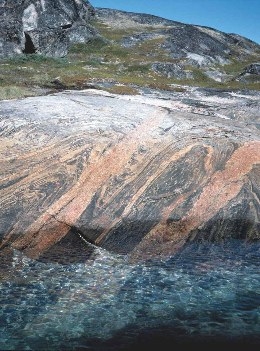
2 Geological Survey of Denmark and Greenland Bulletin 11 Keywords Archaean, Cretaceous Palaeogene, deformation, faulting, geochronology, Kangâmiut dykes, Nagssugtoqidian, Rinkian, West Greenland Cover Flat-lying, grey Archaean orthogneisses cut by Palaeoproterozoic dolerite dykes (black), which have been deformed and rotated into nearparallellism with their host rocks during the Nagssugtoqidian orogenesis. The whole succession is cut by late- to postkinematic Nagssugtoqidian pegmatites (pink). South coast of island 11 km east of Aasiaat in the northern Nagssugtoqidian orogen. The Nagssugtoqidian deformation of Archaean rocks in this region is the main subject of Mazur et al. (this volume) and van Gool & Piazolo (this volume). Photo: Adam A. Garde. Frontispiece: facing page Archaean, syn- to postkinematic granitic sheets cutting grey orthogneiss and variably folded with their host. Coastal exposure on the north coast of Saqqarput 30 km south-east of Kangaatsiaq, within an Archaean block in the northern Nagssugtoqidian orogen that has largely escaped Palaeoproterozoic deformation. Compare with the cover photograph displaying an example of Palaeoproterozoic deformation, and see articles by Mazur et al. and Thrane & Connelly (this volume). Photo: Adam A. Garde. Chief editor of this series: Adam A. Garde Editorial board of this series: John A. Korstgård, Geological Institute, University of Aarhus; Minik Rosing, Geological Museum, University of Copenhagen; Finn Surlyk, Geological Institute, University of Copenhagen Scientific editors of this volume: Adam A. Garde and Feiko Kalsbeek Editorial secretary: Esben W. Glendal Referees: Steffen Bergh (Norway), Clark Friend (UK), John Grocott (UK), Karen Hanghøj (USA), Paul Martin Holm (Denmark), Åke Johansson (Sweden), Graham Leslie (UK), Kenneth J.W. McCaffrey (UK), Allen P. Nutman (Australia), Chris Pulvertaft (Denmark), Andrew Saunders (UK) and three anonymous referees Illustrators: Adam A. Garde, Eva Melskens and Henrik Klinge-Pedersen Digital photographic work: Benny M. Schark Graphic production: Knud Consult, Odense, Denmark Printers: Schultz Grafisk, Albertslund, Denmark Receipt/acceptance dates of manuscripts: see end of individual articles Printed: 5 December 2006 ISSN ISBN-10: ISBN-13: Geological Survey of Denmark and Greenland Bulletin The series Geological Survey of Denmark and Greenland Bulletin replaces Geology of Denmark Survey Bulletin and Geology of Greenland Survey Bulletin. Citation of the name of this series It is recommended that the name of this series is cited in full, viz. Geological Survey of Denmark and Greenland Bulletin. If abbreviation of this volume is necessary, the following form is suggested: Geol. Surv. Den. Green. Bull. 11, 204 pp. Available from Geological Survey of Denmark and Greenland (GEUS) Øster Voldgade 10, DK-1350 Copenhagen K, Denmark Phone: , fax: , geus@geus.dk or Geografforlaget ApS Rugårdsvej 55, DK-5000 Odense C, Denmark Phone: , fax: , go@geografforlaget.dk Danmarks og Grønlands Geologiske Undersøgelse (GEUS),
3 3
4 Contents Preface A.A. Garde and F. Kalsbeek Evolution of Neoarchaean supracrustal belts at the northern margin of the North Atlantic Craton, West Greenland J.A. Hollis, M. Keiding, B.M. Stensgaard, J.A.M. van Gool and A.A. Garde Pre-Nagssugtoqidian crustal evolution in West Greenland: geology, geochemistry and deformation of supracrustal and granitic rocks north-east of Kangaatsiaq J.-F. Moyen and G.R. Watt A lead isotope study of an Archaean gold prospect in the Attu region, Nagssugtoqidian orogen, West Greenland H. Stendal, R. Frei and B.M. Stensgaard Origin and evolution of the Kangâmiut mafic dyke swarm, West Greenland K.R. Mayborn and C.E. Lesher Zircon geochronology from the Kangaatsiaq Qasigiannguit region, the northern part of the Ga Nagssugtoqidian orogen, West Greenland K. Thrane and J.N. Connelly Pb- 206 Pb dating of magnetite, monazite and allanite in the central and northern Nagssugtoqidian orogen, West Greenland H. Stendal, K. Secher and R. Frei New hornblende and muscovite 40 Ar/ 39 Ar cooling ages in the central Rinkian fold belt, West Greenland A.-S. Sidgren, L. Page and A.A. Garde Presentation and interpretation of structural data from the Nagssugtoqidian orogen using a GIS platform: general trends and features J.A.M. van Gool and S. Piazolo The Nordre Strømfjord shear zone and the Arfersiorfik quartz diorite in Arfersiorfik, the Nagssugtoqidian orogen, West Greenland K. Sørensen, J.A. Korstgård, W.E. Glassley and B.M. Stensgaard Structural analysis of the northern Nagssugtoqidian orogen, West Greenland: an example of complex tectonic patterns in reworked high-grade metamorphic terrains S. Mazur, S. Piazolo and G. I. Alsop Magnetic anomalies and metamorphic boundaries in the southern Nagssugtoqidian orogen, West Greenland J.A. Korstgård, B.M. Stensgaard and T.M. Rasmussen Faults and fractures in central West Greenland: onshore expression of continental break-up and sea-floor spreading in the Labrador Baffin Bay Sea R.W. Wilson, K.E.S. Klint, J.A.M. van Gool, K.J.W. McCaffrey, R.E. Holdsworth and J. A. Chalmers
5 Preface The present volume marks the completion of a large research project by the Geological Survey of Denmark and Greenland (GEUS), focused on the northern part of the Palaeoproterozoic Nagssugtoqidian orogen of central West Greenland, and carried out by a team of Danish and international participants. The project comprised geological mapping as well as structural, geochronological, geochemical and economic geological studies. This volume contains reports on both Archaean and Palaeoproterozoic geology as well as a study of neotectonic brittle structures. The field work was carried out in in the region between Nordre Strømfjord and Jakobshavn Isfjord (see e.g. van Gool & Piazolo 2006, this volume, fig. 1). The project had two immediate purposes, namely to establish an overview of the mineral resource potential of supracrustal rocks in the region between 66 and N, and produce four new geological sheets in the Survey s 1: map series. The first collection of papers about the Nagssugtoqidian orogen, published by the Geological Survey of Greenland (GGU, now part of GEUS), dates back to 1979 (Korstgård 1979). The investigations in this period were mainly based on field descriptions and structural analysis of coastal areas in the southern and central parts of the orogen, combined with limited petrographical, palaeomagnetic and geochronological studies; the results also comprised the first 1: geological map from within the Nagssugtoqidian orogen (Olesen 1984). The Proterozoic age of the orogen had been established, but it was believed that most, if not all of the quartzofeldspathic basement gneisses were of Archaean origin. Subsequent work in the Nagssugtoqidian orogen by GGU in the 1980s showed that besides Archaean orthogneisses and supracrustal rocks, the central part of the orogen also comprises the root zone of a Palaeoproterozoic magmatic arc and associated panels of Palaeoproterozoic volcanic and metasedimentary rocks (Kalsbeek et al. 1987). These results were confirmed during further investigations by the Danish Lithosphere Centre (DLC) in , and the plate-tectonic collisional history of the southern and central Nagssugtoqidian orogen was described in detail (van Gool et al. 2002). However, these studies added little to previous knowledge of the northern parts of the orogen in the Kangaatsiaq Aasiaat Qasigiannguit region, knowledge that was largely based on coastal reconnaissance by Henderson (1969) at the time when the entire orogen was still believed to consist of Archaean rocks. Another project preceding the present work was carried out by GGU in immediately north of the Nagssugtoqidian orogen, in the southernmost part of the likewise Palaeoproterozoic Rinkian fold belt (Disko Bugt project, Kalsbeek 1999). It was shown that also the latter region comprises Palaeoproterozoic (meta)sedimentary rocks, and that most of the Archaean basement is strongly overprinted by Palaeoproterozoic structures that were formed during overall W- or NW-directed lateral tectonic transport. Although these structures might be related to similar structures in the Nagssugtoqidian orogen, the relationship between the Nagssugtoqidian orogen and the Rinkian fold belt remained speculative. The only previous economic geological study of regional extent in central West Greenland was an airborne reconnaissance study supplemented by local field work, which was carried out in the early 1960s by Kryolitselskabet Øresund A/S. This work resulted in the discovery of a massive sulphide deposit at Naternaq (Lersletten), which was studied again in some detail in 2001 by the Survey (Østergaard et al. 2002) but not reported on in the present volume. The present volume comprises 12 papers with topics ranging geochronologically from mid-archaean to Palaeogene, and geographically from the southern Nagssugtoqidian foreland to the central part of the Rinkian fold belt. Many of the papers deal with the northern part of the Nagssugtoqidian orogen and are related to the recent field work in that region, while a few contributions are rooted in DLC- or other projects. The papers have been arranged in approximate chronological order and are grouped in terms of their main subjects. The two first papers, by Hollis et al. and Moyen & Watt, deal with Archaean supra- and infracrustal rocks in the northern Nagssugtoqidian orogen: their origin, ages, and structural and metamorphic evolution. These papers provide insight into the age and origin of the continental crustal orthogneisses and granites that underlie most of the region, and discuss the relationships between the supracrustal and plutonic components, using zircon U-Pb age determinations and major and trace element geochemical characteristics. Also the question of Palaeoproterozoic tectonic overprint is discussed, with the conclusion GEUS, Geological Survey of Denmark and Greenland Bulletin 11, 5 7. Available at: 5
6 from both study areas that most of the observed structures are Archaean. The third paper with focus on Archaean geology, by Stendal et al., describes a small gold prospect at Attu likewise in the northern Nagssugtoqidian orogen, and discusses the age of the prospect and its host rocks using Pb- Pb geochronology of magnetite. It is concluded that the host rocks at Attu may be as old as 3162 ± 43 Ma, and that the gold prospect itself is around 2650 Ma in age. The fourth paper, by Mayborn & Lesher, is a thorough review of the Kangâmiut dyke swarm in the southern Nagssugtoqidian orogen and its foreland. It includes new whole-rock and mineral chemical data, and a list of sampling sites and corresponding field data. The emplacement mechanism and depth of the dyke swarm are discussed in detail, and it is concluded that the dykes were emplaced during the initial rifting prior to the Nagssugtoqidian collision and that they are unrelated to subduction processes (contrary to the belief by some previous authors). The next three papers provide geochronological constraints on the ages of supra- and infracrustal rocks and the deformation and metamorphism in the northern Nagssugtoqidian orogen, and on late orogenic uplift in the central Rinkian fold belt. In the first of these papers Thrane & Connelly employ zircon U-Pb age determinations (mainly using the laser ICP-MS method), and for the first time provide unequivocal documentation that the Naternaq supracrustal belt is of Palaeoproterozoic age. Other zircon age data from a synkinematic granite southeast of Kangaatsiaq show that the large fold structures in this region are of Archaean age. The subsequent paper by Stendal et al. presents Pb-Pb ages and isotopic signatures of magnetite in amphibolites; the obtained ages are younger than 1800 Ma and are related to cooling of the orogen. Stepwise leaching Pb-Pb ages of monazite and allanite in pegmatites fall in the range of Ma, and are interpreted to date the emplacement of these rocks. The third paper in this group, by Sidgren et al., deals with new 40 Ar/ 39 Ar ages of around 1790 Ma (hornblende) and 1680 Ma (muscovite) from Archaean and Palaeoproterozoic rocks in the central Rinkian fold belt, which are interpreted as orogenic cooling ages. The hornblende ages are significantly older than such hornblende ages previously obtained from the central and northern Nagssugtoqidian orogen, pointing to different uplift histories in the two regions. This may in turn suggest that the Rinkian continental collision preceded that in the Nagssugtoqidian orogen. Four of the remaining five papers deal with the Nagssugtoqidian structural evolution. In the first of these, van Gool & Piazolo present a new method of structural analysis, where a geographical information system (GIS) is used as a framework for visualisation and analysis of large amounts of structural data. The paper graphically presents an overview of thousands of data points within an area of approximately km in the central and northern parts of the Nagssugtoqidian orogen. This interesting data set points directly towards the two next papers, where crustal-scale structures in the same region and their origin are discussed: Sørensen et al. address the prominent Nordre Strømfjord shear zone just south of this block, and describes the structural and metasomatic transition into the shear zone by means of aeromagnetic and lithological map patterns and geochemical data. Another paper, by Mazur et al., addresses a prominent break in the structural pattern within the Kangaatsiaq Aasiaat area, where the southern part acted as a rigid block during the Nagssugtoqidian orogeny and thus preserved its Archaean structure. The fourth paper in this group, by Korstgård et al., combines rock and aeromagnetic data to discuss the relationship between structure, metamorphic facies and total magnetic field intensity anomalies in the southern Nagssugtoqidian orogen. The authors show that static metamorphic boundaries are gradual, whereas boundaries along deformation zones are abrupt. The last paper, by Wilson et al., is a novel remote sensing and field geological analysis of onshore brittle structures related to the complex Ungava fault zone in the Davis Strait, which developed during the Cretaceous Palaeogene opening of the Labrador Sea Davis Strait Baffin Bay seaway. The study area is located in the central Nagssugtoqidian orogen, and the authors carefully establish a distinction between old Nagssugtoqidian and younger structures in the basement rocks and identify five main sets of young lineaments. They conclude that the onshore fault patterns are predominantly of strike-slip nature, and that they reflect the stress fields that governed the opening of the seaway. Acknowledgements The editors are grateful to the 14 external reviewers, each of whom reviewed one or more of the individual papers, for their thorough and constructive work. 6
7 References Henderson, G. 1969: The Precambrian rocks of the Egedesminde Christianshåb area, West Greenland. Rapport Grønlands Geologiske Undersøgelse 23, 37 pp. Kalsbeek, F. (ed.) 1999: Precambrian geology of the Disko Bugt region, West Greenland. Geology of Greenland Survey Bulletin 181, 179 pp. Kalsbeek, F., Pidgeon, R.T. & Taylor, P.N. 1987: Nagssugtoqidian mobile belt of West Greenland: a cryptic 1850 Ma suture between two Archaean continents chemical and isotopic evidence. Earth and Planetary Science Letters 85, Korstgård, J.A. (ed.) 1979: Nagssugtoqidian geology. Rapport Grønlands Geologiske Undersøgelse 89, 146 pp. Olesen, N.Ø. 1984: Geological map of Greenland, 1: , Agto 67 V.1 Nord. Copenhagen: Geological Survey of Greenland. Østergaard, C., Garde, A.A., Nygaard, J., Blomsterberg, J., Nielsen, B.M., Stendal, H. & Thomas, C.W. 2002: The Precambrian supracrustal rocks in the Naternaq (Lersletten) and Ikamiut areas, central West Greenland. Geology of Greenland Survey Bulletin 191, van Gool, J.A.M. & Piazolo, S. 2006: Presentation and interpretation of structural data from the Nagssugtoqidian orogen using a GIS platform: general trends and features. In: Garde, A.A. & Kalsbeek, F. (eds): Precambrian crustal evolution and Cretaceous Palaeogene faulting in West Greenland. Geological Survey of Denmark and Greenland Bulletin 11, (this volume). van Gool, J.A.M., Connelly, J.N., Marker, M. & Mengel, F.C. 2002: The Nagssugtoqidian orogen of West Greenland: tectonic evolution and regional correlation from a West Greenland perspective. Canadian Journal of Earth Sciences 39, Adam A. Garde and Feiko Kalsbeek 7
Magnetic anomalies and metamorphic boundaries in the southern Nagssugtoqidian orogen, West Greenland
 Magnetic anomalies and metamorphic boundaries in the southern Nagssugtoqidian orogen, West Greenland John A. Korstgård, Bo Møller Stensgaard and Thorkild M. Rasmussen Within the southern Nagssugtoqidian
Review of isotope data for Precambrian rocks from the Disko Bugt region, West Greenland
 Review of isotope data for Precambrian rocks from the Disko Bugt region, West Greenland Feiko Kalsbeek and Paul N. Taylor Pb-Pb and Rb-Sr isotope data yield whole-rock isochron ages of c. 2800 Ma for two
The Precambrian supracrustal rocks in the Naternaq (Lersletten) and Ikamiut areas, central West Greenland
 and Ikamiut areas, central West Greenland") The Precambrian supracrustal rocks in the Naternaq (Lersletten) and Ikamiut areas, central West Greenland Claus Østergaard,Adam A. Garde, Jeppe Nygaard, Jette Blomsterberg, Bo Møller Nielsen, Henrik Stendal
The Precambrian supracrustal rocks in the Naternaq (Lersletten) and Ikamiut areas, central West Greenland Claus Østergaard,Adam A. Garde, Jeppe Nygaard, Jette Blomsterberg, Bo Møller Nielsen, Henrik Stendal
Explanatory notes to the Geological map of Greenland, 1: , Ussuit 67 V.2 Nord
 GEOLOGICAL SURVEY OF DENMARK AND GREENLAND MAP SERIES 3 2007 Explanatory notes to the Geological map of Greenland, 1:100 000, Ussuit 67 V.2 Nord Jeroen A.M. van Gool and Mogens Marker GEOLOGICAL SURVEY
Review of Survey activities 2003
 GEOLOGICAL SURVEY OF DENMARK AND GREENLAND BULLETIN 4 2004 Review of Survey activities 2003 Edited by Martin Sønderholm and A.K. Higgins GEOLOGICAL SURVEY OF DENMARK AND GREENLAND MINISTRY OF THE ENVIRONMENT
Descriptive text to the Geological map of Greenland, 1: , Kangaatsiaq 68 V.1 Syd and Ikamiut 68 V.1 Nord
 GEOLOGICAL SURVEY OF DENMARK AND GREENLAND MAP SERIES 5 2010 Descriptive text to the Geological map of Greenland, 1:100 000, Kangaatsiaq 68 V.1 Syd and Ikamiut 68 V.1 Nord Adam A. Garde and Julie A. Hollis
2 Britain s oldest rocks: remnants of
 Britain s oldest rocks: remnants of Archaean crust 15 2 Britain s oldest rocks: remnants of Archaean crust 2.1 Introduction Owing to the complex nature of extremely old deformed rocks, the standard methods
Review of Survey activities 2006
 GEOLOGICAL SURVEY OF DENMARK AND GREENLAND BULLETIN 13 2007 Review of Survey activities 2006 Edited by Martin Sønderholm and A.K. Higgins GEOLOGICAL SURVEY OF DENMARK AND GREENLAND DANISH MINISTRY OF THE
The Jurassic of North-East Greenland
 GEOLOGICAL SURVEY OF DENMARK AND GREENLAND BULLETIN 5 2004 The Jurassic of North-East Greenland Edited by Lars Stemmerik and Svend Stouge GEOLOGICAL SURVEY OF DENMARK AND GREENLAND MINISTRY OF THE ENVIRONMENT
Geochemical Case Histories & Geochemical Exploration Methods. Paper 80
 Geochemical Case Histories & Geochemical Exploration Methods Geological and statistical validation of a gold-prediction model based on low-density surface geochemistry and other geoscientific data, Nuuk
Review of Survey activities 2004
 GEOLOGICAL SURVEY OF DENMARK AND GREENLAND BULLETIN 7 2005 Review of Survey activities 2004 Edited by Martin Sønderholm and A.K. Higgins GEOLOGICAL SURVEY OF DENMARK AND GREENLAND DANISH MINISTRY OF THE
Geochemical comparison between Archaean and Proterozoic orthogneisses from the Nagssugtoqidian orogen, West Greenland
 Precambrian Research 105 (2001) 165 181 www.elsevier.com/locate/precamres Geochemical comparison between Archaean and Proterozoic orthogneisses from the Nagssugtoqidian orogen, West Greenland Feiko Kalsbeek
North Greenland collection of oblique aerial photographs - (Twin Otter photos)
") North Greenland collection of oblique aerial photographs - (Twin Otter photos) The Geological Survey of Greenland (now part of the Geological Survey of Denmark and Greenland: GEUS) carried out a systematic
North Greenland collection of oblique aerial photographs - (Twin Otter photos) The Geological Survey of Greenland (now part of the Geological Survey of Denmark and Greenland: GEUS) carried out a systematic
IMSG Post-conference Field Guide
 IMSG 2017 - Post-conference Field Guide Jérémie Lehmann, Marlina Elburg and Trishya Owen-Smith The purpose of this short field excursion on Wednesday 18 January is to show a variety of rocks that make
Lisa Gaston NMT. Photo courtesy of Mike Williams. Matt Heizler
 Lisa Gaston NMT Photo courtesy of Mike Williams Matt Heizler Precambrian Geology Field Area 40 Ar/ 39 Ar results Do the pegmatites record intrusion ages? Conclusions Future work Precambrian provinces of
Global Tectonics. Kearey, Philip. Table of Contents ISBN-13: Historical perspective. 2. The interior of the Earth.
 Global Tectonics Kearey, Philip ISBN-13: 9781405107778 Table of Contents Preface. Acknowledgments. 1. Historical perspective. 1.1 Continental drift. 1.2 Sea floor spreading and the birth of plate tectonics.
Review of Survey activities 2005
 GEOLOGICAL SURVEY OF DENMARK AND GREENLAND BULLETIN 10 2006 Review of Survey activities 2005 Edited by Martin Sønderholm and A.K. Higgins GEOLOGICAL SURVEY OF DENMARK AND GREENLAND DANISH MINISTRY OF THE
GY 112 Lecture Notes Archean Geology
 GY 112 Lecture Notes D. Haywick (2006) 1 GY 112 Lecture Notes Archean Geology Lecture Goals: A) Time frame (the Archean and earlier) B) Rocks and tectonic elements (shield/platform/craton) C) Tectonics
Reconnaissance Pb-Pb dating of single mineral phases by the step-leaching method: results from the Caledonides of East Greenland
 Reconnaissance Pb-Pb dating of single mineral phases by the step-leaching method: results from the Caledonides of East Greenland Kristine Thrane Reconnaissance Pb-Pb step-leaching analyses have been carried
Prospectivity mapping for orogenic gold in South-East Greenland
 Prospectivity mapping for orogenic gold in South-East Greenland Björn H. Heincke & Bo Møller Stensgaard Presented by Kristine Thrane Geological Survey of Denmark and Greenland Danish Ministry of Climate,
Central West Greenland. 2. Lead
 Locality/Name: Region: Longitude: Latitude: Commodities: Economic significance: Maarmorillik, Black Angel Central West Greenland 51 15'9.2''W 71 9'14.6''N 1. Zinc 2. Lead Mine, closed Geological setting:
Curriculum Vitae Kyle R. Mayborn, Ph.D.
 Curriculum Vitae Kyle R. Mayborn, Ph.D. Interim Associate Dean, College of Arts and Sciences Professor of Geology Western Illinois University 1 University Circle Macomb, IL 61455 Education 2000 Ph.D. University
Tasiilaq a region unfolds and new findings
 Tasiilaq a region unfolds and new findings Regional overview with emphasize on new understanding and mineral potential Bo M. Stensgaard & Jochen Kolb GEUS & MMR SEGMENT participants Greenland Exploration
New geologic mapping + and associated economic potential on northern Hall Peninsula, Baffin Island, Nunavut
 New geologic mapping + and associated economic potential on northern Hall Peninsula, Baffin Island, Nunavut Holly Steenkamp, M.Sc. Regional Mapping Geoscientist David Mate, M.Sc. Chief Geologist November
Before Plate Tectonics: Theory of Continental Drift
 Before Plate Tectonics: Theory of Continental Drift Predecessor to modern plate tectonics Shape and fit of the continents was the initial evidence Snider-Pelligrini (1858) Taylor (1908) Wegner (1915) Fig.
Greenland from Archaean to Quaternary Descriptive text to the Geological map of Greenland, 1:
 GEOLOGY OF GREENLAND SURVEY BULLETIN 185 2000 Greenland from Archaean to Quaternary Descriptive text to the Geological map of Greenland, 1:2 500 000 Niels Henriksen, A.K. Higgins, Feiko Kalsbeek and T.
Topics Laramide Orogeny: Late Cretaceous to Early Eocene Reading: GSA DNAG volume 3, Ch. 6
 Topics Laramide Orogeny: Late Cretaceous to Early Eocene Reading: GSA DNAG volume 3, Ch. 6 Late Cretaceous to early Eocene New patterns developed 5 main regions Tectonic interpretations Post-Laramide events
Regional GIS based exploration targeting studies in data poor environments
 Regional GIS based exploration targeting studies in data poor environments A case study of gold prospectivity mapping in Nigeria Matthew Greentree, Mathieu Lacorde and Bert De Waele Acknowledgements Australian
Answers: Internal Processes and Structures (Isostasy)
") Answers: Internal Processes and Structures (Isostasy) 1. Analyse the adjustment of the crust to changes in loads associated with volcanism, mountain building, erosion, and glaciation by using the concept
Answers: Internal Processes and Structures (Isostasy) 1. Analyse the adjustment of the crust to changes in loads associated with volcanism, mountain building, erosion, and glaciation by using the concept
10. Paleomagnetism and Polar Wandering Curves.
 Map of ocean floor Evidence in Support of the Theory of Plate Tectonics 10. Paleomagnetism and Polar Wandering Curves. The Earth's magnetic field behaves as if there were a bar magnet in the center of
Comment on "A Vestige of Earth's Oldest Ophiolite"
 University of Wollongong Research Online Faculty of Science - Papers (Archive) Faculty of Science, Medicine and Health 2007 Comment on "A Vestige of Earth's Oldest Ophiolite" Allen P. Nutman University
Structure and history of the Kern Canyon fault system: introduction and thesis overview
 1 Chapter 1 Structure and history of the Kern Canyon fault system: introduction and thesis overview Exposures of fault zones from the surface to deep levels afford an opportunity to study the transition
Henrik Rasmussen and Paul Martin Holm
 Proterozoic thermal activity in the Archaean basement of the Disko Bugt region and eastern Nuussuaq, West Greenland: evidence from K-Ar and 40 Ar- 39 Ar mineral age investigations Henrik Rasmussen and
Copyright McGraw-Hill Education. All rights reserved. No reproduction or distribution without the prior written consent of McGraw-Hill Education
 Copyright McGraw-Hill Education. All rights reserved. No reproduction or distribution without the prior written consent of McGraw-Hill Education Tibetan Plateau and Himalaya -southern Asia 11.00.a VE 10X
RECONNAISSANCE GEOCHRONOLOGY OF THE INFRACRUSTAL ROCKS OF FLYVERFJORD, SCORESBY SUND, EAST GREENLAND
 RECONNAISSANCE GEOCHRONOLOGY OF THE INFRACRUSTAL ROCKS OF FLYVERFJORD, SCORESBY SUND, EAST GREENLAND DAVID C. REX AND ANDREW GLEDHILL REX, D. C. & GLEDHILL, A.: Reconnaissance geochronology of the infracrustal
Chapter 10: Deformation and Mountain Building. Fig. 10.1
 Chapter 10: Deformation and Mountain Building Fig. 10.1 OBJECTIVES Describe the processes of rock deformation and compare and contrast ductile and brittle behavior in rocks. Explain how strike and dip
CHAPTER VI CONCLUSIONS
 CHAPTER VI CONCLUSIONS In this Chapter, salient observations made in understanding the various tectonothermal events, including U-Pb in-situ monazite geochronology of Sargur schists and granulites exposed
Strike-Slip Faults. ! Fault motion is parallel to the strike of the fault.
 Strike-Slip Faults! Fault motion is parallel to the strike of the fault.! Usually vertical, no hanging-wall/footwall blocks.! Classified by the relative sense of motion. " Right lateral opposite block
New gold discovery in the Paleoproterozoic Mauken greenstone belt
 New gold discovery in the Paleoproterozoic Mauken greenstone belt Mauken greenstone belt The Paleoproterozoic Mauken greenstone belt is situated in an unexplored and untested terrain in Northern Norway.
Towards a tectonic framework for the Gawler Craton. Martin Hand Justin Payne, Greg Swain, Karin Barovich, Rian Dutch, Anthony Reid, Mike Schwarz
 Martin Hand Justin Payne, Greg Swain, Karin Barovich, Rian Dutch, Anthony Reid, Mike Schwarz The tectonic evolution of is defined by two periods of tectonism both of which lead to apparent cratonisation.
Geology 15 West Valley College. Exam IV: Sierra Nevada
 Geology 15 West Valley College Name Exam IV: Sierra Nevada 1) On the diagram above, where is the Arc- Trench Gap? a. 1 and 3 c. 7 and 8 d. 6 e. 5 and 10 2) On the diagram above, where is the subduction
GLY 155 Introduction to Physical Geology, W. Altermann. Press & Siever, compressive forces. Compressive forces cause folding and faulting.
 Press & Siever, 1995 compressive forces Compressive forces cause folding and faulting. faults 1 Uplift is followed by erosion, which creates new horizontal surface. lava flows Volcanic eruptions cover
Composition of the earth, Geologic Time, and Plate Tectonics
 Composition of the earth, Geologic Time, and Plate Tectonics Layers of the earth Chemical vs. Mechanical Chemical : Mechanical: 1) Core: Ni and Fe 2) Mantle: Mostly Peridotite 3) Crust: Many different
Do NOT open the test until instructed to do so.
 Raw Score: Rank: School: Team Number: Names: Boyceville Invitational, December 2, 2017 Dynamic Planet Plate Tectonics and Geographical Impacts Do NOT open the test until instructed to do so. 2011 Tohoku
OCN 201 Seafloor Spreading and Plate Tectonics. Question
 OCN 201 Seafloor Spreading and Plate Tectonics Question What was wrong from Wegener s theory of continental drift? A. The continents were once all connected in a single supercontinent B. The continents
Isan deformation, magmatism and extensional kinematics in the Western Fold Belt of the Mount Isa Inlier
 Isan deformation, magmatism and extensional kinematics in the Western Fold Belt of the Mount Isa Inlier Rick Gordon Department of Earth Sciences University of Queensland A thesis submitted for examination
Plate Tectonics GEOL 101 Lecture 22 How Are Mountains Built?
 Plate Tectonics GEOL 101 Lecture 22 How Are Mountains Built? The Grand Tetons, Wyoming First a Brief Review of Sea Floor Spreading Prop: Test 3 Invitations Break-Up of a Continent and Origin of an Ocean
TECTONIC AND STRUCTURAL CONTROLS ON INTRUSION- RELATED DEPOSITS IN THE NORTHERN PART OF SREDNA GORA ZONE, BULGARIA NIKOLAY PETROV & KAMELIA NEDKOVA
 TECTONIC AND STRUCTURAL CONTROLS ON INTRUSION- RELATED DEPOSITS IN THE NORTHERN PART OF SREDNA GORA ZONE, BULGARIA NIKOLAY PETROV & KAMELIA NEDKOVA INVESTIGATED AREA Praveshka Lakavica deposit Elatsite
Earthscope in the Northern Rockies Workshop
 Earthscope in the Northern Rockies Workshop Co-conveners: David Foster - University of Florida Paul Mueller - University of Florida David Mogk - Montana State University EarthScope in the Northern Rockies
Captain s Tryouts 2017
 Captain s Tryouts 2017 Dynamic Planet Test Written by: Araneesh Pratap (Chattahoochee High School) Name: Date: Answer all questions on the answer sheet. Point values are given next to each question or
NAME HOMEWORK ASSIGNMENT #4 MATERIAL COVERS CHAPTERS 19, 20, 21, & 2
 NAME HOMEWORK ASSIGNMENT #4 MATERIAL COVERS CHAPTERS 19, 20, 21, & 2 Assignment is due the beginning of the class period on December 14, 2004. Mark answers on a scantron sheet, which will be provided.
EXISTING GEOLOGICAL INFORMATION
 CHAPER 3 EXISTING GEOLOGICAL INFORMATION 3-1 General Geology of the Surrounding Area (1) General geology and ore deposits in Mongolia Geographically, Mongolia is a country located between Russia to the
Distribution of Continents Mid-ocean Ridges Trenches. Deformation Metamorphism Volcanism Earthquakes
 Earthquakes and Plate Tectonics Global Problems in Geology Distribution of Continents Mid-ocean Ridges Trenches Orogenic Belts Deformation Metamorphism Volcanism Earthquakes Development of Continental
Figure GS-25-1: General geology and domain subdivisions in northwestern Superior Province. 155
 GS-25 ASSEAN LAKE ANCIENT CRUST: AN UPDATE by M.T. Corkery, Ch.O. Böhm 1 and L.M Heaman 1 Corkery, M.T., Böhm, Ch.O. and Heaman, L.M. 2000: Assean Lake ancient crust: an update; in Report of Activities
Basin Analysis. Stra-graphy
 Basin Analysis Stra-graphy Basin Analysis Basin analysis integrates program sedimentological, stra-graphic, and tectonic principals to develop a full understanding of the rocks that fill sedimentary basins.
GEOLOGICAL INVESTIGATION IN THE ISLAND LAKE GREENSTONE BELT, NORTHWESTERN SUPERIOR PROVINCE, MANITOBA (PARTS OF NTS 53E/15 & 16) GS-18
 GS-18") GS-18 GEOLOGICAL INVESTIGATION IN THE ISLAND LAKE GREENSTONE BELT, NORTHWESTERN SUPERIOR PROVINCE, MANITOBA (PARTS OF NTS 53E/15 & 16) by S. Lin, H.D.M. Cameron, E.C. Syme and F. Corfu 1 Lin, S., Cameron,
GS-18 GEOLOGICAL INVESTIGATION IN THE ISLAND LAKE GREENSTONE BELT, NORTHWESTERN SUPERIOR PROVINCE, MANITOBA (PARTS OF NTS 53E/15 & 16) by S. Lin, H.D.M. Cameron, E.C. Syme and F. Corfu 1 Lin, S., Cameron,
Earth s Tectonic Evolution
 Earth s Tectonic Evolution Name: Spring, 19xx Geology 230: Test # 3 Date: Time Begun: Time Ended: Rules for All Lecture Tests Lynn S. Fichter James Madison University ( You have a several day period in
DEFORMATION AND METAMORPHISM OF THE AILEU FORMATION, EAST TIMOR. R. F. Berry (B.Sc. Hons.) SCHOOL OF EARTH SCIENCES. May 1979
 SCHOOL OF EARTH SCIENCES. May 1979") DEFORMATION AND METAMORPHISM OF THE AILEU FORMATION, EAST TIMOR. by R. F. Berry (B.Sc. Hons.) SCHOOL OF EARTH SCIENCES FLINDERS UNIVERSITY OF SOUTH AUSTRALIA May 1979 i TABLE OF CONTENTS page Table of
DEFORMATION AND METAMORPHISM OF THE AILEU FORMATION, EAST TIMOR. by R. F. Berry (B.Sc. Hons.) SCHOOL OF EARTH SCIENCES FLINDERS UNIVERSITY OF SOUTH AUSTRALIA May 1979 i TABLE OF CONTENTS page Table of
Lab 1: Plate Tectonics April 2, 2009
 Name: Lab 1: Plate Tectonics April 2, 2009 Objective: Students will be introduced to the theory of plate tectonics and different styles of plate margins and interactions. Introduction The planet can be
Introduction to: The Rocky Mountain Region An Evolving Lithosphere: Tectonics, Geochemistry, and Geophysics
 Introduction to: The Rocky Mountain Region An Evolving Lithosphere: Tectonics, Geochemistry, and Geophysics Karl E. Karlstrom Department of Earth and Planetary Sciences, University of New Mexico, Albuquerque,
Parts of the Sevier/ Laramide Orogeny
 Parts of the Sevier/ Laramide Orogeny AA. Accretionary Prism BB. Forearc Basin Sediment scraped off of subducting plate Sediment derived from the volcanic arc CC. Volcanic Arc Magmatic intrusion into the
GEOLOGY - Tectonic Setting and Tectonometamorphic Evolution of Fuping-Wutai- Hengshan Orogenic Belt, China
 GEOLOGY - Tectonic Setting and Tectonometamorphic Evolution of Fuping-Wutai- Hengshan Orogenic Belt, China Title Summary of Proposed Research Program for Doctor of Philosophy Tectonic Setting and Tectonometamorphic
History of Earth. Chapter 9: HISTORY OF EARTH. The Solar System. Early Earth: A Giant Impact! Early Earth. Formation of the Solar System
 Chapter 9: HISTORY OF EARTH The Essential Earth, 2 nd Edition Thomas H. Jordan & John Grotzinger History of Earth Earth is 4.56 Billion Years Old Earth has experienced a rich and diverse history that we
Questions and Topics
 Plate Tectonics and Continental Drift Questions and Topics 1. What are the theories of Plate Tectonics and Continental Drift? 2. What is the evidence that Continents move? 3. What are the forces that
GEOLOGY AND GEOCHRONOLOGY OF THE ISLAND LAKE GREENSTONE BELT, NORTHWESTERN SUPERIOR PROVINCE by J. Parks 1, S. Lin 1, M.T. Corkery and D.W.
 GS-17 GEOLOGY AND GEOCHRONOLOGY OF THE ISLAND LAKE GREENSTONE BELT, NORTHWESTERN SUPERIOR PROVINCE by J. Parks 1, S. Lin 1, M.T. Corkery and D.W. Davis 2 Parks, J., Lin, S., Corkery, M.T. and Davis, D.W.
LAB 6: TRINIDAD BEACH FIELD TRIP
 OBJECTIVES: LAB 6: TRINIDAD BEACH FIELD TRIP 1) to develop your powers of observation, especially of geological phenomena; 2) to identify the rocks exposed at Trinidad Beach; 3) to reconstruct some of
Report of Activities 2003 Published by: Manitoba Industry, Economic Development and Mines Manitoba Geological Survey, 2003.
 Report of Activities 2003 Published by: Manitoba Industry, Economic Development and Mines Manitoba Geological Survey, 2003. ERRATA: The publisher/department name in the bibliographic reference cited immediately
Earth s Continents and Seafloors. GEOL100 Physical Geology Ray Rector - Instructor
 Earth s Continents and Seafloors GEOL100 Physical Geology Ray Rector - Instructor OCEAN BASINS and CONTINENTAL PLATFORMS Key Concepts I. Earth s rocky surface covered by of two types of crust Dense, thin,
Adam A. Garde, Brian Chadwick, John Grocott and Cees Swager
 Metasedimentary rocks, intrusions and deformation history in the south-east part of the c. 1800 Ma Ketilidian orogen, South Greenland: Project SUPRASYD 1996 Adam A. Garde, Brian Chadwick, John Grocott
INTRODUCTION. Basalt, the widespread igneous rock on the earth sur-face. today appear to have been equally important
 INTRODUCTION Basalt, the widespread igneous rock on the earth sur-face today appear to have been equally important in the geologic past. Basaltic rocks are mostly partial melting products of the upper
Copper-gold mineral systems in the southeastern Gawler Craton -
 Copper-gold mineral systems in the southeastern Gawler Craton - another Mt Isa Eastern Succession? Ollie Raymond 1, Ian Fletcher 2 and Neal McNaughton 2 1 Geoscience Australia, Canberra, ACT, 2601 2 Centre
Plate Tectonics. Structure of the Earth
 Plate Tectonics Structure of the Earth The Earth can be considered as being made up of a series of concentric spheres, each made up of materials that differ in terms of composition and mechanical properties.
Review of Survey activities 2012
 GEOLOGICAL SURVEY OF DENMARK AND GREENLAND BULLETIN 28 2013 Review of Survey activities 2012 Edited by Ole Bennike, Adam A. Garde and W. Stuart Watt GEOLOGICAL SURVEY OF DENMARK AND GREENLAND MINISTRY
Bedrock mapping and geological characterization in the northern Glennie domain, west-central Reindeer Zone
 Bedrock mapping and geological characterization in the northern Glennie domain, west-central Reindeer Zone Samantha Van De Kerckhove, Ryan Morelli and Dylan Deck Saskatchewan Geological Open House, 2017
REGIONAL PERSPECTIVES
 2917-CH20.pdf 11/20/03 5:24 PM Page 501 PART E REGIONAL PERSPECTIVES 501 2917-CH20.pdf 11/20/03 5:24 PM Page 502 C H A P T E R T W E N T Y A Global View 20.1 Introduction 502 20.2 Global Deformation Patterns
7 Sedimentation and tectonics at a mid- Ordovician to Silurian active margin
 80 Mountain Building in Scotland 7 Sedimentation and tectonics at a mid- Ordovician to Silurian active margin 7.1 Introduction In mid-ordovician to Silurian times, the Grampian mountains underwent exhumation,
Chapter 3. Geology & Tectonics
 Chapter 3 Geology & Tectonics 3.1 Geology The general geological features of Indonesia are shown in Figure 3.1. The basement formation is metamorphic and it is intruded with plutonic formations. They are
Geologic History of Texas: The Making of Texas Over 1.5 Billion Years
 # 4 Geologic History of Texas: The Making of Texas Over 1.5 Billion Years Dr. Richard Kyle March 24, 2000 Produced by and for Hot Science - Cool Talks by the Environmental Science Institute. We request
The Lead 206/207 Dating Method
 The Lead 206/207 Dating Method 1 U Pb Zircon Ages, Chemical Geology, Volume 211 (2004) Pages 87 109 2 Lead Isotope Planetary Profiling, Chemical Geology, Volume 233 (2006) Pages 1 45 3 U Pb Step-Leaching
Quality control of airborne geophysical data from the EU Mining Sector Support Programme, Ghana
 Downloaded from orbit.dtu.dk on: Nov 13, 2018 Quality control of airborne geophysical data from the EU Mining Sector Support Programme, Ghana Rasmussen, Thorkild M.; Thorning, Leif; Olesen, Arne Vestergaard;
McClelland & Oldow, p. 1
 McClelland & Oldow, p. 1 U-Pb Analytical Methods Zircons were separated from each of the seven 1 to 4 kg samples samples (see Fig. 1 for locations) by standard crushing and gravimetric techniques, picked
Plate tectonics - 3. Homework 1: Due Monday. Hot Spots Magnetic Reversals Isostasy Continental Tectonics. EESC 2200 The Solid Earth System.
 2500 EESC 2200 The Solid Earth System Plate tectonics - 3 17 Sep 08 Hot Spots Magnetic Reversals Isostasy Continental Tectonics Depth (m) 6000 0 9 36 100 155 Homework 1: Due Monday Review: Fracture zone
Chapter 16. Mountain Building. Mountain Building. Mountains and Plate Tectonics. what s the connection?
 Chapter 16 Mountains and Plate Tectonics what s the connection? Mountain Building Most crustal deformation occurs along plate margins. S.2 Active Margin Passive Margin Mountain Building Factors Affecting
35th Annual GCSSEPM Foundation Bob F Perkins Research Conference 2016
 35th Annual GCSSEPM Foundation Bob F Perkins Research Conference 2016 Mesozoic of the Gulf Rim and Beyond: New Progress in Science and Exploration of the Gulf of Mexico Basin Houston, Texas, USA 8 9 December
Plate Tectonics 22/12/2017
 Map of the tectonic plates. Plate Tectonics In 1912 the meteorologist Alfred Wegener independently developed what he called continental drift, (expanded in his 1915 book The Origin of Continents and Oceans).
Secular Archaean. Pronounced secular trends from. However, also. Cr, intermediate to felsic magmas, and
 Secular Archaean Pronounced secular trends from 1. early sodic granites (TTGs) 2. later potassic granites However, also 1. LILE- & LREE-enriched, high MgO, Mg#, Ni, Cr, intermediate to felsic magmas, and
predictive iscovery Why is the gold where it is? redictive mineral ineral discovery pmd CRC
 The Y2 project (2001-2004) Time-space evolution of the Yilgarn Craton: implications for geodynamics Kevin Cassidy and the Y2 team Reduced D Risk through Improved Targeting ineral d Why is the gold where
Full file at CHAPTER 2 The Way the Earth Works: Plate Tectonics
 CHAPTER 2 The Way the Earth Works: Plate Tectonics MULTIPLE CHOICE 1. Wegener proposed continental drift after he observed evidence from fossils, glacial deposits, and the fit of the continents that suggested
6. In the diagram below, letters A and B represent locations near the edge of a continent.
 1. Base your answer to the following question on the cross section below and on your knowledge of Earth science. The cross section represents the distance and age of ocean-floor bedrock found on both sides
Figure 1. Examples of vector displacement diagrams for two and three-plate systems.
 Figure 1. Examples of vector displacement diagrams for two and three-plate systems. Figure 2. Relationships between pole of rotation, great circles, ridge segments, small circles, transforms and fracture
Geochronology of Catalina Island Schist and Future Work. Island Schist, we look into geochronological data to constrain the timeline of various
 Maria delos Angeles Cuevas May 4, 2015 Professor John Platt Geochronology of Catalina Island Schist and Future Work Abstract Taking into consideration the various issues involving the exhumation of Catalina
2017 Fowler Domain & Western Gawler Craton SkyTEM 312 AEM Survey, South Australia
 2017 Fowler Domain & Western Gawler Craton SkyTEM 312 AEM Survey, South Australia Geoscience Australia & the Geological Survey of South Australia D.J McInnes Geoscience Australia ecat ID 121550 Department
GOLD IN MANITOBA SHORT COURSE
 November 20-22 GOLD IN MANITOBA SHORT COURSE D. Lentz Developing the Orogenic Gold Deposit Model: Insights from R&D for Exploration Success View Abstract B. Lafrance Structural Controls on Hydrothermal
New insights on the THO-Superior boundary: Tectonic and metallogenic implications
 New insights on the THO-Superior boundary: Tectonic and metallogenic implications John Percival, GSC Nicole Rayner, GSC Herman Zwanzig, MGS Linda Murphy, MGS Joe Whalen, GSC Martha Growdon, Indiana U.
For personal use only
 22 April 2013 Drilling to commence at Majada, Copper-Gold Prospect, Chile. Red Gum Resources Limited (ASX: RGX, Red Gum or the Company ) is pleased to announce that drilling of its Majada Copper-Gold Prospect,
Chapter Two. Figure 02_02. Geography of the Ocean Basins. The Sea Floor
 Chapter Two The Sea Floor Geography of the Ocean Basins Figure 02_02 The world ocean is the predominant feature on the Earth in total area. In the Northern Hemisphere, 61% of the total area is ocean. In
ARTICLE IN PRESS. Received 16 October 2003; accepted 2 September 2004
 DTD 5 Lithos xx (2004) xxx xxx www.elsevier.com/locate/lithos Mantle wedge involvement in the petrogenesis of Archaean grey gneisses in West Greenland Agnete Steenfelt a, *, Adam A. Garde a, Jean-François
Geology of the Hawaiian Islands
 Geology of the Hawaiian Islands Class 3 20 January 2004 Any Questions? IMPORTANT Big Island Field Trip We need a firm commitment PLUS $164 payment for airfare BEFORE January 29th Plate Tectonics Fundamental
Review of Survey activities 2016
 GEOLOGICAL SURVEY OF DENMARK AND GREENLAND BULLETIN 38 2017 Review of Survey activities 2016 Edited by Adam A. Garde and Ole Bennike GEOLOGICAL SURVEY OF DENMARK AND GREENLAND DANISH MINISTRY OF ENERGY,
Plate Tectonics. entirely rock both and rock
 Plate Tectonics I. Tectonics A. Tectonic Forces are forces generated from within Earth causing rock to become. B. 1. The study of the origin and arrangement of Earth surface including mountain belts, continents,