geodynamics
|
|
|
- Lenard Daniels
- 5 years ago
- Views:
Transcription
1 FGI report on geodynamics Ruotsalainen H., M.Poutanen J. Mäkinen, M. Bilker- Koivula, M. Nordman, V. Saaranen K. Arsov, N.Zubko, H. Virtanen, U.Kallio, J. Jokela, P. Häkli, H. Koivula, J. Näränen, A.Raja-Halli
2 Topics I 2010 Activity 1. Absolute gravimetry FOGN with A10 & Abs. grav with FG5 2. Relative gravimetry & GPS Supporting measurement for FOGN 3. Superconducting gravimetry Hydrological studies 4.Long interferometrical watertube tiltmeter Recordings, Baltic Sea and Arctic Sea loading? 5.Geo-VLBI IVS-T2 and EUROPE geovlbi campaigns 6. Satellite Laser Ranging system modernization II New structure of Dept of Geodesy and Geodynamics III Project plans in 2011
3 First order gravity net remeasurement with A10 in cooperation with FGI and Institute of Geodesy and Cartography,Warsaw FOGN in 1963, Kiviniemi Publ. 59, 1964 N K G Ge ner al As se mb ly 20 10, Su
4 FOGN present status N K G G e n er al A ss e m bl measured by Aimo Kiviniemi, Worden Master 227 present zero and scale derived from a readjustment into IGSN71 by T. Honkasalo in 1971 epoch , mean tide system (from IGSN71) original estimate for accuracy of gravity differences mgal (one-sigma) control measurement in 1988 by Kiviniemi performed in large loops, 2 x LCR-G (G-55, G-600) rms for discrepancies ( ) of gravity differences without correction for land uplift was mgal (JM) values of preserved stations were not revised in 1988
5 Re-measurement of the FOGN N K G G e n er al A ss e m bl Future uses of the FOGN shall be the same as the old uses: reference for gravity survey in other words, no geodynamical task added old stations retained and remeasured with A10 co-operation with IGiK Warsaw A of IGiK operated by Marcin Sekowski 19 FOGN sites occupied in 2009 and 32 sites in 2010 Supporting measurements started in 2010, will be completed in 2011

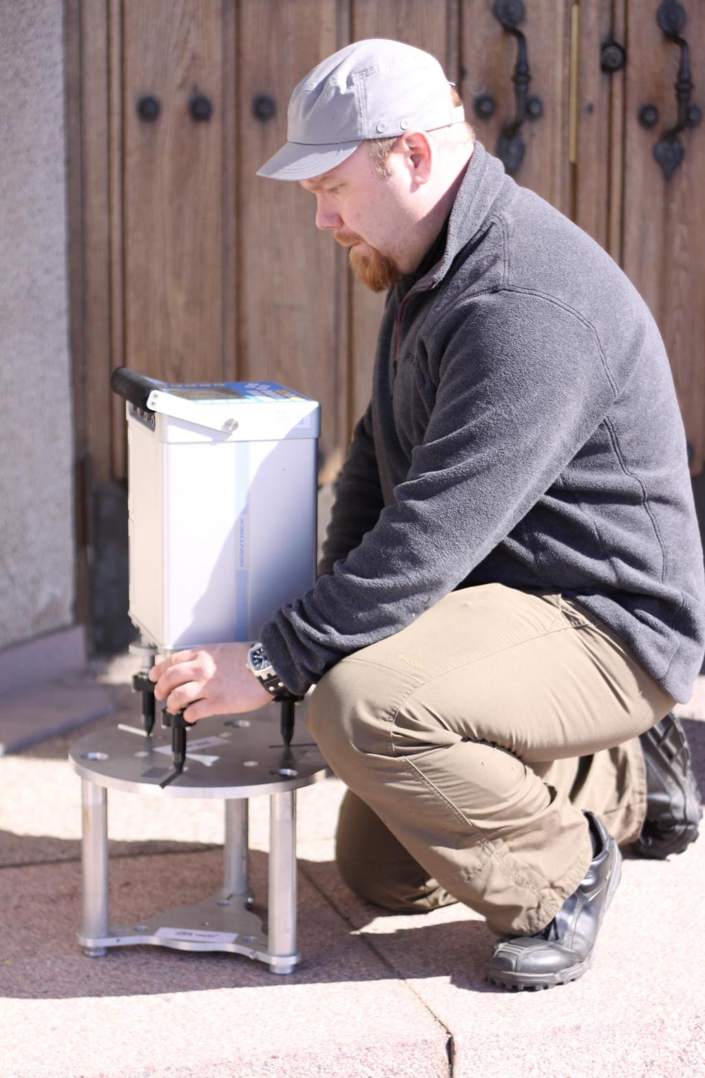
6 A10-20 at FOGN station (Asikkala)
7 Final network of new FOGN 51 sites measured with A10 Circles: Control sites with FG5 results (Mäkinen, NKG GA, Sundvolden, 2010)
8 Isolines (unit µgal) show expected gravity change due to PGR, (Mäkinen, NKG GA, Sundvolden, 2010)
9 Difference, µgal 50 A results minus FOGN values y = -0.28x Total uplift, mm N K G G e n er al A ss e m bl A minus FOGN (when corrected to zerotide) vs. total uplift in mm estimated from NKG2005LU_ABS Slope µgal/mm is too steep! Should be about 0.15 µgal/mm (Mäkinen, NKG GA, Sundvolden, 2010)
10 Supporting geodetic and gravimetry measurements separate 2-person expedition, will be completed in level gradients for A10 computation, for users, and for connecting Worden in at about 0.5 m height (tripod) LCR-G in 1988 at about 0.16 m height (plate) A in at m relative ties when FOGN and A10 stations are not same levelling to BM with better than 1 cm accuracy 3-D coordinates from VRS-GPS in combination with tachymeter plan was to make terrestrial laser scan of sites but scanner was busy elsewhere most of 2010 photos, sketches, dimensions, control distances
11
12
13 Papers of FOGN measurements Mäkinen J., Sękowski M., Kryński J., Ruotsalainen H., (2010a): Gravity change in Finland fromcomparison of new measurements using the outdoor absolute gravimeter A10 with legacy relative measurements first results, Geophysical Research Abstracts Vol. 12, EGU , EGU General Assembly 2010, 2 7 May 2010, Vienna, Austria, Abstract. Mäkinen J., Sękowski M., Kryński J., Ruotsalainen H., (2010b): Updating the Finnish first order gravity network using the outdoor absolute gravimeter A10, IAG Symposium on Terrestrial Gravimetry: Static and Mobile Measurements (TG-SMM2010), June 2010, Saint Petersburg, Russia, Abstract. Manuscript of measurements submitted to Polish Geoinformation Issues, October 21, 2010 by Mäkinen, Krynski and Secowski
14 Absolute gravity with FG5 in 2010 Metsähovi_AB, Vaasa AA&AB, Joensuu, Kuusamo, Sodankylä and Kevo remeasured Aug-Sep by HR & Co Results obtained expected J. Näränen in FG5 training school in Micro-g Solutions in Colorado USA 9/2010


15 SG-TT20, Metsähovi Virtanen H., et al. Photo: H. Virtanen
16 Present goals of SG study Research work with SG T020 has been concentrated on hydrological studies. Test field around laboratory (within distance 100m-150m) consist of 13 groundwater tubes, 5 tubes for radiometric measurements, 54 soil moisture sensors and soil resistivity field with 441 probes. A key question is the separation of the attraction of nearfield water storage from the loading effect of the regional water storage, as the two are strongly correlated and the size of the former depends on very local hydrogeology around the SG. Modeling the local hydrology would allow us to use the SG to check regional hydrology from GRACE. The ambition of hydrological studies, using T020 is to verify and develop gravity and hydrological models in the spatial scales from regional (Finland) to continental (European).

17 Interferometrical water tube tiltmeter, Lohja Photo: H. Ruotsalainen NSWT recording continued, GGP filters tested and tidal tilt analyse carried out with old and new data Baltic Sea loading studies continued Microseismic storms and its spectral response together with SG in Metsähovi studied Free oscillations after big earthquakes (Chilean earthquake under study)

18 NSWT/SG spectra from microseismic storm Red - NSWT-spectrum Green SG GWR-TT20 spectrum
. In 2010 started to analyze VLBI sessions with VieVS software (Vienna University of Technology).")
19 Geodetic-VLBI FGI: Saaranen, Arsov, Zybko Aalto Univ., Metsähovi Radio Observatory: Molera, Mujunen,Ritakari, Wagner,Oinaskallio, Uunila Photo. M. Poutanen Participation in IVS-T2 and EUROPE geovlbi campaigns coordinated by International VLBI Service. During 2010 participated in 7 geovlbi sessions (VS, NZ). In 2010 started to analyze VLBI sessions with VieVS software (Vienna University of Technology). The EUROPE and IVS- T2 sessions of years have been analyzed by Nataliya Zubko for the study of the difference of crustal movements obtained with EUROPE and IVS-T2 networks.

20 SLR renovation, Metsähovi Arsov, Näränen, Raja-halli Photo: M.Poutanen Renovation work continues


21 Osaston yleinen rakenne ja tehtävät / General structure and tasks of the Department 1 Kansalliset koordinaatti-, korkeus- ja painovoimajärjestelmät National reference frames, height and gravity systems Kansainväliset järjestelmät International systems 2 Yhdistäminen, aikasarjat, analyysi, maankuoren liikkeet Combination, time series, analysis, geodynamics Relative gravimetry VLBI Other geodetic measurements 3 AG SLR Maintenance of infrastructures SCG GNSS 4 Height determinatio n Other space geodetic obs Metrologia ja laatu / Metrology and quality
22 Geodynamics in 2011 ABS GRAV FG5 measurements in Finnish stations Aug. FG5 comparison LMV 3/2011 in Metsähovi, Moscow, ST. Petersburg, Luxembourg comparisons FG5 measurements in Antarctica at the end of year
23 FOGN relative gravimetry measurements measurements continue in May June in Northern Finland and field works are tried to be finalized before July.
geodynamics
 FGI activity report on geodynamics 2009-2010 Ruotsalainen H., J. Mäkinen, M. Bilker- Koivula, M. Nordman, V. Saaranen,K.Arsov, J.Virtanen, H. Virtanen, U.Kallio, J. Jokela, P. Häkli, H. Koivula, M.Poutanen,
Hannu E Ruotsalainen Finnish Geodetic Institute Masala, Finland
 Hannu E Ruotsalainen Finnish Geodetic Institute Masala, Finland Historical interferometric water level tiltmeters in geodynamics Old NSWT and EWWT tilt meter observations of the FGI in 1977-1996 in Lohja,
Comparison between measurements with the superconducting gravimeter T020 and the absolute gravimeter FG5-221 at Metsähovi, Finland in
 Comparison between measurements with the superconducting gravimeter T020 and the absolute gravimeter FG5-221 at Metsähovi, Finland in 2003-2012 H. Virtanen,, M. Bilker-Koivula, J. Mäkinen J. Näränen, A.
GPS time series and sea level
 GPS time series and sea level M. Poutanen 1, H. Koivula 1, M. Tervo 1,2, K. Kahma 3, M. Ollikainen 1, H. Virtanen 1 1 Finnish Geodetic Institute, 2 University of Helsinki, 3 Finnish Institute of Marine
Borowa Gora (BG) IGETS Station Report
 IGETS Station Report") Borowa Gora (BG) IGETS Station Report Przemyslaw Dykowski, Marcin Sekowski, Jan Krynski Institute of Geodesy and Cartography, Warsaw, Poland przemyslaw.dykowski@igik.edu.pl IGETS Business meeting 2017.07.03,
Borowa Gora (BG) IGETS Station Report Przemyslaw Dykowski, Marcin Sekowski, Jan Krynski Institute of Geodesy and Cartography, Warsaw, Poland przemyslaw.dykowski@igik.edu.pl IGETS Business meeting 2017.07.03,
Geodetic Observing Systems: tools in observing the Glacial Isostatic Adjustment. Markku Poutanen Finnish Geodetic Institute
 Geodetic Observing Systems: tools in observing the Glacial Isostatic Adjustment Markku Poutanen Finnish Geodetic Institute Glacial Isostatic Adjustment Land uplift is just one consequence of the physical
Establishment of a Global Absolute Gravity Network
 Establishment of a Global Absolute Gravity Network H. Wilmes 1), H. Wziontek 1), R. Falk 1), J. Ihde 1), S. Bonvalot 2), R. Forsberg 3), S. Kenyon 4), L. Vitushkin 5) 1) Federal Agency for Cartography
GGOS, ECGN and NGOS: Global and regional geodetic observing systems. Markku Poutanen Finish Geodetic Institute
 GGOS, ECGN and NGOS: Global and regional geodetic observing systems Markku Poutanen Finish Geodetic Institute Contents GGOS, ECGN, NGOS Why? How? Future? (geodesy) GGOS Structure GGOS Structure European
Status. EUREF TWG Meeting November 8 9, 2004, Praha
 ECGN was initiated by IAG Sub-Commission for Europe EUREF (SC1.3a) and IAG Sub-Commission for Europe of the International Gravity and Geoid Commission (IGGC) with relationship to Joint Research Centre
ECGN - Development of the European Combined Geodetic Network in Austria
 ECGN - Development of the European Combined Geodetic Network in Austria Diethard Ruess 1, Gelöscht: BEV Dept. Control Survey Abstract Austria takes part in the European Combined Geodetic Network - Project
National Report for Finland. Jaakko Mäkinen, Markku Poutanen, Hannu Koivula, Matti Ollikainen, Hannu Ruotsalainen and Heikki Virtanen
 Nordic Geodetic Commission Joint Meeting of Working Group for Geodynamics Working Group for Satellite Geodesy Working group for Geoid Determination Hönefoss, October 8 to 10, 2001 National Report for Finland
NATIONAL REPORT OF POLAND TO EUREF 2011
 NATIONAL REPORT OF POLAND TO EUREF 2011 Jan Krynski Institute of Geodesy and Cartography, Warsaw Jerzy B. Rogowski Warsaw University of Technology, Warsaw Outline Main geodetic activities at the national
Nordiska kommissionen för Geodesi Nordic Geodetic Commission
 Nordiska kommissionen för Geodesi Nordic Geodetic Commission Working Group for Geodynamics Minutes of the 30 th meeting of the Working Group for Geodynamics within the Nordic Geodetic Commission University
Status report of the BKG Gravity Group
 Status report of the BKG Gravity Group Hartmut Wziontek, Herbert Wilmes, Reinhard Falk, Jan Müller Federal Agency for Cartography and Geodesy Frankfurt/Main, Germany Outline TIGO/Concepcion (Chile): gravity
Advances in Ground-based Gravity for Hydrologic Studies
 Advances in Ground-based Gravity for Hydrologic Studies L. Longuevergne (1,2), C.R. Wilson 1, B.R. Scanlon 2 1 Department of Geological Sciences, UT Austin 2 Bureau of Economic Geology, UT Austin What
Warkworth geodetic station as a potential GGOS core site in New Zealand
 "Launching the Next-Generation IVS Network Session 2: Correlators, Stations and Operations Centers. 7th IVS General Meeting March 5, 2012 Madrid, Spain Warkworth geodetic station as a potential GGOS core
An Accuracy Assessment of Absolute Gravimetric Observations in Fennoscandia
 Nordic Journal of Surveying and Real Estate Research Volume 7, Number 1, 2010 Nordic Journal of Surveying and Real Estate Research 7:1 (2010) 7 14 submitted on March 12, 2009 revised on February 20, 2010
Results of the Seventh International Comparison of Absolute Gravimeters ICAG-2005 at the Bureau International des Poids et Mesures, Sèvres
 Chapter 7 the Seventh International Comparison of Absolute Gravimeters ICAG-2005 at the Bureau International des Poids et Mesures, Sèvres L. Vitushkin, Z. Jiang, L. Robertsson, M. Becker, O. Francis, A.
A New Transformation Including Deformation Model for the Nordic and Baltic Countries
 A New Transformation Including Deformation Model for the Nordic and Baltic Countries Pasi HÄKLI, Finland, Martin LIDBERG, Sweden, Lotti JIVALL, Sweden, Torbjørn NØRBECH, Norway, Oddvar TANGEN, Norway,
The Global Geodetic Observing System (GGOS) of the International Association of Geodesy, IAG
 of the International Association of Geodesy, IAG") The Global Geodetic Observing System (GGOS) of the International Association of Geodesy, IAG Hans-Peter Plag (1), Markus Rothacher (2), Richard Gross (3), Srinivas Bettadpur (4) (1) Nevada Bureau of Mines
The Global Geodetic Observing System (GGOS) of the International Association of Geodesy, IAG Hans-Peter Plag (1), Markus Rothacher (2), Richard Gross (3), Srinivas Bettadpur (4) (1) Nevada Bureau of Mines
UN Resolution on GGRF ( and its implementation in Europe)
") Presented at the FIG Working Week 2017, UN Resolution on GGRF ( and its implementation in Europe) May 29 - June 2, 2017 in Helsinki, Finland Markku Poutanen, FGI Contents Global Geodetic Reference Frame
Presented at the FIG Working Week 2017, UN Resolution on GGRF ( and its implementation in Europe) May 29 - June 2, 2017 in Helsinki, Finland Markku Poutanen, FGI Contents Global Geodetic Reference Frame
Digital Zenith Camera for Geodetic Purposes in Latvia
 Digital Zenith Camera for Geodetic Purposes in Latvia Janis Kaminskis, Inese Janpaule, Ansis Zarins Presented by Jānis Kaminskis Development of a digital zenith telescope optical system and telescope prototype
A Strategic Plan for Geodesy in Sweden. Mikael Lilje Lars E. Engberg Geodesy Department Lantmäteriet Sweden
 A Strategic Plan for Geodesy in Sweden Mikael Lilje Lars E. Engberg Geodesy Department Lantmäteriet Sweden Our vision is to be able to meet Swedish society s needs for a homogeneous, sustainable geodetic
Proceedings of the 22nd European VLBI Group for Geodesy and Astrometry Working Meeting May 2015 Ponta Delgada, Azores
 Proceedings of the 22nd European VLBI Group for Geodesy and Astrometry Working Meeting 18-21 May 2015 Ponta Delgada, Azores edited by R. Haas and F. Colomer ISBN: 978-989-20-6191-7 Proceedings of the 22nd
Gravity Monitoring with a Superconducting Gravimeter in Vienna
 1 of 10 2/18/2011 3:30 PM Gravity Monitoring with a Superconducting Gravimeter in Vienna Bruno Meurers Institute of Meteorology and Geophysics, University of Vienna Central Institute of Meteorology and
Absolute gravimetry. Gabriel Strykowski Geodynamics Department DTU-Space (formerly Danish National Space Center)
") Absolute gravimetry by Gabriel Strykowski Geodynamics Department DTU-Space (formerly Danish National Space Center) gs@space.dtu.dk Contents 1. Instrumentation 2. Absolute gravity measurements: applications
Absolute gravimetry by Gabriel Strykowski Geodynamics Department DTU-Space (formerly Danish National Space Center) gs@space.dtu.dk Contents 1. Instrumentation 2. Absolute gravity measurements: applications
On the Use of Crustal Deformation Models. in the Management of ETRS89 Realizations in Fennoscandia
 On the Use of Crustal Deformation Models Presented at the FIG Working Week 2017, May 29 - June 2, 2017 in Helsinki, Finland in the Management of ETRS89 Realizations in Fennoscandia Martin Lidberg, Jonas
Programme. Programme. 14:30 15:00 Coffee break
 Programme Monday September 27 12:00 13:00 Lunch 13:00 13:15 Welcome Anne Cathrine Frøstrup 13:15 13:30 Opening of the meeting - Anders Olsson 13:30 14:30 Short reports from the existing WG Chair: Anders
One Year with Our Absolute Gravimeter
 Mikael LILJE, Jonas ÅGREN, Andreas ENGFELDT and Per-Anders OLSSON, Sweden ABSTRACT In 2006 Lantmäteriet (the National Land Survey of Sweden) bought an absolute gravimeter (Micro-g Lacoste FG5) together
REGIONAL REFERENCE FRAMES: THE IAG PERSPECTIVE
 REGIONAL REFERENCE FRAMES: THE IAG PERSPECTIVE João Agria Torres SPUIAGG IAG Sub-commission 1.3: Regional Reference Frames jatorres@iol.pt 1. About the IAG CONTENT 2. Objectives and organization of SC
Specification of the Baltic Sea Chart Datum 2000 (BSCD2000)
") Specification of the Baltic Sea Chart Datum 2000 (BSCD2000) DRAFT by Jonas Ågren, Gunter Liebsch and Jyrki Mononen Version 3a, 2018-02-06 1. Definition The Baltic Sea Chart Datum 2000 (BSCD2000) is a geodetic
Specification of the Baltic Sea Chart Datum 2000 (BSCD2000) DRAFT by Jonas Ågren, Gunter Liebsch and Jyrki Mononen Version 3a, 2018-02-06 1. Definition The Baltic Sea Chart Datum 2000 (BSCD2000) is a geodetic
Report for 15th PCGIAP Meeting at 18th UNRCC-AP Working Group 1 Regional Geodesy
 Report for 15th PCGIAP Meeting at 18th UNRCC-AP Working Group 1 Regional Geodesy Chairman Shigeru Matsuzaka, Japan - shigeru@gsi.go.jp Vice Chairman Prof. Pengfei Cheng, China - chengpf@casm.ac.cn John
Integration of space and terrestrial techniques to study crustal deformation. Examples in northeastern Italy
 Integration of space and terrestrial techniques to study crustal deformation. Examples in northeastern Italy Susanna Zerbini Dipartimento di Fisica, University of Bologna, Italy IAG-IASPEI Joint Capacity
Global reference systems and Earth rotation
 current realizations and scientific problems Aleksander Brzeziński 1,2, Tomasz Liwosz 1, Jerzy Rogowski 1, Jan Kryński 3 1 Department of Geodesy and Geodetic Astronomy Warsaw University of Technology 2
Case study of Japan: Reference Frames in Practice
 Case study of Japan: Reference Frames in Practice Basara Miyahara and Koji Matsuo Sponsors: 1 Outline Introduction - Geodetic reference frame of Japan - GEONET : continuous GNSS observation system Geometric
Mount Stromlo Gravity Station Gravimetry at the ANU
 ANU COLLEGE OF SCIENCE RESEARCH SCHOOL OF EARTH SCIENCES Canberra ACT 0200 Australia Mount Stromlo Gravity Station Gravimetry at the ANU Background Terrestrial observing has been conducted at Mount Stromlo
Fundamental Station Wettzell - geodetic observatory -
 Fundamental Station Wettzell - geodetic observatory - Wolfgang Schlüter Bundesamt für Kartographie und Geodäsie, Fundamental Station Wettzell Germany Radiometer Workshop, Wettzell, 10.10.06 Evolvement
National Report of Sweden to the EUREF 2004 Symposium
 1 National Report of Sweden to the EUREF 2004 Symposium - geodetic activities at Lantmäteriet, the National Land Survey of Sweden Edited by Dan Norin Lantmäteriet, SE-801 82 Gävle, Sweden, dan.norin@lm.se
Gravity field modelling and gravimetry
 GEODESY AND CARTOGRAPHY Vol. 64, No 2, 2015, pp. 177 200 Polish Academy of Sciences DOI:10.1515/geocart-2015-0012 Gravity field modelling and gravimetry Jan Krynski Institute of Geodesy and Cartography
Gravimetry as a tool for hydrologic research at the Sutherland Observatory
 Gravimetry as a tool for hydrologic research at the Sutherland Observatory Andreas Güntner, Christoph Förste, Theresa Blume GFZ German Research Centre for Geosciences Gaathier Mahed, Maarten De Wit, Moctour
To the best of our knowledge, the FG5 gravimeter represents the current state-of-the-art in the measurement of absolute gravity.
 FG5 gravity meter To the best of our knowledge, the FG5 gravimeter represents the current state-of-the-art in the measurement of absolute gravity. American Geophysical Union, EOS Journal Since its introduction
UN-GGIM: Europe GRF-Europe. Markku Poutanen
 UN-GGIM: Europe GRF-Europe Markku Poutanen Global Geodetic Reference Frame GGRF The UN Committee of Experts on Global Geospatial Information Management (UN-GGIM) decided in July 2013 to formulate and facilitate
Improving the geoid model for future GNSS-based navigation in the Baltic Sea
 Improving the geoid model for future GNSS-based navigation in the Baltic Sea Mirjam BILKER-KOIVULA, Jyrki MONONEN and Timo SAARI, Finland Christoph FÖRSTE, Franz BARTHELMES and Biao LU, Germany Jonas ÅGREN,
INTERNATIONAL SLR SERVICE
 ARTIFICIAL SATELLITES, Vol. 46, No. 4 2011 DOI: 10.2478/v10018-012-0004-z INTERNATIONAL SLR SERVICE Stanisław Schillak Space Research Centre, Polish Academy of Sciences Astrogeodynamic Observatory, Borowiec
A new transformation including deformation model for the Nordic. and Baltic countries
 A new transformation including deformation model for the Nordic Presented at the FIG Working Week 2017, May 29 - June 2, 2017 in Helsinki, Finland and Baltic countries P. Häkli, M. Lidberg, L. Jivall,
Absolute Gravity Measurements at Maitri, Antarctica
 Twenty Third Indian Antarctic Expedition Ministry o f Earth Sciences, Technical Publication No. 21, pp 149-154 Absolute Gravity Measurements at Maitri, Antarctica V.M. Tiwari and M.B.S. Vyghreswara Rao
Observing Fennoscandian geoid change for GRACE validation
 Observing Fennoscandian geoid change for GRACE validation L. Timmen 1, O. Gitlein 1, J. Müller 1, H. Denker 1, J. Mäkinen 2, M. Bilker 2, H. Wilmes 3, R. Falk 3, A. Reinhold 3, W. Hoppe 3, B.R. Pettersen
GNSS Observations & Sea Level
 with contributions from: - Marta Marcos - Alvaro Santamaria - GNSS Observations & Sea Level Guy Wöppelmann gwoppelm@univ-lr.fr Outline: 1. Introduction 2. The importance of Vertical Land Motions 3. The
International Centre for Global Earth Models (ICGEM)
") International Centre for Global Earth Models (ICGEM) 1 International Centre for Global Earth Models (ICGEM) http://icgem.gfz-potsdam.de/ Franz Barthelmes, Elmas Sinem Ince, Sven Reißland Overview The ICGEM
International Centre for Global Earth Models (ICGEM) 1 International Centre for Global Earth Models (ICGEM) http://icgem.gfz-potsdam.de/ Franz Barthelmes, Elmas Sinem Ince, Sven Reißland Overview The ICGEM
NKG2016LU, an improved postglacial land uplift model over the Nordic-Baltic region
 NKG2016LU, an improved postglacial land uplift model over the Nordic-Baltic region Olav Vestøl, Jonas Ågren, Holger Steffen, Halfdan Kierulf, Martin Lidberg, Tõnis Oja, Andres Rüdja, Veikko Saaranen, Casper
Characterization of an Atom Interferometer Gravimeter with Classical Sensors for the Use in Geodesy and Geophysics
 Characterization of an Atom Interferometer Gravimeter with Classical Sensors for the Use in Geodesy and Geophysics M. Schilling C. Freier V. Schkolnik M. Hauth H. Wziontek H.-G. Scherneck A. Peters and
GG S. Internal Vision of GGOS. Markus Rothacher. GFZ Potsdam
 Internal Vision of GGOS Markus Rothacher GFZ Potsdam GGOS Retreat DGFI in Munich February 15-16, 2006 Contents Motivation Four Levels of Products of the IAG Services: First Level: Raw Data Collection Second
Monitoring Crustal Deformation in Satakunta Region
 Geophysica (2010), 46(1 2), 69 78 Monitoring Crustal Deformation in Satakunta Region Sonja Nyberg 1, Markku Poutanen 1, Ulla Kallio 1 and Joel Ahola 2 1 Finnish Geodetic Institute, Geodeetinrinne 2, 02430
Connecting terrestrial to celestial reference frames
 Russian Academy of Sciences Central Astronomical Observatory at Pulkovo IAU XXVIII General Assembly, Joint Discussion 7, Beijing, China, August 28, 2012 Connecting terrestrial to celestial reference frames
Reference Systems Realization for the Territory of Bulgaria - Status and Perspectives
 Conference and plenary meeting of the Permanent Committee on Cadastre in the European Union 13-15 March 2018, Sofia Reference Systems Realization for the Territory of Bulgaria - Status and Perspectives
Brussels, BELGIUM. Bojan Stopar. Faculty of Civil and Geodetic Engineering
 EUREF 2008 Symposium Brussels, BELGIUM June 18-20, 2008 NATIONAL REPORT OF SLOVENIA Bojan Stopar University of Ljubljana University of Ljubljana Faculty of Civil and Geodetic Engineering ADOPTION OF THE
The Use of the A Gravimeter for the Modernization of the Finnish First Order Gravity Network
 The Use of the A10-020 Gravimeter for the Modernization of the Finnish First Order Gravity Network Jaakko Mäkinen Finnish Geodetic Institute, Geodeetinrinne 2, FI 02340 Masala, Finland Tel.: +358 9 295550,
Working Group 1. Geodetic Reference Frame. Activity Report. for. The UN-GGIM-AP Plenary Meeting
 Regional Committee of United Nations Global Geospatial Information Management for Asia and the Pacific (UN-GGIM-AP) Established by a United Nations Resolution Working Group 1 Geodetic Reference Frame Activity
ONE YEAR WITH OUR ABSOLUTE GRAVIMETER
 ONE YEAR WITH OUR ABSOLUTE GRAVIMETER Mikael Lilje, Jonas Ågren, Andreas Engfeldt, Per-Anders Olsson Lantmäteriet, Sweden Introduction In Sweden, a new generation of reference systems has been introduced.
The National Spatial Reference System of the Future
 The National Spatial Reference System of the Future William Stone Southwest Region (AZ, NM, NV, UT) Geodetic Advisor william.stone@noaa.gov NOAA s National Geodetic Survey geodesy.noaa.gov Salt Lake City
Intercomparison of Relative and Absolute Gravimeters. Olivier FRANCIS
 Intercomparison of Relative and Absolute Gravimeters Olivier FRANCIS The right gravimeter for the right job (signal to be detected) Absolute/relative Stability (accuracy)/precision (repetability) Spatial
Co-location of VLBI with other techniques in space: a simulation study
 Co-location of VLBI with other techniques in space: a simulation study B. Männel, M. Rothacher ETH Zürich, Geodesy and Geodynamics Lab 7 th IGS General Meeting, Madrid 212 1 Reference frame and local ties
The Global Geodetic Observing System (GGOS) of the International Association of Geodesy (IAG)
 of the International Association of Geodesy (IAG)") The Global Geodetic Observing System (GGOS) of the International Association of Geodesy (IAG) Hermann Drewes Representative of the International Union of Geodesy and Geophysics (IUGG) to the Cartographic
The Global Geodetic Observing System (GGOS) of the International Association of Geodesy (IAG) Hermann Drewes Representative of the International Union of Geodesy and Geophysics (IUGG) to the Cartographic
Lecture 2 Measurement Systems. GEOS 655 Tectonic Geodesy
 Lecture 2 Measurement Systems GEOS 655 Tectonic Geodesy VLBI and SLR VLBI Very Long Baseline Interferometry SLR Satellite Laser Ranging Very Long Baseline Interferometry VLBI Geometric Delay δg S Baseline
Evaluation of height network in Latvia
 Evaluation of height network in Latvia Kaminskis J. (,), Balodis J. (), Janpaule I. (,), Normand M. (,), Rubans A. (), Silabriedis G. (,), Zvirgzds J. (,) AFFILIATION: () Riga Technical University; ()
GRAVIMETRIC MAP OF CHILE. Services Mining and Engineering Geophysics Instituto Geográfico Militar
 GRAVIMETRIC MAP OF CHILE Araneda M., Rivas L., Avendaño M, Sottolichio G., Rubio W. Services Mining and Engineering Geophysics segmi@netexpress.cl) Instituto Geográfico Militar (lrivas@igm.cl) Abstract
GGOS INFORMATION MODELS: ANALYSIS OF INTERRELATIONS BETWEEN OBSERVATION TECHNIQUES AND THE EARTH GRAVITY FIELD
 GGOS INFORMATION MODELS: ANALYSIS OF INTERRELATIONS BETWEEN OBSERVATION TECHNIQUES AND THE EARTH GRAVITY FIELD Wojciech Pachelski 1) Małgorzata Paśnicka-Pawłowska 2) Karolina Szafranek 3) Agnieszka Zwirowicz
Densification of the GGOS infrastructure in Poland in the framework of EPOS-PL
 EPOS European Plate Observing System Densification of the GGOS infrastructure in Poland in the framework of EPOS-PL K. Sośnica 1, J. Bosy 1, J. Kapłon 1, W. Rohm 1, T. Hadaś 1, J. Sierny 1, I. Kudłacik
A Unique Reference Frame: Basis of the Global Geodetic Observing System (GGOS) for Geodynamics and Global Change
 for Geodynamics and Global Change") SRTM (InSAR) A Unique Reference Frame: Basis of the Global Geodetic Observing System (GGOS) for Geodynamics and Global Change Hermann Drewes President IAG Commission 1 Reference Frames Deutsches Geodätisches
SRTM (InSAR) A Unique Reference Frame: Basis of the Global Geodetic Observing System (GGOS) for Geodynamics and Global Change Hermann Drewes President IAG Commission 1 Reference Frames Deutsches Geodätisches
SIRGAS: Basis for Geosciences, Geodata, and Navigation in Latin America
 SIRGAS: Basis for Geosciences, Geodata, and Navigation in Latin America Claudio Brunini President of SIRGAS Universidad Nacional de La Plata, Argentina María Virginia Mackern President of SIRGAS/WG-I:
GGOS. Global Geodetic Observing System. Carey Noll NASA GSFC (on behalf of GGOS) WDS Forum September 11, 2016
 WDS Forum September 11, 2016") https://ntrs.nasa.gov/search.jsp?r=20160011397 2018-12-07T18:04:29+00:00Z GGOS Global Geodetic Observing System Carey Noll NASA GSFC (on behalf of GGOS) WDS Forum September 11, 2016 Global Geodetic Observing
https://ntrs.nasa.gov/search.jsp?r=20160011397 2018-12-07T18:04:29+00:00Z GGOS Global Geodetic Observing System Carey Noll NASA GSFC (on behalf of GGOS) WDS Forum September 11, 2016 Global Geodetic Observing
Publ. Astron. Obs. Belgrade No. 91 (2012), REALIZATION OF ETRF2000 AS A NEW TERRESTRIAL REFERENCE FRAME IN REPUBLIC OF SERBIA
, REALIZATION OF ETRF2000 AS A NEW TERRESTRIAL REFERENCE FRAME IN REPUBLIC OF SERBIA") Publ. Astron. Obs. Belgrade No. 91 (2012), 199-206 Contributed paper REALIZATION OF ETRF2000 AS A NEW TERRESTRIAL REFERENCE FRAME IN REPUBLIC OF SERBIA D. BLAGOJEVIĆ and V. VASILIĆ Faculty of Civil Engineering,
Publ. Astron. Obs. Belgrade No. 91 (2012), 199-206 Contributed paper REALIZATION OF ETRF2000 AS A NEW TERRESTRIAL REFERENCE FRAME IN REPUBLIC OF SERBIA D. BLAGOJEVIĆ and V. VASILIĆ Faculty of Civil Engineering,
European Comparison of Absolute Gravimeters ECAG EURAMET project 1186
 European Comparison of Absolute Gravimeters ECAG-2011 EURAMET project 1186 Final Report of the Regional Key comparison EURAMET.M.G-K1 Olivier Francis*, Henri Baumann * University of Luxembourg Federal
RFCAG2013: Russian-Finnish comparison of absolute gravimeters in 2013
 J. Geod. Sci. 2016; 6:103 110 Research Article Open Access J. Mäkinen*, R.A. Sermyagin, I.A. Oshchepkov, A.V. Basmanov, A.V. Pozdnyakov, V.D. Yushkin, Yu.F. Stus, and D.A. Nosov RFCAG2013: Russian-Finnish
PoS(11th EVN Symposium)104
104") Alert system for the VLBI database of ICRF2 sources. Preparatory case study. Aalto University Metsähovi Radio Observatory, Kylmälä, Finland E-mail: elizaveta.rastorgueva@aalto.fi Nataliya Zubko Finnish
Alert system for the VLBI database of ICRF2 sources. Preparatory case study. Aalto University Metsähovi Radio Observatory, Kylmälä, Finland E-mail: elizaveta.rastorgueva@aalto.fi Nataliya Zubko Finnish
New satellite mission for improving the Terrestrial Reference Frame: means and impacts
 Fourth Swarm science meeting and geodetic missions workshop ESA, 20-24 March 2017, Banff, Alberta, Canada New satellite mission for improving the Terrestrial Reference Frame: means and impacts Richard
Dr. Jean Lautier-Gaud October, 14 th 2016
 New generation of operational atomic clock: what perspectives for radio-astronomy & VLBI? Dr. Jean Lautier-Gaud October, 14 th 2016 Courtesy of Noel Dimarcq, SYRTE Content 1. Why is Muquans here? 2. What
Geodetic Very Long Baseline Interferometry (VLBI)
") Geodetic Very Long Baseline Interferometry (VLBI) A brief Note compiled by: Prof. Madhav N. Kulkarni, IIT Bombay Since the inception of the Very Long Baseline Interferometry (VLBI) system in 1967, this
Geodetic Very Long Baseline Interferometry (VLBI) A brief Note compiled by: Prof. Madhav N. Kulkarni, IIT Bombay Since the inception of the Very Long Baseline Interferometry (VLBI) system in 1967, this
ABSOLUTE GRAVITY MEASUREMENTS
 ABSOLUTE GRAVITY MEASUREMENTS AT THE CONRAD OBSERVATORIUM IN AUSTRIA IN JUNE 2012 Final Report August 2012 Prof. Dr. Olivier Francis University of Luxembourg Faculty of Sciences, Technology and Communication
Relationships between mass redistribution, station position, geocenter, and Earth rotation: Results from IGS GNAAC analysis
 Relationships between mass redistribution, station position, geocenter, and Earth rotation: Results from IGS GNAAC analysis Geoff Blewitt Mackay School of Earth Sciences and Engineering University of Nevada,
Measuring integral soil moisture variations using a geoelectrical resistivity meter
 Measuring integral soil moisture variations using a geoelectrical resistivity meter Thomas Klügel 1, Günter Harnisch 2 & Martina Harnisch 2 1 Bundesamt für Kartographie und Geodäsie, Fundamentalstation
Hydrological balance in the large Russian river basins from GRACE satellites
 Hydrological balance in the large Russian river basins from GRACE satellites Leonid Zotov 1,2, Natalya Frolova 3, E. Kyzyngasheva 1, C.K. Shum 4,5 1 NRU Higher School of Economics, Russia 2 SAI Moscow
The 2008 Local-tie Survey at the Onsala Space Observatory
 The 2008 Local-tie Survey at the Onsala Space Observatory M. Lösler, Geodetic Institute of the University of Karlsruhe (TH), DE-76128 Karlsruhe, Germany R. Haas Department of Radio and Space Science, Chalmers
Analysis Strategies And Software For Geodetic VLBI
 Analysis Strategies And Software For Geodetic VLBI Rüdiger Haas Presentation at the 7th EVN Symposium, Toledo, 2004 Outline: Observing stategies and observables Data analysis strategies Data analysis software
Dependences in the pillar Earth s gravity field of
 Reports on Geodesy, vol. 92, no. 1, 2012 Dependences in the pillar Earth s gravity field of GGOS - description using UML notation Małgorzata Paśnicka 1, Karolina Szafranek 2, Agnieszka Zwirowicz Rutkowska
Atmospheric Effects in Space Geodesy
 Atmospheric Effects in Space Geodesy Johannes Böhm 18 November 2011 @ UNESP, Presidente Prudente, Brazil The atmosphere.. is not only causing troubles in space geodesy.. but it opens up a wide field of
Shuzo Takemoto*, Yoichi Fukuda*, Toshihiro Higashi*, Maiko Abe*, Shihori Ogasawara*, Sjafra Dwipa**, Dendi Surya Kusuma** & Achmad Andan**
 1 of 10 2/22/2011 9:32 AM Shuzo Takemoto*, Yoichi Fukuda*, Toshihiro Higashi*, Maiko Abe*, Shihori Ogasawara*, Sjafra Dwipa**, Dendi Surya Kusuma** & Achmad Andan** * Department of Geophysics, Graduate
Consideration of a Global Vertical Reference System (GVRS) in the IERS Conventions
 in the IERS Conventions") Consideration of a Global Vertical Reference System (GVRS) in the IERS Conventions Johannes Ihde Federal Agency for Cartography and Geodesy (BKG) Chair of IAG ICP1.2 (2003-2007) Vertical Reference Frames
Consideration of a Global Vertical Reference System (GVRS) in the IERS Conventions Johannes Ihde Federal Agency for Cartography and Geodesy (BKG) Chair of IAG ICP1.2 (2003-2007) Vertical Reference Frames
Activities of the Asia-Oceania VLBI Group for Geodesy and Astrometry (AOV)
") Activities of the Asia-Oceania VLBI Group for Geodesy and Astrometry (AOV) Ryoji KAWABATA Geospatial Information Authority of Japan (GSI) IVS AOV Overview - International VLBI Service for Geodesy and Astrometry
Activities of the Asia-Oceania VLBI Group for Geodesy and Astrometry (AOV) Ryoji KAWABATA Geospatial Information Authority of Japan (GSI) IVS AOV Overview - International VLBI Service for Geodesy and Astrometry
Frames for the Future New Datum Definitions for Modernization of the U.S. National Spatial Reference System
 Figure 10. Horizontal position differences (in meters) between NAD 83 and ITRF 08 at time 2022.00 (January 1, 2022). Positional differences are shown for the North American and Pacific tectonic plates.
A Preliminary Attempt of a Quasi-Geoid for Saudi Arabia
 A Preliminary Attempt of a Quasi-Geoid for Saudi Arabia Saad MOGREN, Saudi Arabia Key words: Geoid, Saudi Arabia, SUMMARY This proposal describes the need to undertake a national geoid (quasi-geoid) model
NEWSLETTER #20 8 December 2010
 NEWSLETTER #20 8 December 2010 1. Minutes of the GGP business meeting, EGU Vienna, May 6 th, 2010... 3 1.1 Station review... 3 1.2 Status of ICET data... 4 1.3 Chile earthquake data (Crossley)... 4 1.4
Torsten Mayer-Gürr Institute of Geodesy, NAWI Graz Technische Universität Graz
 GGOS and Reference Systems Introduction 2015-10-12 Torsten Mayer-Gürr Institute of Geodesy, NAWI Graz Technische Universität Graz Torsten Mayer-Gürr 1 Course and exam Lecture Monday 14:00 16:00, A111 (ST01044)
Actual Continuous Kinematic Model (ACKIM) of the Earth s Crust based on ITRF2014
 of the Earth s Crust based on ITRF2014") Actual Continuous Kinematic Model (ACKIM) of the Earth s Crust based on ITRF2014 Hermann Drewes Technische Universität München Joint Scientific Assembly of the International Association of Geodesy and
Actual Continuous Kinematic Model (ACKIM) of the Earth s Crust based on ITRF2014 Hermann Drewes Technische Universität München Joint Scientific Assembly of the International Association of Geodesy and
Intermediary Report - August Prof. Dr. Olivier Francis and Prof. Dr. Tonie Van Dam
 ABSOLUTE GRAVITY MEASUREMENTS IN YELLOWSTONE IN SEPTEMBER 2009 Intermediary Report - August 2010 Prof. Dr. Olivier Francis and Prof. Dr. Tonie Van Dam University of Luxembourg Faculty of Sciences, Technology
The BIFROST Project: 21 years of search for the true crustal deformation in Fennoscandia
 The BIFROST Project: 21 years of search for the true crustal deformation in Fennoscandia Martin Lidberg and Holger Steffen Lantmäteriet, Sweden Jan Johansson Chalmers University of Technology Halfdan Kierulf
Challenges and Perspectives for TRF and CRF Determination
 , IVS 2012 General Meeting Proceedings, p.309 313 http://ivscc.gsfc.nasa.gov/publications/gm2012/boehm.pdf Johannes Böhm 1, Zinovy Malkin 2, Sebastien Lambert 3, Chopo Ma 4 1) Vienna University of Technology
Onsala Space Observatory IVS Network Station Activities during
 Onsala Space Observatory IVS Network Station Activities during 2015 2016 Rüdiger Haas, Thomas Hobiger, Gunnar Elgered, Niko Kareinen, Grzegorz Klopotek, Joakim Strandberg, Hans-Georg Scherneck Abstract
Faatasi Malologa (PGSC Chair) Director Department of Lands & Survey, Tuvalu
 Director Department of Lands & Survey, Tuvalu") Seventh Session of the United Nations Committee of Experts on Global Geospatial Information Management (UN-GGIM) - 31 July -4 August 2017 Faatasi Malologa (PGSC Chair) Director Department of Lands & Survey,
Seventh Session of the United Nations Committee of Experts on Global Geospatial Information Management (UN-GGIM) - 31 July -4 August 2017 Faatasi Malologa (PGSC Chair) Director Department of Lands & Survey,
Call for space geodetic solutions corrected for non-tidal atmospheric loading (NT-ATML) at the observation level
 at the observation level") Call for space geodetic solutions corrected for non-tidal atmospheric loading (NT-ATML) at the observation level Xavier Collilieux, Tonie van Dam, Zuheir Altamimi Outline: Context Why correcting for non-tidal
Call for space geodetic solutions corrected for non-tidal atmospheric loading (NT-ATML) at the observation level Xavier Collilieux, Tonie van Dam, Zuheir Altamimi Outline: Context Why correcting for non-tidal