- Towards new concepts for handling geoinformation
|
|
|
- Kristopher Jones
- 5 years ago
- Views:
Transcription
1 - Towards new concepts for handling geoinformation Centre for 3D Geoinformation Aalborg University Denmark
2 Outline 1. Introduction 2. Digital Northern Jutland in DK 3. Cente for 3D geoinformation 4. Drivers on the GI FIG community Presented by Prof. Esben Munk Sørensen
3 Starting Point: Possible to work with 3D in geographical information systems. Representation of objects in three dimensions in all processes. Challenges the surveying community, which since the development of the trigonometric surveying largely has been working with twodimensional systems - for many years analogously and during the last few decades digitally. International standardization of data and communication triggered by the Internet and related technologies challenges the national communication procedures. The challenge is that the profession has to replace large parts of the scientific and theoretical foundation of its professional efforts. The toolbox is going to change its data handling, which places heavy demands on the educational institutions, on research and on practice. This requires close co-operation between universities, profession and research.
4 The metric system serves today as the common language of high-tech communications, cutting-edge science, machineproduction and international commerce. The Measure of all things. About the metricsystem that transformed the world 200 years ago. Ken Alder 2002

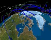
5 GSDI and related standards will serve tomorrow as a common language of high-tech communications, cuttingedge science, and international commerce and create the digital earth
6 2. The Digital Northern Jutland A county in Denmark 0,5 mio inhab. A wide-range governmental program to raise a digital region using informationtechnology on all levels. Partnership between private sector, local and regional authorities and Government Running from 2000 to 2005


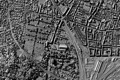
7 Arial Photos 1960 Satellites 1970

8 Digital Elevation Models 1980
9

10
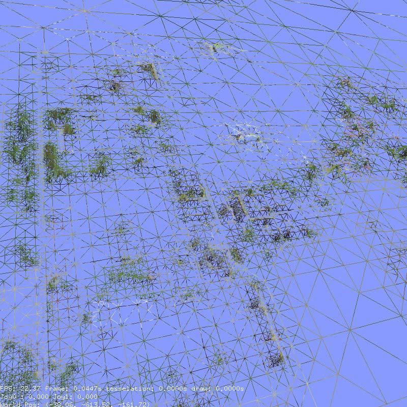
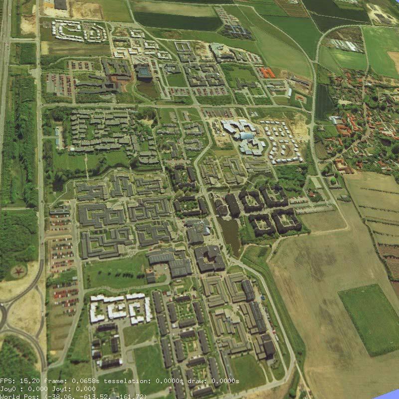
11 The University Campus in Aalborg
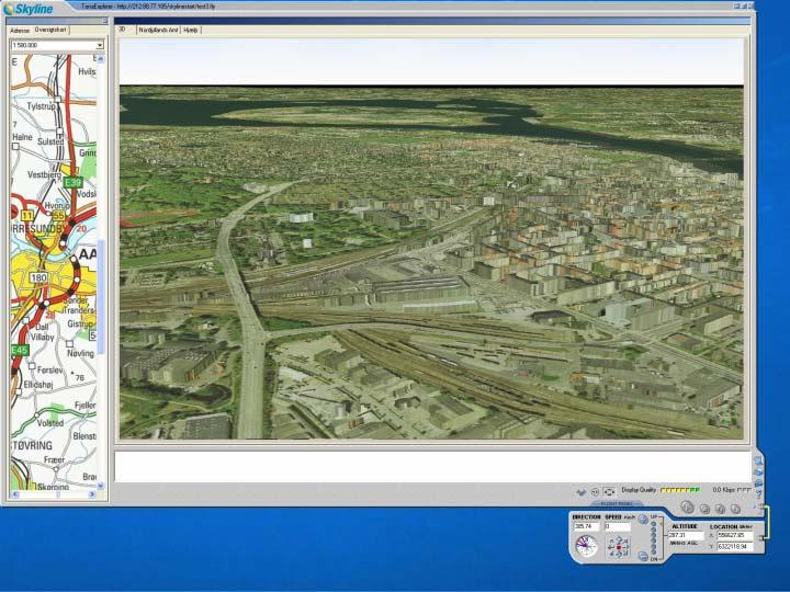
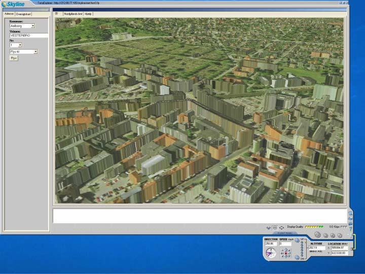
12 You re welcome to visit the Region of Northern Jutland and navigate your selv over a simple 3D visualization covering the entire region Take a look at

13
14
15

16 To se the model on Internet:


17 Planning and Desicion Making in VR-MediaLab Aalborg Local Planning for Suburbs


18 Planning and Desicion Making in VR-MediaLab Aalborg MusicHouse on The Harbour Front of Aalborg
19 Planning and Desicion Making Using the WEB New high-way passing green areas
20 Planning and Desicion Making Using the WEB New high-way passing green areas

21 Planning and Desicion Making Using the WEB New high-way passing green areas

22 Municipal Landuseplan fully available on the WEB
23 Municipal Landuseplan fully available on the WEB
24 Municipal Landuseplan fully available on the WEB
25 Municipal Landuseplan fully available on the WEB
26 3. Centre for 3D Geoinformation Partnership between University, industry (COWI and Informi GIS) and National Mapping Agency (KMS) Focus on remodelling spatial information to meet the challenge of working in 3Dspaces in full digital integrated enviroment

27 PURPOSE OF THE CENTRE FOR 3D GEOINFORMATION knowledge and competence in creating 3D models of cities and landscapes This will be done by: Focus on VR and three-dimensional urban and rural models VR user interface for looking for position-fixed information in the northern part of Jutland creating a geographical model of North Jutland developing a basis for the use of a geographical communication on realtime monitoring geospatial databases forming the basis for future research and regional knowledge within location-based services and augmented reality.
28 Futural digital environments for geoinformation Digital Elevation Models Orthofotos Cadastral Map Topografic Objects OIS OIS OIS Thematic databases Updating 3D Database User-oriented devices: - Mass-market PDA a.o. -Stratic analysis Workstation DB Streaming 3D objectoriented Database - Operating level Flowcontrol

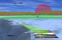
29 Navigating in in 3D-Augmented Reality seeing non-visible boarder lines
30 Datamodel 1(3) alarming complexity not only be described through points, lines or polygons with well-defined mutual relations. When objects are to be described with a spatial geometry and representation, it does not only require some new thinking, especially when the objects are to be used in connection with a GIS. Experienced in spatial models in connection with 3D visualizations, 3D animations and latest virtual reality for several decades. Still an enormous jump from simple 3D modeling to a 3D model containing knowledge about itself and relations to its surroundings.
31 Datamodel 2(3) simplify the model, and make a choice about the detail level of the object description. it is relatively simple to take a position. If for example we take a building, we have to decide how many details we wish to include. Is every roof window or windbreak to be included? existing map products and registers, which among other things contain information about the spatial extent of the objects. The problem in using different sources of information may be often be that there is conflicting information describing the object with different values.
32 Datamodel 3(3) special focus on spatial legal objects. This subject is for cadastral surveyors of great importance, because the technology is near to ready for modeling objects in real 3D. The 3D technologies based on Virtual Reality will made it possible to describe ownership to spatial legal object as there are understood in reality, where property rights always is related to three dimension. Ownership to land, buildings, easements, rights to pass (road) is all in three dimensions i in the real world. The challenge is not only to develop theoretical concepts for describing the model, but also develop procedures for object-oriented updating and real-time visualizations in virtual environments.
33 Actual ongoing research in 3DGI Organized as a number of projects that cause prototypes, algorithms and documents for the final system structure, system. The following are ongiong: Feature extraction from aerial scanning (LIDAR) Organizing 3D object representation using XML-based standards Data modeling and queries for 3D geographical data 3D cadastre Qualification of 3D geovisualization Ground laser scanning and modeling 3D objects Exchange of data between XML and RDBS Landscape visualization in 3D and temporal analysis The coming year will give rise to further projects based on partnerships between research and companies in the private sector.
34 4. Global drivers effecting the GI ( and FIG) community Datamodel Needs Available Technology
35 Global drivers effecting the GI (-FIG) commuty


")
36 GSDI INSPIRE NSDI Global drivers effecting the GI (-FIG) commuty
37 Standards for Scalable Vector Graphics Standards for 2&3D Virtuel Environments and GeoVisualization GMXL XML= standard for WEBcommunication Global drivers effecting the GI (-FIG) commuty


38 Global drivers effecting the GI (-FIG) commuty


")
39 Pervasive computing Small Mobile Portable Embedded Global drivers effecting the GI (-FIG) commuty g 4.G 5.G
40 Defence Entertainment Global drivers effecting the GI (-FIG) commuty
41 Computers will be scalabale, interoperateable and networked from portable to big servers Speeds and Capacity thousands times faster and bigger within few years Internet Protocol version 6 and more Global drivers effecting the GI (-FIG) commuty


")
42 Modelling and Dynamic 3D visualization Global drivers effecting the GI (-FIG) commuty


43 Nature Risks, Homeland Security and Intelligence Global drivers effecting the GI (-FIG) commuty

")
44 Modelling Human Activity Global drivers effecting the GI (-FIG) commuty
45
46 Links: Videnscenter for 3D GeoInformation () Research Team GeoInformation og Medieteknolgi ( and Researchcentre Forest & Landscape ( and partners: COWI ( Kort- og Matrikelstyrelsen ( Informi GIS (
Centre for 3D GeoInformation - Towards a New Concept for Handling Geoinformation
 Centre for 3D GeoInformation - Towards a New Concept for Handling Geoinformation Lars BODUM and Esben MUNK SØRENSEN, Denmark Keywords: Professional Challenges, data model, 3D objects, land information,
Global Geospatial Information Management Country Report Finland. Submitted by Director General Jarmo Ratia, National Land Survey
 Global Geospatial Information Management Country Report Finland Submitted by Director General Jarmo Ratia, National Land Survey Global Geospatial Information Management Country Report Finland Background
Techniques for Science Teachers: Using GIS in Science Classrooms.
 Techniques for Science Teachers: Using GIS in Science Classrooms. After ESRI, 2008 GIS A Geographic Information System A collection of computer hardware, software, and geographic data used together for
Open spatial data infrastructure
 Open spatial data infrastructure a backbone for digital government Thorben Hansen Geomatikkdagene 2018 Stavanger 13.-15. mars Spatial Data Infrastructure definition the technology, policies, standards,
Innovation. The Push and Pull at ESRI. September Kevin Daugherty Cadastral/Land Records Industry Solutions Manager
 Innovation The Push and Pull at ESRI September 2004 Kevin Daugherty Cadastral/Land Records Industry Solutions Manager The Push and The Pull The Push is the information technology that drives research and
Your web browser (Safari 7) is out of date. For more security, comfort and. the best experience on this site: Update your browser Ignore
 is out of date. For more security, comfort and. the best experience on this site: Update your browser Ignore") Your web browser (Safari 7) is out of date. For more security, comfort and Activityengage the best experience on this site: Update your browser Ignore Introduction to GIS What is a geographic information
Your web browser (Safari 7) is out of date. For more security, comfort and Activityengage the best experience on this site: Update your browser Ignore Introduction to GIS What is a geographic information
Chapter 10: The Future of GIS Why Speculate? 10.2 Future Data 10.3 Future Hardware 10.4 Future Software 10.5 Some Future Issues and Problems
 Chapter 10: The Future of GIS 10.1 Why Speculate? 10.2 Future Data 10.3 Future Hardware 10.4 Future Software 10.5 Some Future Issues and Problems Theme of the Course GIS's place in understanding geographic
Building a National Data Repository
 Building a National Data Repository Mladen Stojic, Vice President - Geospatial 1/30/2013 2012 Intergraph Corporation 1 Information has meaning and gives power only when shared and distributed. Information,
Brazil Paper for the. Second Preparatory Meeting of the Proposed United Nations Committee of Experts on Global Geographic Information Management
 Brazil Paper for the Second Preparatory Meeting of the Proposed United Nations Committee of Experts on Global Geographic Information Management on Data Integration Introduction The quick development of
NSDI Policy Framework of Japan - Roles of the Private Sector in SDI -
 NSDI Policy Framework of Japan - Roles of the Private Sector in SDI - Hiroshi Murakami (GSI) Geospatial World Forum 2012 Amsterdam Background Survey Act (1949) mandates the (GSI) to develop and provide
Innovation in Land Management: Integrated Solutions For National Cadastre Projects
 Success With GIS Innovation in Land Management: Integrated Solutions For National Cadastre Projects XXIII International FIG Congress Munich These documents are only complete, when used in connection with
for Effective Land Administration
 Role of Geospatial Technology in Land Information System(LIS) for Effective Land Administration Dr. Deb Jyoti Pal Sections Role of GIS in Land Records Proposed Work Flow Case Studies Role of GIS Creating
A Technique for Importing Shapefile to Mobile Device in a Distributed System Environment.
 A Technique for Importing Shapefile to Mobile Device in a Distributed System Environment. 1 Manish Srivastava, 2 Atul Verma, 3 Kanika Gupta 1 Academy of Business Engineering and Sciences,Ghaziabad, 201001,India
ENV208/ENV508 Applied GIS. Week 1: What is GIS?
 ENV208/ENV508 Applied GIS Week 1: What is GIS? 1 WHAT IS GIS? A GIS integrates hardware, software, and data for capturing, managing, analyzing, and displaying all forms of geographically referenced information.
Data Aggregation with InfraWorks and ArcGIS for Visualization, Analysis, and Planning
 Data Aggregation with InfraWorks and ArcGIS for Visualization, Analysis, and Planning Stephen Brockwell President, Brockwell IT Consulting, Inc. Join the conversation #AU2017 KEYWORD Class Summary Silos
Better Topographic Map Production Using ArcGIS. A Comprehensive Solution for Mapping Organizations
 Better Topographic Map Production Using ArcGIS A Comprehensive Solution for Mapping Organizations The World Is Always Changing As a member of a national mapping organization, you know this is true. You
Cartographic and Geospatial Futures
 Cartographic and Geospatial Futures 1. Web Cartography, WebGIS, & Virtual Globes--New Roles for Maps, GIS, and GIS professionals 2. Map Mashups, the Neo Neo-geography Movement, & Crowd-sourcing Geospatial
Norwegian spatial data infrastructure supporting disaster risk management Norwegian Mapping Authority
 Norwegian spatial data infrastructure supporting disaster risk management Norwegian Mapping Authority Arvid Lillethun, Norwegian Mapping Authority Land and Poverty 2018 Conference, World Bank 19.-23. March
GEOMATICS. Shaping our world. A company of
 GEOMATICS Shaping our world A company of OUR EXPERTISE Geomatics Geomatics plays a mayor role in hydropower, land and water resources, urban development, transport & mobility, renewable energy, and infrastructure
FIG Views of GIS and NSDI
 FIG VIEWS OF GIS AND NSDI Jes RYTTERSGAARD and Jerome C. IVES, The International Federation of Surveyors (FIG) INTRODUCTION In a few years no one will think of spatial data as something special. Spatial
Sustainable and Harmonised Development for Smart Cities The Role of Geospatial Reference Data. Peter Creuzer
 Sustainable and Harmonised Development for Smart Cities The Role of Geospatial Reference Data Peter Creuzer 1. Introduction - Smart Cities and Geodata 2. Geodata in Germany 3. Examples 4. Data and Service
THE NEW CHALLENGES FOR THE HIGHER EDUCATION OF GEODESY IN UACEG SOFIA
 THE NEW CHALLENGES FOR THE HIGHER EDUCATION OF GEODESY IN UACEG SOFIA Ivan Kunchev University of Architecture, Civil Engineering and Geodesy, 1 Hristo Smirnenski Blvd., Sofia 1046, Bulgaria Abstract Report
GEOVEKST A Norwegian Program for Cost Sharing in Production, Updating and Administration of Geographic Data
 GEOVEKST A Norwegian Program for Cost Sharing in Production, Updating and Administration of Dr. Anne Kirsten S. HØSTMARK, Norway Key words: Mapping in large scale, formal co-operation, cost sharing, standarised
Basics of GIS reviewed
 Basics of GIS reviewed Martin Breunig Karlsruhe Institute of Technology martin.breunig@kit.edu GEODETIC INSTITUTE, DEPARTMENT OF CIVIL ENGINEERING, GEO AND ENVIRONMENTAL SCIENCES, CHAIR IN GEOINFORMATICS
SOLUTIONS ADVANCED GIS. TekMindz are developing innovative solutions that integrate geographic information with niche business applications.
 ADVANCED GIS SOLUTIONS TekMindz are developing innovative solutions that integrate geographic information with niche business applications. TEK INDZ TM GIS Services Overview At the leading edge of geospatial
ISO Series Standards in a Model Driven Architecture for Landmanagement. Jürgen Ebbinghaus, AED-SICAD
 ISO 19100 Series Standards in a Model Driven Architecture for Landmanagement Jürgen Ebbinghaus, AED-SICAD 29.10.2003 The Company 100% SIEMENS PTD SIEMENS Business Services Shareholder & Strategic Business
2011 Oracle Spatial Excellence Awards Presentation
 2011 Oracle Spatial Excellence Awards Presentation May 19, 2011 Ronald Reagan Building and International Trade Center Washington, DC USA Thanks to our sponsors Media Sponsor Media Participants Media Sponsor
UTAH S STATEWIDE GEOGRAPHIC INFORMATION DATABASE
 UTAH S STATEWIDE GEOGRAPHIC INFORMATION DATABASE Data Information and Knowledge Management NASCIO Awards 2009 STATE GEOGRAPHIC INFORMATION DATABASE B. EXECUTIVE SUMMARY Utah has developed one of the most
Teaching GIS for Land Surveying
 Teaching GIS for Land Surveying Zhanjing (John) Yu Evergreen Valley College, San Jose, California James Crossfield California State University at Fresno, Fresno California 7/13/2006 1 Outline of the Presentation
Development of a Dainish infrastructure for spatial information (DAISI) Brande-Lavridsen, Hanne; Jensen, Bent Hulegaard
 Brande-Lavridsen, Hanne; Jensen, Bent Hulegaard") Aalborg Universitet Development of a Dainish infrastructure for spatial information (DAISI) Brande-Lavridsen, Hanne; Jensen, Bent Hulegaard Published in: NORDGI : Nordic Geographic Information Publication
Aalborg Universitet Development of a Dainish infrastructure for spatial information (DAISI) Brande-Lavridsen, Hanne; Jensen, Bent Hulegaard Published in: NORDGI : Nordic Geographic Information Publication
CPSC 695. Future of GIS. Marina L. Gavrilova
 CPSC 695 Future of GIS Marina L. Gavrilova The future of GIS Overview What is GIS now How GIS was viewed before Current trends and developments Future directions of research What is GIS? Internet's definition
Display data in a map-like format so that geographic patterns and interrelationships are visible
 Vilmaliz Rodríguez Guzmán M.S. Student, Department of Geology University of Puerto Rico at Mayagüez Remote Sensing and Geographic Information Systems (GIS) Reference: James B. Campbell. Introduction to
Surveyors and GIS Geeks What we need to know. Alyssa Martin, GISP, LEED BD+C AP, Nathan Wysocki
 Surveyors and GIS Geeks What we need to know Alyssa Martin, GISP, LEED BD+C AP, Nathan Wysocki Adversarial Relationship? Some sources Tension between surveying and GIS: A growing challenge Connecting the
GEOGRAPHIC INFORMATION SYSTEMS Session 8
 GEOGRAPHIC INFORMATION SYSTEMS Session 8 Introduction Geography underpins all activities associated with a census Census geography is essential to plan and manage fieldwork as well as to report results
Features and Benefits
 Autodesk LandXplorer Features and Benefits Use the Autodesk LandXplorer software family to help improve decision making, lower costs, view and share changes, and avoid the expense of creating physical
FUTURE DATA. Future data Future hardware Future software Future issues. Getting Started With GIS. Chapter 10
 THE FUTURE OF GIS Getting Started With GIS Chapter 10 GIS Futures Future data Future hardware Future software Future issues Dursun Z. ªeker Theme of the book GIS's place in understanding geographic distributions
Evaluating e-government : implementing GIS services in Municipality
 Evaluating e-government : implementing GIS services in Municipality Municipality of Thessaloniki - G.I.S. Unit Misirloglou Symeon Head of the GIS Unit ESRI UC - 2016 The GIS Section - subset of the department
July 5-6, 2010 Mytilene, Greece
 Web GIS platform for forest fire management Prof. Kostas Kalabokidis Principal Investigator Univ. of the Aegean, Dept. of Geography, Greece Prof. George Kallos Univ. of Athens, Dept. of Physics, Greece
Services.
 1 Transport Analysis & Modeling Over the course of a decade, Masterconcept has gained a wide range of experience in the field of transport master planning, with a special emphasis on regional and urban
Corporate. Information. Railway Infrastructure Administrator. Year indracompany.com
 geospatial and mobility Corporate Geographic Information System of ADIF Railway Infrastructure Administrator. Year 2009-2010 Corporate Geographic Information System of ADIF ADIF. Spanish Administrator
Virtual 3D Models as a Basis for Property Formation
 Virtual 3D Models as a Basis for Property Formation Martin ANDRÈE,Goran MILUTINOVIC and Stefan SEIPEL, Sweden Key words: LIDAR, 3D, Cadastre, Survey, e-government, process development SUMMARY Property
STATE GEOGRAPHIC INFORMATION DATABASE
 STATE GEOGRAPHIC INFORMATION DATABASE Data Information and Knowledge Management STATE GEOGRAPHIC INFORMATION DATABASE EXECUTIVE SUMMARY Utah has developed one of the most comprehensive statewide GIS resources
geographic patterns and processes are captured and represented using computer technologies
 Proposed Certificate in Geographic Information Science Department of Geographical and Sustainability Sciences Submitted: November 9, 2016 Geographic information systems (GIS) capture the complex spatial
GIS Building Communities beyond National Borders (Building Successful Spatial Data Infrastructures) Nick Land, ESRI Europe
 Nick Land, ESRI Europe") GIS Building Communities beyond National Borders (Building Successful Spatial Data Infrastructures) Nick Land, ESRI Europe UK worst flooding in the last 60 years 350,000 households without drinking water
GIS Building Communities beyond National Borders (Building Successful Spatial Data Infrastructures) Nick Land, ESRI Europe UK worst flooding in the last 60 years 350,000 households without drinking water
Esri and GIS Education
 Esri and GIS Education Organizations Esri Users 1,200 National Government Agencies 11,500 States & Regional Agencies 30,800 Cities & Local Governments 32,000 Businesses 8,500 Utilities 12,600 NGOs 11,000
Building a national spatial data infrastructure. Thorben Hansen, Head of Division Danish Agency for Data Supply and Efficiency
 Building a national spatial data infrastructure Thorben Hansen, Head of Division Danish Agency for Data Supply and Efficiency About Spatial Data Infrastructure Spatial data come from many sources and is
GIS-based Smart Campus System using 3D Modeling
 GIS-based Smart Campus System using 3D Modeling Smita Sengupta GISE Advance Research Lab. IIT Bombay, Powai Mumbai 400 076, India smitas@cse.iitb.ac.in Concept of Smart Campus System Overview of IITB Campus
ESRI Survey Summit August Clint Brown Director of ESRI Software Products
 ESRI Survey Summit August 2006 Clint Brown Director of ESRI Software Products Cadastral Fabric How does Cadastral fit with Survey? Surveyors process raw field observations Survey measurements define high-order
Themes for Geomatics Conference. Geodesy Themes
 Themes for Geomatics Conference Geodesy Themes Geodynamics o Modeling the Deformation of the Earth s Crust o Recent Advances in Geometric Approaches to Deformation Analysis o Monitoring Systems (Sensors
State of Israel Ministry of Housing and Construction Survey of Israel. The Hydrological project case
 State of Israel Ministry of Housing and Construction Survey of Israel The Hydrological project case Survey of Israel Content Introduction To the Survey of Israel The operation assumptions The main responsibilities
Establishing the National Spatial Data Infrastructure (NSDI) for Norway a joint effort by many stakeholders SPATIAL DATA FOR BENEFIT OF THE SOCIETY
 for Norway a joint effort by many stakeholders SPATIAL DATA FOR BENEFIT OF THE SOCIETY") Establishing the National Spatial Data Infrastructure (NSDI) for Norway a joint effort by many stakeholders SPATIAL DATA FOR THE BENEFIT OF SOCIETY OUTLINE Political background Norway digital - The Norwegian
Establishing the National Spatial Data Infrastructure (NSDI) for Norway a joint effort by many stakeholders SPATIAL DATA FOR THE BENEFIT OF SOCIETY OUTLINE Political background Norway digital - The Norwegian
Experiences and Directions in National Portals"
 FIG Seminar on e-land Administration Innsbruck/Austria 2-4 June 2004 "ESRI's Experiences and Directions in National Portals" Kevin Daugherty Cadastral/Land Records Manager ESRI Topic Points Technology
Business Model for sustainable regional development by tourism
 Business Model for sustainable regional development by tourism Why EuroVeloPark Banat? Steps to Success Action proposal 1. Drawing of the Basis Map 2. Data Acquisition, POIs, etc. 3. Printed Map and Distribution
ASSESSMENT. Industry Solutions Harness the Power of GIS for Property Assessment
 ASSESSMENT Industry Solutions Harness the Power of GIS for Property Assessment Esri Canada has thousands of customers worldwide who are using the transforming power of GIS technology to collect, maintain,
GIS From Storing to Sharing. Esben Munk Sørensen
 GIS From Storing to Sharing Esben Munk Sørensen ems@land.aau.dk Aalborg University Department of Planning (www.plan.aau.dk) Innovative Fishery Management plus Geoinformation and Land Management = Blue
IRDAT Fvg, evolving a regional Spatial Data Infrastructure according to INSPIRE
 IRDAT Fvg, evolving a regional Spatial Data Infrastructure according to INSPIRE Tutti i diritti riservati. Proprietà INSIEL SpA. A. Benvenuti, A. Chiarandini Insiel (Italy) M. Lunardis - Friuli Venezia
Land Administration and Cadastre
 Geomatics play a major role in hydropower, land and water resources and other infrastructure projects. Lahmeyer International s (LI) worldwide projects require a wide range of approaches to the integration
THE USE OF GEOMATICS IN CULTURAL HERITAGE AND ARCHAEOLOGY FOR VARIOUS PURPOSES
 THE USE OF GEOMATICS IN CULTURAL HERITAGE AND ARCHAEOLOGY FOR VARIOUS PURPOSES FEBRUARY 2013 AL BEIDA GEOPLAN CONTENT Company Profile Concept Objectives and Strategies Data Production Methods Data Samples
Web Visualization of Geo-Spatial Data using SVG and VRML/X3D
 Web Visualization of Geo-Spatial Data using SVG and VRML/X3D Jianghui Ying Falls Church, VA 22043, USA jying@vt.edu Denis Gračanin Blacksburg, VA 24061, USA gracanin@vt.edu Chang-Tien Lu Falls Church,
8/27/2015 M. Helper, U. Texas, Austin
 Slide 1 What is GIS? Geology Transportation Hydrography Elevation Imagery Geo327G/386G UT Austin 1 Slide 2 Key Questions and Issues What is GIS? What are the applications of GIS? How is the real world
EuroSDR (European Spatial Data Research)
") EuroSDR (European Spatial Data Research) ROLLING RESEARCH PLAN 2015-2018 EuroSDR Secretariat Public Governance Institute KU Leuven Parkstraat 45 bus 3609 3000 Leuven Belgium Tel.: +32 16 32 31 80 Fax:
EuroSDR (European Spatial Data Research) ROLLING RESEARCH PLAN 2015-2018 EuroSDR Secretariat Public Governance Institute KU Leuven Parkstraat 45 bus 3609 3000 Leuven Belgium Tel.: +32 16 32 31 80 Fax:
GIS = Geographic Information Systems;
 What is GIS GIS = Geographic Information Systems; What Information are we talking about? Information about anything that has a place (e.g. locations of features, address of people) on Earth s surface,
Developing 3D Geoportal for Wilayah Persekutuan Iskandar
 Developing 3D Geoportal for Wilayah Persekutuan Iskandar Dionnald Beh BoonHeng and Alias Abdul Rahman Department of Geoinformatics, Faculty of Geoinformation Engineering and Sciences, Universiti Teknologi
Esri s Living Atlas of the World Community Maps
 Esri s Living Atlas of the World Community Maps Seth Sarakaitis Wednesday May 7, 2014 ArcGIS Living Atlas Concept Living Atlas Content Tour Contributing to the Living Atlas (Community Maps) Seth Sarakaitis
Key Questions and Issues. What is GIS? GIS is to geographic analysis as: What is GIS? 9/3/2013. GEO 327G/386G, UT Austin 1
 What is GIS? Key Questions and Issues Geology Elevation Transportation Hydrography Imagery What is GIS? What are the applications of GIS? How is the real world represented in GIS? What analyses can GIS
GIS Geographical Information Systems. GIS Management
 GIS Geographical Information Systems GIS Management Difficulties on establishing a GIS Funding GIS Determining Project Standards Data Gathering Map Development Recruiting GIS Professionals Educating Staff
European Spatial Data Research. EuroSDR. Prof. Dr. Ir. Joep Crompvoets. General Assembly CLGE Tirana 18 March
 EuroSDR Prof. Dr. Ir. Joep Crompvoets General Assembly CLGE - 2016 Tirana 18 March 2016 INTRODUCTORY QUESTIONS Who knows what is EuroSDR? Who does NOT know what is EuroSDR? Who is employed at mapping agencies?
Spatial Data Infrastructure Concepts and Components. Douglas Nebert U.S. Federal Geographic Data Committee Secretariat
 Spatial Data Infrastructure Concepts and Components Douglas Nebert U.S. Federal Geographic Data Committee Secretariat August 2009 What is a Spatial Data Infrastructure (SDI)? The SDI provides a basis for
Bentley Map Advancing GIS for the World s Infrastructure
 Bentley Map Advancing GIS for the World s Infrastructure Presentation Overview Why would you need Bentley Map? What is Bentley Map? Where is Bentley Map Used? Red text signifies new things in Bentley Map
GSDI Global Spatial Data Infrastructure. Convergences between Geo Spatial Communities: key decision for decision making
 GSDI Global Spatial Data Infrastructure Convergences between Geo Spatial Communities: key decision for decision making April 14 th 2010 Bas Kok GSDI Past-President Director of International Affairs, Dutch
Disaster Management & Recovery Framework: The Surveyors Response
 Disaster Management & Recovery Framework: The Surveyors Response Greg Scott Inter-Regional Advisor Global Geospatial Information Management United Nations Statistics Division Department of Economic and
Geometric Algorithms in GIS
 Geometric Algorithms in GIS GIS Visualization Software Dr. M. Gavrilova GIS Software for Visualization ArcView GEO/SQL Digital Atmosphere AutoDesk Visual_Data GeoMedia GeoExpress CAVE? Visualization in
Lecture 11. Data Standards and Quality & New Developments in GIS
 Lecture 11 Data Standards and Quality & New Developments in GIS Lecture 11: Outline I. Data Standards and Quality 1. Types of Spatial Data Standards 2. Data Accuracy II. New Developments/The Future of
Utah UIC Geospatial Integration EIEN Project
 Utah UIC Geospatial Integration EIEN Project ESRI UC, June 2007 Bert Granberg Utah Automated Geographic Reference Center Utah Automated Geographic Reference Center (AGRC) AGRC Responsibilities Facilitate
CARTOGRAPHY in a Web World
 CARTOGRAPHY in a Web World SENSE Research Cluster XIII meeting: Concepts and tools for spatial data visualization BAREND KÖBBEN kobben@itc.nl b.j.kobben@utwente.nl Agenda Short introduction to ITC and
Jim Fox. copyright UNC Asheville's NEMAC
 Decisions and System Thinking Jim Fox November, 2012 1 UNC Asheville s s NEMAC National Environmental Modeling and Analysis Center Applied Research and technology development on integration of environmental
Trimble s ecognition Product Suite
 Trimble s ecognition Product Suite Dr. Waldemar Krebs October 2010 Trimble Geospatial in the Image Processing Chain Data Acquisition Pre-processing Manual/Pixel-based Object-/contextbased Interpretation
Geographical Information System GIS
 Geographical Information System GIS LOOM.02.331 anto.aasa@ut.ee Scale GIS and spatial planning National Regional Local Strategic (National Dev. Plan) National Goals and development policy Tactical (Regional
DATA SOURCES AND INPUT IN GIS. By Prof. A. Balasubramanian Centre for Advanced Studies in Earth Science, University of Mysore, Mysore
 DATA SOURCES AND INPUT IN GIS By Prof. A. Balasubramanian Centre for Advanced Studies in Earth Science, University of Mysore, Mysore 1 1. GIS stands for 'Geographic Information System'. It is a computer-based
Project based approach developing National Spatial Data Infrastructure in Lithuania
 Project based approach developing National Spatial Data Infrastructure in Lithuania National Land Service under the Ministry of Agriculture of The Republic of Lithuania Cadastres & Geodesy Department Director
The Application of 3D Web GIS In Land Administration - 3D Building Model System
 The Application of 3D Web GIS In Land Administration - 3D Building Model System Hui-Wen Chen *, Wen-Yuan Ku *, Lan-Kun Chung *, Tien-Yin Chou *, Li-Min Yi2 ** * Feng Chia University, Taiwan, ** Land Department
Implementation of Inspire in Denmark - How we get it flying! Olav Eggers National Survey & Cadastre -Denmark
 Implementation of Inspire in Denmark - How we get it flying! Olav Eggers oe@kms.dk National Survey & Cadastre -Denmark Introduction Overview Infrastructure for Spatial Information Act National Survey and
Manual of Digital Earth
 V8.0 March 27, 2018 International Society for Digital Earth Manual of Digital Earth (Tentative Title) OUTLINE Foreword Chapter 1 Understanding Digital Earth 1.1 Origins and Precursors of Digital Earth
Are You Maximizing The Value Of All Your Data?
 Are You Maximizing The Value Of All Your Data? Using The SAS Bridge for ESRI With ArcGIS Business Analyst In A Retail Market Analysis SAS and ESRI: Bringing GIS Mapping and SAS Data Together Presented
Large Scale Mapping Policy for the Province of Nova Scotia
 Large Scale Mapping Policy for the Province of Nova Scotia December, 2005 Version 1.0 TABLE OF CONTENTS PAGE BACKGROUND...3 POLICY...5 Policy 1.0 Large Scale Mapping Program...5 Policy 2.0 Service Offering...5
NATIONAL BENEFITS OF INSPIRE IMPLEMENTATION THE REAL LIFE USE CASES
 NATIONAL BENEFITS OF INSPIRE IMPLEMENTATION THE REAL LIFE USE CASES Andrius Balciunas, SE GIS Centras, a.balciunas@gis centras.lt Evaldas Rozanskas, SE GIS Centras, e.rozanskas@gis centras.lt INSPIRE conference
Spatial Statistical Information Services in KOSTAT
 Distr. GENERAL WP.30 12 April 2010 ENGLISH ONLY UNITED NATIONS ECONOMIC COMMISSION FOR EUROPE (UNECE) CONFERENCE OF EUROPEAN STATISTICIANS EUROPEAN COMMISSION STATISTICAL OFFICE OF THE EUROPEAN UNION (EUROSTAT)
To: Ross Martin, Lisa Stapleton From: Brad Lind Subject: Joint Funding Agreement with USGS for 2012 Imagery Date: March 14, 2012.
 To: Ross Martin, Lisa Stapleton From: Brad Lind Subject: Joint Funding Agreement with USGS for 2012 Imagery Date: March 14, 2012 Attached are two copies of the Joint Funding Agreement (JFA) between SanGIS
SDI Standards at work
 SDI Standards at work Jan Juul Jensen Senior Technology Strategist Informi GIS Denmark Informi GIS Private held Limited Company Specialized in GIS 100+ employees HQ in Charlottenlund, Copenhagen Regional
Using MAGIC to Access Spatial Imagery: Putting ER Mapper Image Web Server, ArcIMS and MrSID to work in your Library
 Using MAGIC to Access Spatial Imagery: Putting ER Mapper Image Web Server, ArcIMS and MrSID to work in your Library Patrick McGlamery Shirley Quintero University of Connecticut Libraries Building the Connecticut
Towards National Geographic Information System in Nepal
 2 nd High Level Forum on Global Geospatial Information Management, Qatar National Convention Centre, Doha, Qatar, 4 6 February, 2013 Towards National Geographic Information System in Nepal Krishna Raj
Combining Geospatial and Statistical Data for Analysis & Dissemination
 Combining Geospatial and Statistical Data for Analysis & Dissemination (with Special Reference to Qatar Census 2010) Presentation by Mansoor Al Malki, Director of IT Department Qatar Statistics Authority
Emerging Trends in Institutional Arrangements Europe - Finland
 Emerging Trends in Institutional Arrangements Europe - Finland Arvo Kokkonen Deputy Director General National Land Survey of Finland 1 Contents Facts about Finland National Land Survey of Finland European
Voices from Private Sector: Insights for Future NSDI Development in Indonesia
 Voices from Private Sector: Insights for Future NSDI Development in Indonesia Ta n d a n g Yu l i a d i D w i P u t ra, Ryosuke S h i b a s a k i I n st i t u t e o f I n d u st r i a l S c i e n c e,
How GIS can be used for improvement of literacy and CE programmes
 How GIS can be used for improvement of literacy and CE programmes Training Workshop for Myanmar Literacy Resource Center (MLRC) ( Yangon, Myanmar, 11 20 October 2000 ) Presented by U THEIN HTUT GEOCOMP
USING GIS CARTOGRAPHIC MODELING TO ANALYSIS SPATIAL DISTRIBUTION OF LANDSLIDE SENSITIVE AREAS IN YANGMINGSHAN NATIONAL PARK, TAIWAN
 CO-145 USING GIS CARTOGRAPHIC MODELING TO ANALYSIS SPATIAL DISTRIBUTION OF LANDSLIDE SENSITIVE AREAS IN YANGMINGSHAN NATIONAL PARK, TAIWAN DING Y.C. Chinese Culture University., TAIPEI, TAIWAN, PROVINCE
Paper UC1351. Conference: User Conference Date: 08/10/2006 Time: 8:30am-9:45am Room: Room 23-B (SDCC)
") Conference: User Conference Date: 08/10/2006 Time: 8:30am-9:45am Room: Room 23-B (SDCC) Title of Paper: Increasing the Use of GIS in the Federal Government Author Name: Miss Abstract This presentation
Conference: User Conference Date: 08/10/2006 Time: 8:30am-9:45am Room: Room 23-B (SDCC) Title of Paper: Increasing the Use of GIS in the Federal Government Author Name: Miss Abstract This presentation
GIS and Community Health. GIS and Community Health. Institutional Context and Interests in GIS Development. GIS and Community Health
 GIS and Community Health GIS and Community Health Some critiques of GIS emphasize the potentially harmful social consequences of the diffusion of GIS technology, including reinforcing the power of state
User Requirements Gathering for a National 3D Mapping Product in the United Kingdom
 User Requirements Gathering for a National 3D Mapping Product in the United Kingdom Session 4 EuroSDR/VOLTA SESSION: NMCAS I (3D GEOINFORMATION FOR NATIONAL AND CADASTRAL MAPPING AGENCIES I) th 13 3DGeoInfo
Emergency Planning. for the. Democratic National. Convention. imaging notes // Spring 2009 //
 Emergency Planning for the Democratic National Convention The DRAPP Demonstrates Partnership among Local, Regional, State, Utility and Federal Governments 14 imaging notes // Spring 2009 // www.imagingnotes.com