Multiple Representations of Geospatial Data: A Cartographic Search for the Holy Grail
|
|
|
- Beryl O’Connor’
- 5 years ago
- Views:
Transcription


1 Multiple Representations of Geospatial Data: A Cartographic Search for the Holy Grail Barbara P. Buttenfield University of Colorado, Boulder babs@colorado.edu Collaboration with Cindy Brewer, Penn State University Funding from ESRI B6345-7
2 The Holy Grail? A single, detailed cartographic database for base mapping at multiple scales and for multiple purposes Reference feature types Standard compilation scales Base Carto Focus on what s in the database

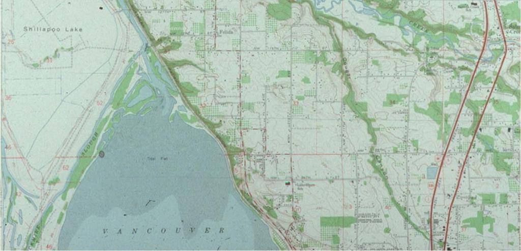
3 1:24,000 DLG data Vancouver, Wash

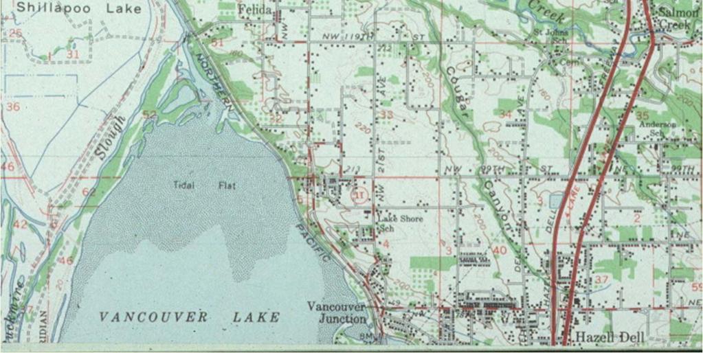
4 1:100,000 DLG data Vancouver, Wash

5 1:2,000,000 DLG data Vancouver, Wash

6 Multiple map purposes Terrain analysis Traditional topographic views

7 Multiple map purposes Town planning Infrastructure development

8 Multiple map purposes Land cover analysis Site suitability

9 Where are the gaps? 1:100,000
10 The Holy Grail? A single, detailed cartographic database for base mapping at multiple scales and for multiple purposes Regardless of continuing debate on validity of a finest grain solution No single data compilation at ultimately fine resolution is currently available Gaps in current multi-scale data sources
11 The Holy Grail? Don t disparage the data producer Data are compiled at standard scales for specific reasons and conventions Bottom line A single unified database schema does not span continuous scale range Challenges seamless multi-scale map series and data production
12 Challenges Current databases mix derived representations with original compilations through life cycle Terrain Hydrography Image Base Roads Cultural (Land Cover) Smaller Scale Boundaries PLSS Place Names Finer capture use Resolution capture use capture use Hard to distinguish data as captured from data as processed
13 Additional Challenges Database features that persist across compilation scales vary in geometry, dimensionality, attribution and singularity (city as a point or a compound object) Inconsistent database semantics problems managing data and integrating data across scales among data providers
14 A Relational Database Approach Currently, most GIS and map production systems offer only minimal software support for linked multiscale data management Linkages only on simple attributes Object IDs, ID descriptions or timestamps Insert a database from another source agency, compiled in the missing scale range Integrate data schemas Link feature types
15 A Relational Database Approach Study and compare existing federal agency map series databases Identify scale gaps for DLG this occurs ~ 1:250,000 Insert a 1:250k dataset into the DLG schema Explore discrepancies omissions, comissions, changes to semantic hierarchy Follow European cartographic work practice Capture data within Digital Landscape Models (DLM) Derive data to Digital Cartographic Models (DCM) Targeted scales and purposes


16
17


18 Digital Landscape Model Cartographic Abstraction Digital Cartographic Model Map / Atlas Products DLM 1km resolution DCM_10Million 10M World Wall Map DCM_250K 250K Road Map DCM_100K 100K Recreation Map DLM 25m resolution DCM_50K 50K Wall Map DCM_Campus25K 30K Campus DCM_Topo24K 24K DOQ 24K Hillshade 24K USGS Topo DLM 5m resolution DCM_10K 10K OS Topo
19 Smaller Scale DLM DCM data production workflow R8 R7 Key to Representations = DLM = DCM R4 R3 = Derived R5 R6 R2 R1 Many Uses Single Use
20 Smaller Scale DLM DCM data production workflow R7 R8 R3 R4 R5 R2 R1 R6 Many Uses Single Use


21 Datasets DLG Digital Line Graph (USGS) - (reference data schema) 1:24,000 1:100,000 1: 2 million VMAP - Vector Map 1:250,000 Compliant with DIGEST Standard Same schema as DCW - Digital Chart of the World Derived from hardcopy maps, many pre-1992 Developed by NIMA - Maintained by NGA Available at


22 Match feature types for ~ 90 feature classes Intention automate as much as possible

23 Extract Unique Feature Types Manual Process Open each VMAP feature class.dbf file in Excel Advanced filter isolates unique records First pass Collect combinations for ALL feature codes Compile into single spreadsheet for each feature dataset


24 VMAP Feature Type Tables Up to 5 feature code descriptions Data are clearly not in normal form
25 Schema Crosswalk Based on DLG schema at 1:24,000 Geographic rationale Cartography Feature Type ID Match feature types using CFTID, DLG description and VMAP feature descriptions Import to DLG data schema Python script attaches CFTID codes Collect unmatched feature types Revisit unmatched schema rows individually


26 CFTID table after Matching Feature Types Water course lines before import to CFTID table Water course lines after import to CFTID table


27 Unmatched Schema Rows

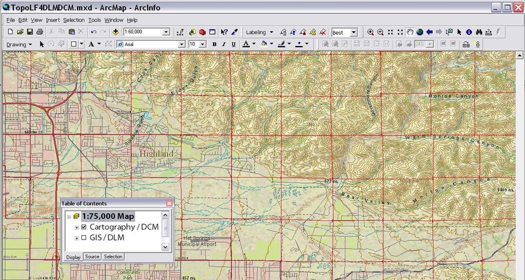
28 Summary of schema discrepancies Either VMAP DLG Three types (at least) New feature geometries Emerging feature types Changes in schema hierarchy

29 New Feature Geometries Existing feature type represented with different dimension

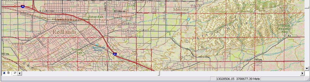
30 Emerging Feature Types Existing feature type and geometry, but VMAP feature codes more detailed than DLG schema

31 Case Study: Airport table DLG VMAP

32 Hierarchy Changes 14 April 2005 Golledge Lecture

33 Residual counts Unresolved schema entries

34 Attaching symbol libraries ESRI DLG standard symbol library GEOSYM VMAP standard symbol library Other sources


35 DLG 1:2 million source S. California Mapped at 1:2 million


36 DLG 1:2 million source San Bernadino Mapped at 1:250,000 Mapped at 1:2 million

37 DLG 1:100K source San Bernadino Mapped at 1:250,000

38 VMAP 1:250K source San Bernadino Mapped at 1:250,000


39 VMAP 1:250K source San Bernadino Mapped at 1:100,000 Mapped at 1:250,000
40 Where to go from here? Alternative symbologies e.g., other NMA symbol libraries sociopolitical exercise Multiple symbol libraries in single schema table How far can a data schema be pushed? Symbol change alone Geoprocessing alone Some combination of the two Revisit the ScaleMaster fill in the gaps

41 Mock-up for data ftp site Choose map scale 1:45,000 Find the best mix of data source scales and tell us what you see PAN
42 Summary and Discussion Extracting unique features is reasonable undertaking with limited dataset, but more automation is needed Crosswalk provides insights into diverse ontologies New geometries, emerging feature types Change in hierarchy


43 Scaleless database? 1:100,000 RF refers to a range of map scales, not a single point Scale sensitivity varies by layer and by scale range (and this bears further scrutiny)
Managing Multiple Representations of Base Carto Features: A Data Modeling Approach
 Managing Multiple Representations of Base Carto Features: A Data Modeling Approach Barbara P. Buttenfield and Torrin Hultgren Department of Geography CB-260 University of Colorado Boulder, CO 80309-0260
Aileen Buckley, Ph.D. and Charlie Frye
 An Information Model for Maps: Towards Production from GIS Databases Aileen Buckley, Ph.D. and Charlie Frye Researchers, ESRI GIS vs. cart GIS Outline of the presentation Introduction Differences between
An Information Model for Maps: Towards Cartographic Production from GIS Databases
 An Information Model for s: Towards Cartographic Production from GIS Databases Aileen Buckley, Ph.D. and Charlie Frye Senior Cartographic Researchers, ESRI Barbara Buttenfield, Ph.D. Professor, University
Multiple Representations of Geospatial Data: A Cartographic Search for the Holy Grail?
 Multiple Representations of Geospatial Data: A Cartographic Search for the Holy Grail? Barbara P. Buttenfield University of Colorado Boulder Research Faculty Affiliate, USGS-CEGIS babs@colorado.edu 13
Cartography: Modeling GIS data for Mapmaking. Aileen Buckley, Ph.D. Senior Cartographic Researcher, ESRI. Barbara Buttenfield, Ph.D.
 Slide 1 Cartography: Modeling GIS data for Mapmaking Aileen Buckley, Ph.D. Senior Cartographic Researcher, ESRI Barbara Buttenfield, Ph.D. Professor, University of Colorado-Boulder Thank you coming to
ArcGIS Data Models: Multiscale Topographic Maps. Charlie Frye Aileen Buckley
 ArcGIS Data Models: Multiscale Topographic Maps Charlie Frye Aileen Buckley Other cartography sessions ArcGIS ArcMap: Introduction to ArcMap Wed 1:30 PM, 6F ArcGIS Cartography: Map Design and Page Layout
GENERAL COMMAND OF MAPPING TURKEY
 GENERAL COMMAND OF MAPPING (HARİTA GENEL KOMUTANLIĞI) TURKEY NATIONAL REPORT (2007-2011) 15 th General Assembly International Cartographic Conference Paris FRANCE, 03-08 July 2011 NATIONAL REPORT (2007-2011)
Esri Production Mapping: Map Automation & Advanced Cartography MADHURA PHATERPEKAR JOE SHEFFIELD
 Esri Production Mapping: Map Automation & Advanced Cartography MADHURA PHATERPEKAR JOE SHEFFIELD Traditional Cartography What you really want Cartographic Workflow Output Cartographic Data Symbology Layout
Designing GIS Databases to Support Mapping and Map Production Charlie Frye, ESRI Redlands Aileen Buckley, ESRI Redlands
 Designing GIS Databases to Support Mapping and Map Production Charlie Frye, ESRI Redlands Aileen Buckley, ESRI Redlands 1 Designing GIS Databases to Support Mapping and Map Production Charlie Frye, ESRI
Place Still Matters: Generalizing the NHD by Local Terrain and Climate
 Place Still Matters: Generalizing the NHD by Local Terrain and Climate Barbara Buttenfield, Geography, CU-Boulder Cynthia Brewer, Geography, Penn State E. Lynn Usery, USGS-CEGIS Research Assistants: Chris
MODELING ACTIVE DATABASE-DRIVEN CARTOGRAPHY WITHIN GIS DATABASES
 Page 1 of 7 MODELING ACTIVE DATABASE-DRIVEN CARTOGRAPHY WITHIN GIS DATABASES Abstract Charlie Frye and Cory L. Eicher ESRI, 380 New York Street, Redlands, CA 92373 GIS databases contain classes of features
Esri Production Mapping: An Introduction
 Esri Production Mapping: An Introduction Amber Bethell & Joseph Sheffield Esri UC 2014 Technical Workshop Your organization s processes Collect Share Manage Produce Your organization s needs Standardization
Kentucky Collaborates in GeoMAPP Project: The Advantages and Challenges of Archiving in a State with a Centralized GIS
 Kentucky Collaborates in GeoMAPP Project: The Advantages and Challenges of Archiving in a State with a Centralized GIS Geospatial Multistate Archive and Preservation Partnership By Glen McAninch Best Practices
Evaluation of Map Symbols by Screen Resolution and File Format Through Scale
 Evaluation of Map Symbols by Screen Resolution and File Format Through Scale Cynthia Brewer and Chelsea Hanchett, Penn State Barbara Buttenfield, Boulder Lawrence Stanislawski, CEGIS Penn State Research
ScaleMaster characterization of types of design change through scale for mapping from multi-resolution databases
 ScaleMaster characterization of types of design change through scale for mapping from multi-resolution databases Cynthia A. Brewer, Pennsylvania State University Jessica Acosta, Penn State ESRI Barbara
Creating Basemaps to Manage Buildings and Facilities
 Esri International User Conference San Diego, California Technical Workshops July 26, 2012 Creating Basemaps to Manage Buildings and Facilities Mark Stewart and Tamara Yoder Topics for this Session Overview
Multiple Representations with Overrides, and their relationship to DLM/DCM Generalization. Paul Hardy Dan Lee
 Multiple Representations with Overrides, and their relationship to DLM/DCM Generalization Paul Hardy Dan Lee phardy@esri.com dlee@esri.com 1 Context This is a forward-looking presentation, and much of
Karsten Vennemann, Seattle. QGIS Workshop CUGOS Spring Fling 2015
 Karsten Vennemann, Seattle 2015 a very capable and flexible Desktop GIS QGIS QGIS Karsten Workshop Vennemann, Seattle slide 2 of 13 QGIS - Desktop GIS originally a GIS viewing environment QGIS for the
DATA SOURCES AND INPUT IN GIS. By Prof. A. Balasubramanian Centre for Advanced Studies in Earth Science, University of Mysore, Mysore
 DATA SOURCES AND INPUT IN GIS By Prof. A. Balasubramanian Centre for Advanced Studies in Earth Science, University of Mysore, Mysore 1 1. GIS stands for 'Geographic Information System'. It is a computer-based
Innovation. The Push and Pull at ESRI. September Kevin Daugherty Cadastral/Land Records Industry Solutions Manager
 Innovation The Push and Pull at ESRI September 2004 Kevin Daugherty Cadastral/Land Records Industry Solutions Manager The Push and The Pull The Push is the information technology that drives research and
FIRE DEPARMENT SANTA CLARA COUNTY
 DEFINITION FIRE DEPARMENT SANTA CLARA COUNTY GEOGRAPHIC INFORMATION SYSTEM (GIS) ANALYST Under the direction of the Information Technology Officer, the GIS Analyst provides geo-spatial strategic planning,
Among various open-source GIS programs, QGIS can be the best suitable option which can be used across partners for reasons outlined below.
 Comparison of Geographic Information Systems (GIS) software As of January 2018, WHO has reached an agreement with ESRI (an international supplier of GIS software) for an unlimited use of ArcGIS Desktop
Performing Advanced Cartography with Esri Production Mapping
 Esri International User Conference San Diego, California Technical Workshops July 25, 2012 Performing Advanced Cartography with Esri Production Mapping Tania Pal & Madhura Phaterpekar Agenda Outline generic
Production Line Tool Sets
 Production Line Tool Sets Tools for high-quality database production and cartographic output Production Line Tool Sets Production Line Tool Sets (PLTS) by ESRI are a collection of software applications
Performance of Map Symbol and Label Design with Format and Display Resolution Options Through Scale for The National Map
 Performance of Map Symbol and Label Design with Format and Display Resolution Options Through Scale for The National Map Cynthia A. Brewer, Pennsylvania State University Chelsea L. Hanchett, Penn State
Experiences and Directions in National Portals"
 FIG Seminar on e-land Administration Innsbruck/Austria 2-4 June 2004 "ESRI's Experiences and Directions in National Portals" Kevin Daugherty Cadastral/Land Records Manager ESRI Topic Points Technology
GED 554 IT & GIS. Lecture 6 Exercise 5. May 10, 2013
 GED 554 IT & GIS Lecture 6 Exercise 5 May 10, 2013 Free GIS data sources ******************* Mapping numerical data & Symbolization ******************* Exercise: Making maps for presentation GIS DATA SOFTWARE
Evaluating Generalizations of Hydrography in Differing Terrains for The National Map of the United States
 Evaluating Generalizations of Hydrography in Differing Terrains for The National Map of the United States Cynthia Brewer, Pennsylvania State University Barbara Buttenfield, University of Colorado Boulder
Performing Map Cartography. using Esri Production Mapping
 AGENDA Performing Map Cartography Presentation Title using Esri Production Mapping Name of Speaker Company Name Kannan Jayaraman Agenda Introduction What s New in ArcGIS 10.1 ESRI Production Mapping Mapping
A General Framework for Conflation
 A General Framework for Conflation Benjamin Adams, Linna Li, Martin Raubal, Michael F. Goodchild University of California, Santa Barbara, CA, USA Email: badams@cs.ucsb.edu, linna@geog.ucsb.edu, raubal@geog.ucsb.edu,
Mastering Map Scale: Formalizing Guidelines for Multi-Scale Map Design
 Mastering Map Scale: Formalizing Guidelines for Multi-Scale Map Design Cynthia A. Brewer Pennsylvania State University Barbara P. Buttenfield University of Colorado Boulder a.k.a. Cindy and babs Collaborators
Name NRS 509 Exam I. Right Map
 Read every question carefully. You may use a calculator if you wish. Conversion tables are provided at the end of the exam. If you have any questions, raise your hand. Be sure to show your work on computational
Multiscale Representations of Water: Tailoring Generalization Sequences to Specific Physiographic Regimes
 Multiscale Representations of Water: Tailoring Generalization Sequences to Specific Physiographic Regimes Barbara P. Buttenfield 1, Lawrence V. Stanislawski 2, Cynthia A. Brewer 3 1 Department of Geography,
June 19 Huntsville, Alabama 1
 June 19 Huntsville, Alabama 1 Real-Time Geospatial Data: The Fusion of PI and ArcGIS Enabling Smarter Facilities Management OSIsoft and Esri Mapping and Location Analytics Platform Supporting Your Use
Introduction to GIS I
 Introduction to GIS Introduction How to answer geographical questions such as follows: What is the population of a particular city? What are the characteristics of the soils in a particular land parcel?
GeoSUR SRTM 30-m / TPS
 GeoSUR SRTM 30-m / TPS Wm Matthew Cushing (USGS) 16 May 2013 U.S. Department of the Interior U.S. Geological Survey SRTM Mission Shuttle Radar Topography Mission (SRTM) Space Shuttle Endeavour during the
The 3D Elevation Program: Overview. Jason Stoker USGS National Geospatial Program ESRI 2015 UC
 + The 3D Elevation Program: Overview Jason Stoker USGS National Geospatial Program ESRI 2015 UC + 2 A little history USGS has a long, proud tradition of mapmaking (2009) + 3 The changing times Mapping
Analyzing the Operational Environment
 Esri International User Conference July 23 27 San Diego Convention Center Analyzing the Operational Environment Matthew Funk (Esri) David Mitchell (Esri) Tim Burley (Helyx SIS) Geospatial Enterprise for
Conflation Tools and Workflows: An Introduction. DAN LEE and SILVIA CASAS
 Conflation Tools and Workflows: An Introduction DAN LEE and SILVIA CASAS Agenda What is Conflation? Geoprocessing Conflation Tools Conflation Workflows Conceptual workflow Single task workflows Demo 1:
Atlas of the Upper Gila River Watershed
 Atlas of the Upper Gila River Watershed Katie Banister, David Chan, Jessica M. Driscoll, Christopher Fullerton, Aaron Lien and Kelly Mott Lacroix January 2014 The University of Arizona Water Resources
Problems and Challenges
 2018 Esri Petroleum GIS Conference Problems and Challenges May 9 10, 2018 Houston, Texas George R. Brown Convention Center Disunity of drawing standards and format Large amount of work in Cartography,
Geospatial Data Sources. SLO GIS User Group June 8, 2010
 Geospatial Data Sources SLO GIS User Group June 8, 2010 Presenters Drew Decker USGS Southern California Geospatial Liaison Kelly Bobbitt Mike Bobbitt & Associates Joe Larson Cal Fire Peter Meertens Regional
Performance of Map Symbol and Label Design with Format and Display Resolution Options Through Scale for The National Map
 Performance of Map Symbol and Label Design with Format and Display Resolution Options Through Scale for The National Map Follow-up on AutoCarto 2011 talk Cynthia A. Brewer, Pennsylvania State University
Bentley Map V8i (SELECTseries 3)
") Bentley Map V8i (SELECTseries 3) A quick overview Why Bentley Map Viewing and editing of geospatial data from file based GIS formats, spatial databases and raster Assembling geospatial/non-geospatial data
Bentley Map V8i (SELECTseries 3) A quick overview Why Bentley Map Viewing and editing of geospatial data from file based GIS formats, spatial databases and raster Assembling geospatial/non-geospatial data
Technical Specifications. Form of the standard
 Used by popular acceptance Voluntary Implementation Mandatory Legally enforced Technical Specifications Conventions Guidelines Form of the standard Restrictive Information System Structures Contents Values
The Danish enterprise approach to create and publish nautical products.covering the waters along the west coast of Greenland
 The Danish enterprise approach to create and publish nautical products.covering the waters along the west coast of Greenland Charlotte Bjerregaard Overview of data, charts and tasks Old production/new
USGS Hydrography Overview. May 9, 2018
 + 1 USGS Hydrography Overview May 9, 2018 + 2 The National Geospatial Program Provides the geospatial baseline of the Nation s topography, natural landscape and built environment through The National Map,
Lecture 6 - Raster Data Model & GIS File Organization
 Lecture 6 - Raster Data Model & GIS File Organization I. Overview of Raster Data Model Raster data models define objects in a fixed manner see Figure 1. Each grid cell has fixed size (resolution). The
THE CADASTRAL INFORMATION SYSTEM IN THE REPUBLIC OP SOUTH AFRICA
 I $:? Distr.: LIMITED ECA/NRD/CART.9/ORG.27 November 1996 Original: ENGLISH Ninth United Nations Regional Cartographic Conference for Africa Addis Ababa, Ethiopia 11-15 November 1996 THE CADASTRAL INFORMATION
DATA APPLIANCE FOR ARCGIS
 DATA APPLIANCE FOR ARCGIS Data Appliance for ArcGIS Provides Access to Multi-Scale Basemaps Down to Medium Scale Levels Worldwide And Large Scale for Most of the World The Data Appliance includes Several
Teaching GIS for Land Surveying
 Teaching GIS for Land Surveying Zhanjing (John) Yu Evergreen Valley College, San Jose, California James Crossfield California State University at Fresno, Fresno California 7/13/2006 1 Outline of the Presentation
How a Media Organization Tackles the. Challenge Opportunity. Digital Gazetteer Workshop December 8, 2006
 A Case-Study-In-Process: How a Media Organization Tackles the Georeferencing Challenge Opportunity Digital Gazetteer Workshop December 8, 2006 to increase and diffuse geographic knowledge 1888 to 2006:
Applying DLM and DCM concepts in a multi-scale data environment
 Applying DLM and DCM concepts in a multi-scale data environment Jantien Stoter 1,2,, Martijn Meijers 1, Peter van Oosterom 1, Dietmar Grunreich 3, Menno-Jan Kraak 4 1 OTB, GISt, Techncial University of
Generalized map production: Italian experiences
 Generalized map production: Italian experiences FIG Working Week 2012 Knowing to manage the territory, protect the environment, evaluate the cultural heritage Rome, Italy, 6-10 May 2012 Gabriele GARNERO,
Multi-scale Representation: Modelling and Updating
 Multi-scale Representation: Modelling and Updating Osman Nuri ÇOBANKAYA 1, Necla ULUĞTEKİN 2 1 General Command of Mapping, Ankara osmannuri.cobankaya@hgk.msb.gov.tr 2 İstanbul Technical University, İstanbul
Pierce Cedar Creek Institute GIS Development Final Report. Grand Valley State University
 Pierce Cedar Creek Institute GIS Development Final Report Grand Valley State University Major Goals of Project The two primary goals of the project were to provide Matt VanPortfliet, GVSU student, the
why is a national or regional context important?
 The need Accessibility to opportunities, Efficient movement of people and goods, Environmental Health Strength and competitiveness of the economy, Availability and cost of energy, Safety and Security,
An Introduction to the Community Maps Information Model
 Esri International User Conference July 23 27 San Diego Convention Center An Introduction to the Community Maps Information Model Seth Sarakaitis Agenda Overview of Community Maps Program Information Models
GENERALIZATION IN THE NEW GENERATION OF GIS. Dan Lee ESRI, Inc. 380 New York Street Redlands, CA USA Fax:
 GENERALIZATION IN THE NEW GENERATION OF GIS Dan Lee ESRI, Inc. 380 New York Street Redlands, CA 92373 USA dlee@esri.com Fax: 909-793-5953 Abstract In the research and development of automated map generalization,
Neue Landeskarte der Schweiz
 Neue Landeskarte der Schweiz Erfahrungen bei der Realisierung eines GIS-basierten Kartografischen Produktionssystems bei der swisstopo Cory Eicher, Barbara Schneider, Markus Bedel & Dieter Neuffer ESRI
FUNDAMENTALS OF GEOINFORMATICS PART-II (CLASS: FYBSc SEM- II)
") FUNDAMENTALS OF GEOINFORMATICS PART-II (CLASS: FYBSc SEM- II) UNIT:-I: INTRODUCTION TO GIS 1.1.Definition, Potential of GIS, Concept of Space and Time 1.2.Components of GIS, Evolution/Origin and Objectives
FUNDAMENTALS OF GEOINFORMATICS PART-II (CLASS: FYBSc SEM- II) UNIT:-I: INTRODUCTION TO GIS 1.1.Definition, Potential of GIS, Concept of Space and Time 1.2.Components of GIS, Evolution/Origin and Objectives
The Danish enterprise approach to create and publish nautical products.covering the waters along the west coast of Greenland
 The Danish enterprise approach to create and publish nautical products.covering the waters along the west coast of Greenland Charlotte Bjerregaard Overview of data, charts and tasks Old production/new
Geospatial capabilities, spatial data and services provided by Military Geographic Service
 Geospatial capabilities, spatial data and services provided by Military Geographic Service LtC Mariyan Markov PhD CONTENTS 1. INTRODUCTION - Workflow - Data sources remote sensing, direct field observation.
S/He reports to the Programme Effectiveness Manager. Lead, review and process the development of NO GIS framework and tools.
 GIS Coordinator Location: [Africa] [Ghana] Town/City: Accra Category: Knowledge Management GIS Coordinator To provide leadership and management to cluster staff (of 2 to 3 Area Programs) by ensuring that
Combing Open-Source Programming Languages with GIS for Spatial Data Science. Maja Kalinic Master s Thesis
 Combing Open-Source Programming Languages with GIS for Spatial Data Science Maja Kalinic Master s Thesis International Master of Science in Cartography 14.09.2017 Outline Introduction and Motivation Research
Geodatabase An Introduction
 2013 Esri International User Conference July 8 12, 2013 San Diego, California Technical Workshop Geodatabase An Introduction David Crawford and Jonathan Murphy Session Path The Geodatabase What is it?
Python Scripting for Regional Land Use Data Management and QC Workflow
 Python Scripting for Regional Land Use Data Management and QC Workflow 2015 ESRI User Conference July 21, 2015 San Diego, CA Jung Seo, Frank Wen, Simon Choi and Tom Vo Research & Analysis Southern California
GEOGRAPHIC INFORMATION SYSTEM ANALYST I GEOGRAPHIC INFORMATION SYSTEM ANALYST II
 CITY OF ROSEVILLE GEOGRAPHIC INFORMATION SYSTEM ANALYST I GEOGRAPHIC INFORMATION SYSTEM ANALYST II DEFINITION To perform professional level work in Geographic Information Systems (GIS) management and analysis;
Geog 469 GIS Workshop. Managing Enterprise GIS Geodatabases
 Geog 469 GIS Workshop Managing Enterprise GIS Geodatabases Outline 1. Why is a geodatabase important for GIS? 2. What is the architecture of a geodatabase? 3. How can we compare and contrast three types
ArcGIS for Desktop. ArcGIS for Desktop is the primary authoring tool for the ArcGIS platform.
 ArcGIS for Desktop ArcGIS for Desktop ArcGIS for Desktop is the primary authoring tool for the ArcGIS platform. Beyond showing your data as points on a map, ArcGIS for Desktop gives you the power to manage
Applying GIS Data to Radar Video Maps Air Traffic Control Towers
 Applying GIS Data to Radar Video Maps Air Traffic Control Towers National Aeronautical Charting Group (NACG) Silver Spring, MD Introduction Background Functions, History, Facts/Stats Mapping Environment
GIS Technology and Tools for Long Range Transportation Planning in the National Park Service
 GIS Technology and Tools for Long Range Transportation Planning in the National Park Service Geospatial Information Systems for Transportation Symposium Loveland, Colorado April 16, 2012 Nell Blodgett
EnvSci 360 Computer and Analytical Cartography
 EnvSci 360 Computer and Analytical Cartography Lecture 7 Mapping Images, Surfaces, and 3-D Data Brief Overview of Imagery What is Imagery? A spatial data model that defines space as an array of equally
Digital Cartography in the Royal Library - the National Library of Sweden
 LIBER QUARTERLY, ISSN 1435-5205 LIBER 1999. All rights reserved K.G. Saur, Munich. Printed in Germany Digital Cartography in the Royal Library - the National Library of Sweden by GÖRAN BÄÄRNHIELM Digital
GIS CONCEPTS ARCGIS METHODS AND. 3 rd Edition, July David M. Theobald, Ph.D. Warner College of Natural Resources Colorado State University
 GIS CONCEPTS AND ARCGIS METHODS 3 rd Edition, July 2007 David M. Theobald, Ph.D. Warner College of Natural Resources Colorado State University Copyright Copyright 2007 by David M. Theobald. All rights
Base Maps: Creating, Using & Participating
 Base Maps: Creating, Using & Participating Michael Fashoway & Erin Geraghty Montana Base Map Service Center 2010 MAGIP Technical Session October 28, 2010 What is a Base Map? Using a Base Map Creating a
Lecture 5. GIS Data Capture & Editing. Tomislav Sapic GIS Technologist Faculty of Natural Resources Management Lakehead University
 Lecture 5 GIS Data Capture & Editing Tomislav Sapic GIS Technologist Faculty of Natural Resources Management Lakehead University GIS Data Input Surveying/GPS Data capture Facilitate data capture Final
USGS Community Engagement and its Role in Improving The National Map
 USGS Community Engagement and its Role in Improving The National Map ESRI User Conference, 2014 Bob Davis Carol Ostergren Drew Decker USGS Strategic Direction Provides a sharpened focus on our topographic
IndiFrag v2.1: An Object-based Fragmentation Analysis Software Tool
 IndiFrag v2.1: An Object-based Fragmentation Analysis Software Tool Geo-Environmental Cartography and Remote Sensing Group http://cgat.webs.upv.es/software/ Universitat Politècnica de València Introduction
Geospatial Preservation: State of the Landscape. A Quick Overview. Steve Morris NCSU Libraries
 Geospatial Preservation: State of the Landscape A Quick Overview Steve Morris NCSU Libraries SAA 2011 August 26, 2011 14 Brief Overview of the Problem 15 Variety of Geospatial Data Types Variety of producers
Merging statistics and geospatial information
 Merging statistics and geospatial information Demography / Commuting / Spatial planning / Registers Mirosław Migacz Chief GIS Specialist Janusz Dygaszewicz Director Central Statistical Office of Poland
Chapter 5. GIS The Global Information System
 Chapter 5 GIS The Global Information System What is GIS? We have just discussed GPS a simple three letter acronym for a fairly sophisticated technique to locate a persons or objects position on the Earth
USGS POD implementation in USGS Cloud to Support US Topo Production
 USGS POD implementation in USGS Cloud to Support US Topo Production 2017 Esri User Conference 16 June 2017 Bob Davis lrdavis@usgs.gov 573-308-3554 William J. Marken, GSP wmarken@usgs.gov 573-308-3532 U.S.
Name NRS 409 Exam I. 1. (24 Points) Consider the following questions concerning standard data for GIS systems.
 Consider the following questions concerning standard data for GIS systems.") Read every question carefully. You may use a calculator if you wish. Conversion tables are provided at the end of the exam. If you have any questions, raise your hand. Be sure to show your work on computational
Read every question carefully. You may use a calculator if you wish. Conversion tables are provided at the end of the exam. If you have any questions, raise your hand. Be sure to show your work on computational
Cartographic and Geospatial Futures
 Cartographic and Geospatial Futures 1. Web Cartography, WebGIS, & Virtual Globes--New Roles for Maps, GIS, and GIS professionals 2. Map Mashups, the Neo Neo-geography Movement, & Crowd-sourcing Geospatial
A Data Repository for Named Places and Their Standardised Names Integrated With the Production of National Map Series
 A Data Repository for Named Places and Their Standardised Names Integrated With the Production of National Map Series Teemu Leskinen National Land Survey of Finland Abstract. The Geographic Names Register
PC ARC/INFO and Data Automation Kit GIS Tools for Your PC
 ESRI PC ARC/INFO and Data Automation Kit GIS Tools for Your PC PC ARC/INFO High-quality digitizing and data entry Powerful topology building Cartographic design and query Spatial database query and analysis
Upgrade the Datasets in NSDI for Smarter Services with the Cases of China
 Upgrade the Datasets in NSDI for Smarter Services with the Cases of China By Dr. JIANG Jie Dept of GeoInformaiton Service Platform National Geomatics Center of China October 7, 2015 Jeju, Republic of Korea
Geoarchiving Kentucky State Government Data. Glen McAninch Kentucky Department for Libraries and Archives
 Geoarchiving Kentucky State Government Data Glen McAninch (glen.mcaninch@ky.gov) Kentucky Department for Libraries and Archives KY GIS Day University of Kentucky November 17 th, 2011 GeoMAPP Project Overview
Hydrologically Consistent Pruning of the High- Resolution National Hydrography Dataset to 1:24,000-scale
 Hydrologically Consistent Pruning of the High- Resolution National Hydrography Dataset to 1:24,000-scale Lawrence V. Stanislawski 1, Ariel Doumbouya 2, Barbara P. Buttenfield 3, 1 Center for Excellence
Louisiana Transportation Engineering Conference. Monday, February 12, 2007
 Louisiana Transportation Engineering Conference Monday, February 12, 2007 Agenda Project Background Goal of EIS Why Use GIS? What is GIS? How used on this Project Other site selection tools I-69 Corridor
ARMY ITAM GIS: Automating Standard Army Training Map Production
 ARMY ITAM GIS: Automating Standard Army Training Map Production Douglas Willets ITAM Western Regional Support Center, Center for Environmental Management of Military Lands, Colorado State University, Fort
Introduction to Coastal GIS
 Introduction to Coastal GIS Event was held on Tues, 1/8/13 - Thurs, 1/10/13 Time: 9:00 am to 5:00 pm Location: Roger Williams University, Bristol, RI Audience: The intended audiences for this course are
The Next Generation GIS/LIS A Surveys Information System Integrated within a GIS
 The Next Generation GIS/LIS A Surveys Information System Integrated within a GIS Michael F. WEIR, USA Key words: Linking, Snapping, GIS, Measurements, Measurement Data, GIS Features, Spatial Quality. SUMMARY
Introduction. Background
 Multi-resolution Multi-scale Topographic Map Design: Toward a New Look for The National Map Cynthia A. Brewer and Mamata K. Akella ABSTRACT: The pilot study reported here examined the effects on map readability
Esri s Living Atlas of the World Community Maps
 Esri s Living Atlas of the World Community Maps Seth Sarakaitis Wednesday May 7, 2014 ArcGIS Living Atlas Concept Living Atlas Content Tour Contributing to the Living Atlas (Community Maps) Seth Sarakaitis
GIS-Based Generalization and Multiple Representation of Spatial Data
 GIS-Based Generalization and Multiple of Spatial Data Paul Hardy, Dan Lee ESRI Inc, 380 New York St., Redlands, CA 92373, USA phardy@esri.com,dlee@esri.com Abstract. It is a strategic goal of many national
CLICK HERE TO KNOW MORE
 CLICK HERE TO KNOW MORE GENERALIZATION OF TOPOGRAPHIC DATABASE FOR SERVING GEOSPATIAL DATA FOR MILITARY AND SOCIO-ECONOMIC TASKS IN VIETNAM Speaker: Lieutenant Colonel, Nguyen Dinh Minh GENERAL STAFF -
ICA/EuroSDR NMA workshop Amsterdam 3-4 dec Anders Færch-Jensen Hanne Mortensen Esben Taudorf
 ICA/EuroSDR NMA workshop Amsterdam 3-4 dec. 2015 Anders Færch-Jensen Hanne Mortensen Esben Taudorf Agenda About the Agency Basic data SDI and workflows Current workflow for map production Pick nuse Demo
Geostatistics and Spatial Scales
 Geostatistics and Spatial Scales Semivariance & semi-variograms Scale dependence & independence Ranges of spatial scales Variable dependent Fractal dimension GIS implications Spatial Modeling Spatial Analysis