Multiple Representations with Overrides, and their relationship to DLM/DCM Generalization. Paul Hardy Dan Lee
|
|
|
- Rosanna Harrington
- 5 years ago
- Views:
Transcription
1 Multiple Representations with Overrides, and their relationship to DLM/DCM Generalization Paul Hardy Dan Lee 1
2 Context This is a forward-looking presentation, and much of the capabilities it describes are still under development. As such, it is intended to give guidance as to likely future direction and should not be interpreted as a commitment by ESRI to provide precise capabilities in specific releases. 2

3 Representations and Overrides 3

4 Five Stages of Symbolization Control Stage 1 - Linear Features (Tracks) Stage 2 - GIS Dash symbol Bad joins and bends 3 - Automatic Representation 4 - Manual Override 5 - Free Representation 4
5 Solution Concepts One environment through GIS to finishing Cartographic Representations High-quality rules for visualization Stored in the database Overrides Exceptions to the rules Human knows better than machine Can sometimes automate (cul-de de-sac roads) Stored in the database Representation editing tools Intuitive, similar to Illustrator 5

6 Representation Pipeline GIS Feature Representation Rule ID Overrides (if any) Shape Rule Geometric Effect Geometric Effect Basic Symbol Symbol Geometric Effect Basic Symbol Screen or Print 6
7 Demonstration Representations & Overrides 7

8 Cul-de de-sac Processing 8

9 Free Representation - editing of dashes for clarity 9
10 Cartographic Editing See [Eicher & Briat 2005] ICA paper Supporting Interactive, Manual Editing of Cartographic Representations in GIS Software 10


11 Road crossings Road intersections ambiguous Automatically calculate crossings Use crossing areas as mask Can add parapets automatically 11


12 Escarpment Stages of Control 1 Line features 2 GIS symbol 3 Representation 4 Manual Override 12


13 Data copyright swisstopo Swiss topographic map representation 13
14 Database-centered Workflows Enterprise Geodatabase Views Updates Maps Analysis Mission Critical Applications 14
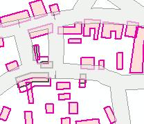
15 Simple case existing features Feature Class (Roads) Cartographic Representation (Clearer roads) Town Plan Map 15
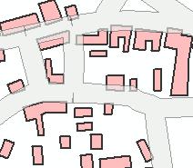
16 Multiple Representations Feature Class (Roads) Cartographic Representation (Clearer roads) Another Representation (Special roads) Town Plan map Leisure map 16
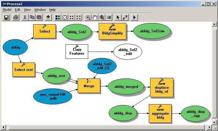
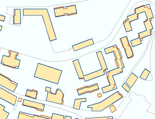
17 Enterprise (DLM) Case Cartographic Database Feature Class (Roads) Cartographic Representation (Better roads) Another Representation (Special roads) Extract via Geoprocessing: Copy Select Subset Generalize Town Plan map Leisure map DLM Feature Class (Detailed Roads) Landscape Database 17
18 Landscape Models, Cartographic Models, and Products Data Product Model Generalization Landscape Model Cartographic Generalization Cartographic Model Visual Product Course Routing Derive Features DLM Coarse Derive Features Derive Reps DCM_Small Rep250S Rep200A 1:250K Sheet 1:200K Atlas Derive Features DLM Medium Derive Features Derive Reps DCM_Mid Rep100T Rep50T 1:100K Topo 1:50K Topo Fine Routing Change in Real World DLM Fine (Master) Derive Features Derive Reps DCM_Basic Rep10S Rep10P 1:10K Sheet 1:10K PDF 18
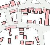
19 Geoprocessing and Generalization 19
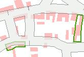
20 Geoprocessing ArcToolbox Core tools Python Scripts and AMLs Models (including other tools) Any executable 20


21 Generalization Generalization is about abstraction exaggerate the important subdue or remove irrelevant detail move reality to make space Needs pattern recognition Humans find hard, while computers find harder! 1:10,000 1:50,000 1:250,000 Crown Copyright, Courtesy OSGB 21


22 Generalization Algorithms Simplify buildings Aggregate buildings avoiding streets Displace buildings from roads Collapse double-line roads to centerlines Aggregate polygons Displace linear features 22
23 Generalization Process Models Data Ordnance Survey GB Crown Copyright 23
24 New Generalization Tools Four New tools to Generalize Database Features Simplify Polygon - Simplifies a polygon by removing small fluctuations or extraneous bends from its boundary and preserves its essential shape Simplify Building - Simplifies the boundary or footprint of a building polygon while maintaining its essential shape and size Aggregate Polygon - Combines disjoint and adjacent polygons into new area features based on a distance Collapse Dual Lines to Centerlines - Derives centerlines (single lines) from dual-line features 24

25 Simplify Polygons 25

26 Simplify Buildings 26

27 Aggregate Polygons Non-orthogonal Orthogonal 27

28 Collapse Dual-Lines To Centerline 28
29 Generalization is Hard Can t t do it a feature at a time Involves relationships with neighbours Can t t do it a layer at a time Relationships are with features of many classes Can t t do uniformly Even features of one class have different surroundings Can t t do it across whole map at once Must localize or partition Can t t do it just on geometry Needs understanding of topology and of attributes 29
30 Possible Generalization Flow Data Structure Enrichment Partitioning Meso area Classification Pattern & Group Detection If worse, undo Context Analysis Dispatch to Appropriate Algorithm Reclassify, Aggregate Exaggerate, Simplify, Displace, Typify, Check Loop until Done 30
31 Update Change at largest scale then propagate incremental differences See [Briat, Monnot, Kressmann 2005] ICA paper: Incremental Update of Cartographic Data in a Versioned Environment 31
32 Summary Advanced cartographic representation mechanisms and cartographic editing tools will soon become available in a commodity GIS. Together with production automation and graphics capabilities they will dramatically change the scope of automated cartography, facilitating the generation of multiple products from a central database. The human freedom enabled by the override system, combined with the symbolization rule pipeline, will permit high-quality attractive cartography within a database-centered environment. The representation and override mechanisms, together with the geoprocessing framework also form the foundation for generalization processes and incremental update propagation 32
33 Questions and Comments? 33
GIS-Based Generalization and Multiple Representation of Spatial Data
 GIS-Based Generalization and Multiple of Spatial Data Paul Hardy, Dan Lee ESRI Inc, 380 New York St., Redlands, CA 92373, USA phardy@esri.com,dlee@esri.com Abstract. It is a strategic goal of many national
AUTOMATING GENERALIZATION TOOLS AND MODELS
 AUTOMATING GENERALIZATION TOOLS AND MODELS Dan Lee and Paul Hardy ESRI, Inc. 380 New York St., Redlands CA 92373, USA Telephone: (909) 793-2853; Fax: (909) 793-5953 E-mail: dlee@esri.com; phardy@esri.com
ESRI Quality Solution
 ESRI Quality Solution Paul Hardy Business Development Consultant (NMCAs) ESRI Europe phardy@esri.com ESRI Quality Solution Geodatabase Integrity Schema constraints (Attribute Domains etc) Rich data types
Neue Landeskarte der Schweiz
 Neue Landeskarte der Schweiz Erfahrungen bei der Realisierung eines GIS-basierten Kartografischen Produktionssystems bei der swisstopo Cory Eicher, Barbara Schneider, Markus Bedel & Dieter Neuffer ESRI
GENERALIZATION IN THE NEW GENERATION OF GIS. Dan Lee ESRI, Inc. 380 New York Street Redlands, CA USA Fax:
 GENERALIZATION IN THE NEW GENERATION OF GIS Dan Lee ESRI, Inc. 380 New York Street Redlands, CA 92373 USA dlee@esri.com Fax: 909-793-5953 Abstract In the research and development of automated map generalization,
ArcGIS Tools for Professional Cartography
 ArcGIS Tools for Professional Cartography By Makram Murad-al-shaikh M.S. Cartography Senior instructor ESRI Educational Services ICC - A Coruña - Spain, 9-16 July, 2005 Overview Overview of the ArcGIS
Esri Production Mapping: Map Automation & Advanced Cartography MADHURA PHATERPEKAR JOE SHEFFIELD
 Esri Production Mapping: Map Automation & Advanced Cartography MADHURA PHATERPEKAR JOE SHEFFIELD Traditional Cartography What you really want Cartographic Workflow Output Cartographic Data Symbology Layout
An Information Model for Maps: Towards Cartographic Production from GIS Databases
 An Information Model for s: Towards Cartographic Production from GIS Databases Aileen Buckley, Ph.D. and Charlie Frye Senior Cartographic Researchers, ESRI Barbara Buttenfield, Ph.D. Professor, University
AdV Project: Map Production of the DTK50
 Geoinformation und Landentwicklung AdV Project: Map Production of the DTK50 Sabine Urbanke, LGL Baden-Württemberg Landesamt für Geoinformation und Landentwicklung Baden-Württemberg (LGL) (State Authority
Multi-scale Representation: Modelling and Updating
 Multi-scale Representation: Modelling and Updating Osman Nuri ÇOBANKAYA 1, Necla ULUĞTEKİN 2 1 General Command of Mapping, Ankara osmannuri.cobankaya@hgk.msb.gov.tr 2 İstanbul Technical University, İstanbul
Performing Advanced Cartography with Esri Production Mapping
 Esri International User Conference San Diego, California Technical Workshops July 25, 2012 Performing Advanced Cartography with Esri Production Mapping Tania Pal & Madhura Phaterpekar Agenda Outline generic
Lecture 2. A Review: Geographic Information Systems & ArcGIS Basics
 Lecture 2 A Review: Geographic Information Systems & ArcGIS Basics GIS Overview Types of Maps Symbolization & Classification Map Elements GIS Data Models Coordinate Systems and Projections Scale Geodatabases
MODELING ACTIVE DATABASE-DRIVEN CARTOGRAPHY WITHIN GIS DATABASES
 Page 1 of 7 MODELING ACTIVE DATABASE-DRIVEN CARTOGRAPHY WITHIN GIS DATABASES Abstract Charlie Frye and Cory L. Eicher ESRI, 380 New York Street, Redlands, CA 92373 GIS databases contain classes of features
Designing GIS Databases to Support Mapping and Map Production Charlie Frye, ESRI Redlands Aileen Buckley, ESRI Redlands
 Designing GIS Databases to Support Mapping and Map Production Charlie Frye, ESRI Redlands Aileen Buckley, ESRI Redlands 1 Designing GIS Databases to Support Mapping and Map Production Charlie Frye, ESRI
Esri Defense Mapping: Cartographic Production. Bo King
 Esri Defense Mapping: Cartographic Production Bo King Agenda Esri Defense Mapping: Cartographic Production Solution Overview Desktop Cartographic Production Workflow - Create Rapid Graphic Product On Demand
Aileen Buckley, Ph.D. and Charlie Frye
 An Information Model for Maps: Towards Production from GIS Databases Aileen Buckley, Ph.D. and Charlie Frye Researchers, ESRI GIS vs. cart GIS Outline of the presentation Introduction Differences between
Problems and Challenges
 2018 Esri Petroleum GIS Conference Problems and Challenges May 9 10, 2018 Houston, Texas George R. Brown Convention Center Disunity of drawing standards and format Large amount of work in Cartography,
Performing Map Cartography. using Esri Production Mapping
 AGENDA Performing Map Cartography Presentation Title using Esri Production Mapping Name of Speaker Company Name Kannan Jayaraman Agenda Introduction What s New in ArcGIS 10.1 ESRI Production Mapping Mapping
Geoprocessing Tools at ArcGIS 9.2 Desktop
 Geoprocessing Tools at ArcGIS 9.2 Desktop Analysis Tools Analysis Tools \ Extract Clip Analysis Tools \ Extract Select Analysis Tools \ Extract Split Analysis Tools \ Extract Table Select Analysis Tools
Outline. Chapter 1. A history of products. What is ArcGIS? What is GIS? Some GIS applications Introducing the ArcGIS products How does GIS work?
 Outline Chapter 1 Introducing ArcGIS What is GIS? Some GIS applications Introducing the ArcGIS products How does GIS work? Basic data formats The ArcCatalog interface 1-1 1-2 A history of products Arc/Info
IndiFrag v2.1: An Object-based Fragmentation Analysis Software Tool
 IndiFrag v2.1: An Object-based Fragmentation Analysis Software Tool Geo-Environmental Cartography and Remote Sensing Group http://cgat.webs.upv.es/software/ Universitat Politècnica de València Introduction
GIS CONCEPTS ARCGIS METHODS AND. 3 rd Edition, July David M. Theobald, Ph.D. Warner College of Natural Resources Colorado State University
 GIS CONCEPTS AND ARCGIS METHODS 3 rd Edition, July 2007 David M. Theobald, Ph.D. Warner College of Natural Resources Colorado State University Copyright Copyright 2007 by David M. Theobald. All rights
Geog 469 GIS Workshop. Data Analysis
 Geog 469 GIS Workshop Data Analysis Outline 1. What kinds of need-to-know questions can be addressed using GIS data analysis? 2. What is a typology of GIS operations? 3. What kinds of operations are useful
ArcGIS Pro: Essential Workflows STUDENT EDITION
 ArcGIS Pro: Essential Workflows STUDENT EDITION Copyright 2018 Esri All rights reserved. Course version 6.0. Version release date August 2018. Printed in the United States of America. The information contained
Linear Referencing in Boulder County, CO. Getting Started
 Linear Referencing in Boulder County, CO Getting Started 1 Authors Janie Pierre GIS Technician, Boulder County Road centerline and storm sewer geodatabases & maps John Mosher GIS Specialist, Boulder County
UNIT 4: USING ArcGIS. Instructor: Emmanuel K. Appiah-Adjei (PhD) Department of Geological Engineering KNUST, Kumasi
 Department of Geological Engineering KNUST, Kumasi") UNIT 4: USING ArcGIS Instructor: Emmanuel K. Appiah-Adjei (PhD) Department of Geological Engineering KNUST, Kumasi Getting to Know ArcGIS ArcGIS is an integrated collection of GIS software products ArcGIS
UNIT 4: USING ArcGIS Instructor: Emmanuel K. Appiah-Adjei (PhD) Department of Geological Engineering KNUST, Kumasi Getting to Know ArcGIS ArcGIS is an integrated collection of GIS software products ArcGIS
Geodatabase An Introduction
 2013 Esri International User Conference July 8 12, 2013 San Diego, California Technical Workshop Geodatabase An Introduction David Crawford and Jonathan Murphy Session Path The Geodatabase What is it?
Working with the Geodatabase
 Working with the Geodatabase Agenda What is the geodatabase? Benefits of the geodatabase Inside the geodatabase Geodatabase rules Demos Additional resources and training Q & A The Geodatabase is the foundation
Multiple Representations of Geospatial Data: A Cartographic Search for the Holy Grail
 Multiple Representations of Geospatial Data: A Cartographic Search for the Holy Grail Barbara P. Buttenfield University of Colorado, Boulder babs@colorado.edu Collaboration with Cindy Brewer, Penn State
The Danish enterprise approach to create and publish nautical products.covering the waters along the west coast of Greenland
 The Danish enterprise approach to create and publish nautical products.covering the waters along the west coast of Greenland Charlotte Bjerregaard Overview of data, charts and tasks Old production/new
Spatial Analysis with ArcGIS Pro STUDENT EDITION
 Spatial Analysis with ArcGIS Pro STUDENT EDITION Copyright 2018 Esri All rights reserved. Course version 2.0. Version release date November 2018. Printed in the United States of America. The information
ArcGIS for Desktop. ArcGIS for Desktop is the primary authoring tool for the ArcGIS platform.
 ArcGIS for Desktop ArcGIS for Desktop ArcGIS for Desktop is the primary authoring tool for the ArcGIS platform. Beyond showing your data as points on a map, ArcGIS for Desktop gives you the power to manage
GIS Data Production and Editing Pathway
 GIS Data Production and Editing Pathway Table of Contents ArcGIS Desktop II: Tools and Functionality 3 ArcGIS Desktop III: GIS Workflows and Analysis 6 Building Geodatabases 8 Creating and Maintaining
Automated generalisation in production at Kadaster
 Automated generalisation in production at Kadaster NL Vincent van Altena 1, Ron Nijhuis 1, Marc Post 1, Ben Bruns 1, Jantien Stoter 1,2 1 Kadaster, The Netherlands, email: firstname.secondname@kadaster.nl
Cartography: Modeling GIS data for Mapmaking. Aileen Buckley, Ph.D. Senior Cartographic Researcher, ESRI. Barbara Buttenfield, Ph.D.
 Slide 1 Cartography: Modeling GIS data for Mapmaking Aileen Buckley, Ph.D. Senior Cartographic Researcher, ESRI Barbara Buttenfield, Ph.D. Professor, University of Colorado-Boulder Thank you coming to
The Danish enterprise approach to create and publish nautical products.covering the waters along the west coast of Greenland
 The Danish enterprise approach to create and publish nautical products.covering the waters along the west coast of Greenland Charlotte Bjerregaard Overview of data, charts and tasks Old production/new
Road Ahead: Linear Referencing and UPDM
 Road Ahead: Linear Referencing and UPDM Esri European Petroleum GIS Conference November 7, 2014 Congress Centre, London Your Work Making a Difference ArcGIS Is Evolving Your GIS Is Becoming Part of an
Chapter 5. Presenting Data
 Chapter 5. Presenting Data Copyright McGraw-Hill Education. Permission required for reproduction or display. 5-1 Basic principles of map design 5-2 1 Map Design Process 5-3 The map objective The first
GIS Generalization Dr. Zakaria Yehia Ahmed GIS Consultant Ain Shams University Tel: Mobile:
 GIS Generalization Dr. Zakaria Yehia Ahmed GIS Consultant Ain Shams University Tel: 24534976 Mobile: 01223384254 zyehia2005@yahoo.com Abstract GIS Generalization makes data less-detailed and less-complex
A CARTOGRAPHIC DATA MODEL FOR BETTER GEOGRAPHICAL VISUALIZATION BASED ON KNOWLEDGE
 A CARTOGRAPHIC DATA MODEL FOR BETTER GEOGRAPHICAL VISUALIZATION BASED ON KNOWLEDGE Yang MEI a, *, Lin LI a a School Of Resource And Environmental Science, Wuhan University,129 Luoyu Road, Wuhan 430079,
ArcGIS Data Models: Multiscale Topographic Maps. Charlie Frye Aileen Buckley
 ArcGIS Data Models: Multiscale Topographic Maps Charlie Frye Aileen Buckley Other cartography sessions ArcGIS ArcMap: Introduction to ArcMap Wed 1:30 PM, 6F ArcGIS Cartography: Map Design and Page Layout
ArcGIS Enterprise: What s New. Philip Heede Shannon Kalisky Melanie Summers Sam Williamson
 ArcGIS Enterprise: What s New Philip Heede Shannon Kalisky Melanie Summers Sam Williamson ArcGIS Enterprise is the new name for ArcGIS for Server What is ArcGIS Enterprise ArcGIS Enterprise is powerful
ESRI* Object Models; Data Capture
 ESRI* Object Models; Data Capture * Environmental Systems Research Institute Feature Class (spatial table) Number Age_Ma 1_sigma Rx_Type Size_kg 123 124 125 142 1.5 B_schist 136 2.0 G_schist Object Class
Service Oriented Mapping: Maps, Apps, Tools and Subscriptions
 Service Oriented Mapping: Maps, Apps, Tools and Subscriptions Paul Hardy, David Watkins Esri, USA : [phardy,dwatkins]@esri.com ABSTRACT This paper reviews the service-oriented mapping capabilities of a
a system for input, storage, manipulation, and output of geographic information. GIS combines software with hardware,
 Introduction to GIS Dr. Pranjit Kr. Sarma Assistant Professor Department of Geography Mangaldi College Mobile: +91 94357 04398 What is a GIS a system for input, storage, manipulation, and output of geographic
ESRI Object Models and Data Capture 2/1/2018
 Number 123 124 125 ESRI* Object Models; Data Capture Feature Class (spatial table) Age_Ma 142 136 1_sigma 1.5 2.0 Rx_Type B_schist G_schist Object Class (nonspatial table) Size_kg 3.4 1.3 Y Control Point
Getting Started with Community Maps
 Esri International User Conference San Diego, California Technical Workshops July 24, 2012 Getting Started with Community Maps Shane Matthews and Tamara Yoder Topics for this Session ArcGIS is a complete
ESRI* Object Models; Data Capture
 ESRI* Object Models; Data Capture * Environmental Systems Research Institute Feature Class (spatial table) Number Age_Ma 1_sigma Rx_Type Size_kg 123 124 125 142 1.5 B_schist 136 2.0 G_schist Object Class
ESRI Object Models and Data Capture 9/18/ /18/2014 M. Helper GEO327G/386G, UT Austin 2. ESRI Arc/Info ArcView ArcGIS
 ESRI Object Models; Data Capture Conceptual Models Conceptual Models Characterized all features or phenomena as: Feature Class (spatial table) Number Age_Ma 1_sigma Rx_Type 123 142 1.5 B_schist 124 136
SCAUG Community Maps Building a Living Atlas of the World
 SCAUG Community Maps Building a Living Atlas of the World Mark Stewart Topics: SCAUG ArcGIS Online Overview Community Maps Overview Community Maps Workflow Update Process Utilizing Your Contribution Community
Administering your Enterprise Geodatabase using Python. Jill Penney
 Administering your Enterprise Geodatabase using Python Jill Penney Assumptions Basic knowledge of python Basic knowledge enterprise geodatabases and workflows You want code Please turn off or silence cell
Data Entry. Getting coordinates and attributes into our GIS
 Data Entry Getting coordinates and attributes into our GIS How we used to collect spatial data How we collect spatial data now DATA SOURCES, INPUT, AND OUTPUT Manually digitizing from image or map sources
Linear Referencing Systems (LRS) Support for Municipal Asset Management Systems
 Support for Municipal Asset Management Systems") Linear Referencing Systems (LRS) Support for Municipal Asset Management Systems Esri Canada Infrastructure Asset Management Leadership Forum November 1, 2017 Toronto, ON David Loukes, P. Eng., FEC Andy
Linear Referencing Systems (LRS) Support for Municipal Asset Management Systems Esri Canada Infrastructure Asset Management Leadership Forum November 1, 2017 Toronto, ON David Loukes, P. Eng., FEC Andy
Conflation Tools and Workflows: An Introduction. DAN LEE and SILVIA CASAS
 Conflation Tools and Workflows: An Introduction DAN LEE and SILVIA CASAS Agenda What is Conflation? Geoprocessing Conflation Tools Conflation Workflows Conceptual workflow Single task workflows Demo 1:
Georelational Vector Data Model
 Georelational Vector Data Model Contents Georelational Data Model Representation of Simple Features Topology Non-topological Vector Data Data Models for Composite Features Geo-relational Looking at a paper
Geodatabase Essentials Part One - Intro to the Geodatabase. Jonathan Murphy Colin Zwicker
 Geodatabase Essentials Part One - Intro to the Geodatabase Jonathan Murphy Colin Zwicker Session Path The Geodatabase - What is it? - Why use it? - What types are there? Inside the Geodatabase Advanced
FIRE DEPARMENT SANTA CLARA COUNTY
 DEFINITION FIRE DEPARMENT SANTA CLARA COUNTY GEOGRAPHIC INFORMATION SYSTEM (GIS) ANALYST Under the direction of the Information Technology Officer, the GIS Analyst provides geo-spatial strategic planning,
The File Geodatabase API. Craig Gillgrass Lance Shipman
 The File Geodatabase API Craig Gillgrass Lance Shipman Schedule Cell phones and pagers Please complete the session survey we take your feedback very seriously! Overview File Geodatabase API - Introduction
Esri UC2013. Technical Workshop.
 Esri International User Conference San Diego, California Technical Workshops July 9, 2013 CAD: Introduction to using CAD Data in ArcGIS Jeff Reinhart & Phil Sanchez Agenda Overview of ArcGIS CAD Support
Geospatial capabilities, spatial data and services provided by Military Geographic Service
 Geospatial capabilities, spatial data and services provided by Military Geographic Service LtC Mariyan Markov PhD CONTENTS 1. INTRODUCTION - Workflow - Data sources remote sensing, direct field observation.
AUTOMATING PROCEDURE FOR TORNADO WARNING LEAD TIMES
 AUTOMATING PROCEDURE FOR TORNADO WARNING LEAD TIMES Tim Loftus BI Analyst, Meteorologist July 11, 2017 AGENDA SKYGUARD Current Process Manual calculation Automating Lead Time Calculation Model Builder/Python
ArcGIS Enterprise: What s New. Philip Heede Shannon Kalisky Melanie Summers Shreyas Shinde
 ArcGIS Enterprise: What s New Philip Heede Shannon Kalisky Melanie Summers Shreyas Shinde ArcGIS Enterprise is the new name for ArcGIS for Server ArcGIS Enterprise Software Components ArcGIS Server Portal
AUTOMATIC DIGITIZATION OF CONVENTIONAL MAPS AND CARTOGRAPHIC PATTERN RECOGNITION
 Abstract: AUTOMATC DGTZATON OF CONVENTONAL MAPS AND CARTOGRAPHC PATTERN RECOGNTON Werner Lichtner nstitute of Cartography (fk) University of Hannover FRG Commission V One important task of the establishment
Department s. With Model Builder
 Automate Planning Department s GIS Processes With Model Builder Jorge Morteo, GISP GIS Analyst City of Las Vegas Department of Planning Presentation The purpose of this presentation is to show the use
An Introduction to the Community Maps Information Model
 Esri International User Conference July 23 27 San Diego Convention Center An Introduction to the Community Maps Information Model Seth Sarakaitis Agenda Overview of Community Maps Program Information Models
Esri Training by Microcenter Prepare to Innovate. Microcenter Course Catalog
 Esri Training by Microcenter Prepare to Innovate 2015 Instructor-Led Courses Microcenter Course Catalog ArcGIS Foundational Courses Designed to meet the learning needs of professionals whose GIS experience
THE QUALITY CONTROL OF VECTOR MAP DATA
 THE QUALITY CONTROL OF VECTOR MAP DATA Wu Fanghua Liu Pingzhi Jincheng Xi an Research Institute of Surveying and Mapping (P.R.China ShanXi Xi an Middle 1 Yanta Road 710054) (e-mail :wufh999@yahoo.com.cn)
Improving Map Generalisation of Buildings by Introduction of Urban Context Rules
 Improving Map Generalisation of Buildings by Introduction of Urban Context Rules S. Steiniger 1, P. Taillandier 2 1 University of Zurich, Department of Geography, Winterthurerstrasse 190, CH 8057 Zürich,
ArcGIS. for Server. Understanding our World
 ArcGIS for Server Understanding our World ArcGIS for Server Create, Distribute, and Manage GIS Services You can use ArcGIS for Server to create services from your mapping and geographic information system
Spatial Analysis with Web GIS. Rachel Weeden
 Spatial Analysis with Web GIS Rachel Weeden Agenda Subhead goes here Introducing ArcGIS Online Spatial Analysis Workflows Scenarios Other Options Resources ArcGIS is a Platform Making mapping and analytics
Enabling Success in Enterprise Asset Management: Case Study for Developing and Integrating GIS with CMMS for a Large WWTP
 Enabling Success in Enterprise Asset Management: Case Study for Developing and Integrating GIS with CMMS for a Large WWTP Allison Blake, P.E. 1*, Matthew Jalbert, P.E. 2, Julia J. Hunt, P.E. 2, Mazen Kawasmi,
The improvement of production of the GDR50LT in Lithuania
 The improvement of production of the in Lithuania Kęstutis PAPŠYS, Lina PAPŠIENĖ, Julius D. BUDREVIČIUS, Marius MARMA, Evaldas ROŽANSKAS, Mindaugas PAŽEMYS / GIS-Centras Jurgita ŠPŪRAITĖ / National Land
GIS Level 2. MIT GIS Services
 GIS Level 2 MIT GIS Services http://libraries.mit.edu/gis Email: gishelp@mit.edu TOOLS IN THIS WORKSHOP - Definition Queries - Create a new field in the attribute table - Field Calculator - Add XY Data
LRS Task Force June 13, REVISION HISTORY
 North Carolina Department of Transportation Geographic Information Systems (GIS) Unit LINEAR REFERENCING SYSTEM (LRS) PROJECT DEFINITION Version 1.0 REVISION HISTORY Date Document Manager Revision Purpose
AN ATTEMPT TO AUTOMATED GENERALIZATION OF BUILDINGS AND SETTLEMENT AREAS IN TOPOGRAPHIC MAPS
 AN ATTEMPT TO AUTOMATED GENERALIZATION OF BUILDINGS AND SETTLEMENT AREAS IN TOPOGRAPHIC MAPS M. Basaraner * and M. Selcuk Yildiz Technical University (YTU), Department of Geodetic and Photogrammetric Engineering,
DATA SOURCES AND INPUT IN GIS. By Prof. A. Balasubramanian Centre for Advanced Studies in Earth Science, University of Mysore, Mysore
 DATA SOURCES AND INPUT IN GIS By Prof. A. Balasubramanian Centre for Advanced Studies in Earth Science, University of Mysore, Mysore 1 1. GIS stands for 'Geographic Information System'. It is a computer-based
DP Project Development Pvt. Ltd.
 Dear Sir/Madam, Greetings!!! Thanks for contacting DP Project Development for your training requirement. DP Project Development is leading professional training provider in GIS technologies and GIS application
Spatial Data Analysis with ArcGIS Desktop: From Basic to Advance
 Spatial Data Analysis with ArcGIS Desktop: From Basic to Advance 1. Course overview Modern environmental, energy as well as resource modeling and planning require huge amount of geographically located
Using CAD data in ArcGIS
 Using CAD data in ArcGIS Phil Sanchez and Jeff Reinhart Esri UC 2014 Technical Workshop Agenda Overview of ArcGIS CAD Support Using CAD Datasets in ArcMap Georeferencing CAD data for ArcGIS Loading CAD
New Zealand Aeronautical Charting the ArcMap Challenge. Presenter: Beryl Pimblott Explorer Graphics Ltd
 New Zealand Aeronautical Charting the ArcMap Challenge Presenter: Beryl Pimblott Explorer Graphics Ltd Abstract This presentation will be on the production of a national series of Visual Navigation charts
Multiple Representations of Geospatial Data: A Cartographic Search for the Holy Grail?
 Multiple Representations of Geospatial Data: A Cartographic Search for the Holy Grail? Barbara P. Buttenfield University of Colorado Boulder Research Faculty Affiliate, USGS-CEGIS babs@colorado.edu 13
THE CONSERVATION LANDSCAPE CONTEXT TOOLBOX: A Custom ESRI ArcToolbox for the Stewardship of Conservation Lands in Rhode Island
 THE CONSERVATION LANDSCAPE CONTEXT TOOLBOX: A Custom ESRI ArcToolbox for the Stewardship of Conservation Lands in Rhode Island Ann Borowik M.E.S.M. Research Project University of Rhode Island May 2008
INTELLIGENT GENERALISATION OF URBAN ROAD NETWORKS. Alistair Edwardes and William Mackaness
 INTELLIGENT GENERALISATION OF URBAN ROAD NETWORKS Alistair Edwardes and William Mackaness Department of Geography, University of Edinburgh, Drummond Street, EDINBURGH EH8 9XP, Scotland, U.K. Tel. 0131
FUNDAMENTALS OF GEOINFORMATICS PART-II (CLASS: FYBSc SEM- II)
") FUNDAMENTALS OF GEOINFORMATICS PART-II (CLASS: FYBSc SEM- II) UNIT:-I: INTRODUCTION TO GIS 1.1.Definition, Potential of GIS, Concept of Space and Time 1.2.Components of GIS, Evolution/Origin and Objectives
FUNDAMENTALS OF GEOINFORMATICS PART-II (CLASS: FYBSc SEM- II) UNIT:-I: INTRODUCTION TO GIS 1.1.Definition, Potential of GIS, Concept of Space and Time 1.2.Components of GIS, Evolution/Origin and Objectives
PC ARC/INFO and Data Automation Kit GIS Tools for Your PC
 ESRI PC ARC/INFO and Data Automation Kit GIS Tools for Your PC PC ARC/INFO High-quality digitizing and data entry Powerful topology building Cartographic design and query Spatial database query and analysis
GIS PORTFOLIO MOHAMED MAGDY MOHAMED HUSSAIN GIS ENGINEER. UWF GIS ONLINE CERTIFICATE GIS Internship (GIS4944)
") 2012 GIS PORTFOLIO MOHAMED MAGDY MOHAMED HUSSAIN GIS ENGINEER UWF GIS ONLINE CERTIFICATE GIS Internship (GIS4944) Portfolio Table of Contents Subject... Page Personal statement/mission/philosophy... 1
2012 GIS PORTFOLIO MOHAMED MAGDY MOHAMED HUSSAIN GIS ENGINEER UWF GIS ONLINE CERTIFICATE GIS Internship (GIS4944) Portfolio Table of Contents Subject... Page Personal statement/mission/philosophy... 1
Map image from the Atlas of Oregon (2nd. Ed.), Copyright 2001 University of Oregon Press
, Copyright 2001 University of Oregon Press") Map Layout and Cartographic Design with ArcGIS Desktop Matthew Baker ESRI Educational Services Redlands, CA Education UC 2008 1 Seminar overview General map design principles Working with map elements
Map Layout and Cartographic Design with ArcGIS Desktop Matthew Baker ESRI Educational Services Redlands, CA Education UC 2008 1 Seminar overview General map design principles Working with map elements
Enabling ENVI. ArcGIS for Server
 Enabling ENVI throughh ArcGIS for Server 1 Imagery: A Unique and Valuable Source of Data Imagery is not just a base map, but a layer of rich information that can address problems faced by GIS users. >
Assisted cartographic generalization: Can we learn from classical maps?
 Assisted cartographic generalization: Can we learn from classical maps? Vaclav Talhofer *, Libuse Sokolova ** * University of Defence, Department of Military Geography and Meteorology, Brno, the Czech
Web-based Tools for Complex Spatial Data. Bill Daigle Montana Fish, Wildlife & Parks
 Web-based Tools for Complex Spatial Data Bill Daigle Montana Fish, Wildlife & Parks 1960s - Fisheries Bureau started centralizing data 1980s - Data computerized NW Power Act -> Montana Rivers Study-> Montana
A Prototype Method for Storing Symbols for Multiple Maps in a Single Geodatabase Using ArcGIS Cartographic Representations
 University of Redlands InSPIRe @ Redlands MS GIS Program Major Individual Projects Geographic Information Systems 5-2007 A Prototype Method for Storing Symbols for Multiple Maps in a Single Geodatabase
ArcGIS Pro Q&A Session. NWGIS Conference, October 11, 2017 With John Sharrard, Esri GIS Solutions Engineer
 ArcGIS Pro Q&A Session NWGIS Conference, October 11, 2017 With John Sharrard, Esri GIS Solutions Engineer jsharrard@esri.com ArcGIS Desktop The applications ArcGIS Pro ArcMap ArcCatalog ArcScene ArcGlobe
GENERAL COMMAND OF MAPPING TURKEY
 GENERAL COMMAND OF MAPPING (HARİTA GENEL KOMUTANLIĞI) TURKEY NATIONAL REPORT (2007-2011) 15 th General Assembly International Cartographic Conference Paris FRANCE, 03-08 July 2011 NATIONAL REPORT (2007-2011)
Esri Production Mapping: An Introduction
 Esri Production Mapping: An Introduction Amber Bethell & Joseph Sheffield Esri UC 2014 Technical Workshop Your organization s processes Collect Share Manage Produce Your organization s needs Standardization
Lecture 6 - Raster Data Model & GIS File Organization
 Lecture 6 - Raster Data Model & GIS File Organization I. Overview of Raster Data Model Raster data models define objects in a fixed manner see Figure 1. Each grid cell has fixed size (resolution). The
EMMA : ECDC Mapping and Multilayer Analysis A GIS enterprise solution to EU agency. Sharing experience and learning from the others
 EMMA : ECDC Mapping and Multilayer Analysis A GIS enterprise solution to EU agency. Sharing experience and learning from the others Lorenzo De Simone, GIS Expert/ EMMA Project Manager 2014 GIS Workshop,
 Boone County GIS has the right to inquire about and investigate the use of any requested products and deny access to anyone based on concerns relating to privacy, security, public health, public safety,
Spatial Intelligence. Angela Schwering
 Spatial Intelligence Angela Schwering What I do What I do intelligent representation and processing of spatial information From the Cognitive Perspective How do humans perceive spatial information? How
USING GIS IN WATER SUPPLY AND SEWER MODELLING AND MANAGEMENT
 USING GIS IN WATER SUPPLY AND SEWER MODELLING AND MANAGEMENT HENRIETTE TAMAŠAUSKAS*, L.C. LARSEN, O. MARK DHI Water and Environment, Agern Allé 5 2970 Hørsholm, Denmark *Corresponding author, e-mail: htt@dhigroup.com
software, just as word processors or databases are. GIS was originally developed and cartographic capabilities have been augmented by analysis tools.
 1. INTRODUCTION 1.1Background A GIS is a Geographic Information System, a software package for creating, viewing, and analyzing geographic information or spatial data. GIS is a class of software, just