Map image from the Atlas of Oregon (2nd. Ed.), Copyright 2001 University of Oregon Press
|
|
|
- Sabina Page
- 5 years ago
- Views:
Transcription
1 Map Layout and Cartographic Design with ArcGIS Desktop Matthew Baker ESRI Educational Services Redlands, CA Education UC
2 Seminar overview General map design principles Working with map elements Using ArcMap templates t Tips and tricks for improving maps Education UC


3 Affective and substantive design Think before you draw Map design is a time-consuming process Affective What is the look or feel of the map? Historical, modern, technical Substantive What is shown on the map and for what purpose? Text blocks, charts, tables, images Map image from the Atlas of Oregon (2nd. Ed.), Copyright 2001 University of Oregon Press Education UC
4 Layout design Balance Margins White space Bounding boxes Alignment Unbalanced layout Education UC
5 Layout design Balance Margins White space Bounding boxes Alignment Balanced layout Education UC


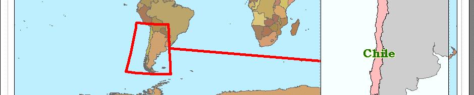
6 Layout design: Figure Ground Relationship Figure: object in front of the background Ground: Underlying plane behind elements Figure-Ground Relationship Separating figure from ground Enhanced using Drop shadow Draw order Contrast Map image from the Atlas of Oregon (2nd. Ed.) Copyright 2001 University of Oregon Press Education UC


7 Layout design Visual contrast Separates figure from ground Education UC


8 Layout design Visual contrast Education UC


9 Layout design Visual hierarchy More attention paid from top down Top: Important items Larger items Bottom Less important items Smaller items Map image courtesy of Indy Hurt University of Redlands, MS GIS Program Education UC
10 Seminar overview General map design principles Working with map elements Using ArcMap templates t Tips and tricks for improving maps Education UC


11 Data frames Manage multiple views of same data One or more per map page Most map elements are data frame properties North arrow Scale bar Grids and graticules Text as graphic element Education UC
12 Map elements Smart graphics Maintain dynamic link with Data View Select what's appropriate for the map objective Is north arrow necessary for population density? Is scale consistent across entire map? Do base map colors need to be included in legend? Education UC
13 Text elements Four categories Descriptive, Positional, Analytical, Metadata Text elements include: Title Author(s) Organization Data source Date of data and map Projection Disclosures Except for title, none should be prominent Limit tuseo of different e fonts Text elements have visual hierarchy Education UC


14 Add locational information Graticule, Reference and Measured grids Add from Data Frame Properties > Grid tab Axes Border Graticule Label text style Intervals Axis division ticks Education UC


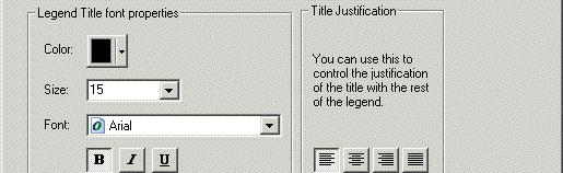

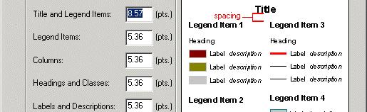

15 Tip: edit default legend properties Default settings Edited settings Education UC
16 Tip: edit scale bar properties Set increments that are easy to measure Left-of-zero divisions should be easy to use Default settings =? Enhanced settings = Education UC
17 Seminar overview General map design principles Working with map elements Using ArcMap templates t Tips and tricks for improving maps Education UC


18 What are templates? Re-usable documents that: Contain static elements Speed map creation Are stored as.mxt file Are useful for creating map series Standardize layouts Can be shared with other users Education UC


19 Template contents Graticule Neatline (border) Map Body Scalebar Legend Logo Projection North Arrow Title Source, Author Education UC


20 Create new maps Use existing template ArcMap supplies 28 in 4 categories Create new template e.g. different page sizes Modify existing Create new tab Add folder to directory Store your own library Within layout view, switch to another Education UC
21 Seminar overview General map design principles Working with map elements Using ArcMap templates t Tips and tricks for improving maps Education UC
22 Limit colors and shades 12 distinct colors 7 or 8 distinct shades Same color? Same color? Education UC
23 Know the map viewing distance Select text and symbol size based on viewer perspective ICA (International Cartographic Association) legibility standards: (Eye) 2 degree arc 2.9mm (.11 in) 5m (16.4 ft) Viewing Distance Size mm Viewing Distance Size in. 0.5 m 2 m 5m ft 5 ft 10 ft Education UC


24 Change data frame background color Colored background emphasizes visual hierarchy May take longer to print on larger page sizes Education UC


25 Use Grids and Guides Graphic element alignment tools Set ArcMap Options for units and snapping Aids visual balance, alignment Top Ruler Side Ruler Virtual Page Guides Education UC


26 Advanced Techniques Clip data frame to shape Clipped data frame Selected circle Education UC


27 Advanced Techniques Rotate data frame Data view Layout view with rotation (note north arrow) Education UC

28 Advanced Techniques Extent Rectangles Education UC


29 Advanced Techniques Masking effects Annotation without mask Annotation with mask Education UC
30 Advanced Techniques Text boxes Education UC
31 For more information ESRI Mapping Center Map examples, Ask A Cartographer, Blog, and more Virtual Campus Cartographic Design Using ArcGIS 9 Making Better Map Layouts with ArcGIS (7 module course) (free training seminar) Instructor Led Training Cartography with ArcGIS Managing Cartographic Data in the Geodatabase ESRI Press Designing Better Maps: A Guide for GIS Users Cynthia A. Brewer Cartographies of Disease: Maps, Mapping and Medicine Tom Koch Education UC
32 Questions? UC 2006 Tech Session 32
GEOREFERENCING, PROJECTIONS Part I. PRESENTING DATA Part II
 Week 7 GEOREFERENCING, PROJECTIONS Part I PRESENTING DATA Part II topics of the week Georeferencing Coordinate systems Map Projections ArcMap and Projections Geo-referencing Geo-referencing is the process
Performing Advanced Cartography with Esri Production Mapping
 Esri International User Conference San Diego, California Technical Workshops July 25, 2012 Performing Advanced Cartography with Esri Production Mapping Tania Pal & Madhura Phaterpekar Agenda Outline generic
ArcGIS Tools for Professional Cartography
 ArcGIS Tools for Professional Cartography By Makram Murad-al-shaikh M.S. Cartography Senior instructor ESRI Educational Services ICC - A Coruña - Spain, 9-16 July, 2005 Overview Overview of the ArcGIS
Performing Map Cartography. using Esri Production Mapping
 AGENDA Performing Map Cartography Presentation Title using Esri Production Mapping Name of Speaker Company Name Kannan Jayaraman Agenda Introduction What s New in ArcGIS 10.1 ESRI Production Mapping Mapping
Lecture 2. A Review: Geographic Information Systems & ArcGIS Basics
 Lecture 2 A Review: Geographic Information Systems & ArcGIS Basics GIS Overview Types of Maps Symbolization & Classification Map Elements GIS Data Models Coordinate Systems and Projections Scale Geodatabases
Esri Defense Mapping: Cartographic Production. Bo King
 Esri Defense Mapping: Cartographic Production Bo King Agenda Esri Defense Mapping: Cartographic Production Solution Overview Desktop Cartographic Production Workflow - Create Rapid Graphic Product On Demand
Esri UC2013. Technical Workshop.
 Esri International User Conference San Diego, California Technical Workshops July 9, 2013 CAD: Introduction to using CAD Data in ArcGIS Jeff Reinhart & Phil Sanchez Agenda Overview of ArcGIS CAD Support
Esri Production Mapping: Map Automation & Advanced Cartography MADHURA PHATERPEKAR JOE SHEFFIELD
 Esri Production Mapping: Map Automation & Advanced Cartography MADHURA PHATERPEKAR JOE SHEFFIELD Traditional Cartography What you really want Cartographic Workflow Output Cartographic Data Symbology Layout
Fundamentals of ArcGIS Desktop Pathway
 Fundamentals of ArcGIS Desktop Pathway Table of Contents ArcGIS Desktop I: Getting Started with GIS 3 ArcGIS Desktop II: Tools and Functionality 5 Understanding Geographic Data 8 Understanding Map Projections
Environmental Systems Research Institute
 Introduction to ArcGIS ESRI Environmental Systems Research Institute Redlands, California 2 ESRI GIS Development Arc/Info (coverage model) Versions 1-7 from 1980 1999 Arc Macro Language (AML) ArcView (shapefile
UNIT 4: USING ArcGIS. Instructor: Emmanuel K. Appiah-Adjei (PhD) Department of Geological Engineering KNUST, Kumasi
 Department of Geological Engineering KNUST, Kumasi") UNIT 4: USING ArcGIS Instructor: Emmanuel K. Appiah-Adjei (PhD) Department of Geological Engineering KNUST, Kumasi Getting to Know ArcGIS ArcGIS is an integrated collection of GIS software products ArcGIS
UNIT 4: USING ArcGIS Instructor: Emmanuel K. Appiah-Adjei (PhD) Department of Geological Engineering KNUST, Kumasi Getting to Know ArcGIS ArcGIS is an integrated collection of GIS software products ArcGIS
GTECH 380/722 Analytical and Computer Cartography Hunter College, CUNY Department of Geography
 GTECH 380/722 Analytical and Computer Cartography Hunter College, CUNY Department of Geography Fall 2014 Mondays 5:35PM to 9:15PM Instructor: Doug Williamson, PhD Email: Douglas.Williamson@hunter.cuny.edu
Basic principles of cartographic design. Makram Murad-al-shaikh M.S. Cartography Esri education delivery team
 Basic principles of cartographic design Makram Murad-al-shaikh M.S. Cartography Esri education delivery team Cartographic concepts Cartography defined The communication channel - Why maps fail Objectives
Lecture 2. Introduction to ESRI s ArcGIS Desktop and ArcMap
 Lecture 2 Introduction to ESRI s ArcGIS Desktop and ArcMap Outline ESRI What is ArcGIS? ArcGIS Desktop ArcMap Overview Views Layers Attribute Tables Help! Scale Tips and Tricks ESRI Environmental Systems
ARMY ITAM GIS: Automating Standard Army Training Map Production
 ARMY ITAM GIS: Automating Standard Army Training Map Production Douglas Willets ITAM Western Regional Support Center, Center for Environmental Management of Military Lands, Colorado State University, Fort
GIS CONCEPTS ARCGIS METHODS AND. 3 rd Edition, July David M. Theobald, Ph.D. Warner College of Natural Resources Colorado State University
 GIS CONCEPTS AND ARCGIS METHODS 3 rd Edition, July 2007 David M. Theobald, Ph.D. Warner College of Natural Resources Colorado State University Copyright Copyright 2007 by David M. Theobald. All rights
CHAPTER 9 DATA DISPLAY AND CARTOGRAPHY
 CHAPTER 9 DATA DISPLAY AND CARTOGRAPHY 9.1 Cartographic Representation 9.1.1 Spatial Features and Map Symbols 9.1.2 Use of Color 9.1.3 Data Classification 9.1.4 Generalization Box 9.1 Representations 9.2
Using CAD data in ArcGIS
 Using CAD data in ArcGIS Phil Sanchez and Jeff Reinhart Esri UC 2014 Technical Workshop Agenda Overview of ArcGIS CAD Support Using CAD Datasets in ArcMap Georeferencing CAD data for ArcGIS Loading CAD
ArcGIS Pro: Essential Workflows STUDENT EDITION
 ArcGIS Pro: Essential Workflows STUDENT EDITION Copyright 2018 Esri All rights reserved. Course version 6.0. Version release date August 2018. Printed in the United States of America. The information contained
A Review: Geographic Information Systems & ArcGIS Basics
 A Review: Geographic Information Systems & ArcGIS Basics Geographic Information Systems Geographic Information Science Why is GIS important and what drives it? Applications of GIS ESRI s ArcGIS: A Review
GTECH 380/722 Analytical and Computer Cartography Hunter College, CUNY Department of Geography
 GTECH 380/722 Analytical and Computer Cartography Hunter College, CUNY Department of Geography Fall 2011 Mondays 5:35PM to 9:15PM Instructor: Doug Williamson, PhD Email: Douglas.Williamson@hunter.cuny.edu
How to Make or Plot a Graph or Chart in Excel
 This is a complete video tutorial on How to Make or Plot a Graph or Chart in Excel. To make complex chart like Gantt Chart, you have know the basic principles of making a chart. Though I have used Excel
Problems and Challenges
 2018 Esri Petroleum GIS Conference Problems and Challenges May 9 10, 2018 Houston, Texas George R. Brown Convention Center Disunity of drawing standards and format Large amount of work in Cartography,
The Geodatabase Working with Spatial Analyst. Calculating Elevation and Slope Values for Forested Roads, Streams, and Stands.
 GIS LAB 7 The Geodatabase Working with Spatial Analyst. Calculating Elevation and Slope Values for Forested Roads, Streams, and Stands. This lab will ask you to work with the Spatial Analyst extension.
ARCGIS TRAINING AT KU GIS LABS: INTRODUCTION TO GIS: EXPLORING ARCCATALOG AND ARCGIS TOOLS
 PHASE 1_3 rd SESSION ARCGIS TRAINING AT KU GIS LABS: INTRODUCTION TO GIS: EXPLORING ARCCATALOG AND ARCGIS TOOLS 3 rd SESSION REPORT: 25 TH -27 TH JUNE 2014 SCHOOL OF ENVIRONMENTAL STUDIES COMPUTER LAB
INTRODUCTION TO ARCGIS Version 10.*
 Week 3 INTRODUCTION TO ARCGIS Version 10.* topics of the week Overview of ArcGIS Using ArcCatalog Overview of ArcGIS Desktop ArcGIS Overview Scalable desktop applications ArcView ArcEditor ArcInfo ArcGIS
DP Project Development Pvt. Ltd.
 Dear Sir/Madam, Greetings!!! Thanks for contacting DP Project Development for your training requirement. DP Project Development is leading professional training provider in GIS technologies and GIS application
GIS Boot Camp for Education June th, 2011 Day 1. Instructor: Sabah Jabbouri Phone: (253) x 4854 Office: TC 136
 x 4854 Office: TC 136") GIS Boot Camp for Education June 27-30 th, 2011 Day 1 Instructor: Sabah Jabbouri Phone: (253) 833-9111 x 4854 Office: TC 136 Email: sjabbouri@greenriver.edu http://www.instruction.greenriver.edu/gis/ Summer
GIS Boot Camp for Education June 27-30 th, 2011 Day 1 Instructor: Sabah Jabbouri Phone: (253) 833-9111 x 4854 Office: TC 136 Email: sjabbouri@greenriver.edu http://www.instruction.greenriver.edu/gis/ Summer
CAD: Introduction to using CAD Data in ArcGIS. Kyle Williams & Jeff Reinhart
 CAD: Introduction to using CAD Data in ArcGIS Kyle Williams & Jeff Reinhart What we will accomplish today Overview of ArcGIS CAD Support Georeferencing CAD data for ArcGIS How Mapping Specification for
MAKING MAPS Cartographic Design & Principles Winter 2018
 MAKING MAPS Cartographic Design & Principles Winter 2018 Cartography the art, science, and technology of making maps, together with their study as scientific documents and works of art - The International
CE 365K Exercise 1: GIS Basemap for Design Project Spring 2014 Hydraulic Engineering Design
 CE 365K Exercise 1: GIS Basemap for Design Project Spring 2014 Hydraulic Engineering Design The purpose of this exercise is for you to construct a basemap in ArcGIS for your design project. You may execute
ArcGIS for Desktop. ArcGIS for Desktop is the primary authoring tool for the ArcGIS platform.
 ArcGIS for Desktop ArcGIS for Desktop ArcGIS for Desktop is the primary authoring tool for the ArcGIS platform. Beyond showing your data as points on a map, ArcGIS for Desktop gives you the power to manage
ArcGIS 9 ArcGIS StreetMap Tutorial
 ArcGIS 9 ArcGIS StreetMap Tutorial Copyright 2001 2008 ESRI All Rights Reserved. Printed in the United States of America. The information contained in this document is the exclusive property of ESRI. This
Week 8 Cookbook: Review and Reflection
 : Review and Reflection Week 8 Overview 8.1) Review and Reflection 8.2) Making Intelligent Maps: The map sheet as a blank canvas 8.3) Making Intelligent Maps: Base layers and analysis layers 8.4) ArcGIS
Introduction to Coastal GIS
 Introduction to Coastal GIS Event was held on Tues, 1/8/13 - Thurs, 1/10/13 Time: 9:00 am to 5:00 pm Location: Roger Williams University, Bristol, RI Audience: The intended audiences for this course are
An Information Model for Maps: Towards Cartographic Production from GIS Databases
 An Information Model for s: Towards Cartographic Production from GIS Databases Aileen Buckley, Ph.D. and Charlie Frye Senior Cartographic Researchers, ESRI Barbara Buttenfield, Ph.D. Professor, University
GIS CONCEPTS ARCGIS METHODS AND. 2 nd Edition, July David M. Theobald, Ph.D. Natural Resource Ecology Laboratory Colorado State University
 GIS CONCEPTS AND ARCGIS METHODS 2 nd Edition, July 2005 David M. Theobald, Ph.D. Natural Resource Ecology Laboratory Colorado State University Copyright Copyright 2005 by David M. Theobald. All rights
Geodatabase Management Pathway
 Geodatabase Management Pathway Table of Contents ArcGIS Desktop II: Tools and Functionality 3 ArcGIS Desktop III: GIS Workflows and Analysis 6 Building Geodatabases 8 Data Management in the Multiuser Geodatabase
New Zealand Aeronautical Charting the ArcMap Challenge. Presenter: Beryl Pimblott Explorer Graphics Ltd
 New Zealand Aeronautical Charting the ArcMap Challenge Presenter: Beryl Pimblott Explorer Graphics Ltd Abstract This presentation will be on the production of a national series of Visual Navigation charts
NR402 GIS Applications in Natural Resources
 NR402 GIS Applications in Natural Resources Lesson 1 Introduction to GIS Eva Strand, University of Idaho Map of the Pacific Northwest from http://www.or.blm.gov/gis/ Welcome to NR402 GIS Applications in
Task 1: Open ArcMap and activate the Spatial Analyst extension.
 Exercise 10 Spatial Analyst The following steps describe the general process that you will follow to complete the exercise. Specific steps will be provided later in the step-by-step instructions component
Linear Referencing in Boulder County, CO. Getting Started
 Linear Referencing in Boulder County, CO Getting Started 1 Authors Janie Pierre GIS Technician, Boulder County Road centerline and storm sewer geodatabases & maps John Mosher GIS Specialist, Boulder County
SCHOOL OF ENGINEERING AND TECHNOLOGY COMPUTER LAB
 PHASE 1_6 TH SESSION ARCGIS TRAINING AT KU GIS LABS: INTRODUCTION TO GIS: EXPLORING ARCCATALOG AND ARCGIS TOOLS 6 TH SESSION REPORT: 3 RD -5 TH SEPTEMBER 2014 SCHOOL OF ENGINEERING AND TECHNOLOGY COMPUTER
Cartography with Esri Production Mapping
 Cartography with Esri Production Mapping All rights reserved. Course version 1.3. Version release date September 2015. Printed in the United States of America. The information contained in this document
MODELING ACTIVE DATABASE-DRIVEN CARTOGRAPHY WITHIN GIS DATABASES
 Page 1 of 7 MODELING ACTIVE DATABASE-DRIVEN CARTOGRAPHY WITHIN GIS DATABASES Abstract Charlie Frye and Cory L. Eicher ESRI, 380 New York Street, Redlands, CA 92373 GIS databases contain classes of features
Lecture 3 GIS outputs. Dr. Zhang Spring, 2017
 Lecture 3 GIS outputs Dr. Zhang Spring, 2017 Model of the course Using and making maps Navigating GIS maps Map design Working with spatial data Geoprocessing Spatial data infrastructure Digitizing File
These modules are covered with a brief information and practical in ArcGIS Software and open source software also like QGIS, ILWIS.
 Online GIS Training and training modules covered are: 1. ArcGIS, Analysis, Fundamentals and Implementation 2. ArcGIS Web Data Sharing 3. ArcGIS for Desktop 4. ArcGIS for Server These modules are covered
Introduction to ArcMap
 Introduction to ArcMap ArcMap ArcMap is a Map-centric GUI tool used to perform map-based tasks Mapping Create maps by working geographically and interactively Display and present Export or print Publish
Troubleshooting Replication and Geodata Services. Liz Parrish & Ben Lin
 Troubleshooting Replication and Geodata Services Liz Parrish & Ben Lin AGENDA: Troubleshooting Replication and Geodata Services Overview Demo Troubleshooting Q & A Overview of Replication Liz Parrish What
Migrating Defense Workflows from ArcMap to ArcGIS Pro. Renee Bernstein and Jared Sellers
 Migrating Defense Workflows from ArcMap to ArcGIS Pro Renee Bernstein and Jared Sellers ArcGIS Desktop Desktop Web Device ArcMap ArcCatalog ArcScene ArcGlobe ArcGIS Pro portal Server Online Content and
GIS Workshop UCLS_Fall Forum 2014 Sowmya Selvarajan, PhD TABLE OF CONTENTS
 TABLE OF CONTENTS TITLE PAGE NO. 1. ArcGIS Basics I 2 a. Open and Save a Map Document 2 b. Work with Map Layers 2 c. Navigate in a Map Document 4 d. Measure Distances 4 2. ArcGIS Basics II 5 a. Work with
ArcGIS Pro Q&A Session. NWGIS Conference, October 11, 2017 With John Sharrard, Esri GIS Solutions Engineer
 ArcGIS Pro Q&A Session NWGIS Conference, October 11, 2017 With John Sharrard, Esri GIS Solutions Engineer jsharrard@esri.com ArcGIS Desktop The applications ArcGIS Pro ArcMap ArcCatalog ArcScene ArcGlobe
Create Satellite Image, Draw Maps
 Create Satellite Image, Draw Maps 1. The goal Using Google Earth, we want to create and import a background file into our Adviser program. From there, we will be creating paddock boundaries. The accuracy
GTECH 380/722 Analytical and Computer Cartography Hunter College, CUNY Department of Geography
 GTECH 380/722 Analytical and Computer Cartography Hunter College, CUNY Department of Geography Spring 2010 Wednesdays 5:35PM to 9:15PM Instructor: Doug Williamson, PhD Email: Douglas.Williamson@hunter.cuny.edu
Introduction to ArcGIS 10.2
 Introduction to ArcGIS 10.2 Francisco Olivera, Ph.D., P.E. Srikanth Koka Lauren Walker Aishwarya Vijaykumar Keri Clary Department of Civil Engineering April 21, 2014 Contents Brief Overview of ArcGIS 10.2...
Geodatabases and ArcCatalog
 Geodatabases and ArcCatalog Prepared by Francisco Olivera, Ph.D. and Srikanth Koka Department of Civil Engineering Texas A&M University February 2004 Contents Brief Overview of Geodatabases Goals of the
Esri Production Mapping: An Introduction
 Esri Production Mapping: An Introduction Amber Bethell & Joseph Sheffield Esri UC 2014 Technical Workshop Your organization s processes Collect Share Manage Produce Your organization s needs Standardization
Map Application Progression
 Map Application Progression Application Migration with Latest ArcGIS by Dean Chiang California Department of Fish and Wildlife What we do at CDFW Hunting and fishing licensing and regulation Conservation
GED 554 IT & GIS. Lecture 6 Exercise 5. May 10, 2013
 GED 554 IT & GIS Lecture 6 Exercise 5 May 10, 2013 Free GIS data sources ******************* Mapping numerical data & Symbolization ******************* Exercise: Making maps for presentation GIS DATA SOFTWARE
Geodatabase An Overview
 Federal GIS Conference February 9 10, 2015 Washington, DC Geodatabase An Overview Ralph Denkenberger - esri Session Path The Geodatabase - What is it? - Why use it? - What types are there? Inside the Geodatabase
Agenda. Introduction Exercise 1 Map Types. Part 1 ArcGIS Information and Organization Part 2 Purpose, Audience & Constraints.
 Agenda Introduction Exercise 1 Map Types Part 1 ArcGIS Information and Organization Part 2 Purpose, Audience & Constraints Exercise 2 Map Critique Break Part 3 Basic Cartographic Design Principles Part
That s Why We Did That! A MicroStation to ArcGIS Conversion Story
 GIS- April 2016 That s Why We Did That! A MicroStation to ArcGIS Conversion Story Michael Herrmann (mherrmann1@ncdot.gov) NC : County Road and Bridge Maps 3 Lenoir County Bridge Map Back In the Old Days.
Grid to LandGrid Volumetrics Workflow
 Grid to LandGrid Volumetrics Workflow Petra User Group Session Series Armin Schafer Technical Advisor Petra/Kingdom/GeoSyn/LogArc Encana Amphitheatre Nov 22, 2011 noon 1 pm PURPOSE: to demonstrate the
Incorporating ArcGIS Pro in your Curriculum
 AAG, Boston 2017 April 5, 2017 Incorporating ArcGIS Pro in your Curriculum Geri Miller Agenda Concerns Acknowledged Learning curve ArcGIS Pro does not have all the tools (perception) Licensing and offline
Snowden Cartography 1 GEOG 315:001 Cartography Thursdays 4:00 6:30PM F375 Fall 2010 Dr. Snowden Course Description
 Snowden Cartography 1 www.drksnowden.com GEOG 315:001 Cartography Thursdays 4:00 6:30PM F375 Fall 2010 Dr. Snowden Course Description Principles and theory of basic map design, layout, and communication.
An Alternate Career Choice for the Geography Major: Map, GIS, or Geographic Information Librarianship
 An Alternate Career Choice for the Geography Major: Map, GIS, or Geographic Information Librarianship Katherine H. Weimer Texas A&M University Libraries SWAAG 2007 - Bryan, Texas Overview of today s talk
What s New in ArcGIS 10.1 for Desktop. Karen Li Date: October 31, 2012
 What s New in ArcGIS 10.1 for Desktop Karen Li kli@esri.ca Date: October 31, 2012 Agenda This session is designed to help you understand: 1) What s new in mapping 2) What s new in geoprocessing 3) What
DRAFT SYLLABUS. Please use Blackboard to send messages.
 SYLLABUS Course Title: Geographic Information Systems and Spatial Analysis for Public Policy Academic Department/Course Number: PUBP 754 Semester/Year: Fall 2017 Building/Room: FH 307 Days/Time: W 4:30
ArcGIS ArcMap: Making Professional Quality Thematic Maps Charlie Frye, ESRI Redlands Aileen Buckley, ESRI Redlands
 ArcGIS ArcMap: Making Professional Quality Thematic Maps Charlie Frye, ESRI Redlands Aileen Buckley, ESRI Redlands 1 ArcGIS ArcMap: Making Professional Quality Thematic Maps Charlie Frye, ESRI Redlands
Portal for ArcGIS: An Introduction. Catherine Hynes and Derek Law
 Portal for ArcGIS: An Introduction Catherine Hynes and Derek Law Agenda Web GIS pattern Product overview Installation and deployment Configuration options Security options and groups Portal for ArcGIS
Please note: This presentation was used as speaker s notes for the 2008 Petroleum User Group Conference on Feb. 27, 2008 in Houston, TX.
 Please note: This presentation was used as speaker s notes for the 2008 Petroleum User Group Conference on Feb. 27, 2008 in Houston, TX. This material is not intended as course material nor reference material,
Spatial Data Analysis in Archaeology Anthropology 589b. Kriging Artifact Density Surfaces in ArcGIS
 Spatial Data Analysis in Archaeology Anthropology 589b Fraser D. Neiman University of Virginia 2.19.07 Spring 2007 Kriging Artifact Density Surfaces in ArcGIS 1. The ingredients. -A data file -- in.dbf
Designing GIS Databases to Support Mapping and Map Production Charlie Frye, ESRI Redlands Aileen Buckley, ESRI Redlands
 Designing GIS Databases to Support Mapping and Map Production Charlie Frye, ESRI Redlands Aileen Buckley, ESRI Redlands 1 Designing GIS Databases to Support Mapping and Map Production Charlie Frye, ESRI
Introduction to ArcGIS Server - Creating and Using GIS Services. Mark Ho Instructor Washington, DC
 Introduction to ArcGIS Server - Creating and Using GIS Services Mark Ho Instructor Washington, DC Technical Workshop Road Map Product overview Building server applications GIS services Developer Help resources
GIS Software. Evolution of GIS Software
 GIS Software The geoprocessing engines of GIS Major functions Collect, store, mange, query, analyze and present Key terms Program collections of instructions to manipulate data Package integrated collection
Tips and Tricks for Using ArcGIS for Fire Pre-Incident Planning Version II By: Chris Rogers Firefighter Kirkland Fire Department Kirkland Washington
 Tips and Tricks for Using ArcGIS for Fire Pre-Incident Planning Version II By: Chris Rogers Firefighter Kirkland Fire Department Kirkland Washington Abstract: The Kirkland Fire Department has been using
Chapter 5. Presenting Data
 Chapter 5. Presenting Data Copyright McGraw-Hill Education. Permission required for reproduction or display. 5-1 Basic principles of map design 5-2 1 Map Design Process 5-3 The map objective The first
GEG 5810 Geographic Information Systems I
 Eastern Illinois University NEW COURSE PROPOSAL CGS Agenda Item: 08-01 Proposal Effective Date: Fall 2008 GEG 5810 Geographic Information Systems I Please check one: X New course Revised course PART I:
Local Government Basemaps using ArcGIS
 Local Government Basemaps using ArcGIS Steve Grisé Scott Oppmann Tuesday, July 14, 10:15-11:30am SDCC 30B Topics Basemaps for Local Government Essential Application-Driven New Ideas Design Strategies Discussion
Introduction to Coastal GIS
 Held on Tues, 1/8/13 through Thurs, 1/10/13 Location: Roger Williams University, Bristol, RI Audience: The intended audiences for this course are federal and state personnel, municipal staff and officials,
GIS IN ECOLOGY: ANALYZING RASTER DATA
 GIS IN ECOLOGY: ANALYZING RASTER DATA Contents Introduction... 2 Raster Tools and Functionality... 2 Data Sources... 3 Tasks... 4 Getting Started... 4 Creating Raster Data... 5 Statistics... 8 Surface
(THIS IS AN OPTIONAL BUT WORTHWHILE EXERCISE)
") PART 2: Analysis in ArcGIS (THIS IS AN OPTIONAL BUT WORTHWHILE EXERCISE) Step 1: Start ArcCatalog and open a geodatabase If you have a shortcut icon for ArcCatalog on your desktop, double-click it to start
PART 2: Analysis in ArcGIS (THIS IS AN OPTIONAL BUT WORTHWHILE EXERCISE) Step 1: Start ArcCatalog and open a geodatabase If you have a shortcut icon for ArcCatalog on your desktop, double-click it to start
Working with Land Records in ArcGIS. Amadea Azerki CA Cadastral Mapping Association October 15-16, 2009
 Working with Land Records in ArcGIS Amadea Azerki CA Cadastral Mapping Association October 15-16, 2009 Agenda An Overview of Land Records Resource Center Template Resources Editing Toolbar Configuration
Trail Flow: Analysis of Drainage Patterns Affecting a Mountain Bike Trail
 Andy Belcher BAE 590 Professor Huffman 12.9.11 Location Trail Flow: Analysis of Drainage Patterns Affecting a Mountain Bike Trail The location of the project area rests in the Cary area of Wake County,
Available online at Analele Stiintifice ale Universitatii Al. I. Cuza din Iasi Seria Geologie 58 (1) (2012) 53 58
 (2012) 53 58") Available online at http://geology.uaic.ro/auig/ Analele Stiintifice ale Universitatii Al. I. Cuza din Iasi Seria Geologie 58 (1) (2012) 53 58 AUI GEOLOGIE GIS database for mineral resources: case study
Available online at http://geology.uaic.ro/auig/ Analele Stiintifice ale Universitatii Al. I. Cuza din Iasi Seria Geologie 58 (1) (2012) 53 58 AUI GEOLOGIE GIS database for mineral resources: case study
M E R C E R W I N WA L K T H R O U G H
 H E A L T H W E A L T H C A R E E R WA L K T H R O U G H C L I E N T S O L U T I O N S T E A M T A B L E O F C O N T E N T 1. Login to the Tool 2 2. Published reports... 7 3. Select Results Criteria...
Among various open-source GIS programs, QGIS can be the best suitable option which can be used across partners for reasons outlined below.
 Comparison of Geographic Information Systems (GIS) software As of January 2018, WHO has reached an agreement with ESRI (an international supplier of GIS software) for an unlimited use of ArcGIS Desktop
Process Simplification Office of the Vice President for Management and Budget. University Mapping Implementation Team (UMapIT) Final Report
 Final Report") Process Simplification Office of the Vice President for Management and Budget University Mapping Implementation Team (UMapIT) Final Report Table of Contents Introduction...3 Definitions...3 UMI Recommendations...3
Process Simplification Office of the Vice President for Management and Budget University Mapping Implementation Team (UMapIT) Final Report Table of Contents Introduction...3 Definitions...3 UMI Recommendations...3
Session 2: Exploring GIS
 EMB/RTC-GIS/Event 2/Session 2/1 Session 2: Exploring GIS Map Production - Exploring various GIS functions Objectives: 1. To create a map layer Air Pollution Index (API) and its attribute table 2. To symbolize
Working with ArcGIS: Classification
 Working with ArcGIS: Classification 2 Abbreviations D-click R-click TOC Double Click Right Click Table of Content Introduction The benefit from the use of geographic information system (GIS) software is
Using the Stock Hydrology Tools in ArcGIS
 Using the Stock Hydrology Tools in ArcGIS This lab exercise contains a homework assignment, detailed at the bottom, which is due Wednesday, October 6th. Several hydrology tools are part of the basic ArcGIS
Spatial Data Analysis with ArcGIS Desktop: From Basic to Advance
 Spatial Data Analysis with ArcGIS Desktop: From Basic to Advance 1. Course overview Modern environmental, energy as well as resource modeling and planning require huge amount of geographically located
EnvSci 360 Computer and Analytical Cartography
 EnvSci 360 Computer and Analytical Cartography Lecture 7 Mapping Images, Surfaces, and 3-D Data Brief Overview of Imagery What is Imagery? A spatial data model that defines space as an array of equally
BASIC TECHNOLOGY Pre K starts and shuts down computer, monitor, and printer E E D D P P P P P P P P P P
 BASIC TECHNOLOGY Pre K 1 2 3 4 5 6 7 8 9 10 11 12 starts and shuts down computer, monitor, and printer P P P P P P practices responsible use and care of technology devices P P P P P P opens and quits an
Space Objects. Section. When you finish this section, you should understand the following:
 GOLDMC02_132283433X 8/24/06 2:21 PM Page 97 Section 2 Space Objects When you finish this section, you should understand the following: How to create a 2D Space Object and label it with a Space Tag. How
Outline. Chapter 1. A history of products. What is ArcGIS? What is GIS? Some GIS applications Introducing the ArcGIS products How does GIS work?
 Outline Chapter 1 Introducing ArcGIS What is GIS? Some GIS applications Introducing the ArcGIS products How does GIS work? Basic data formats The ArcCatalog interface 1-1 1-2 A history of products Arc/Info
Acknowledgments xiii Preface xv. GIS Tutorial 1 Introducing GIS and health applications 1. What is GIS? 2
 Acknowledgments xiii Preface xv GIS Tutorial 1 Introducing GIS and health applications 1 What is GIS? 2 Spatial data 2 Digital map infrastructure 4 Unique capabilities of GIS 5 Installing ArcView and the
ARCGIS PRO COURSE, BEGINNER LEVEL ONLINE TRAINING GIS. Course. Training. .com
 ARC PRO COURSE, BEGINNER LEVEL ONLINE TRAINING Course.com TYC TRAINING OVERVIEW This course will provide a basic introduction in Arc PRO, the new Arc Desktop release. The training material will be focused
Spatial Representation
 Spatial Representation Visual Culture LCC6311 Tony F. Lockhart 12/9/2009 Page 2 of 5 Table of Contents Introduction... 3 Grid Layout... 3 Public School Funding Visualization... 3 Inspiration... 4 Works
Theory, Concepts and Terminology
 GIS Workshop: Theory, Concepts and Terminology 1 Theory, Concepts and Terminology Suggestion: Have Maptitude with a map open on computer so that we can refer to it for specific menu and interface items.