Evaluating Generalizations of Hydrography in Differing Terrains for The National Map of the United States
|
|
|
- Arabella Arnold
- 6 years ago
- Views:
Transcription
1 Evaluating Generalizations of Hydrography in Differing Terrains for The National Map of the United States Cynthia Brewer, Pennsylvania State University Barbara Buttenfield, University of Colorado Boulder E. Lynn Usery, CEGIS, U.S. Geological Survey Research Assistants: Chelsea Hanchett and Paulo Raposo, Penn State Mamata Akella, PSU ESRI Chris Anderson-Tarver and Jochen Wendel, CU-Boulder TNM data prep: NHD programming: Much advice: Tom Hale, USGS Larry Stanislawski, USGS Charlie Frye, ESRI
2 Scope Multiscale topographic mapping Generalization of National Hydrography Dataset (1:24,000 High Resolution NHD) Multiscale topographic map design For USGS web delivery portal The National Map (TNM) Scale range 1:20,000 1:200,000 (1:5K 1:2M planned) Why focus on hydrography? Highly sensitive to scale and landscape differences Commonly displayed on most base maps
3 Objectives Work toward full automation Minimize anticipated times for manual editing Use COTS software or USGS available code Maximize efficiency Make no more generalized data versions than necessary Level of detail (LoD) data Preserve important hydrographic/cartographic differences Terrain differences flat, hilly, mountainous Next: climate impacts humid, dry

4 Landscape Types Subbasin Sample Humid Flat: Upper Suwannee, FL-GA Hilly: Pomme de Terre, MO Mountainous: South Branch Potomac, W V Dry Flat: Lower Beaver, UT Hilly: Lower Prairie Dog Town Fork Red, TX Mountainous: Piceance-Yellow, CO Urban St. Louis, MO; Atlanta, GA Four in Iowa: North and South Raccoon, Middle Des Moines, and Lake Red Rock
5 Contextual Evaluating the solutions Map series across range of scales Critique by domain experts (hydrologists, cartographers) Validation Compare against 100K Medium Resolution NHD Metric Summary statistics on retained geometry Channel length, network local density Catchment areas, upstream drainage
6 Building an LoD 3 case studies A. Isolate a single, continuous centerline Intersect NHD Flowlines with NHD Areas Dissolve on GNIS name Simplify B. Identify NHD Flowlines by local density Prune differentially Simplify, concatenate C. Isolate local textures from NHD Areas / Waterbodies Analyze, aggregate, simplify or smooth May require treating feature codes individually


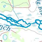
7 Case Study A: Isolate a single continuous centerline Pomme de Terre River, Missouri humid - hilly We are almost there

8 Pomme de Terre, MO NHD 24K humid - hilly 3. Prune and simplify flowlines 1. Select and simplify waterbodies and areas 2. Primary and secondary centerlines
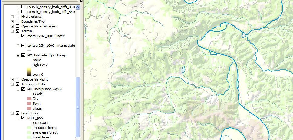
9 Draft result MO 50K LoD mapped at 100K High resolution (24K NHD) Derived 50K LoD

10 Validation Medium resolution (100K NHD) Derived 50K LoD

11 Missouri series with data from The National Map 24K map ArcGIS to JPEG to screen capture

12 Missouri, 50K map with 24K hydro Missouri 50K map with 24K hydro
13 Missouri, 50K map with 50K LoD Missouri 50K map with 50K LoD hydro Visual evaluation of hydro in map context

14 Missouri 50K LoD and original 24K hydro

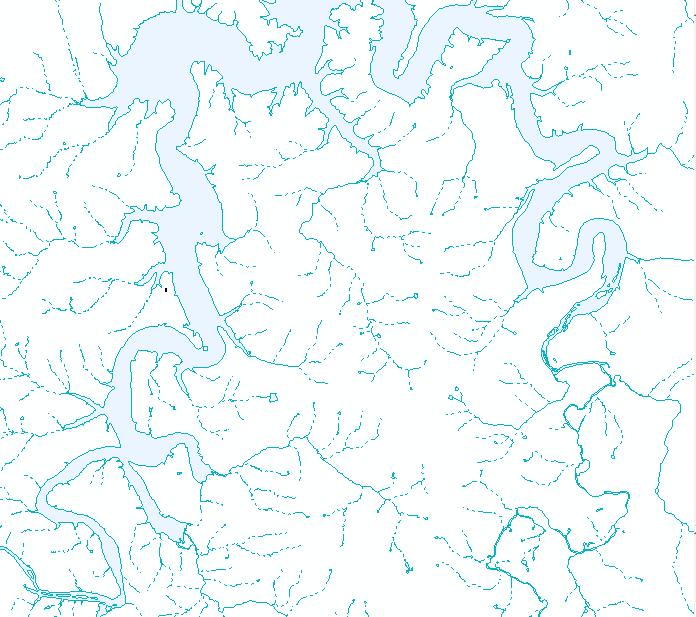
15 Case Study B: Identify NHD Flowlines by local density South Branch Potomac River, West Virginia humid - mountainous


16 What is meant by local density

17 S. Br. Potomac, WV NHD 24K humid - mountainous 1. Prune differentially, merge, build diffs_file 3. Isolate non-centerline flowlines Pruning criterion: 4. Simplify 2. Intersect NHD flowlines with NHD areas / waterbodies to delineate centerlines Summed remaining stream channel length Summed original catchment area
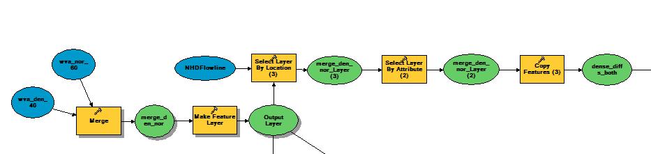
18 1. Prune differentially, merge, build diffs_file

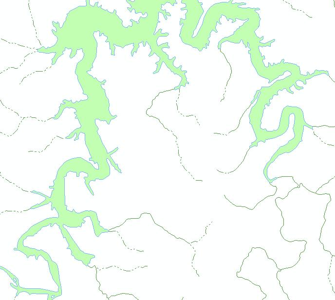
19 Draft result WV 50K LoD mapped At 100K: With original 24K hydro With derived 50K LoD
20 Draft result WV 50K LoD mapped At 100K: With original 100K hydro With derived 50K LoD

21 West Virginia series from TNM 24K West Virginia series with data from The National Map 24K map

22 West Virginia, 80K West Virginia 80K

23 West Virginia, 200K West Virginia 200K

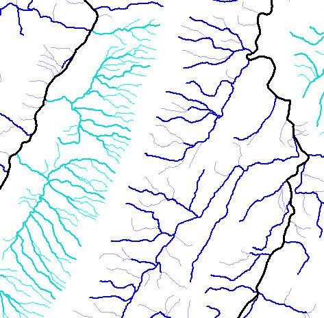
24 Case Study C: Isolate local textures from NHD Areas and Waterbodies Upper Suwannee River, Florida-Georgia humid - flat

25 Upper Suwannee, FL-GA NHD 24K humid - flat 1. Swamp / Marsh 2. Lakes / Ponds

26 1. Swamp/ Marsh

27 1. Swamp/ Marsh
28 Florida-Georgia, 80K map with 24K hydro Florida-Georgia, 80K map with 24K hydro

29 Florida-Georgia, 80K map with 50K LoD Florida-Georgia, 80K map with 50K LoD hydro

30 The National Map: eight themes elevation land use / land cover boundaries transportation structures hydrography geographic names orthoimagery nationalmap.gov C. Brewer et al. New Viewer announced for December ICC2009, November 2009
31 Practical considerations in design development No custom edits on TNM data (no clean up) Simple geometric symbols, so no missing fonts or pictures on export Regular fonts for export and file sharing (vs. USGS look with Souvenir and Univers) Lots of group layers to easily turn off categories while evaluating appearance All rasters and layers with transparency at bottom of TOC so export retains editable vectors and type No over/under passing on bridges and ramps (user may query this detail using GeoPDF click out to Google)
32 Color contrasts Red roads vs brown contours use gray contours
33 Color contrasts Red roads vs brown contours use gray contours All colors lighter than black labels few halos (only blue hydro labels and green reservation labels use halos)
34 Color contrasts Red roads vs brown contours use gray contours All colors lighter than black labels few halos (only blue hydro labels and green reservation labels use halos) This is not a road map do not use whole contrast range on road categories
35 Color contrasts Red roads vs brown contours use gray contours All colors lighter than black labels few halos (only blue hydro labels and green reservation labels use halos) This is not a road map do not use whole contrast range on road categories Contrasting outlines on point symbols separate from each other and background
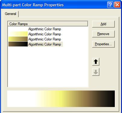
36 Color contrasts Red roads vs brown contours use gray contours All colors lighter than black labels few halos (only blue hydro labels and green reservation labels use halos) This is not a road map do not use whole contrast range on road categories Contrasting outlines on point symbols separate from each other and background Leave contrast available for update and overlay of operational information magenta could be used for additions if no magenta symbols
37 Systematic color categories for symbols Human themes: points: emergency hospitals schools transportation built-up areas Rd Or Pu admin reserves hillshade Br Gy Yl YG Cy Gn Natural themes: wooded areas forest reserves parks boundaries Bu hydrography


38 Systematic color categories for symbols Human themes: points: emergency hospitals schools transportation built-up areas Rd Or Pu admin reserves hillshade Br Gy Yl YG Cy Gn Natural themes: wooded areas forest reserves parks boundaries Bu hydrography


39 24K 100K Multiscale durability: good point overlaps
 Intermittent and perennial symbolized Label with a paired")

40 Hydrography Tapered by symbolizing upstream drainage area (stream order not useful) Intermittent and perennial symbolized Label with a paired layer, classed differently (not symbolized) More level-of-detail (LoD) databases in development (if 50K LoD covers , does 200K LoD cover ?)

41 Representing stream hierarchy Class upstream drainage area attribute and represent by width and color

42 Stream tapering Width (pts) RGB lighter ,180, ,180,200 med blue ,165, ,165,200 darker ,150, ,150,200
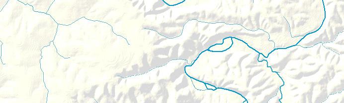
43 Multicolor hillshade with transparency
44 Additional work Generalization sequences for additional landscapes: settlement patterns (rural vs. urbanized) and coastal Tailor generalization algorithms, parameters, sequences to landscape types Decide the smallest number of tailored solutions that will apply to any generalization situation, nationally. Confirm they are not interchangeable through testing Test topo designs in multiple formats (ArcGIS, GeoPDF, cached tiles for web services, print) and multiple resolutions (print, 96 ppi desktop, 130+ ppi laptop)
45 Funding acknowledgements USGS Center of Excellence for Geospatial Information Science (CEGIS) Funded through Department of Interior CESU program, January 2007 to present Resources Project resources: ScaleMaster.org Lynn s Center: cegis.usgs.gov Cindy s website: babs Meridian Lab: greenwich.colorado.edu
Place Still Matters: Generalizing the NHD by Local Terrain and Climate
 Place Still Matters: Generalizing the NHD by Local Terrain and Climate Barbara Buttenfield, Geography, CU-Boulder Cynthia Brewer, Geography, Penn State E. Lynn Usery, USGS-CEGIS Research Assistants: Chris
Evaluation of Map Symbols by Screen Resolution and File Format Through Scale
 Evaluation of Map Symbols by Screen Resolution and File Format Through Scale Cynthia Brewer and Chelsea Hanchett, Penn State Barbara Buttenfield, Boulder Lawrence Stanislawski, CEGIS Penn State Research
Performance of Map Symbol and Label Design with Format and Display Resolution Options Through Scale for The National Map
 Performance of Map Symbol and Label Design with Format and Display Resolution Options Through Scale for The National Map Cynthia A. Brewer, Pennsylvania State University Chelsea L. Hanchett, Penn State
Multiple Representations of Geospatial Data: A Cartographic Search for the Holy Grail?
 Multiple Representations of Geospatial Data: A Cartographic Search for the Holy Grail? Barbara P. Buttenfield University of Colorado Boulder Research Faculty Affiliate, USGS-CEGIS babs@colorado.edu 13
Design for multiscale topographic mapping with minimal generalization
 Design for multiscale topographic mapping with minimal generalization Cynthia A. Brewer Department of Geography, Pennsylvania State University, University Park, PA, 16802, USA cbrewer@psu.edu Extended
Performance of Map Symbol and Label Design with Format and Display Resolution Options Through Scale for The National Map
 Performance of Map Symbol and Label Design with Format and Display Resolution Options Through Scale for The National Map Follow-up on AutoCarto 2011 talk Cynthia A. Brewer, Pennsylvania State University
Multiscale Representations of Water: Tailoring Generalization Sequences to Specific Physiographic Regimes
 Multiscale Representations of Water: Tailoring Generalization Sequences to Specific Physiographic Regimes Barbara P. Buttenfield 1, Lawrence V. Stanislawski 2, Cynthia A. Brewer 3 1 Department of Geography,
Establishing Classification and Hierarchy in Populated Place Labeling for Multiscale Mapping for The National Map
 Establishing Classification and Hierarchy in Populated Place Labeling for Multiscale Mapping for The National Map Wesley Stroh, Stephen Butzler and Cynthia Brewer Gould Center, Geography Pennsylvania State
ScaleMaster characterization of types of design change through scale for mapping from multi-resolution databases
 ScaleMaster characterization of types of design change through scale for mapping from multi-resolution databases Cynthia A. Brewer, Pennsylvania State University Jessica Acosta, Penn State ESRI Barbara
Assessment of a Rapid Approach for Estimating Catchment Areas for Surface Drainage Lines
 Assessment of a Rapid Approach for Estimating Catchment Areas for Surface Drainage Lines U.S. Geological Survey Center of Excellence for Geospatial Information Science 1400 Independence Road, Rolla Missouri,
Introduction. Background
 Multi-resolution Multi-scale Topographic Map Design: Toward a New Look for The National Map Cynthia A. Brewer and Mamata K. Akella ABSTRACT: The pilot study reported here examined the effects on map readability
COMPARISON OF TOPOGRAPHIC MAP DESIGNS FOR OVERLAY ON ORTHOIMAGE BACKGROUNDS
 CO-475 COMPARISON OF TOPOGRAPHIC MAP DESIGNS FOR OVERLAY ON ORTHOIMAGE BACKGROUNDS RAPOSO P.J., BREWER C.A. Penn State University, STATE COLLEGE, UNITED STATES INTRODUCTION This paper reports the findings
Establishing Classification and Hierarchy in Populated Place Labeling for Multiscale Mapping for The National Map
 Establishing Classification and Hierarchy in Populated Place Labeling for Multiscale Mapping for The National Map Stephen Butzler, Cynthia Brewer and Jim Thatcher RA: Doug Minnigh Gould Center, Geography
What s New in Topographic Information - USGS National Map
 + What s New in Topographic Information - USGS National Map SARGIS Workshop November 14, 2016 Rob Dollison, 703-648-5724 rdollison@usgs.gov + USGS 2 National Geospatial Program The National Geospatial
National Hydrography Dataset (NHD) Update Project for US Forest Service Region 3
 Update Project for US Forest Service Region 3") National Hydrography Dataset (NHD) Update Project for US Forest Service Region 3 Allison Moncada California State University, Northridge February 2017 July 2017 Advisor: Joel Osuna Center for Geographical
National Hydrography Dataset (NHD) Update Project for US Forest Service Region 3 Allison Moncada California State University, Northridge February 2017 July 2017 Advisor: Joel Osuna Center for Geographical
Improvement of the National Hydrography Dataset for Parts of the Lower Colorado Region and Additional Areas of Importance to the DLCC
 Improvement of the National Hydrography Dataset for Parts of the Lower Colorado Region and Additional Areas of Importance to the DLCC Carlos Reyes-Andrade California State University, Northridge September
Hydrologically Consistent Pruning of the High- Resolution National Hydrography Dataset to 1:24,000-scale
 Hydrologically Consistent Pruning of the High- Resolution National Hydrography Dataset to 1:24,000-scale Lawrence V. Stanislawski 1, Ariel Doumbouya 2, Barbara P. Buttenfield 3, 1 Center for Excellence
Watershed Analysis of the Blue Ridge Mountains in Northwestern Virginia
 Watershed Analysis of the Blue Ridge Mountains in Northwestern Virginia Mason Fredericks December 6, 2018 Purpose The Blue Ridge Mountain range is one of the most popular mountain ranges in the United
Mastering Map Scale: Formalizing Guidelines for Multi-Scale Map Design
 Mastering Map Scale: Formalizing Guidelines for Multi-Scale Map Design Cynthia A. Brewer Pennsylvania State University Barbara P. Buttenfield University of Colorado Boulder a.k.a. Cindy and babs Collaborators
USGS QUADRANGLES IN GOOGLE EARTH
 USGS QUADRANGLES IN GOOGLE EARTH By Thomas G. Davis 1, PhD, PE, PLS and Rollins Turner 2, PhD INTRODUCTION QUADS (http://www.metzgerwillard.us/quads/) is a web-based service for visualizing USGS quadrangle
NATIONAL HYDROGRAPHY DATASET (NHD) UPDATE PROJECT FOR US FOREST SERVICE REGION 3
 UPDATE PROJECT FOR US FOREST SERVICE REGION 3") NATIONAL HYDROGRAPHY DATASET (NHD) UPDATE PROJECT FOR US FOREST SERVICE REGION 3 Allison Moncada California State University, Northridge February 2018 July 2018 Advisor: Joel Osuna Center for Geospatial
NATIONAL HYDROGRAPHY DATASET (NHD) UPDATE PROJECT FOR US FOREST SERVICE REGION 3 Allison Moncada California State University, Northridge February 2018 July 2018 Advisor: Joel Osuna Center for Geospatial
An Information Model for Maps: Towards Cartographic Production from GIS Databases
 An Information Model for s: Towards Cartographic Production from GIS Databases Aileen Buckley, Ph.D. and Charlie Frye Senior Cartographic Researchers, ESRI Barbara Buttenfield, Ph.D. Professor, University
The National Hydrography Dataset in the Pacific Region. U.S. Department of the Interior U.S. Geological Survey
 The National Hydrography Dataset in the Pacific Region U.S. Department of the Interior U.S. Geological Survey The National Map The National Map is built on partnerships and standards The National Map consists
StreamStats: Delivering Streamflow Information to the Public. By Kernell Ries
 StreamStats: Delivering Streamflow Information to the Public By Kernell Ries U.S. Department of the Interior U.S. Geological Survey MD-DE-DC District 410-238-4317 kries@usgs.gov StreamStats Web Application
GeoWEPP Tutorial Appendix
 GeoWEPP Tutorial Appendix Chris S. Renschler University at Buffalo - The State University of New York Department of Geography, 116 Wilkeson Quad Buffalo, New York 14261, USA Prepared for use at the WEPP/GeoWEPP
Multiple Representations of Geospatial Data: A Cartographic Search for the Holy Grail
 Multiple Representations of Geospatial Data: A Cartographic Search for the Holy Grail Barbara P. Buttenfield University of Colorado, Boulder babs@colorado.edu Collaboration with Cindy Brewer, Penn State
Preparing a NFIE-Geo Database for Travis County
 Preparing a NFIE-Geo Database for Travis County By David R. Maidment Center for Research in Water Resources University of Texas at Austin 2 February 2015 Contents Introduction... 1 Step 1. Download and
Aileen Buckley, Ph.D. and Charlie Frye
 An Information Model for Maps: Towards Production from GIS Databases Aileen Buckley, Ph.D. and Charlie Frye Researchers, ESRI GIS vs. cart GIS Outline of the presentation Introduction Differences between
Summary Description Municipality of Anchorage. Anchorage Coastal Resource Atlas Project
 Summary Description Municipality of Anchorage Anchorage Coastal Resource Atlas Project By: Thede Tobish, MOA Planner; and Charlie Barnwell, MOA GIS Manager Introduction Local governments often struggle
ArcGIS Tools for Professional Cartography
 ArcGIS Tools for Professional Cartography By Makram Murad-al-shaikh M.S. Cartography Senior instructor ESRI Educational Services ICC - A Coruña - Spain, 9-16 July, 2005 Overview Overview of the ArcGIS
Within this document, the term NHDPlus is used when referring to NHDPlus Version 2.1 (unless otherwise noted).
.") Exercise 7 Watershed Delineation Using ArcGIS Spatial Analyst Last Updated 4/6/2017 Within this document, the term NHDPlus is used when referring to NHDPlus Version 2.1 (unless otherwise noted). There
Exercise 7 Watershed Delineation Using ArcGIS Spatial Analyst Last Updated 4/6/2017 Within this document, the term NHDPlus is used when referring to NHDPlus Version 2.1 (unless otherwise noted). There
NR402 GIS Applications in Natural Resources
 NR402 GIS Applications in Natural Resources Lesson 1 Introduction to GIS Eva Strand, University of Idaho Map of the Pacific Northwest from http://www.or.blm.gov/gis/ Welcome to NR402 GIS Applications in
USGS Community Engagement and its Role in Improving The National Map
 USGS Community Engagement and its Role in Improving The National Map ESRI User Conference, 2014 Bob Davis Carol Ostergren Drew Decker USGS Strategic Direction Provides a sharpened focus on our topographic
Proceedings - AutoCarto Columbus, Ohio, USA - September 16-18, 2012
 Automated Metric Assessment of Line Simplification in Humid Landscapes Lawrence V. Stanislawski 1, Paulo Raposo 2, Michael Howard 1, and Barbara P. Buttenfield 3 1 Center for Excellence in Geospatial Information
Improvement of the National Hydrography Dataset for US Forest Service Region 3 in Cooperation with the National Forest Service
 Improvement of the National Hydrography Dataset for US Forest Service Region 3 in Cooperation with the National Forest Service Christian L. DeCasas California State University, Northridge November 7 th,
Development and Land Use Change in the Central Potomac River Watershed. Rebecca Posa. GIS for Water Resources, Fall 2014 University of Texas
 Development and Land Use Change in the Central Potomac River Watershed Rebecca Posa GIS for Water Resources, Fall 2014 University of Texas December 5, 2014 Table of Contents I. Introduction and Motivation..4
Outcrop suitability analysis of blueschists within the Dry Lakes region of the Condrey Mountain Window, North-central Klamaths, Northern California
 Outcrop suitability analysis of blueschists within the Dry Lakes region of the Condrey Mountain Window, North-central Klamaths, Northern California (1) Introduction: This project proposes to assess the
Local Government Basemaps using ArcGIS
 Local Government Basemaps using ArcGIS Steve Grisé Scott Oppmann Tuesday, July 14, 10:15-11:30am SDCC 30B Topics Basemaps for Local Government Essential Application-Driven New Ideas Design Strategies Discussion
USGS National Hydrography Dataset (NHD) and NHDPlus
 and NHDPlus") + 1 + USGS National Hydrography Dataset (NHD) and NHDPlus Al Rea USGS National Geospatial Program Western States Water Council August 1, 2018 + 2 USGS National Hydrography Datasets Hydrologic networks,
+ 1 + USGS National Hydrography Dataset (NHD) and NHDPlus Al Rea USGS National Geospatial Program Western States Water Council August 1, 2018 + 2 USGS National Hydrography Datasets Hydrologic networks,
So, in this presentation, you can sit back and focus on the concepts and
 CHARLIE 15 MINUTES ABSTRACT In this session, we show how you can use a map template and other resources from the Resource Centers to complete your work faster and easier. We will touch on managing and
ROAD SEDIMENT ASSESSMENT & MODELING: KOOTENAI-FISHER TMDL PLANNING AREA ROAD GIS LAYERS & SUMMARY STATISTICS
 ROAD SEDIMENT ASSESSMENT & MODELING: KOOTENAI-FISHER TMDL PLANNING AREA ROAD GIS LAYERS & SUMMARY STATISTICS Prepared by: ATKINS Water Resources Group 820 North Montana Avenue Helena, MT 59601 November
Welcome to NR502 GIS Applications in Natural Resources. You can take this course for 1 or 2 credits. There is also an option for 3 credits.
 Welcome to NR502 GIS Applications in Natural Resources. You can take this course for 1 or 2 credits. There is also an option for 3 credits. The 1st credit consists of a series of readings, demonstration,
Stream Correction for Local Government GIS
 Stream Correction for Local Government GIS A Practical Guide and Introduction Nicholas McKenny Penn State Adviser: James O'Brien 1/16 Presentation Outline Existing Situation Solution, Goals, & Hopes Guide
USGS National Geospatial Program Understanding User Needs. Dick Vraga National Map Liaison for Federal Agencies July 2015
 + USGS National Geospatial Program Understanding User Needs Dick Vraga National Map Liaison for Federal Agencies July 2015 + Topics 2 Background Communities of Use User Surveys National Map Liaisons Partnerships
A GIS-based Approach to Watershed Analysis in Texas Author: Allison Guettner
 Texas A&M University Zachry Department of Civil Engineering CVEN 658 Civil Engineering Applications of GIS Instructor: Dr. Francisco Olivera A GIS-based Approach to Watershed Analysis in Texas Author:
Hydrology and Watershed Analysis
 Hydrology and Watershed Analysis Manual By: Elyse Maurer Reference Map Figure 1. This map provides context to the area of Washington State that is being focused on. The red outline indicates the boundary
Ladder versus star: Comparing two approaches for generalizing hydrologic flowline data across multiple scales. Kevin Ross
 Ladder versus star: Comparing two approaches for generalizing hydrologic flowline data across multiple scales Kevin Ross kevin.ross@psu.edu Paper for Seminar in Cartography: Multiscale Hydrography GEOG
EnvSci 360 Computer and Analytical Cartography
 EnvSci 360 Computer and Analytical Cartography Lecture 7 Mapping Images, Surfaces, and 3-D Data Brief Overview of Imagery What is Imagery? A spatial data model that defines space as an array of equally
Louisiana Transportation Engineering Conference. Monday, February 12, 2007
 Louisiana Transportation Engineering Conference Monday, February 12, 2007 Agenda Project Background Goal of EIS Why Use GIS? What is GIS? How used on this Project Other site selection tools I-69 Corridor
What's New with NHDPlus (Classic)?
?") What's New with NHDPlus (Classic)? 1987 Reach File Version 1 2017 - NHDPlus Annie Mejaes EPA, Office of Water 2 Overview NHD-NHDPlus Basics Evolving NHD-NHDPlus Data and Tools Training and Support The
What's New with NHDPlus (Classic)? 1987 Reach File Version 1 2017 - NHDPlus Annie Mejaes EPA, Office of Water 2 Overview NHD-NHDPlus Basics Evolving NHD-NHDPlus Data and Tools Training and Support The
Designing a Dam for Blockhouse Ranch. Haley Born
 Designing a Dam for Blockhouse Ranch Haley Born CE 394K GIS in Water Resources Term Paper Fall 2011 Table of Contents Introduction... 1 Data Sources... 2 Precipitation Data... 2 Elevation Data... 3 Geographic
SoilView: Development of a Custom GIS Application for Publishing Soil Surveys
 SoilView: Development of a Custom GIS Application for Publishing Soil Surveys Allan Johnson and Mike Wigginton Abstract Currently, digital soils information can be obtained from many sources. Numerous
 estrandh@uoregon.edu Introduction The general topic of this paper describes a unique cartographic project depicting a mountain landscape for the Friends of Opal Creek (F.O.C.), a non-profit organization.
Delineation of high landslide risk areas as a result of land cover, slope, and geology in San Mateo County, California
 Delineation of high landslide risk areas as a result of land cover, slope, and geology in San Mateo County, California Introduction Problem Overview This project attempts to delineate the high-risk areas
software, just as word processors or databases are. GIS was originally developed and cartographic capabilities have been augmented by analysis tools.
 1. INTRODUCTION 1.1Background A GIS is a Geographic Information System, a software package for creating, viewing, and analyzing geographic information or spatial data. GIS is a class of software, just
Topographic Maps. Take Notes as you view the slides
 Topographic Maps Take Notes as you view the slides Lesson Objectives Define a topographic map and state its uses. Describe how contour lines show the elevations, shape, and slope of the land. Identify
Lidar-derived Hydrography as a Source for the National Hydrography Dataset
 Lidar-derived Hydrography as a Source for the National Hydrography Dataset Lidar-Derived Hydrography, Bathymetry, and Topobathymetry in the National Hydrography Dataset and 3-Dimensional Elevation Program
Designing GIS Databases to Support Mapping and Map Production Charlie Frye, ESRI Redlands Aileen Buckley, ESRI Redlands
 Designing GIS Databases to Support Mapping and Map Production Charlie Frye, ESRI Redlands Aileen Buckley, ESRI Redlands 1 Designing GIS Databases to Support Mapping and Map Production Charlie Frye, ESRI
Delineation of Watersheds
 Delineation of Watersheds Adirondack Park, New York by Introduction Problem Watershed boundaries are increasingly being used in land and water management, separating the direction of water flow such that
USGS Hydrography Overview. May 9, 2018
 + 1 USGS Hydrography Overview May 9, 2018 + 2 The National Geospatial Program Provides the geospatial baseline of the Nation s topography, natural landscape and built environment through The National Map,
Topographic Maps. More than a Road Map
 Topographic Maps More than a Road Map What is a Topographic Map? Scaled representation of features on the surface of the Earth such as roads, rivers, and plains Provides information about land elevations
A Simple Drainage Enforcement Procedure for Estimating Catchment Area Using DEM Data
 A Simple Drainage Enforcement Procedure for Estimating Catchment Area Using DEM Data David Nagel, John M. Buffington, and Charles Luce U.S. Forest Service, Rocky Mountain Research Station Boise Aquatic
DATA APPLIANCE FOR ARCGIS
 DATA APPLIANCE FOR ARCGIS Data Appliance for ArcGIS Provides Access to Multi-Scale Basemaps Down to Medium Scale Levels Worldwide And Large Scale for Most of the World The Data Appliance includes Several
Welcome to NetMap Portal Tutorial
 Welcome to NetMap Portal Tutorial Potential Applications What Can you do with the Portal? At least 25 things! 1) Locate the best potential fish habitats. 2) Identify biological hotspots. 3) Map floodplain
Leveraging LiDAR for Statewide NHD Hydrography Projects. Susan Phelps, CFM, GISP
 Leveraging LiDAR for Statewide NHD Hydrography Projects Susan Phelps, CFM, GISP Mon, July 11 th, 2016 National Hydrography Dataset (NHD) Background Why Local-Res NHD? Drivers Include: Availability of accurate
Hydrography Webinar Series
 Hydrography Webinar Series Session 2 May 21, 2015 U.S. Department of the Interior U.S. Geological Survey U.S. GEOLOGICAL SURVEY HYDROGRAPHY WEBINAR SERIES Hosted by: Jeff Simley Al Rea Hydrography Webinar
Topographic Maps and Landforms Geology Lab
 Topographic Maps and Landforms Geology Lab Ray Rector: Instructor Today s Lab Activities 1) Discussion of Last Week s Lab 2) Lecture on Topo Maps and Elevation Contours 3) Construct Topographic Maps and
Geospatial Data Sources. SLO GIS User Group June 8, 2010
 Geospatial Data Sources SLO GIS User Group June 8, 2010 Presenters Drew Decker USGS Southern California Geospatial Liaison Kelly Bobbitt Mike Bobbitt & Associates Joe Larson Cal Fire Peter Meertens Regional
Cartography: Modeling GIS data for Mapmaking. Aileen Buckley, Ph.D. Senior Cartographic Researcher, ESRI. Barbara Buttenfield, Ph.D.
 Slide 1 Cartography: Modeling GIS data for Mapmaking Aileen Buckley, Ph.D. Senior Cartographic Researcher, ESRI Barbara Buttenfield, Ph.D. Professor, University of Colorado-Boulder Thank you coming to
3D Elevation Program- Status and Updates. Oklahoma GI Council Meeting November 2, 2018 Claire DeVaughan US Geological Survey
 + 1 3D Elevation Program- Status and Updates Oklahoma GI Council Meeting November 2, 2018 Claire DeVaughan US Geological Survey + 2 3D Elevation Program (3DEP) Goals Complete acquisition in 8 years Address
A Help Guide for Using gssurgo to Find Potential Wetland Soil Landscapes
 A Help Guide for Using gssurgo to Find Potential Wetland Soil Landscapes Wetland Mapping Consortium Webinar September 17, 2014 Dr. John M. Galbraith Crop & Soil Environmental Sciences Virginia Tech Wetland
The National Map Data Delivery Services
 The National Map Data Delivery Services U.S. Department of the Interior U.S. Geological Survey April 2015 Jim Langtry jlangtry@usgs.gov Topics for Today The National Map Delivery Services The National
Esri s Living Atlas of the World Community Maps
 Esri s Living Atlas of the World Community Maps Seth Sarakaitis Wednesday May 7, 2014 ArcGIS Living Atlas Concept Living Atlas Content Tour Contributing to the Living Atlas (Community Maps) Seth Sarakaitis
GRAPEVINE LAKE MODELING & WATERSHED CHARACTERISTICS
 GRAPEVINE LAKE MODELING & WATERSHED CHARACTERISTICS Photo Credit: Lake Grapevine Boat Ramps Nash Mock GIS in Water Resources Fall 2016 Table of Contents Figures and Tables... 2 Introduction... 3 Objectives...
Using the Stock Hydrology Tools in ArcGIS
 Using the Stock Hydrology Tools in ArcGIS This lab exercise contains a homework assignment, detailed at the bottom, which is due Wednesday, October 6th. Several hydrology tools are part of the basic ArcGIS
Using ArcGIS for Hydrology and Watershed Analysis:
 Using ArcGIS 10.2.2 for Hydrology and Watershed Analysis: A guide for running hydrologic analysis using elevation and a suite of ArcGIS tools Anna Nakae Feb. 10, 2015 Introduction Hydrology and watershed
GIS in Water Resources Midterm Exam Fall 2008 There are 4 questions on this exam. Please do all 4.
 Page 1 of 8 Name: GIS in Water Resources Midterm Exam Fall 2008 There are 4 questions on this exam. Please do all 4. 1. Basic Concepts [20 points] Find the letter with the best answer for each term: 1.
Display data in a map-like format so that geographic patterns and interrelationships are visible
 Vilmaliz Rodríguez Guzmán M.S. Student, Department of Geology University of Puerto Rico at Mayagüez Remote Sensing and Geographic Information Systems (GIS) Reference: James B. Campbell. Introduction to
Rick Faber CE 513 Watershed and Streamwork Delineation Lab # 3 4/24/2006
 Rick Faber CE 513 Watershed and Streamwork Delineation Lab # 3 4/24/2006 1. Objective & Discussion: 2 To learn to use the ArcHydro tools to produce hydrologically descriptive data sets starting from a
Indiana GIS Local Resolution NHD Applications. Indiana State GIS Conference
 Indiana GIS Local Resolution NHD Applications Indiana State GIS Conference May 7, 2013 Agenda Topics I. Indiana s National Hydrography y Data II. Accessing NHD Data III. Demonstrations Using Local NHD
THE DIGITAL TERRAIN MAP LIBRARY: AN EXPLORATIONIST S RESOURCE
 THE DIGITAL TERRAIN MAP LIBRARY: AN EXPLORATIONIST S RESOURCE By I.C.L. Webster, P.J. Desjardins and W.E. Kilby KEYWORDS: digital terrain maps, digital terrain stability maps, surficial geology, GIS, raster
Introducing Iowa StreamStats Version 4, a Redesign of the USGS Application for Estimating Streamflow Stats
 Introducing Iowa StreamStats Version 4, a Redesign of the USGS Application for Estimating Streamflow Stats Presented at the 2016 Iowa Water Conference Ames, IA March 24, 2016 by David Eash U.S. Geological
8 th 12 th Designing a Monitoring Plan Mapping & Analysis (Activities 1 2)
") 8 th 12 th Designing a Monitoring Plan Mapping & Analysis (Activities 1 2) Objectives for All Activities - To be able to define and describe the purpose and uses of topographic maps. - To define rules
8 th 12 th Designing a Monitoring Plan Mapping & Analysis (Activities 1 2) Objectives for All Activities - To be able to define and describe the purpose and uses of topographic maps. - To define rules
Lauren Jacob May 6, Tectonics of the Northern Menderes Massif: The Simav Detachment and its relationship to three granite plutons
 Lauren Jacob May 6, 2010 Tectonics of the Northern Menderes Massif: The Simav Detachment and its relationship to three granite plutons I. Introduction: Purpose: While reading through the literature regarding
USGS POD implementation in USGS Cloud to Support US Topo Production
 USGS POD implementation in USGS Cloud to Support US Topo Production 2017 Esri User Conference 16 June 2017 Bob Davis lrdavis@usgs.gov 573-308-3554 William J. Marken, GSP wmarken@usgs.gov 573-308-3532 U.S.
Lecture 9: Reference Maps & Aerial Photography
 Lecture 9: Reference Maps & Aerial Photography I. Overview of Reference and Topographic Maps There are two basic types of maps? Reference Maps - General purpose maps & Thematic Maps - maps made for a specific
4. GIS Implementation of the TxDOT Hydrology Extensions
 4. GIS Implementation of the TxDOT Hydrology Extensions A Geographic Information System (GIS) is a computer-assisted system for the capture, storage, retrieval, analysis and display of spatial data. It
Base Maps: Creating, Using & Participating
 Base Maps: Creating, Using & Participating Michael Fashoway & Erin Geraghty Montana Base Map Service Center 2010 MAGIP Technical Session October 28, 2010 What is a Base Map? Using a Base Map Creating a
Acknowledgments xiii Preface xv. GIS Tutorial 1 Introducing GIS and health applications 1. What is GIS? 2
 Acknowledgments xiii Preface xv GIS Tutorial 1 Introducing GIS and health applications 1 What is GIS? 2 Spatial data 2 Digital map infrastructure 4 Unique capabilities of GIS 5 Installing ArcView and the
ArcGIS Data Models: Raster Data Models. Jason Willison, Simon Woo, Qian Liu (Team Raster, ESRI Software Products)
") ArcGIS Data Models: Raster Data Models Jason Willison, Simon Woo, Qian Liu (Team Raster, ESRI Software Products) Overview of Session Raster Data Model Context Example Raster Data Models Important Raster
ArcGIS Data Models: Raster Data Models Jason Willison, Simon Woo, Qian Liu (Team Raster, ESRI Software Products) Overview of Session Raster Data Model Context Example Raster Data Models Important Raster
USING THE MILITARY LENSATIC COMPASS
 USING THE MILITARY LENSATIC COMPASS WARNING This presentation is intended as a quick summary, and not a comprehensive resource. If you want to learn Land Navigation in detail, either buy a book; or get
Geospatial Semantics for Topographic Data
 Geospatial Semantics for Topographic Data E. Lynn Usery U.S. Geological Survey Abstract. Whereas The National Map of the U.S. Geological Survey is based on data models and processes of geographic information
Pan-Arctic Digital Elevation Map (Pan-Arctic DEM)
") Memorandum to CAFF Board 07/28/2017 BACKGROUND: Pan-Arctic Digital Elevation Map (Pan-Arctic DEM) ArcticDEM is a National Geospatial-Intelligence Agency (NGA)-National Science Foundation (NSF) publicprivate
Memorandum to CAFF Board 07/28/2017 BACKGROUND: Pan-Arctic Digital Elevation Map (Pan-Arctic DEM) ArcticDEM is a National Geospatial-Intelligence Agency (NGA)-National Science Foundation (NSF) publicprivate
Harrison 1. Identifying Wetlands by GIS Software Submitted July 30, ,470 words By Catherine Harrison University of Virginia
 Harrison 1 Identifying Wetlands by GIS Software Submitted July 30, 2015 4,470 words By Catherine Harrison University of Virginia cch2fy@virginia.edu Harrison 2 ABSTRACT The Virginia Department of Transportation
Geo-spatial Analysis for Prediction of River Floods
 Geo-spatial Analysis for Prediction of River Floods Abstract. Due to the serious climate change, severe weather conditions constantly change the environment s phenomena. Floods turned out to be one of
Evaluating Physical, Chemical, and Biological Impacts from the Savannah Harbor Expansion Project Cooperative Agreement Number W912HZ
 Evaluating Physical, Chemical, and Biological Impacts from the Savannah Harbor Expansion Project Cooperative Agreement Number W912HZ-13-2-0013 FY 2016 - First Quarterly Report January 1, 2016 Submitted
IMPERIAL COUNTY PLANNING AND DEVELOPMENT
 IMPERIAL COUNTY PLANNING AND DEVELOPMENT GEODATABASE USER MANUAL FOR COUNTY BUSINESS DEVELOPMENT GIS June 2010 Prepared for: Prepared by: County of Imperial Planning and Development 801 Main Street El
Accuracy assessment of Pennsylvania streams mapped using LiDAR elevation data: Method development and results
 Accuracy assessment of Pennsylvania streams mapped using LiDAR elevation data: Method development and results David Saavedra, geospatial analyst Louis Keddell, geospatial analyst Michael Norton, geospatial
The production and use of a hydrographic flow-direction network of surface waters. Rickard HALLENGREN, Håkan OLSSON and Erik SISELL, Sweden
 The production and use of a hydrographic flow-direction network of surface waters Rickard HALLENGREN, Håkan OLSSON and Erik SISELL, Sweden Key words: hydrographic, flow-direction network, surface waters
ArcGIS Pro: Essential Workflows STUDENT EDITION
 ArcGIS Pro: Essential Workflows STUDENT EDITION Copyright 2018 Esri All rights reserved. Course version 6.0. Version release date August 2018. Printed in the United States of America. The information contained