Issues and resolutions - Decisions
|
|
|
- Peter Knight
- 5 years ago
- Views:
Transcription
 Using Technology to increase Government capacity and capability in Geo- Enabling Work-Flows for Transformation Map World Forum, Hyderabad")
1 GIS EANABLING TRANSFORMATION Issues and resolutions - Decisions Multi-Layer GIS for Digital Transformation ( Smart Governance & Planning and Decision-Making) Using Technology to increase Government capacity and capability in Geo- Enabling Work-Flows for Transformation Map World Forum, Hyderabad January,2017
2 National Informatics Centre - The Mandate Trusted Technology Partner of the Government Provide ICT Infrastructure on demand Design & Develop IT Systems for Government Explore & Advise on different dimensions of ICT in Government

3 Government ICT Infrastructure Setup by NIC Pan India Government Network Government LANs Data Centres Video Conferencing National Cloud Cyber Security SMS Gateway National Knowledge Network Webcast e-sign (in process) GIS

4 Major Products / Platforms eprocurement Vaahan & Saarthi eprison ServicePlus PFMS e-hospital MyGOV Elections eoffice esamiksha PRIASoft etaal Biometric Attendance CollabCAD Open Data More.

5 Major Projects ecourts Jeevan Pramaan TPDS Swachh Bharat Gramin National Scholarships Portal epanchayat IVFRT ecounselling Soil Health Card Land Records mfms NGO Portal More.
6 Digital India Digital India is a Programme to transform India into a digitally empowered society and knowledge National Informatics Centre 6
7 Vision of Digital India Centered around 3 Key Areas Digital Infrastructure as a Utility to Every Citizen Governance & Service on Demand Digital Empowerment of Citizen Asset Mapping Location Based Services Leveraging GIS For Decision Support Systems & Development GIS is a common technology platform and service cutting across key areas covered as Digital India Vision
8 Nine Pillars of Digital India 1. Broadband Highways 2. Universal Access to Phones 3. Public Access Internet Programme 4. e- Governance- Reforming Govt. through Technology 5. e- Kranti Electronic Delivery of Services 6. Information for All National GIS Mission for Digital India : GIS is a Technology for Planning, Decision-Making & Electronic 8. IT Delivery For Jobs of Services ( Pillar-5), Geo-enabling e-governance (Pillar-4) to facilitate location based information for all (Pillar- 6): 7. Electronics Manufacturing- Target NET ZERO Imports 8. IT for Jobs 9. Early Harvest Programme
9 Location as Primary Unit for Digital India Location - Important dimension in Network Connected Digital World of Information Highways. Geo-Tagging of Location of Assets, Infrastructure, Natural and Human Resources - Essential requirement to understand ground reality of development process & services to be made available to citizens. Geographical Information System (GIS) as Technology Platform to facilitate Location-Specific Governance & Services on Demand, as key implementation strategy for Knowledge Driven- Digital India. GIS to facilitate Planning, Decision-Support, Monitoring & Evaluation for Good Governance as well as Social Auditing of Government Action for Development with participation of citizens.
10 GIS as major E- (or G-) Governance Sub-System is an important lever to accelerate growth and increase focus in different domains Government Internal Security, Rural Development Financial Planning Infrastructure Agriculture Land Records Education Research, Higher Education Technologists Environment Climate Water, Land, Wildlife, Vegetation Natural Resources Agriculture, Forestry, Mining, Petroleum, Pipeline Utilities organizations Telecom Power Management, Electricity Gas Water and Waste management Businesses Banking, Logistics, Real Estate, Retail, Media Digital India demands Sustainable Framework for Location Based Services for Good Governance to fulfill the aspirations of Citizens of the country.

11 Multi-Layer GIS Platform A standards based framework to deploy Digital GIS Assets Represents common intent of major ministries/departments Part of larger e-gov initiatives to support backend governance applications Facilitate real-time update through departmental ownership and driving force Involvement and participation of citizens through crowd-sourcing e-gov applications to drive Location Based Services and facilitate use of Maps through Apps within the work-flow and process of governance needs Integration with Social Media for data authentication and social auditing National Informatics Centre 11
12 GIS Initiatives Enabling Digital Transformation Bharat Maps Multi-Layer GIS Platform GIS for Financial Inclusion (DBT-GIS Portal) BBNL GIS Portal (Bharat Broadband Network Limited) BharatNet Project Monitoring (National Optical Fiber Network, BBNL) School Location Mapping (School GIS) Utility Mapping Smart Cities Punjab GIS An Example of Collaborative Mapping National Informatics Centre 12
13 Bharat Maps Bharat Maps is a multi layered GIS platform/web service comprising of seamless country wide base maps, satellite images and hybrid maps aligned as per the global geo-spatial standards, it is an essential component of Digital India program to ensure easy governance, effective governance and economical governance. It would provide GIS based decision support system to central/state government departments for delivering citizen centric services. Salient features A robust and scalable framework based on service oriented architecture (SOA). Incorporated OGC standards based spatial data repository. Tiled base maps at 14 different scales up to 1:4K Seamless mosaics of IRS images of varying resolutions like AWiFS (56m), LISS-III (23.5m) and PAN (5.80m). Terrain Base Map service featuring shaded relief imagery. Leveraging addition content with external global services using mash ups. Rich Internet Application (RIA) with cross platform support based on open API s like Flex and JavaScript. Linkage to attribute data like census etc. Spatial Data (Layers) National/State/District/Block Village Location State HQ, District HQ, Sub District HQ and Panchayat HQ Location. Census Village Location and Habitations Settlements and footprints Roads, Railway Lines and Stations Airports Surface Water Features Historical Places National Parks National Informatics Centre Functionalities Map Viewer with GIS Navigation Tools (Zoom In, Zoom Out, Pan and Full Extent) Identify Table of Content Measure Base map Gallery Bookmark Legend Print Area of Interest Geo-Code Locator Search Upload and view CSV Swipe/Spotlight Tool Elevation Profile 13


14 Bharat Maps National Informatics Centre 14
15 Objective GIS for Financial Inclusion (DBT-GIS Web Portal) GIS for Financial Inclusion is a web application of mapping of financial infrastructure across the country to facilitate the financial inclusion of rural masses so that the Direct Benefit Transfer can reach the unreached Future Road Map Citizen Service to people to find out financial services in their neighborhoods. Bringing value-added analytical services as per the needs of various stakeholders to facilitate advanced Decision Support System (DSS) for financial inclusion. Features Framework Spatial Data Services Robust & Scalable framework based on (SOA) Service Oriented Architecture Spatial Data (Layers) State/District/Block Boundaries Village Location Bank Assets Bank Branch ATM Bank Mitra CSC Post Offices Assets GPO HPO SO BO National Informatics Centre Mobile Tower Stakeholders DBT Mission Directorate Dept. of Financial Services Dept. of Electronics & IT Dept. of Post Linkage of attribute data of financial institution, Post Offices, etc. GIS Functionalities :- Standard GIS Navigational Tools Layer Legend List ESRI ArcGIS Online (Street, Topo, Aerial) Base map Toggling Identify Distance Measurement Area of Interest Navigation & Statistics Search Buffer Proximity Analysis Print Access in Government to Government (G2G) domain 15
 Financial")
 -")
 - Digital Payments")

16 GIS for Financial Inclusion (DBT-GIS Web Portal) Financial Inclusion Platforms - Public Finance Management System (PFMS) - Bharatkosh (Non-Receipt Tax Receipt Portal) - Digital Payments (through apps, Addhar Seeding, E-wallet, UPI, USSD etc.) National Informatics Centre 16
17 Data Layer Application Layer Application for Integrating with NMS/OSS High Level View for BBNL GIS Data Viewing Data Editing Dash Board MIS App. Mobile App. Thematic App. Internal Users User Authentication Role base access Report Generation & Analysis NMS Server - BBNL - DOT - PSU s Data Preparation & Processing CRM Server External Users - Other Government Department/ Ministries Network Layer (OSP) Existing OFC Layer Route Survey Layer Actual Network (After Survey) Updated Network after Commissioning Network Attributes (Only OSP Related) Billing Server ERP Server - Common Citizen Base Layer Bhuvan Map Service External global Map Services Limited Satellite Images for critical areas Existing Multi-layer GIS framework Enterprise GIS Software, IT Security Software, Control & Monitoring Systems NIC Data Centre Infrastructure National Informatics Centre 17
18 Objective To carry on the business of establishment, management and operation of National Optical Fibre Network (NOFN) this has been envisaged by the Government of India to provide high speed broadband connectivity to all gram panchayats. To provide access to bandwidth in a non-discriminatory manner to all eligible service providers to enable them to provide services in rural areas. Salient features An Interactive GIS based system created by stringing together a set of web telecom applications which include: Web GIS Telecom Application is a web mapping application to perform various query operations and analysis on existing gram panchayat and fiber data. It allows viewing of various (NIC & ESRI) online base maps on the existing spatial data. It calculates analytical operations like: Buffer, Proximity Analysis, Coverage and Nearest Location. Web GIS Editing Application for online spatial and attribute editing on existing gram panchayat and fiber data Web GIS Dashboard Application for monitoring the status of the work progress of the existing panchayat and fiber data through charts and reports. Network Management System (NMS) Integration is a real time data monitoring for ONT and OLT status. Spatial Data (Layers) Administrative Boundaries (State/District/Block Boundaries) BBNL (ONT, OLT, OFC, FPOI, Joints, Splitters) NMS (OLT,ONT) BSNL (Exchange, OFC_LD, OFC_SSA) Railtel(Railtel, Railway station, LC Gate) PGCIL (Transmission Towers, Joint Box, Pop Repeater, OPGW Underground, PGCL OFC) National Towers Informatics (Towers) Centre BBNL GIS Portal (Bharat Broadband Network Limited) Functionalities Map Viewer with GIS Navigation Tools In, Zoom Out, Pan and Full Extent) Table of Content Base map Gallery Measure Identify Area of Interest Query Builder Proximity Buffer Buffer Spatial Query Statistics Builder CSV File Uploader Go To XY Global Search Dashboard Editor NMS (Zoom 18


")

19 BBNL GIS Portal (Bharat Broadband Network Limited) National Informatics Centre 19


")

20 BBNL GIS Portal (Bharat Broadband Network Limited) National Informatics Centre 20
21 BHARATNET PROJECT MONITORING Objective BharatNet application aims to capture the data of the various activities covered under the NOFN Project using the mobile application and validate the same using the web application. The data captured can be visualized and monitored by all the senior officials on the application dashboard. Salient features User management module Mobile based data capture Review and validation process through CPSU and BBNL users Dashboard for project monitoring Seamless integration of GIS and MIS SMS alert integration Spatial Data (Layers) Route capturing activities Trenching Deducting Cabling Depth AT Point Capturing activities GPON Installation GPON Lit National Informatics End to Centre End AT User management Structure Functionalities User Creation by BBNL Supervisor Creates Agency Supervisors as per the list Then creates the Contractors under Agency Supervisor The contractor will be provided with a mobile application for data capture The captured data will be first viewed by the Agency Supervisor and reviewed BBNL supervisor views and authenticates the data. Provision for Contractor editing and Agency Supervisor. Dashboard view. 21


22 BHARATNET PROJECT MONITORING National Informatics Centre 22

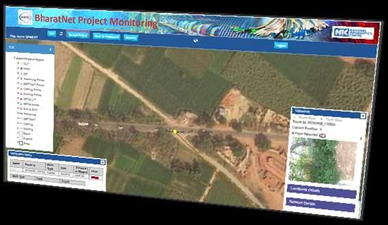


23 BHARATNET PROJECT MONITORING National Informatics Centre 23
24 Objective School Location Mapping (School GIS Version 1.0) Web Based School GIS application is an initiative of the Department of School Education and Literacy, Ministry of Human Resources Department, Government of India for seamless visualization of school locations across the country. Geographic location of schools collected by the various School Education Departments of the states has been collated and mapped on GIS Platform established by National Informatics Centre. The objectives of the School Location Mapping GIS application is to help improve the quality of planning and to better the utilization of resources available under the Sarva Shiksha Abhiyan (SSA) and Rashtriya Madhyamik Shiksha Abhiyan (RMSA) Salient features A robust spatial representation of data Incorporates a map view that allows for visualization of Schools based on their location and also allows for analysis of said data. GIS Tools - Standard GIS functions, Identify, Navigation, Search, Buffer and Distance Measurement. Thematic Mapping of Schools based on the various categories of Schools that are located on the Map, so as to provide a comprehensive representation of the spread of schools in any given area. Spatial Data (Layers) National/State/District/Block Village Location Data Received Status (To identify the status of School Mapping in each State) School Location KVS School Location National Informatics Centre Functionalities Map Viewer with GIS Navigation Tools (Zoom In, Zoom Out, Pan and Full Extent) Identify Table of Content Measure Base map Gallery Area of Interest Thematic Mapping of Schools Based on Categories Category Based Buffer Proximity Buffer Graphical Selection of Schools Schools Search by Locators (By School Name, School Code and Village Name) 24


")

25 School Location Mapping (School GIS Version 1.0) National Informatics Centre 25
26 Geo-Enabling E-governance - Probable List of GIS DSS Application Plan-GIS for Planning Commission supporting the planning, monitoring and reviewing plans and development. GIS for Public services as part of PIII services in various areas Rural-GIS for various rural development programmes of the Ministry of Rural Development. City-GIS service to planning, management and development of ~5200 urban areas for Ministry of Urban Development. Roads Monitoring service for PMGSY as well as a Roads-GIS for NHAI/Ministry of Surface Transport Health-GIS service as part of support to the Ministry of Health & Family Welfare Water Resources-GIS for water resources management of Ministry of Water Resources Agri-GIS service for the Agriculture and Farm sector through Ministry of Agriculture GIS for Disaster Management Support for supporting management of disaster for NDMA GIS for Infrastructure sector be they in roads and highways, rail systems, airport infrastructure or other social infrastructure. Env-GIS for Environment and Climate Change monitoring of Ministry of Environment and Forests GIS for Aadhar integrated with UID Census-GIS for Registrar General of India Weather-GIS and ES-GIS for IMD/MoES. GIS for Security as a support for the security programmes of Ministry of Home Affairs. NE-GIS for meeting the GIS data and DSS needs of MONER Coal & Mines -GIS for Ministry of Coal & Mines for supporting mining activities Heavy Industry-GIS for Department of Heavy Industries New Energy-GIS for Ministry of New and Non-Renewable Energy Tourism-GIS for supporting Ministry of Tourism Panchayat-GIS in support of Ministry of Panchayati Raj Stat-GIS for the Ministry of Statistics and Programme Implementation Power-GIS in support of Ministry of Power Steel-GIS in support of Ministry of Steel and its mining PSUs GIS data access applications for use for Defence GIS requirements. Provide for private sector GIS applications to be hosted and published on the National GIS. Crowd-Sourcing- Citizen access to National GIS would be enabled through simple GIS Applications and integrated e-services.
27 Utility Mapping Services Smart Cities Digital Basemap of the Scale of 1:1000 of Seven Metro cities is available online in G2G mode. Digital Basemap is located in NDCSP and can be accessed through secured connection. Cities Departments are using these maps for mapping and managing their assets The cities are: Ahmedabad, Bengaluru, Chennai, Delhi, Hyderabad, Kolkata, Mumbai
28 Slum Rehabilitation Authority, Mumbai Slum Rehabilitation Authority (SRA) is accessing the Mumbai Digital Basemap and mapping their Slum boundaries with the accuracy of 6 cm. GIS cell in SRA premises to analyze and updating of the data. Slum boundaries are surveyed using latest technology like GPS Slums are also surveyed using Lidar and get the accurate 3D map which will superimpose on the Mumbai Basemap. SRA complete 70% of the GIS work in just 3 months using Mumbai Basemap. This will give a complete and accurate prime land detail to SRA to plan for making it commercial and residential purposes.


29 Details of an Details individual of an individual property

30 Land Parcel Information System


31 Address Tool Address System 40, Mayurdhwaj Aptt, 92

32 3-D map Ahmedabad Mumbai Hyderabad Bangaluru Kolkata Chennai Delhi

33 Punjab GIS An Example of Collaborative Mapping
34 Punjab Roads

35

36

37

38

39

40

41

42

43 Web Editor for Roads and Mandi Locations

44 Web Editor for Roads with Imagery..

45 Marketing Committee Boundaries

46 Marketing Committee Boundaries
47 Conclusion GIS Enabling ( Digital ) Transformation means end to end service delivery covering work-flows, business activities, processes, competencies and models to fully leverage changes in planning & decision making so that benefits & positive impact and opportunities gets created at all levels of society. GIS enabling Embedded as Core to Transformation. Digital Technology Solutions (viz. Big Data, Location Intelligence, IOT, Sensor Enablement etc. with GIS as part of end to end service delivery platform)


48
National GIS Platform for Digital India. Dr.(Mrs.) Vandana Sharma Deputy Director General National Informatics Centre
 Vandana Sharma Deputy Director General National Informatics Centre") National GIS Platform for Digital India Dr.(Mrs.) Vandana Sharma Deputy Director General National Informatics Centre sharma.vandana@nic.in NIC DEITY - National e-governance Infrastructure Meghraj Cloud
National GIS Platform for Digital India Dr.(Mrs.) Vandana Sharma Deputy Director General National Informatics Centre sharma.vandana@nic.in NIC DEITY - National e-governance Infrastructure Meghraj Cloud
Working with ArcGIS Online
 Esri International User Conference San Diego, CA Technical Workshops July 12, 2011 Working with ArcGIS Online Bern Szukalski, Deane Kensok Topics for this Session ArcGIS Online Overview ArcGIS Online Content
Data Aggregation with InfraWorks and ArcGIS for Visualization, Analysis, and Planning
 Data Aggregation with InfraWorks and ArcGIS for Visualization, Analysis, and Planning Stephen Brockwell President, Brockwell IT Consulting, Inc. Join the conversation #AU2017 KEYWORD Class Summary Silos
A Broad View of Geospatial Technology & Systems
 A Broad View of Geospatial Technology & Systems Pete Large Vice President, Trimble On the shoulders of giants 1 Since their time, our ability to generate geospatial information has grown exponentially
Geospatial SDI Portal for effective Governance of Pune METROPOLIS region
 Geospatial SDI Portal for effective Governance of Pune METROPOLIS region Mr. Praveen Gautam Senior Manager 19 th January 2018 PMRDA Overview Provide a Spatial Framework for the entire region with various
Esri and GIS Education
 Esri and GIS Education Organizations Esri Users 1,200 National Government Agencies 11,500 States & Regional Agencies 30,800 Cities & Local Governments 32,000 Businesses 8,500 Utilities 12,600 NGOs 11,000
Geography for the 2020 Round of Census
 Boundaries Key Census Data EA Id Population Male Female EA Id Area EA Id Num HH Avg HH size Geography for the 2020 Round of Census Linda Peters, Esri lpeters@esri.com Integration of Statistical and Geospatial
CAPE FARM MAPPER - an integrated spatial portal
 CAPE FARM MAPPER - an integrated spatial portal Skukuza Dr Mike Wallace June 2017 Overview of GIS applications in WCDoA Spatial information and technology has become indispensable across a wide range of
Oman NSDI Supporting Economic Development. Saud Al-Nofli Director of Spatial Data Directorate General of NSDI, NCSI
 Oman NSDI Supporting Economic Development 2017 Saud Al-Nofli Director of Spatial Data Directorate General of NSDI, NCSI "It s critical to make correct decisions the first time to optimize the Investments
Gov 2.0. Encourage citizen engagement, deliver transparency, and foster collaboration with ArcGIS.
 Gov 2.0 Encourage citizen engagement, deliver transparency, and foster collaboration with ArcGIS. F E D E R A L GIS A Platform for Open Government Upon taking office, President Barack Obama issued an open
for Effective Land Administration
 Role of Geospatial Technology in Land Information System(LIS) for Effective Land Administration Dr. Deb Jyoti Pal Sections Role of GIS in Land Records Proposed Work Flow Case Studies Role of GIS Creating
Leveraging Web GIS: An Introduction to the ArcGIS portal
 Leveraging Web GIS: An Introduction to the ArcGIS portal Derek Law Product Management DLaw@esri.com Agenda Web GIS pattern Product overview Installation and deployment Configuration options Security options
Karnataka GIS. Preview of K-GIS Components, Status, Policies, Opportunities, Challenges and Vision M.JAYACHANDRAN. KGIS - Mission Management
 Karnataka GIS Preview of K-GIS Components, Status, Policies, Opportunities, Challenges and Vision BY M.JAYACHANDRAN KGIS - Mission Management Karnataka State Remote Sensing Applications Center, GoK 18-Jan-2018
ArcGIS is Advancing. Both Contributing and Integrating many new Innovations. IoT. Smart Mapping. Smart Devices Advanced Analytics
 ArcGIS is Advancing IoT Smart Devices Advanced Analytics Smart Mapping Real-Time Faster Computing Web Services Crowdsourcing Sensor Networks Both Contributing and Integrating many new Innovations ArcGIS
About the Presenter. Dr. Nassim Al-Abed. Transport
 1. معلومات أساسية عن الداي رة Abu Dhabi Department of Transport Enterprise GIS Application GeoTRANS Presented by: Dr. Nassim Al-AbedAbed GIS Section March 28, 2011 24th Annual GIS-T Symposium Hershey,
June 19 Huntsville, Alabama 1
 June 19 Huntsville, Alabama 1 Real-Time Geospatial Data: The Fusion of PI and ArcGIS Enabling Smarter Facilities Management OSIsoft and Esri Mapping and Location Analytics Platform Supporting Your Use
SOLUTIONS ADVANCED GIS. TekMindz are developing innovative solutions that integrate geographic information with niche business applications.
 ADVANCED GIS SOLUTIONS TekMindz are developing innovative solutions that integrate geographic information with niche business applications. TEK INDZ TM GIS Services Overview At the leading edge of geospatial
SCAUG Community Maps Building a Living Atlas of the World
 SCAUG Community Maps Building a Living Atlas of the World Mark Stewart Topics: SCAUG ArcGIS Online Overview Community Maps Overview Community Maps Workflow Update Process Utilizing Your Contribution Community
TRAITS to put you on the map
 TRAITS to put you on the map Know what s where See the big picture Connect the dots Get it right Use where to say WOW Look around Spread the word Make it yours Finding your way Location is associated with
CLICK HERE TO KNOW MORE
 CLICK HERE TO KNOW MORE GeoSpace for Singapore s Whole-of-Government Data Sharing Asia GeoSpatial Forum 17 19 Oct 2011 Lee Kim Haw Singapore Land Authority Introducing Singapore Land Authority Limited
Better Topographic Map Production Using ArcGIS. A Comprehensive Solution for Mapping Organizations
 Better Topographic Map Production Using ArcGIS A Comprehensive Solution for Mapping Organizations The World Is Always Changing As a member of a national mapping organization, you know this is true. You
2 nd Semester. Core Courses. C 2.1 City and Metropolitan Planning. Module 1: Urban Structure and Growth Implications
 2 nd Semester Core Courses C 2.1 City and Metropolitan Planning Module 1: Urban Structure and Growth Implications Growth of cities; cities as engine of growth; urban sprawl; land value, economic attributes
Oman NSDI Business Values and Future Directions. Hassan Alawi Alghazali Acting Director General National Spatial Data Infrastructure
 Oman NSDI Business Values and Future Directions Hassan Alawi Alghazali Acting Director General National Spatial Data Infrastructure Presentation Outline Geospatial Maturity Current Challenges NCSI s Role
OFWIM 2017 Annual Conference What Does Web GIS Really Mean for Fish and Wildlife Agencies?
 Content Open Mapping OFWIM 2017 Annual Conference What Does Web GIS Really Mean for Fish and Wildlife Agencies? Imagery Spatial Analysis Mike Bialousz, Esri 3D Data Exploration Real-Time Apps Visualization
The Pace of Change Is Accelerating Creating Many Challenges
 VISION The Pace of Change Is Accelerating Creating Many Challenges Evidence Threatening Our Natural World and Our Future as Humans Social Conflict Mass Migration Ocean Acidification Food Population Urbanization
DATA APPLIANCE FOR ARCGIS
 DATA APPLIANCE FOR ARCGIS Data Appliance for ArcGIS Provides Access to Multi-Scale Basemaps Down to Medium Scale Levels Worldwide And Large Scale for Most of the World The Data Appliance includes Several
Portal for ArcGIS: An Introduction. Catherine Hynes and Derek Law
 Portal for ArcGIS: An Introduction Catherine Hynes and Derek Law Agenda Web GIS pattern Product overview Installation and deployment Configuration options Security options and groups Portal for ArcGIS
Spatial Data Availability Energizes Florida s Citizens
 NASCIO 2016 Recognition Awards Nomination Spatial Data Availability Energizes Florida s Citizens State of Florida Agency for State Technology & Department of Environmental Protection Category: ICT Innovations
Key Points Sharing fosters participation and collaboration Metadata has a big role in sharing Sharing is not always easy
 Sharing Resources Geoff Mortson esri, Inc. SDI Solutions Team Key Points Sharing fosters participation and collaboration Metadata has a big role in sharing Sharing is not always easy Data Sharing is Good
Economic Benefit Study on Value of Spatial Information Australian Experience
 Economic Benefit Study on Value of Spatial Information Australian Experience Dr Zaffar Sadiq Mohamed-Ghouse Director, International Relations Cooperative Research Centre for Spatial Information zsadiq@crcsi.com.au
Climate Risk Visualization for Adaptation Planning and Emergency Response
 Climate Risk Visualization for Adaptation Planning and Emergency Response NCR Flood Fact Finding Workshop Ricardo Saavedra ricardo@vizonomy.com Social Media, Mobile, and Big Data St. Peter s Basilica,
Voices from Private Sector: Insights for Future NSDI Development in Indonesia
 Voices from Private Sector: Insights for Future NSDI Development in Indonesia Ta n d a n g Yu l i a d i D w i P u t ra, Ryosuke S h i b a s a k i I n st i t u t e o f I n d u st r i a l S c i e n c e,
INDONESIA S S UPDATE: GEOSPATIAL INFORMATION FOR SUSTAINABLE DEVELOPMENT RELATED TO INA SDI Dr. Asep Karsidi, M.Sc
 INDONESIA S S UPDATE: GEOSPATIAL INFORMATION FOR SUSTAINABLE DEVELOPMENT RELATED TO INA SDI Dr. Asep Karsidi, M.Sc GEOSPATIAL INFORMATION AGENCY 08 August, 2012 OUTLINE 1. Transformation Bakosurtanal into
Evaluating e-government : implementing GIS services in Municipality
 Evaluating e-government : implementing GIS services in Municipality Municipality of Thessaloniki - G.I.S. Unit Misirloglou Symeon Head of the GIS Unit ESRI UC - 2016 The GIS Section - subset of the department
Corporate. Information. Railway Infrastructure Administrator. Year indracompany.com
 geospatial and mobility Corporate Geographic Information System of ADIF Railway Infrastructure Administrator. Year 2009-2010 Corporate Geographic Information System of ADIF ADIF. Spanish Administrator
HISTORY OF GIS AND ESRI
 HISTORY OF GIS AND ESRI First Developed by Dr. Roger Tomlinson in Canada 1960 (CGIS Canadian geographic system) The system was designed to inventory land use and assist in the management of natural resources
Discovery and Access of Geospatial Resources using the Geoportal Extension. Marten Hogeweg Geoportal Extension Product Manager
 Discovery and Access of Geospatial Resources using the Geoportal Extension Marten Hogeweg Geoportal Extension Product Manager DISCOVERY AND ACCESS USING THE GEOPORTAL EXTENSION Geospatial Data Is Very
Getting Started with Community Maps
 Esri International User Conference San Diego, California Technical Workshops July 24, 2012 Getting Started with Community Maps Shane Matthews and Tamara Yoder Topics for this Session ArcGIS is a complete
OC Enterprise GIS. Kevin Hills, PLS Cameron Smith, GISP. OC Survey
 OC Enterprise GIS Kevin Hills, PLS Cameron Smith, GISP OC Survey Discussion Points Background & Organizational Structure of OCPW Past practices prior to Enterprise Wide GIS License (ELA) Participating
Esri s Living Atlas of the World Community Maps
 Esri s Living Atlas of the World Community Maps Seth Sarakaitis Wednesday May 7, 2014 ArcGIS Living Atlas Concept Living Atlas Content Tour Contributing to the Living Atlas (Community Maps) Seth Sarakaitis
2-4 April 2019 Taets Art and Event Park, Amsterdam CLICK TO KNOW MORE
 Co-Host Host 2-4 April 2019 Taets Art and Event Park, Amsterdam CLICK TO KNOW MORE Delhi Jal Board, INDIA Improving Revenue Management for Urban Water Supply through Spatially Enabled Systems: Applied
Excel Geomatics: Offering Excellence with Unique Consultancy & Services
 Excel Geomatics: Offering Excellence with Unique Consultancy & Services Providing consultancy and value Added Services using Remote Sensing, Photogrammetry and LiDAR in areas such as Agriculture, Forestry,
You are Building Your Organization s Geographic Knowledge
 You are Building Your Organization s Geographic Knowledge And Increasingly Making it Available Sharing Data Publishing Maps and Geo-Apps Developing Collaborative Approaches Citizens Knowledge Workers Analysts
ESRI Delivering geographic information systems to millions of users
 Using Web GIS to Track Government Spending and Performance Eric Floss - ESRI April 12, 2010 ESRI Delivering geographic information systems to millions of users GIS Is Changing Everything How We Reason
Geo-Enabling Mountain Bike Trail Maintenance:
 Title Slide Geo-Enabling Mountain Bike Trail Maintenance: Enhanced Stewardship of the Fountainhead Mountain Bike Trail through GIS Technology Ruthann Ligon Follow the Trail Fountainhead Mountain Bike
Web GIS: Architectural Patterns and Practices. Shannon Kalisky Philip Heede
 Web GIS: Architectural Patterns and Practices Shannon Kalisky Philip Heede Web GIS Transformation of the ArcGIS Platform Desktop Apps Server GIS Web Maps Web Scenes Layers Web GIS Transformation of the
WELCOME & INTRODUCTIONS
 GIS Monroe Geographic Information System January 31, 2018 WELCOME & INTRODUCTIONS Chip Thomas, Ritter GIS Sarah Schrader, Acct. Mgr., ESRI Chris Beyett, Solutions Engineer, ESRI Colleen Hinzmann, IT Director,
Web GIS Deployment for Administrators. Vanessa Ramirez Solution Engineer, Natural Resources, Esri
 Web GIS Deployment for Administrators Vanessa Ramirez Solution Engineer, Natural Resources, Esri Agenda Web GIS Concepts Web GIS Deployment Patterns Components of an On-Premises Web GIS Federation of Server
Imagery and the Location-enabled Platform in State and Local Government
 Imagery and the Location-enabled Platform in State and Local Government Fred Limp, Director, CAST Jim Farley, Vice President, Leica Geosystems Oracle Spatial Users Group Denver, March 10, 2005 TM TM Discussion
The Emerging Role of Enterprise GIS in State Forest Agencies
 The Emerging Role of Enterprise GIS in State Forest Agencies Geographic Information System (GIS) A geographic information system (GIS) is a computer software system designed to capture, store, manipulate,
The Integrated Ge spatial Information Framework to the strengthening of NSDI, Mongolia
 Young Geospatial Professionals Summit 21 NOV 2018 The Integrated Ge spatial Information Framework to the strengthening of NSDI, Mongolia BAYARMAA ENKHTUR Geospatial information and technology department
ESTABLISHMENT OF KARNATAKA GEOPORTAL AND ITS ROLE IN PLANNING
 ESTABLISHMENT OF KARNATAKA GEOPORTAL AND ITS ROLE IN PLANNING By H. Hemanth Kumar Karnataka State Council for Science & Technology (KSCST), Indian Institute of Science, Bangalore, India Abstract Natural
Welcome. C o n n e c t i n g
 Welcome C o n n e c t i n g YOU D i s c i p l i n e s Why is This Meeting......So Important Now? OUR WORLD Is Increasingly Challenged The Evidence Is Clear We Need Better Understanding and More Collaboration
Spatial Analysis with Web GIS. Rachel Weeden
 Spatial Analysis with Web GIS Rachel Weeden Agenda Subhead goes here Introducing ArcGIS Online Spatial Analysis Workflows Scenarios Other Options Resources ArcGIS is a Platform Making mapping and analytics
Demystifying ArcGIS Online. Karen Lizcano Esri
 Demystifying ArcGIS Online Karen Lizcano Esri An Integrated Web GIS Platform Desktop Web Device Powered by Services Managed via Portal Access from any Device Portal Server Online Content and Services ArcGIS
Open spatial data infrastructure
 Open spatial data infrastructure a backbone for digital government Thorben Hansen Geomatikkdagene 2018 Stavanger 13.-15. mars Spatial Data Infrastructure definition the technology, policies, standards,
GIS Monroe Geographic Information System March 14, 2018
 GIS Monroe Geographic Information System March 14, 2018 Goals Maintain Enterprise/County-wide geo-database Increase spatial accuracy of data Build and acquire more data layers Increase use of GIS; as another
IMPLEMENTING GOVERNMENT-WIDE ENTERPRISE GIS; THE FEDERATED MODEL
 IMPLEMENTING GOVERNMENT-WIDE ENTERPRISE GIS; THE FEDERATED MODEL James E. Mitchell, Ph. D. IT GIS Manager Louisiana Department of Transportation and Development presented at the ESRI International Users
Spatially Enabled Society
 International Seminar on Land Administration Trends and Issues in Asia and the Pacific Region Spatially Enabled Society Abbas Rajabifard Vice Chair PCGIAP-WG3 Vice-President (President Elect), GSDI Association
European Location Framework data in the ArcGIS platform
 European Location Framework data in the ArcGIS platform Presentation to: Author: Date: INSPIRE Conference 2016 Clemens Portele 26 September 2016 Why ELF? Global (e.g. UN GGIM) Regional Europe (INSPIRE
Tools to Assess Local Health Needs. Richard Leadbeater, Esri NACo 2011 Healthy Counties Forum December 1, 2011
 Tools to Assess Local Health Needs Richard Leadbeater, Esri NACo 2011 Healthy Counties Forum December 1, 2011 Richard Leadbeater currently holds the position of Industry Solutions Manager with Esri. He
ArcGIS for INSPIRE. Marten Hogeweg Satish Sankaran
 ArcGIS for INSPIRE Marten Hogeweg Satish Sankaran Outline What is ArcGIS ArcGIS for INSPIRE Web GIS Case Studies Roadmap Q&A What is INSPIRE? INSPIRE is the legal framework for a European Spatial Data
Open Cities Project. The World Bank, South Asia Region. Background
 Open Cities Project The World Bank, South Asia Region Opencitiesproject.com Background The World Bank s South Asia Region (SAR) is proud to announce its new Open Cities Project. The goal of this project
SUPPORTS SUSTAINABLE GROWTH
 DDSS BBUUN NDDLLEE G E O S P AT I A L G O V E R N A N C E P A C K A G E SUPPORTS SUSTAINABLE GROWTH www.digitalglobe.com BRISBANE, AUSTRALIA WORLDVIEW-3 30 CM International Civil Government Programs US
Creating a Staff Development Plan with Esri
 Creating a Staff Development Plan with Esri Michael Green David Schneider Guest Presenter: Shane Feirer, University of California Esri UC 2014 Technical Workshop Agenda What is a Staff Development Plan?
Innovation. The Push and Pull at ESRI. September Kevin Daugherty Cadastral/Land Records Industry Solutions Manager
 Innovation The Push and Pull at ESRI September 2004 Kevin Daugherty Cadastral/Land Records Industry Solutions Manager The Push and The Pull The Push is the information technology that drives research and
CENSUS MAPPING WITH GIS IN NAMIBIA. BY Mrs. Ottilie Mwazi Central Bureau of Statistics Tel: October 2007
 CENSUS MAPPING WITH GIS IN NAMIBIA BY Mrs. Ottilie Mwazi Central Bureau of Statistics E-mail: omwazi@npc.gov.na Tel: + 264 61 283 4060 October 2007 Content of Presentation HISTORICAL BACKGROUND OF CENSUS
GIS and Governing Anchorage. GIS Critical for Efficient, Transparent Government How is GIS Program Doing Where can GIS Program Take us
 GIS and Governing Anchorage GIS Critical for Efficient, Transparent Government How is GIS Program Doing Where can GIS Program Take us Municipality of Anchorage Office of Economic And Community Development
Presented to Sub-regional workshop on integration of administrative data, big data and geospatial information for the compilation of SDG indicators
 Presented to Sub-regional workshop on integration of administrative data, big data and geospatial information for the compilation of SDG indicators 23-25 April,2018 Addis Ababa, Ethiopia By: Deogratius
ArcGIS. for Server. Understanding our World
 ArcGIS for Server Understanding our World ArcGIS for Server Create, Distribute, and Manage GIS Services You can use ArcGIS for Server to create services from your mapping and geographic information system
Colin Bray, OSi CEO. Collaboration to develop a data platform for geospatial and statistical information in Ireland
 Colin Bray, OSi CEO Collaboration to develop a data platform for geospatial and statistical information in Ireland Organisations Ireland s National Mapping Agency Established in 1824 Operates under the
US National Spatial Data Infrastructure A Spatial Framework for Governance and Policy Development to Enable a Location-Based Digital Ecosystem
 GeoPlatform Workshop 7 Dec 2016, Department of the Interior Washington, D.C. US National Spatial Infrastructure A Spatial Framework for Governance and Policy Development to Enable a Location-Based Digital
GIS for the Beginner on a Budget
 GIS for the Beginner on a Budget Andre C. Bally, RLA, GIS Coordinator, Harris County Public Infrastructure Department Engineering Division This presentation, GIS for Beginners on a Budget. will briefly
GeoSUR SRTM 30-m / TPS
 GeoSUR SRTM 30-m / TPS Wm Matthew Cushing (USGS) 16 May 2013 U.S. Department of the Interior U.S. Geological Survey SRTM Mission Shuttle Radar Topography Mission (SRTM) Space Shuttle Endeavour during the
Regione Umbria. ESRI EMEA User Conference 2010 Rome, October 27th 2010
 Direzione Ambiente, Territorio e Infrastrutture Servizio Informatico/Informativo: geografico, ambientale e territoriale ESRI EMEA User Conference 2010 Rome, October 27th 2010 Arch. Ambra Ciarapica, Dott.
Copernicus Overview. Major Emergency Management Conference Athlone 2017
 Copernicus Overview Major Emergency Management Conference Athlone 2017 Copernicus is a European programme implemented by the European Commission. The services address six thematic areas: land, marine,
Realizing benefits of Spatial Data Infrastructure A user s perspective from Environment Agency - Abu Dhabi
 Realizing benefits of Spatial Data Infrastructure A user s perspective from Environment Agency - Abu Dhabi Anil Kumar Director, Environment Information Management 26 April 2012 Geospatial World Forum,
Introduction to Portal for ArcGIS
 Introduction to Portal for ArcGIS Derek Law Product Management March 10 th, 2015 Esri Developer Summit 2015 Agenda Web GIS pattern Product overview Installation and deployment Security and groups Configuration
NOACA s DART: Web GIS Tools for Transportation Planning. Chad Harris, NOACA Bryan Baker, Tierra Plan LLC Kevin Knapp, Tierra Plan LLC
 NOACA s DART: Web GIS Tools for Transportation Planning Chad Harris, NOACA Bryan Baker, Tierra Plan LLC Kevin Knapp, Tierra Plan LLC NOACA DART: Data Analysis and Reporting Tool NOACA: Northeast Ohio Areawide
EMMA : ECDC Mapping and Multilayer Analysis A GIS enterprise solution to EU agency. Sharing experience and learning from the others
 EMMA : ECDC Mapping and Multilayer Analysis A GIS enterprise solution to EU agency. Sharing experience and learning from the others Lorenzo De Simone, GIS Expert/ EMMA Project Manager 2014 GIS Workshop,
Web GIS Patterns and Practices
 FedGIS Conference February 24 25, 2016 Washington, DC Web GIS Patterns and Practices Philip Heede Jay Theodore Witt Mathot Web GIS Transformation of the ArcGIS Platform Desktop Apps Web Maps Web Scenes
HIGH RESOLUTION BASE MAP: A CASE STUDY OF JNTUH-HYDERABAD CAMPUS
 HIGH RESOLUTION BASE MAP: A CASE STUDY OF JNTUH-HYDERABAD CAMPUS K.Manjula Vani, Abhinay Reddy, J. Venkatesh, Ballu Harish and R.S. Dwivedi ABSTRACT The proposed work High Resolution Base map: A Case study
Georeferencing and Satellite Image Support: Lessons learned, Challenges and Opportunities
 Georeferencing and Satellite Image Support: Lessons learned, Challenges and Opportunities Shirish Ravan shirish.ravan@unoosa.org UN-SPIDER United Nations Office for Outer Space Affairs (UNOOSA) UN-SPIDER
Module - 3 GIS MAPPING, MIS AND GIS UNDER RAY
 Module - 3 1 GIS MAPPING, MIS AND GIS MIS INTEGRATION UNDER RAY Role of GIS & MIS under RAY Under the scheme, two step implementation strategy has been adopted i.e. preparation of SFCPoAs on whole city
ENV208/ENV508 Applied GIS. Week 1: What is GIS?
 ENV208/ENV508 Applied GIS Week 1: What is GIS? 1 WHAT IS GIS? A GIS integrates hardware, software, and data for capturing, managing, analyzing, and displaying all forms of geographically referenced information.
GEOGRAPHIC INFORMATION SYSTEMS Session 8
 GEOGRAPHIC INFORMATION SYSTEMS Session 8 Introduction Geography underpins all activities associated with a census Census geography is essential to plan and manage fieldwork as well as to report results
Portal for ArcGIS: An Introduction
 Portal for ArcGIS: An Introduction Derek Law Esri Product Management Esri UC 2014 Technical Workshop Agenda Web GIS pattern Product overview Installation and deployment Security and groups Configuration
Introduction to GIS. Dr. M.S. Ganesh Prasad
 Introduction to GIS Dr. M.S. Ganesh Prasad Department of Civil Engineering The National Institute of Engineering, MYSORE ganeshprasad.nie@gmail.com 9449153758 Geographic Information System (GIS) Information
Changes in Esri GIS, practical ways to be ready for the future
 Changes in Esri GIS, practical ways to be ready for the future John Sharrard, Esri April 16, 2015 The only thing that is constant is change. Heraclitus, ca. 500 B.C. My story (of experiencing change) Changes
Local Government. VALOR GIS Specialist South Georgia RDC
 Lw Low Cost GIS Sl Solutions for Local Government By: Joe Bendis VALOR GIS Specialist South Georgia RDC SERUG 2008 GIS success through cooperation $ $ VALOR Today: 5 staff members dedicated to VALOR innovations,
ArcGIS for INSPIRE. Marten Hogeweg
 ArcGIS for INSPIRE Marten Hogeweg Please Take Our Survey on the App Download the Esri Events app and find your event Select the session you attended Scroll down to find the feedback section Complete answers
Introduction to Portal for ArcGIS. Hao LEE November 12, 2015
 Introduction to Portal for ArcGIS Hao LEE November 12, 2015 Agenda Web GIS pattern Product overview Installation and deployment Security and groups Configuration options Portal for ArcGIS + ArcGIS for
Sustainability Adaptation Transparency Accountability. $400 FBC of fuel.
 Sustainability Adaptation Transparency Accountability $400 FBC of fuel. We need a sustainability platform Tools for organization, collaboration, policy, data collection, storage, analysis, understanding,
Features and Benefits
 Autodesk LandXplorer Features and Benefits Use the Autodesk LandXplorer software family to help improve decision making, lower costs, view and share changes, and avoid the expense of creating physical
Adding value to Copernicus services with member states reference data
 www.eurogeographics.org Adding value to Copernicus services with member states reference data Neil Sutherland neil.sutherland@os.uk GIS in the EU 10 November 2016 Copyright 2016 EuroGeographics 61 member
CLAREMONT MASTER PLAN 2017: LAND USE COMMUNITY INPUT
 Planning and Development Department 14 North Street Claremont, New Hampshire 03743 Ph: (603) 542-7008 Fax: (603) 542-7033 Email: cityplanner@claremontnh.com www.claremontnh.com CLAREMONT MASTER PLAN 2017:
Arctic Spatial Data Infrastructure Enabling Access to Arctic Location-Based Information
 Arctic Spatial Data Infrastructure Enabling Access to Arctic Location-Based Information Arctic SDI Side Event Co-Chairs: Arvo Kokkonen Arctic SDI Board Chair & Director General, National Land Survey of
XXIII CONGRESS OF ISPRS RESOLUTIONS
 XXIII CONGRESS OF ISPRS RESOLUTIONS General Resolutions Resolution 0: Thanks to the Czech Society commends: To congratulate The Czech Society, its president and the Congress Director Lena Halounová, the
Preparation of Database for Urban Development
 Preparation of Database for Urban Development By PunyaP OLI, 1. Chairman, ERMC (P) Ltd., Kathmandu, Nepal. Email: punyaoli@ermcnepal.com 2. Coordinator, Himalayan College of Geomatic Engineering and Land
DP Project Development Pvt. Ltd.
 Dear Sir/Madam, Greetings!!! Thanks for contacting DP Project Development for your training requirement. DP Project Development is leading professional training provider in GIS technologies and GIS application