Ocean Teacher Global Academy (OTGA) Training Course on GIS Applications for Coastal Zone Management 28 August - 01 September, 2017
|
|
|
- Hillary King
- 5 years ago
- Views:
Transcription


1 Ocean Teacher Global Academy (OTGA) Training Course on GIS Applications for Coastal Zone Management 28 August - 01 September, 2017 N. Kiran Kumar Scientist-D & In-charge Web Based Services, INCOIS kirankumar@incois.gov.in International Training Centre for Operational Oceanography (ITCOocean) ESSO-INCOIS, Hyderabad, India International Oceanographic Data and Information Exchange
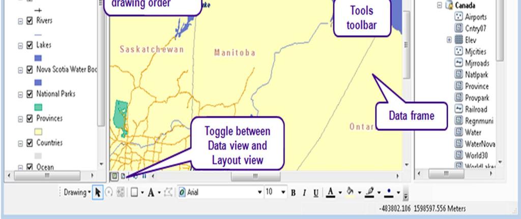
2 Overview GIS Basic Components Geographic Data Models & How data is used in ArcGIS GIS Types & available GIS Software s Components of ERDAS, ArcGIS ArcMap, ArcCatalog and ArcToolbox GIS on the Web ArcGIS Server, ArcGIS Online, Google Earth Extensions of ArcGIS Spatial Analyst, Geostatistical Analyst and 3D Analyst


3 A GIS integrates five basic components Methods Hardware Data People

4 GIS and maps What do you use maps for? What do you use GIS maps for?


5 Maps and layers A GIS uses layers to characterize and describe our world
6 Describing our World We can describe any element of our world in two ways: Spatial Information: Where is it? Attribute Information: What is it? Species: Oak Height: 15m Age: 75 Yrs 51 N, 112 W
7 Geographic Data Models All geographic information systems are built using formal models that describe how things are located in space. A formal model is an abstract and well-defined system of concepts. A geographic data model defines the vocabulary for describing and reasoning about the things that are located on the earth. Geographic data models serve as the foundation on which all geographic information systems are built. Scott Morehouse, Preface to Modeling our World
8 Data Models A geographic data model is a structure for organizing geospatial data so that it can be easily stored and retrieved. Geographic coordinates Tabular attributes
9 File-based Data Models Arc Geographic coordinates and attributes are stored in separate but linked files Info Coverages Developed for workstation Arc/Info ~ 1980 Complex structure, proprietary format Attributes in Info tables Shapefiles Developed for ArcView ~ 1993 Simpler structure in public domain Attributes in dbase (.dbf) tables
10 Storing Data Coverages Shapefiles Texas Texas Counties Evap Info Counties.shp Counties.shx Counties.dbf Evap.shp Evap.shx Evap.dbf
11 Storing Data Coverages and Shapefiles Coverages are stored partially in their own folder (ARC) and partially in the common INFO folder. Shapefiles are stored in three to five files (with extensions.shp,.shx,.dbf,.sbx and.sbn). Coverages store common boundaries between polygons only once, to avoid redundancy. Shapefiles store all the geometry of each polygon regardless of redundancy. Coverage features are single lines or single polygons. Shapefiles allow features to have multiple, disconnected, intersecting and overlapping components.

12 Geodatabase and Feature Dataset A geodatabase is a relational database that stores geographic information. A feature dataset is a collection of feature classes that share the same spatial reference frame.
13 Geodatabase model Stores geographic coordinates as one attribute (shape) in a relational database table Uses MS Access for Personal Geodatabase (single user) Shape Uses Oracle, SQL/Server, DB2 or other commercial relational databases for Enterprise Geodatabases (many simultaneous users) Uses files in File Geodatabase


14 Geodatabase Workspace Geodatabase Feature Dataset Feature Class Geometric Network Relationship Object Class

15 Object Class An object class is a collection of objects in tabular format that have the same behavior and the same attributes. An object class is a table that has a unique identifier (ObjectID) for each record


16 Feature Class A feature class is a collection of geographic objects in tabular format that have the same behavior and the same attributes. Feature Class = Object class + spatial coordinates
17 Relationship A relationship is an association or link between two objects in a database. A relationship can exist between spatial objects (features in feature classes), non-spatial objects (objects in object classes), or between spatial and non-spatial objects.

18 Relationship Relationship between non-spatial objects Water Quality Data Water Quality Parameters

 Measurement")
19 Relationship Relationship between spatial and non-spatial objects Water quality data (non-spatial) Measurement station (spatial)
20 Network A network is a set of edges (lines) and junctions (points) that are topologically connected to each other. Each edge knows which junctions are at its endpoints Each junction knows which edges it connects to
21 What types of geographic data do you work with?


22 Vector model Geographic features are most commonly represented as points lines polygons Retail stores Streets Parcels Points Lines Areas/Polygons


23 Vector data organization Stored as feature classes Same geometry Same attributes Attributes for points Points Lines Polygons Shape field: Stores feature class geometry

24 Raster data model Used to represent imagery digital elevation models other thematic data

25 Raster data organization Matrix of cells Cell values measurements counts statistical values codes (4,5)


26 GIS Creating Our Future
27 GIS Types and Available GIS Software's Management and analysis - GIS statistical software uses standard database queries to retrieve data and analyze data for decision making. Web Application Programming Interface (API) is a set of subroutines designed to manage GIS data for its delivery to a web browser client from a GIS server using scripting language such as VBA or JavaScript. Distributed GIS are web-based GIS, Mobile GIS, Corporate GIS and GRID computing. Mobile GIS - implementations on mobile devices. With the widespread adoption of GPS, GIS has been used to capture and integrate data in the field.
28 Open-source GIS Software freely available over Internet downloads. They adopt OGC standards for networked servers, development of open source software continues to evolve, especially for web and web service oriented applications. Well-known open source GIS software includes GRASS GIS, Quantum GIS, MapServer, udig, OpenJUMP, gvsig and many others. PostGIS provides an open source alternative to geo-databases such as Oracle Spatial, and ArcSDE- proprietary and open data formats such as the Shape File format for vector data and the Geotiff format. Web mapping Google Maps, and Live Maps give the public access to street maps and aerial/satellite imagery that support such features as geocoding, searches, and routing functionality. MapInfo's MapXtreme, Intergraph's GeoMedia WebMap, ESRI's ArcIMS, ArcGIS Server, Auto Desk's Mapguide and the open source MapServer offer users to create custom applications.
29 Open Geospatial Consortium (OGC) Standards Open Geospatial Consortium (OGC) is an international industry consortium of companies, government agencies and universities to develop publicly available geo-processing specifications. Open interfaces and protocols (Web Map Service (WMS) and Web Feature Service (WFS)) defined by Open GIS Specifications support interoperable solutions that enable the Web, wireless and location based services, and mainstream IT, and empower technology developers to make complex spatial information and services.
30 Commercial or proprietary GIS software ESRI Products include ArcView 3.x, ArcGIS, ArcSDE, ArcIMS, and ArcWeb services. GRAM++ GIS Low-cost GIS software product developed by CSRE, IIT Mumbai. Autodesk MapGuide and other products that interface with its AutoCAD software package. Cadcorp Developers of GIS software and OpenGIS standard Intergraph GeoMedia, GeoMedia Profesional, GeoMedia WebMap ERDAS IMAGINE GIS, Remote Sensing, and Photogrammetry software by Leica Geosystems Geospatial Imaging. IDRISI GIS developed by Clark Labs. MapInfo MapInfo Professional and MapXtreme. integrates GIS software, data and services.
31 Commercial or proprietary GIS software MapPoint GIS product developed by Microsoft. Caliper Maptitude, TransCAD and TransModeler for transportation. CARIS (Computer Aided Resource Information System) for hydrography and cadastral systems. GMS Three-dimensional environment for building geologic and groundwater models TatukGIS Products include a GIS development toolkit, Internet Map Server, GIS Editor, free GIS Viewer, Aerial Imagery Corrector. Axpand cartography product by Axes Systems for data import/export, automatic generalization, visualization and on-screen editing, pre-print configuration.
32 Open source software GRASS U.S. Army Corps of Engineers, open source: a complete GIS MapServer Web-based mapping server, by the University of Minnesota. QGIS - is a cross-platform free and open-source desktop geographic information system (GIS) application that supports viewing, editing, and analysis of geospatial data. Chameleon Environments for building applications with MapServer. GeoNetwork open source A catalog application to manage spatially referenced resources ILWIS (Integrated Land and Water Information System) integrates image, vector and thematic data. MapWindow GIS Free, open source GIS desktop application and programming component.
33 Other GIS software PostGIS Spatial extensions for the open source PostgreSQL database, allowing geospatial queries. TerraView GIS desktop that handles vector and raster data stored in a relational or geo-relational database. AccuGlobe Fully functional GIS and geoanalysis software platform for Windows developed by DDTI (ddti.net) CrossView for ArcGIS created by A-Prime Software, is a wizard based ArcGIS plug-in, which enables map cross-sectioning and profile creation. GeoBase developed by Telogis. focus on real-time processing for reversegeocoding, geofencing, My World GIS GIS platform for Windows and Mac OSX with robust/intuitive geoprocessing tools, Panorama Russian GIS for military uses. SPRING GIS software developed at INPE SavGIS Free and complete GIS software available in French, English


34 GIS Software
35 Components of ERDAS, ArcGIS ArcMap, ArcCatalog and ArcToolbox


36 Hexagon Geospatial - Products and Platform Desktop Cloud - ERDAS Imagine - GeoMedia - Photogrammetry - All Server & Mobile Products Apollo Products Web Map Products GeoMedia Smart Client Mobile Products - Smart M.Apps

37 ERDAS IMAGINE Overview A powerful authoring platform to turn your geospatial data into actionable information. A proven leader in Remote Sensing, Radar & Point Cloud Analysis. Single platform to access optical, aerial, UAV, Radar, Hyperspectral, Thermal, Vector, Elevation & Scientific data Performs advanced remote sensing analysis and spatial modelling to create new information. Visualize your results in 2D, 3D, movies, and on cartographicquality map compositions. Optional modules (add-ons) provide specialized functionalities to enhance your productivity and expand capabilities.


38 Key Features ERDAS IMAGINE Mosaic images of unlimited size Image classification using vast algorithms Different Change detection techniques Image enhancement & filtering Vegetation, Soil & Mineral indices Hyperspectral data analysis Scientific & Radar data analysis Map Composition & presentation Spatial & Spectral Tools Terrain Analysis Dynamic spatial model Creation & Visualization of Results Python & IMAGINE Command Line support in Spatial Models Access & analyse point cloud (lidar) data


39 ArcGIS a long history A Pervasive System for Using Maps & Geographic Information ArcGIS 10.x ArcGIS


40 ArcGIS as a platform Provides Geospatial Capabilities Across the Entire Organization Mapping Analysis Visualization Managers Knowledge Workers Citizens Deployed Users Enterprise Integration Cloud Professional GIS... A Framework For Sharing, and Collaboration


41 Integrate ArcGIS for Desktop capability Authoring authoritative content Mapping Editing Editor Tom Bill Joe Visualization Analysis ¼ Mile ½ Mile 1 Mile


42 ArcGIS DESKTOP Platform for - Creating, - Editing, and - Analyzing geographic knowledge - Examine relationships, - Test predictions - Ultimately make better decisions. Managing Data Analyzing Visualizing Design & Planning Decision Making Measuring Acting


43 ArcGIS DESKTOP ArcMap Mapping, editing, visualization, and analysis Arc Catalog Browse and display data, Manage data and Search for data ArcToolbox perform analysis

44 ArcMap: Mapping application
 Layers define the appearance of")
45 Feature classes and layers Each layer references a feature class (data) Layers define the appearance of the data

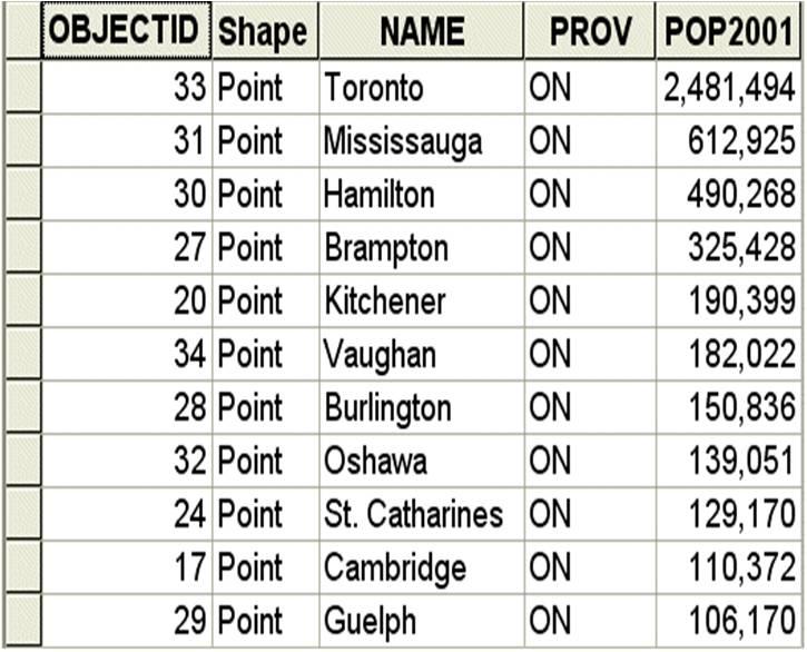
46 Feature class organization Each feature class contains a set of features and attributes Each feature has one record Businesses Streets Businesses attribute table Zoning


47 How is geographic data stored? Geodatabase Primary storage mechanism in ArcGIS Geodatabase with feature classes, a raster dataset, and a stand-alone table

48 Arc Catalog: Data management application Catalog Tree View Contents Panel Right-click an item to view its shortcut menu
49 Consider Do you want to see all the layers in your map all the time? Do you want to see all the features in a layer all the time? What are some ways to control the display of layers and features in ArcMap?

50 Zooming using commands and tools Zoom to Layers Selections Bookmarks Full extent Zoom to selected features

51 Controlling which features display Definition query Query statement defines which features draw Query statement: Attribute field: "SQKM" Operator: > Value: 500 "SQKM" > 500 All lakes are displayed Only lakes larger than 500 square kilometers are displayed


52 Controlling when layers display Scale range Layer turns on or off when scale threshold is crossed Railroads don t display when zoomed out Railroads display when zoomed in to a specified scale 1:5,000,000 1:3,000,000
53 Grouping layers Thematically related layers grouped in the table of contents When Transportation is unchecked, member layers do not draw

54 Creating basemap layers Lakes, Provinces, Countries, and Ocean make up the Basemap layer


55 Making new map layers Create selection layer Left: Parks with lakes are selected Right: Selected parks are saved as new layer Parks Parks Selection Parks
56 What is Symbology?


57 Symbology based on attributes Category: State Name Quantity: Population


58 Categorical data Names Codes Descriptions
59 What is Quantitative data?

60 Quantitative data Count Measurement ELEV


61 Quantitative data Density: POP2001 / SQKM


62 Quantitative symbology based on attributes Colors associated with elevation values ELEV Symbol size associated with population values
63 What is classification and why do we need it?


64 Classification methods Natural Breaks Equal Interval People per sq km People per sq km Quantile Manual People per sq km People per sq km
65 Classification methods Natural Breaks Note: Value 0 indicates less than one person per square kilometer.
66 Classification methods Equal Interval: 0-6; 7-12; 13-18; Note: Value 0 indicates less than one person per square kilometer.
67 Classification methods Quantile Note: Value 0 indicates less than one person per square kilometer.

68 Classification methods Manual: Depends on what you want to show Suppose you want to show Provinces with < or > 10 people per sq km Note: Value 0 indicates less than one person per square kilometer.


69 Where does map text come from?


70 What are labels? Software-generated map text based on attribute values


71 Dynamic label placement Preferred label position is top right 1 2 Positions vary, but all labels fit Mississauga and St. Catharines suppressed to avoid conflict 3


72 Placement rules for different feature types Points Lines Polygons Prefer Top Right, all allowed Curved and Above Line Horizontal
73 Label symbology Font, size, color, more Arial, 14-point, Bold, Purple Heart Character spacing White 2-point halo

74 SQL query Draw labels only for specified attribute values Example: Label only international airports "DESCRIPT" = 'International'


75 Scale range Draw labels at specified scales Example: Label airports only at large scales Scale > 1:2,000,000 Scale < 1:2,000,000

76 Label classes Additional sets of labels for a layer Typically use different symbology Two label classes based on population
![Label expressions Use scripting functions to format labels [NAME] Label expression: &vbnewline & "<FNT](/docs-images/85/92942999/images/77-0.jpg "size='8'>\" & \"Population\" & \"</FNT>\" &vbnewline & \"<CLR red= '168' green= '0' blue='0'>\" & [CSD_POP01] &")
77 Label expressions Use scripting functions to format labels [NAME] Label expression: &vbnewline & "<FNT size='8'>" & "Population" & "</FNT>" &vbnewline & "<CLR red= '168' green= '0' blue='0'>" & [CSD_POP01] & "</CLR>"


78 Ranks and weights Label weight ranking Ordered label classes by priority Assign weight to features and labels (in case of conflict)


79 Map Layout - content considerations Purpose Create map of national park mountain peaks Situation Map will be hung at various park locations and used in map booklets Audience Park visitors, backpackers, rangers, park naturalists, park maintenance staff


80 Data View vs. Layout View Data View Layout View


81 Map elements Title Legend Border Main map Locator map Locator map Logo Scale bar North arrow


82 ArcGIS DESKTOP Ecological Sampling Enables Better Analysis Advancing Geographic Science Integrated Scientific Programming 3D Analysis Statistics Python GIS Time-Aware Analysis & Visualization Math Modeling Background Processing Improved Map Algebra Location & Allocation... Extending Our Quantitative Methods


83 ArcGIS DESKTOP Complete 3D GIS 3D Analysis 3D Editing Fast Visualization Virtual Cities Terrain Updating Video Integration 3D Models - Providing Powerful Data Management, Analysis & Visualization... Removing Limitations & Dramatically Improving Performance


84 ArcGIS DESKTOP Supports time based visualisation New York Katrina Sea Ice... Creating Greater Understanding


85 ArcGIS DESKTOP Applications with 3D Functionality ArcGlobe ArcScene ArcMap ArcCatalog


86 ArcGIS Pro Professional GIS App for the ArcGIS Platform ArcMap & ArcGIS Pro Apps Esri s next-gen 64-bit desktop GIS product is ArcGIS Pro. Technologically ahead of everything else on the market. WebGIS ArcGIS Pro provides professional 2D and 3D mapping in an intuitive user interface. You can think of ArcGIS Pro as a big step forward - one that advances visualization, analytics, image processing, data management, and integration. Desktop Key Features 700+ Geo processing and Analysis Tools Share maps and data Seamlessly work in both 2D and 3D Multiple Layouts Fully integrated with ArcGIS Platform Configure UI through settings, and workflow through Tasks Automate using geoprocessing and Python Extend with the Pro SDK Advanced Mapping, Visualization, Editing and Analysis New and Improved Smart Mapping Editing KML/WFS Map Series Charting
87 GIS on the Web ArcGIS Server, ArcGIS Online, Google Earth, Arc Earth


88 WebGIS Empowers Everyone in Your Organization To Discover, Use, Make, and Share Maps from Any Device, Anywhere, Anytime Making it Easy for Everyone to See How Geography Influences Their Decisions


89 ArcGIS Enterprise Next Generation Server Platform (10.5) App s Access and Management Desktop APIs Portal Portal Data Management, Mapping, and Geoprocessing Real Time GIS Server GeoEvent Server Image Server GeoAnalytics Server Image Management & Raster Analytics Big Data ArcGIS Enterprise Deployable On-Premises and In the Cloud Enterprise Data Management, Analysis, and Mapping


90 ArcGIS for Server enables Web GIS in your infrastructure Desktop Web Device Client applications E.g.: Collector, Dashboard, Explorer, Esri Maps for Apps, and Web AppBuilder Apps Portal Portal for ArcGIS Includes data from ArcGIS Online portal Server Online Content and Services GIS Servers GIS server ArcGIS Web Adaptor, Enterprise geodatabase, ArcGIS Data Store


91 What are GIS services? GIS service GIS resource running on a server -vs. GIS application on your local computer Share GIS resource to the web services Map Feature Network Geodata Geoprocessing Image Locator Schematics
 Programmatic Access to ArcGIS Jupyter Notebooks Scripts Empowering GIS Users... And Opening ArcGIS to Data Scientists")
92 ArcGIS API for Python Enables Scripting and Automation A Whole New Way to Experience and Leverage ArcGIS Command Line Automation Analysis Command Line Scripts Jupyter Notebooks System Administration Python API ArcGIS (Enterprise & Online) Programmatic Access to ArcGIS Jupyter Notebooks Scripts Empowering GIS Users... And Opening ArcGIS to Data Scientists

93 Geographic Web Browser- Google Earth Google Maps is a free web mapping service by Google that provides various types of geographical information. Using Google Maps, one can. Search for places or get directions from one place to another. View and navigate through horizontal and vertical panoramic street level images of various cities around the world. Get specific information like traffic at a particular point. Google Maps provides an API using which you can customize the maps and the information displayed on them.
 = The passive side of Google Maps Allows you to view the basic Google Map content.")

 = The interactive side of Google Maps Create your own content (= your own personal maps), complete")
94 Geographic Web Browser- Google Earth Google Maps ( = The passive side of Google Maps Allows you to view the basic Google Map content. Search for addresses, businesses, places of interest, etc. Base maps: Traffic layer, Map layer, Satellite Layer, Terrain Layer, Earth Layer. Activate Street View by clicking on the orange person and dragging it around the map. Google My Maps ( and click on: My Maps) = The interactive side of Google Maps Create your own content (= your own personal maps), complete with imbedded photographs and YouTube videos. Please note: Google My Maps requires a free Google Account. Browse and use the interactive content created by others. Perform some basic quantitative analysis. Share your maps and content with others.


95 Google Earth 3D With Terrain


96 Adding data to Google Earth


97 ArcGIS Earth ArcGIS Earth is a simple, lightweight, easy-to-use desktop application that allows you to display and explore a variety of 3D and 2D map data for any part of the world. Build skills in these areas: Navigating and exploring ArcGIS Earth Changing the basemap Finding data in the Living Atlas Adding data from a file Sharing your results Explore the world with ArcGIS Earth
98 Extensions of ArcGIS Spatial Analyst, Geostatistical Analyst and 3D Analyst


99 ArcGIS DESKTOP Defense Extensions - Providing Specialized Capabilities Spatial Analysis Logistics Network Analysis 3D Analysis & Visualization Schematics Tracking Publishing Interoperability Survey Business Solutions Business Analytics Workflow Transportation Logistics Map & Data Production Workflow Management Geospatial Intelligence Production Mapping Aeronautical Nautical Mapping Agency Defense Mapping


100 ArcGIS DESKTOP Extensions - Providing Specialized Capabilities Spatial Analyst Suitability Modeling Use ArcGIS Spatial Analyst to select the best location for a new site. Surface Analysis Build and analyze complex surfaces to identify patterns or features. Distance Analysis Calculate the cost of travel, costweighted distance, least-cost path, and shortest path Density Analysis Calculate a density value for each cell in an output raster. Statistical Analysis Apply cell, neighborhood, zonal overlay, and multivariate statistical analysis techniques to the modeling of your spatial data. Solar Radiation Value Wh/m2 High : Low :


101 ArcGIS DESKTOP Extensions - Providing Specialized Capabilities Network Analyst Routing - Multipoint routing - Time windows supported on stops - Traveling salesperson Vehicle Routing Problem - Time windows - Driver breaks and specialties - Vehicle capacities and order quantities Service Areas - Complex polygon generation - Allocation across networks Closest Facility - Fixed and mobile asset routing - Emergency response OD Cost Matrix - Travel time matrix - Maximum destination and distance cutoffs Route Closest Facility Service Area Vehicle Routing Origin-Destination Location-Allocation Problem Cost Matrix


102 ArcGIS DESKTOP Extensions - Providing Specialized Capabilities 3D Analyst Data Visualization - Three-dimensional visualization of your GIS data for data exploration and synthesis Interactive Navigation - Interactive navigation tools to explore, display, and query your three-dimensional data Surface Creation and Analysis - Creation and analysis of surface data for sophisticated modeling, viewing, and analysis 3D Symbols - Support for hundreds of three-dimensional symbols to enhance the display and realism of your data Fly-through Paths and Animations - Creation of advanced fly-throughs and animations for better communication and presentation of important concepts Surface Creation and Analysis 3D Visualisation and Analysis


103 ArcGIS DESKTOP Extensions - Providing Specialized Capabilities Geostatistical Analyst Visualize, model, and predict spatial relationships. Link data, graphs, and maps dynamically. Perform deterministic and geostatistical interpolation. Evaluate models and predictions probabilistically assess risks. s 1 s 2 Moving window direction s n Semivario gram for s 1 Semivario gram for s 2 Semivario gram for s n

104 ArcGIS DESKTOP Extensions - Providing Specialized Capabilities Data Interoperability - Read more than 100 spatial data formats - including GML, XML, WFS, Autodesk DWG/DXF, MicroStation Design, MapInfo MID/MIF and TAB, Oracle and Oracle Spatial, and Intergraph GeoMedia Warehouse. - Share data with anyone - by exporting to more than 70 spatial data formats. - Build complex spatial ETL processes - using FME Workbench, a semantic data translation engine for data transformation, migration, validation, and distribution. - Incorporate these formats and ETL processes - in the geoprocessing framework using tools, ModelBuilder, and scripts
. Dynamically interact with GIS through a schematic view.")
105 ArcGIS DESKTOP Extensions - Providing Specialized Capabilities Schematics Automatically generate schematics from complex networks. Check network connectivity. Perform quality control of network data. Optimize network design and analysis. Evaluate network forecast and planning (modeling, simulation, comparative analysis). Dynamically interact with GIS through a schematic view. Perform commercial and market analyses. Model social networks, generate flowcharts, and manage interdependencies.

106 ArcGIS DESKTOP Extensions - Providing Specialized Capabilities Tracking Analyst Visualize change over time. Symbolize the age of data by color, size, or shape. Group and symbolize data by entity or track. Interactively play back time-based data. Analyze historical or real-time data. Create animation files for AVI output.
107 Useful Resources Software s: ArcGIS Products: Google Maps Tutorials: General: ArcGIS Blog: GeoNet: Reference material and brochures about ESRI products: ArcGIS summary: Spatial Analyst summary: ESRI Virtual Campus provides online training:
108 Useful Resources GIS Data for Global Datasets: Name Description Natural Earth Global Map GSHHG Global Administrative Areas Gridded Population of the World (GPW) Global Roads Open Access Data Set (groads) OpenStreetMap Shaded relief data Bhuvan Earth Explorer ArcGIS Open Data


109 Courtesy: Contents, images used in this presentation are from &
Introduction to the 176A labs and ArcGIS
 Introduction to the 176A labs and ArcGIS Acknowledgement: Slides by David Maidment, U Texas-Austin and Francisco Olivera (TAMU) Purpose of the labs Hands-on experience with one software pakage Introduction
ArcGIS. for Server. Understanding our World
 ArcGIS for Server Understanding our World ArcGIS for Server Create, Distribute, and Manage GIS Services You can use ArcGIS for Server to create services from your mapping and geographic information system
Introduction to the 176A labs and ArcGIS Purpose of the labs
 Introduction to the 176A labs and ArcGIS Purpose of the labs Acknowledgement: Slides by David Maidment, U Texas-Austin and Francisco Olivera (TAMU) Hands-on experience with a leading software package Introduction
Esri Overview for Mentor Protégé Program:
 Agenda Passionate About Helping You Succeed Esri Overview for Mentor Protégé Program: Northrop Grumman CSSS Jeff Dawley 3 September 2010 Esri Overview ArcGIS as a System ArcGIS 10 - Map Production - Mobile
These modules are covered with a brief information and practical in ArcGIS Software and open source software also like QGIS, ILWIS.
 Online GIS Training and training modules covered are: 1. ArcGIS, Analysis, Fundamentals and Implementation 2. ArcGIS Web Data Sharing 3. ArcGIS for Desktop 4. ArcGIS for Server These modules are covered
UNIT 4: USING ArcGIS. Instructor: Emmanuel K. Appiah-Adjei (PhD) Department of Geological Engineering KNUST, Kumasi
 Department of Geological Engineering KNUST, Kumasi") UNIT 4: USING ArcGIS Instructor: Emmanuel K. Appiah-Adjei (PhD) Department of Geological Engineering KNUST, Kumasi Getting to Know ArcGIS ArcGIS is an integrated collection of GIS software products ArcGIS
UNIT 4: USING ArcGIS Instructor: Emmanuel K. Appiah-Adjei (PhD) Department of Geological Engineering KNUST, Kumasi Getting to Know ArcGIS ArcGIS is an integrated collection of GIS software products ArcGIS
Among various open-source GIS programs, QGIS can be the best suitable option which can be used across partners for reasons outlined below.
 Comparison of Geographic Information Systems (GIS) software As of January 2018, WHO has reached an agreement with ESRI (an international supplier of GIS software) for an unlimited use of ArcGIS Desktop
NR402 GIS Applications in Natural Resources
 NR402 GIS Applications in Natural Resources Lesson 1 Introduction to GIS Eva Strand, University of Idaho Map of the Pacific Northwest from http://www.or.blm.gov/gis/ Welcome to NR402 GIS Applications in
Demystifying ArcGIS Online. Karen Lizcano Esri
 Demystifying ArcGIS Online Karen Lizcano Esri An Integrated Web GIS Platform Desktop Web Device Powered by Services Managed via Portal Access from any Device Portal Server Online Content and Services ArcGIS
ArcGIS 10.1 An Overview of the System
 ArcGIS 10.1 An Overview of the System ArcGIS 10.1 An Overview of the System Damian Spangrud Director of Solutions, Esri Redlands, CA USA ArcGIS 10.1 Web Cloud Online Mobile Enterprise Desktop ArcGIS 10.1
How to Pick a GIS. GIS Software Chapter 8 in Longley, Goodchild, Maguire, and Rhind,, 2001
 How to Pick a GIS GIS Software Chapter 8 in Longley, Goodchild, Maguire, and Rhind,, 2001 How to Pick a GIS Evolution of GIS software Architecture of GIS software Types of software Example products The
Introduction to ArcGIS Server Development
 Introduction to ArcGIS Server Development Kevin Deege,, Rob Burke, Kelly Hutchins, and Sathya Prasad ESRI Developer Summit 2008 1 Schedule Introduction to ArcGIS Server Rob and Kevin Questions Break 2:15
Geometric Algorithms in GIS
 Geometric Algorithms in GIS GIS Visualization Software Dr. M. Gavrilova GIS Software for Visualization ArcView GEO/SQL Digital Atmosphere AutoDesk Visual_Data GeoMedia GeoExpress CAVE? Visualization in
INTRODUCTION TO ARCGIS Version 10.*
 Week 3 INTRODUCTION TO ARCGIS Version 10.* topics of the week Overview of ArcGIS Using ArcCatalog Overview of ArcGIS Desktop ArcGIS Overview Scalable desktop applications ArcView ArcEditor ArcInfo ArcGIS
ArcGIS Pro Q&A Session. NWGIS Conference, October 11, 2017 With John Sharrard, Esri GIS Solutions Engineer
 ArcGIS Pro Q&A Session NWGIS Conference, October 11, 2017 With John Sharrard, Esri GIS Solutions Engineer jsharrard@esri.com ArcGIS Desktop The applications ArcGIS Pro ArcMap ArcCatalog ArcScene ArcGlobe
Applications: Introduction Task 1: Introduction to ArcCatalog Task 2: Introduction to ArcMap Challenge Question References
 CHAPTER 1 INTRODUCTION 1.1 GIS? 1.1.1 Components of a GIS 1.1.2 A Brief History of GIS 1.1.3 GIS Software Products Box 1.1 A List of GIS Software Producers and Their Main Products 1.2 GIS Applications
ArcGIS is Advancing. Both Contributing and Integrating many new Innovations. IoT. Smart Mapping. Smart Devices Advanced Analytics
 ArcGIS is Advancing IoT Smart Devices Advanced Analytics Smart Mapping Real-Time Faster Computing Web Services Crowdsourcing Sensor Networks Both Contributing and Integrating many new Innovations ArcGIS
Innovation. The Push and Pull at ESRI. September Kevin Daugherty Cadastral/Land Records Industry Solutions Manager
 Innovation The Push and Pull at ESRI September 2004 Kevin Daugherty Cadastral/Land Records Industry Solutions Manager The Push and The Pull The Push is the information technology that drives research and
Lecture 2. Introduction to GIS Software and Resources
 Lecture 2 Introduction to GIS Software and Resources GIS in Water Resources Spring 2015 Introduction to GIS Software there are others. Proprietary: 1 Introduction to GIS Software and even more. OpenSource:
Changes in Esri GIS, practical ways to be ready for the future
 Changes in Esri GIS, practical ways to be ready for the future John Sharrard, Esri April 16, 2015 The only thing that is constant is change. Heraclitus, ca. 500 B.C. My story (of experiencing change) Changes
ESRI Survey Summit August Clint Brown Director of ESRI Software Products
 ESRI Survey Summit August 2006 Clint Brown Director of ESRI Software Products Cadastral Fabric How does Cadastral fit with Survey? Surveyors process raw field observations Survey measurements define high-order
DP Project Development Pvt. Ltd.
 Dear Sir/Madam, Greetings!!! Thanks for contacting DP Project Development for your training requirement. DP Project Development is leading professional training provider in GIS technologies and GIS application
Geodatabase Management Pathway
 Geodatabase Management Pathway Table of Contents ArcGIS Desktop II: Tools and Functionality 3 ArcGIS Desktop III: GIS Workflows and Analysis 6 Building Geodatabases 8 Data Management in the Multiuser Geodatabase
Why GIS & Why Internet GIS?
 Why GIS & Why Internet GIS? The Internet bandwagon Internet mapping (e.g., MapQuest) Location-based services Real-time navigation (e.g., traffic) Real-time service dispatch Business Intelligence Spatial
Exelis and Esri Technologies for Defense and National Security. Cherie Muleh
 Exelis and Esri Technologies for Defense and National Security Cherie Muleh Cherie.Muleh@exelisinc.com ENVI IMAGERY AND DATA BECOME KNOWLEDGE > Add information from imagery to your GIS > Automated workflows
Imagery and the Location-enabled Platform in State and Local Government
 Imagery and the Location-enabled Platform in State and Local Government Fred Limp, Director, CAST Jim Farley, Vice President, Leica Geosystems Oracle Spatial Users Group Denver, March 10, 2005 TM TM Discussion
Environmental Systems Research Institute
 Introduction to ArcGIS ESRI Environmental Systems Research Institute Redlands, California 2 ESRI GIS Development Arc/Info (coverage model) Versions 1-7 from 1980 1999 Arc Macro Language (AML) ArcView (shapefile
Introduction to ArcGIS Server - Creating and Using GIS Services. Mark Ho Instructor Washington, DC
 Introduction to ArcGIS Server - Creating and Using GIS Services Mark Ho Instructor Washington, DC Technical Workshop Road Map Product overview Building server applications GIS services Developer Help resources
GENERALIZATION IN THE NEW GENERATION OF GIS. Dan Lee ESRI, Inc. 380 New York Street Redlands, CA USA Fax:
 GENERALIZATION IN THE NEW GENERATION OF GIS Dan Lee ESRI, Inc. 380 New York Street Redlands, CA 92373 USA dlee@esri.com Fax: 909-793-5953 Abstract In the research and development of automated map generalization,
Popular Mechanics, 1954
 Introduction to GIS Popular Mechanics, 1954 1986 $2,599 1 MB of RAM 2017, $750, 128 GB memory, 2 GB of RAM Computing power has increased exponentially over the past 30 years, Allowing the existence of
Write a report (6-7 pages, double space) on some examples of Internet Applications. You can choose only ONE of the following application areas:
 on some examples of Internet Applications. You can choose only ONE of the following application areas:") UPR 6905 Internet GIS Homework 1 Yong Hong Guo September 9, 2008 Write a report (6-7 pages, double space) on some examples of Internet Applications. You can choose only ONE of the following application
UPR 6905 Internet GIS Homework 1 Yong Hong Guo September 9, 2008 Write a report (6-7 pages, double space) on some examples of Internet Applications. You can choose only ONE of the following application
GIS Software. Evolution of GIS Software
 GIS Software The geoprocessing engines of GIS Major functions Collect, store, mange, query, analyze and present Key terms Program collections of instructions to manipulate data Package integrated collection
Data Aggregation with InfraWorks and ArcGIS for Visualization, Analysis, and Planning
 Data Aggregation with InfraWorks and ArcGIS for Visualization, Analysis, and Planning Stephen Brockwell President, Brockwell IT Consulting, Inc. Join the conversation #AU2017 KEYWORD Class Summary Silos
Esri WebGIS Highlights of What s New, and the Road Ahead
 West Virginia GIS Conference WVU, Morgantown, WV Esri WebGIS Highlights of What s New, and the Road Ahead Mark Scott, Solutions Engineer, Esri Local Government Team May 5 th, 2016 West Virginia GIS Conference
Leveraging Web GIS: An Introduction to the ArcGIS portal
 Leveraging Web GIS: An Introduction to the ArcGIS portal Derek Law Product Management DLaw@esri.com Agenda Web GIS pattern Product overview Installation and deployment Configuration options Security options
Geospatial Products V8i (SELECTseries 1)
") Geospatial Products V8i (SELECTseries 1) Keith Raymond Product Manager Geospatial Desktop Products Presentation Overview What are the various products? Why would you need them? Demonstrations 2 WWW.BENTLEY.COM
Geospatial Products V8i (SELECTseries 1) Keith Raymond Product Manager Geospatial Desktop Products Presentation Overview What are the various products? Why would you need them? Demonstrations 2 WWW.BENTLEY.COM
GIS Boot Camp for Education June th, 2011 Day 1. Instructor: Sabah Jabbouri Phone: (253) x 4854 Office: TC 136
 x 4854 Office: TC 136") GIS Boot Camp for Education June 27-30 th, 2011 Day 1 Instructor: Sabah Jabbouri Phone: (253) 833-9111 x 4854 Office: TC 136 Email: sjabbouri@greenriver.edu http://www.instruction.greenriver.edu/gis/ Summer
GIS Boot Camp for Education June 27-30 th, 2011 Day 1 Instructor: Sabah Jabbouri Phone: (253) 833-9111 x 4854 Office: TC 136 Email: sjabbouri@greenriver.edu http://www.instruction.greenriver.edu/gis/ Summer
Enabling ENVI. ArcGIS for Server
 Enabling ENVI throughh ArcGIS for Server 1 Imagery: A Unique and Valuable Source of Data Imagery is not just a base map, but a layer of rich information that can address problems faced by GIS users. >
Introduction to Geographic Information Systems
 Introduction to Geographic Information Systems Lynn_Carlson@brown.edu 401-863-9917 The Environmental And Remote TecHnologies Lab MacMillan Hall, Room 105 http://www.brown.edu/research/earthlab/ Outline
Esri User Conference 2018 Video Topics
 Esri User Conference 2018 Video Topics 3D GIS 3D Across ArcGIS 3D Analysis Tools in ArcGIS Pro 3D Cartographic Techniques: An Introduction 3D Data: Lidar Point Clouds and 3D Mesh 3D Feature and Sub-Surface
Portal for ArcGIS: An Introduction. Catherine Hynes and Derek Law
 Portal for ArcGIS: An Introduction Catherine Hynes and Derek Law Agenda Web GIS pattern Product overview Installation and deployment Configuration options Security options and groups Portal for ArcGIS
Overview of Geospatial Open Source Software which is Robust, Feature Rich and Standards Compliant
 Overview of Geospatial Open Source Software which is Robust, Feature Rich and Standards Compliant Cameron SHORTER, Australia Key words: Open Source Geospatial Foundation, OSGeo, Open Standards, Open Geospatial
ArcGIS Earth for Enterprises DARRON PUSTAM ARCGIS EARTH CHRIS ANDREWS 3D
 ArcGIS Earth for Enterprises DARRON PUSTAM ARCGIS EARTH CHRIS ANDREWS 3D ArcGIS Earth is ArcGIS Earth is a lightweight globe desktop application that helps you explore any part of the world and investigate
The Pace of Change Is Accelerating Creating Many Challenges
 VISION The Pace of Change Is Accelerating Creating Many Challenges Evidence Threatening Our Natural World and Our Future as Humans Social Conflict Mass Migration Ocean Acidification Food Population Urbanization
How does ArcGIS Server integrate into an Enterprise Environment? Willy Lynch Mining Industry Specialist ESRI, Denver, Colorado USA
 How does ArcGIS Server integrate into an Enterprise Environment? Willy Lynch Mining Industry Specialist ESRI, Denver, Colorado USA wlynch@esri.com ArcGIS Server Technology Transfer 1 Agenda Who is ESRI?
You are Building Your Organization s Geographic Knowledge
 You are Building Your Organization s Geographic Knowledge And Increasingly Making it Available Sharing Data Publishing Maps and Geo-Apps Developing Collaborative Approaches Citizens Knowledge Workers Analysts
GIS-based Smart Campus System using 3D Modeling
 GIS-based Smart Campus System using 3D Modeling Smita Sengupta GISE Advance Research Lab. IIT Bombay, Powai Mumbai 400 076, India smitas@cse.iitb.ac.in Concept of Smart Campus System Overview of IITB Campus
A Review: Geographic Information Systems & ArcGIS Basics
 A Review: Geographic Information Systems & ArcGIS Basics Geographic Information Systems Geographic Information Science Why is GIS important and what drives it? Applications of GIS ESRI s ArcGIS: A Review
Working with the Geodatabase
 Working with the Geodatabase Agenda What is the geodatabase? Benefits of the geodatabase Inside the geodatabase Geodatabase rules Demos Additional resources and training Q & A The Geodatabase is the foundation
Introduction to ArcGIS 10.2
 Introduction to ArcGIS 10.2 Francisco Olivera, Ph.D., P.E. Srikanth Koka Lauren Walker Aishwarya Vijaykumar Keri Clary Department of Civil Engineering April 21, 2014 Contents Brief Overview of ArcGIS 10.2...
ArcGIS Enterprise: What s New. Philip Heede Shannon Kalisky Melanie Summers Sam Williamson
 ArcGIS Enterprise: What s New Philip Heede Shannon Kalisky Melanie Summers Sam Williamson ArcGIS Enterprise is the new name for ArcGIS for Server What is ArcGIS Enterprise ArcGIS Enterprise is powerful
Migrating Defense Workflows from ArcMap to ArcGIS Pro. Renee Bernstein and Jared Sellers
 Migrating Defense Workflows from ArcMap to ArcGIS Pro Renee Bernstein and Jared Sellers ArcGIS Desktop Desktop Web Device ArcMap ArcCatalog ArcScene ArcGlobe ArcGIS Pro portal Server Online Content and
Bentley Map Advancing GIS for the World s Infrastructure
 Bentley Map Advancing GIS for the World s Infrastructure Presentation Overview Why would you need Bentley Map? What is Bentley Map? Where is Bentley Map Used? Why would you need Bentley Map? Because your
ArcGIS Runtime: Migrating Your Apps from ArcGIS Engine. Eric Bader Lucas Danzinger Mike Branscomb
 ArcGIS Runtime: Migrating Your Apps from ArcGIS Engine Eric Bader Lucas Danzinger Mike Branscomb Migrating to ArcGIS Runtime ArcGIS Engine ArcGIS Runtime AppStudio for ArcGIS Apps: Collector, Workforce,
Outline. Chapter 1. A history of products. What is ArcGIS? What is GIS? Some GIS applications Introducing the ArcGIS products How does GIS work?
 Outline Chapter 1 Introducing ArcGIS What is GIS? Some GIS applications Introducing the ArcGIS products How does GIS work? Basic data formats The ArcCatalog interface 1-1 1-2 A history of products Arc/Info
Esri Training by Microcenter Prepare to Innovate. Microcenter Course Catalog
 Esri Training by Microcenter Prepare to Innovate 2015 Instructor-Led Courses Microcenter Course Catalog ArcGIS Foundational Courses Designed to meet the learning needs of professionals whose GIS experience
October 2011 ArcGIS 10 for Server Functionality Matrix
 October 2011 ArcGIS 10 for Server Functionality Matrix Esri, 380 New York St., Redlands, CA 92373-8100 USA TEL 909-793-2853 FAX 909-793-5953 E-MAIL info@esri.com WEB www.esri.com Copyright 2011 Esri All
Introduction to Portal for ArcGIS
 Introduction to Portal for ArcGIS Derek Law Product Management March 10 th, 2015 Esri Developer Summit 2015 Agenda Web GIS pattern Product overview Installation and deployment Security and groups Configuration
DATA SCIENCE SIMPLIFIED USING ARCGIS API FOR PYTHON
 DATA SCIENCE SIMPLIFIED USING ARCGIS API FOR PYTHON LEAD CONSULTANT, INFOSYS LIMITED SEZ Survey No. 41 (pt) 50 (pt), Singapore Township PO, Ghatkesar Mandal, Hyderabad, Telengana 500088 Word Limit of the
Esri UC2013. Technical Workshop.
 Esri International User Conference San Diego, California Technical Workshops July 9, 2013 CAD: Introduction to using CAD Data in ArcGIS Jeff Reinhart & Phil Sanchez Agenda Overview of ArcGIS CAD Support
GIS CONCEPTS ARCGIS METHODS AND. 3 rd Edition, July David M. Theobald, Ph.D. Warner College of Natural Resources Colorado State University
 GIS CONCEPTS AND ARCGIS METHODS 3 rd Edition, July 2007 David M. Theobald, Ph.D. Warner College of Natural Resources Colorado State University Copyright Copyright 2007 by David M. Theobald. All rights
December 2009 ArcGIS Server Functionality Matrix
 December 2009 ArcGIS Server 9.3.1 Functionality Matrix ESRI 380 New York St., Redlands, CA 92373-8100 USA TEL 909-793-2853 FAX 909-793-5953 E-MAIL info@esri.com WEB www.esri.com Copyright 2009 ESRI All
Lecture 2. Introduction to ESRI s ArcGIS Desktop and ArcMap
 Lecture 2 Introduction to ESRI s ArcGIS Desktop and ArcMap Outline ESRI What is ArcGIS? ArcGIS Desktop ArcMap Overview Views Layers Attribute Tables Help! Scale Tips and Tricks ESRI Environmental Systems
Incorporating ArcGIS Pro in your Curriculum
 AAG, Boston 2017 April 5, 2017 Incorporating ArcGIS Pro in your Curriculum Geri Miller Agenda Concerns Acknowledged Learning curve ArcGIS Pro does not have all the tools (perception) Licensing and offline
ArcGIS for Desktop. ArcGIS for Desktop is the primary authoring tool for the ArcGIS platform.
 ArcGIS for Desktop ArcGIS for Desktop ArcGIS for Desktop is the primary authoring tool for the ArcGIS platform. Beyond showing your data as points on a map, ArcGIS for Desktop gives you the power to manage
Features and Benefits
 Autodesk LandXplorer Features and Benefits Use the Autodesk LandXplorer software family to help improve decision making, lower costs, view and share changes, and avoid the expense of creating physical
Experiences and Directions in National Portals"
 FIG Seminar on e-land Administration Innsbruck/Austria 2-4 June 2004 "ESRI's Experiences and Directions in National Portals" Kevin Daugherty Cadastral/Land Records Manager ESRI Topic Points Technology
GIS = Geographic Information Systems;
 What is GIS GIS = Geographic Information Systems; What Information are we talking about? Information about anything that has a place (e.g. locations of features, address of people) on Earth s surface,
Week 01 Lecture Notes Antelope Valley College Geography 205
 I. Introduction to GIS a. Tonight we ll discuss i. What GIS is and isn t ii. Software iii. Data iv. Documents v. File Structure II. GIS a. What it is i. Geographic Information Systems ii. A way of storing,
Introduction to Portal for ArcGIS. Hao LEE November 12, 2015
 Introduction to Portal for ArcGIS Hao LEE November 12, 2015 Agenda Web GIS pattern Product overview Installation and deployment Security and groups Configuration options Portal for ArcGIS + ArcGIS for
Discovery and Access of Geospatial Resources using the Geoportal Extension. Marten Hogeweg Geoportal Extension Product Manager
 Discovery and Access of Geospatial Resources using the Geoportal Extension Marten Hogeweg Geoportal Extension Product Manager DISCOVERY AND ACCESS USING THE GEOPORTAL EXTENSION Geospatial Data Is Very
Portal for ArcGIS: An Introduction
 Portal for ArcGIS: An Introduction Derek Law Esri Product Management Esri UC 2014 Technical Workshop Agenda Web GIS pattern Product overview Installation and deployment Security and groups Configuration
Fundamentals of ArcGIS Desktop Pathway
 Fundamentals of ArcGIS Desktop Pathway Table of Contents ArcGIS Desktop I: Getting Started with GIS 3 ArcGIS Desktop II: Tools and Functionality 5 Understanding Geographic Data 8 Understanding Map Projections
Web GIS & ArcGIS Pro. Zena Pelletier Nick Popovich
 Web GIS & ArcGIS Pro Zena Pelletier Nick Popovich Web GIS Transformation of the ArcGIS Platform Desktop Apps GIS Web Maps Web Scenes Layers Evolution of the modern GIS Desktop GIS (standalone GIS) GIS
A Vision for ArcGIS Applying Geography Everywhere
 A Vision for ArcGIS Applying Geography Everywhere WELCOME PURPOSE A Network of GIS Professionals Are Awakening the World to the Power of Web GIS You Your WORK Making a Difference Your Work Open Maps and
Lecture 1 Introduction to GIS. Dr. Zhang Spring, 2017
 Lecture 1 Introduction to GIS Dr. Zhang Spring, 2017 Topics of the course Using and making maps Navigating GIS Map design Working with spatial data Geoprocessing Spatial data infrastructure Digitizing
ArcGIS Enterprise: What s New. Philip Heede Shannon Kalisky Melanie Summers Shreyas Shinde
 ArcGIS Enterprise: What s New Philip Heede Shannon Kalisky Melanie Summers Shreyas Shinde ArcGIS Enterprise is the new name for ArcGIS for Server ArcGIS Enterprise Software Components ArcGIS Server Portal
Karsten Vennemann, Seattle. QGIS Workshop CUGOS Spring Fling 2015
 Karsten Vennemann, Seattle 2015 a very capable and flexible Desktop GIS QGIS QGIS Karsten Workshop Vennemann, Seattle slide 2 of 13 QGIS - Desktop GIS originally a GIS viewing environment QGIS for the
ESRI Quality Solution
 ESRI Quality Solution Paul Hardy Business Development Consultant (NMCAs) ESRI Europe phardy@esri.com ESRI Quality Solution Geodatabase Integrity Schema constraints (Attribute Domains etc) Rich data types
Spatial Data Infrastructure Concepts and Components. Douglas Nebert U.S. Federal Geographic Data Committee Secretariat
 Spatial Data Infrastructure Concepts and Components Douglas Nebert U.S. Federal Geographic Data Committee Secretariat August 2009 What is a Spatial Data Infrastructure (SDI)? The SDI provides a basis for
G EOSPAT I A L ERDAS IMAGINE. The world s most widely-used software package for creating information from geospatial data
 G EOSPAT I A L ERDAS IMAGINE The world s most widely-used software package for creating information from geospatial data ERDAS IMAGINE Geographic imaging professionals need to process vast amounts of
EEOS 381 -Spatial Databases and GIS Applications
 EEOS 381 -Spatial Databases and GIS Applications Lecture 5 Geodatabases What is a Geodatabase? Geographic Database ESRI-coined term A standard RDBMS that stores and manages geographic data A modern object-relational
ArcGIS Runtime: Migrating from ArcGIS Engine. Rex Hansen
 ArcGIS Runtime: Migrating from ArcGIS Engine Rex Hansen Thank You to Our Sponsors Migrating from ArcGIS Engine to ArcGIS Runtime ArcGIS Runtime API: new and evolved workflows on all platforms Windows Linux
This Week is All About GIS, Geography and Sharing Our Knowledge
 Stockholm 2007 1 This Week is All About GIS, Geography and Sharing Our Knowledge Technology Methods Organization Data Processes Standards Projects Visualization And About You Applications Mapping Data
Bentley Map Advancing GIS for the World s Infrastructure
 Bentley Map Advancing GIS for the World s Infrastructure Presentation Overview Why would you need Bentley Map? What is Bentley Map? Where is Bentley Map Used? Red text signifies new things in Bentley Map
Network Analysis with ArcGIS Online. Deelesh Mandloi Dmitry Kudinov
 Deelesh Mandloi Dmitry Kudinov Introductions Who are we? - Network Analyst Product Engineers Who are you? - Network Analyst users? - ArcGIS Online users? - Trying to figure out what is ArcGIS Online? Slides
GIS CONCEPTS ARCGIS METHODS AND. 2 nd Edition, July David M. Theobald, Ph.D. Natural Resource Ecology Laboratory Colorado State University
 GIS CONCEPTS AND ARCGIS METHODS 2 nd Edition, July 2005 David M. Theobald, Ph.D. Natural Resource Ecology Laboratory Colorado State University Copyright Copyright 2005 by David M. Theobald. All rights
Working with ArcGIS Online
 Esri International User Conference San Diego, CA Technical Workshops July 12, 2011 Working with ArcGIS Online Bern Szukalski, Deane Kensok Topics for this Session ArcGIS Online Overview ArcGIS Online Content
Learning ArcGIS: Introduction to ArcCatalog 10.1
 Learning ArcGIS: Introduction to ArcCatalog 10.1 Estimated Time: 1 Hour Information systems help us to manage what we know by making it easier to organize, access, manipulate, and apply knowledge to the
ESRI Object Models and Data Capture 2/1/2018
 Number 123 124 125 ESRI* Object Models; Data Capture Feature Class (spatial table) Age_Ma 142 136 1_sigma 1.5 2.0 Rx_Type B_schist G_schist Object Class (nonspatial table) Size_kg 3.4 1.3 Y Control Point
Geodatabase An Introduction
 2013 Esri International User Conference July 8 12, 2013 San Diego, California Technical Workshop Geodatabase An Introduction David Crawford and Jonathan Murphy Session Path The Geodatabase What is it?
Course overview. Grading and Evaluation. Final project. Where and When? Welcome to REM402 Applied Spatial Analysis in Natural Resources.
 Welcome to REM402 Applied Spatial Analysis in Natural Resources Eva Strand, University of Idaho Map of the Pacific Northwest from http://www.or.blm.gov/gis/ Where and When? Lectures Monday & Wednesday
GIS-T 2010 Building a Successful Geospatial Data Sharing Framework: A Ohio DOT Success Story
 GIS-T 2010 Building a Successful Geospatial Data Sharing Framework: A Ohio DOT Success Story ODOT District 2 GIS John Puente District 1 GIS Coordinator\ Planning Administrator 2 Interoperability 3 District
(THIS IS AN OPTIONAL BUT WORTHWHILE EXERCISE)
") PART 2: Analysis in ArcGIS (THIS IS AN OPTIONAL BUT WORTHWHILE EXERCISE) Step 1: Start ArcCatalog and open a geodatabase If you have a shortcut icon for ArcCatalog on your desktop, double-click it to start
PART 2: Analysis in ArcGIS (THIS IS AN OPTIONAL BUT WORTHWHILE EXERCISE) Step 1: Start ArcCatalog and open a geodatabase If you have a shortcut icon for ArcCatalog on your desktop, double-click it to start
Building a National Data Repository
 Building a National Data Repository Mladen Stojic, Vice President - Geospatial 1/30/2013 2012 Intergraph Corporation 1 Information has meaning and gives power only when shared and distributed. Information,
Spatial Analysis with Web GIS. Rachel Weeden
 Spatial Analysis with Web GIS Rachel Weeden Agenda Subhead goes here Introducing ArcGIS Online Spatial Analysis Workflows Scenarios Other Options Resources ArcGIS is a Platform Making mapping and analytics
Bentley Map V8i (SELECTseries 3)
") Bentley Map V8i (SELECTseries 3) A quick overview Why Bentley Map Viewing and editing of geospatial data from file based GIS formats, spatial databases and raster Assembling geospatial/non-geospatial data
Bentley Map V8i (SELECTseries 3) A quick overview Why Bentley Map Viewing and editing of geospatial data from file based GIS formats, spatial databases and raster Assembling geospatial/non-geospatial data
ESRI* Object Models; Data Capture
 ESRI* Object Models; Data Capture * Environmental Systems Research Institute Feature Class (spatial table) Number Age_Ma 1_sigma Rx_Type Size_kg 123 124 125 142 1.5 B_schist 136 2.0 G_schist Object Class
ESRI Object Models and Data Capture 9/18/ /18/2014 M. Helper GEO327G/386G, UT Austin 2. ESRI Arc/Info ArcView ArcGIS
 ESRI Object Models; Data Capture Conceptual Models Conceptual Models Characterized all features or phenomena as: Feature Class (spatial table) Number Age_Ma 1_sigma Rx_Type 123 142 1.5 B_schist 124 136
ArcGIS for INSPIRE. Marten Hogeweg Satish Sankaran
 ArcGIS for INSPIRE Marten Hogeweg Satish Sankaran Outline What is ArcGIS ArcGIS for INSPIRE Web GIS Case Studies Roadmap Q&A What is INSPIRE? INSPIRE is the legal framework for a European Spatial Data