Lecture 2. Introduction to GIS Software and Resources
|
|
|
- Felicia O’Connor’
- 6 years ago
- Views:
Transcription


1 Lecture 2 Introduction to GIS Software and Resources GIS in Water Resources Spring 2015 Introduction to GIS Software there are others. Proprietary: 1

2 Introduction to GIS Software and even more. OpenSource: Introduction to GIS Software and more notables. OpenSource: 2


3 Introduction to GIS Software and more notables with WATER. OpenSource: "A GIS-based Platform for Environmental and Water Resources Modeling - Kalypso Open Source", Publication in GEO Informatics magazine, March You will work with this one! Introduction to ArcGIS Software ESRI centric 3

4 ESRI Online Reference Materials ArcGIS summary: ArcGIS Desktop summary: Spatial Analyst summary: ESRI Virtual Campus provides online training The first three items are readings for this class ArcGIS Resource Center Please familiarize yourself with this information. Notice: we are using V and not


5 ESRi Virtual Campus Extensive set of online training courses, self paced on a number of topics. You will be doing 2 of those. Please familiarize yourself with this information ArcGIS Online Please familiarize yourself with this information 5

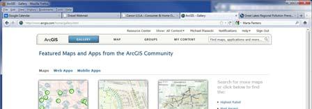
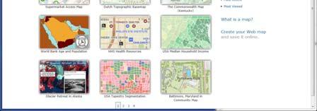
6 ArcGIS Online Description: Please familiarize yourself with this information ArcGIS Online Share Maps and Apps 6


 - Modify")
7 ArcGIS Marketplace Share Apps: Use following SDKs: Android & ios & JavaScript Great Class Project! Need a developer account! Same general ESRI login credentials ArcGIS Online Explorer Build your own: - import maps via WebMapService (WMS) - Modify and build your own layers - Export your own 7


 Load")

8 ArcGIS Online Explorer ArcGIS Online Explorer 3) Load from WMS Add your own content to BaseMap 1) Load file 2) Draw your own 8

9 Query for sites with Nitrogen data and at least 50 observed values East Fork Watershed Sites in ArcGIS Explorer Online (in a private group) 9
 Selected Sites Satisfying this Query Selected site Info on a selected")
10 Query for sites with Nitrogen data and at least 50 observed values You can only query on Features!! Hence you need import a WebFeatureService (WFS) Selected Sites Satisfying this Query Selected site Info on a selected site Non-selected site 10


11 WaterML Response for Time Series Introduction to GIS Software How data are stored in ArcGIS Components of ArcGIS ArcMap, ArcCatalog and ArcToolbox GIS on the Web ArcGIS Server, ArcGIS Online, Google Earth. Extensions of ArcGIS spatial analyst, geostatistical analyst and 3D analyst 11
12 ESRI GIS Development Arc/Info (coverage model) Versions 1-7 from Arc Macro Language (AML) ArcView (shapefile model) Versions 1-3 from Avenue scripting language 160,000 licenses 1,200,000 users as of 2009 ArcGIS (geodatabase model) Version 8.0,, 10.0 from 2000 Python scripting Geographic Data Models All geographic information systems are built using formal models that describe how things are located in space. A formal model is an abstract and well-defined system of concepts. A geographic data model defines the vocabulary for describing and reasoning about the things that are located on the earth. Geographic data models serve as the foundation on which all geographic information systems are built. Scott Morehouse, Preface to Modeling our World 12
13 Data Models A geographic data model is a structure for organizing geospatial data so that it can be easily stored and retrieved. Geographic coordinates Tabular attributes Arc File-based Data Models Geographic coordinates and attributes are stored in separate but linked files Coverages Developed for workstation Arc/Info ~ 1980 Complex structure, proprietary format Attributes in Info tables Info Shapefiles Developed for ArcView ~ 1993 Simpler structure in public domain Attributes in dbase (.dbf) tables 13


14 Storing Data Coverages Shapefiles Texas Texas.e00 extension Counties Evap Info Counties.shp Counties.shx Counties.dbf Evap.shp Evap.shx Evap.dbf Coverages Storing Data Shapefiles From: Understanding Topology and Shapefiles by David M. Theobald, Colorado State University Planar Enforcement through topologically structured polygons Another important consequence of planar enforcement is that a map that has topology contains space-filling, nonoverlapping polygons. In addition, shapefiles can easily be copied and do not require importing or exporting as do.e00 format files. 14
15 Shapefiles Texas Counties.shp Counties.shx Counties.dbf Evap.shp Evap.shx Evap.dbf Storing Data 3 Mandatory files :.shp shape format; the feature geometry itself.shx shape index format; a positional index of the feature geometry to allow seeking forwards and backwards quickly.dbf attribute format; columnar attributes for each shape, in dbase IV format 8 Optional files :.prj projection format; the coordinate system and projection information, a plain text file describing the projection using well-known text format.sbn and.sbx a spatial index of the features.fbn and.fbx a spatial index of the features for shapefiles that are read-only.ain and.aih an attribute index of the active fields in a table or a theme's attribute table.ixs a geocoding index for read-write shapefiles.mxs a geocoding index for read-write shapefiles (ODB format).atx an attribute index for the.dbf file in the form of shapefile.columnname.atx (ArcGIS 8 and later).shp.xml geospatial metadata in XML format, such as ISO or other schemas.cpg used to specify the code page (only for.dbf) for identifying the character encoding to be used Storing Data Coverages and Shapefiles Coverages are stored partially in their own folder (ARC) and partially in the common INFO folder. Shapefiles are stored in three to five files (with extensions.shp,.shx,.dbf,.sbx and.sbn). Coverages store common boundaries between polygons only once, to avoid redundancy. Shapefiles store all the geometry of each polygon regardless of redundancy. Coverage features are single lines or single polygons. Shapefiles allow features to have multiple, disconnected, intersecting and overlapping components. A primary advantage of shapefiles is that this simple file structure draws faster than a coverage does. 15
16 Geodatabase and Feature Dataset A geodatabase is a relational database that stores geographic information. A feature dataset is a collection of feature classes that share the same spatial reference frame. Geodatabase model Stores geographic coordinates as one attribute (shape) in a relational database table Uses MS Access for Personal Geodatabase (single user) Uses Oracle, SQL/Server, db2 or other commercial relational databases for Enterprise Geodatabases (many simultaneous users) Uses files in File Geodatabase Shape 16


17 ArcGIS Geodatabase Workspace Geodatabase Feature Dataset Feature Class Geometric Network Relationship Object Class Object Class An object class is a collection of objects in tabular format that have the same behavior and the same attributes. An object class is a table that has a unique identifier (ObjectID) for each record 17


18 A feature class is a collection of geographic objects in tabular format that have the same behavior and the same attributes. Feature Class Feature Class = Object class + spatial coordinates Relationship A relationship is an association or link between two objects in a database. A relationship can exist between spatial objects (features in feature classes), nonspatial objects (objects in object classes), or between spatial and non-spatial objects. 18

 Measurement station")
19 Relationship Relationship between non-spatial objects Water Quality Data Water Quality Parameters Relationship Relationship between spatial and non-spatial objects Water quality data (non-spatial) Measurement station (spatial) 19
20 Network A network is a set of edges (lines) and junctions (points) that are topologically connected to each other. Each edge knows which junctions are at its endpoints Each junction knows which edges it connects to Introduction to GIS Software How data are stored in ArcGIS Components of ArcGIS ArcMap, ArcCatalog and ArcToolbox GIS on the Web ArcGIS Server, ArcGIS Online. Extensions of ArcGIS spatial analyst, geostatistical analyst and 3D analyst 20
 Create maps")
 Arc Catalog Tables")
21 View and edit data Arc Map Analyze data (Geoprocessing) Create maps Graphical previews View data (like Windows Explorer) Arc Catalog Tables Metadata 21


22 Arc Toolbox Tools for commonly used tasks Map Projections Geo-Processing Toolbox tools linked together using the model builder to automate data processing 22
 as well License manager The license manager keeps track of number of simultaneous users and limits them to allowable number.")
23 Levels of ArcGIS ArcView View data and do edits on shape files and simple personal geodatabases ArcEditor do more complex edits on enterprise geodatabases ArcInfo the full system, with access to workstation ArcInfo (i.e. ArcInfo version 7) as well License manager The license manager keeps track of number of simultaneous users and limits them to allowable number. If you can t get an available license in St 424, ask the lab manager to restart the ArcGIS license manager. At CCNY contact David Santoro to get the license manager restarted dsantoro@ccny.cuny.edu. His telephone is: (212)

24 Introduction to GIS Software How data are stored in ArcGIS Components of ArcGIS ArcMap, ArcCatalog and ArcToolbox GIS on the Web ArcGIS Server, ArcGIS Online, Google Earth. Extensions of ArcGIS spatial analyst, geostatistical analyst and 3D analyst Desktop, Server, Web Desktop GIS 24

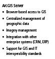
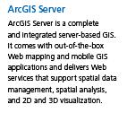
25 ArcGIS Desktop ArcGIS Server 25


26 CRWR Data Services Receiving Service in ArcCatalog Publishing Service in ArcGIS Server Workstation-centered GIS Web ArcGIS Desktop Local Enterprise Next 4 slides from Scott Morehouse, ESRI 26

27 Enterprise-centered GIS ArcGIS Server Web-centered GIS ArcGIS Online 27


28 An Integrated Systems Approach ArcGIS Online ArcGIS Desktop ArcGIS Server 28


29 Multiscale Tiled Images Small Scale: Little detail, broad coverage 1:1,000,000 Large Scale: Great detail, narrow coverage 1:1,000 World Topographic Base Map Cartographic map built from GIS data With content added by the City of Austin 29


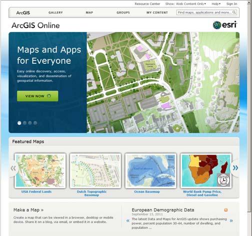
30 Bing Maps in ArcGIS.com Google Earth Geographic Web Browser 30


31 Google Earth 3D With Terrain Adding data to Google Earth 31

32 Observations Data and Google Earth Bear River Introduction to GIS Software How data are stored in ArcGIS Components of ArcGIS ArcMap, ArcCatalog and ArcToolbox GIS on the Web ArcGIS Server, ArcGIS Online, Google Earth. Extensions of ArcGIS spatial analyst, geostatistical analyst and 3D analyst 32


33 ArcGIS Extensions Spatial Analyst Analysis of land surface terrain as a grid Key means of defining drainage areas and connectivity to stream network 33

, as well as the value at each cell have to be")

34 Grid Datasets Cellular-based data structure composed of square cells of equal size arranged in rows and columns. The grid cell size and extension (number of rows and columns), as well as the value at each cell have to be stored as part of the grid definition. Number of columns Number of rows Cell size Grid Datasets Grid datasets 34


35 Geostatistical Analyst Interpolation of points to a grid using statistical correlation Produces a standard error of estimate of each map location Siberia Alaska Biomass in the Arctic Ocean Image Datasets Digital Orthophotos and satellite imagery Image datasets 35
![Image Datasets Supported image formats: ARC Digitized Raster Graphics (ADRG) Windows bitmap images (BMP) [.bmp] Multiband (BSQ, BIL and BIP) and single band images [.bsq,.bil and.bip] ERDAS [.lan and.](/docs-images/75/71724492/images/36-0.jpg "gis] ESRI Grid datasets IMAGINE [.img] IMPELL Bitmaps [.rlc] Image catalogs JPEG [.jpg] MrSID [.sid] National Image Transfer Format (NITF) Sun rasterfiles [.rs,.ras and.")
36 Image Datasets Supported image formats: ARC Digitized Raster Graphics (ADRG) Windows bitmap images (BMP) [.bmp] Multiband (BSQ, BIL and BIP) and single band images [.bsq,.bil and.bip] ERDAS [.lan and.gis] ESRI Grid datasets IMAGINE [.img] IMPELL Bitmaps [.rlc] Image catalogs JPEG [.jpg] MrSID [.sid] National Image Transfer Format (NITF) Sun rasterfiles [.rs,.ras and.sun] Tag Image File Format (TIFF) [.tiff,.tif and.tff] TIFF/LZW 3-D Analyst Analysis of land surface terrain as triangulated irregular network (TIN) Visualization in 3-D using Arc Scene Stream channel of Pecan Bayou, TX 36


37 TIN Datasets TIN datasets Points and breaklines from which a TIN is constructed. TIN Datasets Triangle sides are constructed by connecting adjacent points so that the minimum angle of each triangle is maximized. Triangle sides cannot cross breaklines. The TIN format is efficient to store data because the resolution adjusts to the parameter spatial variability. 37


38 Multipatch features 3D surfaces as collections of triangles Tracking Analyst Produces animated maps and display files for space-time data 38
39 Summary (1) Three core data representations for vector data: coverage (ArcInfo), shapefile (ArcView) and geodatabase (ArcGIS). We will emphasize geodatabase in this class Relationships based on attributes (table fields) or on geometry (networks) are used to connect related geographic features Summary (2) ArcGIS Components: ArcMap, ArcCatalog, ArcToolbox ArcGIS levels: ArcInfo, ArcEditor, ArcView Desktop, Server and Web-based sources of maps and data ArcGIS Online image maps and shared data content 39
40 Summary (3) Google Earth web-based GIS and KML addons ArcGIS Extensions: Spatial Analyst, 3D Analyst, Geostatistical Analyst, Tracking Analyst 40
Introduction to the 176A labs and ArcGIS
 Introduction to the 176A labs and ArcGIS Acknowledgement: Slides by David Maidment, U Texas-Austin and Francisco Olivera (TAMU) Purpose of the labs Hands-on experience with one software pakage Introduction
Introduction to the 176A labs and ArcGIS Purpose of the labs
 Introduction to the 176A labs and ArcGIS Purpose of the labs Acknowledgement: Slides by David Maidment, U Texas-Austin and Francisco Olivera (TAMU) Hands-on experience with a leading software package Introduction
Environmental Systems Research Institute
 Introduction to ArcGIS ESRI Environmental Systems Research Institute Redlands, California 2 ESRI GIS Development Arc/Info (coverage model) Versions 1-7 from 1980 1999 Arc Macro Language (AML) ArcView (shapefile
Census Mapping with ArcGIS
 Census Mapping with ArcGIS Jin Lee, GIS manager at the Lewis Mumford Center and Center for Social and Demographic Analysis Email: jwlee@albany.edu Phone: 442-5402 Quick summary of Day1 http://csda.albany.edu/events-news/gisworkshop_outline_fall_3-1.pdf
ESRI Object Models and Data Capture 2/1/2018
 Number 123 124 125 ESRI* Object Models; Data Capture Feature Class (spatial table) Age_Ma 142 136 1_sigma 1.5 2.0 Rx_Type B_schist G_schist Object Class (nonspatial table) Size_kg 3.4 1.3 Y Control Point
ESRI Object Models and Data Capture 9/18/ /18/2014 M. Helper GEO327G/386G, UT Austin 2. ESRI Arc/Info ArcView ArcGIS
 ESRI Object Models; Data Capture Conceptual Models Conceptual Models Characterized all features or phenomena as: Feature Class (spatial table) Number Age_Ma 1_sigma Rx_Type 123 142 1.5 B_schist 124 136
ESRI* Object Models; Data Capture
 ESRI* Object Models; Data Capture * Environmental Systems Research Institute Feature Class (spatial table) Number Age_Ma 1_sigma Rx_Type Size_kg 123 124 125 142 1.5 B_schist 136 2.0 G_schist Object Class
ESRI* Object Models; Data Capture
 ESRI* Object Models; Data Capture * Environmental Systems Research Institute Feature Class (spatial table) Number Age_Ma 1_sigma Rx_Type Size_kg 123 124 125 142 1.5 B_schist 136 2.0 G_schist Object Class
GIS Boot Camp for Education June th, 2011 Day 1. Instructor: Sabah Jabbouri Phone: (253) x 4854 Office: TC 136
 x 4854 Office: TC 136") GIS Boot Camp for Education June 27-30 th, 2011 Day 1 Instructor: Sabah Jabbouri Phone: (253) 833-9111 x 4854 Office: TC 136 Email: sjabbouri@greenriver.edu http://www.instruction.greenriver.edu/gis/ Summer
GIS Boot Camp for Education June 27-30 th, 2011 Day 1 Instructor: Sabah Jabbouri Phone: (253) 833-9111 x 4854 Office: TC 136 Email: sjabbouri@greenriver.edu http://www.instruction.greenriver.edu/gis/ Summer
INTRODUCTION TO ARCGIS Version 10.*
 Week 3 INTRODUCTION TO ARCGIS Version 10.* topics of the week Overview of ArcGIS Using ArcCatalog Overview of ArcGIS Desktop ArcGIS Overview Scalable desktop applications ArcView ArcEditor ArcInfo ArcGIS
NR402 GIS Applications in Natural Resources
 NR402 GIS Applications in Natural Resources Lesson 1 Introduction to GIS Eva Strand, University of Idaho Map of the Pacific Northwest from http://www.or.blm.gov/gis/ Welcome to NR402 GIS Applications in
Outline. Chapter 1. A history of products. What is ArcGIS? What is GIS? Some GIS applications Introducing the ArcGIS products How does GIS work?
 Outline Chapter 1 Introducing ArcGIS What is GIS? Some GIS applications Introducing the ArcGIS products How does GIS work? Basic data formats The ArcCatalog interface 1-1 1-2 A history of products Arc/Info
UNIT 4: USING ArcGIS. Instructor: Emmanuel K. Appiah-Adjei (PhD) Department of Geological Engineering KNUST, Kumasi
 Department of Geological Engineering KNUST, Kumasi") UNIT 4: USING ArcGIS Instructor: Emmanuel K. Appiah-Adjei (PhD) Department of Geological Engineering KNUST, Kumasi Getting to Know ArcGIS ArcGIS is an integrated collection of GIS software products ArcGIS
UNIT 4: USING ArcGIS Instructor: Emmanuel K. Appiah-Adjei (PhD) Department of Geological Engineering KNUST, Kumasi Getting to Know ArcGIS ArcGIS is an integrated collection of GIS software products ArcGIS
Introduction INTRODUCTION TO GIS GIS - GIS GIS 1/12/2015. New York Association of Professional Land Surveyors January 22, 2015
 New York Association of Professional Land Surveyors January 22, 2015 INTRODUCTION TO GIS Introduction GIS - GIS GIS 1 2 What is a GIS Geographic of or relating to geography the study of the physical features
EEOS 381 -Spatial Databases and GIS Applications
 EEOS 381 -Spatial Databases and GIS Applications Lecture 5 Geodatabases What is a Geodatabase? Geographic Database ESRI-coined term A standard RDBMS that stores and manages geographic data A modern object-relational
These modules are covered with a brief information and practical in ArcGIS Software and open source software also like QGIS, ILWIS.
 Online GIS Training and training modules covered are: 1. ArcGIS, Analysis, Fundamentals and Implementation 2. ArcGIS Web Data Sharing 3. ArcGIS for Desktop 4. ArcGIS for Server These modules are covered
Popular Mechanics, 1954
 Introduction to GIS Popular Mechanics, 1954 1986 $2,599 1 MB of RAM 2017, $750, 128 GB memory, 2 GB of RAM Computing power has increased exponentially over the past 30 years, Allowing the existence of
GIS Software. Evolution of GIS Software
 GIS Software The geoprocessing engines of GIS Major functions Collect, store, mange, query, analyze and present Key terms Program collections of instructions to manipulate data Package integrated collection
Applied Cartography and Introduction to GIS GEOG 2017 EL. Lecture-2 Chapters 3 and 4
 Applied Cartography and Introduction to GIS GEOG 2017 EL Lecture-2 Chapters 3 and 4 Vector Data Modeling To prepare spatial data for computer processing: Use x,y coordinates to represent spatial features
Introduction to Geographic Information Systems (GIS): Environmental Science Focus
: Environmental Science Focus") Introduction to Geographic Information Systems (GIS): Environmental Science Focus September 9, 2013 We will begin at 9:10 AM. Login info: Username:!cnrguest Password: gocal_bears Instructor: Domain: CAMPUS
Introduction to Geographic Information Systems (GIS): Environmental Science Focus September 9, 2013 We will begin at 9:10 AM. Login info: Username:!cnrguest Password: gocal_bears Instructor: Domain: CAMPUS
Lecture 2. Introduction to ESRI s ArcGIS Desktop and ArcMap
 Lecture 2 Introduction to ESRI s ArcGIS Desktop and ArcMap Outline ESRI What is ArcGIS? ArcGIS Desktop ArcMap Overview Views Layers Attribute Tables Help! Scale Tips and Tricks ESRI Environmental Systems
Today: GEOL 452/552 - GIS for Geoscientists I. Lecture 3 - Chapter 1. GIS vector Data (review) Let s annotate this layer (draw on paper)
 Let s annotate this layer (draw on paper)") Today: GEOL 452/552 - GIS for Geoscientists I Lecture 3 - Chapter 1 GIS vector data - review raster data history: ArcView/ArcINFO - ArcGIS types of GIS data files Lab: finish Ch. 1 tutorial and HW1 Please
Today: GEOL 452/552 - GIS for Geoscientists I Lecture 3 - Chapter 1 GIS vector data - review raster data history: ArcView/ArcINFO - ArcGIS types of GIS data files Lab: finish Ch. 1 tutorial and HW1 Please
ArcMap - EXPLORING THE DATABASE Part I. SPATIAL DATA FORMATS Part II
 Week 5 ArcMap - EXPLORING THE DATABASE Part I SPATIAL DATA FORMATS Part II topics of the week Exploring the Database More on the Table of Contents Exploration tools Identify, Find, Measure, Map tips, Hyperlink,
Welcome to NR502 GIS Applications in Natural Resources. You can take this course for 1 or 2 credits. There is also an option for 3 credits.
 Welcome to NR502 GIS Applications in Natural Resources. You can take this course for 1 or 2 credits. There is also an option for 3 credits. The 1st credit consists of a series of readings, demonstration,
Lecture 2. A Review: Geographic Information Systems & ArcGIS Basics
 Lecture 2 A Review: Geographic Information Systems & ArcGIS Basics GIS Overview Types of Maps Symbolization & Classification Map Elements GIS Data Models Coordinate Systems and Projections Scale Geodatabases
Geography 38/42:376 GIS II. Topic 1: Spatial Data Representation and an Introduction to Geodatabases. The Nature of Geographic Data
 Geography 38/42:376 GIS II Topic 1: Spatial Data Representation and an Introduction to Geodatabases Chapters 3 & 4: Chang (Chapter 4: DeMers) The Nature of Geographic Data Features or phenomena occur as
Introduction to ArcGIS 10.2
 Introduction to ArcGIS 10.2 Francisco Olivera, Ph.D., P.E. Srikanth Koka Lauren Walker Aishwarya Vijaykumar Keri Clary Department of Civil Engineering April 21, 2014 Contents Brief Overview of ArcGIS 10.2...
Geodatabase Management Pathway
 Geodatabase Management Pathway Table of Contents ArcGIS Desktop II: Tools and Functionality 3 ArcGIS Desktop III: GIS Workflows and Analysis 6 Building Geodatabases 8 Data Management in the Multiuser Geodatabase
EnvSci 360 Computer and Analytical Cartography
 EnvSci 360 Computer and Analytical Cartography Lecture 7 Mapping Images, Surfaces, and 3-D Data Brief Overview of Imagery What is Imagery? A spatial data model that defines space as an array of equally
Geodatabase Essentials Part One - Intro to the Geodatabase. Jonathan Murphy Colin Zwicker
 Geodatabase Essentials Part One - Intro to the Geodatabase Jonathan Murphy Colin Zwicker Session Path The Geodatabase - What is it? - Why use it? - What types are there? Inside the Geodatabase Advanced
GIS CONCEPTS ARCGIS METHODS AND. 3 rd Edition, July David M. Theobald, Ph.D. Warner College of Natural Resources Colorado State University
 GIS CONCEPTS AND ARCGIS METHODS 3 rd Edition, July 2007 David M. Theobald, Ph.D. Warner College of Natural Resources Colorado State University Copyright Copyright 2007 by David M. Theobald. All rights
Geodatabase An Introduction
 2013 Esri International User Conference July 8 12, 2013 San Diego, California Technical Workshop Geodatabase An Introduction David Crawford and Jonathan Murphy Session Path The Geodatabase What is it?
Geodatabase An Overview
 Federal GIS Conference February 9 10, 2015 Washington, DC Geodatabase An Overview Ralph Denkenberger - esri Session Path The Geodatabase - What is it? - Why use it? - What types are there? Inside the Geodatabase
Introduction to Geographic Information Systems
 Introduction to Geographic Information Systems Lynn_Carlson@brown.edu 401-863-9917 The Environmental And Remote TecHnologies Lab MacMillan Hall, Room 105 http://www.brown.edu/research/earthlab/ Outline
GIS technology. Introduction to GIS
 GIS technology Introduction to GIS 1 GIS Technology What is GIS Components of GIS Functions of GIS Benefits of GIS Real World Applications 2 What is GIS? A Geographic Information System (GIS) is a collection
Working with the Geodatabase
 Working with the Geodatabase Agenda What is the geodatabase? Benefits of the geodatabase Inside the geodatabase Geodatabase rules Demos Additional resources and training Q & A The Geodatabase is the foundation
Exelis and Esri Technologies for Defense and National Security. Cherie Muleh
 Exelis and Esri Technologies for Defense and National Security Cherie Muleh Cherie.Muleh@exelisinc.com ENVI IMAGERY AND DATA BECOME KNOWLEDGE > Add information from imagery to your GIS > Automated workflows
ArcGIS Runtime: Migrating from ArcGIS Engine. Rex Hansen
 ArcGIS Runtime: Migrating from ArcGIS Engine Rex Hansen Thank You to Our Sponsors Migrating from ArcGIS Engine to ArcGIS Runtime ArcGIS Runtime API: new and evolved workflows on all platforms Windows Linux
GIS CONCEPTS ARCGIS METHODS AND. 2 nd Edition, July David M. Theobald, Ph.D. Natural Resource Ecology Laboratory Colorado State University
 GIS CONCEPTS AND ARCGIS METHODS 2 nd Edition, July 2005 David M. Theobald, Ph.D. Natural Resource Ecology Laboratory Colorado State University Copyright Copyright 2005 by David M. Theobald. All rights
GIS Lecture 4: Data. GIS Tutorial, Third Edition GIS 1
 GIS Lecture 4: Data GIS 1 Outline Data Types, Tables, and Formats Geodatabase Tabular Joins Spatial Joins Field Calculator ArcCatalog Functions GIS 2 Data Types, Tables, Formats GIS 3 Directly Loadable
Data Aggregation with InfraWorks and ArcGIS for Visualization, Analysis, and Planning
 Data Aggregation with InfraWorks and ArcGIS for Visualization, Analysis, and Planning Stephen Brockwell President, Brockwell IT Consulting, Inc. Join the conversation #AU2017 KEYWORD Class Summary Silos
Using CAD data in ArcGIS
 Using CAD data in ArcGIS Phil Sanchez and Jeff Reinhart Esri UC 2014 Technical Workshop Agenda Overview of ArcGIS CAD Support Using CAD Datasets in ArcMap Georeferencing CAD data for ArcGIS Loading CAD
Learning ArcGIS: Introduction to ArcCatalog 10.1
 Learning ArcGIS: Introduction to ArcCatalog 10.1 Estimated Time: 1 Hour Information systems help us to manage what we know by making it easier to organize, access, manipulate, and apply knowledge to the
ArcGIS 10.1 An Overview of the System
 ArcGIS 10.1 An Overview of the System ArcGIS 10.1 An Overview of the System Damian Spangrud Director of Solutions, Esri Redlands, CA USA ArcGIS 10.1 Web Cloud Online Mobile Enterprise Desktop ArcGIS 10.1
Geodatabase An Introduction
 Federal GIS Conference 2014 February 10 11, 2014 Washington DC Geodatabase An Introduction Ralph Denkenberger esri Session Path The Geodatabase - What is it? - Why use it? - What types are there? Inside
ESRI Survey Summit August Clint Brown Director of ESRI Software Products
 ESRI Survey Summit August 2006 Clint Brown Director of ESRI Software Products Cadastral Fabric How does Cadastral fit with Survey? Surveyors process raw field observations Survey measurements define high-order
GENERALIZATION IN THE NEW GENERATION OF GIS. Dan Lee ESRI, Inc. 380 New York Street Redlands, CA USA Fax:
 GENERALIZATION IN THE NEW GENERATION OF GIS Dan Lee ESRI, Inc. 380 New York Street Redlands, CA 92373 USA dlee@esri.com Fax: 909-793-5953 Abstract In the research and development of automated map generalization,
Introduction to ArcGIS Server - Creating and Using GIS Services. Mark Ho Instructor Washington, DC
 Introduction to ArcGIS Server - Creating and Using GIS Services Mark Ho Instructor Washington, DC Technical Workshop Road Map Product overview Building server applications GIS services Developer Help resources
ArcGIS. for Server. Understanding our World
 ArcGIS for Server Understanding our World ArcGIS for Server Create, Distribute, and Manage GIS Services You can use ArcGIS for Server to create services from your mapping and geographic information system
Among various open-source GIS programs, QGIS can be the best suitable option which can be used across partners for reasons outlined below.
 Comparison of Geographic Information Systems (GIS) software As of January 2018, WHO has reached an agreement with ESRI (an international supplier of GIS software) for an unlimited use of ArcGIS Desktop
Key Questions and Issues. What is GIS? GIS is to geographic analysis as: What is GIS? 9/3/2013. GEO 327G/386G, UT Austin 1
 What is GIS? Key Questions and Issues Geology Elevation Transportation Hydrography Imagery What is GIS? What are the applications of GIS? How is the real world represented in GIS? What analyses can GIS
Esri Overview for Mentor Protégé Program:
 Agenda Passionate About Helping You Succeed Esri Overview for Mentor Protégé Program: Northrop Grumman CSSS Jeff Dawley 3 September 2010 Esri Overview ArcGIS as a System ArcGIS 10 - Map Production - Mobile
ArcGIS Pro Q&A Session. NWGIS Conference, October 11, 2017 With John Sharrard, Esri GIS Solutions Engineer
 ArcGIS Pro Q&A Session NWGIS Conference, October 11, 2017 With John Sharrard, Esri GIS Solutions Engineer jsharrard@esri.com ArcGIS Desktop The applications ArcGIS Pro ArcMap ArcCatalog ArcScene ArcGlobe
Introduction-Overview. Why use a GIS? What can a GIS do? Spatial (coordinate) data model Relational (tabular) data model
 data model Relational (tabular) data model") Introduction-Overview Why use a GIS? What can a GIS do? How does a GIS work? GIS definitions Spatial (coordinate) data model Relational (tabular) data model intro_gis.ppt 1 Why use a GIS? An extension
Introduction-Overview Why use a GIS? What can a GIS do? How does a GIS work? GIS definitions Spatial (coordinate) data model Relational (tabular) data model intro_gis.ppt 1 Why use a GIS? An extension
GIS Data Production and Editing Pathway
 GIS Data Production and Editing Pathway Table of Contents ArcGIS Desktop II: Tools and Functionality 3 ArcGIS Desktop III: GIS Workflows and Analysis 6 Building Geodatabases 8 Creating and Maintaining
MERGING (MERGE / MOSAIC) GEOSPATIAL DATA
 GEOSPATIAL DATA") This help guide describes how to merge two or more feature classes (vector) or rasters into one single feature class or raster dataset. The Merge Tool The Merge Tool combines input features from input
This help guide describes how to merge two or more feature classes (vector) or rasters into one single feature class or raster dataset. The Merge Tool The Merge Tool combines input features from input
GPS Mapping with Esri s Collector App. What We ll Cover
 GPS Mapping with Esri s Collector App Part 1: Overview What We ll Cover Part 1: Overview and requirements Part 2: Preparing the data in ArcGIS for Desktop Part 3: Build a web map in ArcGIS Online Part
Geospatial Products V8i (SELECTseries 1)
") Geospatial Products V8i (SELECTseries 1) Keith Raymond Product Manager Geospatial Desktop Products Presentation Overview What are the various products? Why would you need them? Demonstrations 2 WWW.BENTLEY.COM
Geospatial Products V8i (SELECTseries 1) Keith Raymond Product Manager Geospatial Desktop Products Presentation Overview What are the various products? Why would you need them? Demonstrations 2 WWW.BENTLEY.COM
Course overview. Grading and Evaluation. Final project. Where and When? Welcome to REM402 Applied Spatial Analysis in Natural Resources.
 Welcome to REM402 Applied Spatial Analysis in Natural Resources Eva Strand, University of Idaho Map of the Pacific Northwest from http://www.or.blm.gov/gis/ Where and When? Lectures Monday & Wednesday
Display data in a map-like format so that geographic patterns and interrelationships are visible
 Vilmaliz Rodríguez Guzmán M.S. Student, Department of Geology University of Puerto Rico at Mayagüez Remote Sensing and Geographic Information Systems (GIS) Reference: James B. Campbell. Introduction to
ArcGIS Runtime: Migrating Your Apps from ArcGIS Engine. Eric Bader Lucas Danzinger Mike Branscomb
 ArcGIS Runtime: Migrating Your Apps from ArcGIS Engine Eric Bader Lucas Danzinger Mike Branscomb Migrating to ArcGIS Runtime ArcGIS Engine ArcGIS Runtime AppStudio for ArcGIS Apps: Collector, Workforce,
(THIS IS AN OPTIONAL BUT WORTHWHILE EXERCISE)
") PART 2: Analysis in ArcGIS (THIS IS AN OPTIONAL BUT WORTHWHILE EXERCISE) Step 1: Start ArcCatalog and open a geodatabase If you have a shortcut icon for ArcCatalog on your desktop, double-click it to start
PART 2: Analysis in ArcGIS (THIS IS AN OPTIONAL BUT WORTHWHILE EXERCISE) Step 1: Start ArcCatalog and open a geodatabase If you have a shortcut icon for ArcCatalog on your desktop, double-click it to start
DP Project Development Pvt. Ltd.
 Dear Sir/Madam, Greetings!!! Thanks for contacting DP Project Development for your training requirement. DP Project Development is leading professional training provider in GIS technologies and GIS application
Esri EADA10. ArcGIS Desktop Associate. Download Full Version :
 Esri EADA10 ArcGIS Desktop Associate Download Full Version : http://killexams.com/pass4sure/exam-detail/eada10 Question: 85 Which format is appropriate for exporting map documents that require vector layers
Esri UC2013. Technical Workshop.
 Esri International User Conference San Diego, California Technical Workshops July 9, 2013 CAD: Introduction to using CAD Data in ArcGIS Jeff Reinhart & Phil Sanchez Agenda Overview of ArcGIS CAD Support
Why GIS & Why Internet GIS?
 Why GIS & Why Internet GIS? The Internet bandwagon Internet mapping (e.g., MapQuest) Location-based services Real-time navigation (e.g., traffic) Real-time service dispatch Business Intelligence Spatial
ArcGIS Tools for Professional Cartography
 ArcGIS Tools for Professional Cartography By Makram Murad-al-shaikh M.S. Cartography Senior instructor ESRI Educational Services ICC - A Coruña - Spain, 9-16 July, 2005 Overview Overview of the ArcGIS
Geoprocessing Tools at ArcGIS 9.2 Desktop
 Geoprocessing Tools at ArcGIS 9.2 Desktop Analysis Tools Analysis Tools \ Extract Clip Analysis Tools \ Extract Select Analysis Tools \ Extract Split Analysis Tools \ Extract Table Select Analysis Tools
ArcGIS Enterprise: What s New. Philip Heede Shannon Kalisky Melanie Summers Sam Williamson
 ArcGIS Enterprise: What s New Philip Heede Shannon Kalisky Melanie Summers Sam Williamson ArcGIS Enterprise is the new name for ArcGIS for Server What is ArcGIS Enterprise ArcGIS Enterprise is powerful
Geographic Information System using ArcGIS 10 and Open Source MapWindow Methodology and Comparative Study
 Geographic Information System using ArcGIS 10 and Open Source MapWindow Methodology and Comparative Study Omar Al-Bayari, Balqies Sadoun, Jalal Al-Azizi and Samih Al Rawashdeh Department of Surveying and
Lecture 1 Introduction to GIS. Dr. Zhang Spring, 2017
 Lecture 1 Introduction to GIS Dr. Zhang Spring, 2017 Topics of the course Using and making maps Navigating GIS Map design Working with spatial data Geoprocessing Spatial data infrastructure Digitizing
Innovation. The Push and Pull at ESRI. September Kevin Daugherty Cadastral/Land Records Industry Solutions Manager
 Innovation The Push and Pull at ESRI September 2004 Kevin Daugherty Cadastral/Land Records Industry Solutions Manager The Push and The Pull The Push is the information technology that drives research and
Session Objectives. Learn how to: Bring georeferenced aerial imagery into Civil 3D. Connect to and import GIS data using various tools and techniques.
 GIS into Civil 3D Data 70th Annual Wisconsin Society of Land Surveyors' Institute January 24, 2019 1 Learn how to: Session Objectives Bring georeferenced aerial imagery into Civil 3D. Connect to and import
GIS Lecture 5: Spatial Data
 GIS Lecture 5: Spatial Data GIS 1 Outline Vector Data Formats Raster Data Formats Map Projections Coordinate Systems US Census geographic files US Census data files GIS Data Sources GIS 2 Vector Data Formats
Introducing ArcGIS Engine
 1 Introducing ArcGIS Engine ESRI ArcGIS Engine is a platform for building custom standalone geographic information system (GIS) applications that support multiple application programming interfaces (APIs),
Fundamentals of ArcGIS Desktop Pathway
 Fundamentals of ArcGIS Desktop Pathway Table of Contents ArcGIS Desktop I: Getting Started with GIS 3 ArcGIS Desktop II: Tools and Functionality 5 Understanding Geographic Data 8 Understanding Map Projections
Steve Pietersen Office Telephone No
 Steve Pietersen Steve.Pieterson@durban.gov.za Office Telephone No. 031 311 8655 Overview Why geography matters The power of GIS EWS GIS water stats EWS GIS sanitation stats How to build a GIS system EWS
Acknowledgments xiii Preface xv. GIS Tutorial 1 Introducing GIS and health applications 1. What is GIS? 2
 Acknowledgments xiii Preface xv GIS Tutorial 1 Introducing GIS and health applications 1 What is GIS? 2 Spatial data 2 Digital map infrastructure 4 Unique capabilities of GIS 5 Installing ArcView and the
CAD: Introduction to using CAD Data in ArcGIS. Kyle Williams & Jeff Reinhart
 CAD: Introduction to using CAD Data in ArcGIS Kyle Williams & Jeff Reinhart What we will accomplish today Overview of ArcGIS CAD Support Georeferencing CAD data for ArcGIS How Mapping Specification for
Introduction to ArcGIS Server Development
 Introduction to ArcGIS Server Development Kevin Deege,, Rob Burke, Kelly Hutchins, and Sathya Prasad ESRI Developer Summit 2008 1 Schedule Introduction to ArcGIS Server Rob and Kevin Questions Break 2:15
Geometric Algorithms in GIS
 Geometric Algorithms in GIS GIS Visualization Software Dr. M. Gavrilova GIS Software for Visualization ArcView GEO/SQL Digital Atmosphere AutoDesk Visual_Data GeoMedia GeoExpress CAVE? Visualization in
ArcGIS is Advancing. Both Contributing and Integrating many new Innovations. IoT. Smart Mapping. Smart Devices Advanced Analytics
 ArcGIS is Advancing IoT Smart Devices Advanced Analytics Smart Mapping Real-Time Faster Computing Web Services Crowdsourcing Sensor Networks Both Contributing and Integrating many new Innovations ArcGIS
Geographic Information Systems. Introduction to Data and Data Sources
 Geographic Information Systems Introduction to Data and Data Sources Presented by John Showler, NJDA-SSCC NJ SCD GIS Training Session December 10, 209 The Objectives of this session are 3-fold: 1. Introduce
GIS Functions and Integration. Tyler Pauley Associate Consultant
 GIS Functions and Integration Tyler Pauley Associate Consultant Contents GIS in AgileAssets products Displaying data within AMS Symbolizing the map display Display on Bing Maps Demo- Displaying a map in
Data Creation and Editing
 11.520:A Workshop on Geographical Information Systems 1.188: Urban Planning and Social Science Laboratory Data Creation and Editing Based in part on notes by Prof. Joseph Ferreira and Michael Flaxman Lulu
PC ARC/INFO and Data Automation Kit GIS Tools for Your PC
 ESRI PC ARC/INFO and Data Automation Kit GIS Tools for Your PC PC ARC/INFO High-quality digitizing and data entry Powerful topology building Cartographic design and query Spatial database query and analysis
Strategies for Integrating CAD and BIM in ArcGIS. Don Kuehne Esri 3D Product Manager: CAD/BIM/AEC
 Strategies for Integrating CAD and BIM in ArcGIS Don Kuehne Esri 3D Product Manager: CAD/BIM/AEC CAD Digital Drawing CAD in ArcGIS Desktop CAD in Desktop CAD as Data CAD as a Map EXPORT TO CAD Create and
Geodatabases and ArcCatalog
 Geodatabases and ArcCatalog Prepared by Francisco Olivera, Ph.D. and Srikanth Koka Department of Civil Engineering Texas A&M University February 2004 Contents Brief Overview of Geodatabases Goals of the
Working with ArcGIS: Classification
 Working with ArcGIS: Classification 2 Abbreviations D-click R-click TOC Double Click Right Click Table of Content Introduction The benefit from the use of geographic information system (GIS) software is
Week 7 Last week: This week s topics. GIS and Forest Engineering Applications. FE 257. GIS and Forest Engineering Applications.
 FE 257. GIS and Forest Engineering Applications Week 7 Week 7 Last week: Spatial Projections Questions? Next week- read: Chapter 10: Updating GIS Databases Chapter 12: Synthesis of Techniques Applied to
YYT-C3002 Application Programming in Engineering GIS I. Anas Altartouri Otaniemi
 YYT-C3002 Application Programming in Engineering GIS I Otaniemi Overview: GIS lectures & exercise We will deal with GIS application development in two lectures. Because of the versatility of GIS data models
Ocean Teacher Global Academy (OTGA) Training Course on GIS Applications for Coastal Zone Management 28 August - 01 September, 2017
 Training Course on GIS Applications for Coastal Zone Management 28 August - 01 September, 2017") Ocean Teacher Global Academy (OTGA) Training Course on GIS Applications for Coastal Zone Management 28 August - 01 September, 2017 N. Kiran Kumar Scientist-D & In-charge Web Based Services, INCOIS kirankumar@incois.gov.in
Ocean Teacher Global Academy (OTGA) Training Course on GIS Applications for Coastal Zone Management 28 August - 01 September, 2017 N. Kiran Kumar Scientist-D & In-charge Web Based Services, INCOIS kirankumar@incois.gov.in
December 2009 ArcGIS Server Functionality Matrix
 December 2009 ArcGIS Server 9.3.1 Functionality Matrix ESRI 380 New York St., Redlands, CA 92373-8100 USA TEL 909-793-2853 FAX 909-793-5953 E-MAIL info@esri.com WEB www.esri.com Copyright 2009 ESRI All
Administering your Enterprise Geodatabase using Python. Jill Penney
 Administering your Enterprise Geodatabase using Python Jill Penney Assumptions Basic knowledge of python Basic knowledge enterprise geodatabases and workflows You want code Please turn off or silence cell
ArcGIS 9 ArcGIS StreetMap Tutorial
 ArcGIS 9 ArcGIS StreetMap Tutorial Copyright 2001 2008 ESRI All Rights Reserved. Printed in the United States of America. The information contained in this document is the exclusive property of ESRI. This
8/27/2015 M. Helper, U. Texas, Austin
 Slide 1 What is GIS? Geology Transportation Hydrography Elevation Imagery Geo327G/386G UT Austin 1 Slide 2 Key Questions and Issues What is GIS? What are the applications of GIS? How is the real world
Enabling ENVI. ArcGIS for Server
 Enabling ENVI throughh ArcGIS for Server 1 Imagery: A Unique and Valuable Source of Data Imagery is not just a base map, but a layer of rich information that can address problems faced by GIS users. >
The Geodatabase Working with Spatial Analyst. Calculating Elevation and Slope Values for Forested Roads, Streams, and Stands.
 GIS LAB 7 The Geodatabase Working with Spatial Analyst. Calculating Elevation and Slope Values for Forested Roads, Streams, and Stands. This lab will ask you to work with the Spatial Analyst extension.
ArcGIS Enterprise: What s New. Philip Heede Shannon Kalisky Melanie Summers Shreyas Shinde
 ArcGIS Enterprise: What s New Philip Heede Shannon Kalisky Melanie Summers Shreyas Shinde ArcGIS Enterprise is the new name for ArcGIS for Server ArcGIS Enterprise Software Components ArcGIS Server Portal
October 2011 ArcGIS 10 for Server Functionality Matrix
 October 2011 ArcGIS 10 for Server Functionality Matrix Esri, 380 New York St., Redlands, CA 92373-8100 USA TEL 909-793-2853 FAX 909-793-5953 E-MAIL info@esri.com WEB www.esri.com Copyright 2011 Esri All