Unit 7 Land Use Models. All information in this packet is from the LEWIS HISTORICAL SOCIETY AP HUMAN GEOGRAPHY website.
|
|
|
- Arron Moody
- 5 years ago
- Views:
Transcription


1 Unit 7 Land Use Models All information in this packet is from the LEWIS HISTORICAL SOCIETY AP HUMAN GEOGRAPHY website.


2 Central Place Theory By: Cho and Liwanag Central Place Theory A central place is a market center for the exchange of goods and services by people attracted from the surrounding area. The central place is so called because it is centrally located to maximize accessibility from the surrounding region. Central places compete against each other to serve as markets for goods and services, according to central place theory. The geographic concept of central place theory explains how services are distributed and why a regular pattern of settlements exists, at least in a MDC such as the United States. Central Place Theory was first proposed in the 1930s by German geographer Walter Christaller, based on his studies of southern Germany. August Losch in Germany and Brian Berry and others in the U.S further developed concepts during the 1950s. The theory applies most clearly in regions such as the Great Plains, which are neither heavily industrialized nor interrupted by major physical features such as rivers or mountain ranges. In regards to human geography, central place theory is another way to help predict how cities grow and develop. Nodal regions such as market areas and locations of resources and certain activities are also pointed out by central place theory. Central place theory helps in answering why certain consumer services are distributed in a regular pattern, as observed in actual cities. Christaller postulated: Cites would be regularly spaced w/central places where the same product was sold at the same price was a standard distance apart Each city has a complementary region in which they have a monopoly on the sale of certain goods Assumptions Many of the assumptions that go with this model are similar to the ones in the von Thunen Model. To develop the theory, Christaller made the following simplifying assumptions: * an unbounded isotropic (all flat), homogeneous, unbounded limitless surface (abstract space) * an evenly distributed population * all settlements are equidistant and exist in a triangular lattice pattern * evenly distributed resources * distance decay mechanism * perfect competition and all sellers are economic men maximizing their profits * consumers are of the same income level and same shopping behavior * all consumers have a similar purchasing power and demand for goods and services * Consumers visit the nearest central places that provide the function which they demand. They minimize the distance to be travelled * no provider of goods or services is able to earn excess profit(each supplier has a monopoly over a hinterland) * there is only one type of transport and this would be equally easy in all directions * transport cost is proportional to distance traveled in example, the longer distance = the higher transport cost
3 Threshold, Range, and Hinterlands Central Place Theory also relies on these concepts: Threshold size of population required to make provision of the service economically feasible Range average maximum distance people will travel to purchase a good or service Hinterlands large tributary trade areas associated with central places that offer many services. In other words, the area surrounding the city that interacts with it in regards to services Because range of central goods and services varies, tertiary centers are arranged in an orderly hierarchy 1.At the top are regional metropolises that offer all services associated with central places, and that have large hinterlands 2. At the bottom are small market villages and roadside hamlets that may contain nothing more than a post office, service station, or cafe 3. Between the two extremes are central places of various degrees of importance 4. Each high-ranked central place offers all goods and services of next lower ranked place, plus at least one or two more Crucial to his theory is the fact that different goods and services vary both in threshold and range. Larger number of people required to support a hospital, university, or department store than a gasoline station, post office, or grocery store. People are willing to travel farther to consult a heart specialist, record a land title, or purchase a car than to buy a loaf of bread or mail a letter. Which are Higher Order and which are Low Order Goods? The higher the order of the goods and services (more durable, valuable and variable), the larger the range of the goods and services, the longer the distance people are willing to travel to acquire them. Examples for low order goods and services are: newspaper stalls, groceries, bakeries and post offices. They are supported by a smaller threshold population and demand. Examples for high order goods and services are: jewelry, large shopping arcades and malls. They are supported by a much larger threshold population and demand. The Model Why are hexagons used in theory to delineate market areas: 1.Circles are equidistant from center to edge, but they overlap or leave gaps. 2.Squares nest together without gaps, but their sides are not equidistant from the center. 3.Geographers use hexagons to depict the market area of a good or service, because hexagons offer a compromise between geometric properties of circles and squares. Sunbelt Phenomenon -Many Americans have moved south in the last decades. -As cities grew and newer places were created, they seemed to follow a pattern consistent with the ideas of Central Place Theory. Phoenix rises in stature and other places nearby reflect the idea that it is a central place of a higher degree. Another View Christaller s Assumptions He noted that centralized areas tend to be spaced apart so that each had a monopoly on providing certain services All central places were a part of a system of counterparts that spread across an area Larger central places controlled a larger area /Smaller central places controlled smaller areas Evenly distributed population and resources The countryside in the areas he studied would be flat, so no barriers would exist to interfere people s movement across it Human Behavior Assumptions Humans will always purchase goods from the closest place that offers it Whenever demand for a certain good is high, it will be offered in close proximity to the population. When demand drops, so does availability All settlements are equidistant and exist in a triangular lattice pattern Consumers have same income level and shopping behavior Have similar purchasing power and demand for goods and services

4 Visit nearest central places that provide what they need. Market Area/Hinterlands The area surrounding a service from which customers are attracted is the market area/hinterland. This is a large tributary trade area that is associated with central places that offer many services. EX: since people get services from the nearest location, consumers near the center of the circle obtain services from local establishments. The closer to the periphery of the circle, the greater the percentage of consumers who will choose to obtain services from other nodal regions. Size of Market Area/Hinterland To determine the extent of a market area, geographers need a service s range and threshold. Range The maximum distance people are willing to travel to use a service or purchase good A Convenience store has a small range, whereas a baseball stadium has a large range. The range is the radius of the circle drawn to outline a service s hinterland To determine the range, geographers observe consumer behavior How far the typical customer is willing to travel for various services Threshold The minimum number of people needed to support the service Low-order goods Things used frequently, like food and routine household items These items are purchased regularly so small businesses in small towns can survive because people will buy at the closer locations instead of going into the city. High-order goods Specialized items, like cars, that are not often bought Since people do not purchase them regularly, many businesses selling these items cannot survive in areas where the population is small. They locate in larger cities with a large population Hierarchy of Tertiary Centers At the top are regional metropolises Offer all services and have large hinterlands At the bottom are small market villages and roadside hamlets The central place is located at the vertexes (points) of equilateral triangles. They then serve the evenly distributed consumers who are closest to the central place. As the vertexes connect, they form a series of hexagons- the traditional shape in many central place models. This shape is ideal because it allows the triangles formed by the central place vertexes to connect and it represents the assumption that consumers will visit the closest place offering the goods. Concentric Zone Model By: Joan Bunyi
5 The Concentric Zone model is a model of the internal structure of cities in which social groups are spatially arranged in a series of rings. The Concentric Zone model was the first to explain the distribution of different social groups within urban areas. It was originally based off Chicago (although the model does not apply well to Chicago today). The model was created in 1923 by E.W. Burgess, Robert Park, and Roderick McKenzie. The idea behind this model is that the city grows outward from a central area in a series of rings. The size of the rings may vary, but the order always remains the same. This model suggests that the social structure extends outwards from the central business district, meaning that the lower classes live closer to the city center, while the upper classes live farther from the city center because they can afford the commute. Also, as you get further away from the city density decreases. The rent tends to increase as you get further away from the CBD and residents are more likely to rent near the center. As you get further away from the CBD it is more likely that you will find condominiums. Indianapolis is a city that can be applied to the concentric zone model today. That is because more people rent near the CBD than away from it. However, this model has its weaknesses. It does not take into account any physical barriers and it does not take into account gentrification- which may occur in these cities. An important feature of this model is the positive correlation of socio-economic status of households with distance from the CBD more affluent households were observed to live at greater distances from the central city. Burgess described the changing spatial patterns of residential areas as a process of "invasion" and "succession." As the city grew and developed over time, the CBD would exert pressure on the zone immediately surrounding it (the zone of transition). Outward expansion of the CBD would invade nearby residential neighborhoods causing them to expand outward. The process was thought to continue with each successive neighborhood moving further from the CBD. He suggested that inner-city housing was largely occupied by immigrants and households with low socio-economic status. As the city grew and the CBD expanded outward, lower status residents moved to adjacent neighborhoods, and more affluent residents moved further from the CBD. Burgess's work is based on the bid rent curve. This states that the concentric circles are based on the amount that people will pay for the land. This value is based on the profits that are obtainable from maintaining a business on that land. The center of the town will have the highest number of customers so it is profitable for retail activities. Manufacturing will pay slightly less for the land as they are only interested in the accessibility for workers, 'goods in' and 'goods out'. Residential land use will take the surrounding land. Problems with the Concentric Zone Model The model has been challenged by many contemporary urban geographers. Firstly, the model does not work well with cities outside the United States, in particular with those developed under different historical contexts. Even in the United States, because of changes such as advancement in transportation and information technology and transformation in global economy, cities are no longer organized with clear "zones" (see: Los Angeles School of Urban Analysis). It assumes an isotropic plain - an even, unchanging landscape Physical features - land may restrict growth of certain sectors Commuter villages defy the theory, being in the commuter zone but located far from the city Decentralization of shops, manufacturing industry, and entertainment Urban regeneration and gentrification - more expensive property can be found in 'low class' housing areas Many new housing estates were built on the edges of cities in Britain It does not address local urban politics and forces of globalization The model does not work well for cities which are essentially federations of similar sized towns, for example Stoke-on-Trent The Different Rings of the Concentric Zone Model 1) Central Business District (CBD)- This area of the city is a non-residential area and it s where businesses are. This area s called downtown in the U.S. and city center in Europe. This area has a developed transportation system to accommodate commuters coming into the CBD. Also, due to the high land cost in this area, a lot of sky scrapers are built in order to take full advantage of that land. Most government institutions, businesses, stadiums, and restaurants chose this area to build on due to its accessibility. 2) Zone of Transition- the zone of transition contains industry and has poorer-quality housing available. Immigrants, as well as single individuals, tend to live in this area in small dwelling units, frequently created by subdividing larger houses into apartments. Most people in this area rent. 3) Zone of the working class- This area contains modest older houses occupied by stable, working class families. A large percentage of the people in this area rent.
 Commuter s Zone- This area is located beyond the build-up area of the city.")
6 4) Zone of better residence- This zone contains newer and more spacious houses. Mostly families in the middleclass live in this zone. There are a lot of condominiums in this area and residents are less likely to rent. 5) Commuter s Zone- This area is located beyond the build-up area of the city. Mostly upper class residents live in this area. This area is also known as the suburbs in the United States. Other Names for the Concentric Zone Model The Burgess Model The Bull's Eye Model Concentric Ring Model Concentric Circles Model Sector Model By: Aaron Sanabria AKA Hoyt Model Sector model- a model of the internal structure of cities in which social groups are arranged around a series of sectors, or wedges radiating out from the central business district (CBD) and centered on major transportation lines. Also known as the Hoyt Model. Developed in 1939 by land economist Homer Hoyt. He said that a city develops in a series of sectors, not rings. Different areas attract different activities by chance or by environmental factors. As the city grows, activities within it grow outward in a wedge shape from the CBD. CBD- central business district, the area of a city where retail and office activities are clustered. It is also called the central activities district. In North America, it is called downtown. In Chicago, it would be the area closest to the lake, most notably Michigan Avenue. Industry Industry follows rivers, canals, railroads, or roads Lower class workers work here. Paid little, bad working conditions. Produces goods or other domestic products for city Low Class Residential Low income housing Near railroads that feed factories or Inhabitants tend to work in factories Live near industry to reduce transportation costs Pollution or poor environmental conditions due to industry (traffic, noise and pollution make it cheap)

7 Middle Class Residential More desirable area because it is further from industry and pollution Access to transportation lines for working people who work in the CBD, making transport easier Largest residential area High Class Residential Housing on outermost edge Furthest away from industry Quiet, clean, less traffic Corridor or spine extending from CBD to edge has best housing. Where it does and doesn t apply (some weaknesses) Applies well to Chicago Low cost housing is near industry and transportation proving Hoyt s model Theory based on 20th century and does not take into account cars which make commerce easier With cars, people can live anywhere and further from the city and still travel to the CBD using their car. Not only do high-class residents have cars, but also middle and lower class people may have cars. Multiple Nuclei By: Joseph Park on: Mon 26 of April, :03 CDT (56165 Reads) Definition: * Multiple-Nuclei model is a model of urban land use in which a city grows from several independent points rather than from one central business district. Each point acts as a growth center from a particular kind of land use, such as industry, retail, or high-quality housing. As these expand, they merge to form a single urban area. The CBD is not the only generator of change. * Some centers or nodes include: o ports, o universities, o airports, o parks, o neighborhood business centers. This model, unlike others, takes into account the varied factors of decentralization in the structure of the North American city. The multiple-nuclei theory was formed based on the idea that people have greater movement due to increased car ownership. This increase of movement allows for the specialization of regional centers (eg. heavy industry,
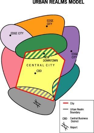
8 business park). A term for the specialization of regional centers would a node. There is no clear CBD in this type of model. The distant decay theory is still applicable to this model. Land value and population density decline with distance from the central places. Difference among Concentric, Sector and Multiple nuclei models 1. monocentric concentric, sector model; polycentric multiple nuclei 2. multiple nuclei more complex in term of land use zones, e.g. industrial suburbs 3. multiple nuclei allows the suburbanization, transport development, outward growth of city 4. multiple nuclei model gives the idea of land use pattern of a city only Criticisms about the Multiple nuclei model 1. Negligence of height of buildings. 2. Non-existence of abrupt divisions between zones. 3. Each zone displays a significant degree of internal heterogeneity and not homogeneity. 4. Unawareness of inertia forces. 5. No consideration of influence of physical relief and government policy. 6. The concepts may not be totally applicable to oriental cities with different cultural, economic and political backgrounds. Urban Realms Model By: Lewis Historical Society Urban Realms Model Each realm is a separate economic, social and political entity that is linked together to form a larger metro framework. Main issue to note with this model is that the city has been decentralized and that edge cities are now the center of realms which surround the city. The main CBD is no longer as influential as it once was. Know what an edge city is to fully understand this model. The creator of the theory of urban realms was James E. Vance Jr., and he created it in the 1960 s. Now urban realms have become, so large they even have exurbs, not just suburbs. Exurbs are suburbs that are, so far away from a city they really can t be called suburbs any more. The model works extremely well wit the San Francisco Bay area, because it is where Vance came up with the model for it. The city this worst applies to is to Phoenix, Arizona, because the city just sprawls, with very bad development, and shows a lot of characteristics of urban sprawl. a. Vance developed the urban realms model from his observation of the San Francisco Bay area and its sprawling metropolis.

9 b. This model includes independent suburban downtowns as their foci, and yet they are within the sphere of influence of the central city and its metropolitan CBD. c. Each urban realm depends on four factors: i. The overall size of the metropolitan region ii. The amount of economic activity in each urban realm iii. The topography and major land features, which help to identify each realm iv. The internal accessibility of each realm for daily economic functions and travel patterns. d. An urban realm is likely to become self-sufficient if: i. The size of the overall metropolis is large ii. There is a large amount of decentralized economic activity in the region iii. Topography barriers isolate the suburban region iv. Good internal accessibility for daily commercial and business travel exists (especially to airport) Latin American City Model //Griffin -Ford Model By: Colleen Baker-Johnson 1. Commercial 2. Elite Residential Sector 3. Middle-class Residential 4. Zone of situ accretion 5. Zone of maturity 6. Gentrification 7. Zone of peripheral squatter settlements General Definition: The Latin American City Model combines elements of Latin American Culture and globalization by combining radial sectors and concentric zones. Includes a thriving CBD with a commercial spine. The quality of houses decreases as one moves outward away from the CBD, and the areas of worse housing occurs in the disamenity sectors. Different aspects of the model: Commercial/CBD: The focus of employment, entertainment, and economic activity; Roads, trains, and buses are fairly reliable here. Market: - informal economy - primitive form of capitalism; beyond control/taxation of gov't; unlicensed people sell homemade goods and services; may or may not be illegal. - formal economy - taxed and licensed by the government Industrial Elite residential sector: The elite sector forms on either side of a narrow spine that contains amenities attractive to the wealthy, such as water and electricity, as well as offices, shops, restaurants, etc. Zone of maturity: Residential area in which a stable population has gradually transformed the district into one that is fully serviced. Zone of in situ accretion: A mix of middle and low income housing, generally thought of as a transitional area (moving either up on down). Zone of peripheral squatter settlements/periferico: Home for impoverished and unskilled; housing consists of
10 mostly shantytowns. Lawless barrios /favelas and is usually behind a main ring highway known as a periferico. Gentrification: A process of converting an urban neighborhood from a predominantly low income renter-occupied area to a predominantly middle to upper-middle class owner-occupied area. Disamenity: Contains relatively unchanging slums (barrios or favelas) that may not be connected to regular city services. Outside the CBD, the dominant component is a commercial spine surrounded by the elite residential sector These two zones are interrelated and called the spine/sector Essentially an extension of the CBD down a major boulevard Here are the city s important amenities parks, theaters, restaurants, and even golf courses Strict zoning and land controls ensure continuation of these activities, protecting elite from incursions by low-income squatters - Note: zoning does not usually occur in these cities excepting in the elite areas Inner-city zone of maturity Less prestigious collection of traditional colonial homes and upgraded self-built homes Homes occupied by people unable to participate in the spine/sector Area of upward mobility - parts of it may be gentrifying Zone of accretion Diverse collection of housing types, sizes, and quality Transition between zone of maturity and next zone Area of ongoing construction and change Some neighborhoods have city-provided utilities Other blocks must rely on water and butane delivery trucks for essential services Zone of peripheral squatter settlements Where most recent migrants are found Fringe contrasts with affluent and comfortable suburbs that ring North American cities Houses often built from scavenged materials Gives the appearance of a refugee camp Surrounded by landscape bare of vegetation that was cut for fuel and building materials Streets unpaved, open trenches carry wastes, residents carry water from long distances, electricity is often pirated Residents who work have a long commute Many are transformed through time into permanent neighborhoods Note: This model makes sense when you think about it. -The larger poor areas reflect the influx of intraregional migrants (rural moving to urban areas) -The industry in the city and even entering into the city to the core reflects the economic strength of many of these peripheral countries that now take on industrial work. -the gentrification and middle class areas as well as the elite reflect an economy that is improving or allowing some to rise up (not what we see in the African City Model). -Industry is on the opposite side of the elite -the middle class are next to the elite separating them from the poor -disamenity can reach all the way to the core but tends to stick to the outside -gentrification is more likely near the CBD and elite area -model created by Griffin and Ford and sometimes called that (Griffin-Ford Model) -Physical geography could also influence the distribution of classes like in Rio, where residents were attracted to the neighborhoods that had nice views of the Atlantic Ocean and beaches.

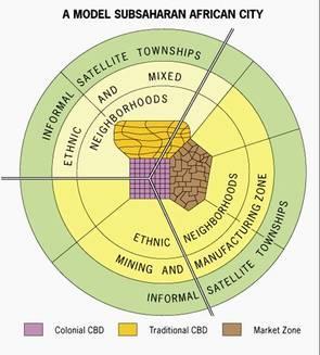
11 African City Model FV By: System Administrator The Sub-Saharan? African City Model is also called the De Blij Model because De Blij, a famous geographer, created this. The tropics of Africa remain under forty percent urbanized and outside this area, the remaining regions are about fifty-seven percent urban. Africa has the world s fastest growing cities, and the impact that European Colonialism has had is clearly evident. The Europeans created prominent urban centers including ports along the coast. Africa also has certain cities that are neither traditional nor colonial such as South Africa s major urban centers that are mostly Western, with elements of European and American models, including highrise central business districts and suburbs. Due to the diversity of its cities, it is complicated to develop an African City Model. The central city is found to have three central business districts (CBDs): a remnant of the colonial CBD, an informal and periodic market zone, and a transitional business center where commerce happens from the curbside or storefronts. The former colonial CBD has vertical development, the traditional business center is usually a zone of single-story buildings with a touch of traditional architecture, and the market zone is open-air, informal (economically), and yet important. Sector development is the encircling zone of ethnic and mixed neighborhoods, in which people have strong ethnic identities. Mining and manufacturing zones are found next to some parts of these ethnic neighborhoods. On the outermost part of many African cities, there are informal satellite townships, which are squatter settlements. These squatter settlements consist of poor neighborhoods, or shantytowns, in which people make home anywhere that is possible or open, no matter if it is public or private. Note: -this reflects the nature of Africa's development. Of the three CBDs, the colonial reflects the past -the mining and manufacturing areas reflect the nature ofthe types of jobs found in African cities -the lack of an mentioned areas of elite, middle-class and gentrification tells something as well -the small colonial CBD reflects a lack of development since that is the area of the formal economy and TNCs (transnational corps) -the ethnic hoods reflect the tribalism that exists -the informal satellite townships means the poor who have moved in close to the city -the lack of any other class getting mentioned reflects the poverty of the area

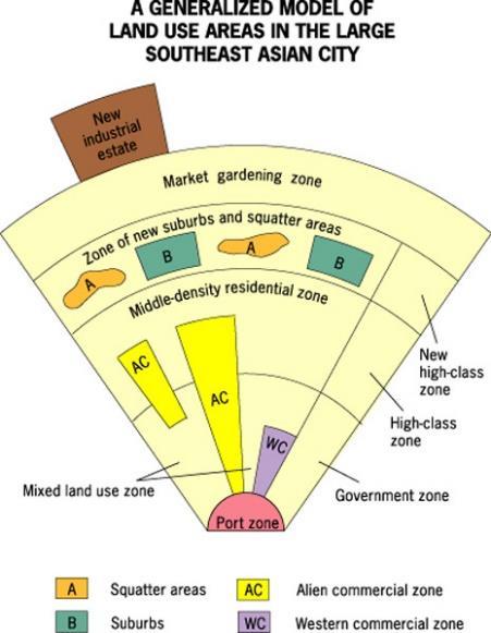
12 Southeast Asian City Model (McGee Model) By: Sarah Bannon Background- Southeast Asia contains some of the most populous and fastest growing cities in the world. While they are still developing, many feature high-rise developments and several of the world s tallest buildings. -This model was developed in 1967 by T.G. McGee. It is sometimes called the McGee Model. McGee studied several cities in Southeast Asia and discovered that they shared certain aspects of land-use. Some similarities include: Old colonial port zone surrounded by a commercial business district Western commercial zone (dominated by Chinese merchants) No formal central business district (CBD) Hybrid sectors & zones growing rapidly New Industrial parks on the outskirts of the city - As the model shows, no CBD is visible. However, several components of the CBD are present in separate areas in the city. Basically the components of the CBD are clustered around the port zone. The Western commercial zone for western businesses. The alien commercial zone is dominated by the Chinese who have migrated to other parts of Asia and live in the same buildings as their businesses. These are Chinese merchants. And then there is the mixed land-use zone that has miscellaneous activities including light industry. There is also a separate area known as the government zone near the center of the model. Also note the mixed- land use zone contains various economic uses which can include informal business. -The focal point is the Port Zone reflecting a city oriented around exporting. Key Concepts: -The Southeast Asian City Model is similar to the Latin American (Griffin-Ford) City Model in that they each feature high-class residential zones that stem from the center, middle-class residential zones that occur in inner-city areas, and low-income squatter settlements that occur in the periphery. - The main difference between the two models is that the Southeast Asian City Model features middle-income housing in suburban areas. This reflects the larger percentage of middle-class citizens that reside in the peripheral regions than those of Latin America. This may reflect a smaller MC in Latin-American cities by comparison. -Due to the alien commercial zone these cities also experience a blended culture but also strong ethnic ties. Where it applies: Many of the medium-sized cities in Southeast Asia have the strongest similarities. Since these cities are developing

13 rapidly, aspects of the city are subject to change. However, as the city continues to develop, it is likely that the middle-class region will expand. It is also important to note that the Southeast Asian City model does not explain why the areas were formed but rather points out trends and patterns. Examples of the model: Kuala Lampur, Malaysia Jakarta, Indonesia Gravity Model By: Sugrue and Wilcek on: Mon 26 of April, :28 CDT (11687 Reads) Gravity Model Wiki The Gravity Model holds that the potential use of a service at a particular location is directly related to the number of people in a location and inversely related to the distance people must travel to reach the service. Main Points Right Here According to the Gravity Model, consumer behavior reflects two patterns: 1.The greater the number of people living in a particular place, the greater is the number of potential customers for a service. A city block or apartment building that contains 100 families will generate more customers than a house containing only one family. 2.The farther people are from a particular service, the less likely they are to use it. People who live 1 kilometer from a store are more likely to patronize it than people who live 10 kilometer away. In other words, cities, countries or regions or other things that have higher numbers of people and are close together are more likely to interact Small cities or countries with low populations that are further away are less likely to interact. So China and the US interact because, even though they are further apart, they are both large The US has perhaps the most interaction with Mexico because both countries are large and close together Whereas Nepal probably does not interact with Paraguay as they are both small and far away. You do this same thing with big and small cities Best Location in a Nonlinear Settlement -Most settlements are more complex than a single main street. Geographers still apply the gravity model to find the best location, following these steps: 1.Identify a possible site for a new service. 2.Within the range of the service, identify where every potential user lives.
14 3.Measure the distance from the possible site of the new service to every potential user. 4.Divide each potential user by the distance to the potential site for the service. 5.Sum all of the results of potential users divided by distances. 6.Select a second possible location for the new service, and repeat steps 2, 3, 4, and 5. 7.Compare the results of step 5 for all possible sites. The site with the highest score has the highest potential number of users and is therefore the optimal location for the service. While the gravity model was created to anticipate migration between cities (and we can expect that more people migrate between LA and NYC than between El Paso and Tucson), it can also be used to anticipate the traffic between two places, the number of telephone calls, the transportation of goods and mail, and other types of movement between places. The gravity model can also be used to compare the gravitational attraction between two continents, two countries, two states, two counties, or even two neighborhoods within the same city. Opponents of the gravity model explain that it can not be confirmed scientifically, that it's only based on observation. They also state that the gravity model is an unfair method of predicting movement because its biased toward historic ties and toward the largest population centers. Thus, it can be used to perpetuate the status quo. The Gravity Model, based off of Newton s Law of Gravity, is used to measure the movement of ideas and people between two places. In this model distance between two areas and their population sizes are taken into consideration. There is a general formula used when determining the gravitational pull a city has. Population of area 1 x Population of area 2 Distance^2 Things such as employment, wages, settlement locations, traffic, trade, migration, and other ideas can be discovered using this model. A downside and often criticism of this model is that there technically is no theoretical support, it is merely an observation. Reilly s Law of Retail Gravitation is a variation of this theory/model. Reilly used this model in order to establish the hinterland around a city. For example, the hinterland of two cities of the same size would have a trade area boundary exactly in the middle of each city. In other cases, the smaller the city, the closer the hinterland. The boundary between both cities is known as the breaking point. At this point, half of the populations shop in either city. Faults related to this model, as with many others, are its assumptions. Reilly s assumptions include a land void of any geographical variances, consumer preferences; political boundaries that effect an individuals progress towards a city. Distance decay is directly relatable to this model and law. Distance decay states that the further away two cities or ideas are, the less likely they are to interact and move.
c. What is the most distinctive above ground result of high land costs and intensive land use? i. Describe the vertical geography of a skyscraper?
 AP Human Geography Unit 7b Guided Reading: Urban Patterns and Social Issues Mr. Stepek Key Issue #1: Why Do Services Cluster Downtown? (Rubenstein p 404 410) 1. What is the CBD? What does it contain and
MULTIPLE CHOICE. Choose the one alternative that best completes the statement or answers the question.
 AP Test 13 Review Name MULTIPLE CHOICE. Choose the one alternative that best completes the statement or answers the question. 1) Compared to the United States, poor families in European cities are more
Urban Geography Unit Test (Version B)
") Urban Geography Unit Test (Version B) 1. What function do the majority of the world s ten most populated cities serve? a. a fortress city to resist foreign invasion b. a port city for transporting people
Urban Geography Unit Test (Version B) 1. What function do the majority of the world s ten most populated cities serve? a. a fortress city to resist foreign invasion b. a port city for transporting people
Problems In Large Cities
 Chapter 11 Problems In Large Cities Create a list of at least 10 problems that exist in large cities. Consider problems that you have read about in this and other chapters and/or experienced yourself.
Chapter 12. Key Issue Two: Why are consumer services distributed in a regular pattern?
 Chapter 12 Key Issue Two: Why are consumer services distributed in a regular pattern? Distribution of Consumer Services Central place theory Market area of a service Size of market area Market area analysis
Chapter 9 Urban Geography (Making questions from notes)
") Chapter 9 Urban Geography (Making questions from notes) Remember that you book is laid out rather neatly in that it divides sections of the chapter into Key Questions. What you want to do is make up questions
Chapter 9 Urban Geography (Making questions from notes) Remember that you book is laid out rather neatly in that it divides sections of the chapter into Key Questions. What you want to do is make up questions
Key Issue 1: Where Are Services Distributed? INTRODUCING SERVICES AND SETTLEMENTS LEARNING OUTCOME DESCRIBE THE THREE TYPES OF SERVICES
 Revised 2017 NAME: PERIOD: Rubenstein: The Cultural Landscape (12 th edition) Chapter Twelve Services and Settlements (pages 430 thru 457) This is the primary means by which you will be taking notes this
22 cities with at least 10 million people See map for cities with red dots
 22 cities with at least 10 million people See map for cities with red dots Seven of these are in LDC s, more in future Fastest growing, high natural increase rates, loss of farming jobs and resulting migration
accessibility accessibility by-pass bid-rent curve bridging point administrative centre How easy or difficult a place is to reach.
 accessibility accessibility How easy or difficult a place is to reach. How easy or difficult it is to enter a building. administrative centre bid-rent curve The function of a town which is a centre for
Key Issue 1: Why Do Services Cluster Downtown?
 Key Issue 1: Why Do Services Cluster Downtown? Pages 460-465 1. Define the term CBD in one word. 2. List four characteristics of a typical CBD. Using your knowledge of services from chapter 12, define
Key Issue 1: Why Do Services Cluster Downtown?
 Key Issue 1: Why Do Services Cluster Downtown? Pages 460-465 ***Always keep your key term packet out whenever you take notes from Rubenstein. As the terms come up in the text, think through the significance
Chapter 12: Services
 Chapter 12: Services The Cultural Landscape: An Introduction to Human Geography Services Service = any activity that fulfills a human want or need Services are located in settlements Location of services
Chapter 12. Services
 Chapter 12 Services Where di services originate? Key Issue #1 Shoppers in Salzburg, Austria Origins & Types of Services Types of services Consumer services Business services Public services Changes in
Services includes: Intro to Services Central Place Theory Urban Hierarchies
 Services includes: Intro to Services Central Place Theory Urban Hierarchies Introduction Services any activity that fulfills human wants/needs Services are located in settlements therefore our study of
Growth of Urban Areas. Urban Hierarchies
 Growth of Urban Areas Urban Hierarchies Directions: In your notebook, complete the following on the right: Create a chart to explain and analyze the gravity model, central place theory, bid-rent theory,
URBAN GEOGRAPHY. Chapter 9
 URBAN GEOGRAPHY Chapter 9 When and Why Did People Start Living in Cities? City: A conglomeration of people and buildings clustered together to serve as a center of politics, culture, and economics Urban:
Contemporary Human Geography 3 rd Edition
 Chapter 13 Lecture Contemporary Human Geography 3 rd Edition Chapter 13: Urban Patterns Marc Healy Elgin Community College 13.1 The Central Business District The best-known and most visually distinctive
Contemporary Human Geography 3 rd Edition
 Contemporary Human Geography 3 rd Edition Chapter 13: Urban Patterns Marc Healy Elgin Community College Services are attracted to the Central Business District (CBD) because of A. accessibility. B. rivers.
Chapter 9: Urban Geography
 Chapter 9: Urban Geography The Five Steps to Chapter Success Step 1: Read the Chapter Summary below, preview the Key Questions, and Geographic Concepts. Step 2: Complete the Pre-Reading Activity (PRA)
Human Geography. Urban Development. Urban Development. Urban Development. Unit 8: Urban Development. I. Why are Settlements Established?
 I. Why are Settlements Established? A. Rural Settlements B. Urban Settlements Human Geography Unit 8: I. Why are Settlements Established? C. REASONS FOR ESTABLLISHING SETTLEMENTS 1. Cultural Religious
The Cultural Landscape Eleventh Edition
 Chapter 13 Lecture The Cultural Landscape Eleventh Edition Urban Patterns Matthew Cartlidge University of Nebraska-Lincoln Key Issues Why do services cluster downtown? Where are people distributed within
Services By Eugene Stanton
 Chapter 12 Services By Eugene Stanton Services The regular distribution (of settlements) observed over North America and over other more developed countries is not seen in less developed countries. The
C) Discuss two factors that are contributing to the rapid geographical shifts in urbanization on a global scale.
 Discuss two factors that are contributing to the rapid geographical shifts in urbanization on a global scale.") AP Human Geography Unit VII. Cities and Urban Land Use Free Response Questions FRQ 1 Rapid urbanization in Least Developed Countries (LDCs) has many profound impacts for the world. Answer the following
AP Human Geography Unit VII. Cities and Urban Land Use Free Response Questions FRQ 1 Rapid urbanization in Least Developed Countries (LDCs) has many profound impacts for the world. Answer the following
AP Human Geography Free-response Questions
 AP Human Geography Free-response Questions 2000-2010 2000-preliminary test 1. A student concludes from maps of world languages and religions that Western Europe has greater cultural diversity than the
Background the Ch. 12
 Ch. 12 -Services Background the Ch. 12 Shopping Mall Sydney, Australia Services: an activity that provides a human want or need in exchange for money Settlement: permanent collection of buildings where
pg 273 -In studying the size of cities and distances between them, urban geographers explored the trade areas of different size cities -trade areas
 pg 273 -In studying the size of cities and distances between them, urban geographers explored the trade areas of different size cities -trade areas the adjacent region to every city and town within which
Unit 7. Cities and Urban Land Use
 Unit 7 Cities and Urban Land Use Define Urbanism Population Depends on the Location Portugal Ethiopia Norway Define Urbanism Metropolitan Statistical Area Census Central City Immediate Interacting Communities
Edexcel Geography Advanced Paper 2
 Edexcel Geography Advanced Paper 2 SECTION B: SHAPING PLACES Assessment objectives AO1 Demonstrate knowledge and understanding of places, environments, concepts, processes, interactions and change, at
Rural Gentrification: Middle Class Migration from Urban to Rural Areas. Sevinç Bahar YENIGÜL
 'New Ideas and New Generations of Regional Policy in Eastern Europe' International Conference 7-8 th of April 2016, Pecs, Hungary Rural Gentrification: Middle Class Migration from Urban to Rural Areas
Unit 8 Settlement Geography: Urban and Rural, Cities and City Life
 Unit 8 Settlement Geography: Urban and Rural, Cities and City Life 38:180 Human Geography Settlement Geography Principally urban, but a continuum: Hamlet Village Town City plus rural World is predominantly
2. What is a settlement? Why do services cluster in settlements?
 Chapter 12: Services Introduction and Case Study (p. 397-399) 1. What is a service? How do LDCs and MDCs differ in regards to the number of workers employed in service- sector jobs? 2. What is a settlement?
It is clearly necessary to introduce some of the difficulties of defining rural and
 UNIT 2 CHANGING HUMAN ENVIRONMENTS G2 Theme 2 Investigating Settlement Change in MEDCs 2.1 What are the distinctive features of settlements? It is clearly necessary to introduce some of the difficulties
Curriculum Unit. Instructional Unit #1
 Curriculum Unit Name of Course: AP Human Geography Grade Level(s): 9-12 Brief Description (Course Catalog): The purpose of the AP Human Geography course is to introduce students to the systematic study
Community Development, Economic Development, or Community Economic Development? Concepts, Tools and Practices
 Community Development, Economic Development, or Community Economic Development? Concepts, Tools and Practices Location Theory: Part I Location theory helps us one basic question: why does economic activity
Too Close for Comfort
 Too Close for Comfort Overview South Carolina consists of urban, suburban, and rural communities. Students will utilize maps to label and describe the different land use classifications. Connection to
TYPES OF GOVERNMENTS
 While the terms country, state, and nation are often used interchangeably, there is a difference. A State (note the capital "S") is a self-governing political entity. The term State can be used interchangeably
Cheat Sheets Law of the sea: -Territorial sea: -EEZ (Exclusive Economic Zone): -Median-line principle:
: -Median-line principle:") Cheat Sheets I in no way guarantee these as FRQs. As predicted by OTHER AP HUG TEACHERS (WHO HAVE BEEN TEACHING LONGER THAN ME), these are possibly FRQs; either way, they reinforce concepts studied. UN
Cheat Sheets I in no way guarantee these as FRQs. As predicted by OTHER AP HUG TEACHERS (WHO HAVE BEEN TEACHING LONGER THAN ME), these are possibly FRQs; either way, they reinforce concepts studied. UN
MEGALOPOLIS. Megalopolis at Night. Megalopolis. LANDSCAPES of Megalopolis 3/7/2013
 MEGALOPOLIS Regional Landscapes of the United States and Canada MEGALOPOLIS Prof. Anthony Grande AFG 2013 Term used to describe any large urban area created by the growth toward each other and eventual
The Spatial Structure of Cities: International Examples of the Interaction of Government, Topography and Markets
 Module 2: Spatial Analysis and Urban Land Planning The Spatial Structure of Cities: International Examples of the Interaction of Government, Topography and Markets Alain Bertaud Urbanist Summary What are
Economics 312: Urban Land Economics University of Victoria Midterm Examination #1 VERSION 1 SOLUTIONS Spring 2018 Instructor: Martin Farnham
 Economics 312: Urban Land Economics University of Victoria Midterm Examination #1 VERSION 1 SOLUTIONS Spring 2018 Instructor: Martin Farnham Midterm Exam #1 Section 1: Multiple Choice (2 points each) Unless
Name Date Period Barron s (6 th edition) Chapter 7 Urban Geography
 Chapter 7 Urban Geography") Name Date Period Barron s (6 th edition) Chapter 7 Urban Geography Historical Geography of Urban Environments 1. In what way did the development of different types of occupations (carpenters, merchants,
Name Date Period Barron s (6 th edition) Chapter 7 Urban Geography Historical Geography of Urban Environments 1. In what way did the development of different types of occupations (carpenters, merchants,
AP Human Geography Unit 7a: Services Guided Reading Mr. Stepek Introduction (Rubenstein p ) 1. What is the tertiary sector of the economy?
 1. What is the tertiary sector of the economy?") Public Business Consumer AP Human Geography Unit 7a: Services Guided Reading Mr. Stepek Introduction (Rubenstein p 372 374) 1. What is the tertiary sector of the economy? 2. What is a service activity?
Public Business Consumer AP Human Geography Unit 7a: Services Guided Reading Mr. Stepek Introduction (Rubenstein p 372 374) 1. What is the tertiary sector of the economy? 2. What is a service activity?
VII. Cities and Urban Land Use
 VII. Cities and Urban Land Use Tuesday, May 2, 2017 8:13 AM Enduring Understandings Learning Objectives Essential Knowledge A. The form, function, and size of urban settlements are constantly changing
Subject: Note on spatial issues in Urban South Africa From: Alain Bertaud Date: Oct 7, A. Spatial issues
 Page 1 of 6 Subject: Note on spatial issues in Urban South Africa From: Alain Bertaud Date: Oct 7, 2009 A. Spatial issues 1. Spatial issues and the South African economy Spatial concentration of economic
Urban Foundations. Early American Cities. Early American Cities. Early American Cities. Cities in America to 1945
 Urban Foundations Cities in America to 1945 Early American Cities The design of early American cities was highly influenced by European traditions The roots of many of these traditions can in turn be traced
AP Human Geography Models & Theories (not necessarily comprehensive! 1. Demographic Transition Model. 2. Gravity Model
 AP Human Geography Models & Theories (not necessarily comprehensive 1. Demographic Transition Model 2. Gravity Model 3. Zelinsky (perceptual regions) Zelinsky was student of Carl Sauer; a cultural geographer
HSC Geography. Year 2013 Mark Pages 10 Published Jul 4, Urban Dynamics. By James (97.9 ATAR)
") HSC Geography Year 2013 Mark 92.00 Pages 10 Published Jul 4, 2017 Urban Dynamics By James (97.9 ATAR) Powered by TCPDF (www.tcpdf.org) Your notes author, James. James achieved an ATAR of 97.9 in 2013 while
HSC Geography Year 2013 Mark 92.00 Pages 10 Published Jul 4, 2017 Urban Dynamics By James (97.9 ATAR) Powered by TCPDF (www.tcpdf.org) Your notes author, James. James achieved an ATAR of 97.9 in 2013 while
Chapter 12. Key Issue Three: Why do business services locate in large settlements?
 Chapter 12 Key Issue Three: Why do business services locate in large settlements? Business Services and Settlements World cities Ancient world cities Medieval world cities Modern world cities Hierarchy
UC Santa Barbara CSISS Classics
 UC Santa Barbara CSISS Classics Title Walter Christaller, Hierarchical Patterns of Urbanization. CSISS Classics Permalink https://escholarship.org/uc/item/6188p69v Author Agarwal, Pragya Publication Date
g. Sanger h. Denton i. Lewisville j. Dallas k. Prosper l. Frisco 2. What patterns can you identify as you study the places you located on the map?
 IR-15: Texas Cities 1. Use a Texas highway map as a reference to locate and mark the following cities on the outline map below: a. Anahuac b. Baytown c. Pasadena d. Houston e. Katy f. Brookshire g. Sanger
Social Studies Grade 2 - Building a Society
 Social Studies Grade 2 - Building a Society Description The second grade curriculum provides students with a broad view of the political units around them, specifically their town, state, and country.
Ch. 13: Urban Patterns
 Ch. 13: Urban Patterns Name: Introduction & Case Study (p. 430-432) 1. Describe some differences between urban and rural environments. 2. Why do MDCs have a higher percentage of people living in urban
Factors Affecting Human Settlement
 Factors Affecting Human Settlement Physical Factors One of the most basic factors affecting settlement patterns is the physical geography of the land. Climate is key, because if a place is too dry, too
Key Issue 1: Where Is Industry Distributed?
 Key Issue 1: Where Is Industry Distributed? Pages 395-397 ***Always keep your key term packet out whenever you take notes from Rubenstein. As the terms come up in the text, think through the significance
Chapter 13: Urban Patterns The Cultural Landscape:
 Chapter 13: Urban Patterns The Cultural Landscape: An Introduction to Human Geography Key Issues Why do services cluster downtown? Where are people distributed within urban areas? Why are urban areas expanding?
LOUISIANA STUDENT STANDARDS FOR SOCIAL STUDIES THAT CORRELATE WITH A FIELD TRIP TO DESTREHAN PLANTATION KINDERGARTEN
 LOUISIANA STUDENT STANDARDS FOR SOCIAL STUDIES THAT CORRELATE WITH A FIELD TRIP TO DESTREHAN PLANTATION KINDERGARTEN Standard 2 Historical Thinking Skills Students distinguish between events, people, and
Understanding and Measuring Urban Expansion
 VOLUME 1: AREAS AND DENSITIES 21 CHAPTER 3 Understanding and Measuring Urban Expansion THE CLASSIFICATION OF SATELLITE IMAGERY The maps of the urban extent of cities in the global sample were created using
Your web browser (Safari 7) is out of date. For more security, comfort and the best experience on this site: Update your browser Ignore
 is out of date. For more security, comfort and the best experience on this site: Update your browser Ignore") Your web browser (Safari 7) is out of date. For more security, comfort and the best experience on this site: Update your browser Ignore urban area For the complete encyclopedic entry with media resources,
Your web browser (Safari 7) is out of date. For more security, comfort and the best experience on this site: Update your browser Ignore urban area For the complete encyclopedic entry with media resources,
R E SEARCH HIGHLIGHTS
 Canada Research Chair in Urban Change and Adaptation R E SEARCH HIGHLIGHTS Research Highlight No.8 November 2006 THE IMPACT OF ECONOMIC RESTRUCTURING ON INNER CITY WINNIPEG Introduction This research highlight
AP HUMAN GEOGRAPHY REVIEW. Models and Theories NAME
 AP HUMAN GEOGRAPHY REVIEW Models and Theories NAME 1 Distance Decay Sometimes called friction of distance Main Idea: Interaction between two places decreases as distance increases Example #1: The person
AP Human Geography AP EXAM Free Response Questions and Possible Future Questions
 AP Human Geography AP EXAM Free Response Questions and Possible Future Questions FRQ Exam Questions: Population & Migration 2003- European Migration and Demographic Transition Model 2004- Population Pyramids
Cities, Countries, and Population
 Cities, Countries, and Population After the world industrialized, better food, improved sanitation, and new medicines caused the world population to soar. To understand how heavily populated an area is,
Chapter 3A: North America Realm
 Geography: Realms, Regions and Concepts 15 th Edition By de Blij and Muller Chapter 3A: North America Realm Population Clusters Both have highly urbanized populations High degree of cultural pluralism,
Economic Geography of the Long Island Region
 Geography of Data Economic Geography of the Long Island Region Copyright 2011 AFG 1 The geography of economic activity requires: - the gathering of spatial data - the location of data geographically -
Simple Solutions Social Studies Level 2. Level 2. Social Studies. Help Pages
 Level 2 Social Studies 147 148 adobe houses with bricks made of clay and straw ancestor a family member who lived before us appoint choose; leaders can appoint others barter trading one thing for another
Urban Economics City Size
 Urban Economics City Size Utility and City Size Question: Why do cities differ in size and scope? While NYC has a population of more 18 million, the smallest urban area in the U.S. has only 13,000. A well
A Shift to the Sunbelt
 Adam Giladi 4/1/13 A Shift to the Sunbelt The changing global economy has lead to an increased interconnection between nations and the mass movement of individuals from one area to another. This movement
MARS AREA SCHOOL DISTRICT CURRICULUM GRADE: Grade 4
 MARS AREA SCHOOL DISTRICT CURRICULUM GRADE: Grade 4 Course Title: Social Studies Brief Description Overview: Students will explore the history, geography, government, and economy of the United States with
The Trade Area Analysis Model
 The Trade Area Analysis Model Trade area analysis models encompass a variety of techniques designed to generate trade areas around stores or other services based on the probability of an individual patronizing
Spatial profile of three South African cities
 Spatial Outcomes Workshop South African Reserve Bank Conference Centre Pretoria September 29-30, 2009 Spatial profile of three South African cities by Alain Bertaud September 29 Email: duatreb@msn.com
10/23/2017. Week 6. Retail and the Settlement Pattern. Whataburger Locations. A family-owned quick service restaurant chain
 Schedule Updates and Reminders Here are some important dates and items from our class schedule over the next few weeks: Mon, Oct 23: Commerce and the Settlement Pattern Wed, Oct 25: Talk by Amanda Regan
São Paulo Metropolis and Macrometropolis - territories and dynamics of a recent urban transition
 São Paulo Metropolis and Macrometropolis - territories and dynamics of a recent urban transition Faculty of Architecture and Urbanism of São Paulo University Prof. Dr. Regina M. Prosperi Meyer WC2 - World
Cultural Diffusion. AP HG SRMHS Mr. Hensley
 Cultural Diffusion AP HG SRMHS Mr. Hensley Space-time compression: The reduction in time it takes for something to reach another place Because of technology, connections have reduced distance (not literally
Socials Studies. Chapter 3 Canada s People 3.0-Human Geography
 Socials Studies Chapter 3 Canada s People 3.0-Human Geography Physical Geography Study of the natural features of the Earth s surface including landforms, climate, ocean currents and flora and fauna Human
Note on Transportation and Urban Spatial Structure
 Note on Transportation and Urban Spatial Structure 1 By Alain Bertaud, Washington, ABCDE conference, April 2002 Email: duatreb@msn.com Web site: http://alain-bertaud.com/ http://alainbertaud.com/ The physical
Social Studies Curriculum Document Grade 3 Alignment with Common Core Unit 1 Student Learning Expectation
 Social Studies Curriculum Document Grade 3 Alignment with Common Core Unit 1 Student Learning Enduring Understanding: Good citizenship should be evident by observing proper etiquette of the American flag.
What s wrong with sprawl? The urgent need for cost benefit analyses of modern urban growth patterns. Jacy Gaige
 What s wrong with sprawl? The urgent need for cost benefit analyses of modern urban growth patterns. Jacy Gaige Urban Econ 245 Professor Charles Becker Literature Review 1 Urban is hip. Bikes, messenger
Urban Planning Word Search Level 1
 Urban Planning Word Search Level 1 B C P U E C O S Y S T E M P A R E U O E U R B A N P L A N N E R T N S T D H E C O U N T Y G E R E R D W R E N I C I T Y C O U N C I L A A A S U G G C I L A G P R I R
Borchert s Epochs of American Urbanization
 Borchert s Epochs of American Urbanization Geographers define cities as intersecting points of communication and transportation. Cities serve multiple social, political, economic and cultural purposes.
Density. These are the four ways to identify a location
 Density The number of objects per unit of land area Unit 1 100 Toponym, Site, Situation, Absolute Location These are the four ways to identify a location Unit 1 200 1 Relocation and Expansion Diffusion
3 rd Grade Social Studies Pacing Guide Arkansas Frameworks
 3 rd Grade Social Studies Pacing Guide Arkansas Frameworks 1st Nine Weeks Strand1: Geography Standard 1: Physical and Spatial Students shall develop an understanding of the physical and spatial characteristics
THEORIES OF URBAN MORPHOLOGY. Component-I(A) - Personal Details Role Name Affiliation
 - Personal Details Role Name Affiliation") THEORIES OF URBAN MORPHOLOGY Component-I(A) - Personal Details Role Name Affiliation Principal Investigator Prof. Masood A Siddiqui Department of Geogra Jam Jamia Millia Islamia, New Delhi Paper Coordinator,
THEORIES OF URBAN MORPHOLOGY Component-I(A) - Personal Details Role Name Affiliation Principal Investigator Prof. Masood A Siddiqui Department of Geogra Jam Jamia Millia Islamia, New Delhi Paper Coordinator,
International Court of Justice World Trade Organization Migration and its affects How & why people change the environment
 Social Issues Unit 2 Population Grade 9 Time for Completion: 12 class period State Standard: The student uses a working knowledge and understanding of the spatial organization of Earth s surface and relationships
Unit 1, Lesson 3 What Tools and Technologies Do Geographers Use?
 Unit 1, Lesson 3 What Tools and Technologies Do Geographers Use? Geographers use a variety of tools and technologies in investigating geographic questions. Maps and globes both represent the earth, but
Urbanization 5/17/2002 1
 Urbanization Study of processes of urbanization in sociology is called urban sociology. Urbanization is the process of increase in the percentage of a population living in cities. A city is a densely settled
How Geography Affects Consumer Behaviour The automobile example
 How Geography Affects Consumer Behaviour The automobile example Murtaza Haider, PhD Chuck Chakrapani, Ph.D. We all know that where a consumer lives influences his or her consumption patterns and behaviours.
Chapter 13 Urban Patterns Pearson Education, Inc.
 Chapter 13 Urban Patterns Urban Patterns: Key Issues 1. Why Are Downtowns Distinctive? 2. Where Are People Distributed in Urban Areas? 3. Why Do Urban Areas Expand? 4. Why Do Cities Face Sustainability
Opportunities and challenges of HCMC in the process of development
 Opportunities and challenges of HCMC in the process of development Lê Văn Thành HIDS HCMC, Sept. 16-17, 2009 Contents The city starting point Achievement and difficulties Development perspective and goals
Discerning sprawl factors of Shiraz city and how to make it livable
 Discerning sprawl factors of Shiraz city and how to make it livable 1. Introduction: Iran territory has now been directly affected by urban land-uses which are shaping landscapes in cities and around them.
Urban White Paper on Tokyo Metropolis 2002
 Urban White Paper on Tokyo Metropolis 2002 By Bureau of City Planning Tokyo Metropolitan Government Part I. "Progress in IT and City Building" Effects of computer networks on cities and cities' response
WORLD REGIONAL GEOGRAPHY. By Brett Lucas
 WORLD REGIONAL GEOGRAPHY By Brett Lucas NORTH AMERICA Part 1 Defining the Realm Population Clusters United States and Canada have highly urbanized populations. Both have high degree of cultural pluralism,
Neighborhood Locations and Amenities
 University of Maryland School of Architecture, Planning and Preservation Fall, 2014 Neighborhood Locations and Amenities Authors: Cole Greene Jacob Johnson Maha Tariq Under the Supervision of: Dr. Chao
Forecasts for the Reston/Dulles Rail Corridor and Route 28 Corridor 2010 to 2050
 George Mason University Center for Regional Analysis Forecasts for the Reston/Dulles Rail Corridor and Route 28 Corridor 21 to 25 Prepared for the Fairfax County Department of Planning and Zoning Lisa
Urban Form and Travel Behavior:
 Urban Form and Travel Behavior: Experience from a Nordic Context! Presentation at the World Symposium on Transport and Land Use Research (WSTLUR), July 28, 2011 in Whistler, Canada! Petter Næss! Professor
AP Human Geography. Additional materials, including case studies, videos, and aerial photos, will be used to supplement primary course materials.
 Course Introduction AP Human Geography is a yearlong college-level course designed to prepare students for the Advanced Placement (AP) Human Geography Exam. The course focuses on the study of human populations
Urban Revival in America
 Urban Revival in America Victor Couture 1 Jessie Handbury 2 1 University of California, Berkeley 2 University of Pennsylvania and NBER May 2016 1 / 23 Objectives 1. Document the recent revival of America
Identifying Megaregions in the US: Implications for Infrastructure Investment
 7. 10. 2 0 08 Identifying Megaregions in the US: Implications for Infrastructure Investment Dr. Myungje Woo Dr. Catherine L. Ross Jason Barringer Harry West Jessica Lynn Harbour Doyle Center for Quality
Employment Decentralization and Commuting in U.S. Metropolitan Areas. Symposium on the Work of Leon Moses
 Employment Decentralization and Commuting in U.S. Metropolitan Areas Alex Anas Professor of Economics University at Buffalo Symposium on the Work of Leon Moses February 7, 2014 9:30-11:15am, and 2:30-4:30pm
Generic Success Criteria
 Generic Success Criteria Significance I can identify a short term and long term impact that a development/event/issue has/had locally/globally. I can discuss (verbally, graphically, etc.) how a development/event/issue
Unit 1, Lesson 2. What is geographic inquiry?
 What is geographic inquiry? Unit 1, Lesson 2 Understanding the way in which social scientists investigate problems will help you conduct your own investigations about problems or issues facing your community