Greetings from ISPRS Council
|
|
|
- Abel Chandler
- 5 years ago
- Views:
Transcription


1 16 th International Surveyors Congress, RISM, June years of serving society with relevant and reliable information from imagery Jon Mills MRICS FCInstCES FHEA ISPRS Treasurer, Professor of Geomatic Engineering Head of School of Civil Engineering & Geosciences Centre for Earth Systems Engineering Research Newcastle University United Kingdom Greetings from ISPRS Council and the entire ISPRS Community 1
2 Overview ISPRS Mission and relevance Challenges Meeting the challenges Collaboration Remaining relevant ISPRS Mission and relevance 2

3 ISPRS is an international NGO with a focus on science and development in photogrammetry, remote sensing, spatial information cooperation between different stake holders academia, private industry, government, end users truly global cooperation education, technology transfer, capacity building ISPRS A global society of organisations 3

4 Visitors to ISPRS webpage ISPRS mission: why we exist to advance the photogrammetry, remote sensing and spatial information sciences through international cooperation in research, development and education for the benefit of society and for environmental sustainability. (from ISPRS Strategic Plan 2010) 4
5 ISPRS: beyond photogrammetry Today, ISPRS activities include acquisition, modelling, analysis, database management and visualisation of geospatial data in different applications with a focus on imagery: Information from Imagery Relevance of information from imagery Sustainable development Urban and rural, mega cities, energy, Environmental monitoring Global warming, sea level rise, Disaster mapping and monitoring Wenchun Earthquake, China 2008, Autonomous driving and navigation Mobility, safety, Homeland security, 5
6 ISPRS activities Stimulate formation of national or regional Societies of Photogrammetry, Remote Sensing and Spatial Information Science Initiate and coordinate research in these areas Hold international Symposia and Congresses at regular intervals Ensure worldwide circulation of records of discussion and results of research by publication Promote cooperation and coordination with related international scientific organizations ISPRS Challenges 6
7 Challenges: society, policy, industry ICT development, internet time I want it NOW, 24/7 open source, open data, open standards Need for global geospatial information rapid response to key global challenges climate change, disaster management, peace and security, environmental quality, demographic change, migration, Changing roles of governments lean state: from producer to clearing house relaxed resolution restrictions consequences of financial crisis in many countries Challenges: society, policy, industry Changes in the commercial sector new big players: Google, Microsoft, Oracle, fusion of formerly independent companies growing capability in GIS development and LBS production in countries with low wages Need for coordination of GI management among countries and commercial companies between countries and internat. organizations spatial is not special any more 7
8 Challenges: society, policy, industry standardization, interoperability and sharing of data and services by overcoming legal and institutional barriers best practices of geospatial information management compilation and dissemination effective strategies for capacity building for management of geospatial information especially in developing countries Challenges: research & development better sensors, new sensors, sensor combinations nadir and oblique aerial images ever improving resolution of space images image sequences for monitoring dynamic scenes varying sensor geometry (lines, panorama, fish eye,...) 3D cameras, full waveform lasers, texture projectors,... image databases, the web (in part for crowd sourcing) sensor combinations, e. g. mobile mapping multiple cooperative sensors, geosensor networks non-conventional platforms: UAV, mobile mapping,... 8
9 Challenges: research & development full 3D, needing data fusion, e.g. airborne + terrestrial change monitoring, database update, prediction real-time processing(navigation, driver assistance, traffic monitoring, safety and security applications, ) distributed processing (speed, integrity, scalability) crowd sourcing: new mechanisms for trust and reliability increased automation(a shear necessity) towards consumer market products (another necessity) embedded photogrammetry connection to CV, CG and game engines ISPRS Meeting the challenges 9


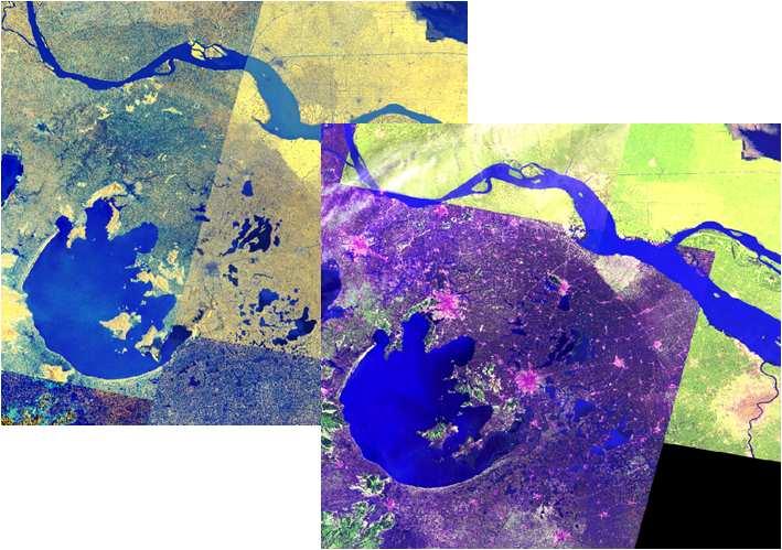
10 Climate change Dr R K Pachauri: IPCC REPORT Global change GlobalLand 30: 2010 National Geomatics Center of China 10


11 30m 1km CESER Research Programme: Integrated systems demonstrations 11


12 Urban resilience Cities focal points of consumption and emissions: 50% global population, ~80% global GHG emissions Cities concentrations of vulnerability to chronic climate stress and extremes: Flooding, heat, air quality etc. Improved tools for urban design and adaption, both today and in the future Urban resilience: heat 12

 11:42 12:25 14:06 London")
 Heatwave Risk 2050s")
13 Daily urban temperature dynamics Diurnal development of London surface temperatures during a day in the 2003 heatwave (AVHRR) 11:42 12:25 14:06 London future spatial heat risk Heatwave Risk Control ( ) Heatwave Risk 2050s (90 th percentile) 13


14 Transport disruption and economic risk Urban resilience: flooding 14


15 Airborne laser scanning data Orthoimagery 15


16 Mobile laser scanning Panoramic imagery 16


17 Combined mobile & airborne laser scanning Flood modelling 17


18 Citizen science Crossing of Coast Road with Benton Road and Chillingham Road. Modelwater depth=1.45m Rothbury Terrace Model water depth= 0.75m Walkergate Model depth=1.36m Chillingham Road Model depth=0.45m Future challenges: developing nations 18


19 Future challenges: developing nations Future challenges: developing nations 19

20 ISPRS Collaboration Collaboration is critical JBGIS The Joint Board of Geospatial Information Societies GSDI, IEEE-GRSS, IAG, ICA, FIG, IGU, IHO, IMTA, ISPRS, ISCGM a coalition of leading international geospatial societies to represent GI societies at international level, in particular within United Nations 20


21 Links to scientific umbrella organisations, UN bodies and other groups Memoranda of Understanding or close relations to ICSU: International Council for Science ICSU GeoUNIONS GEO: Group on Earth Observations OGC: Open Geospatial Consortium UN GGIM: Committee on Global Geospatial Information Management UN OOSA: Office of Outer Space Affairs COPUOS: Committee for Peaceful Uses of Outer Space CEOS: Committee on Earth Observation Satellites IAA: International Academy of Astronautics Outreach and dissemination 21
22 ISPRS Remaining relevant ISPRS vision: where we want to go to be the foremost scientific society in its field and for the Society at large, to speak for all peopleworking in the field, to provide the necessary resources to develop the field. (from ISPRS Strategic Plan 2010) 22
23 Priorities for Strengthen scientific excellence on international level incl. facilitation of publication in high-ranked journals Enhance public recognition of photogrammetry, remote sensing and spatial information science for benefit of humankind and sustainability of environment Increase relevance to members Expand membership of ISPRS in areas where the society is underrepresented Increase cooperation with sister societies in overlapping areas Increase role in education and capacity building in collaboration with international partners Individual membership 23

24 ISPRS publications: professional publishing of proceedings ISPRS structure 24
25 8 Technical Commissions ( ) No. Commission title President I Sensors and platforms for remote sensing Charles Toth (USA) II Theory and concepts of spatial information science Songnian Li (CAN) III Photogrammetric computer vision and image analysis Konrad Schindler (CH) IV Geospatial databases and location based services Jie Jiang (China) V Close-range imaging, analysis and applications Fabio Remondino(Italy) VI Education, technology transfer and capacity building Jianya Gong (China) VII Thematic processing, modeling and analysis of remotely sensed data Filiz Sunar(Turkey) VIII Remote sensing applications and policies Vinay K. Dadhwal(India) Ample cooperation within and across commissions Recent developments Geoinformation market more interesting to ICT community and general public at large stronger competition from other disciplines Number of relevant scientific meetings in ISPRS and beyond has risen Increasing overlap between TCs in particular TC II+IV, TC III+V, TC VII+VIII fragmentation, duplication of effort Interest in becoming WG officer, but less in TC 25

26 Revision of commission structure /www2.isprs.org/news/blog/detail/items/council-exploresrevision-of-isprs-commission-structure.html Aims of restructuring To increase relevance of ISPRS To concentrate the efforts on the most important issues and reduce existing lack of focus in some of our activities To enhance the attractiveness of hosting a TC for Ordinary Members and individuals acting as Technical Commission Presidents To better position ISPRS as a relevant, vibrant, forward-lookingorganisation for 21 st Century 26


 France 28 September - 2 October 2015")
27 A possible new structure 4 (larger) commissions Earth Observation Photogrammetry Spatial Information Science Policies, Education and Outreach A vice president for each commission Preferably from a country different to the TCP ISPRS Geospatial Week, a combination of WS ISPRS GeospatialWeek2015 Bundle of International Conferences Montpellier (La Grande Motte) France 28 September - 2 October


28 ISPRS Midterm Symposia 2014 No. Theme Date Location I Sensors and platforms for remote sensing Nov Denver, US II Theory and concepts of spatial info. Science Oct. 6-8 Toronto, CAN III Photogram. comp. vision a. image analysis Sept. 5-7 Zürich, CH IV Geospatial DB and location based services May Suzhou, China V VI VII Close-range imaging, analysis and applications Education, technology transfer and capacity building Thematic processing, modeling and analysis of remotely sensed data Jun May Sept. 30-Oct. 2 Riva del Garda,ITA Wuhan, China Istanbul, TUR VIII Remote sensing applications and policies Dec Hyderabad, IND XXIII ISPRS Congress, Prague 2016 From human history to the future with spatial information July 12-19, 2016 Due date for abstract submission Autumn
 www.ncl.ac.")
29 ISPRS 104 years of serving society with information from imagery and still going strong Acknowledgements Contributions kindly received from: ISPRS Council Orhan Altan, Chen Jun, Lena Halounova, Christian Heipke, Marguerite Madden Colleagues at Newcastle University Stuart Barr, Richard Dawson, Pauline Miller Centre for Earth Systems Engineering (CESER) Funding bodies 29
ISPRS International Society for Photogrammetry and Remote Sensing. Serving society with information from images
 ISPRS International Society for Photogrammetry and Remote Sensing Serving society with information from images Table of content Mission and vision, legacy Membership Internal structure External relations
XXIII CONGRESS OF ISPRS RESOLUTIONS
 XXIII CONGRESS OF ISPRS RESOLUTIONS General Resolutions Resolution 0: Thanks to the Czech Society commends: To congratulate The Czech Society, its president and the Congress Director Lena Halounová, the
EuroSDR (European Spatial Data Research)
") EuroSDR (European Spatial Data Research) ROLLING RESEARCH PLAN 2015-2018 EuroSDR Secretariat Public Governance Institute KU Leuven Parkstraat 45 bus 3609 3000 Leuven Belgium Tel.: +32 16 32 31 80 Fax:
EuroSDR (European Spatial Data Research) ROLLING RESEARCH PLAN 2015-2018 EuroSDR Secretariat Public Governance Institute KU Leuven Parkstraat 45 bus 3609 3000 Leuven Belgium Tel.: +32 16 32 31 80 Fax:
ISPRS International Society for Photogrammetry and Remote Sensing
 ISPRS International Society for Photogrammetry and Remote Sensing Relevance of Information from Imagery Sustainable development Urban and rural, mega cities, energy, Environmental monitoring Global warming,
Chris Rizos (IAG), Chair William Cartwright (ICA), immediate past Chair
, Chair William Cartwright (ICA), immediate past Chair") Chris Rizos (IAG), Chair William Cartwright (ICA), immediate past Chair Global Spatial Data Infrastructure (GSDI) Association IEEE Geoscience & Remote Sensing Society (IEEE-GRSS) International Association
Chris Rizos (IAG), Chair William Cartwright (ICA), immediate past Chair Global Spatial Data Infrastructure (GSDI) Association IEEE Geoscience & Remote Sensing Society (IEEE-GRSS) International Association
From PCGIAP to UN GGIM AP: A Regional Perspective on GGIM
 Regional Committee of United Nations Global Geospatial Information Management for Asia and the Pacific (UN-GGIM-AP) Established by a United Nations Resolution From PCGIAP to UN GGIM AP: A Regional Perspective
Building Institutional Capacity for Multi-Hazard Early Warning in Asia and the Pacific Subtitle
 Building Institutional Capacity for Multi-Hazard Early Warning in Asia and the Pacific Subtitle Title Keran Wang Chief, Space Applications Section ICT and Disaster Risk Reduction Division 22 May 2018 Pillar
2018/1 The integration of statistical and geospatial information. The Regional Committee of UN-GGIM: Americas:
 The following are the conclusions and recommendations of the Regional Committee of the United Nations on Global Geospatial Information Management for the Americas, during its Fifth Session, Thursday 8
The Third UN-GGIM-AP Plenary Meeting. ICA Report as Liaison Organization of UN-GGIM-AP. Bali Indonesia 10 November 2014
 The Third UN-GGIM-AP Plenary Meeting ICA Report as Liaison Organization of UN-GGIM-AP Bali Indonesia 10 November 2014 Sukendra Martha Vice President International Cartographic Association (ICA) Outline
SDG s and the role of Earth Observation
 SDG s and the role of Earth Observation Christian Heipke IPI - Institute for Photogrammetry and GeoInformation Leibniz Universität Hannover Germany Secretary General, ISPRS 1. No Poverty 2. Zero Hunger
Economic and Social Council
 United Nations Economic and Social Council Distr.: General 18 July 2016 Original: English Committee of Experts on Global Geospatial Information Management Sixth session New York, 3-5 August 2016 Item 2
8th FIG Regional Conference November 2012 Montevideo, Uruguay
 8th FIG Regional Conference 26 29 November 2012 Montevideo, Uruguay Platinum Sponsors: Member Associations; Affiliate Members; Academic Members; Corporate Members & Correspondents 120 Countries 1 FIG Foundation
COMMISSION 3 SPATIAL INFORMATION MANAGEMENT WORK PLAN
 Appendix to item 34.3 FIG Congress in Washington, 19-26 April 2002 COMMISSION 3 SPATIAL INFORMATION MANAGEMENT WORK PLAN 2002 2006 1. Title Spatial Information Management. 2. Terms of Reference - Management
European Spatial Data Research. EuroSDR. Prof. Dr. Ir. Joep Crompvoets. General Assembly CLGE Tirana 18 March
 EuroSDR Prof. Dr. Ir. Joep Crompvoets General Assembly CLGE - 2016 Tirana 18 March 2016 INTRODUCTORY QUESTIONS Who knows what is EuroSDR? Who does NOT know what is EuroSDR? Who is employed at mapping agencies?
Background Document: Report of the Regional Committee of United Nations Global Geospatial Information Management for Asia and the Pacific
 Background Document: Report of the Regional Committee of United Nations Global Geospatial Information Management for Asia and the Pacific 1. Summary 1. This report highlights the activities carried out
ECONOMIC AND SOCIAL COUNCIL
 UNITED NATIONS E/CONF.102/3 ECONOMIC AND SOCIAL COUNCIL Nineteenth United Nations Regional Cartographic Conference for Asia and the Pacific Bangkok, 29 October 1 November 2012 Item 4 of the provisional
KUNMING FORUM ON UNITED NATIONS GLOBAL GEOSPATIAL INFORMATION MANAGEMENT CITIES OF THE FUTURE: SMART, RESILIENT
 KUNMING FORUM ON UNITED NATIONS GLOBAL GEOSPATIAL INFORMATION MANAGEMENT CITIES OF THE FUTURE: SMART, RESILIENT and SUSTAINABLE Yunnan Zhenzhuang Guest House, Kunming, China 10 12 May 2017 BACKGROUND CONCEPT
Economic and Social Council 2 July 2015
 ADVANCE UNEDITED VERSION UNITED NATIONS E/C.20/2015/11/Add.1 Economic and Social Council 2 July 2015 Committee of Experts on Global Geospatial Information Management Fifth session New York, 5-7 August
Challenges in data management during disasters
 Challenges in data management during disasters Sisi Zlatanova Associate Professor section GIST technology Leader Theme Group Geo-information for Crisis management OTB Research Institute for the built Environment
What is Changing? CRED report
 Role of Geospatial Professionals in Risk and Disaster Management and Preventing Natural Catastrophes Orhan ALTAN 1 What is Changing? CRED report The Centre for Research on the Epidemiology of Disasters
Building a National Data Repository
 Building a National Data Repository Mladen Stojic, Vice President - Geospatial 1/30/2013 2012 Intergraph Corporation 1 Information has meaning and gives power only when shared and distributed. Information,
Spatially Enabled Society
 International Seminar on Land Administration Trends and Issues in Asia and the Pacific Region Spatially Enabled Society Abbas Rajabifard Vice Chair PCGIAP-WG3 Vice-President (President Elect), GSDI Association
Building Institutional Capacity for Multi-Hazard Early Warning in Pacific Countries Subtitle
 Building Institutional Capacity for Multi-Hazard Early Warning in Pacific Countries Subtitle Title Keran Wang Chief, Space Applications Section ICT and Disaster Risk Reduction Division 30 March 2018 Slide
Earth Observation and GEOSS in Horizon Copernicus for Raw Material Workshop 5 th September 2016
 Earth Observation and GEOSS in Horizon 2020 Copernicus for Raw Material Workshop 5 th September 2016 Gilles OLLIER Head of Sector -Earth observation Directorate Environment Unit I.4 Climate Actions and
Cooperation is the key, FIG can facilitate
 Cooperation is the key, FIG can facilitate Mikael Lilje Vice President 2017-2020 Head, Geodetic infrastructure, Swedish mapping, cadastral and land registration authority Presented at the GIS/RS Conference
GEOMATICS. Shaping our world. A company of
 GEOMATICS Shaping our world A company of OUR EXPERTISE Geomatics Geomatics plays a mayor role in hydropower, land and water resources, urban development, transport & mobility, renewable energy, and infrastructure
UN GGIM and National SDI Strategy
 MSDI Open Forum on 26 th January 2016 Contributing to the successful delivery of MSDI UN GGIM and National SDI Strategy Hiroshi Murakami Deputy Administrator Geospatial Information Authority of Japan Geospatial
What is special about geospatial? or A discipline in constant transition
 What is special about geospatial? or A discipline in constant transition Marinos Kavouras NTUA Ensuring the Rapid Response to Change, Ensuring the Surveyor of Tomorrow FIG 2015 Several paradigm shifts
The Global Statistical Geospatial Framework and the Global Fundamental Geospatial Themes
 The Global Statistical Geospatial Framework and the Global Fundamental Geospatial Themes Sub-regional workshop on integration of administrative data, big data and geospatial information for the compilation
Exploit your geodata to enable smart cities and countries
 Exploit your geodata to enable smart cities and countries Carsten Rönsdorf, Head of Advisory Services Middle East Practice Manager Future Cities, standards and 3D 24 November 2014 Importance of Standards
UN-GGIM: Strengthening Geospatial Capability
 Fifth Plenary Meeting of UN-GGIM: Europe Brussels, 6-7 June 2018 UN-GGIM: Strengthening Geospatial Capability Walking the talk to leave no one behind Greg Scott, UN-GGIM Secretariat Environmental Statistics
Enabling Access to Arctic Location Based Information - the Arctic SDI
 Enabling Access to Arctic Location Based Information - the Arctic SDI Jani Kylmäaho Head of Arctic SDI Geoportal WG National Land Survey of Finland SAO Chair, WG Chairs and Executive Secretaries meeting
E-Learning with EuroSDR. Arpad Barsi BME Dept. of Photogrammetry and Geoinformatics
 E-Learning with EuroSDR Arpad Barsi BME Dept. of Photogrammetry and Geoinformatics Motto and goal Learning by doing Distance learning courses for EU and non-eu country students with a short introduction
Coordination of United Nations Activities related to Geospatial Information Management
 Coordination of United Nations Activities related to Geospatial Information Management UNGIWG UNITED NATIONS GEOGRAPHIC INFORMATION WORKING GROUP THE UNITED NATIONS COMMITTEE OF EXPERTS ON GLOBAL GEOSPATIAL
A/AC.105/C.1/2012/CRP.10
 A/AC.105/C.1/2012/CRP.10 1 February 2012 English only Committee on the Peaceful Uses of Outer Space Scientific and Technical Subcommittee Forty-ninth session Vienna, 6-17 February 2012 Item 6 of the provisional
Land Use in the context of sustainable, smart and inclusive growth
 Land Use in the context of sustainable, smart and inclusive growth François Salgé Ministry of sustainable development France facilitator EUROGI vice president AFIGéO board member 1 Introduction e-content+
Voices from Private Sector: Insights for Future NSDI Development in Indonesia
 Voices from Private Sector: Insights for Future NSDI Development in Indonesia Ta n d a n g Yu l i a d i D w i P u t ra, Ryosuke S h i b a s a k i I n st i t u t e o f I n d u st r i a l S c i e n c e,
Economic and Social Council
 United Nation E/C.20/2012/4/Add.1 Economic and Social Council Distr.: General 2 July 2012 Original: English Committee of Experts on Global Geospatial Information Management Second session New York, 13-15
A Proposal for Restructuring the ISPRS Commissions Consolidated draft
 Headquarters 2012-16 Christian HEIPKE, Secretary General Leibniz Universität Hannover Institute of Photogrammetry and GeoInformation Nienburger Str. 1 30167 Hannover Germany Phone: Fax: Email: +49-511-762-2482
Arctic Spatial Data Infrastructure Enabling Access to Arctic Location-Based Information
 Arctic Spatial Data Infrastructure Enabling Access to Arctic Location-Based Information Arctic SDI Side Event Co-Chairs: Arvo Kokkonen Arctic SDI Board Chair & Director General, National Land Survey of
Economic and Social Council
 United Nations Economic and Social Council Distr.: General 2 July 2012 E/C.20/2012/10/Add.1 Original: English Committee of Experts on Global Geospatial Information Management Second session New York, 13-15
Disaster Management in Republic of Korea
 The Third UN-GGIM-AP Plenary Meeting Disaster Management in Republic of Korea ~Coordination among NGIA & Other Related Organizations and Recommendations~ Bali Indonesia 10 November 2014 Sanghoon Lee, Ph.D.
Open spatial data infrastructure
 Open spatial data infrastructure a backbone for digital government Thorben Hansen Geomatikkdagene 2018 Stavanger 13.-15. mars Spatial Data Infrastructure definition the technology, policies, standards,
International Union of Geodesy and Geophysics. Resolutions
 International Union of Geodesy and Geophysics Resolutions ADOPTED BY THE COUNCIL AT THE XXVI GENERAL ASSEMBLY PRAGUE, CZECH REPUBLIC (22 JUNE 2 JULY 2015) 0 Page Resolution 1: Role of Ocean in Climate
The ESPON Programme. Goals Main Results Future
 The ESPON Programme Goals Main Results Future Structure 1. Goals Objectives and expectations Participation, organisation and networking Themes addressed in the applied research undertaken in ESPON projects
TOWARDS CLIMATE-RESILIENT COASTAL MANAGEMENT: OPPORTUNITIES FOR IMPROVED ICZM IN BELIZE
 TOWARDS CLIMATE-RESILIENT COASTAL MANAGEMENT: OPPORTUNITIES FOR IMPROVED ICZM IN BELIZE CHANTALLE SAMUELS Coastal Zone Management Authority and Institute The Caribbean Community Climate Change Centre VULNERABILITY
Photogrammetry and Remote Sensing Beyond the Centenary
 Photogrammetry and Remote Sensing Beyond the Centenary Norbert Pfeifer Vienna University of Technology Institute of Photogrammetry and Remote Sensing I.P.F. Statements Photogrammetry is completed Professor
Reference Frame in Practice Workshop 1A
 Reference Frame in Practice Workshop 1A Status of Geodetic Infrastructure in the Pacific Region Case Studies Rob Sarib - FIG Commission 5 Vice Chair of Administration Welcome! Bula! Who are the International
Roadmap to interoperability of geoinformation
 Roadmap to interoperability of geoinformation and services in Europe Paul Smits, Alessandro Annoni European Commission Joint Research Centre Institute for Environment and Sustainability paul.smits@jrc.it
GSDI: Towards a Spatially Enabled Society
 GSDI: Towards a Spatially Enabled Society Dr. David J. Coleman, President Global Spatial Data Infrastructure Association UN Regional Cartographic Conference for the Americas, United Nations, New York,
The Integrated Ge spatial Information Framework to the strengthening of NSDI, Mongolia
 Young Geospatial Professionals Summit 21 NOV 2018 The Integrated Ge spatial Information Framework to the strengthening of NSDI, Mongolia BAYARMAA ENKHTUR Geospatial information and technology department
6 th GLOBAL SUMMIT ON URBAN TOURISM 4 6 December 2017, Kuala Lumpur (Malaysia)
") 6 th GLOBAL SUMMIT ON URBAN TOURISM 4 6 December 2017, Kuala Lumpur (Malaysia) SUMMARY/CONCLUSIONS Esencan TERZIBASOGLU Director Destination Management and Quality eterzibasoglu@unwto.org 6TH GLOBAL SUMMIT
6 th GLOBAL SUMMIT ON URBAN TOURISM 4 6 December 2017, Kuala Lumpur (Malaysia) SUMMARY/CONCLUSIONS Esencan TERZIBASOGLU Director Destination Management and Quality eterzibasoglu@unwto.org 6TH GLOBAL SUMMIT
FIG Asia Pacific Capacity Development Network
 FIG Asia Pacific Capacity Development Network Report to the 41th General Assembly FIG Congress 2018, Istanbul - Turkey Rob Sarib Chair FIG Asia Pacific Capacity Development Network (AP CDN) Story of the
Second Administrative Level Boundaries (SALB) initiative & geographic names in cartography. Geospatial Information Section
 initiative & geographic names in cartography. Geospatial Information Section") Second Administrative Level Boundaries (SALB) initiative & geographic names in cartography Geospatial Information Section Introduction Goals Global agenda How does SALB work? Latest News on geographic
Second Administrative Level Boundaries (SALB) initiative & geographic names in cartography Geospatial Information Section Introduction Goals Global agenda How does SALB work? Latest News on geographic
Norwegian spatial data infrastructure supporting disaster risk management Norwegian Mapping Authority
 Norwegian spatial data infrastructure supporting disaster risk management Norwegian Mapping Authority Arvid Lillethun, Norwegian Mapping Authority Land and Poverty 2018 Conference, World Bank 19.-23. March
Concept note. High-Level Seminar: Accelerating Sustainable Energy for All in Landlocked Developing Countries through Innovative Partnerships
 Concept note High-Level Seminar: Accelerating Sustainable Energy for All in Landlocked Developing Countries through Innovative Partnerships Date: 24 and 25 October 2016 Venue: Conference Room C3, Vienna
Spanish national plan for land observation: new collaborative production system in Europe
 ADVANCE UNEDITED VERSION UNITED NATIONS E/CONF.103/5/Add.1 Economic and Social Affairs 9 July 2013 Tenth United Nations Regional Cartographic Conference for the Americas New York, 19-23, August 2013 Item
Urbanization and Sustainable Development of Cities: A Ready Engine to Promote Economic Growth and Cooperation
 Urbanization and Sustainable Development of Cities: A Ready Engine to Promote Economic Growth and Cooperation Wan Portia Hamzah Institute of Strategic and International Studies (ISIS) Malaysia 10 September
Surveying, Mapping and Remote Sensing (LIESMARS), Wuhan University, China
, Wuhan University, China") Name: Peng Yue Title: Professor and Director, Institute of Geospatial Information and Location Based Services (IGILBS) Associate Chair, Department of Geographic Information Engineering School of Remote
Name: Peng Yue Title: Professor and Director, Institute of Geospatial Information and Location Based Services (IGILBS) Associate Chair, Department of Geographic Information Engineering School of Remote
GEO Geohazards Community of Practice
 GEO Geohazards Community of Practice 1) Co-Chair of GHCP With input from: Stuart Marsh, GHCP Co-Chair Francesco Gaetani, GEO Secretariat and many GHCP contributors 1) Nevada Bureau of Mines and Geology
Quality information for the Digital Agenda EuroGeographics contribution to the Digital Agenda for Europe
 Quality information for the Digital Agenda EuroGeographics contribution to the Digital Agenda for Europe Ingrid Vanden Berghe, EuroGeographics President high performance infrastructure quality contentinformation
THE INTERNATIONAL SOCIETY FOR PHOTOGRAMMETRY AND REMOTE SENSING
 Photogrammetry and Remote Sensing is the art, science, and technology of obtaining reliable information, from noncontact imaging and other sensor systems, about the Earth and its environment, and other
GIS Building Communities beyond National Borders (Building Successful Spatial Data Infrastructures) Nick Land, ESRI Europe
 Nick Land, ESRI Europe") GIS Building Communities beyond National Borders (Building Successful Spatial Data Infrastructures) Nick Land, ESRI Europe UK worst flooding in the last 60 years 350,000 households without drinking water
GIS Building Communities beyond National Borders (Building Successful Spatial Data Infrastructures) Nick Land, ESRI Europe UK worst flooding in the last 60 years 350,000 households without drinking water
Lead WG: ICWG IV/III: Global Mapping: Updating, Verification and Interoperability
 Report on Scientific Initiative Project: An ISPRS contribution to Transforming Our World: augmentation of GlobeLand30 with additional data for monitoring United Nations Sustainable Development Goals Lead
INDONESIA S S UPDATE: GEOSPATIAL INFORMATION FOR SUSTAINABLE DEVELOPMENT RELATED TO INA SDI Dr. Asep Karsidi, M.Sc
 INDONESIA S S UPDATE: GEOSPATIAL INFORMATION FOR SUSTAINABLE DEVELOPMENT RELATED TO INA SDI Dr. Asep Karsidi, M.Sc GEOSPATIAL INFORMATION AGENCY 08 August, 2012 OUTLINE 1. Transformation Bakosurtanal into
Launch of the ESPON 2013 Programme. European observation network on territorial development and cohesion
 Launch of the ESPON 2013 Programme European observation network on territorial development and cohesion Framework conditions for the ESPON 2013 Programme Policy development in use of territorial evidence
Update to the Association of Ontario Land Surveyors February 27, 2015 Deerhurst, Ontario
 1 Update to the Association of Ontario Land Surveyors February 27, 2015 Deerhurst, Ontario Peter Sullivan CLS, ALS, MBA Director General, Surveyor General Branch Earth Sciences Sector, Natural Resources
Statement. H.E Dr. Richard Nduhuura Permanent Representative of the Republic of Uganda to the United Nations New York
 Page1 UGANDA Permanent Mission of Uganda To the United Nations New York Tel : (212) 949 0110 Fax : (212) 687-4517 Statement By H.E Dr. Richard Nduhuura Permanent Representative of the Republic of Uganda
Compact guides GISCO. Geographic information system of the Commission
 Compact guides GISCO Geographic information system of the Commission What is GISCO? GISCO, the Geographic Information System of the COmmission, is a permanent service of Eurostat that fulfils the requirements
From Surveying to Geomatics and Land Management. About Future Perspectives of a Changing Discipline and Profession
 FIG President and Chair of Joint Board of Geospatial Information Societies O. Univ. Prof. Dr.-Ing. Holger Magel Director of TUM Institute of Geodesy, GIS and Land Management on From Surveying to Geomatics
Report of the Regional Committee of UN-GGIM for Asia and the Pacific (UN-GGIM-AP)
") Report of the Regional Committee of UN-GGIM for Asia and the Pacific (UN-GGIM-AP) At the Eighth Session of UN-GGIM UN Headquarters, New York, 1 3 August 2018 About UN-GGIM-AP One of the five regional committees
Report of the Regional Committee of UN-GGIM for Asia and the Pacific (UN-GGIM-AP) At the Eighth Session of UN-GGIM UN Headquarters, New York, 1 3 August 2018 About UN-GGIM-AP One of the five regional committees
KENYA NATIONAL BUREAU OF STATISTICS Workshop on
 KENYA NATIONAL BUREAU OF STATISTICS Workshop on Capacity Building in Environment Statistics: the Framework for the Development of Environment Statistics (FDES 2013) Coordination with Sector Ministries
Geospatial Information Management in the Americas: Lessons for the Post-2015 development agenda
 Geospatial Information Management in the Americas: Lessons for the Post-2015 development agenda Rolando Ocampo President, UN-GGIM: Americas October 2014 The integration of statistical and geographical
SMART CITIES NEED LOCATION DATA
 SMART CITIES NEED LOCATION DATA Carsten Rönsdorf 27 May 2015 Lisbon Future Cities need Location Data Geospatial World Forum 27 May 2015 Carsten Rönsdorf, Head of Advisory Services, OS International OFFICIAL
The AMGI project: A Brief Overview
 The AMGI project: A Brief Overview World Bank Group (Energy & Extractives Global Practice) GEEDR Francisco Igualada (figualada@worldbank.org) Presented by Ash Johnson, Geosoft Inc. The AMGI Project: Vision
Geospatial Policy Development and Institutional Arrangements *
 HIGH LEVEL FORUM ON GLOBAL GEOSPATIAL MANAGEMENT INFORMATION WORKING PAPER No. 13 First Forum Seoul, Republic of Korea, 24-26 October 2011 Geospatial Policy Development and Institutional Arrangements *
Implementing the Sustainable Development Goals: The Role of Geospatial Technology and Innovation
 Fifth High Level Forum on UN Global Geospatial Information Management Implementing the Sustainable Development Goals: The Role of Geospatial Technology and Innovation 28-30 November 2017 Sheraton Maria
Implementation of the ESPON 2020 cooperation program. 16 January 2017 Anneloes van Noordt
 Implementation of the ESPON 2020 cooperation program 16 January 2017 Anneloes van Noordt Outline! ESPON Cooperation Program! Specific Objectives! Applied Research! Targeted Analysis! Database & Tools!
The future of SDIs. Ian Masser
 The future of SDIs Ian Masser Presentation Considers two questions relating to the future development of SDIs throughout the world Where have we got to now? Where should we go from here? Identifies four
Current Research Trends from an Australian Perspective. Dr Philip Collier Research Director
 Current Research Trends from an Australian Perspective Dr Philip Collier Research Director Growth in the spatial sector. 11% pa in the Global Navigation Satellite System market 2010-2020 300% growth in
Putting the U.S. Geospatial Services Industry On the Map
 Putting the U.S. Geospatial Services Industry On the Map December 2012 Definition of geospatial services and the focus of this economic study Geospatial services Geospatial services industry Allow consumers,
Challenges and Issues for Regional Geoportal on Disaster Data Sharing - from Perspective of China
 The 3 rd UN-GGIM-AP Plenary Meeting Challenges and Issues for Regional Geoportal on Disaster Data Sharing - from Perspective of China ZHOU Xu, Vice Chair of WG2 National Geomatics Center of China Outline
COMMISSION 3 SPATIAL INFORMATION MANAGEMENT WORK PLAN
 COMMISSION 3 SPATIAL INFORMATION MANAGEMENT WORK PLAN 2002 2006 1. Title Spatial Information Management (SIM). 2. Terms of Reference - Management of spatial information on land, property and hydrographical
Georeferencing and Satellite Image Support: Lessons learned, Challenges and Opportunities
 Georeferencing and Satellite Image Support: Lessons learned, Challenges and Opportunities Shirish Ravan shirish.ravan@unoosa.org UN-SPIDER United Nations Office for Outer Space Affairs (UNOOSA) UN-SPIDER
Prof Chryssy Potsiou, FIG President
 THE VALUE OF GEOSPATIAL DATA AND ROLE OF SURVEYORS IN SUSTAINABLE DEVELOPMENT Prof Chryssy Potsiou, FIG President National Technical University of Athens School of Rural and Surveying Engineering, Greece
ACTION PLAN FOR WORLD HERITAGE IN LATIN AMERICA AND THE CARIBBEAN ( )
") Annex ACTION PLAN FOR WORLD HERITAGE IN LATIN AMERICA AND THE CARIBBEAN (2014-2024) The current Regional Action Plan for Latin America and the Caribbean for 2014-2024 has been elaborated by the State Parties
Annex ACTION PLAN FOR WORLD HERITAGE IN LATIN AMERICA AND THE CARIBBEAN (2014-2024) The current Regional Action Plan for Latin America and the Caribbean for 2014-2024 has been elaborated by the State Parties
THE RESEARCH GOALS AND THE RESEARCH STRATEGY OF THE EuroSDR
 THE RESEARCH GOALS AND THE RESEARCH STRATEGY OF THE EuroSDR Martien Molenaar Vice President of EuroSDR International Institute for geo-information Science and Earth Observation (ITC) Enschede, The Netherlands
GSDI Global Spatial Data Infrastructure. Convergences between Geo Spatial Communities: key decision for decision making
 GSDI Global Spatial Data Infrastructure Convergences between Geo Spatial Communities: key decision for decision making April 14 th 2010 Bas Kok GSDI Past-President Director of International Affairs, Dutch
a national geological survey perspective François ROBIDA BRGM (French Geological Survey)
") a national geological survey perspective François ROBIDA BRGM (French Geological Survey) Pre-Conference Seminar on Socio-Economic Value of Geospatial for National and Regional Development 21 August 2017,
a national geological survey perspective François ROBIDA BRGM (French Geological Survey) Pre-Conference Seminar on Socio-Economic Value of Geospatial for National and Regional Development 21 August 2017,
ISLAMIC REPUBLIC OF IRAN NATIONAL REPORT FOR PHOTOGRAMMETRY, REMOTE SENSING AND SPATIAL INFORMATION SCIENCE
 ISLAMIC REPUBLIC OF IRAN NATIONAL REPORT FOR PHOTOGRAMMETRY, REMOTE SENSING AND SPATIAL INFORMATION SCIENCE 2004-2008 A. Eslami Rad a, M. Sarpoulaki b a Director Technical Advisor, National Cartographic
THE ROLE OF GEOSPATIAL AT THE WORLD BANK
 THE ROLE OF GEOSPATIAL AT THE WORLD BANK INSPIRE Conference Barcelona, Spain September 26, 2016 Kathrine Kelm Senior Land Administration Specialist Global Land and Geospatial Unit The World Bank Group
Concept Formulation of Geospatial Infrastructure. Hidenori FUJIMURA*
 Concept Formulation of Geospatial Infrastructure 1 Concept Formulation of Geospatial Infrastructure Hidenori FUJIMURA* (Published online: 28 December 2016) Abstract Technical trends in the field of surveying
ISPRS Contributions to GEO Capacity Building
 ISPRS Contributions to GEO Capacity Building Ian Dowman First Vice President ISPRS Emeritus Professor of Photogrammetry and Remote Sensing University College London Contents What is capacity building?
RETA 6422: Mainstreaming Environment for Poverty Reduction Category 2 Subproject
 RETA 6422: Mainstreaming Environment for Poverty Reduction Category 2 Subproject A. Basic Data 1. Subproject Title: Poverty-Environment Mapping to Support Decision Making 2. Country Director: Adrian Ruthenberg
Applied Geoscience and Technology Division SOPAC. Joy Papao, Risk Information Systems Officer
 Joy Papao, Risk Information Systems Officer Secretariat of the Pacific Community SPC 22 Pacific Island States Head office in Noumea, New Caledonia 2 Regional offices (Pohnpei and Honiara) 600 staff 9 Technical
Realizing benefits of Spatial Data Infrastructure A user s perspective from Environment Agency - Abu Dhabi
 Realizing benefits of Spatial Data Infrastructure A user s perspective from Environment Agency - Abu Dhabi Anil Kumar Director, Environment Information Management 26 April 2012 Geospatial World Forum,
REGIONAL SDI DEVELOPMENT
 REGIONAL SDI DEVELOPMENT Abbas Rajabifard 1 and Ian P. Williamson 2 1 Deputy Director and Senior Research Fellow Email: abbas.r@unimelb.edu.au 2 Director, Professor of Surveying and Land Information, Email:
The Added Value of Geospatial Data in a Statistical Office. Pedro Diaz Munoz Director Sectoral and Regional Statistics EUROSTAT European Commission
 The Added Value of Geospatial Data in a Statistical Office Pedro Diaz Munoz Director Sectoral and Regional Statistics EUROSTAT European Commission Why integrate Responsibility of all the information we
Copernicus Academy. Roles and responsibilities of the Copernicus Academy. user uptake. Focus Data uptake, capacity building and skills development
 Copernicus Academy user uptake Roles and responsibilities of the Copernicus Academy The European Commission has launched two Networks, the Copernicus Relays and the Copernicus Academy, to contribute on
SDI DEVELOPMENT UPDATES OF INDONESIA
 SDI DEVELOPMENT UPDATES OF INDONESIA DR. ANTONIUS B. WIJANARTO Center For Management And Dissemination Of Geospatial Information GEOSPATIAL INFORMATION AUTHORITY GOVERNMENT OF THE REPUBLIC OF INDONESIA