Population Dynamics of Arctic Alaska A graphical library of demographic change in 43 towns and villages,
|
|
|
- Elizabeth Patrick
- 6 years ago
- Views:
Transcription

1 Population Dynamics of Arctic Alaska A graphical library of demographic change in 43 towns and villages, Contribution to the Sustainable Futures North (SFN) project, supported by the U.S. National Science Foundation Lawrence Hamilton Richard Lammers Stanley Glidden Kei Saito (Lawrence.Hamilton@unh.edu) University of New Hampshire May 2014

2 43 Arctic Alaska communities map from Hamilton & Mitiguy (2009)
3 Sustainable Futures North (SFN): Water, energy and food security in the North The SFN project explores possible synergies among the goals of food, water and energy security, as well as resource development in the North American Arctic. Combines integrated regional assessments of water, food, and energy systems in 3 regions: Bristol Bay and Kotzebue Sound (Alaska) and Baffin Island (Canada), which face challenges related to climate change, socioeconomic change, and industrial development. Research methods in the project s interdisciplinary toolkit include key informant interviews, integration and analysis of secondary data, climate change downscaling, engineering best practice and gap analysis, and rural-urban network analysis. Findings of this research will inform a collaborative education and outreach program designed to build capacity through workforce development, STEM internships, and post-secondary curricula and programs in environmental management and engineering. This collaborative effort is directed by Philip Loring (lead, University of Alaska Fairbanks), Henry Huntington (Huntington Consulting), Lawrence Hamilton (University of New Hampshire) and Shari Gearheard (Cooperative Institute for Research in Environmental Sciences). Researchers will travel to communities in the study regions of Bristol Bay and Kotzebue Sound in Alaska, and Baffin Island in Canada, to conduct interviews with key personnel in the communities. Additional activities include mediated modeling, integrated analysis of socioeconomic and biophysical data, engineering best practice and gap analysis, and rural-urban network analysis. Arctic Science, Education and Engineering for Sustainability (ArcSEES) project, supported by a grant from the U.S. National Science Foundation (PLR )
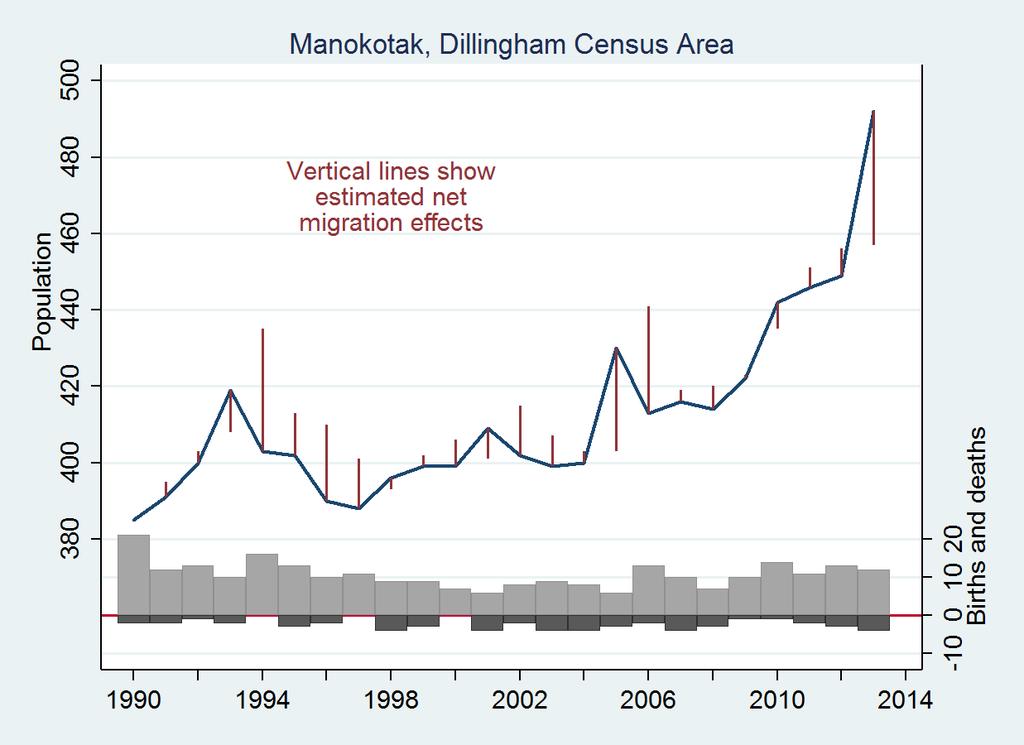
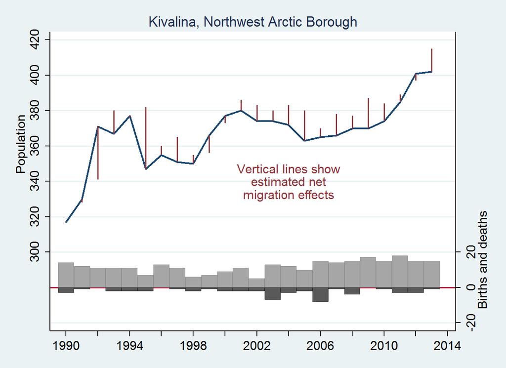
4 Population and vital statistics data Annual mid-year estimates of community population were obtained from the U.S. Census or, between Census years, the Alaska Department of Labor and Workforce Development. The Department of Labor and Workforce Development estimates population using administrative data, notably Permanent Fund Dividend applications a unique resource permitting what the U.S. Census Bureau has judged to be the most accurate yearly estimates of any U.S. state (Alaska Department of Labor and Workforce Development 2008). Counts of births and deaths in each fiscal year are provided by the Alaska Bureau of Vital Statistics. Fiscal year 2013, for example, counts births and deaths from July through June This corresponds approximately to the time frame of population counts as well. Net migration each year is estimated from the difference between this year s population, and last year s population adjusted for births and deaths. More details and discussion of these data and the graphical approach can be found in the following papers: Hamilton, L.C. and A.M. Mitiguy Visualizing population dynamics of Alaska s Arctic communities. Arctic 62(4): Hamilton, L.C., D.M. White, R.B. Lammers and G. Myerchin Population, climate and electricity use in the Arctic: Integrated analysis of Alaska community data. Population and Environment 33(4): doi: /s Hamilton, L.C. Climate and demographic change in Arctic Alaska Pp in K.G. Hansen, R.O. Rasmussen and R. Weber (eds.), Proceedings from the First International Conference on Urbanisation in the Arctic. Stockholm, Sweden: Nordregio.
5 Temperature and precipitation data Sampling MERRA climate data for Alaskan communities NASA's Modern-Era Retrospective Analysis for Research and Applications (MERRA) climate reanalysis product (Rienecker et al., 2011) generated by the GMAO office was used to produce temperature and precipitation inputs for each of the n = 51 Alaskan communities. The MERRA products were created using version of the Goddard Earth Observing System model (GEOS-5 DAS) with a spatial resolution of ½ x 2/3 of a degree over the temporal range from 1979 to present and a 6-hour time step. The temperature and precipitation data were aggregated to monthly time steps and latitude and longitude coordinates for each community were used to extract the climate time series with nearest neighbor sampling. Rienecker, Michele M., and Coauthors (2011) MERRA: NASA s Modern-Era Retrospective Analysis for Research and Applications. Journal of Climate, doi: The central web address for the MERRA products is
6 Bethel Census Area Aniak Bethel Tuluksak

7

8

9
10 Dillingham Census Area Aleknagik Dillingham Manokotak New Stuyahok Togiak

11
12
13

14

15
16 Nome Census Area Brevig Mission Diomede Elim Gambell Golovin Koyuk Nome Saint Michael Savoonga Shaktoolik Shishmaref Stebbins Teller Unalakleet Wales White Mountain
17

18
19

20
21
22

23

24
25
26
27
28

29

30

31

32
33 Anaktuvuk Pass Atqasuk Barrow Kaktovik Nuiqsut Point Hope Point Lay Wainwright North Slope Borough

34

35

36

37

38
39
40

41
42 Northwest Arctic Borough Ambler Buckland Deering Kiana Kivalina Kobuk Kotzebue Noatak Noorvik Selawik Shungnak

43

44

45

46
47
48

49
50

51

52

53
Alaska Housing Market Indicators
 Tables - 4th Quarter, 2017 Description Section Lenders Survey Historical Loan Data 1 Single-Family, Condominium & Mltx Loan Activity Summary 2 New vs. Existing Loan Activity Summary 3 Refinance Loan Activity
Alaska Housing Market Indicators
 Tables - 1st Quarter, 2018 Description Section Lenders Survey Historical Loan Data 1 Single-Family, Condominium & Mltx Loan Activity Summary 2 New vs. Existing Loan Activity Summary 3 Refinance Loan Activity
Alaska Baseline Erosion Assessment Alaskan Communities Affected by Erosion 2 June 2008
 Alaska Baseline Erosion Assessment Alaskan Affected by Erosion 2 June 2008 Recent Updates The Corps is nearing completion of the preliminary draft of the Erosion Information Papers (EIP), with about 50
Linking pan-arctic human and physical data
 6 May 2011 Lawrence C. Hamilton Department of Sociology University of New Hampshire Durham, NH 03824 USA Lawrence.Hamilton@unh.edu Linking pan-arctic human and physical data Richard B. Lammers Water Systems
Physical Capacity Data of Charitable Anti-hunger Programs in Alaska. Henryk Szadziewski
 Physical Capacity Data of Charitable Anti-hunger Programs in Alaska Henryk Szadziewski September 27, 2006 Table of Contents A Brief Note on Presentation...3 Section 1 - Facility and Equipment Data...4-24
Understanding coastal erosion in Alaska
 Understanding coastal erosion in Alaska Alaska Center for Climate Assessment and Policy Statewide Teleconference October 9, 2007. David E. Atkinson International Arctic Research Center / Atmospheric Science
Alaska Statewide Climate Summary February 2019
 Alaska Statewide Climate Summary February 2019 The following report provides an overview of the February 2019 weather. The report is based on preliminary data from selected weather stations throughout
Investigation on the use of NCEP/NCAR, MERRA and NCEP/CFSR reanalysis data in wind resource analysis
 Investigation on the use of NCEP/NCAR, MERRA and NCEP/CFSR reanalysis data in wind resource analysis Sónia Liléo, PhD Wind resource analyst - R&D manager O2 Vind AB Stockholm, Sweden sonia.lileo@o2.se
U.S. Department of the Interior Alaska Rural Energy Project
 U.S. Department of the Interior Alaska Rural Energy Project Results from the Coalbed Methane Exploration and Testing Project Wainwright, Alaska 2007-2008 2008 Art Clark U.S. Geological Survey, Denver,
Changing Landscapes. Coastal Erosion. Middle School Guide. REACH Up Raising Educational Achievement. through Cultural Heritage Up
 Changing Landscapes Coastal Erosion Middle School Guide REACH Up Raising Educational Achievement through Cultural Heritage Up Changing Landscapes How does climate change impact the landscape? The climate
Spatial Optimization of CoCoRAHS Network in Tennessee. Joanne Logan Department of Biosystems Engineering and Soil Science University of Tennessee
 Spatial Optimization of CoCoRAHS Network in Tennessee Joanne Logan Department of Biosystems Engineering and Soil Science University of Tennessee Abstract CoCoRaHS (Community Collaborative Rain, Hail and
Understanding China Census Data with GIS By Shuming Bao and Susan Haynie China Data Center, University of Michigan
 Understanding China Census Data with GIS By Shuming Bao and Susan Haynie China Data Center, University of Michigan The Census data for China provides comprehensive demographic and business information
Developing Cross-cultural Education Programs
 Developing Cross-cultural Education Programs Kathy Bertram Director, Education Outreach Office Geophysical Institute University of Alaska Fairbanks Communicating Science in Native Cultures Alaska Native
NORTH SLOPE BOROUGH FIRE DEPARTMENT
 NORTH SLOPE BOROUGH FIRE DEPARTMENT I. MISSION The mission of the Fire Department is to preserve life and property using community volunteers and career personnel to deliver ground and air emergency medical
Mike Sfraga, Director UA Geography Program Scott Rupp, Director SNAP Katie Kennedy, Outreach Coordinator UAGP
 Mike Sfraga, Director UA Geography Program Scott Rupp, Director SNAP Katie Kennedy, Outreach Coordinator UAGP What is SNAP? SNAP is a collaborative network of the University of Alaska, state, federal,
UNIVERSITY OF KWAZULU-NATAL EXAMINATION: JUNE 2012 Howard College and Westville Campuses
 UNIVERSITY OF KWAZULU-NATAL EXAMINATION: JUNE 2012 Howard College and Westville Campuses SCHOOL : AGRICULTURE, EARTH AND ENVIRONMENTAL SCIENCES LEVEL : 1 MODULE : HUMAN ENVIRONMENTS CODE : GEOG 110 H1/W1
Alaska Statewide Climate Summary June 2018
 Alaska Statewide Climate Summary June 2018 The following report provides an overview of temperature and precipitation for June 2018. The report is based on preliminary data from selected weather stations
NEAR REAL TIME GLOBAL RADIATION AND METEOROLOGY WEB SERVICES AVAILABLE FROM NASA
 NEARREAL TIMEGLOBALRADIATIONANDMETEOROLOGYWEBSERVICESAVAILABLE FROMNASA ABSTRACT WilliamS.Chandler JamesM.Hoell DavidWestberg CharlesH.Whitlock TaipingZhang ScienceSystems&Applications,Inc. OneEnterpriseParkway,Suite200
RESEARCH METHODOLOGY
 III. RESEARCH METHODOLOGY 3.1 Time and Location This research has been conducted in period March until October 2010. Location of research is over Sumatra terrain. Figure 3.1 show the area of interest of
ANALYZING CITIES & POPULATION: POPULATION GEOGRAPHY
 ANALYZING CITIES & POPULATION: POPULATION GEOGRAPHY Population Geography Population Geography study of the number, contribution, and distribution of human populations Demography the study of the characteristics
Intercity Bus Stop Analysis
 by Karalyn Clouser, Research Associate and David Kack, Director of the Small Urban and Rural Livability Center Western Transportation Institute College of Engineering Montana State University Report prepared
Assimilating Earth System Observations at NASA: MERRA and Beyond
 Assimilating Earth System Observations at NASA: MERRA and Beyond Siegfried Schubert, Michael Bosilovich, Michele Rienecker, Max Suarez, Ron Gelaro, Randy Koster, Julio Bacmeister, Ricardo Todling, Larry
CLIMATE CHANGE AND SHORT-TERM FORECASTING FOR ALASKAN NORTHERN COASTS Gary Hufford * and James Partain National Weather Service, Anchorage, Alaska
 CLIMATE CHANGE AND SHORT-TERM FORECASTING FOR ALASKAN NORTHERN COASTS Gary Hufford * and James Partain National Weather Service, Anchorage, Alaska 1. INTRODUCTION Global climate models project that the
Alaska Statewide Climate Summary March 2019
 Alaska Statewide Climate Summary March 2019 The following report provides an overview of the March 2019 weather. The report is based on preliminary data from selected weather stations throughout the state
HOW FAR TO THE NEAREST PHYSICIAN?
 Rural and Small Town Canada Analysis Bulletin Catalogue no. 21-006-XIE Vol. 1, No. 5 (March 1999) HOW FAR TO THE NEAREST PHYSICIAN? Edward Ng, Russell Wilkins, Jason Pole and Owen B. Adams HIGHLIGHTS In
Observation-Corrected Precipitation Estimates in GEOS-5
 NASA/TM 2014-104606 / Vol. 35 Technical Report Series on Global Modeling and Data Assimilation, Volume 35 Randal D. Koster, Editor Observation-Corrected Precipitation Estimates in GEOS-5 Rolf H. Reichle
The Soil Atlas of the Northern Circumpolar Region
 Conference Soil, Climate Change and Biodiversity Where do we stand? Brussels, Thursday 23rd and Friday 24th September 2010 1 The Soil Atlas of the Northern Circumpolar Region Luca Montanarella European
The importance of international university and project cooperation in science
 The importance of international university and project cooperation in science The Role of Science in Arctic Social and Business Development Arctic Frontiers Science January 25, 2017 Dr. Marina Kalinina
A Case Study of Regional Dynamics of China 中国区域动态案例研究
 A Case Study of Regional Dynamics of China 中国区域动态案例研究 Shuming Bao Spatial Data Center & China Data Center University of Michigan 1:00 PM - 2:00 PM, Tue, Feb 6, 2018 EST USA A Case Study of Regional Dynamics
Demographic Data in ArcGIS. Harry J. Moore IV
 Demographic Data in ArcGIS Harry J. Moore IV Outline What is demographic data? Esri Demographic data - Real world examples with GIS - Redistricting - Emergency Preparedness - Economic Development Next
Compact guides GISCO. Geographic information system of the Commission
 Compact guides GISCO Geographic information system of the Commission What is GISCO? GISCO, the Geographic Information System of the COmmission, is a permanent service of Eurostat that fulfils the requirements
LandScan Global Population Database
 LandScan Global Population Database The World s Finest Population Distribution Data Uncommon information. Extraordinary places. LandScan Global Population Database East View Cartographic is now offering
CAPE Unit 1 Module 2 & 3. Topic Specific Objectives Content Explain the main concepts, flows and processes associated with coastal environments
 # Week(s) Wks 1-3 CAPE Unit 1 Module 2 & 3 Topic Specific Objectives Content Explain the main concepts, flows and processes associated with coastal environments Wave formation, structure, types Textbook
Alaska Statewide Climate Summary November 2018
 Alaska Statewide Climate Summary November 2018 The following report provides an overview of the November 2018 weather. The report is based on preliminary data from selected weather stations throughout
GC1DR Exam Review 2013
 GC1DR Exam Review 2013 Name: Your exam is just around the corner! By completing this review, you will be EXTREMELY well prepared to write this exam. Part A ON A SEPARATE PIECE OF PAPER, please complete
Geography for the 2020 Round of Census
 Boundaries Key Census Data EA Id Population Male Female EA Id Area EA Id Num HH Avg HH size Geography for the 2020 Round of Census Linda Peters, Esri lpeters@esri.com Integration of Statistical and Geospatial
Public School Funding Program Overview
 Public School Funding Program Overview Updated January 2018 1 January 2018 Table of Contents Alaska Department of Education & Early Development Student Based Formula District Adjusted ADM 3 ADM Reporting
Climate Change in Newfoundland & Labrador
 Climate Change in Newfoundland & Labrador Impacts and Adaptation Newleef Conference 08 October 2015 Met-Ocean Services The Team 55 personnel; 24/7 operational weather forecast desk; Equipment technician
23. SUBSISTENCE USES AND TRADITIONAL KNOWLEDGE
 23. SUBSISTENCE USES AND TRADITIONAL KNOWLEDGE 23.1 Introduction The purpose of the subsistence uses and traditional knowledge study is to establish a description of subsistence uses and knowledge of local
Climate scenarios and vulnerabilities in the Aleutian and Bering Sea islands John Walsh, University of Alaska Fairbanks
 Climate scenarios and vulnerabilities in the Aleutian and Bering Sea islands John Walsh, University of Alaska Fairbanks Nick Bond, NOAA Pacific Marine Environmental Laboratory Why do we need to downscale
WHAT ARE SOME OF EARTH S LANDFORMS?
 Overview In this lesson, students will observe local land features. Students use their observations to create a model of a single landform, then write a creation story about that feature. Objectives On
Indicators for sustainable circum-arctic coastal communities
 Indicators for sustainable circum-arctic coastal communities Donald Forbes, Trevor Bell, Joan Nymand Larsen, Andrey Petrov, Peter Pulsifer, Rasmus Ole Rasmussen, Rudy Riedlsperger, Peter Schweitzer A subset
The Global Statistical Geospatial Framework and the Global Fundamental Geospatial Themes
 The Global Statistical Geospatial Framework and the Global Fundamental Geospatial Themes Sub-regional workshop on integration of administrative data, big data and geospatial information for the compilation
Improving the representation of the Greater Arctic with ASRv2. D. H. Bromwich and many collaborators
 Improving the representation of the Greater Arctic with ASRv2 D. H. Bromwich and many collaborators 5 th International Conference on Reanalysis (ICR5) Rome, Italy 14 November 2017 Importance of an Arctic-focused
NSF s Role in Funding Laboratory Astrophysics
 NSF s Role in Funding Laboratory Astrophysics Harshal Gupta hgupta@nsf.gov Division of Astronomical Sciences (AST) Directorate for Mathematical and Physical Sciences National Science Foundation NASA Laboratory
TOWARDS STRATEGIC SPATIAL PLANNING IN JAMAICA: THE NATIONAL SPATIAL PLAN
 TOWARDS STRATEGIC SPATIAL PLANNING IN JAMAICA: THE NATIONAL SPATIAL PLAN JIEP 5th Biennial Conference on the Environment: Balancing National Development and Environmental Protection June 6, 2011 Jamaica
A Summary of Dall Sheep Harvests in 14 Game Management Units in Alaska
 Special Publication No. BOG 2015-01 A Summary of Dall Sheep Harvests in 14 Game Management Units in Alaska by David Koster and Davin Holen January 2015 Alaska Department of Fish and Game Division of Subsistence
Alaska Ocean Observing System 101 Anchorage, Alaska
 Alaska Ocean Observing System 101 Anchorage, Alaska Molly McCammon, Director Alaska Ocean Observing System (AOOS) A Regional Observing System within the Integrated Ocean Observing System www.aoos.org IOOS
 www.onlineexamhelp.com www.onlineexamhelp.com UNIVERSITY OF CAMBRIDGE INTERNATIONAL EXAMINATIONS General Certificate of Education Advanced Subsidiary Level and Advanced Level *8483922912* GEOGRAPHY 9696/13
Geological Survey of Canada Lands and Minerals Sector Natural Resources Canada OneGeology, June 2018
 Geological Survey of Canada Lands and Minerals Sector Natural Resources Canada OneGeology, June 2018 Geological Survey of Canada Mission The Geological Survey of Canada provides public geoscience knowledge
Status of Atmospheric Winds in Relation to Infrasound. Douglas P. Drob Space Science Division Naval Research Laboratory Washington, DC 20375
 Status of Atmospheric Winds in Relation to Infrasound Douglas P. Drob Space Science Division Naval Research Laboratory Washington, DC 20375 GOT WINDS? Douglas P. Drob Space Science Division Naval Research
UNIVERSITY OF CAMBRIDGE INTERNATIONAL EXAMINATIONS General Certifi cate of Education Advanced Subsidiary Level and Advanced Level
 UNIVERSITY OF CAMBRIDGE INTERNATIONAL EXAMINATIONS General Certifi cate of Education Advanced Subsidiary Level and Advanced Level *3321951161* GEOGRAPHY 9696/01 Paper 1 Core Geography May/June 2008 Additional
Introducing the WISERD Geoportal. WISERD DATA TEAM Dr Robert Berry & Dr Richard Fry, University of Glamorgan Dr Scott Orford, Cardiff University
 Introducing the WISERD Geoportal WISERD DATA TEAM Dr Robert Berry & Dr Richard Fry, University of Glamorgan Dr Scott Orford, Cardiff University WISERD What is WISERD? Wales Institute of Social and Economic
What s new (or not so new) in Population and Poverty Data Initiatives
 in Population and Poverty Data Initiatives") What s new (or not so new) in Population and Poverty Data Initiatives Deborah Balk Global Spatial Data and Information User Workshop 21 September 2004 Evolution in global collection of population and poverty
What s new (or not so new) in Population and Poverty Data Initiatives Deborah Balk Global Spatial Data and Information User Workshop 21 September 2004 Evolution in global collection of population and poverty
3 rd Grade Social Studies
 3 rd Grade Social Studies UNITED STATES HISTORY Year 1: American Indian Cultures through Colonization In third grade, students begin a three-year study of United States history in which all four strands
Third Grade United States History
 Third Grade United States History Year 1: American Indian Cultures through Colonization In third grade, students begin a three-year study of United States history in which all four strands (history, geography,
Sustaining Arctic Observing Networks SAON
 Sustaining Arctic Observing Networks SAON Atmosphere Breakout Group Stockholm, Sweden November 12 14, 2007 Lisa Darby (NOAA) & Jussi Paatero (FMI) What role does the atmosphere play in the reduction of
Use of GIS in road sector analysis
 Use of GIS in road sector analysis Uwe Deichmann, DECRG March 30, 2007 Transport Forum and Learning Week 2007 Transport Measurement Matters Indicators of Performance and Impact Geographic information Using
Summary and Statistical Report of the 2007 Population and Housing Census Results 1
 Summary and Statistical Report of the 2007 Population and Housing Census Results 1 2 Summary and Statistical Report of the 2007 Population and Housing Census Results This document was printed by United
Statistical perspectives on spatial social science
 Statistical perspectives on spatial social science Discussion Sarah Nusser (nusser@iastate.edu) Center for Survey Statistics and Methodology Department of Statistics Iowa State University Morris Hansen
Alaska Statewide Climate Summary December 2018
 Alaska Statewide Climate Summary December 2018 The following report provides an overview of the December 2018 weather. The report is based on preliminary data from selected weather stations throughout
GEOGRAPHIC INFORMATION SYSTEMS Session 8
 GEOGRAPHIC INFORMATION SYSTEMS Session 8 Introduction Geography underpins all activities associated with a census Census geography is essential to plan and manage fieldwork as well as to report results
Paul W. Stackhouse, Jr., NASA Langley Research Center
 An Assessment of Actual and Potential Building Climate Zone Change and Variability From the Last 30 Years Through 2100 Using NASA s MERRA and CMIP5 Simulations Paul W. Stackhouse, Jr., NASA Langley Research
Policy Paper Alabama Primary Care Service Areas
 Aim and Purpose Policy Paper Alabama Primary Care Service Areas Produced by the Office for Family Health Education & Research, UAB School of Medicine To create primary care rational service areas (PCSA)
Alaska Resource Overview
 Alaska Resource Overview Kennicott Mine JOGMEC Presentation Tokyo, Japan November 7, 2006 Tom Crafford, Mining Coordinator tom_crafford@dnr.state.ak.us Alaska Department of Natural Resources Office of
'ATM'493/693'Applied'Arc/c'Climate'Problems'' Spring'2017'University'of'Alaska'Fairbanks'='Don t'be'leo'out!''
 'ATM'493/693'Applied'Arc/c'Climate'Problems'' Spring'2017'University'of'Alaska'Fairbanks'='Don t'be'leo'out!'' Calling'undergraduates'and'graduate'students'interested' in'understanding'and'par/cipa/ng'in'the'process'of'taking'
Reducing Vulnerability to Extreme Heat: Science-Policy Interface
 Reducing Vulnerability to Extreme Heat: Science-Policy Interface Olga Wilhelmi, Mary Hayden, Jennifer Boehnert, Ursula Lauper and SIMMER research team October 23, 2013 Toronto SIMMER workshop Science-Policy
MACSSIMIZE. Measurements of Arctic Clouds, Snow, and Sea Ice nearby the Marginal Ice ZonE. Principal investigator. Chawn Harlow
 MACSSIMIZE Measurements of Arctic Clouds, Snow, and Sea Ice nearby the Marginal Ice ZonE Principal investigator Chawn Harlow chawn.harlow@metoffice.gov.uk Met Office Areas of contribution Polar atmospheric
Factors that Shape Places Stage 3 Geography
 Factors that Shape Places Stage 3 Geography Summary This unit is written for Stage 3 "Factors that shape places". It is a Geographical Inquiry, enabling students to work through the 3 stages of inquiry;
PIRE. william m. trigg NOAA- National Mather Service U.S. Department of Commerce 7379/33 $97. 1m "
 r'r )..? -. e 7379/33 $97 r 4 *-. 50133 Ov, 1 PIRE * C 1m " U~DA Forest Service Research -Paper PN W -126. '. -. 4 -. -.. - r ' william m. trigg NOAA- National Mather Service U.S. Department of Commerce
CONFERENCE STATEMENT
 Final draft CONFERENCE STATEMENT We, the elected representatives of Canada, Denmark/Greenland, the European Parliament, Finland, Iceland, Norway, Russia, Sweden and the United States of America; In collaboration
AS Population Change Question spotting
 AS Change Question spotting Changing rate of growth How the rate of growth has changed over the last 100 years Explain the reasons for these changes Describe global or national distribution. Study the
Presented by Larry Rundquist Alaska-Pacific River Forecast Center Anchorage, Alaska April 14, 2009
 Presented by Larry Rundquist Alaska-Pacific River Forecast Center Anchorage, Alaska April 14, 2009 Presentation Outline Who we are Breakup characteristics Climate and weather influences 2009 breakup outlook
CHALLENGES IN CONDUCTING SURVEYS/CENSUSES
 WORKSHOP ON MONITORING FOOD SECURITY IN THE CONTEXT OF 2030 SUSTAINABLE DEVELOPMENT AGENDA 22-23 FEBRUARY 2017 ANKARA, TURKEY CHALLENGES IN CONDUCTING SURVEYS/CENSUSES WAQAR ASLAM PAKISTAN BUREAU OF STATISTICS
Population Trends Along the Coastal United States:
 Coastal Trends Report Series Population Trends Along the Coastal United States: 1980-2008 U.S. Department of Commerce National Oceanic and Atmospheric Administration National Ocean Service Assessing the
Arctic Nautical Charting Plan A Plan to Support Sustainable Marine Transportation in Alaska and the Arctic
 Arctic Nautical Charting Plan A Plan to Support Sustainable Marine Transportation in Alaska and the Arctic Office of Coast Survey Marine Chart Division February 15, 2013 Record of Changes Page Change 3
CHANGING CLIMATE Observing Weather
 MIDDLE SCHOOL TEACHER GUIDE Table of Contents Introduction Page Whole Picture............................................................... 2 Vocabulary.................................................................
Space Application in Support of Land Management for SDG Implementation
 Space Application in Support of Land Management for SDG Implementation Regional Expert Workshop on Land Accounting for SDG Monitoring and Reporting 26 September 2017 Space Application Section Information
Global Land Project: major scientific questions for coupled modelling
 Global Land Project: major scientific questions for coupled modelling Richard Aspinall Macaulay Land Use Research Institute and GLP Nodal Office on Integration and Modelling Aberdeen, Scotland NATO Advanced
CENSUS MAPPING WITH GIS IN NAMIBIA. BY Mrs. Ottilie Mwazi Central Bureau of Statistics Tel: October 2007
 CENSUS MAPPING WITH GIS IN NAMIBIA BY Mrs. Ottilie Mwazi Central Bureau of Statistics E-mail: omwazi@npc.gov.na Tel: + 264 61 283 4060 October 2007 Content of Presentation HISTORICAL BACKGROUND OF CENSUS
Scaling the Software and Advancing the Science of Global Modeling and Assimilation Systems at NASA. Bill Putman
 Global Modeling and Assimilation Office Scaling the Software and Advancing the Science of Global Modeling and Assimilation Systems at NASA Bill Putman Max Suarez, Lawrence Takacs, Atanas Trayanov and Hamid
2015 Copyright Board of Studies, Teaching and Educational Standards NSW for and on behalf of the Crown in right of the State of New South Wales.
 2015 Copyright Board of Studies, Teaching and Educational Standards NSW for and on behalf of the Crown in right of the State of New South Wales. This document contains Material prepared by the Board of
WHAT S COOKING AT THE ESRGC? Michael S. Scott, PhD, GISP Eastern Shore Regional GIS Cooperative Salisbury University
 WHAT S COOKING AT THE ESRGC? Michael S. Scott, PhD, GISP Eastern Shore Regional GIS Cooperative Salisbury University ESRGC For more than a decade Established in 2004 as a self-sustaining collaboration
Answers to Saskatchewan Quizzes
 Answers to Saskatchewan Quizzes Test Your Knowledge What do you remember from your review of the Saskatchewan section of the E-Atlas? 1. Saskatchewan and Canada s sunniest city is a) Regina b) Saskatoon
8-km Historical Datasets for FPA
 Program for Climate, Ecosystem and Fire Applications 8-km Historical Datasets for FPA Project Report John T. Abatzoglou Timothy J. Brown Division of Atmospheric Sciences. CEFA Report 09-04 June 2009 8-km
Capacity building and the global human settlement data. Richard Sliuzas, University of Twente Vincent Seaman, Bill & Melinda Gates Foundation
 Capacity building and the global human settlement data Richard Sliuzas, University of Twente Vincent Seaman, Bill & Melinda Gates Foundation Content Capacity development Capabilities approach Some issues
Pseudo-Global warming approach using 4KM WRF model
 Pseudo-Global warming approach using 4KM WRF model S. Kurkute 1,2 Y. Li 1,2 1 School of Environment and Sustainability University of Saskatchewan 2 Global Institute of Water Security University of Saskatchewan
Alaska Earthquake Center. By Natalia A. Ruppert Seismic Network Manager
 Alaska Earthquake Center By Natalia A. Ruppert Seismic Network Manager Geophysical Institute, University of Alaska Fairbanks Alaska Earthquake Center mission and historical perspective! Regional seismic
ALASKA REGION CLIMATE FORECAST BRIEFING. December 15, 2014 Rick Thoman NWS Alaska Region ESSD Climate Services
 ALASKA REGION CLIMATE FORECAST BRIEFING December 15, 2014 Rick Thoman NWS Alaska Region ESSD Climate Services Today Climate Forecast Basics Review of recent climate forecasts and conditions CPC Forecasts
NSF Grants Conference Denver June 23-24, 2014
 NSF Grants Conference Denver June 23-24, 2014 NSF Directorate for Geosciences Sarah Ruth, DPhil Division of Atmospheric and Geospace Sciences sruth@nsf.gov 1 Directorate for Geosciences: Our Mission Support
Current Status of the Stratospheric Ozone Layer From: UNEP Environmental Effects of Ozone Depletion and Its Interaction with Climate Change
 Goals Produce a data product that allows users to acquire time series of the distribution of UV-B radiation across the continental USA, based upon measurements from the UVMRP. Provide data in a format
Use of Ocean Observations to Develop Forecasts in Support of Fisheries Management
 Use of Ocean Observations to Develop Forecasts in Support of Fisheries Management Phillip R. Mundy Alaska Fisheries Science Center Juneau, Alaska Danielle F. Evenson Alaska Department of Fish and Game
The National Operational Hydrologic Remote Sensing Center Operational Snow Analysis
 The National Operational Hydrologic Remote Sensing Center Operational Snow Analysis World Meteorological Organization Global Cryosphere Watch Snow-Watch Workshop Session 3: Snow Analysis Products Andrew
Rainforests and Deserts: Distribution, Uses, and Human Influences. Teacher s Masters California Education and the Environment Initiative
 E Teacher s Masters California Education and the Environment Initiative Earth Science Standard E.5.e. Rainforests and Deserts: Distribution, Uses, and Human Influences California Education and the Environment
NATIONAL SENIOR CERTIFICATE GRADE 12
 NATIONAL SENIOR CERTIFICATE GRADE 12 GEOGRAPHY P1 FEBRUARY/MARCH 2015 MARKS: 225 TIME: 3 hours This question paper consists of 12 pages and an annexure of 12 pages. *GEOGE1* Geography/P1 2 INSTRUCTIONS
Michael Thomas Sullivan
 Michael Thomas Sullivan michael.sullivan2@lc.cuny.edu Home Address 2319 Brigham Street Brooklyn, NY 11229 Cell (516) 729-8870 Academic Address Geographic Information Science Dept. Lehman College, CUNY
Atmospheric science research for numerical weather prediction and climate modeling in Slovenia: contribution of the PECS program
 Atmospheric science research for numerical weather prediction and climate modeling in Slovenia: contribution of the PECS program Matic Šavli, Žiga Zaplotnik, Veronika Hladnik, Gregor Skok and Nedjeljka
Social Science Data for High Latitudes
 LCLUC Science Team Meeting High Latitudes in the Context of the International Polar Year Social Science Data for High Latitudes 2 May 2008 Dr. Robert S. Chen Director and Senior Research Scientist, CIESIN
Improving rural statistics. Defining rural territories and key indicators of rural development
 Improving rural statistics Defining rural territories and key indicators of rural development Improving rural statistics Improving Rural Statistics In 2016, the Global Strategy to improve Agricultural
Mapping the Future: Energizing Datadriven
 Mapping the Future: Energizing Datadriven Policy Making and Investment in Renewable Energy Anthony Lopez Manager Geospatial Data Science National Renewable Energy Laboratory June 6, 2016 Outline Context