REPORT ON DIVISIONAL LEVEL TRAINING PROGRAM ON. APPLICATION OF REMOTE SENSING AND GIS FOR GOVERNANCE (Held during August and September, 2013)
|
|
|
- Dustin Davis
- 6 years ago
- Views:
Transcription

1 REPORT ON DIVISIONAL LEVEL TRAINING PROGRAM ON APPLICATION OF REMOTE SENSING AND GIS FOR GOVERNANCE (Held during August and September, 2013) Co-ordinator: H Hemanth Kumar Fellow & Principal Investigator NRDMS Karnataka State Council for Science and Technology Indian Institute of Science, Bangalore Phone: , Telefax: office@kscst.org.in Website:
2 REPORT ON DIVISIONAL LEVEL TRAINING PROGRAM ON APPLICATION OF REMOTE SENSING AND GIS FOR GOVERNANCE (Held during August and September, 2013) Dr. M. Prithviraj Executive Secretary Prof. M.S. Mohan Kumar Secretary Karnataka State Council for Science and Technology Indian Institute of Science, Bangalore Phone: , Telefax: Website:
3 DIVISIONAL LEVEL TRAINING PROGRAMS ON APPLICATION OF REMOTE SENSING AND GIS FOR GOVERNANCE (Held during August and September, 2013) Background: Under a joint project of Natural Resources Data Management System (NRDMS) of Department of Science & Technology, Government of India, and the Government of Karnataka, Karnataka State Council for Science & Technology (KSCST), Bangalore has developed district level GIS databases to support the process of Local Level Planning at the levels of district, taluk and village. Over the past two decade all the thirty districts of Karnataka State have been covered under NRDMS. The NRDMS has been institutionalized in the state, through the Department of Rural Development and Panchayath Raj and is supporting 30 Zilla Panchayaths for implementation of their activities and plans. With increasing dependence of the Zilla Panchayaths/Urban local bodies, Line Departments and other stake-holders of local level planning on spatial datasets, a need has been felt to speed up the process of discovery of and access to up-to-date spatial datasets, the Council with the support DST - GoI and DST GoK has developed a Geoportal and Data Clearing House to discover/ access spatial data sets useful in the local level planning process through Karnataka State Spatial Data Infrastructure (KSSDI) Project. Karnataka Geo-portal for the benefit of planners and administrators; provides seamless state-wide GIS database on selected layers viz. administrative boundaries, derived boundaries for Panchayath raj institutions for administration, infrastructure maps (on amenities and utilities) etc. The spatial data is free and open to all for viewing-access and discovery. The KSSDI portal passed preliminary stage of development and was released to users during October, 2009 for portal functionality testing. The release allowed the testing of the portal to undergo usability testing with selected users who provided feedback to the project team. Identified malfunctions were rectified. The Council officially launched Karnataka Geoportal during December, 2009 at the 9 th annual event of National Spatial Data infrastructure by the Honourable Minister of State for Science & technology, GOI, Sri. Prithviraj Chavan. The portal was also dedicated to the state of Karnataka in the national event i.e., NSDI-12 meet held in Bangalore. The Council in the 2 nd phase of the Karnataka Geoportal has plans to implement online web map solutions and spatial services such as transactional web feature services (WFS-T), Geo-web services. Geo visualization, publishing meta data (both for data and services), searching and examining spatial data or
4 services etc. An R&D project costing around Rs. 71 lakhs has been sanctioned to KSCST during March, 2013 to develop web based geospatial applications/decision support system for selected schemes of Watershed and Health Departments to support G-governance on Karnataka Geoportal platform. The 2 nd phase of KSSDI project is expected to maximize utilization of the Karnataka State Geoportal and to demonstrate the utility of the Geoportal in two identified sectors i.e. Watershed Management and Health. The concept of g-governance i.e., to plan, monitor, review and evaluate several government schemes requiring spatial datasets is planned to be demonstrated on Karnataka Geoportal platform. In Karnataka, satellite images and GIS have been used from late 1980 onwards and Karnataka was one of the first state to establish, in 1986, a separate Karnataka State RS Utilization Centre which later was renamed, in 1997, as Karnataka State RS Applications Centre (KSRSAC). In the past 25 years, KSRSAC has brought in a variety of RS and GIS applications for different users and has or ganized a variety of GIS databases for the state thereby supporting a large number of departments/projects of GOK with valuable maps and GIS data and also being a focal point for RS images. As a result of these efforts of KSRSAC, over the past 10 years, use of satellite/aerial images and GIS have proliferated in various departments of GOK - Department of Forests, Town Planning Department, Department of Agriculture, Urban Development Department, various city municipalities and authorities (Bangalore city was one of the first cities to use RS and GIS for urban planning and now Mysore, Hubli, Mangalore and many others adopt GIS), Irrigation Department, Mines and Geology department and many others have been using RS and GIS as part of their projects. The Karnataka State Natural Disaster Management Centre (KSNDMC) has excellent application and infrastructure in the field of Disaster Management, including early warning and mitigation aspects. KSNDMC collects weather, geological, hydrological data on real time. KSNDMC operates a Master Control Facility, which is supported by a network of 1600 Telemetric Rain Gauges, 200 Satellite and GPRS linked weather stations, 13 Earthquake Monitoring Stations all of these pumping weather/disaster data on a continuous basis to a centralized GIS database and a web enabled GIS Applications system with modern geo-information processing and real-time communication/delivery systems. In the late 1990s, many private organizations also started providing RS and GIS services to end users. Purpose and intentions of workshop:
5 Even though many agencies are providing geospatial services in the state, it is generally seen that the utility of GIS in not profoundly seen in governance. The full potential of GIS technology is yet to be achieved and exploited in the state for decision-support by planners, decision-makers, citizens and many others who are stake holders for governance. Mainly the GIS initiatives have been successful in sporadic cases where individuals have taken interest and lead in a project mode, and GIS is yet to be integrated in governance due to lack of mandate to the departments through policy initiatives. Few other reasons for this situation are (i) lack of easily available and regularly updated GIS-Ready data, and (ii) lack of user friendly GIS apps. To create awareness and to showcase the potential of web based geospatial technologies, a one-day Divisional Level Training-workshop on Geospatial Technology was held in all the four divisions of Karnataka during August September, 2013 with the concurrence of Rural Development and Panchayath Raj (RDPR) department. The workshop was primarily aimed at familiarizing geospatial technologies through lectures and with ample usage of case studies. The workshop is expected to help the implementing agencies to understand the importance of GIS and RS for planning and implementation on the field and orient the resource maps with the field conditions. The spatial data for effective implementation of various rural schemes using scientifically prepared action plan maps.
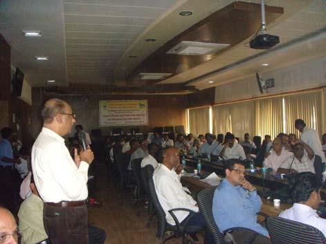
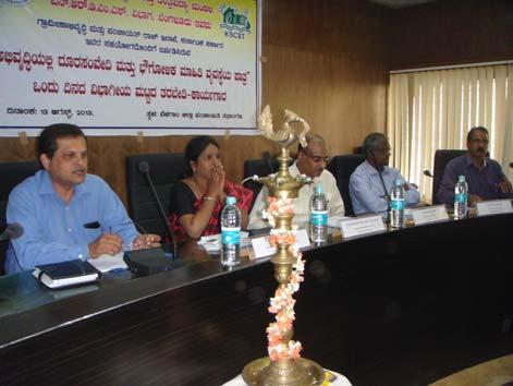
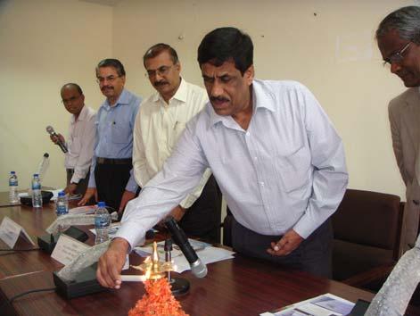
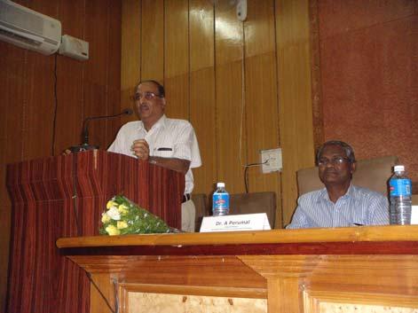
6 13 August, 2013 Belgaum Division Training-Workshop The Inaugural function of the first divisional training-workshop was held in the Conference hall of Belgaum Zilla Panchayat, Belgaum on 13 th August The workshop was attended by about 100 officials of PRED engineers of the division and district level officers of Agriculture, Watershed, Mines and Geology, Health, Education, Sericulture, Fisheries and Town Planning Authority. The inaugural function startred with welcome speech by Mr.R.G.Nayak, Deputy Secretary (Administration) who invited all dignitaries and participants and in his welcome speech he stressed the importance of remote sensing and GIS in current scenario in implementing government work for better governance. Smt. Deepa Cholan, CEO of Ziila Panchayat, Belgaum inaugurated the function by lighting the lamp and in her addres highlighted the benefits of Remote Sensing and GIS. She informed the district officials to make use of this Training workshop and expected the particapnts to adopt the technologies in their work to bring in transparency and efficiency in implementation of development works of the government. Dr. M Prithviraj, Executive Secretary, KSCST in his presidential remark call upon the officials participanting in the workshop to make use of this opportunity and adopt geospatial technologies to plan and minotor government schemes. After the inaugural function, technical session of the workshop commenced with a brief introduction About Karnataka State Council for Science and Technology by Dr. M Prithviraj, Executive Secretary, KSCST. Mr. H. Hemanth Kumar Fellow and PI-NRDMS program gave a brief introduction to the training-workshop and the relevance of it in the present scenario. He further informed that RDPR is taking keen interest in adopting geospatial technologies for governance and a feedback at the end of these divisional workshop would help them in identifying the key areas for support. Dr. A. Perumal, Chair Professor - Sir MV Geospatial Technology Chair, Indian Institute of Science, Bangalore spoke on the journry of Remote Sensing and GIS applications for Natural Resources Management since ISRO s launch remote sensing satellites. He gave a detailed description of ISRO s efforts in popularsing RS and GIS for planning, data processing and application projects in diversified areas. Prof Perumal in his lecture gave more emphasis to utility of RS and GIS for Conservation, development and optimal utilisation of land and water resources for the ultimate benefit of the people.
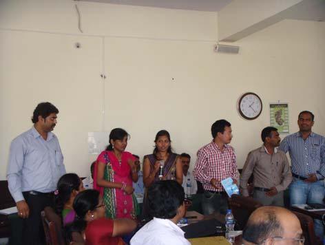
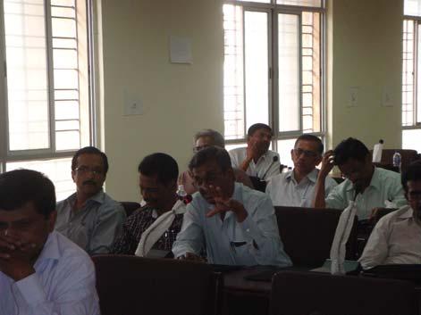
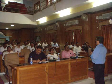
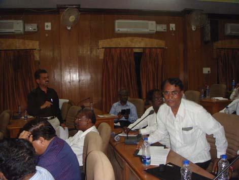
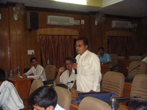
7 Mr. H.Hemanth Kumar, in the morning session delved on NRDMS Program; Introduction to maps and data; Geospatial Technologies for Governance followed by applications of Crowd Sourcing and its demonstration. He informed the 73rd and 74th Amendments of the Indian Constitution passed in 1993 emphasized the need for geospatial data for development planning to local level governments or Panchayats. He told that the objective of NRDMS programme was to establish district NRDMS centers in all the districts to develop spatial database and applications that are relevant to planning and administration for "Decentralized Planning" using geospatial technologies. He explained the journey of NRDMS centers, Establishment of NRDMS centers in all the districts, institutionalization of spatial data centers in Karnataka. With the available data he infoirmed the partaicapnts these district spataial data centres have been providing support to ditrict level planning for all the line departments. Several applications developd by the state and district NRDMS centres on health, crime, urban planning, usage of google maps, MI tanks, watershed, fisheries etc were demonstrated during the workshop. In the afternoon session, Mr. H Hemanth Kumar demonstrated gathering of geospatial information at higher resolution through crowd sourcing concepts apart from providing information on the initiative taken up by the government and the Council in resource mapping; urban and cadastral mapping; use of google and other public portals in adding value to the existing data for planning and monitoring several government schemes. In the afternoon session Mr. Anil R. Naik of Uttara Kannada District NRDMS centre highglighted the activities and support provided by his centre to various line departments. After the technical session there was discussion and interaction session where participants raised their queries which were well addressed by experts. On behalf of the Zilla Panchayath, Mr. Manjunath Totad proposed the vote of thanks. The divisional workshop were conducted in other three division with a good number participation of senior officers from line departments and the dates on which they have been conducted is provided under program schedule.
8 Deliberations & conclusions: During interaction with the officials of the line departments, the following issues came up and needs to be resolved to successfully adopt geospatial technologies for governance. a. Desktop/Laptop for all the Group A and Group B officers b. Periodical training and hand-holding of staff including computer operators in geospatial technologies to c. Hardware and software (GIS software, computers, Internet, UPS, printers etc.) d. Directive from the heads of departments to adopt technologies e. Easily available reliable and updated GIS ready data in centralized server for departments to access f. GPS instrument for capturing information of all the schemes g. Technical support in planning, monitoring, review and evaluation
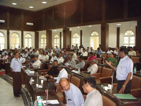
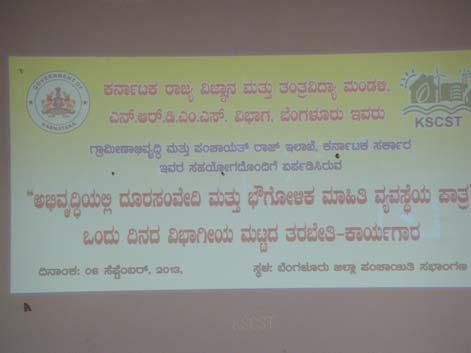
9 Program Schedule Divisional Level Training-Workshop on Application of Remote Sensing and GIS for Governance Time Program Details am Registration am Inauguration am Introduction to the training Workshop am About Karnataka State Council for Science and Technology pm Basics of GIS and Remote Sensing pm a. Introduction to NRDMS Program b. Introduction to Maps and Data and Geospatial Technologies for Governance pm Lunch pm a. Crowd Sourcing and its demonstration b. Presentation by District Project personnel pm Laser scanning & 3D Modeling of heritage sites and restoration of Kalyanies pm Discussion and Interaction Divisional training-workshop Division Date Officers Participation Belgaum 13 August Mysore 23 August Bangalore 06 September Gulbarga 20 September


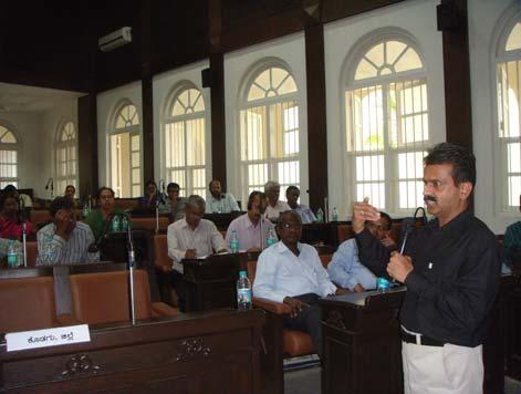
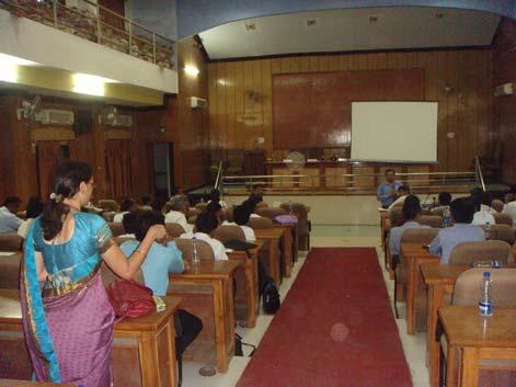
10 Belgaum Division workshop

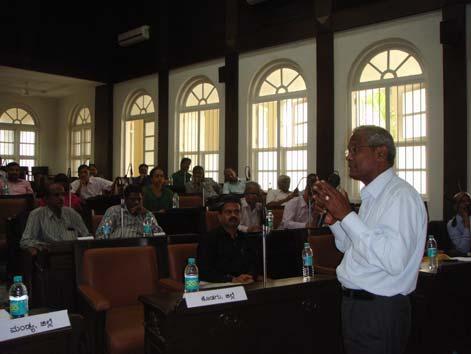
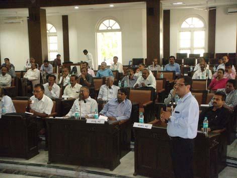
11 M Mysore Division workshop

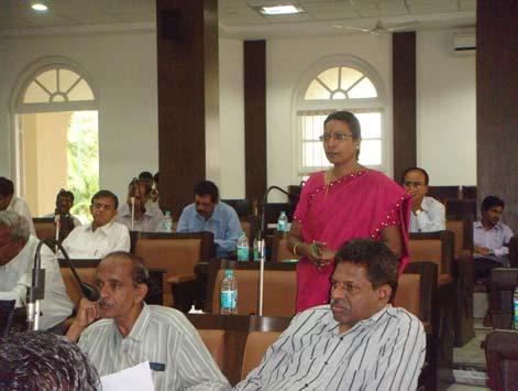
12 Bangalore Division workshop

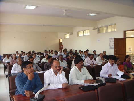
13 Gulbarga Division workshop

14
15 NATURAL RESOURCES DATA MANAGEMENT SYSTEM PROGRAM DISTRICT NRDMS CENTRE - TECHNICAL STAFF NAME DISTRICT NAME NAME DISTRICT NAME Mr. Manjunath S Totad Belgaum Mr. Girish Kumar P Chickmagalur Mr. Chandrashekhar K Gund Bidar Mr. Sandeep S Patil Gulbarga Mrs. Pratibha V Hubballi Dharwad Smt. Mamatha K S Dakshina Kannada Mr. Karthik M S Chamarajanagar Mr. Omkar Kori Gadag Mr. Shankar P Shimoga Mrs. Shruthi M N Tumkur Mr. Chandrashekhar T Chitradurga Mr. Kiran Raj K Madikeri Mr. Shrikanth Y Pujari Bagalkot Mr. Niranjan Kumar R Kolar Mr. Gangadharappa R Davangere Mr. Mohammad Farook Ali Raichur Mr. Pradeep V Hegde Haveri Mr. Manjula R Chandugol Chickballapur Mr. Pradeep Kumar B M Mandya Mr. Vinodha M Ramanagara Mr. Ramachandra Reddy G B Bellary Mr. Vikram R Udupi Mr. Kethan Kumar P Bijapur Mr. R Siddha Reddy Yadgir Mr. Guruswamy P Koppal Mr. D. Akshaya Mysore SENIOR DISTRICT SENIOR STATE CENTRE Mr. H.R. Phalanetra Hassan Mr. S.N. Sondur Mr. U.T. Vijay Mr. D.R. Ramesh Bangalore Rural STATE NRDMS CELL Mr. K.V. Shivakumar Bangalore (U) Mr. Rathan Raj M.J. Smt. Smitha M.J. Mr. Anil R Naik Uttara Kannada Mr. Umesh V.Ghatage Mr. Mohan Kumar S. Mr. Anil Kumar M. Mr. Arjun Kumar P.
ESTABLISHMENT OF KARNATAKA GEOPORTAL AND ITS ROLE IN PLANNING
 ESTABLISHMENT OF KARNATAKA GEOPORTAL AND ITS ROLE IN PLANNING By H. Hemanth Kumar Karnataka State Council for Science & Technology (KSCST), Indian Institute of Science, Bangalore, India Abstract Natural
Development of Karnataka State Geoportal
 Development of Karnataka State Geoportal H Hemanth Kumar KSCST, Bangalore 12. hemanth.h.kumar@gmail.com hemanth@kscst.iisc.ernet.in 1 DEVELOPMENT OF KARNATAKA STATE SPATIAL DATA INFRASTRUCTURE (KSSDI)
KARNATAKA STATE NATURAL DISASTER MONITORING CENTRE (An Autonomous Body, affiliated to Department of Revenue, Govt. of Karnataka)
") balla WEATHER: KARNATAKA STATE NATURAL DISASTER MONITORING CENTRE (An Autonomous Body, affiliated to Department of Revenue, Govt. of Karnataka) DAILY REPORT DATED 29.08.2016 Weather in the State during
balla WEATHER: KARNATAKA STATE NATURAL DISASTER MONITORING CENTRE (An Autonomous Body, affiliated to Department of Revenue, Govt. of Karnataka) DAILY REPORT DATED 29.08.2016 Weather in the State during
IV. RESULTS AND DISCUSSION
 Crowd sourcing (Authoritative) of Geographic Information on Public Assets and Amenities H. Hemanth Kumar, Dr. M. Prithviraj, M. J Rathan Raj, Umesh Ghatage and Mohan Kumar. S Karnataka State Council for
Karnataka GIS. Preview of K-GIS Components, Status, Policies, Opportunities, Challenges and Vision M.JAYACHANDRAN. KGIS - Mission Management
 Karnataka GIS Preview of K-GIS Components, Status, Policies, Opportunities, Challenges and Vision BY M.JAYACHANDRAN KGIS - Mission Management Karnataka State Remote Sensing Applications Center, GoK 18-Jan-2018
Abstract. I. Introduction
 ECONOPHYSICS MODEL FOR THE MIGRATION: A Case of Karnataka M.N. Megeri* and Manoj kumar. G** Abstract Population movement is an essential part for development of any region or country and one of the most
Global Geospatial Information Management Country Report Finland. Submitted by Director General Jarmo Ratia, National Land Survey
 Global Geospatial Information Management Country Report Finland Submitted by Director General Jarmo Ratia, National Land Survey Global Geospatial Information Management Country Report Finland Background
ANNUAL REPORT ON THE REGISTRATION OF BIRTHS AND DEATHS ACT,
 DES No. 8 of 2014 GOVERNMENT OF KARNATAKA ANNUAL REPORT ON THE REGISTRATION OF BIRTHS AND DEATHS ACT, 1969 2012 OFFICE OF THE CHIEF REGISTRAR OF BIRTHS & DEATHS AND DIRECTORATE OF ECONOMICS & STATISTICS
Research Perspective URBANISATION IN KARNATAKA: TREND AND SPATIAL PATTERN
 Journal of Regional Development and Planning, Vol. 7, No.1, 2018 61 Research Perspective URBANISATION IN KARNATAKA: TREND AND SPATIAL PATTERN Meghana Eswar 1 and Archana K Roy 2 Karnataka is the seventh
Development of Geospatial Information in Indonesia: Progress & Challenge
 Development of Geospatial Information in Indonesia: Progress & Challenge Dr. Nurwadjedi Sarbini Deputy of Thematic Geospatial Information Geospatial Information Agency (BIG) Geosmart Asia, September 29
KERALA STATE LAND USE BOARD TECHNICAL SUPPORT ORGANISATION
 KERALA STATE LAND USE BOARD TECHNICAL SUPPORT ORGANISATION Kerala State Land Use Board was established in 1975 under Department of Planning and Economic Affairs, Government of Kerala and is functioning
VENUS INTERNATIONAL COLLEGE OF TECHNOLOGY
 VENUS INTERNATIONAL COLLEGE OF TECHNOLOGY DEPARTMENT OF E&C ENGINEERING A REPORT ON INDUSTRIAL VISIT AT BISAG, GANDHINAGAR PROFILE: BISAG provides specialized services and solutions in implementing mapbased
An Internet-Based Integrated Resource Management System (IRMS)
") An Internet-Based Integrated Resource Management System (IRMS) Third Quarter Report, Year II 4/1/2000 6/30/2000 Prepared for Missouri Department of Natural Resources Missouri Department of Conservation
An Internet-Based Integrated Resource Management System (IRMS) Third Quarter Report, Year II 4/1/2000 6/30/2000 Prepared for Missouri Department of Natural Resources Missouri Department of Conservation
National GIS Platform for Digital India. Dr.(Mrs.) Vandana Sharma Deputy Director General National Informatics Centre
 Vandana Sharma Deputy Director General National Informatics Centre") National GIS Platform for Digital India Dr.(Mrs.) Vandana Sharma Deputy Director General National Informatics Centre sharma.vandana@nic.in NIC DEITY - National e-governance Infrastructure Meghraj Cloud
National GIS Platform for Digital India Dr.(Mrs.) Vandana Sharma Deputy Director General National Informatics Centre sharma.vandana@nic.in NIC DEITY - National e-governance Infrastructure Meghraj Cloud
Brazil Paper for the. Second Preparatory Meeting of the Proposed United Nations Committee of Experts on Global Geographic Information Management
 Brazil Paper for the Second Preparatory Meeting of the Proposed United Nations Committee of Experts on Global Geographic Information Management on Data Integration Introduction The quick development of
Economic and Social Council
 United Nation E/C.20/2012/4/Add.1 Economic and Social Council Distr.: General 2 July 2012 Original: English Committee of Experts on Global Geospatial Information Management Second session New York, 13-15
Statewide Topographic Mapping Program
 Statewide Topographic Mapping Program February 28, 2018 www.dotd.la.gov Outline Purpose of the Statewide Topographic Mapping Program History Breakdown of R.S. 48:36 - Topographic Mapping Statewide Topographic
UNITED NATIONS E/CONF.96/CRP. 5
 UNITED NATIONS E/CONF.96/CRP. 5 ECONOMIC AND SOCIAL COUNCIL Eighth United Nations Regional Cartographic Conference for the Americas New York, 27 June -1 July 2005 Item 5 of the provisional agenda* COUNTRY
Georeferencing and Satellite Image Support: Lessons learned, Challenges and Opportunities
 Georeferencing and Satellite Image Support: Lessons learned, Challenges and Opportunities Shirish Ravan shirish.ravan@unoosa.org UN-SPIDER United Nations Office for Outer Space Affairs (UNOOSA) UN-SPIDER
Excel Geomatics: Offering Excellence with Unique Consultancy & Services
 Excel Geomatics: Offering Excellence with Unique Consultancy & Services Providing consultancy and value Added Services using Remote Sensing, Photogrammetry and LiDAR in areas such as Agriculture, Forestry,
Conference at a Glance
 Conference at a Glance 8:30 AM MONDAY ROOM 333 ROOM 327/328 ROOM 238 ROOM 296/298 WELCOME and KEYNOTE SPEAKER MICHAEL MILASKA 10 AM BREAK 10:30 AM Web Applications I 12 PM 1:30 PM Intro to R Data Science
Web GIS Based Disaster Portal Project ESRI INDIA
 Web GIS Based Disaster Portal Project ESRI INDIA Contents Requirements Overview Product Technology Used KSNDMC Application Architecture Tool Developed Benefits for the End User Problems faced during implementation
GEO Geohazards Community of Practice
 GEO Geohazards Community of Practice 1) Co-Chair of GHCP With input from: Stuart Marsh, GHCP Co-Chair Francesco Gaetani, GEO Secretariat and many GHCP contributors 1) Nevada Bureau of Mines and Geology
Statement (India) at the 1 st High Level Forum Meeting of United Nations Global Geospatial Information Management held at Seoul on 24 th October 2011
 at the 1 st High Level Forum Meeting of United Nations Global Geospatial Information Management held at Seoul on 24 th October 2011") Statement (India) at the 1 st High Level Forum Meeting of United Nations Global Geospatial Information Management held at Seoul on 24 th October 2011 T Ramasami, Secretary to The Government of India, Ministry
Statement (India) at the 1 st High Level Forum Meeting of United Nations Global Geospatial Information Management held at Seoul on 24 th October 2011 T Ramasami, Secretary to The Government of India, Ministry
Fish Pond. Old Secretariate. Shaheed Smarak
 Fish Pond Old Secretariate Shaheed Smarak HOW SATELLITE SCANS EARTH. Rajbhawan area viewed by IKONOS 1 meter sensor Very high resolution (40 cm) Orbi-Image data Higher the resolution better the geometric
MALDIVES. Regional Expert Workshop On Land Accounting For SDG Monitoring & Reporting (25-27 th Sept 2017) - Fathimath Shanna, Aishath Aniya -
 - Fathimath Shanna, Aishath Aniya -") MALDIVES Regional Expert Workshop On Land Accounting For SDG Monitoring & Reporting (25-27 th Sept 2017) - Fathimath Shanna, Aishath Aniya - ABOUT MALDIVES Approximately 860 km long and 120 km wide Consists
MALDIVES Regional Expert Workshop On Land Accounting For SDG Monitoring & Reporting (25-27 th Sept 2017) - Fathimath Shanna, Aishath Aniya - ABOUT MALDIVES Approximately 860 km long and 120 km wide Consists
KUNMING FORUM ON UNITED NATIONS GLOBAL GEOSPATIAL INFORMATION MANAGEMENT CITIES OF THE FUTURE: SMART, RESILIENT
 KUNMING FORUM ON UNITED NATIONS GLOBAL GEOSPATIAL INFORMATION MANAGEMENT CITIES OF THE FUTURE: SMART, RESILIENT and SUSTAINABLE Yunnan Zhenzhuang Guest House, Kunming, China 10 12 May 2017 BACKGROUND CONCEPT
GIS for the Beginner on a Budget
 GIS for the Beginner on a Budget Andre C. Bally, RLA, GIS Coordinator, Harris County Public Infrastructure Department Engineering Division This presentation, GIS for Beginners on a Budget. will briefly
Presented to Sub-regional workshop on integration of administrative data, big data and geospatial information for the compilation of SDG indicators
 Presented to Sub-regional workshop on integration of administrative data, big data and geospatial information for the compilation of SDG indicators 23-25 April,2018 Addis Ababa, Ethiopia By: Deogratius
European Location Framework data in the ArcGIS platform
 European Location Framework data in the ArcGIS platform Presentation to: Author: Date: INSPIRE Conference 2016 Clemens Portele 26 September 2016 Why ELF? Global (e.g. UN GGIM) Regional Europe (INSPIRE
CHAPTER 22 GEOGRAPHIC INFORMATION SYSTEMS
 CHAPTER 22 GEOGRAPHIC INFORMATION SYSTEMS PURPOSE: This chapter establishes the administration and use of to improve the quality and accessibility of Department s spatial information and support graphical
Capacity Building Programme
 Capacity Building Programme 14-17 August 2012 Space Technology for improving Hazard Mapping in Sri Lanka An event organised as a follow up of the UN-SPIDER Technical Advisory Mission to Sri Lanka - 17-21
GIS at UCAR. The evolution of NCAR s GIS Initiative. Olga Wilhelmi ESIG-NCAR Unidata Workshop 24 June, 2003
 GIS at UCAR The evolution of NCAR s GIS Initiative Olga Wilhelmi ESIG-NCAR Unidata Workshop 24 June, 2003 Why GIS? z z z z More questions about various climatological, meteorological, hydrological and
Economic and Social Council
 United Nations Economic and Social Council Distr.: General 23 May 2012 Original: English E/CONF.101/100 Tenth United Nations Conference on the Standardization of Geographical Names New York, 31 July 9
Esri and GIS Education
 Esri and GIS Education Organizations Esri Users 1,200 National Government Agencies 11,500 States & Regional Agencies 30,800 Cities & Local Governments 32,000 Businesses 8,500 Utilities 12,600 NGOs 11,000
The Role of Urban Planning and Local SDI Development in a Spatially Enabled Government. Faisal Qureishi
 The Role of Urban Planning and Local SDI Development in a Spatially Enabled Government Faisal Qureishi 1 Introduction A continuous increase in world population combined with limited resources has lead
CSIR-Central Building Research Institute, Roorkee (UK)
") CSIR-Central Building Research Institute, Roorkee (UK) Introduction: Training programme on Control Measures for Landslides held during July 18-22, 2016 Landslides problem in hilly terrains are one of the
CSIR-Central Building Research Institute, Roorkee (UK) Introduction: Training programme on Control Measures for Landslides held during July 18-22, 2016 Landslides problem in hilly terrains are one of the
Spatial Data Availability Energizes Florida s Citizens
 NASCIO 2016 Recognition Awards Nomination Spatial Data Availability Energizes Florida s Citizens State of Florida Agency for State Technology & Department of Environmental Protection Category: ICT Innovations
Establishing the National Spatial Data Infrastructure (NSDI) for Norway a joint effort by many stakeholders SPATIAL DATA FOR BENEFIT OF THE SOCIETY
 for Norway a joint effort by many stakeholders SPATIAL DATA FOR BENEFIT OF THE SOCIETY") Establishing the National Spatial Data Infrastructure (NSDI) for Norway a joint effort by many stakeholders SPATIAL DATA FOR THE BENEFIT OF SOCIETY OUTLINE Political background Norway digital - The Norwegian
Establishing the National Spatial Data Infrastructure (NSDI) for Norway a joint effort by many stakeholders SPATIAL DATA FOR THE BENEFIT OF SOCIETY OUTLINE Political background Norway digital - The Norwegian
GEOGRAPHIC INFORMATION SYSTEMS Session 8
 GEOGRAPHIC INFORMATION SYSTEMS Session 8 Introduction Geography underpins all activities associated with a census Census geography is essential to plan and manage fieldwork as well as to report results
Voices from Private Sector: Insights for Future NSDI Development in Indonesia
 Voices from Private Sector: Insights for Future NSDI Development in Indonesia Ta n d a n g Yu l i a d i D w i P u t ra, Ryosuke S h i b a s a k i I n st i t u t e o f I n d u st r i a l S c i e n c e,
Developing a Community Geographical Information System (GIS) in Rural India
 in Rural India") Developing a Community Geographical Information System (GIS) in Rural India Before rushing off and describing the unique challenges of developing a small scale GIS system India I better first describe
Developing a Community Geographical Information System (GIS) in Rural India Before rushing off and describing the unique challenges of developing a small scale GIS system India I better first describe
Economic and Social Council
 United Nations Economic and Social Council Distr.: General 2 July 2012 E/C.20/2012/10/Add.1 Original: English Committee of Experts on Global Geospatial Information Management Second session New York, 13-15
INSPIRE - A Legal framework for environmental and land administration data in Europe
 INSPIRE - A Legal framework for environmental and land administration data in Europe Dr. Markus Seifert Bavarian Administration for Surveying and Cadastre Head of the SDI Office Bavaria Delegate of Germany
Status of implementation of the INSPIRE Directive 2016 Country Fiches. COUNTRY FICHE Malta
 Status of implementation of the INSPIRE Directive 2016 Country Fiches COUNTRY FICHE Malta Introduction... 1 1. State of Play... 2 1.1 Coordination... 2 1.2 Functioning and coordination of the infrastructure...
Disaster Management in Mongolia
 The Third UN-GGIM-AP Plenary Meeting Disaster Management in Mongolia ~Coordination among NGIA & Other Related Organizations and Recommendations~ Bali Indonesia 10 November 2014 Khurelshagai Ayurzana, Director
National Public Weather and Warning Services in the Swaziland Meteorological Service Dennis S.Mkhonta /
 National Public Weather and Warning Services in the Swaziland Meteorological Service Dennis S.Mkhonta dennis.mkhonta@gmail.com / dennis@swazimet.gov.sz Introduction Swaziland s geographical position exposes
INSPIRE Basics. Vlado Cetl European Commission Joint Research Centre. https://ec.europa.eu/jrc/
 INSPIRE Basics Vlado Cetl European Commission Joint Research Centre https://ec.europa.eu/jrc/ Serving society Stimulating innovation Supporting legislation Outline SDI? Why European SDI? INSPIRE Policy
Corporate. Information. Railway Infrastructure Administrator. Year indracompany.com
 geospatial and mobility Corporate Geographic Information System of ADIF Railway Infrastructure Administrator. Year 2009-2010 Corporate Geographic Information System of ADIF ADIF. Spanish Administrator
The Canadian Ceoscience Knowledge Network. - A Collaborative Effort for Unified Access to Ceoscience Data
 The Canadian Ceoscience Knowledge Network - A Collaborative Effort for Unified Access to Ceoscience Data The Canadian Geoscience Knowledge Network A Collaborative Effort for Unified Access to Geoscience
OREGON POPULATION FORECAST PROGRAM
 OREGON POPULATION FORECAST PROGRAM PROGRAM OVERVIEW BACKGROUND Beginning in 1973 with the passage of Senate Bill (SB) 100, Oregon s growth management system has relied on population forecasts as the primary
CLICK HERE TO KNOW MORE
 CLICK HERE TO KNOW MORE Geoinformatics Applications in Land Resources Management G.P. Obi Reddy National Bureau of Soil Survey & Land Use Planning Indian Council of Agricultural Research Amravati Road,
8 th Arctic Regional Hydrographic Commission Meeting September 2018, Longyearbyen, Svalbard Norway
 8 th Arctic Regional Hydrographic Commission Meeting 11-13 September 2018, Longyearbyen, Svalbard Norway Status Report of the Arctic Regional Marine Spatial Data Infrastructures Working Group (ARMSDIWG)
Key Points Sharing fosters participation and collaboration Metadata has a big role in sharing Sharing is not always easy
 Sharing Resources Geoff Mortson esri, Inc. SDI Solutions Team Key Points Sharing fosters participation and collaboration Metadata has a big role in sharing Sharing is not always easy Data Sharing is Good
Geographical Names: Detailing Map and Enhancing GIS
 Geographical Names: Detailing Map and Enhancing GIS Zainal A MAJEED, MALAYSIA Keywords: geographical names, GIS, geographic name standardization, toponymy SUMMARY The necessity of having geographical names
INDONESIA S S UPDATE: GEOSPATIAL INFORMATION FOR SUSTAINABLE DEVELOPMENT RELATED TO INA SDI Dr. Asep Karsidi, M.Sc
 INDONESIA S S UPDATE: GEOSPATIAL INFORMATION FOR SUSTAINABLE DEVELOPMENT RELATED TO INA SDI Dr. Asep Karsidi, M.Sc GEOSPATIAL INFORMATION AGENCY 08 August, 2012 OUTLINE 1. Transformation Bakosurtanal into
2007 / 2008 GeoNOVA Secretariat Annual Report
 2007 / 2008 GeoNOVA Secretariat Annual Report Prepared for: Assistant Deputy Minister and Deputy Minister of Service Nova Scotia and Municipal Relations BACKGROUND This report reflects GeoNOVA s ongoing
The purpose of this report is to recommend a Geographic Information System (GIS) Strategy for the Town of Richmond Hill.
 Strategy for the Town of Richmond Hill.") Staff Report for Committee of the Whole Meeting Department: Division: Subject: Office of the Chief Administrative Officer Strategic Initiatives SRCAO.18.12 GIS Strategy Purpose: The purpose of this report
Staff Report for Committee of the Whole Meeting Department: Division: Subject: Office of the Chief Administrative Officer Strategic Initiatives SRCAO.18.12 GIS Strategy Purpose: The purpose of this report
INSPIRing Geospatial Framework For Local Administrations
 This project is financed by the European Union and the Republic of Turkey Presented at the FIG Congress 2018, May 6-11, 2018 in Istanbul, Turkey National Programme for Turkey 2010 Instrument for Pre-Accession
Esri India User Conference
 Esri India User Conference The Leela Ambience Convention Hotel, Delhi January 19 20, 2017 Keynote Speaker Jack Dangermond Founder and President, Esri Inc. Register Today esriindia.com/indiauc About Esri
Introducing SIMON Sefton Interactive Maps ONline
 Cadcorp Local Government Conference Thursday 23 rd March 2017 Introducing SIMON Sefton Interactive Maps ONline www.sefton.gov.uk Introduction Chris Nelson - Technical Officer, Planning Services SIMON and
Economic and Social Council 2 July 2015
 ADVANCE UNEDITED VERSION UNITED NATIONS E/C.20/2015/11/Add.1 Economic and Social Council 2 July 2015 Committee of Experts on Global Geospatial Information Management Fifth session New York, 5-7 August
Overview of Technical Advisory Missions
 Expert Group Meeting (EGM) on Georeferenced Information Systems for Disaster Risk Management (Geo-DRM) and sustaining the Community of Practice (COP) 23-25 April 2014 Bangkok Overview of Technical Advisory
SOLUTIONS ADVANCED GIS. TekMindz are developing innovative solutions that integrate geographic information with niche business applications.
 ADVANCED GIS SOLUTIONS TekMindz are developing innovative solutions that integrate geographic information with niche business applications. TEK INDZ TM GIS Services Overview At the leading edge of geospatial
Integrated Geodatabase Model for effective planning of District -Hamirpur
 Integrated Geodatabase Model for effective planning of District -Hamirpur Developed by District Administration,Hamirpur in collaboration with Centre for Geoinformatics Research and Training, CSK HPAU,Palampur
Concept Formulation of Geospatial Infrastructure. Hidenori FUJIMURA*
 Concept Formulation of Geospatial Infrastructure 1 Concept Formulation of Geospatial Infrastructure Hidenori FUJIMURA* (Published online: 28 December 2016) Abstract Technical trends in the field of surveying
GEONETCast Future Plans at CIMH
 GEONETCast Future Plans at CIMH Operations, Training, Climate Monitoring and Disaster Preparedness WORLD METEOROLOGICAL ORGANIZATION COORDINATION GROUP ON SATELLITE DATA REQUIREMENTS FOR REGION III AND
Challenges and Potentials of Place Based Information Management in Nepal"
 Nineteenth United Nations Regional Cartographic Conference for Asia and the Pacific, Bangkok, Thailand, 29 October 1 November 2012 Challenges and Potentials of Place Based Information Management in Nepal"
Turkey s National SDI Implementation
 Onur PAŞAOĞULLARI Head of Department Turkey s National SDI Implementation Presentation Plan NSDI Background General Directorate of Geographic Information Systems NSDI Project INSPIRE Directive Urban Information
Spatially Enabled Society
 International Seminar on Land Administration Trends and Issues in Asia and the Pacific Region Spatially Enabled Society Abbas Rajabifard Vice Chair PCGIAP-WG3 Vice-President (President Elect), GSDI Association
THAILAND NSDI DVELOPMENT PROGRAM: ThaiSDI
 THAILAND NSDI DVELOPMENT PROGRAM: ThaiSDI Dr.Chaowalit Silapathong Director of Geo-informatics Office Geo-Informatics and Space Technology Development Agency (Public Organization): GISTDA chaow@gistda.or.th
Land Board, NW Services and SDI Tambet Tiits, FRICS
 Land Board, NW Services and SDI Tambet Tiits, FRICS 07.09.2016 200th anniversary of the Struve Geodetic Arc Friedrich Georg Wilhelm Struve and Carl Friedrich Tenner Struve Geodetic Arc The Struve Geodetic
GIS Building Communities beyond National Borders (Building Successful Spatial Data Infrastructures) Nick Land, ESRI Europe
 Nick Land, ESRI Europe") GIS Building Communities beyond National Borders (Building Successful Spatial Data Infrastructures) Nick Land, ESRI Europe UK worst flooding in the last 60 years 350,000 households without drinking water
GIS Building Communities beyond National Borders (Building Successful Spatial Data Infrastructures) Nick Land, ESRI Europe UK worst flooding in the last 60 years 350,000 households without drinking water
Press Release: First WMO Workshop on Operational Climate Prediction
 Press Release: First WMO Workshop on Operational Climate Prediction a) b) c) d) Photographs during the first WMO Workshop on Operational Climate Prediction: a) Group Photograph, b) Dr M. Rajeevan, Director,
Bio-data. Degree Specialization Year of passing/class University
 Bio-data Dr.Nandeesha Pofessor Department of Civil Engineering, Siddaganga Institute of Technology, B. H. Road, Tumkur, India Contact Information: (I) EDUCATIONAL QUALIFICATIONS Tel : 08162214027 (O) Mob.
Science Academy s Lecture Workshop on Spectroscopic Techniques and Applications in Material Characterization-(STAMC-2016)
") Science Academy s Lecture Workshop on Spectroscopic Techniques and Applications in Material Characterization-(STAMC-2016) Aim of the work shop: To enhance the knowledge of the students, teachers and research
Science Academy s Lecture Workshop on Spectroscopic Techniques and Applications in Material Characterization-(STAMC-2016) Aim of the work shop: To enhance the knowledge of the students, teachers and research
UN GGIM and National SDI Strategy
 MSDI Open Forum on 26 th January 2016 Contributing to the successful delivery of MSDI UN GGIM and National SDI Strategy Hiroshi Murakami Deputy Administrator Geospatial Information Authority of Japan Geospatial
Progress Report. Flood Hazard Mapping in Thailand
 Progress Report Flood Hazard Mapping in Thailand Prepared By: Mr. PAITOON NAKTAE Chief of Safety Standard sub-beuro Disaster Prevention beuro Department of Disaster Prevention and Mitigation THAILAND E-mail:
ADDRESSING THE DATA AND INFORMATION NEEDS FOR GOOD GOVERNANCE, SHARING EXPERIENCES FROM COTE D IVOIRE. 20 April 2016 to 22 April 2016 ADDIS ABABA
 20 April 2016 to 22 April 2016 ADDIS ABABA ADDRESSING THE DATA AND INFORMATION NEEDS FOR GOOD GOVERNANCE, SHARING EXPERIENCES FROM COTE D IVOIRE Dr. Edouard FONH-GBEI Director General of CNTIG, General
No. of Days. Building 3D cities Using Esri City Engine ,859. Creating & Analyzing Surfaces Using ArcGIS Spatial Analyst 1 7 3,139
 Q3 What s New? Creating and Editing Data with ArcGIS Pro Editing and Maintaining Parcels Using ArcGIS Spatial Analysis Using ArcGIS Pro User Workflows for ArcGIS Online Organizations Q3-2018 ArcGIS Desktop
THE 3D SIMULATION INFORMATION SYSTEM FOR ASSESSING THE FLOODING LOST IN KEELUNG RIVER BASIN
 THE 3D SIMULATION INFORMATION SYSTEM FOR ASSESSING THE FLOODING LOST IN KEELUNG RIVER BASIN Kuo-Chung Wen *, Tsung-Hsing Huang ** * Associate Professor, Chinese Culture University, Taipei **Master, Chinese
Short Term Course GEOINFORMATION SCIENCE AND TECHNOLOGY REMOTE SENSING, GPS, & GIS APPLICATIONS. Duration: 20 Weeks Two Batches in an year
 Short Term Course on GEOINFORMATION SCIENCE AND TECHNOLOGY REMOTE SENSING, GPS, & GIS APPLICATIONS Duration: 20 Weeks Two Batches in an year Information Brochure Dr. R. Satheesh Centre for Remote Sensing
Building Institutional Capacity for Multi-Hazard Early Warning in Asia and the Pacific Subtitle
 Building Institutional Capacity for Multi-Hazard Early Warning in Asia and the Pacific Subtitle Title Keran Wang Chief, Space Applications Section ICT and Disaster Risk Reduction Division 22 May 2018 Pillar
GEOMATICS. Shaping our world. A company of
 GEOMATICS Shaping our world A company of OUR EXPERTISE Geomatics Geomatics plays a mayor role in hydropower, land and water resources, urban development, transport & mobility, renewable energy, and infrastructure
12. INDUSTRIES 12.1 REGISTERED FACTORIES BY INDUSTRIES (Numbers) NIC Group
 NIC Group") 12. INDUSTRIES 12.1 REGISTERED FACTORIES BY INDUSTRIES (Numbers) NIC Group Description 2011-12 2012-13 2013-14 2008 1 2 3 4 5 1 Cotton Ginning, Cleaning & Baling 326 358 358 11 Manufacture of Food Products
12. INDUSTRIES 12.1 REGISTERED FACTORIES BY INDUSTRIES (Numbers) NIC Group Description 2011-12 2012-13 2013-14 2008 1 2 3 4 5 1 Cotton Ginning, Cleaning & Baling 326 358 358 11 Manufacture of Food Products
Aboriginal communities strengthen governance with location-based tools in the 21st century
 Aboriginal communities strengthen governance with location-based tools in the 21st century Today, Aboriginal communities are taking advantage of the geomatics technologies that underpin popular online
SDI Development in Georgia. Mari Khardziani Head of International Relations Unit National Agency of Public Registry
 SDI Development in Georgia Mari Khardziani Head of International Relations Unit National Agency of Public Registry Kehl, Germany September 5, 2017 2 National Agency of Public Registry Legal Entity of Public
RETA 6422: Mainstreaming Environment for Poverty Reduction Category 2 Subproject
 RETA 6422: Mainstreaming Environment for Poverty Reduction Category 2 Subproject A. Basic Data 1. Subproject Title: Poverty-Environment Mapping to Support Decision Making 2. Country Director: Adrian Ruthenberg
UN-GGIM: Strengthening Geospatial Capability
 Fifth Plenary Meeting of UN-GGIM: Europe Brussels, 6-7 June 2018 UN-GGIM: Strengthening Geospatial Capability Walking the talk to leave no one behind Greg Scott, UN-GGIM Secretariat Environmental Statistics
for Effective Land Administration
 Role of Geospatial Technology in Land Information System(LIS) for Effective Land Administration Dr. Deb Jyoti Pal Sections Role of GIS in Land Records Proposed Work Flow Case Studies Role of GIS Creating
Ministry of ICT of I.R.IRAN
 The ECO 8/6 mill km 2 10 Slamic countries ~330 mill people Oil, Gas, Industries,Tourism 2 Issue transformation in last decade Problem solving needs more integrated approach More interaction &complexity
Towards National Geographic Information System in Nepal
 2 nd High Level Forum on Global Geospatial Information Management, Qatar National Convention Centre, Doha, Qatar, 4 6 February, 2013 Towards National Geographic Information System in Nepal Krishna Raj
Geospatial SDI Portal for effective Governance of Pune METROPOLIS region
 Geospatial SDI Portal for effective Governance of Pune METROPOLIS region Mr. Praveen Gautam Senior Manager 19 th January 2018 PMRDA Overview Provide a Spatial Framework for the entire region with various
Report of the Regional Committee of UN-GGIM for Asia and the Pacific (UN-GGIM-AP)
") Report of the Regional Committee of UN-GGIM for Asia and the Pacific (UN-GGIM-AP) At the Eighth Session of UN-GGIM UN Headquarters, New York, 1 3 August 2018 About UN-GGIM-AP One of the five regional committees
Report of the Regional Committee of UN-GGIM for Asia and the Pacific (UN-GGIM-AP) At the Eighth Session of UN-GGIM UN Headquarters, New York, 1 3 August 2018 About UN-GGIM-AP One of the five regional committees
Techniques for Science Teachers: Using GIS in Science Classrooms.
 Techniques for Science Teachers: Using GIS in Science Classrooms. After ESRI, 2008 GIS A Geographic Information System A collection of computer hardware, software, and geographic data used together for
Economic and Social Council
 United Nations Economic and Social Council Distr.: General 18 July 2016 Original: English Committee of Experts on Global Geospatial Information Management Sixth session New York, 3-5 August 2016 Item 2
UN COMMITTEE OF EXPERTSON GLOBAL GEOSPATIAL INFORMATION MANAGEMENT. August 13 15, 2012 COUNTRY REPORT OF THE PHILIPPINES
 UN COMMITTEE OF EXPERTSON GLOBAL GEOSPATIAL INFORMATION MANAGEMENT August 13 15, 2012 COUNTRY REPORT OF THE PHILIPPINES National Mapping and Resource Information Authority Department of Environment and
Data Aggregation with InfraWorks and ArcGIS for Visualization, Analysis, and Planning
 Data Aggregation with InfraWorks and ArcGIS for Visualization, Analysis, and Planning Stephen Brockwell President, Brockwell IT Consulting, Inc. Join the conversation #AU2017 KEYWORD Class Summary Silos
Global Challenges And Indian Initiatives *
 HIGH LEVEL FORUM ON GLOBAL GEOSPATIAL MANAGEMENT INFORMATION WORKING PAPER No. 15 First Forum Seoul, Republic of Korea, 24-26 October 2011 Global Challenges And Indian Initiatives * * Submitted by: Mr.
Country Report Nepal Geospatial Data Sharing Initiatives of Survey Department Supporting Disaster Management
 Third JPTM Step 2 for Sentinel Asia 6-8 July, 2010 Manila, The Philippines Country Report Nepal Geospatial Data Sharing Initiatives of Survey Department Supporting Disaster Management Durgendra M Kayastha