Web GIS Based Disaster Portal Project ESRI INDIA
|
|
|
- Lee Reeves
- 5 years ago
- Views:
Transcription


1 Web GIS Based Disaster Portal Project ESRI INDIA
2 Contents Requirements Overview Product Technology Used KSNDMC Application Architecture Tool Developed Benefits for the End User Problems faced during implementation and how it was overcome Challenges Faced during implementation Applications out reach Appreciation from KSNDMC Conclusion
3 Requirements Overview Data Model Design to receive data from the Rain Gauge and Weather Stations installed in field at 15 minutes X 24 X 7 interval. Web App for Disaster analysis Data import tools for integration with IMD, CMMACS and SAC SMS / Alert Mechanism Report & Map Generation Tools to calculate Drought Analysis and Crop Insurance
4 Product Technology Used ArcGIS Server 9.3 ArcGIS Web ADF ArcSDE 9.3 ArcGIS Desktop 9.3 Oracle 10g.NET Framework 2.0
5 Upgraded to Technology ArcGIS Server 10.2 ArcGIS JavaScript API ArcGIS Desktop 10.2 Oracle 11g.NET Framework 3.5
")
")
6 KSNDMC Rain gauges(2561) & Weather Stations(370) Network
7 KSNDMC Application Architecture


8 Functional Block Diagram of KSNDMC Application

9 Tools Developed: KSNDMC Web Application - Support basic Map functionality

10 Tools Developed: KSNDMC Web Application - Display intensity of Rain and information and rendered as graphics on Map

11 Tools Developed: KSNDMC Web Application - Support to view intensity of rain by location

12 Tools Developed: KSNDMC Web Application - Support to view weather parameters by location
13 Tools Developed: KSNDMC Web Application - Support query to view intensity of Disaster affected location by rendering Map generated on browser

14 Tools Developed: KSNDMC Web Application - Support query to perform analysis on station performance


15 Tools Developed: KSNDMC Web Application - Support query to view Alerted locations

16 Tools Developed: KSNDMC Web Application - Support to view Moisture Index maps generated through browser

17 Tools Developed: KSNDMC Web Application - Support to view Earthquake affected location on browser

18 Tools Developed: KSNDMC Web Application -

19 KSNDMC Web Application: One point access to manage Master data


20 KSNDMC Web Application: Support Data download received from Rain and weather gauge


21 KSNDMC Web Application: Support to view & manage agriculture data
22 Tools Developed: Report & Map Generation Generating interpolated maps using thiessen polygon techniques using dynamic data received from Rain and Weather Gauges installed in field Type of Maps Generated v Rainfall distribution maps v Temperature & Humidity distribution maps v Anomalies and Soil moisture index maps for drought calculation v Forecast maps

 Taluk wise Wt.Avg Rain Hobli wise Wt.")
23 Report & Map generation Architecture Get the Station wise Actual Rain Data District wise Wt.Avg Rain Calculate Weighted Average Rain Value (Based on Thiessen Polygon Method) Taluk wise Wt.Avg Rain Hobli wise Wt.Avg Rain Maps Charts Daily State Report (HTML) HTML to PDF conversion Send Mail to Users Web App

24 Tools Developed: KSNDMC Daily State Report -

25 Actual & Forecast rainfall Maps auto generated

26 Humidity & Temperature Maps auto generated
27 Forecast Maps auto generated Cloud Rainfall Fraction Forecast Forecast Map Wind Map Speed & Direction Forecast Relative Temperature Map Humidity Forecast Map Map

28 Large Screen Browser Each station current parameter value can be seen on the map. By default for every 1 minute, next map will come. User can navigate between maps using Next and Back buttons. User can pause current map.

29 Large Screen Browser User can navigate from tabular data to location on map.

30 Large Screen Browser : Relative Wind Temperature Rainfall Speed Humidity & Direction
 & Direction (Interpolated)")
31 Large Large Screen Screen Browser Browser : Wind : : Relative : Rainfall Temperature Speed Humidity (Interpolated) & Direction (Interpolated) (interpolated)
32 Batch Tools Developed KSNDMC Data download HTTP (XML) TRG Data TWS Data CMMACS Forecast SAC Forecast MAIL (Excel Sheet) IMD Forecast FTP (Excel Sheet) Weather reports Daily State Weekly State Weekly District wise Monthly State Monthly District wise Seasonal State Seasonal District wise Annual State Annual District wise SMS Daily State wise Rainfall Daily Taluk, Hobli, GP level Rainfall Daily District wise Weather Daily BBMP Rainfall SMS Daily Forecast Special Alerts (Cyclone, Flood, etc) Others Drought Maps BBMP Daily Rainfall Maps District wise Forecast Rainfall Distribution Forecast Vs Actual Maps & Table Dynamic Maps for Any Time & Date Time Series Charts (Actual Vs Normal Rainfall) Crop Insurance Rainfall Runoff Analysis

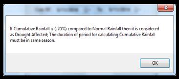
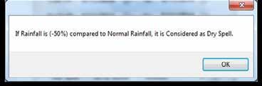
33 Drought Analysis Tool


34 Drought Maps generated for year 2013 Karnataka State Drought Map SW 2013 Chitradurga District Drought Map SW 2013


35 Generating Maps from Archived Database User has to select the Spatial Location User has to select the required Map Select Time will be Enabled User has to select the particular Date & Month between any two Years for the selected time User will enter the title of the map
 Enter the Time Duration Enter the Thresholds Enter the Rates & Maximum Payout Enter the Benchmark Rainfall/Temp Value Select the Location")
36 Crop Insurance Calculator Insurance Company Selection (ICICI, HDFC, AIC, Reliance, etc) Select the Index (Deficit RF, Excess RF, Weather Conditions) Select the number of Phases (Maximum of 5 Phases) Select the number of years of Calculation (Max of 10 Years) Enter the Time Duration Enter the Thresholds Enter the Rates & Maximum Payout Enter the Benchmark Rainfall/Temp Value Select the Location Select the Crop Type Enter Premium Export Final Payout Export for Each Phase
37 Crop Insurance Report Crop Affected due Deficit & Excess Rainfall for the past 10 Years Company District Taluk Hobli Crop Cholamandalam Bagalkote Bagalkote All Hoblis Chilli Irrigated DISTRICT TALUK HOBLI CROP COMPANY INDEX YEAR PH1 RF (mm) PH1 (rs) PH2 RF (mm) PH2 (rs) PH3 RF (mm) PH3 (rs) DEFICIT_ Total BAGALKOTE- 18 BAGALKOTE ALL HOBLIS CHILLI IRR CHOLA DEFICIT BAGALKOTE- 18 BAGALKOTE ALL HOBLIS CHILLI IRR CHOLA DEFICIT BAGALKOTE- 18 BAGALKOTE ALL HOBLIS CHILLI IRR CHOLA DEFICIT BAGALKOTE- 18 BAGALKOTE ALL HOBLIS CHILLI IRR CHOLA DEFICIT BAGALKOTE- 18 BAGALKOTE ALL HOBLIS CHILLI IRR CHOLA DEFICIT BAGALKOTE- 18 BAGALKOTE ALL HOBLIS CHILLI IRR CHOLA DEFICIT BAGALKOTE- 18 BAGALKOTE ALL HOBLIS CHILLI IRR CHOLA DEFICIT BAGALKOTE- 18 BAGALKOTE ALL HOBLIS CHILLI IRR CHOLA DEFICIT BAGALKOTE- 18 BAGALKOTE ALL HOBLIS CHILLI IRR CHOLA DEFICIT BAGALKOTE- 18 BAGALKOTE ALL HOBLIS CHILLI IRR CHOLA DEFICIT
38 Crop Insurance Report Crop Affected due Deficit & Excess Rainfall for the past 10 Years Company District Taluk Hobli Crop Cholamandalam Bagalkote Bagalkote All Hoblis Chilli Irrigated DISTRICT TALUK HOBLI CROP COMPANY INDEX YEAR PH1 PH1 ABOVE BENCHMARK BENCHMARK DAYS RF (mm) PH1 (rs) EXCESS Total BAGALKOTE-18 BAGALKOTE ALL HOBLIS CHILLI IRR CHOLA EXCESS BAGALKOTE-18 BAGALKOTE ALL HOBLIS CHILLI IRR CHOLA EXCESS BAGALKOTE-18 BAGALKOTE ALL HOBLIS CHILLI IRR CHOLA EXCESS BAGALKOTE-18 BAGALKOTE ALL HOBLIS CHILLI IRR CHOLA EXCESS BAGALKOTE-18 BAGALKOTE ALL HOBLIS CHILLI IRR CHOLA EXCESS BAGALKOTE-18 BAGALKOTE ALL HOBLIS CHILLI IRR CHOLA EXCESS BAGALKOTE-18 BAGALKOTE ALL HOBLIS CHILLI IRR CHOLA EXCESS BAGALKOTE-18 BAGALKOTE ALL HOBLIS CHILLI IRR CHOLA EXCESS BAGALKOTE-18 BAGALKOTE ALL HOBLIS CHILLI IRR CHOLA EXCESS BAGALKOTE-18 BAGALKOTE ALL HOBLIS CHILLI IRR CHOLA EXCESS
39 Crop Insurance Report Crop Affected due Deficit & Excess Rainfall for the past 10 Years YEAR YEAR_Period DEFICIT_Total EXCESS_ Total Total Company District Taluk Hobli Crop Cholamandalam Bagalkote Bagalkote All Hoblis Chilli Irrigated PERIOD TOTAL PAYOUT(RS) AVERAGE PAYOUT(RS) PREMIUM (RS) %PAYOUT TO PREMIUM Years Compared
 Enter the Title Names Select the Spatial Type Enter the Time")
40 Generating Time Series Charts from Archived Database Select Raintype (Actual / Wt Avg) Select RainValue (Daily / Season Cumulative) Enter the Title Names Select the Spatial Type Enter the Time Duration
41 Benefits for the End User An ordinary man gets the real time information instantly. Farmers get ready to face and take preliminary actions with Forecast Rainfall information. Government authorities get the Weather report on Daily, Weekly, Monthly, Seasonal and Annual basis. KSNDMC suggests the Government to issue the insurance payment for crops on Excess, Deficit Rainfall & Weather Conditions through Cropinsurance tool. KSNDMC reports to the Government about Drought affected areas. Through Weather Dash Board, common man gets the real time weather information on his finger tip (Both Spatially and temporally). KSNDMC employees are regularly monitoring, data downloading and data editing via internal portal.
42 Problems faced during implementation and how it was overcome In Web ADF, Rendering interpolated maps on browser with hatch symbol not supported due to decimal values in interpolated raster grid code values, after doing research for 20 days identified this. ArcGIS Software does not support decimal grid code values and converted grid code values to rounded values. In 10.1 ArcGIS JavaScript API, no support for rendering maps with hatch symbol type, we overcome this issue by using Picture Marker Symbol by creating picture of hatch symbol of required design and rendered on browser.
43 Challenges Faced during implementation Generating auto-mode customized alerts/early warnings/advisories based on the high density and high resolution near real-time data collected from telemetric systems of KSNDMC instead of current semi-auto mode Issue timely auto alerts/early warnings, advisories related to natural disasters to government bodies and community via SMS/help desk/ /social media/web portal Ensuring data integrity for delayed/no response TRG and TWS Building an interactive system to conveniently manage TRG and TWS stations, perform analysis, search, compare current and forecasted data. Integrating historical data with data from newly installed TRG and TWS stations

44 Applications Out Reach Daily State Weather Report send to concern Government Authorities through mail. Public can view weather information instantly through web portal ( More than people visited the website since it was developed. A Glance on Alerts issued during the Year 2013 below. SMS Type SMS Count DISTRICT Rainfall Taluk Rainfall Hobli Rainfall Gram Panchayath Regions Forecast District Forecast Taluk Forecast Hobli Forecast District Weather SMS Count 2013 (No of Users x No of SMS In a day x 365 days)
45 appreciated by client. Appreciation from KSNDMC Daily State Weather Report is Fully Automized which eliminates the Hours of Man work. The Telemetric Weather Stations (TWS) usually send 15mins interval Data. The client appreciated that the system is designed to give 1 min interval Data when the Wind speed exceeds 5 m/s. Client was very happy on development of comparison of Forecast Rainfall data with Actual Rainfall Data. (Super-impose of Actual Rain data on Forecast Rain Data). With the help of Crop Insurance tool, Client saved Hundreds of Man Hours. (Need to calculate the term sheets for 747 hoblis x 12 Crop types x 6 Companies) Rainfall Runoff Analysis done with High Intensity Rainfall Data. It pictorially depicts the runoff co-efficient per hectare per year which was well
46 Appreciation from KSNDMC KSNDMC Director well appreciated on Dynamic maps of Weather Dash Board (It dynamically updates for every 15 minutes data). TRG/TWS Monitoring system is highly helpful for the KSNDMC employees to regularly update the status of Telemetric Stations. KSNDMC appreciated the work of Internal Portal through which the users can download, update and analyze the weather data dynamically. KSNDMC Director appreciated about the migration of existing applications and database from ArcGIS to ArcGIS 10.2
47 Conclusion The KSNDMC GIS is currently in operation and has been a success story where for the first time GIS-enabled early warning and spatial decision support system for disaster management has been developed and made operational in the Indian government.

48 Questions & Discussion

49
Monitoring Extreme Weather Events. February 8, 2010
 Monitoring Extreme Weather Events February 8, 2010 Extensive network of over 800 stations across the Prairies Good coverage across entire agriculture production region Network of networks strategy includes
Correcting Real Time Automatic Weather Stations Data Through Quality Checks and Analysis
 Correcting Real Time Automatic Weather Stations Data Through Quality Checks and Analysis Sd. Thouseef Ahmed Shoaib and Syed Nayab Rasool Andhra Pradesh State Development Planning Society, Hyderabad Email:
StreamStats: Delivering Streamflow Information to the Public. By Kernell Ries
 StreamStats: Delivering Streamflow Information to the Public By Kernell Ries U.S. Department of the Interior U.S. Geological Survey MD-DE-DC District 410-238-4317 kries@usgs.gov StreamStats Web Application
Transboundary water management with Remote Sensing. Oluf Jessen DHI Head of Projects, Water Resources Technical overview
 Transboundary water management with Remote Sensing Oluf Jessen DHI Head of Projects, Water Resources Technical overview ozj@dhigroup.com Transboundary water management Water management across national
A Cotton Irrigator s Decision Support System Using National, Regional and Local Data
 A Cotton Irrigator s Decision Support System Using National, Regional and Local Data ISESS 2015, Melbourne Jamie Vleeshouwer, Nicholas J. Car, John Hornbuckle 26 March 2015 LAND & WATER FLAGSHIP / AGRICULTURE
Geodatabase Management Pathway
 Geodatabase Management Pathway Table of Contents ArcGIS Desktop II: Tools and Functionality 3 ArcGIS Desktop III: GIS Workflows and Analysis 6 Building Geodatabases 8 Data Management in the Multiuser Geodatabase
ArcGIS is Advancing. Both Contributing and Integrating many new Innovations. IoT. Smart Mapping. Smart Devices Advanced Analytics
 ArcGIS is Advancing IoT Smart Devices Advanced Analytics Smart Mapping Real-Time Faster Computing Web Services Crowdsourcing Sensor Networks Both Contributing and Integrating many new Innovations ArcGIS
Geospatial Fire Behavior Modeling App to Manage Wildfire Risk Online. Kenyatta BaRaKa Jackson US Forest Service - Consultant
 Geospatial Fire Behavior Modeling App to Manage Wildfire Risk Online Kenyatta BaRaKa Jackson US Forest Service - Consultant Fire Behavior Modeling and Forest Fuel Management Modeling Fire Behavior is an
Role of Arc GIS in developing Real Time and Forecasting Water Resource System ANMOL BHARDWAJ 1, ANIL VYAS 2 1
 Role of Arc GIS in developing Real Time and Forecasting Water Resource System ANMOL BHARDWAJ 1, ANIL VYAS 2 1 Project Associate, Indian Institute of Technology Roorkee 2 ADE National Hydrology Project,
Appendix 4 Weather. Weather Providers
 Appendix 4 Weather Using weather data in your automation solution can have many benefits. Without weather data, your home automation happens regardless of environmental conditions. Some things you can
KARNATAKA STATE NATURAL DISASTER MONITORING CENTRE (An Autonomous Body, affiliated to Department of Revenue, Govt. of Karnataka)
") balla WEATHER: KARNATAKA STATE NATURAL DISASTER MONITORING CENTRE (An Autonomous Body, affiliated to Department of Revenue, Govt. of Karnataka) DAILY REPORT DATED 29.08.2016 Weather in the State during
balla WEATHER: KARNATAKA STATE NATURAL DISASTER MONITORING CENTRE (An Autonomous Body, affiliated to Department of Revenue, Govt. of Karnataka) DAILY REPORT DATED 29.08.2016 Weather in the State during
ArcGIS Web Tools, Templates, and Solutions for Defence & Intelligence. Renee Bernstein Esri Solutions Engineer
 ArcGIS Web Tools, Templates, and Solutions for Defence & Intelligence Renee Bernstein Esri Solutions Engineer ArcGIS Solutions Includes 450+ Industry Focused Apps and Capabilities Organized by 9 Primary
Better Decisions for Your Business Drive your company forward with ultra-precise weather forecasts
 Better Decisions for Your Business Drive your company forward with ultra-precise weather forecasts Problem: Inaccurate Forecasts, Especially over Mountainous Regions Which weather data are you using? What
Gridded Ambient Air Pollutant Concentrations for Southern California, User Notes authored by Beau MacDonald, 11/28/2017
 Gridded Ambient Air Pollutant Concentrations for Southern California, 1995-2014 User Notes authored by Beau, 11/28/2017 METADATA: Each raster file contains data for one pollutant (NO2, O3, PM2.5, and PM10)
Chapter-1 Introduction
 Modeling of rainfall variability and drought assessment in Sabarmati basin, Gujarat, India Chapter-1 Introduction 1.1 General Many researchers had studied variability of rainfall at spatial as well as
SuperPack North America
 SuperPack North America Speedwell SuperPack makes available an unprecedented range of quality historical weather data, and weather data feeds for a single annual fee. SuperPack dramatically simplifies
Map Application Progression
 Map Application Progression Application Migration with Latest ArcGIS by Dean Chiang California Department of Fish and Wildlife What we do at CDFW Hunting and fishing licensing and regulation Conservation
An Online Platform for Sustainable Water Management for Ontario Sod Producers
 An Online Platform for Sustainable Water Management for Ontario Sod Producers 2014 Season Update Kyle McFadden January 30, 2015 Overview In 2014, 26 weather stations in four configurations were installed
These modules are covered with a brief information and practical in ArcGIS Software and open source software also like QGIS, ILWIS.
 Online GIS Training and training modules covered are: 1. ArcGIS, Analysis, Fundamentals and Implementation 2. ArcGIS Web Data Sharing 3. ArcGIS for Desktop 4. ArcGIS for Server These modules are covered
Simulating Future Climate Change Using A Global Climate Model
 Simulating Future Climate Change Using A Global Climate Model Introduction: (EzGCM: Web-based Version) The objective of this abridged EzGCM exercise is for you to become familiar with the steps involved
Arboretum Explorer: Using GIS to map the Arnold Arboretum
 Arboretum Explorer: Using GIS to map the Arnold Arboretum Donna Tremonte, Arnold Arboretum of Harvard University 2015 Esri User Conference (UC), July 22, 2015 http://arboretum.harvard.edu/explorer Mission
Weather versus Climate: What is the difference? Sources of Weather Information
 Joel O. Paz, Extension Agrometerologist and Gerrit Hoogenboom, Professor & REI Coordinator Department of Biological and Agricultural Engineering Weather versus Climate: What is the difference? The difference
Development of a Web-Based GIS Management System for Agricultural Authorities in Iraq
 Development of a Web-Based GIS Management System for Agricultural Authorities in Iraq USCID Water Management Conference Phoenix, Arizona April 18, 2013 Gabriele Bonaiti Extension Program Specialist David
Water Information Portal User Guide. Updated July 2014
 Water Information Portal User Guide Updated July 2014 1. ENTER THE WATER INFORMATION PORTAL Launch the Water Information Portal in your internet browser via http://www.bcogc.ca/public-zone/water-information
SOLUTIONS ADVANCED GIS. TekMindz are developing innovative solutions that integrate geographic information with niche business applications.
 ADVANCED GIS SOLUTIONS TekMindz are developing innovative solutions that integrate geographic information with niche business applications. TEK INDZ TM GIS Services Overview At the leading edge of geospatial
Website Phone Mobile OVERVIEW Davis Vantage Pro2 Weather Station
 OVERVIEW If you're looking for a superior weather station, the Davis Vantage Pro2 Weather Station is as good as they come! Vantage Pro2 offers the professional weather observer and the serious weather
Leveraging Web GIS: An Introduction to the ArcGIS portal
 Leveraging Web GIS: An Introduction to the ArcGIS portal Derek Law Product Management DLaw@esri.com Agenda Web GIS pattern Product overview Installation and deployment Configuration options Security options
Innovation. The Push and Pull at ESRI. September Kevin Daugherty Cadastral/Land Records Industry Solutions Manager
 Innovation The Push and Pull at ESRI September 2004 Kevin Daugherty Cadastral/Land Records Industry Solutions Manager The Push and The Pull The Push is the information technology that drives research and
Leveraging ArcGIS Online Elevation and Hydrology Services. Steve Kopp, Jian Lange
 Leveraging ArcGIS Online Elevation and Hydrology Services Steve Kopp, Jian Lange Topics An overview of ArcGIS Online Elevation Analysis Using Elevation Analysis Services in ArcGIS for Desktop Using Elevation
Enabling ENVI. ArcGIS for Server
 Enabling ENVI throughh ArcGIS for Server 1 Imagery: A Unique and Valuable Source of Data Imagery is not just a base map, but a layer of rich information that can address problems faced by GIS users. >
The Kentucky Mesonet: Entering a New Phase
 The Kentucky Mesonet: Entering a New Phase Stuart A. Foster State Climatologist Kentucky Climate Center Western Kentucky University KCJEA Winter Conference Lexington, Kentucky February 9, 2017 Kentucky
July 5-6, 2010 Mytilene, Greece
 Web GIS platform for forest fire management Prof. Kostas Kalabokidis Principal Investigator Univ. of the Aegean, Dept. of Geography, Greece Prof. George Kallos Univ. of Athens, Dept. of Physics, Greece
Complete Weather Intelligence for Public Safety from DTN
 Complete Weather Intelligence for Public Safety from DTN September 2017 White Paper www.dtn.com / 1.800.610.0777 From flooding to tornados to severe winter storms, the threats to public safety from weather-related
 http://www.wrcc.dri.edu/csc/scenic/ USER GUIDE 2017 Introduction... 2 Overview Data... 3 Overview Analysis Tools... 4 Overview Monitoring Tools... 4 SCENIC structure and layout... 5... 5 Detailed Descriptions
Hydrologic Modelling of the Upper Malaprabha Catchment using ArcView SWAT
 Hydrologic Modelling of the Upper Malaprabha Catchment using ArcView SWAT Technical briefs are short summaries of the models used in the project aimed at nontechnical readers. The aim of the PES India
By Lillian Ntshwarisang Department of Meteorological Services Phone:
 By Lillian Ntshwarisang Department of Meteorological Services Phone: +267 3612200 Email: lntshwarisang@gov.bw/ lntshwarisang@gmail.com Introduction Mandate of DMS Function of the Department Services to
GIS in Weather and Society
 GIS in Weather and Society Olga Wilhelmi Institute for the Study of Society and Environment National Center for Atmospheric Research WAS*IS November 8, 2005 Boulder, Colorado Presentation Outline GIS basic
IMS4 AWOS. Automated Weather Observation System. Integrates all airport weather data
 Integrates all airport weather data IMS4 AWOS FEATURES: Integrates all airport weather data Scalable up to ICAO category CAT III Conforms to the ICAO and WMO regulations and recommendations AWOS data on
USDA s Operational GIS & related processes for International Weather & Crop Assessements
 USDA s Operational GIS & related processes for International Weather & Crop Assessements International Workshop on Agromet and GIS Applications for Agricultural Decision Making Jeju, South Korea December
GIS-T 2010 Building a Successful Geospatial Data Sharing Framework: A Ohio DOT Success Story
 GIS-T 2010 Building a Successful Geospatial Data Sharing Framework: A Ohio DOT Success Story ODOT District 2 GIS John Puente District 1 GIS Coordinator\ Planning Administrator 2 Interoperability 3 District
The advantages of the services on the web-gis:
 The advantages of the services on the web-gis: Availability - Get access to the system can be in any place and at any time, it is enough to have at his workplace Internet access. Easy - Work in an ordinary
Learning ArcGIS: Introduction to ArcCatalog 10.1
 Learning ArcGIS: Introduction to ArcCatalog 10.1 Estimated Time: 1 Hour Information systems help us to manage what we know by making it easier to organize, access, manipulate, and apply knowledge to the
ArcGIS. for Server. Understanding our World
 ArcGIS for Server Understanding our World ArcGIS for Server Create, Distribute, and Manage GIS Services You can use ArcGIS for Server to create services from your mapping and geographic information system
SHORT TERM LOAD FORECASTING
 Indian Institute of Technology Kanpur (IITK) and Indian Energy Exchange (IEX) are delighted to announce Training Program on "Power Procurement Strategy and Power Exchanges" 28-30 July, 2014 SHORT TERM
Creating a WeatherSMART nation: SAWS drought related research, services and products
 Creating a WeatherSMART nation: SAWS drought related research, services and products Drought Dialogue 23-24 June 2016 Western Cape Government Hannes Rautenbach South African Weather Service SAWS mandate
European Drought Observatory Progress on Drought Monitoring
 European Drought Observatory Progress on Drought Monitoring Alfred de Jager Diego Magni European Commission Joint Research Centre (JRC) Disaster Risk Management Unit Outline 1. Introduction Philosophy
ArcGIS Pro: Essential Workflows STUDENT EDITION
 ArcGIS Pro: Essential Workflows STUDENT EDITION Copyright 2018 Esri All rights reserved. Course version 6.0. Version release date August 2018. Printed in the United States of America. The information contained
CAPE FARM MAPPER - an integrated spatial portal
 CAPE FARM MAPPER - an integrated spatial portal Skukuza Dr Mike Wallace June 2017 Overview of GIS applications in WCDoA Spatial information and technology has become indispensable across a wide range of
Strategies for Integrating CAD and BIM in ArcGIS. Don Kuehne Esri 3D Product Manager: CAD/BIM/AEC
 Strategies for Integrating CAD and BIM in ArcGIS Don Kuehne Esri 3D Product Manager: CAD/BIM/AEC CAD Digital Drawing CAD in ArcGIS Desktop CAD in Desktop CAD as Data CAD as a Map EXPORT TO CAD Create and
Introduction to ArcGIS Server - Creating and Using GIS Services. Mark Ho Instructor Washington, DC
 Introduction to ArcGIS Server - Creating and Using GIS Services Mark Ho Instructor Washington, DC Technical Workshop Road Map Product overview Building server applications GIS services Developer Help resources
Portal for ArcGIS: An Introduction. Catherine Hynes and Derek Law
 Portal for ArcGIS: An Introduction Catherine Hynes and Derek Law Agenda Web GIS pattern Product overview Installation and deployment Configuration options Security options and groups Portal for ArcGIS
ONLINE DECISION SUPPORT TOOL FOR AVALANCHE RISK MANAGEMENT. Patrick Nairz* Avalanche Warning Center Tyrol, Austria
 ONLINE DECISION SUPPORT TOOL FOR AVALANCHE RISK MANAGEMENT Patrick Nairz* Avalanche Warning Center Tyrol, Austria Karel Kriz and Michaela Kinberger Department of Geography and Regional Research, University
GIS for the Beginner on a Budget
 GIS for the Beginner on a Budget Andre C. Bally, RLA, GIS Coordinator, Harris County Public Infrastructure Department Engineering Division This presentation, GIS for Beginners on a Budget. will briefly
Bentley Map V8i (SELECTseries 3)
") Bentley Map V8i (SELECTseries 3) A quick overview Why Bentley Map Viewing and editing of geospatial data from file based GIS formats, spatial databases and raster Assembling geospatial/non-geospatial data
Bentley Map V8i (SELECTseries 3) A quick overview Why Bentley Map Viewing and editing of geospatial data from file based GIS formats, spatial databases and raster Assembling geospatial/non-geospatial data
Troubleshooting Replication and Geodata Services. Liz Parrish & Ben Lin
 Troubleshooting Replication and Geodata Services Liz Parrish & Ben Lin AGENDA: Troubleshooting Replication and Geodata Services Overview Demo Troubleshooting Q & A Overview of Replication Liz Parrish What
LAYMAN S REPORT Floods and Fire Risk Assessment and Management
 LAYMAN S REPORT Floods and Fire Risk Assessment and Management FLIRE is 50% co-financed by LIFE + financial instrument of the European Union. Floods and Fire risk assessment and management Project s code
MeteoGroup RoadMaster. The world s leading winter road weather solution
 MeteoGroup RoadMaster The world s leading winter road weather solution Discover why RoadMaster is the world s leading winter road weather solution. Managing winter road maintenance means that you carry
CHAPTER VII FULLY DISTRIBUTED RAINFALL-RUNOFF MODEL USING GIS
 80 CHAPTER VII FULLY DISTRIBUTED RAINFALL-RUNOFF MODEL USING GIS 7.1GENERAL This chapter is discussed in six parts. Introduction to Runoff estimation using fully Distributed model is discussed in first
Introduction to ArcGIS Server Development
 Introduction to ArcGIS Server Development Kevin Deege,, Rob Burke, Kelly Hutchins, and Sathya Prasad ESRI Developer Summit 2008 1 Schedule Introduction to ArcGIS Server Rob and Kevin Questions Break 2:15
Climate Prediction Center National Centers for Environmental Prediction
 NOAA s Climate Prediction Center Climate Monitoring Tool Wassila M. Thiaw and CPC International Team Climate Prediction Center National Centers for Environmental Prediction CPC International Team Vadlamani
DROUGHT ASSESSMENT USING SATELLITE DERIVED METEOROLOGICAL PARAMETERS AND NDVI IN POTOHAR REGION
 DROUGHT ASSESSMENT USING SATELLITE DERIVED METEOROLOGICAL PARAMETERS AND NDVI IN POTOHAR REGION Researcher: Saad-ul-Haque Supervisor: Dr. Badar Ghauri Department of RS & GISc Institute of Space Technology
Data Aggregation with InfraWorks and ArcGIS for Visualization, Analysis, and Planning
 CI125230 Data Aggregation with InfraWorks and ArcGIS for Visualization, Analysis, and Planning Stephen Brockwell Brockwell IT Consulting Inc. Sean Kinahan Brockwell IT Consulting Inc. Learning Objectives
JOB DESCRI PTI ON. GIS Administrator
 JOB DESCRI PTI ON JOB GRADE: GS-0 Cla ss Code : Office - 8 8 0 DEPARTMENT: 2 0 - FLSA: EXEMPT JOB NO: 6-0 9-2 7 SALARY: To Be De t e rm in e d Job description statements are intended to describe the general
Disseminating Fire Weather/Fire Danger Forecasts through a Web GIS. Andrew Wilson Riverside Fire Lab USDA Forest Service
 Disseminating Fire Weather/Fire Danger Forecasts through a Web GIS Andrew Wilson Riverside Fire Lab USDA Forest Service Hawaii Fire Danger System Supporters Hawaii Department of Forestry & Wildlife Pacific
Speedwell Weather System. SWS Version 11 What s New?
 Speedwell Weather System The Open Weather Derivative Pricing and Risk Management System SWS Version 11 What s New? SWS Version 11 has been released. We are pleased to announce the following important new
ArcGIS Enterprise: What s New. Philip Heede Shannon Kalisky Melanie Summers Shreyas Shinde
 ArcGIS Enterprise: What s New Philip Heede Shannon Kalisky Melanie Summers Shreyas Shinde ArcGIS Enterprise is the new name for ArcGIS for Server ArcGIS Enterprise Software Components ArcGIS Server Portal
Research Note COMPUTER PROGRAM FOR ESTIMATING CROP EVAPOTRANSPIRATION IN PUERTO RICO 1,2. J. Agric. Univ. P.R. 89(1-2): (2005)
: (2005)") Research Note COMPUTER PROGRAM FOR ESTIMATING CROP EVAPOTRANSPIRATION IN PUERTO RICO 1,2 Eric W. Harmsen 3 and Antonio L. González-Pérez 4 J. Agric. Univ. P.R. 89(1-2):107-113 (2005) Estimates of crop
Research Note COMPUTER PROGRAM FOR ESTIMATING CROP EVAPOTRANSPIRATION IN PUERTO RICO 1,2 Eric W. Harmsen 3 and Antonio L. González-Pérez 4 J. Agric. Univ. P.R. 89(1-2):107-113 (2005) Estimates of crop
Web GIS & ArcGIS Pro. Zena Pelletier Nick Popovich
 Web GIS & ArcGIS Pro Zena Pelletier Nick Popovich Web GIS Transformation of the ArcGIS Platform Desktop Apps GIS Web Maps Web Scenes Layers Evolution of the modern GIS Desktop GIS (standalone GIS) GIS
The GeoCLIM software for gridding & analyzing precipitation & temperature. Tamuka Magadzire, FEWS NET Regional Scientist for Southern Africa
 The GeoCLIM software for gridding & analyzing precipitation & temperature Tamuka Magadzire, FEWS NET Regional Scientist for Southern Africa Outline What is GeoCLIM GeoCLIM Development Team GeoCLIM: objectives
ArcGIS Pro Q&A Session. NWGIS Conference, October 11, 2017 With John Sharrard, Esri GIS Solutions Engineer
 ArcGIS Pro Q&A Session NWGIS Conference, October 11, 2017 With John Sharrard, Esri GIS Solutions Engineer jsharrard@esri.com ArcGIS Desktop The applications ArcGIS Pro ArcMap ArcCatalog ArcScene ArcGlobe
South Asia Flash Flood Guidance System Operational Workshop (Step-4)
") South Asia Flash Flood Guidance System Operational Workshop (Step-4) (5 th to 7 th June 2018) Operational Flash Flood Forecasting and Early Warnings Capabilities in Bhutan (Sonam Tashi) Weather Forecaster
South Asia Flash Flood Guidance System Operational Workshop (Step-4) (5 th to 7 th June 2018) Operational Flash Flood Forecasting and Early Warnings Capabilities in Bhutan (Sonam Tashi) Weather Forecaster
Introduction to Portal for ArcGIS. Hao LEE November 12, 2015
 Introduction to Portal for ArcGIS Hao LEE November 12, 2015 Agenda Web GIS pattern Product overview Installation and deployment Security and groups Configuration options Portal for ArcGIS + ArcGIS for
Lightcloud Application
 Controlling Your Lightcloud System Lightcloud Application Lightcloud Application Navigating the Application Devices Device Settings Organize Control Energy Scenes Schedules Demand Response Power Up State
Web GIS in Agriculture Land Use, Crop Management and Planning. Kevin Knapp Bryan Baker, Phd.
 Web GIS in Agriculture Land Use, Crop Management and Planning Kevin Knapp Bryan Baker, Phd. Two Case Studies Two Custom Developed Web Applications Both Integrate different technologies Primary Requirement
Changes in Esri GIS, practical ways to be ready for the future
 Changes in Esri GIS, practical ways to be ready for the future John Sharrard, Esri April 16, 2015 The only thing that is constant is change. Heraclitus, ca. 500 B.C. My story (of experiencing change) Changes
ArcGIS GeoAnalytics Server: An Introduction. Sarah Ambrose and Ravi Narayanan
 ArcGIS GeoAnalytics Server: An Introduction Sarah Ambrose and Ravi Narayanan Overview Introduction Demos Analysis Concepts using GeoAnalytics Server GeoAnalytics Data Sources GeoAnalytics Server Administration
Overview. Everywhere. Over everything.
 Cadenza Desktop Cadenza Web Cadenza Mobile Cadenza Overview. Everywhere. Over everything. The ultimate GIS and reporting suite. Provide, analyze and report data efficiently. For desktop, web and mobile.
One platform for desktop, web and mobile
 One platform for desktop, web and mobile Search and filter Get access to all data thematically filter data in context factually and spatially as well as display it dynamically. Export a selection or send
No. of Days. ArcGIS 3: Performing Analysis ,431. Building 3D cities Using Esri City Engine ,859
 What s New? Creating Story Maps with ArcGIS Field Data Collection and Management Using ArcGIS Get Started with Insights for ArcGIS Introduction to GIS Using ArcGIS & ArcGIS Pro: Essential Workflow Migrating
No. of Days. ArcGIS Pro for GIS Professionals ,431. Building 3D cities Using Esri City Engine ,859
 What s New? Creating Story Maps with ArcGIS Field Data Collection and Management Using ArcGIS Get Started with Insights for ArcGIS Introduction to GIS Using ArcGIS & ArcGIS Pro: Essential Workflow Migrating
Using the EartH2Observe data portal to analyse drought indicators. Lesson 4: Using Python Notebook to access and process data
 Using the EartH2Observe data portal to analyse drought indicators Lesson 4: Using Python Notebook to access and process data Preface In this fourth lesson you will again work with the Water Cycle Integrator
Regional Drought Decision Support System (RDDSS) Project Update and Product Concepts
 Project Update and Product Concepts") Regional Drought Decision Support System (RDDSS) Project Update and Product Concepts Part of the Red River Basin Decision Information Network (RRBDIN) NEXT-GEN RRBDIN Decision Support for the Red River
Regional Drought Decision Support System (RDDSS) Project Update and Product Concepts Part of the Red River Basin Decision Information Network (RRBDIN) NEXT-GEN RRBDIN Decision Support for the Red River
How does ArcGIS Server integrate into an Enterprise Environment? Willy Lynch Mining Industry Specialist ESRI, Denver, Colorado USA
 How does ArcGIS Server integrate into an Enterprise Environment? Willy Lynch Mining Industry Specialist ESRI, Denver, Colorado USA wlynch@esri.com ArcGIS Server Technology Transfer 1 Agenda Who is ESRI?
No. of Days. Building 3D cities Using Esri City Engine ,859. Creating & Analyzing Surfaces Using ArcGIS Spatial Analyst 1 7 3,139
 Q3 What s New? Creating and Editing Data with ArcGIS Pro Editing and Maintaining Parcels Using ArcGIS Spatial Analysis Using ArcGIS Pro User Workflows for ArcGIS Online Organizations Q3-2018 ArcGIS Desktop
ELF products in the ArcGIS platform
 ELF products in the ArcGIS platform Presentation to: Author: Date: NMO Summit 2016, Dublin, Ireland Clemens Portele 18 May 2016 The Building Blocks 18 May, 2016 More ELF users through affiliated platforms
Seasonal Hydrological Forecasting in the Berg Water Management Area of South Africa
 Seasonal Hydrological Forecasting in the Berg Water Management Area of South Africa Trevor LUMSDEN and Roland SCHULZE University of KwaZulu-Natal, South Africa OUTLINE Introduction Objectives Study Area
Tools of the Trade Using Weather Tools Grade 1-5
 Tools of the Trade Using Weather Tools Grade 1-5 OVERVIEW: Weather is a condition of the atmosphere and meteorologists are scientists who use instruments to gather data in order to study and then forecast
Esri Overview for Mentor Protégé Program:
 Agenda Passionate About Helping You Succeed Esri Overview for Mentor Protégé Program: Northrop Grumman CSSS Jeff Dawley 3 September 2010 Esri Overview ArcGIS as a System ArcGIS 10 - Map Production - Mobile
DP Project Development Pvt. Ltd.
 Dear Sir/Madam, Greetings!!! Thanks for contacting DP Project Development for your training requirement. DP Project Development is leading professional training provider in GIS technologies and GIS application
QUICK IMAGE PROCESSING METHOD OF HJ SATELLITES APPLIED IN AGRICULTURE MONITORING
 International Journal of Complex Systems Computing, Sensing and Control Vol. 2, No. 1-2, pp. 1-8, 2014 Copyright 2014, TSI Press Printed in the USA. All rights reserved QUICK IMAGE PROCESSING METHOD OF
Performing Map Cartography. using Esri Production Mapping
 AGENDA Performing Map Cartography Presentation Title using Esri Production Mapping Name of Speaker Company Name Kannan Jayaraman Agenda Introduction What s New in ArcGIS 10.1 ESRI Production Mapping Mapping
Introduction to Portal for ArcGIS
 Introduction to Portal for ArcGIS Derek Law Product Management March 10 th, 2015 Esri Developer Summit 2015 Agenda Web GIS pattern Product overview Installation and deployment Security and groups Configuration
Early Warning System and Role of IMD. Manmohan Singh Meteorological Centre Shimla
 Early Warning System and Role of IMD Manmohan Singh Meteorological Centre Shimla India a land with a unique climatic regime Two monsoon seasons (southwest & northeast monsoons) Two cyclone seasons (pre
MTO s Road Weather Information System (RWIS)
") MTO s Road Weather Information System (RWIS) Ontario Good Roads Association Managing Winter Operations Workshop October 19, 2017 Overview of MTO s Road Weather Information Station (RWIS) RWIS for Winter
MTO s Road Weather Information System (RWIS) Ontario Good Roads Association Managing Winter Operations Workshop October 19, 2017 Overview of MTO s Road Weather Information Station (RWIS) RWIS for Winter
GIS Software. Evolution of GIS Software
 GIS Software The geoprocessing engines of GIS Major functions Collect, store, mange, query, analyze and present Key terms Program collections of instructions to manipulate data Package integrated collection
GLOBAL NEEDS TO BE ADDRESSED IN A STRATEGIC PLAN FOR SPACE WEATHER. Developing products and services in space weather: Space Weather Channel in China
 WORLD METEOROLOGICAL ORGANIZATION COMMISSION FOR BASIC SYSTEMS COMMISSION FOR AERONAUTICAL METEOROLOGY INTER-PROGRAMME COORDINATION TEAM ON SPACE WEATHER ICTSW-4/Doc. 10.2(2) (25.XI.2013) ITEM: 10.2 FOURTH
User Guide Version 1.2 Paul Kimmens July 2017
 User Guide Version 1.2 Paul Kimmens July 2017 SCSC Windguru User GuideV1_2 Page 1 Introduction The club installed a WindguruStation 2 in July 2017 to provide real time information on wind speed, direction,
Road Ahead: Linear Referencing and UPDM
 Road Ahead: Linear Referencing and UPDM Esri European Petroleum GIS Conference November 7, 2014 Congress Centre, London Your Work Making a Difference ArcGIS Is Evolving Your GIS Is Becoming Part of an
WeatherHawk Weather Station Protocol
 WeatherHawk Weather Station Protocol Purpose To log atmosphere data using a WeatherHawk TM weather station Overview A weather station is setup to measure and record atmospheric measurements at 15 minute
Introduction. Project Summary In 2014 multiple local Otsego county agencies, Otsego County Soil and Water
 Introduction Project Summary In 2014 multiple local Otsego county agencies, Otsego County Soil and Water Conservation District (SWCD), the Otsego County Planning Department (OPD), and the Otsego County