Development of Karnataka State Geoportal
|
|
|
- Aron Jefferson
- 5 years ago
- Views:
Transcription
1 Development of Karnataka State Geoportal H Hemanth Kumar KSCST, Bangalore 12. hemanth.h.kumar@gmail.com hemanth@kscst.iisc.ernet.in 1
2 DEVELOPMENT OF KARNATAKA STATE SPATIAL DATA INFRASTRUCTURE (KSSDI) PROJECT To develop a web based Geo Portal to acquire, process, store, distribute and improve the utilization of geo spatial data Data clearing house - Gateway for spatial data generated by various agencies in the State. 2
3 SDI Spatial Data Infrastructure (SDI) is the collection of technologies, policies, standards, human resources, and related activities necessary to acquire, process, distribute, use, maintain, and preserve spatial data. 3
4 KSSDI Portal Spatial Data Infrastructure (SDI) Initially data will reside on central KSSDI server and will be distributed and shared amongst the partners. 4
5 Karnataka NRDMS program Initiated : Funding : DST - GOI and GOK. 5
6 Objectives: To support Decentralized (Local level) Planning process (value added information) using geospatial technologies. Development of integrated digital database for generating 1.Resource profiles 2.Query-based information 3.Static and dynamic outputs based on Spatial Decision Support System (SDSS). To create awareness among end-users about the utility of GIS technologies by conducting regular training programs and workshops. Documentation and dissemination. 6
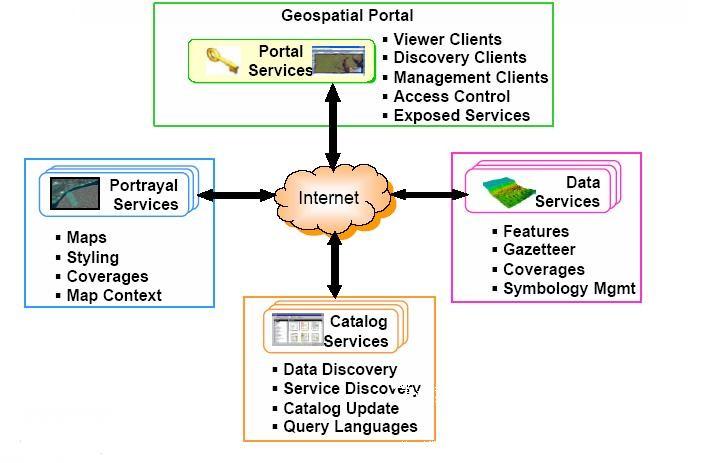
7 7
8 Spatial database Administrative/electoral Boundaries Gram Panchayath Boundary Hobli Boundary Taluk Panchayath Boundary Zilla Panchayath Boundary Village Boundary etc Headquarters Gram Panchayath Headquarters Hobli Headquarters Taluk Panchayath Headquarters Settlements etc 8
9 State Level Data Agro-Climatic Zones Taluk/District Boundary District Head Quarters Division Boundary Division Head Quarters Geology Meteorological Station Parliamentary Constituencies Legislative Assembly Constituencies Rail network Reservoir Rain gauge Station River Drainage Basin Boundary Catchment Boundary Sub catchment Boundary Subdivision Boundary Sub watershed Boundary Tanks National Highway State Highway Major district road Other District Roads Village roads Airport etc., 9
10 Non spatial Database 2001 Census Data (part I and part II) Samanya Mahiti data 21 sectors -357 fields (Infrastructure & Developmental activities-habitation wise) Part of the data has been integrated. District line department data
11
12 BORE WELLSDENSITY & CARRYING CAPACITY OF KOLAR DISTRICT BAGEPALLI BAGEPALLI kilometers CARRYING CAPACITY B.W /Sq.Km GUDIBANDA GUDIBANDA GAURIBIDANUR GAURIBIDANUR CHIKBALLAPUR CHIKBALLAPUR CHINTHAMANI CHINTHAMANI SIDLAGHATTA SIDLAGHATTA SRINIVASAPURA SRINIVASAPURA BORE WELLS 16,000 NO. OF BORE WELLS-1994 NO. OF BORE WELLS-2004 CARRYING CAPACITY No. of wells , ,31,390 KOLAR KOLAR MALUR MALUR Prepared by Dis trict NRDM S centre Zilla Panchayath, Kolar,2006 Source: M GD,2005 BANGARPET BANGARPET MULABAGAL MULABAGAL NO. OF BORE WELL/ Sq.Km. During
13 EXISTING AND PROPOSED HEALTH FACILITIES ( PHC & CHC) IN BELTHANGADY TALUK WITH JURISDICTION OF EXISTING PHCS AND CHCS MALAVANTHIGE KILOMETERS NARAVI Jurisdiction of Existing PHCs & CHCs INDABETTU ALADANGADY NERIYA MUNDAJE ALADANGADY (11) BELTHANGADY (15) DHARMASTALA (2) HATHYADKA (4) INDABETTU (6) KOKKADA (4) MUNDAJE (4) NARAVI (8) NERIYA (5) PADANGADY (9) UJIRE (3) VENOOR (10) VENOOR UJIRE PADANGADI Existing PHCs BELTHANGADY DHARMASTALA Proposed PHCs Villages without PHC within 10 Kms. KANIYURU HATYADKA Existing CHCs KOKKADA ELANTILA NOTE: SHOWS PHC KANIYURU WHICH IS SANCTIONED BUT NOT STARTED. HENCE NO SEPERATE JURISDICTION IS GIVEN FOR THE SAME Karnataka NRDMS MAP PREPARED BY: DK NRDMS MANGALORE 13
14 Development of KSSDI Portal Inventory of databases Functional requirements of website/portal Notification of Expression of Interest (EOI) Pre-bid meeting with Industry/agencies Preparation of Request for proposal (RFP) 1. Technical bid (scope of work) 2. Financial bid (hardware/software/networking/development etc.) Invitation to bidders RFP Evaluation of technical bids Short listing of bidders Evaluation of financial bids Identification of bidder for implementation Technical committee for monitoring project implementation Stakeholders meeting formulate policies/standards 14
15 Stages of Portal development Requirement analysis Real world object catalogue Conceptual Data Model Centralized database Publishing metadata Creation of Geo-portal Customization of software for creation of Geo-portal Security system to handle data, identity & network Testing of the Geo-portal/ database/ services User acceptance testing Final deployment of the complete system Training System maintenance for three years 15
16 User requirements/applications Selective List S. No. Department/ Programme Application Application Query Data Required Department of Education. Opening of New Primary School Show all villages for which a primary Village Boundary Dataset, school doesn t exist within a radius Primary Schools Point of 1.5 Kms (Buffer Analysis). Dataset, Census Data for Attribute Data Health and Family Welfare Villages with Primary Health Show all villages where Primary Village Boundary, Village Dept. Centres Health Care Centres are available Settlements and Medical Facilities (part of Census) Attributes. Minor Irrigation Taluk wise Minor Irrigation Show all the Minor Irrigation Tank Taluk Boundary, Minor Department Tanks Locations based on the Taluk Irrigation Tanks (Point Selected. Data), Attribute Data Department of Education Opening of new school in Show villages without schools and Spatial Data: Village (District Primary Education villages whose population is > 300. Boundary & Village Programme) Settlements Attribute Details: Educational Facilities & Population Department of Education Construction of new rooms for Show schools and whose population Spatial Data: Village schools. is > 600 and rooms < 6. Boundary & Village Settlements Attribute Details: Educational Facilities 16
17 User requirements/applications Selective List Watershed Development Locating Watersheds with more Show the Watersheds with Area > LAC Boundary, Dept. than 1000Ha under a Constituency 1000Ha and under an LAC Watershed (Legislative Assembly constituency) Boundary Fishery Farmer Development Agency(FFDA) Minor Irrigation Dept. Location of M.I tanks having Show all the MI Tanks having fishing activities based on Taluks Fishing Activity under a Taluk. Location of MI Tanks based on Taluk Department of Education / Locating Schools with RDPR implementation of Rainwater harvesting method Panchayath Raj Engineering Dept. Locating Schools with Drinking Water and Toilet Facilities Panchayath Raj Engineering Dept. Locating wasteland greater than 100 Hectares under a district. Taluk Boundary, Tanks Locate the MI Tanks based on Taluk Taluk Boundary, Tanks. Show the Schools that implement Taluk Boundary, Rainwater Harvesting (Search may Village Boundary, be based on Taluk/Village) Educational Facilities. Show the Schools with Drinking Taluk Boundary, water and Toilet Facilities (Search Village Boundary, may be based on Taluk/Village) Village Settlements and Educational Facilities. Locate wasteland areas greater District Boundary, than 100 Hectares under a District. Waste Land 17

18 Understanding processing 18
19 Village with Primary Health Centres (PHC) Name of the application: Villages with Primary Health Centres Name of the department: Health and Family Welfare Dept. Name of the program: NA Brief about the application: Application Query: Data Required: This application will allow the users in locating the Villages with Primary Health Centres. Show all villages where Primary Health Centres are available. Village Boundary, Village Settlements and Medical Facilities for attribute details. Spatial Overlay Conceptual Design of the application: 1..* Village Settlements -VILLAGE _CODE -SETTLEMENT _ID () 1 Village Boundary -VILLAGE -W ithin _CODE -Contains Medical Facilities -VILAG E _CO DE -PH _CNTR Description: Village Boundary: Village boundary Dataset. Village Settlements: All the facilities available at a village level (Point Dataset). Medical Facilities: Primary Health Centres information as part of the census attributes. Spatial Overlay (): Method for the application. Within & contains is the spatial relationship existing Karnataka between Geoportal the datasets. 19
20 Real World Object Catalogue KSSDI Real World Object Catalogue Comprises Hierarchy and Classification of Datasets: Real World Objects: Based on the hierarchy, the datasets are identified as the real world objects. E type, category, scale, definition, source and finally its attributes are designed for the future use. Layer/Dataset Real World Object Properties Layer/Dataset Real World Object Properties Physical Data Model 20

21 KSSDI Data Model 21

22 Karnataka GeoPortal s Login Page The Geo Portal provides the site overview and secure access through login to the geospatial content and features of the SDI.

23 Karnataka GeoPortal s Home Page On Login into the Geo Portal, the user have access to the various modules of the SDI.
24 Karnataka GeoPortal s Map Viewer Geo Portal Map Viewer module by default displays State Division and District Boundaries The Layer Tab on the left pane displays the list of layers that can be made visible at various map scales. User also have the ability to switch ON or OFF layers by using the Eye icon against each layer. The General Map Viewing tools available are: Zoom, Pan, Full view, Previous and next view, Identify, Measure, Refresh and Load context. It also provides the scale bar, X Y coordinates, SRS (Spatial Reference System) and Over View Map display along with Google Map layer display.

25 Karnataka GeoPortal s Map Viewer Add Layer Tab allows user to search for the available services through Key Word Search or Spatial Extent using the Select Tool from the Toolbar. The Resulted services will be displayed and by clicking View on Map, the selected layer gets displayed on the current Map Viewer. Note: The current map displays the Division & District boundary with the State National Highway Layer resulted in the search above.
26 Karnataka GeoPortal s Map Viewer 3 The Query Module provide option to query on attributes, spatial or combination of them to generate desired results. The Application query sub module can be used to create and store commonly used queries that are regularly used for planning and decision making purpose. Note: The current map viewer shows the Query on District Layer, Highlighting the districts with SC Population greater than 30%.
27 Karnataka GeoPortal s Map Viewer The Attribute Query Sub Module provides the ability to select multiple layers with or without spatial join and operators with input values to generate results and view them too on map. Note: The current map viewer shows the Query on District Layer, Highlighting the Districts with TOTAL ST POPULATION >


28 Karnataka GeoPortal s Map Viewer 1. The Export module allows the user to select a specific layer for export to GML and SHAPE file format. Note: The above screen shot shows Export of District layer to GML.
29 Karnataka GeoPortal s Map Viewer 1. The Discover Module allows users to discover map services hosted at remote locations for viewing within the current map viewer as an overlay. Note: The current map viewer shows the discovery of WMS Services from the local server. (Same way can be used to discover services on Remote Servers).
 in the KSSDI Data Repository. 2.")
30 Karnataka GeoPortal s Catalog 1. Product Catalogue allows user to search the Published Web Services (WMS/WFS/WCS) in the KSSDI Data Repository. 2. It presents the Metadata of the selected Layer (NSDI Metadata Standard 2.0). 3. Also allows a user to all the layers to cart.


31 Karnataka GeoPortal s Catalog Harvesting Harvest option allows the user to register published services under the KSSDI service repository. Registered services can be accessed for viewing and querying. Metadata details can also be viewed and updated for those services.

32
33

34 KSSDI Architecture 34

35 35
ESTABLISHMENT OF KARNATAKA GEOPORTAL AND ITS ROLE IN PLANNING
 ESTABLISHMENT OF KARNATAKA GEOPORTAL AND ITS ROLE IN PLANNING By H. Hemanth Kumar Karnataka State Council for Science & Technology (KSCST), Indian Institute of Science, Bangalore, India Abstract Natural
Spatial Data Infrastructure Concepts and Components. Douglas Nebert U.S. Federal Geographic Data Committee Secretariat
 Spatial Data Infrastructure Concepts and Components Douglas Nebert U.S. Federal Geographic Data Committee Secretariat August 2009 What is a Spatial Data Infrastructure (SDI)? The SDI provides a basis for
for Effective Land Administration
 Role of Geospatial Technology in Land Information System(LIS) for Effective Land Administration Dr. Deb Jyoti Pal Sections Role of GIS in Land Records Proposed Work Flow Case Studies Role of GIS Creating
CLICK HERE TO KNOW MORE
 CLICK HERE TO KNOW MORE GeoSpace for Singapore s Whole-of-Government Data Sharing Asia GeoSpatial Forum 17 19 Oct 2011 Lee Kim Haw Singapore Land Authority Introducing Singapore Land Authority Limited
National GIS Platform for Digital India. Dr.(Mrs.) Vandana Sharma Deputy Director General National Informatics Centre
 Vandana Sharma Deputy Director General National Informatics Centre") National GIS Platform for Digital India Dr.(Mrs.) Vandana Sharma Deputy Director General National Informatics Centre sharma.vandana@nic.in NIC DEITY - National e-governance Infrastructure Meghraj Cloud
National GIS Platform for Digital India Dr.(Mrs.) Vandana Sharma Deputy Director General National Informatics Centre sharma.vandana@nic.in NIC DEITY - National e-governance Infrastructure Meghraj Cloud
CLICK HERE TO KNOW MORE
 CLICK HERE TO KNOW MORE Geoinformatics Applications in Land Resources Management G.P. Obi Reddy National Bureau of Soil Survey & Land Use Planning Indian Council of Agricultural Research Amravati Road,
Geospatial SDI Portal for effective Governance of Pune METROPOLIS region
 Geospatial SDI Portal for effective Governance of Pune METROPOLIS region Mr. Praveen Gautam Senior Manager 19 th January 2018 PMRDA Overview Provide a Spatial Framework for the entire region with various
Land Board, NW Services and SDI Tambet Tiits, FRICS
 Land Board, NW Services and SDI Tambet Tiits, FRICS 07.09.2016 200th anniversary of the Struve Geodetic Arc Friedrich Georg Wilhelm Struve and Carl Friedrich Tenner Struve Geodetic Arc The Struve Geodetic
Karnataka GIS. Preview of K-GIS Components, Status, Policies, Opportunities, Challenges and Vision M.JAYACHANDRAN. KGIS - Mission Management
 Karnataka GIS Preview of K-GIS Components, Status, Policies, Opportunities, Challenges and Vision BY M.JAYACHANDRAN KGIS - Mission Management Karnataka State Remote Sensing Applications Center, GoK 18-Jan-2018
Integrated Geodatabase Model for effective planning of District -Hamirpur
 Integrated Geodatabase Model for effective planning of District -Hamirpur Developed by District Administration,Hamirpur in collaboration with Centre for Geoinformatics Research and Training, CSK HPAU,Palampur
Building a National Data Repository
 Building a National Data Repository Mladen Stojic, Vice President - Geospatial 1/30/2013 2012 Intergraph Corporation 1 Information has meaning and gives power only when shared and distributed. Information,
Global Geospatial Information Management Country Report Finland. Submitted by Director General Jarmo Ratia, National Land Survey
 Global Geospatial Information Management Country Report Finland Submitted by Director General Jarmo Ratia, National Land Survey Global Geospatial Information Management Country Report Finland Background
Evaluating Sustainability of the Georesources Observation System
 Evaluating Sustainability of the Georesources Observation System Michael Mente Federal Institute for Geosciences and Natural Resources Germany, Hannover GEOSS-CBC Meeting Athens April 27th 28th, 2009 GEOSS-CBC
Corporate. Information. Railway Infrastructure Administrator. Year indracompany.com
 geospatial and mobility Corporate Geographic Information System of ADIF Railway Infrastructure Administrator. Year 2009-2010 Corporate Geographic Information System of ADIF ADIF. Spanish Administrator
INDONESIA S S UPDATE: GEOSPATIAL INFORMATION FOR SUSTAINABLE DEVELOPMENT RELATED TO INA SDI Dr. Asep Karsidi, M.Sc
 INDONESIA S S UPDATE: GEOSPATIAL INFORMATION FOR SUSTAINABLE DEVELOPMENT RELATED TO INA SDI Dr. Asep Karsidi, M.Sc GEOSPATIAL INFORMATION AGENCY 08 August, 2012 OUTLINE 1. Transformation Bakosurtanal into
Combining Geospatial and Statistical Data for Analysis & Dissemination
 Combining Geospatial and Statistical Data for Analysis & Dissemination (with Special Reference to Qatar Census 2010) Presentation by Mansoor Al Malki, Director of IT Department Qatar Statistics Authority
Upgrade the Datasets in NSDI for Smarter Services with the Cases of China
 Upgrade the Datasets in NSDI for Smarter Services with the Cases of China By Dr. JIANG Jie Dept of GeoInformaiton Service Platform National Geomatics Center of China October 7, 2015 Jeju, Republic of Korea
SDI Development in Georgia. Mari Khardziani Head of International Relations Unit National Agency of Public Registry
 SDI Development in Georgia Mari Khardziani Head of International Relations Unit National Agency of Public Registry Kehl, Germany September 5, 2017 2 National Agency of Public Registry Legal Entity of Public
INSPIRing Geospatial Framework For Local Administrations
 This project is financed by the European Union and the Republic of Turkey Presented at the FIG Congress 2018, May 6-11, 2018 in Istanbul, Turkey National Programme for Turkey 2010 Instrument for Pre-Accession
Ministry of Health and Long-Term Care Geographic Information System (GIS) Strategy An Overview of the Strategy Implementation Plan November 2009
 Strategy An Overview of the Strategy Implementation Plan November 2009") Ministry of Health and Long-Term Care Geographic Information System (GIS) Strategy An Overview of the Strategy Implementation Plan November 2009 John Hill, Health Analytics Branch Health System Information
Ministry of Health and Long-Term Care Geographic Information System (GIS) Strategy An Overview of the Strategy Implementation Plan November 2009 John Hill, Health Analytics Branch Health System Information
Technical Framework Methodology as a core of building up the NSDI NSDI Implementation Specifics in Serbia
 Technical Framework Methodology as a core of building up the NSDI NSDI Implementation Specifics in Serbia Luka Jovičić SDI Consultant@ Gramont Ltd. Aleksandar Dedić RGA NSDI department Dragica Pajić RGA
Module - 3 GIS MAPPING, MIS AND GIS UNDER RAY
 Module - 3 1 GIS MAPPING, MIS AND GIS MIS INTEGRATION UNDER RAY Role of GIS & MIS under RAY Under the scheme, two step implementation strategy has been adopted i.e. preparation of SFCPoAs on whole city
Portals: Standards in Action
 Portals: Standards in Action David Danko ISO TC 211 Metadata Project Leader GIS Standards Consultant-ESRI. Metadata Portals Portal gateway, place of entry Producers Advertise, expose products Share information
Geographic Resources Decision Support System for land use, land cover dynamics analysis
 Proceedings of the FOSS/GRASS Users Conference - Bangkok, Thailand, 12-14 September 2004 Geographic Resources Decision Support System for land use, land cover dynamics analysis T. V. Ramachandra*+, Uttam
Ministry of ICT of I.R.IRAN
 The ECO 8/6 mill km 2 10 Slamic countries ~330 mill people Oil, Gas, Industries,Tourism 2 Issue transformation in last decade Problem solving needs more integrated approach More interaction &complexity
DP Project Development Pvt. Ltd.
 Dear Sir/Madam, Greetings!!! Thanks for contacting DP Project Development for your training requirement. DP Project Development is leading professional training provider in GIS technologies and GIS application
GIS Building Communities beyond National Borders (Building Successful Spatial Data Infrastructures) Nick Land, ESRI Europe
 Nick Land, ESRI Europe") GIS Building Communities beyond National Borders (Building Successful Spatial Data Infrastructures) Nick Land, ESRI Europe UK worst flooding in the last 60 years 350,000 households without drinking water
GIS Building Communities beyond National Borders (Building Successful Spatial Data Infrastructures) Nick Land, ESRI Europe UK worst flooding in the last 60 years 350,000 households without drinking water
ROAD INFORMATION SYSTEM FOR MAINTENANCE MANAGEMENT OF ROAD INFRASTRUCTURE PROJECTS
 ROAD INFORMATION SYSTEM FOR MAINTENANCE MANAGEMENT OF ROAD INFRASTRUCTURE PROJECTS Need for GIS Voluminous/ Manual Data Vs Digital Need for GIS CE - C&B (North) KPWD Secretary Office CE - C&B (South) Dispersed
EXPECTATIONS OF TURKISH ENVIRONMENTAL SECTOR FROM INSPIRE
 EXPECTATIONS OF TURKISH ENVIRONMENTAL SECTOR FROM INSPIRE June, 2010 Ahmet ÇİVİ Tuncay DEMİR INSPIRE in the Eyes of MoEF Handling of Geodata by MoEF Benefits Expected TEIEN First Steps for INSPIRE Final
Pegaso map viewer workshop
 PEGASO / 05 Deliverable Plan 2010-12-23 Pegaso Project People for Ecosystem based Governance in Assessing Sustainable development of Ocean and coast Funded by the European Union under FP7 ENV.2009.2.2.1.4
Roadmap to interoperability of geoinformation
 Roadmap to interoperability of geoinformation and services in Europe Paul Smits, Alessandro Annoni European Commission Joint Research Centre Institute for Environment and Sustainability paul.smits@jrc.it
COUNTY SPATIAL DATA INFRASTRUCTURE PRESENTATION: BY: GEOFREY CHERUIYOT NAIROBI CITY COUNTY
 . COUNTY SPATIAL DATA INFRASTRUCTURE PRESENTATION: BY: GEOFREY CHERUIYOT NAIROBI CITY COUNTY FRAMEWORK FOR AN INTEGRATED SPATIAL DATA INFRASTRUCTURE County GIS GIS : A computer based information system
2007 / 2008 GeoNOVA Secretariat Annual Report
 2007 / 2008 GeoNOVA Secretariat Annual Report Prepared for: Assistant Deputy Minister and Deputy Minister of Service Nova Scotia and Municipal Relations BACKGROUND This report reflects GeoNOVA s ongoing
e-pathai GIS (Electronic Project, Administration, Traffic, Highway Assets and Information management system) in Tamil Nadu Highways
 in Tamil Nadu Highways") e-pathai GIS (Electronic Project, Administration, Traffic, Highway Assets and Information management system) in Tamil Nadu Highways Er.G.Kumar¹, Er.R.Sendel Raj², Er.P.Eshwarmoorthy³, Dr.P.Rajakumar 4
e-pathai GIS (Electronic Project, Administration, Traffic, Highway Assets and Information management system) in Tamil Nadu Highways Er.G.Kumar¹, Er.R.Sendel Raj², Er.P.Eshwarmoorthy³, Dr.P.Rajakumar 4
GEOGRAPHIC INFORMATION SYSTEMS Session 8
 GEOGRAPHIC INFORMATION SYSTEMS Session 8 Introduction Geography underpins all activities associated with a census Census geography is essential to plan and manage fieldwork as well as to report results
THAILAND NSDI DVELOPMENT PROGRAM: ThaiSDI
 THAILAND NSDI DVELOPMENT PROGRAM: ThaiSDI Dr.Chaowalit Silapathong Director of Geo-informatics Office Geo-Informatics and Space Technology Development Agency (Public Organization): GISTDA chaow@gistda.or.th
Discovery and Access of Geospatial Resources using the Geoportal Extension. Marten Hogeweg Geoportal Extension Product Manager
 Discovery and Access of Geospatial Resources using the Geoportal Extension Marten Hogeweg Geoportal Extension Product Manager DISCOVERY AND ACCESS USING THE GEOPORTAL EXTENSION Geospatial Data Is Very
Key Points Sharing fosters participation and collaboration Metadata has a big role in sharing Sharing is not always easy
 Sharing Resources Geoff Mortson esri, Inc. SDI Solutions Team Key Points Sharing fosters participation and collaboration Metadata has a big role in sharing Sharing is not always easy Data Sharing is Good
Qatar Statistical Geospatial Integration
 Qatar Statistical Geospatial Integration A Presentation by the Ministry of Development Planning & Statistics (MDPS), State of Qatar http://www.mdps.gov.qa (Fourth UN-GGIM Arab States Committee Meeting,
Regione Umbria. ESRI EMEA User Conference 2010 Rome, October 27th 2010
 Direzione Ambiente, Territorio e Infrastrutture Servizio Informatico/Informativo: geografico, ambientale e territoriale ESRI EMEA User Conference 2010 Rome, October 27th 2010 Arch. Ambra Ciarapica, Dott.
Demonstration of a local SDI solution with several stakeholders in pilot areas in line with EU best practices
 EU Twinning project for the Agency of Land Relations and Cadaster (ALRC)- Organization, Streamlining and Computerization Process in Mapping in the Republic of Moldova. Demonstration of a local SDI solution
Status of implementation of the INSPIRE Directive 2016 Country Fiches. COUNTRY FICHE Ireland
 Status of implementation of the INSPIRE Directive 2016 Country Fiches COUNTRY FICHE Ireland Introduction... 1 1. State of Play... 2 1.1 Coordination... 2 1.2 Functioning and coordination of the infrastructure...
Evaluating Physical, Chemical, and Biological Impacts from the Savannah Harbor Expansion Project Cooperative Agreement Number W912HZ
 Evaluating Physical, Chemical, and Biological Impacts from the Savannah Harbor Expansion Project Cooperative Agreement Number W912HZ-13-2-0013 Annual Report FY 2018 Submitted by Sergio Bernardes and Marguerite
Water Data Sharing an Update
 Water Data Sharing an Update By David R. Maidment Leader, CUAHSI Hydrologic Information System Project and Director, Center for Research in Water Resources, University of Texas at Austin Prepared for Subcommittee
Development of spatial health data infrastructure (SHDI) at Vadu Health and Demographic Surveillance Site (HDSS, Vadu) using open source technologies.
 at Vadu Health and Demographic Surveillance Site (HDSS, Vadu) using open source technologies.") Development of spatial health data infrastructure (SHDI) at Vadu Health and Demographic Surveillance Site (HDSS, Vadu) using open source technologies. Dr. Anand Akmanchi, Lecturer, Geoinformatics Mr. Vivek
Development of spatial health data infrastructure (SHDI) at Vadu Health and Demographic Surveillance Site (HDSS, Vadu) using open source technologies. Dr. Anand Akmanchi, Lecturer, Geoinformatics Mr. Vivek
An Internet-Based Integrated Resource Management System (IRMS)
") An Internet-Based Integrated Resource Management System (IRMS) Third Quarter Report, Year II 4/1/2000 6/30/2000 Prepared for Missouri Department of Natural Resources Missouri Department of Conservation
An Internet-Based Integrated Resource Management System (IRMS) Third Quarter Report, Year II 4/1/2000 6/30/2000 Prepared for Missouri Department of Natural Resources Missouri Department of Conservation
Regional EGM on Community of Practice of Georeferenced Information System. for Disaster Risk Management (Geo-DRM) April 2014, Bangkok, Thailand
 April 2014, Bangkok, Thailand") Regional EGM on Community of Practice of Georeferenced Information System for Disaster Risk Management (Geo-DRM) 23-25 April 2014, Bangkok, Thailand Presented By Mukesh Kumar Keshari Ministry of Home Affairs
Regional EGM on Community of Practice of Georeferenced Information System for Disaster Risk Management (Geo-DRM) 23-25 April 2014, Bangkok, Thailand Presented By Mukesh Kumar Keshari Ministry of Home Affairs
INSPIRE Basics. Vlado Cetl European Commission Joint Research Centre. https://ec.europa.eu/jrc/
 INSPIRE Basics Vlado Cetl European Commission Joint Research Centre https://ec.europa.eu/jrc/ Serving society Stimulating innovation Supporting legislation Outline SDI? Why European SDI? INSPIRE Policy
VILLAGE INFORMATION SYSTEM (V.I.S) FOR WATERSHED MANAGEMENT IN THE NORTH AHMADNAGAR DISTRICT, MAHARASHTRA
 FOR WATERSHED MANAGEMENT IN THE NORTH AHMADNAGAR DISTRICT, MAHARASHTRA") VILLAGE INFORMATION SYSTEM (V.I.S) FOR WATERSHED MANAGEMENT IN THE NORTH AHMADNAGAR DISTRICT, MAHARASHTRA Abstract: The drought prone zone in the Western Maharashtra is not in position to achieve the agricultural
VILLAGE INFORMATION SYSTEM (V.I.S) FOR WATERSHED MANAGEMENT IN THE NORTH AHMADNAGAR DISTRICT, MAHARASHTRA Abstract: The drought prone zone in the Western Maharashtra is not in position to achieve the agricultural
Realizing benefits of Spatial Data Infrastructure A user s perspective from Environment Agency - Abu Dhabi
 Realizing benefits of Spatial Data Infrastructure A user s perspective from Environment Agency - Abu Dhabi Anil Kumar Director, Environment Information Management 26 April 2012 Geospatial World Forum,
REPORT ON DIVISIONAL LEVEL TRAINING PROGRAM ON. APPLICATION OF REMOTE SENSING AND GIS FOR GOVERNANCE (Held during August and September, 2013)
") REPORT ON DIVISIONAL LEVEL TRAINING PROGRAM ON APPLICATION OF REMOTE SENSING AND GIS FOR GOVERNANCE (Held during August and September, 2013) Co-ordinator: H Hemanth Kumar Fellow & Principal Investigator
REPORT ON DIVISIONAL LEVEL TRAINING PROGRAM ON APPLICATION OF REMOTE SENSING AND GIS FOR GOVERNANCE (Held during August and September, 2013) Co-ordinator: H Hemanth Kumar Fellow & Principal Investigator
Spatially Enabled Society
 International Seminar on Land Administration Trends and Issues in Asia and the Pacific Region Spatially Enabled Society Abbas Rajabifard Vice Chair PCGIAP-WG3 Vice-President (President Elect), GSDI Association
ADDRESSING THE DATA AND INFORMATION NEEDS FOR GOOD GOVERNANCE, SHARING EXPERIENCES FROM COTE D IVOIRE. 20 April 2016 to 22 April 2016 ADDIS ABABA
 20 April 2016 to 22 April 2016 ADDIS ABABA ADDRESSING THE DATA AND INFORMATION NEEDS FOR GOOD GOVERNANCE, SHARING EXPERIENCES FROM COTE D IVOIRE Dr. Edouard FONH-GBEI Director General of CNTIG, General
Using MAGIC to Access Spatial Imagery: Putting ER Mapper Image Web Server, ArcIMS and MrSID to work in your Library
 Using MAGIC to Access Spatial Imagery: Putting ER Mapper Image Web Server, ArcIMS and MrSID to work in your Library Patrick McGlamery Shirley Quintero University of Connecticut Libraries Building the Connecticut
GMES Service for Geospatial Reference Data Access (RDA) Covering Areas Outside Europe
 Covering Areas Outside Europe") INSPIRE Conference 2011 Edinburgh 27 June - 1 July GMES Service for Geospatial Reference Data Access (RDA) Covering Areas Outside Europe Andrea Ajmar, Simone Balbo, Piero Boccardo, Simone Dalmasso, Anna
INSPIRE Conference 2011 Edinburgh 27 June - 1 July GMES Service for Geospatial Reference Data Access (RDA) Covering Areas Outside Europe Andrea Ajmar, Simone Balbo, Piero Boccardo, Simone Dalmasso, Anna
Estonian approach to implementation of INSPIRE directive. Sulev Õitspuu Head of Bureau of Geoinfosystems Estonian Land Board
 Estonian approach to implementation of INSPIRE directive Sulev Õitspuu Head of Bureau of Geoinfosystems Estonian Land Board 13.06.2016 Contents - INSPIRE coordination in Estonia - INSPIRE implementation
Global Challenges And Indian Initiatives *
 HIGH LEVEL FORUM ON GLOBAL GEOSPATIAL MANAGEMENT INFORMATION WORKING PAPER No. 15 First Forum Seoul, Republic of Korea, 24-26 October 2011 Global Challenges And Indian Initiatives * * Submitted by: Mr.
Data Aggregation with InfraWorks and ArcGIS for Visualization, Analysis, and Planning
 Data Aggregation with InfraWorks and ArcGIS for Visualization, Analysis, and Planning Stephen Brockwell President, Brockwell IT Consulting, Inc. Join the conversation #AU2017 KEYWORD Class Summary Silos
SWEDISH SDI DEVELOPMENT & IMPLEMENTATION OF INSPIRE
 SWEDISH SDI DEVELOPMENT & IMPLEMENTATION OF INSPIRE Christina Wasström, Lantmäteriet, 801 82 Gävle, Sweden, christina.wasstrom@lm.se ABSTRACT The Swedish Government and Parliament has given Lantmäteriet
Spatial data interoperability and INSPIRE compliance the platform approach BAGIS
 Spatial data interoperability and INSPIRE compliance the platform approach BAGIS BAGIS Voluntary, independent, public, non-profit organization; Organization with main mission to promote the growth of the
Challenges in Geospatial Policy Formulation and Programme Management
 Challenges in Geospatial Policy Formulation and Programme Management Luiz Paulo Souto Fortes, PhD An Exchange with the Geospatial Industry for UN-GGIM Seoul, October 23, 2011 BRAZIL Land area 8,514,876.599
Presented to Sub-regional workshop on integration of administrative data, big data and geospatial information for the compilation of SDG indicators
 Presented to Sub-regional workshop on integration of administrative data, big data and geospatial information for the compilation of SDG indicators 23-25 April,2018 Addis Ababa, Ethiopia By: Deogratius
Working with Census Operations Case Study from KSA
 Working with Census Operations Case Study from KSA International Workshop on Integrating Geospatial and Statistical Information Beijing 9 12 June 2014 Abdullah M.Alhamlan Kingdom of Saudi Arabia Central
The Swedish National Geodata Strategy and the Geodata Project
 The Swedish National Geodata Strategy and the Geodata Project Ewa Rannestig, Head of NSDI Co-ordination Unit, Lantmäteriet, ewa.rannstig@lm.se Ulf Sandgren, Project Manager Geodata Project, Lantmäteriet,
A FOSS approach to Integrated Water Resource Management: the case study of Red-Thai Binh rivers system in Vietnam
 A FOSS approach to Integrated Water Resource Management: the case study of Red-Thai Binh rivers system in Vietnam Carolina Arias Munoz1, Maria Antonia Brovelli1, Simone Corti1, Marco Micotti2, Rodolfo
CENSUS MAPPING WITH GIS IN NAMIBIA. BY Mrs. Ottilie Mwazi Central Bureau of Statistics Tel: October 2007
 CENSUS MAPPING WITH GIS IN NAMIBIA BY Mrs. Ottilie Mwazi Central Bureau of Statistics E-mail: omwazi@npc.gov.na Tel: + 264 61 283 4060 October 2007 Content of Presentation HISTORICAL BACKGROUND OF CENSUS
CHAPTER 22 GEOGRAPHIC INFORMATION SYSTEMS
 CHAPTER 22 GEOGRAPHIC INFORMATION SYSTEMS PURPOSE: This chapter establishes the administration and use of to improve the quality and accessibility of Department s spatial information and support graphical
Bentley Map Advancing GIS for the World s Infrastructure
 Bentley Map Advancing GIS for the World s Infrastructure Presentation Overview Why would you need Bentley Map? What is Bentley Map? Where is Bentley Map Used? Why would you need Bentley Map? Because your
FAO GAEZ Data Portal
 FAO GAEZ Data Portal www.fao.org/nr/gaez Renato Cumani Environment Officer Land and Water Division Natural Resources Management and Environment Department Food and Agriculture Organization of the UN October
Technical and Administrative Challenges in Collecting Geoinformation to Function as a Flexible Regional Geoinformation Base.
 Technical and Administrative Challenges in Collecting Geoinformation to Function as a Flexible Regional Geoinformation Base. S.D.P.J. Dampegama Additional Surveyor General Survey Department of Sri Lanka
Building an Enterprise GIS for Chicago s Water Reclamation District
 Building an Enterprise GIS for Chicago s Water Reclamation District Presenters Presented at the 2010 ESRI User Conference Authored and Presented By Sanjay Patel, PE, CEM, CMRP Metropolitan Water Reclamation
Section 2. Indiana Geographic Information Council: Strategic Plan
 Section 2. Indiana Geographic Information Council: Strategic Plan Introduction A geographic information system (GIS) is an automated tool that allows the collection, modification, storage, analysis, and
Proposal for a DIRECTIVE OF THE EUROPEAN PARLIAMENT AND OF THE COUNCIL. establishing an infrastructure for spatial information in the Community
 Proposal for a DIRECTIVE OF THE EUROPEAN PARLIAMENT AND OF THE COUNCIL establishing an infrastructure for spatial information in the Community INSPIRE http://inspire.jrc.it/ Alessandro Annoni 1 EU Commission
GIS Geographical Information Systems. GIS Management
 GIS Geographical Information Systems GIS Management Difficulties on establishing a GIS Funding GIS Determining Project Standards Data Gathering Map Development Recruiting GIS Professionals Educating Staff
Technical Specifications. Form of the standard
 Used by popular acceptance Voluntary Implementation Mandatory Legally enforced Technical Specifications Conventions Guidelines Form of the standard Restrictive Information System Structures Contents Values
THE SPATIAL DATA WAREHOUSE OF SEOUL
 THE SPATIAL DATA WAREHOUSE OF SEOUL Jae-Ho Han The Seoul Metropolitan Government Seoul City Hall, Taepyeongno 1(il)-ga, Jung-gu, Seoul 100-744, Korea djhjha@hanmail.net Impyeong Lee Dept. of Geoinformatics,
European Location Framework data in the ArcGIS platform
 European Location Framework data in the ArcGIS platform Presentation to: Author: Date: INSPIRE Conference 2016 Clemens Portele 26 September 2016 Why ELF? Global (e.g. UN GGIM) Regional Europe (INSPIRE
GIS Monroe Geographic Information System March 14, 2018
 GIS Monroe Geographic Information System March 14, 2018 Goals Maintain Enterprise/County-wide geo-database Increase spatial accuracy of data Build and acquire more data layers Increase use of GIS; as another
The state-of-the-art of the Finnish SDI. Arctic SDI WG Meeting
 The state-of-the-art of the Finnish SDI Arctic SDI WG Meeting Moscow 8.9.2011 Esa Tiainen Development Centre 1 NATIONAL LAND SURVEY DOWN TO EARTH Contents Legal framework Coordination structure Network
Presented by: Bryan Bloch GIS Specialist DNREC Division of Watershed Stewardship
 Presented by: Bryan Bloch GIS Specialist DNREC Division of Watershed Stewardship Bryan Hall, AICP Sussex County Circuit Rider Planner, Office of State Planning Coordination, OMB November 19, 2012 UD Sustainable
CAPE FARM MAPPER - an integrated spatial portal
 CAPE FARM MAPPER - an integrated spatial portal Skukuza Dr Mike Wallace June 2017 Overview of GIS applications in WCDoA Spatial information and technology has become indispensable across a wide range of
Lesson Plan 3 Google Earth Tutorial on Land Use for Middle and High School
 An Introduction to Land Use and Land Cover This lesson plan builds on the lesson plan on Understanding Land Use and Land Cover Using Google Earth. Please refer to it in terms of definitions on land use
GIS. in the City of Lewiston Maine
 GIS in the City of Lewiston Maine The purpose of this slideshow is to provide an overview of the city GIS and how it is used, maintained and accessed in-house as well as by the public. Please simply hit
Ready for INSPIRE.... connecting worlds. European SDI Service Center
 Ready for INSPIRE Consultancy SOFTWARE T r a i n i n g Solutions... connecting worlds European SDI Service Center Increasing Added Value with INSPIRE and SDI Components INSPIRE In 2007, the European Commission
Overview. Project Background Project Approach: Content and Application Development Application Demonstration Future Developments
 Overview Project Background Project Approach: Content and Application Development Application Demonstration Future Developments Southeast Pressures: Continued Population Growth Transportation Corridors
Implementing INSPIRE in Sweden
 Implementing INSPIRE in Sweden Christina Wasström NSDI-unit, Lantmäteriet Christina.wasstrom@lm.se Standards Cooperation Metadata Competence Infrastructure for Geodata Legal Framework Portal Services Geodata
Spatial Data Availability Energizes Florida s Citizens
 NASCIO 2016 Recognition Awards Nomination Spatial Data Availability Energizes Florida s Citizens State of Florida Agency for State Technology & Department of Environmental Protection Category: ICT Innovations
UTAH S STATEWIDE GEOGRAPHIC INFORMATION DATABASE
 UTAH S STATEWIDE GEOGRAPHIC INFORMATION DATABASE Data Information and Knowledge Management NASCIO Awards 2009 STATE GEOGRAPHIC INFORMATION DATABASE B. EXECUTIVE SUMMARY Utah has developed one of the most
KENYA NATIONAL BUREAU OF STATISTICS Workshop on
 KENYA NATIONAL BUREAU OF STATISTICS Workshop on Capacity Building in Environment Statistics: the Framework for the Development of Environment Statistics (FDES 2013) Coordination with Sector Ministries
Canadian Board of Examiners for Professional Surveyors Core Syllabus Item C 5: GEOSPATIAL INFORMATION SYSTEMS
 Study Guide: Canadian Board of Examiners for Professional Surveyors Core Syllabus Item C 5: GEOSPATIAL INFORMATION SYSTEMS This guide presents some study questions with specific referral to the essential
Harmonizing spatial databases and services at local and regional level
 Harmonizing spatial databases and services at local and regional level A. Ionita 1, M. Caian 2, V. Vassilev 3, V. Craciunescu 2, I. Nedelcu 4 1 Research Institute for Artificial Intelligence, Bucuresti,
Egypt Public DSS. the right of access to information. Mohamed Ramadan, Ph.D. [R&D Advisor to the president of CAPMAS]
![Egypt Public DSS. the right of access to information. Mohamed Ramadan, Ph.D. [R&D Advisor to the president of CAPMAS]](/thumbs/89/98483713.jpg "Egypt Public DSS. the right of access to information. Mohamed Ramadan, Ph.D. [R&D Advisor to the president of CAPMAS]") Egypt Public DSS ì the right of access to information Central Agency for Public Mobilization and Statistics Arab Republic of Egypt Mohamed Ramadan, Ph.D. [R&D Advisor to the president of CAPMAS] Egypt
Egypt Public DSS ì the right of access to information Central Agency for Public Mobilization and Statistics Arab Republic of Egypt Mohamed Ramadan, Ph.D. [R&D Advisor to the president of CAPMAS] Egypt
IV. RESULTS AND DISCUSSION
 Crowd sourcing (Authoritative) of Geographic Information on Public Assets and Amenities H. Hemanth Kumar, Dr. M. Prithviraj, M. J Rathan Raj, Umesh Ghatage and Mohan Kumar. S Karnataka State Council for
Increasing GI awareness in local authorities in Poland experiences from the INSPIRE Academy training programme
 Increasing GI awareness in local authorities in Poland experiences from the INSPIRE Academy training programme http://www.akademiainspire.pl Maria Andrzejewska, Monika Rusztecka UNEP/GRID-Warsaw Centre,
GIS-T 2010 Building a Successful Geospatial Data Sharing Framework: A Ohio DOT Success Story
 GIS-T 2010 Building a Successful Geospatial Data Sharing Framework: A Ohio DOT Success Story ODOT District 2 GIS John Puente District 1 GIS Coordinator\ Planning Administrator 2 Interoperability 3 District
NSDI as a tool for Secure land tenure
 NSDI as a tool for Secure land tenure General Overview To look at the progress in SDI development and its application in policy formulation and impact on land tenure. INTEGRATION OF INFORMATION POLICIES
Georeferencing and Satellite Image Support: Lessons learned, Challenges and Opportunities
 Georeferencing and Satellite Image Support: Lessons learned, Challenges and Opportunities Shirish Ravan shirish.ravan@unoosa.org UN-SPIDER United Nations Office for Outer Space Affairs (UNOOSA) UN-SPIDER
Utah UIC Geospatial Integration EIEN Project
 Utah UIC Geospatial Integration EIEN Project ESRI UC, June 2007 Bert Granberg Utah Automated Geographic Reference Center Utah Automated Geographic Reference Center (AGRC) AGRC Responsibilities Facilitate
Fish Pond. Old Secretariate. Shaheed Smarak
 Fish Pond Old Secretariate Shaheed Smarak HOW SATELLITE SCANS EARTH. Rajbhawan area viewed by IKONOS 1 meter sensor Very high resolution (40 cm) Orbi-Image data Higher the resolution better the geometric
Creation of an Internet Based Indiana Water Quality Atlas (IWQA)
") Department of Environmental Management Creation of an Internet Based Water Quality Atlas (IWQA) May 4, 2005 IUPUI 1200 Waterway Blvd., Suite 100 polis, 46202-5140 Water Quality Atlas John Buechler, Neil
Department of Environmental Management Creation of an Internet Based Water Quality Atlas (IWQA) May 4, 2005 IUPUI 1200 Waterway Blvd., Suite 100 polis, 46202-5140 Water Quality Atlas John Buechler, Neil