EuroSDR Historical data Seminar specific projects. 17. Oktober H. Gollin. armasuisse. Bundesamt für Landestopografie swisstopo
|
|
|
- Shawn Little
- 6 years ago
- Views:
Transcription


1 armasuisse EuroSDR Historical data Seminar specific projects 17. Oktober 2014 H. Gollin
2 Topics «Journey through time» «LUBIS» «Ellipse» Archiving of geodata 2
3 Historical maps Key data foundation in 1838 as «Bureau topographique fédéral» by general Guillaume-Henri Dufour 3 national map series (Topographical Map of Switzerland 1: , Topographical Atlas 1:25.000/1:50.000, National Maps in different scales). ca 29,000 printed maps ca 23,000 manuscript maps (hand-drawn originals), ca 3,500 copper plates and 450 lithograph plates ca 80 additions every year 3

4 Overview of Swiss national map series National map NM25/50/100/ Year Siegfried map TA25/50 Year Dufour map TK100 Year First Edition Revision 4
5 Journey through time with the Swiss National Map series Idea: obvious, when all maps are already existing Federal Act on Geoinformation (Geoinformation Act): view services for all official geodata under federal legislation Cultural heritage of national significance: Topographical landscape memory of Switzerland Publish the treasure in the form of a web service 5
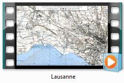
6 Journey through time Realisation all maps had to be scanned with high resolution (508 dpi) project HIKS (Historische Karten scannen) from 2003 onwards. All data sets were geo-referenced (spatial reference information was allocated to the map files) the map bibliographical metadata was captured within Alexandria (library network of the Swiss Federal Administration) metadata can be requested at any point position of the cursor. 6
7 Journey through time Realisation «Journey through time» with the national map series 1: : : All the geo-referenced map files and the links to their bibliographical metadata were first integrated into the RAHDIS data base (Raster- und Höhendaten- Informationssystem) 7
 Print")
8 Journey through time Functionalities Play Compare two periods General Functionality Link / share Advanced functions (draw / measure) Print Help 9

9 Journey through time Functionalities 10

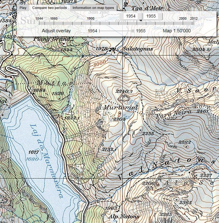
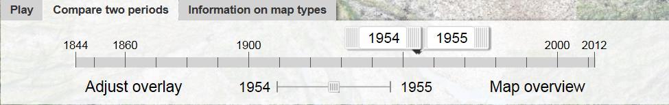
10 Journey through time Functionalities 11


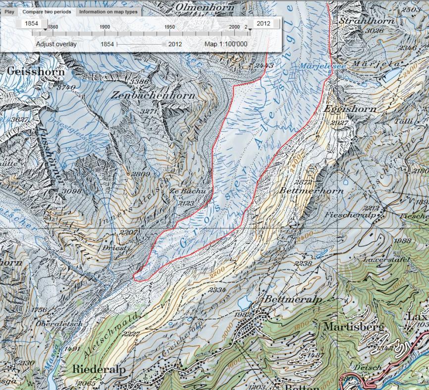
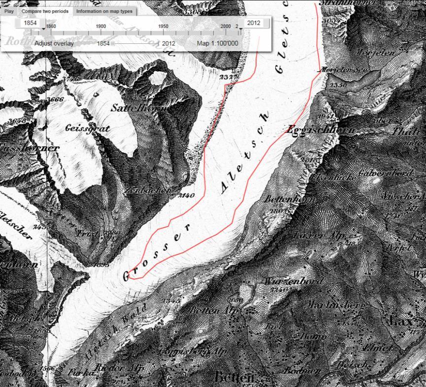
11 Journey through time Functionalities 12


12 Journey through time Functionalities 13
13 Journey through time Experiences th anniversary of swisstopo Within the first two days, over visits were registered, and 70 million map tiles were downloaded, which corresponds to an average of more than 400 tiles per second and a transferred data volume of more than 2.5 TB Costs: marginal compared to acquisition and production much more expensive to only preserve data than to make them available in a state-of-the-art way Use Cases??? 14

14 Journey through time Outlook data Yearly update of map data Small scales 1: , 1: , 1:1 Mio. application Additional techniques to compare periods Migration/integration to the map viewer of the Swiss Federal Geoportal (map.geo.admin.ch) 15
15 Historical aerial & terrestrial images Key data The collection comprises a total of about half a million images Terrestrial images since 1915 Aerial photos since 1926 Orthophotos since 1998 Digital image strips since
16 Historical aerial & terrestrial images The digitised images are accessible in the information system for aerial photographs LUBIS (Luftbild- Informationssystem) LUBIS is continuously filled with digitised historical images and new digital image stripes Since April 2014 the (digital) images are accessible in the LUBIS Dataviewer The LUBIS Dataviewer is an application, based on the federal geoportal Images are displayed with a footprint and meta-information LUBIS Dataviewer 17
17 LUBIS Dataviewer Outlook swisstopo plans to digitise and catalogue the entire inventory of images and make them generally accessible till 2020 ( are done) Search will be possible over a period of time, not only a point in time Other forms of usage: Storymaps 19


18 Project Ellipse Archiving of geodata Preliminary Study Concept Realisation Deutsch / Français / English Deutsch / Français / English 20

19 Archiving of geodata legal bases 21
20 Archiving of geodata Objectives To define the most important aspects of archiving and the framework for securing the long-term availability of geodata, and to identify the related issues and problems Based on the findings obtained from the preliminary study, to formulate a proposal for the next steps to be taken in order to secure the implementation of the geoinformation legislation relating to the archiving of geodata 22
21 Archiving of geodata Objectives The solution should not be specific to swisstopo, but should be developed for the entire federal administration A well-founded integral solution needs to be found for archiving and securing the long-term availability of geodata The solution must permit archived digital geodata to be (subsequently) re-integrated into a GIS one of the fundamental requirements to be placed on the archiving of geodata is that it must be possible to restore and analyse geoinformation at a later date 23


22 Interaction of long-term availability and archiving Gewährleistung der Verfügbarkeit Securing long-term availability Gemeinsame Aufbewahrungsplanung Common preservation planning Nutzer Consumer Forschung Research Nachhaltige Verfügbarkeit Long-term availability Öffentliche Verwaltung Public Administration Erhebung, Nachführung Production, Updating Firmen Enterprises Archivierung Archiving Private Individual user 24
23 Archiving Challenges Key Questions 1. Which geospatial data should be archived and why? 2. How to archive geospatial data? 3. Archiving formats for geospatial data 4. Archiving scenarios, i.e. archiving of geospatial reference data and thematic geospatial data 5. References and Links between archived geospatial data (packages) 6. Future use of archived data, i.e. re-import of archived geospatial data in GIS in 20/50 years 25
24 Ellipse Realisation
25 Ellipse Conservation and archiving planning With all federal offices (producers of geodata) Coordination of the appraisal Official geodata under federal administration and further geodata 27
26 Outlook further future plans Documentation of methods of the photogrammetry Protection of cultural property 28


27 Thank you for your attention! 29
Modular Web Framework for the BRANDENBURGVIEWER
 Modular Web Framework for the BRANDENBURGVIEWER Geoinformation System (GIS) 2 GIS = geo + information + system + + Survey of data Organization of data Processing and Analysis Presentation geodata infrastructure
Data Origin. Ron van Lammeren CGI-GIRS 0910
 Data Origin Ron van Lammeren CGI-GIRS 0910 How to obtain geodata? Geo data initiative Executive Order 12906, "Coordinating Geographic Data Acquisition and Access: The National Spatial Data Infrastructure,"
Access to geological data and 3D-models a new public service?
 Copyright Cost Sub-Urban Access to geological data and 3D-models a new public service? Olivier Lateltin, swiss geological survey swisstopo 1 Switzerland s wild-west underground 2 Underground: a fragmented
Data Origin. How to obtain geodata? Ron van Lammeren CGI-GIRS 0910
 Data Origin How to obtain geodata? Ron van Lammeren CGI-GIRS 0910 Spatial Data interest Improvement of policy making. ± 90% of all information used by government has spatial characteristics SPATIAL INFORMATION
Digital Terrain Model Grid Width 200 m DGM200
 Digital Terrain Model Grid Width 200 m Status of documentation: 23.02.2015 Bundesamt für Kartographie und Geodäsie Seite 1 Contents DGM1000 page 1 Overview of dataset 3 2 Description of the dataset contents
The ecadastre System. Francis KAELL ecadastre project manager
 The ecadastre System Francis KAELL ecadastre project manager ecadastre what s that? A mapping tool to view, combine and analyze geodata in a browser A product catalogue which describes all the available
Utilization and Provision of Geographical Name Information on the Basic Map of Japan*
 UNITED NATIONS WORKING PAPER GROUP OF EXPERTS NO. 1/9 ON GEOGRAPHICAL NAMES Twenty-eight session 28 April 2 May 2014 Item 9 of the Provisional Agenda Activities relating to the Working Group on Toponymic
33 par&cipants 16 countries 5 sessions 16 presenta&ons
 33 par&cipants 16 countries 5 sessions 16 presenta&ons Collection development, facts, figures and trends DUTCH EXPERIENCES rich tradition of institutional map collecting, dating back already to the 16th
Kentucky Collaborates in GeoMAPP Project: The Advantages and Challenges of Archiving in a State with a Centralized GIS
 Kentucky Collaborates in GeoMAPP Project: The Advantages and Challenges of Archiving in a State with a Centralized GIS Geospatial Multistate Archive and Preservation Partnership By Glen McAninch Best Practices
1. Which agency in your state is PRIMARILY responsible for archiving geospatial data and managing archived geo records? (choose one) nmlkj.
 nmlkj.") Survey Intro Kentucky, North Carolina, and Utah are partnering with the Library of Congress as part of the National Digital Information Infrastructure and Preservation Program (NDIIPP) to examine the current
Survey Intro Kentucky, North Carolina, and Utah are partnering with the Library of Congress as part of the National Digital Information Infrastructure and Preservation Program (NDIIPP) to examine the current
Grant Agreement No. EIE/07/595/SI BEn
 Biomass energy register for sustainable site development for European regions Grant Agreement No. EIE/07/595/SI2.499697 BEn Biomass energy register for sustainable site development for European regions
TERMS OF REFERENCE FOR PROVIDING THE CONSULTANCY SERVICES OF
 1 Cartographic Database and TM100 Product Specifications TERMS OF REFERENCE FOR PROVIDING THE CONSULTANCY SERVICES OF Production and establishment of cartographic database for scale 1:100,000 and production
 Boone County GIS has the right to inquire about and investigate the use of any requested products and deny access to anyone based on concerns relating to privacy, security, public health, public safety,
U.S. Army Topographic Engineering Center (TEC) Alexandria, VA. Army Geo-Referenced PDF (GeoPDF) Project
 Alexandria, VA. Army Geo-Referenced PDF (GeoPDF) Project") U.S. Army Topographic Engineering Center (TEC) Alexandria, VA Army Geo-Referenced PDF (GeoPDF) Project June 2006 Ray Caputo Geospatial Information and Imagery Requirements Branch Operations Division The
U.S. Army Topographic Engineering Center (TEC) Alexandria, VA Army Geo-Referenced PDF (GeoPDF) Project June 2006 Ray Caputo Geospatial Information and Imagery Requirements Branch Operations Division The
Conceptual Aspects of 3D Map Integration in Interactive School Atlases
 Conceptual Aspects of 3D Map Integration in Interactive School Atlases Christian Haeberling Hans Rudolf Baer Institute of Cartography ETH Zurich 8093 Zurich, Switzerland E-Mail: haeberling@karto.baug.ethz.ch
INSPIRE Shared Service
 INSPIRE Shared Service Creation and operation out of the box Petra Fritz (HZD), Michael Voigtländer (Esri Deutschland GmbH) INSPIRE Shared Service Agenda HZD backbone for a geodata infrastructure Implementing
McHenry County Property Search Sources of Information
 Disclaimer: The information in this system may contain inaccuracies or typographical errors. The information in this system is a digital representation of information derived from original documents; as
GEOMATICS. Shaping our world. A company of
 GEOMATICS Shaping our world A company of OUR EXPERTISE Geomatics Geomatics plays a mayor role in hydropower, land and water resources, urban development, transport & mobility, renewable energy, and infrastructure
Stay of play in the Serbian geo-sector
 Stay of play in the Serbian geo-sector Republic Geodetic Authority, Serbia IGN France International, France INSPIRE Conference Florence, 27 th June 2013 Outline NSDI status Institutional framework Technical
1 ST High Level Forum on United Nations Global Geoespatial Information Management GEOGRAPHIC REFERENCING OF ECONOMIC UNITS. México
 1 ST High Level Forum on United Nations Global Geoespatial Information Management Thematic Seminar 27 October, Korea 2011. GEOGRAPHIC REFERENCING OF ECONOMIC UNITS México CONTENTS Introduction Census Cartography
EuroSDR (European Spatial Data Research)
") EuroSDR (European Spatial Data Research) ROLLING RESEARCH PLAN 2015-2018 EuroSDR Secretariat Public Governance Institute KU Leuven Parkstraat 45 bus 3609 3000 Leuven Belgium Tel.: +32 16 32 31 80 Fax:
EuroSDR (European Spatial Data Research) ROLLING RESEARCH PLAN 2015-2018 EuroSDR Secretariat Public Governance Institute KU Leuven Parkstraat 45 bus 3609 3000 Leuven Belgium Tel.: +32 16 32 31 80 Fax:
Translating urban history, research and sources, into interactive digital libraries
 Translating urban history, research and sources, into interactive digital libraries Fulvio Rinaudo 1, Rosa Tamborrino 1 1 Politecnico di Torino Dept. Of Architecture & Design Abstract Many results of historical
Comparative analysis of historical maps of the Canton of Zurich - Switzerland in an interactive online platform
 Comparative analysis of historical maps of the Canton of Zurich - Switzerland in an interactive online platform Angeliki Tsorlini, Ionut Iosifescu, Lorenz Hurni ETH Zurich, Institute of Cartography and
Geospatial Preservation: State of the Landscape. A Quick Overview. Steve Morris NCSU Libraries
 Geospatial Preservation: State of the Landscape A Quick Overview Steve Morris NCSU Libraries SAA 2011 August 26, 2011 14 Brief Overview of the Problem 15 Variety of Geospatial Data Types Variety of producers
IRDAT Fvg, evolving a regional Spatial Data Infrastructure according to INSPIRE
 IRDAT Fvg, evolving a regional Spatial Data Infrastructure according to INSPIRE Tutti i diritti riservati. Proprietà INSIEL SpA. A. Benvenuti, A. Chiarandini Insiel (Italy) M. Lunardis - Friuli Venezia
Evolution and development of National Spatial Data Infrastructure in Republic of Moldova
 Agency for Land Relations and Cadastre of the Republic of Moldova Evolution and development of National Spatial Data Infrastructure in Republic of Moldova Alexandru Morcov Deputy general director ALRC
SCAUG Community Maps Building a Living Atlas of the World
 SCAUG Community Maps Building a Living Atlas of the World Mark Stewart Topics: SCAUG ArcGIS Online Overview Community Maps Overview Community Maps Workflow Update Process Utilizing Your Contribution Community
Ministry of ICT of I.R.IRAN
 The ECO 8/6 mill km 2 10 Slamic countries ~330 mill people Oil, Gas, Industries,Tourism 2 Issue transformation in last decade Problem solving needs more integrated approach More interaction &complexity
Norwegian spatial data infrastructure supporting disaster risk management Norwegian Mapping Authority
 Norwegian spatial data infrastructure supporting disaster risk management Norwegian Mapping Authority Arvid Lillethun, Norwegian Mapping Authority Land and Poverty 2018 Conference, World Bank 19.-23. March
Digital Cartography in the Royal Library - the National Library of Sweden
 LIBER QUARTERLY, ISSN 1435-5205 LIBER 1999. All rights reserved K.G. Saur, Munich. Printed in Germany Digital Cartography in the Royal Library - the National Library of Sweden by GÖRAN BÄÄRNHIELM Digital
Geoarchiving Kentucky State Government Data. Glen McAninch Kentucky Department for Libraries and Archives
 Geoarchiving Kentucky State Government Data Glen McAninch (glen.mcaninch@ky.gov) Kentucky Department for Libraries and Archives KY GIS Day University of Kentucky November 17 th, 2011 GeoMAPP Project Overview
Land Board, NW Services and SDI Tambet Tiits, FRICS
 Land Board, NW Services and SDI Tambet Tiits, FRICS 07.09.2016 200th anniversary of the Struve Geodetic Arc Friedrich Georg Wilhelm Struve and Carl Friedrich Tenner Struve Geodetic Arc The Struve Geodetic
European Spatial Data Research. EuroSDR. Prof. Dr. Ir. Joep Crompvoets. General Assembly CLGE Tirana 18 March
 EuroSDR Prof. Dr. Ir. Joep Crompvoets General Assembly CLGE - 2016 Tirana 18 March 2016 INTRODUCTORY QUESTIONS Who knows what is EuroSDR? Who does NOT know what is EuroSDR? Who is employed at mapping agencies?
Gis for Land Management: An Overview on Italy
 Gis for Land Management: An Overview on Italy Paola RONZINO, Italy Key words: Cartography, Land Management, Spatial Planning, Urban Renewal, Spatial Information, Environment SUMMARY The introduction of
Overview. Project Background Project Approach: Content and Application Development Application Demonstration Future Developments
 Overview Project Background Project Approach: Content and Application Development Application Demonstration Future Developments Southeast Pressures: Continued Population Growth Transportation Corridors
Status of implementation of the INSPIRE Directive 2016 Country Fiches. COUNTRY FICHE Estonia
 Status of implementation of the INSPIRE Directive 2016 Country Fiches COUNTRY FICHE Estonia Introduction... 1 1. State of Play... 2 1.1 Coordination... 2 1.2 Functioning and coordination of the infrastructure...
Use of Government Land Office Surveys in Tribal GIS Land Management. Dustin Holt GIS Technician Choctaw Nation of Oklahoma
 Use of Government Land Office Surveys in Tribal GIS Land Management Dustin Holt GIS Technician Choctaw Nation of Oklahoma Ardmore Quadrangle - 1949 Different versions of the same map were printed in 1901,
QUALITY CONTROL ROLE IN PROCESS OF ESTABLISHMENT OF NSDI
 QUALITY CONTROL ROLE IN PROCESS OF ESTABLISHMENT OF NSDI S. Lemajić a,lj. Rašić b a Croatian Geodetic Institute, Savska 41/XVI, Zagreb, Croatia slavko.lemajic@cgi.hr b State Geodetic Administration, Lastovska
IDEBarcelona: Cooperating for a Smart Region Infrastructure
 IDEBarcelona: Cooperating for a Smart Region Infrastructure Marta Codinachs Serra Diputació de Barcelona Territory and Sustainability Area Territorial Information Systems Department SMART CITY EXPO WORLD
A spatial view on the culture heritage domain
 A spatial view on the culture heritage domain Jacob Mendt, Saxon State and University Library Dresden (SLUB) https://creativecommons.org/licenses/by/4.0/ $ whoami Jacob Mendt Background: Geography / Geoinformatics
CENSUS MAPPING WITH GIS IN NAMIBIA. BY Mrs. Ottilie Mwazi Central Bureau of Statistics Tel: October 2007
 CENSUS MAPPING WITH GIS IN NAMIBIA BY Mrs. Ottilie Mwazi Central Bureau of Statistics E-mail: omwazi@npc.gov.na Tel: + 264 61 283 4060 October 2007 Content of Presentation HISTORICAL BACKGROUND OF CENSUS
Presented to Sub-regional workshop on integration of administrative data, big data and geospatial information for the compilation of SDG indicators
 Presented to Sub-regional workshop on integration of administrative data, big data and geospatial information for the compilation of SDG indicators 23-25 April,2018 Addis Ababa, Ethiopia By: Deogratius
Large Scale Mapping Policy for the Province of Nova Scotia
 Large Scale Mapping Policy for the Province of Nova Scotia December, 2005 Version 1.0 TABLE OF CONTENTS PAGE BACKGROUND...3 POLICY...5 Policy 1.0 Large Scale Mapping Program...5 Policy 2.0 Service Offering...5
Using MAGIC to Access Spatial Imagery: Putting ER Mapper Image Web Server, ArcIMS and MrSID to work in your Library
 Using MAGIC to Access Spatial Imagery: Putting ER Mapper Image Web Server, ArcIMS and MrSID to work in your Library Patrick McGlamery Shirley Quintero University of Connecticut Libraries Building the Connecticut
Features and Benefits
 Autodesk LandXplorer Features and Benefits Use the Autodesk LandXplorer software family to help improve decision making, lower costs, view and share changes, and avoid the expense of creating physical
Sustainable and Harmonised Development for Smart Cities The Role of Geospatial Reference Data. Peter Creuzer
 Sustainable and Harmonised Development for Smart Cities The Role of Geospatial Reference Data Peter Creuzer 1. Introduction - Smart Cities and Geodata 2. Geodata in Germany 3. Examples 4. Data and Service
Pal NIKOLLI Bashkim IDRIZI Ismail KABASHI Adelajda HALILI THE IMPLEMENTATION OF NATIONAL SPATIAL DATA INFRASTRUCTURE IN ALBANIA
 Pal NIKOLLI Bashkim IDRIZI Ismail KABASHI Adelajda HALILI THE IMPLEMENTATION OF NATIONAL SPATIAL DATA INFRASTRUCTURE IN ALBANIA Overview: Goals of paper Some definitions of SDI NSDI Development NSDI in
The Process of Spatial Data Harmonization in Italy. Geom. Paola Ronzino
 The Process of Spatial Data Harmonization in Italy Geom. Paola Ronzino ISSUES Geospatial Information in Europe: lack of data harmonization the lack of data duplication of data CHALLENGES Challenge of INSPIRE:
Navigating to Success: Finding Your Way Through the Challenges of Map Digitization
 Library Faculty Presentations Library Faculty/Staff Scholarship & Research 10-15-2011 Navigating to Success: Finding Your Way Through the Challenges of Map Digitization Cory K. Lampert University of Nevada,
Orienteering maps as a part of national heritage - the Czech case
 Orienteering maps as a part of national heritage - the Czech case Luděk Krtička Czech O-Federation Map Council / IOF MC 17. International Conference on Orienteering Mapping August 26-2016, Strömstad Sweden
E-Government and SDI in Bavaria, Germany
 135 E-Government and SDI in Bavaria, Germany Wolfgang STOESSEL, Germany Key words: GDI-BY, Bavaria, Spatial Data Infrastructure SUMMARY Spatial Data Infrastructure (SDI) is an important part of the e-government
A HIS-GIS for 200 Years of Belgian Territorial Structures ( )
") A HIS-GIS for 200 Years of Belgian Territorial Structures (1796-2000) Ghent University History Department Blandijnberg 2 9000 Gent Belgium Martina.Demoor@rug.ac.be Torsten.Wiedemann@rug.ac.be Ghent VERY
A HIS-GIS for 200 Years of Belgian Territorial Structures (1796-2000) Ghent University History Department Blandijnberg 2 9000 Gent Belgium Martina.Demoor@rug.ac.be Torsten.Wiedemann@rug.ac.be Ghent VERY
Towards National Geographic Information System in Nepal
 2 nd High Level Forum on Global Geospatial Information Management, Qatar National Convention Centre, Doha, Qatar, 4 6 February, 2013 Towards National Geographic Information System in Nepal Krishna Raj
Country Report on SDI Activities in Singapore *
 UNITED NATIONS E/CONF.100/CRP.9 ECONOMIC AND SOCIAL COUNCIL Eighteenth United Nations Regional Cartographic Conference for Asia and the Pacific Bangkok, 26-29 October 2009 Item 7(a) of the provisional
Experiences and Directions in National Portals"
 FIG Seminar on e-land Administration Innsbruck/Austria 2-4 June 2004 "ESRI's Experiences and Directions in National Portals" Kevin Daugherty Cadastral/Land Records Manager ESRI Topic Points Technology
GIS = Geographic Information Systems;
 What is GIS GIS = Geographic Information Systems; What Information are we talking about? Information about anything that has a place (e.g. locations of features, address of people) on Earth s surface,
REGION AND STATES INTERCONNEXIONS : CRIGE PACA, SWISSTOPO AND FRENCH PORTALS. Dr. C. Giger (swisstopo) S. Maffren (CRIGE PACA) D.
 S. Maffren (CRIGE PACA) D.") REGION AND STATES INTERCONNEXIONS : CRIGE PACA, SWISSTOPO AND FRENCH PORTALS Dr. C. Giger (swisstopo) S. Maffren (CRIGE PACA) D. Richard (IGN) Components to connect PACA portal French Geoportal Local datasets
REGION AND STATES INTERCONNEXIONS : CRIGE PACA, SWISSTOPO AND FRENCH PORTALS Dr. C. Giger (swisstopo) S. Maffren (CRIGE PACA) D. Richard (IGN) Components to connect PACA portal French Geoportal Local datasets
CES Seminar 2016: Geospatial information services based on official statistics Key issues from the session II papers
 Norbert Rainer 64 th plenary session of the Conference of European Statisticians 28 April 2016, Paris CES Seminar 2016: Geospatial information services based on official statistics Key issues from the
THE CURRENT STATUS OF MAPPING IN THE WORLD - SPOTLIGHT ON PACIFIC ISLANDS
 THE CURRENT STATUS OF MAPPING IN THE WORLD - SPOTLIGHT ON PACIFIC ISLANDS John C. Trinder School of Civil and Environmental Engineering, UNSW SYDNEY NSW 2052, Australia (j.trinder@unsw.edu.au) Commission
Kam Na Bane Ni Mauri
 International Workshop on Legal and Policy Frameworks for Geospatial Information Management: Licensing of Geospatial Information Nuku'alofa, Kingdom of Tonga 10 13 April 2018 Kam Na Bane Ni Mauri Kiribati
Brazil Paper for the. Second Preparatory Meeting of the Proposed United Nations Committee of Experts on Global Geographic Information Management
 Brazil Paper for the Second Preparatory Meeting of the Proposed United Nations Committee of Experts on Global Geographic Information Management on Data Integration Introduction The quick development of
Better Topographic Map Production Using ArcGIS. A Comprehensive Solution for Mapping Organizations
 Better Topographic Map Production Using ArcGIS A Comprehensive Solution for Mapping Organizations The World Is Always Changing As a member of a national mapping organization, you know this is true. You
GEOGRAPHICAL INFORMATION SYSTEMS. GIS Foundation Capacity Building Course. Introduction
 GEOGRAPHICAL INFORMATION SYSTEMS. GIS Foundation Capacity Building Course. Introduction In recent times digital mapping has become part and parcel of our daily lives with experience from Google Maps on
Spatial Statistical Information Services in KOSTAT
 Distr. GENERAL WP.30 12 April 2010 ENGLISH ONLY UNITED NATIONS ECONOMIC COMMISSION FOR EUROPE (UNECE) CONFERENCE OF EUROPEAN STATISTICIANS EUROPEAN COMMISSION STATISTICAL OFFICE OF THE EUROPEAN UNION (EUROSTAT)
USS Arizona Drawings and Underwater GPS Surveys Linked by ArcIMS
 ESRI UC2004 USS Arizona Drawings and Underwater GPS Surveys Linked by ArcIMS Tim Smith National Park Service Matt Brown Northrop Grumman Information Technology Outline! Introduction! Geodatabase Development!
The EOC Geoservice: Standardized Access to Earth Observation Data Sets and Value Added Products
 The EOC Geoservice: Standardized Access to Earth Observation Data Sets and Value Added Products Klaus Dengler, Torsten Heinen, Albert Huber, Katrin Molch, Eberhard Mikusch DLR German Remote Sensing Data
European Location Framework data in the ArcGIS platform
 European Location Framework data in the ArcGIS platform Presentation to: Author: Date: INSPIRE Conference 2016 Clemens Portele 26 September 2016 Why ELF? Global (e.g. UN GGIM) Regional Europe (INSPIRE
McHenry County Property Search Sources of Information
 Disclaimer: The information in this system may contain inaccuracies or typographical errors. The information in this system is a digital representation of information derived from original documents; as
Development of the Portal of Cultural Heritage Objects the Kingdom of Poland
 Evgeny KOVALEV, Natalia KOVALEVA Sholokhov Moscow State University for the Humanities, Russia Hadi SALEH Vladimir State University Named After Alexander and Nikolay Stoletovs, Russia Development of the
Florida Department of Transportation s
 Controls Conference - Hyatt Regency Savannah, Georgia - April 14-18, 2013 Florida Department of Transportation s 1) Virtual R/W Application Development 2) 3D Utility Mapping for 3D Design Update John Krause,
THE LAW OF THE REPUBLIC OF TAJIKISTAN ON GEODESY AND CARTOGRAPHY
 THE LAW OF THE REPUBLIC OF TAJIKISTAN ON GEODESY AND CARTOGRAPHY The given Law determines the legal basics of the activity in the sphere of geodesy and cartography, and it is aimed at creation of conditions
GIS (GEOGRAPHIC INFORMATION SYSTEMS)
") GIS (GEOGRAPHIC INFORMATION SYSTEMS) 1 1. DEFINITION SYSTEM Any organised assembly of resources and procedures united and regulated by interaction or interdependence to complete a set of specific functions.
GIS (GEOGRAPHIC INFORMATION SYSTEMS) 1 1. DEFINITION SYSTEM Any organised assembly of resources and procedures united and regulated by interaction or interdependence to complete a set of specific functions.
Data Aggregation with InfraWorks and ArcGIS for Visualization, Analysis, and Planning
 Data Aggregation with InfraWorks and ArcGIS for Visualization, Analysis, and Planning Stephen Brockwell President, Brockwell IT Consulting, Inc. Join the conversation #AU2017 KEYWORD Class Summary Silos
A Distributed GIS Architecture for Research in Baalbek Based on CISAR
 234 Frank Henze A Distributed GIS Architecture for Research in Baalbek Based on CISAR Abstract: Research underway in Baalbek extends from the immediate vicinity of the excavation areas to the monumental
Visual Thinking with Spatial Data: Using Spatial Organization to Access Library Information
 Visual Thinking with Spatial Data: Using Spatial Organization to Access Library Information MHS: Who we are Established 1846 Broad Collections Focus Library and Exhibits Statewide Network of Historic Sites
Digital Terrain Model GRID Width 50 m DGM50
 Digital Terrain Model GRID Width 50 m Status of documentation: 23.02.2015 Federal Agency for Cartography and Geodesy page 1 Contents DGM-D page 1 Overview of dataset 3 2 Description of the dataset contents
National Cartographic Center
 National Cartographic Center NCC activities and accomplishments Activities of national organizations, institutions and universities in field of geomatics Large scale maps Medium scale maps Small scale
A Map Through Time Virtual Historic Cities
 A Map Through Time Virtual Historic Cities NEW WAYS OF EXPLORING DIGITAL COLLECTIONS FLORIDA INTERNATIONAL UNIVERSITY JAMIE ROGERS Coral Gables Virtual Historic City & Unearthing St. Augustine s Colonial
Technical Drafting, Geographic Information Systems and Computer- Based Cartography
 Technical Drafting, Geographic Information Systems and Computer- Based Cartography Project-Specific and Regional Resource Mapping Services Geographic Information Systems - Spatial Analysis Terrestrial
EXPECTATIONS OF TURKISH ENVIRONMENTAL SECTOR FROM INSPIRE
 EXPECTATIONS OF TURKISH ENVIRONMENTAL SECTOR FROM INSPIRE June, 2010 Ahmet ÇİVİ Tuncay DEMİR INSPIRE in the Eyes of MoEF Handling of Geodata by MoEF Benefits Expected TEIEN First Steps for INSPIRE Final
ISO INTERNATIONAL STANDARD. Geographic information Metadata Part 2: Extensions for imagery and gridded data
 INTERNATIONAL STANDARD ISO 19115-2 First edition 2009-02-15 Geographic information Metadata Part 2: Extensions for imagery and gridded data Information géographique Métadonnées Partie 2: Extensions pour
Spatial Data Infrastructure Concepts and Components. Douglas Nebert U.S. Federal Geographic Data Committee Secretariat
 Spatial Data Infrastructure Concepts and Components Douglas Nebert U.S. Federal Geographic Data Committee Secretariat August 2009 What is a Spatial Data Infrastructure (SDI)? The SDI provides a basis for
Integrating LiDAR data into the workflow of cartographic representation.
 Integrating LiDAR data into the workflow of cartographic representation. Cartographic Workflow I. 1 2 3 4 5 Surveying Vector (Nat. GDB) GPS, Laser Range Finder Yes/ No Scanning old maps LiDARflights Capture
Horizon Scanning and Research Lead Innovation
 Horizon Scanning and Research Lead Innovation Helsinki, Finland 25 January 2013 Future Challenges,, Future Cooperation Joep 1 Crompvoets eurosdr@soc.kuleuven.be Objectives 1. EuroSDR 2. Horizon Scanning
BOTSWANA-TOWARDS A NATIONAL GEO-SPATIAL DATA INFRASTRUCTURE
 BOTSWANA-TOWARDS A NATIONAL GEO-SPATIAL DATA INFRASTRUCTURE Bryson B. H. MOREBODI, Botswana Key words: ABSTRACT The paper will review geo-spatially-related work over the last ten years with particular
Digital Weft. InterPARES as common thread in Vancouver s Digital Preservation Programme. CITRA Oslo Sept 15, 2010
 Digital Weft InterPARES as common thread in Vancouver s Digital Preservation Programme CITRA Oslo Sept 15, 2010 Presentation Structure Context and Background City of Vancouver Archives and Records Programmes
NC Geospatial Data Archiving Project
 NC Geospatial Data Archiving Project 1. Frequency of Capture of Geospatial Data We seek your advice and experience in creating geospatial data snapshots for your archives -- versions of vector data and
Mastering Geospatial Complexity in Planning Processes Leonard Daws Geospatial Information Analyst September 2015 OZRI 2015
 Mastering Geospatial Complexity in Planning Processes Leonard Daws Geospatial Information Analyst September 2015 OZRI 2015 Introduction Case Study: The GIS journey of the Sunshine Coast Planning Scheme
Brussels UrbIS High quality geodata and services for free
 Rencontres Mondiales du Logiciel Libre 8 juillet 2013, Bruxelles Brussels UrbIS High quality geodata and services for free Eric Auquière What's UrbIS? UrbIS Data Applications = Urban Information System
THE SPATIAL DATA WAREHOUSE OF SEOUL
 THE SPATIAL DATA WAREHOUSE OF SEOUL Jae-Ho Han The Seoul Metropolitan Government Seoul City Hall, Taepyeongno 1(il)-ga, Jung-gu, Seoul 100-744, Korea djhjha@hanmail.net Impyeong Lee Dept. of Geoinformatics,
Funding systems used in Mexico to support institutional arrangements: INEGI case
 Funding systems used in Mexico to support institutional arrangements: INEGI case Sistemas de financiamiento usados en México, para soportar arreglos institucionales: Caso INEGI United Nations Committee
Map Collections and the Internet: Some Ideas about Various Online Map Services, Based on the ETH Map Collection in Zürich
 LIBER QUARTERLY, ISSN 1435-5205 LIBER 2000. All rights reserved K.G. Saur, Munich. Printed in Germany Map Collections and the Internet: Some Ideas about Various Online Map Services, Based on the ETH Map
Integration of Authoritative and Volunteered Cultural Landscape Information
 Integration of Authoritative and Volunteered Cultural Landscape Information Hartmut MÜLLER and Falk WÜRRIEHAUSEN, Germany Key words: e-governance; VGI; SDI; citizen participation SUMMARY Cultural heritage
STEREO ANALYST FOR ERDAS IMAGINE Stereo Feature Collection for the GIS Professional
 STEREO ANALYST FOR ERDAS IMAGINE Stereo Feature Collection for the GIS Professional STEREO ANALYST FOR ERDAS IMAGINE Has Your GIS Gone Flat? Hexagon Geospatial takes three-dimensional geographic imaging
Geospatial Information Management, a Feasible Tool for Small Island Developing States?
 Geospatial Information Management, a Feasible Tool for Small Island Developing States? Hartmut Müller FIG Pacific Small Island Developing States Symposium, Policies and Practices for Responsible Governance
GEOGRAPHIC INFORMATION SYSTEMS Session 8
 GEOGRAPHIC INFORMATION SYSTEMS Session 8 Introduction Geography underpins all activities associated with a census Census geography is essential to plan and manage fieldwork as well as to report results
DATA SOURCES AND INPUT IN GIS. By Prof. A. Balasubramanian Centre for Advanced Studies in Earth Science, University of Mysore, Mysore
 DATA SOURCES AND INPUT IN GIS By Prof. A. Balasubramanian Centre for Advanced Studies in Earth Science, University of Mysore, Mysore 1 1. GIS stands for 'Geographic Information System'. It is a computer-based
ArcGIS is Advancing. Both Contributing and Integrating many new Innovations. IoT. Smart Mapping. Smart Devices Advanced Analytics
 ArcGIS is Advancing IoT Smart Devices Advanced Analytics Smart Mapping Real-Time Faster Computing Web Services Crowdsourcing Sensor Networks Both Contributing and Integrating many new Innovations ArcGIS
Digital Wetlands. Bringing the Field into the Office Through GIS
 Digital Wetlands Bringing the Field into the Office Through GIS Maryland Department of the Environment Wetlands and Waterways Program MDE's Wetlands and Waterways Program seeks to conserve valuable aquatic
Copyright The McGraw-Hill Companies, Inc. Permission required for reproduction or display.
 CHAPTER 5 GIS DATA Acquisition 5.1 Existing GIS Data 5.1.1 Federal Geographic Data Committee 5.1.2 Geospatial One-Stop Box 5.1 Clearinghouse and Portal 5.1.3 U.S. Geological Survey 5.1.4 U.S. Census Bureau