Orienteering maps as a part of national heritage - the Czech case
|
|
|
- Iris Eaton
- 6 years ago
- Views:
Transcription
1 Orienteering maps as a part of national heritage - the Czech case Luděk Krtička Czech O-Federation Map Council / IOF MC 17. International Conference on Orienteering Mapping August , Strömstad Sweden
2 Goals of presentation I would like to introduce the system of orienteering map archiving in Czechia how we improved archiving process how map previews are made available to the public how our maps were recognized valuable for The National Archives
3 Map archive and registration of new orienteering maps map archive under the guidance of Czech O- Federation Map Council from 1997 archive is collecting map prints - newly published and updated maps which 100 and more prints. Such maps have registration number. after competition organizer sends mandatory prints to archive three series of original prints are kept in archive scans of originals and their metadata are made public via Map portal of Czech O-Federation
4 Way of maps to the archive (old process) Mapping Assignment of registration number Map printing Archivation Mandatory prints Competition Making available on map portal
5 Problems of the process (till 2014) registration numbers to new maps were not assigned centrally, but by regional cartographers actual database of map archive was maintained in MS Access (offline) georeferencing of map outlines was done separately batch updates of map server were done from several months to one delay!
6 Project: central registration and archivation system for orienteering maps Main goals of project 1. make registration and archivation system which cares about all steps (from registration to archivation) and remove separate processes 2. change from batch updates to online system and thus reduce delays between map production and publication on Map portal 3. to make Map portal more attractive and open it to a wide range of users
7 Czech O-Federation Map Portal
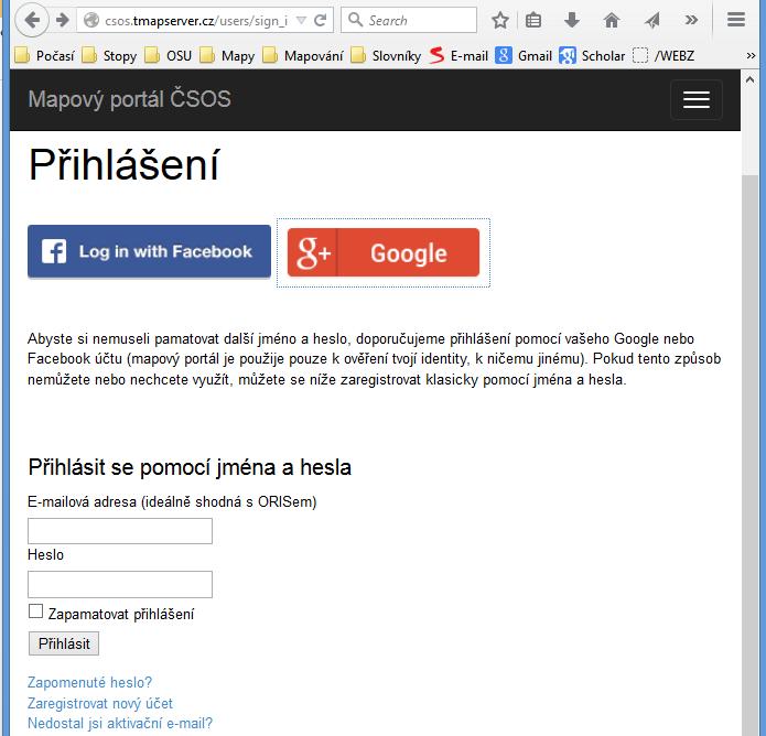
8 Login
 = here you can add old map which is missing in archive Moje mapy (My maps) = list of all your maps (registered maps, added")
9 Menu Moje stránka (My page = users profile, roles, identity in ORIS) Ohlásit připravovanou mapu (Notify new map) = here you get registration number Přidat mapu (Add map) = here you can add old map which is missing in archive Moje mapy (My maps) = list of all your maps (registered maps, added maps)

10 Notify new map

11 Map outline is drawn by user Kliknutím na Uložit ve spodní části stránky je záznam uložen a zažádáno o evidenční číslo mapy.

12 Completed request for registration of new map

13 After competition organizers till 30 days after competition organizers must fill metadata in system and send mandatory prints to archive it is easy to fill, just click button and fill several fields
14 What metadata we collect

15 It is possible to attach map file PDF, TIFF, JPEG. Recommended resolution 300 dpi. before making public at the server, map previews are automatically resampled to 96 dpi and provided with protective watermark

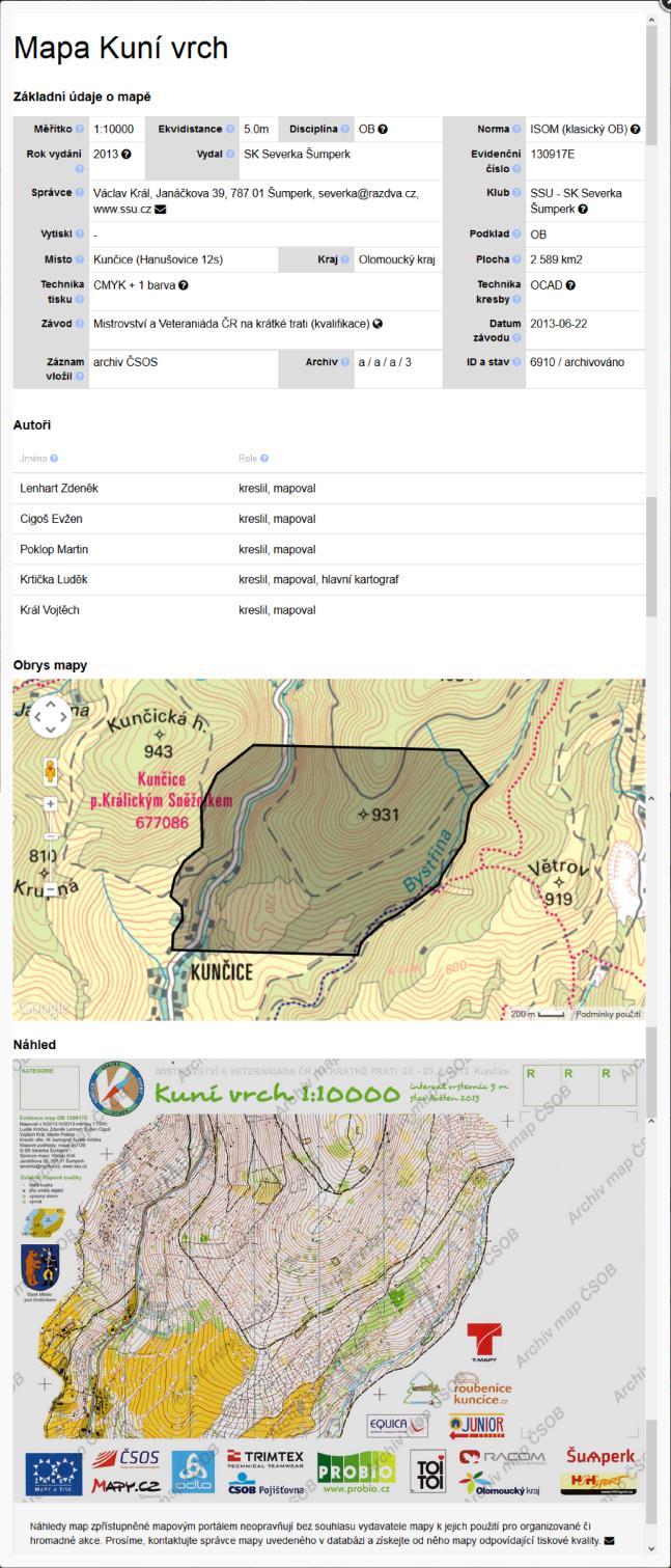
16 Map record
17 Technical solution Map portal is web application, everything (metadata, map outlines and map previews) is stored in PostgreSQL DB. For visualization of spatial data Google Maps API and Google Fusion Tables are used, web application is implemented in Ruby on Rails Main pros are on-line editing, central registration of maps and connection to other information systems of Czech O-Federation (ORIS, OB postupy, Výběrová řízení), saves lot of time for Archive administrator.
18 What does archive administrator now checks filled data and if outline of map is correct acquires archive scan of the map (TIFF, 300 dpi) sorts the prints into the series of archive submit additions to cooperating institutions
19 In terms of time Outline and basic metadata of new map are published immediately All metadata and map preview are published immediately after being added by organizer (till 30 days from competition) Archivation process is completed when paper prints reach Map archive and administrator scans them (depends on administrator time availability, usually till 3 months).

20 Archivation of original prints Original prints are most important part of archive In 2015 we were successful in negotiations with The National Archives due to high quality of our metadata and organization of archive. 3rd serie of Map archive is thus part of heritage we maintan for future generations in National Archives
21 Map archive in numbers 8300 maps produced till today more than 2200 map authors in registry increments 400 to 450 maps annually orienteering maps cover approx. 10 % of Czech Republic!
22 Future development greater focus on storing of digital originals (print PDFs exported from OCAD/Mapper, high resolution rasters) interconnection with social networks special collections (e.g. school maps)
23 Visit Map portal and see what is in the archive!
CHEMICAL INVENTORY ENTRY GUIDE
 CHEMICAL INVENTORY ENTRY GUIDE Version Date Comments 1 October 2013 Initial A. SUMMARY All chemicals located in research and instructional laboratories at George Mason University are required to be input
USAGE OF OLD MAPS AND THEIR DISTRIBUTION WITHIN THE FRAME OF WEB MAP SERVICES
 USAGE OF OLD MAPS AND THEIR DISTRIBUTION WITHIN THE FRAME OF WEB MAP SERVICES Jiri Cajthaml, Jiri Krejci Czech Technical University in Prague, Faculty of Civil Engineering, Department of Mapping and Cartography,
ON SITE SYSTEMS Chemical Safety Assistant
 ON SITE SYSTEMS Chemical Safety Assistant CS ASSISTANT WEB USERS MANUAL On Site Systems 23 N. Gore Ave. Suite 200 St. Louis, MO 63119 Phone 314-963-9934 Fax 314-963-9281 Table of Contents INTRODUCTION
Gridded Ambient Air Pollutant Concentrations for Southern California, User Notes authored by Beau MacDonald, 11/28/2017
 Gridded Ambient Air Pollutant Concentrations for Southern California, 1995-2014 User Notes authored by Beau, 11/28/2017 METADATA: Each raster file contains data for one pollutant (NO2, O3, PM2.5, and PM10)
Performing Advanced Cartography with Esri Production Mapping
 Esri International User Conference San Diego, California Technical Workshops July 25, 2012 Performing Advanced Cartography with Esri Production Mapping Tania Pal & Madhura Phaterpekar Agenda Outline generic
Please click the link below to view the YouTube video offering guidance to purchasers:
 Guide Contents: Video Guide What is Quick Quote? Quick Quote Access Levels Your Quick Quote Control Panel How do I create a Quick Quote? How do I Distribute a Quick Quote? How do I Add Suppliers to a Quick
Performing Map Cartography. using Esri Production Mapping
 AGENDA Performing Map Cartography Presentation Title using Esri Production Mapping Name of Speaker Company Name Kannan Jayaraman Agenda Introduction What s New in ArcGIS 10.1 ESRI Production Mapping Mapping
Arboretum Explorer: Using GIS to map the Arnold Arboretum
 Arboretum Explorer: Using GIS to map the Arnold Arboretum Donna Tremonte, Arnold Arboretum of Harvard University 2015 Esri User Conference (UC), July 22, 2015 http://arboretum.harvard.edu/explorer Mission
Learning ArcGIS: Introduction to ArcCatalog 10.1
 Learning ArcGIS: Introduction to ArcCatalog 10.1 Estimated Time: 1 Hour Information systems help us to manage what we know by making it easier to organize, access, manipulate, and apply knowledge to the
Frequently Asked Questions
 Frequently Asked Questions Can I still get paid via direct deposit? Can I use e- wallet to pay for USANA auto ship orders? Can I use e- wallet to pay for USANA products? Can I use e- wallet to pay for
What could you use to indicate historical earth conditions?
 03 22 2014 What could you use to indicate historical earth conditions? Deeds, Plats, Surveys Aerials Topography Soils Rainfall http://search.gsccca.org/plat/bookpagesearch.asp Google Earth as aerial previewer
REPLACE DAMAGED OR MISSING TEXTBOOK BARCODE LABEL
 Destiny Textbook Manager allows users to create and print replacement barcode labels for textbooks. In this tutorial you will learn how to: Replace damaged textbook barcode label(s) Replace missing textbook
Lesser Sunda - Banda Seascape Atlas
 Lesser Sunda - Banda Seascape Atlas Report prepared for the development of online interactive map for Lesser Sunda Banda Seascape by WorldFish December 2014 http://sbsatlas.reefbase.org Page 1 of 8 Table
Institute of Statistical and Geographical Information of Jalisco State Subnational Statistical and Geographical System India.
 Institute of Statistical and Geographical Information of Jalisco State Subnational Statistical and Geographical System India. January 2017 Subnational Statistical and Geographical System National Statistical
Export Basemap Imagery from GIS to CAD
 Export Basemap Imagery from GIS to CAD This tutorial illustrates how to add high resolution imagery as a basemap into an existing CAD drawing using ArcGIS and AutoCAD. Through this method, the imagery
ArcGIS Enterprise: What s New. Philip Heede Shannon Kalisky Melanie Summers Shreyas Shinde
 ArcGIS Enterprise: What s New Philip Heede Shannon Kalisky Melanie Summers Shreyas Shinde ArcGIS Enterprise is the new name for ArcGIS for Server ArcGIS Enterprise Software Components ArcGIS Server Portal
Managing Imagery and Raster Data Using Mosaic Datasets
 Esri International User Conference San Diego, California Technical Workshops July 25, 2012 Managing Imagery and Raster Data Using Mosaic Datasets Hong Xu, Prashant Mangtani Presentation Overview Introduction
Iowa Department of Transportation Office of Transportation Data GIS / CAD Integration
 Iowa Department of Transportation Office of Transportation Data GIS / CAD Integration From GIS data to CAD graphics - Iowa DOT's workflow utilizing GeoMedia and MicroStation to develop map products. Mark
Data-Sharing Agreement
 Data-Sharing Agreement Contributions to LandMark: The Global Platform of Indigenous and Community Lands This Data-Sharing Agreement provides the standards for contributing data to the LandMark: The Global
Frequently Asked Questions about MnDOT s Railroad Map Conversion Project
 Frequently Asked Questions about MnDOT s Railroad Map Conversion Project What were the main objectives of the project? What are the results and end products? What can these railroad maps be used for? Who
METHODS FOR STATISTICS
 DYNAMIC CARTOGRAPHIC METHODS FOR VISUALIZATION OF HEALTH STATISTICS Radim Stampach M.Sc. Assoc. Prof. Milan Konecny Ph.D. Petr Kubicek Ph.D. Laboratory on Geoinformatics and Cartography, Department of
Spatial Statistical Information Services in KOSTAT
 Distr. GENERAL WP.30 12 April 2010 ENGLISH ONLY UNITED NATIONS ECONOMIC COMMISSION FOR EUROPE (UNECE) CONFERENCE OF EUROPEAN STATISTICIANS EUROPEAN COMMISSION STATISTICAL OFFICE OF THE EUROPEAN UNION (EUROSTAT)
Spatial Asset Management
 Spatial Asset Management What can Maximo do for you? Jeremy Myers www.cohesivesolutions.com Today s Topics What is Maximo Spatial High Level Architecture Using Spatial Configuration Capabilities Use Case
Lecture 9: Reference Maps & Aerial Photography
 Lecture 9: Reference Maps & Aerial Photography I. Overview of Reference and Topographic Maps There are two basic types of maps? Reference Maps - General purpose maps & Thematic Maps - maps made for a specific
WeatherHawk Weather Station Protocol
 WeatherHawk Weather Station Protocol Purpose To log atmosphere data using a WeatherHawk TM weather station Overview A weather station is setup to measure and record atmospheric measurements at 15 minute
INSPIRE in Sweden.
 INSPIRE in Sweden Swedish National Data Service Established 2008. SND is a service organisation for Swedish research within the Humanities, Social Sciences and Medicine. SND is the Swedish node in an international
A powerful site for all chemists CHOICE CRC Handbook of Chemistry and Physics
 Chemical Databases Online A powerful site for all chemists CHOICE CRC Handbook of Chemistry and Physics Combined Chemical Dictionary Dictionary of Natural Products Dictionary of Organic Dictionary of Drugs
Digital Cartography in the Royal Library - the National Library of Sweden
 LIBER QUARTERLY, ISSN 1435-5205 LIBER 1999. All rights reserved K.G. Saur, Munich. Printed in Germany Digital Cartography in the Royal Library - the National Library of Sweden by GÖRAN BÄÄRNHIELM Digital
Bentley Map Advancing GIS for the World s Infrastructure
 Bentley Map Advancing GIS for the World s Infrastructure Presentation Overview Why would you need Bentley Map? What is Bentley Map? Where is Bentley Map Used? Red text signifies new things in Bentley Map
Geospatial Products V8i (SELECTseries 1)
") Geospatial Products V8i (SELECTseries 1) Keith Raymond Product Manager Geospatial Desktop Products Presentation Overview What are the various products? Why would you need them? Demonstrations 2 WWW.BENTLEY.COM
Geospatial Products V8i (SELECTseries 1) Keith Raymond Product Manager Geospatial Desktop Products Presentation Overview What are the various products? Why would you need them? Demonstrations 2 WWW.BENTLEY.COM
Evaluating Physical, Chemical, and Biological Impacts from the Savannah Harbor Expansion Project Cooperative Agreement Number W912HZ
 Evaluating Physical, Chemical, and Biological Impacts from the Savannah Harbor Expansion Project Cooperative Agreement Number W912HZ-13-2-0013 Annual Report FY 2018 Submitted by Sergio Bernardes and Marguerite
EuroSDR Historical data Seminar specific projects. 17. Oktober H. Gollin. armasuisse. Bundesamt für Landestopografie swisstopo
 armasuisse EuroSDR Historical data Seminar specific projects 17. Oktober 2014 H. Gollin Topics «Journey through time» «LUBIS» «Ellipse» Archiving of geodata 2 Historical maps Key data foundation in 1838
EXPLANATION OF G.I.S. PROJECT ALAMEIN FOR WEB PUBLISHING
 EXPLANATION OF G.I.S. PROJECT ALAMEIN FOR WEB PUBLISHING Compilato: Andrea De Felici Rivisto: Approvato: Daniele Moretto ARIDO S President Versione: 1.0 Distribuito: 28/06/2013 1 TABLE OF CONTENTS 1. INTRODUCTION..3
University of Colorado Denver Anschutz Medical Campus Online Chemical Inventory System User s Manual
 University of Colorado Denver Anschutz Medical Campus Online Chemical Inventory System User s Manual Hazardous Materials Division 303-724-0345 chemical.inventory@ucdenver.edu May, 2017 Table of Contents
egeo.ch WebGIS an Internet GIS framework for the Swiss federal administrations based on CartoWeb, Mapserver and PostGIS
 egeo.ch WebGIS an Internet GIS framework for the Swiss federal administrations based on CartoWeb, Mapserver and PostGIS Sylvain Pasche Camptocamp SA PSE C CH-1015 Lausanne Switzerland info@camptocamp.com
Defense Acquisition University
 STEP 1 STEP 2 STEP 3 STEP 4 STEP 5 STEP 6 Search For Training Take DAU Orientation Take Online Training Take Instructor-Led Training Edit Your User Record View Your Course Completions Defense Acquisition
mylab: Chemical Safety Module Last Updated: January 19, 2018
 : Chemical Safety Module Contents Introduction... 1 Getting started... 1 Login... 1 Receiving Items from MMP Order... 3 Inventory... 4 Show me Chemicals where... 4 Items Received on... 5 All Items... 5
New SPOT Program. Customer Tutorial. Tim Barry Fire Weather Program Leader National Weather Service Tallahassee
 New SPOT Program Customer Tutorial Tim Barry Fire Weather Program Leader National Weather Service Tallahassee tim.barry@noaa.gov Live Demonstration http://www.weather.gov/spot/ Live Demonstration http://www.weather.gov/spot/
Journal of e-media Studies Volume 3, Issue 1, 2013 Dartmouth College
 Journal of e-media Studies Volume 3, Issue 1, 2013 Dartmouth College Review of Old Maps Online Alyssa McLeod Labeled Google for old maps by its creators, the Jisc-funded Old Maps Online is an interface
THE NATIONAL ATLAS OF SPAIN ( ): FACSIMILE DIGITAL VERSION
: FACSIMILE DIGITAL VERSION") THE NATIONAL ATLAS OF SPAIN (1986-2008): FACSIMILE DIGITAL VERSION Abstract Pilar Sánchez-Ortiz Rodríguez Instituto Geográfico Nacional. Ministerio de Fomento General Ibáñez Ibero, 3 28003 Madrid (Spain)
THE NATIONAL ATLAS OF SPAIN (1986-2008): FACSIMILE DIGITAL VERSION Abstract Pilar Sánchez-Ortiz Rodríguez Instituto Geográfico Nacional. Ministerio de Fomento General Ibáñez Ibero, 3 28003 Madrid (Spain)
INTRODUCTION TO GIS. Dr. Ori Gudes
 INTRODUCTION TO GIS Dr. Ori Gudes Outline of the Presentation What is GIS? What s the rational for using GIS, and how GIS can be used to solve problems? Explore a GIS map and get information about map
Bloomsburg University Weather Viewer Quick Start Guide. Software Version 1.2 Date 4/7/2014
 Bloomsburg University Weather Viewer Quick Start Guide Software Version 1.2 Date 4/7/2014 Program Background / Objectives: The Bloomsburg Weather Viewer is a weather visualization program that is designed
PPT Slide. Slide 1 of 32. Notes:
 Slide 1 of 32 This presentaion will describe the background of establishing an agricultural district in Westchester County and how GIS was used to map the district. file:///volumes/web/www/ce/conferences/gis%20present/testfarm/sld001.htm[4/6/11
Integrating LiDAR data into the workflow of cartographic representation.
 Integrating LiDAR data into the workflow of cartographic representation. Cartographic Workflow I. 1 2 3 4 5 Surveying Vector (Nat. GDB) GPS, Laser Range Finder Yes/ No Scanning old maps LiDARflights Capture
DP Project Development Pvt. Ltd.
 Dear Sir/Madam, Greetings!!! Thanks for contacting DP Project Development for your training requirement. DP Project Development is leading professional training provider in GIS technologies and GIS application
Archiving orienteering maps - project in Slovenia
 18th International Conference on Orienteering Mapping (ICOM) October 5, 2018, Prague, Czech Republic Archiving orienteering maps - project in Slovenia Dušan Petrovič University of Ljubljana, Slovenian
Sell2Wales Supplier User Guide Quick Quote
 Sell2Wales Supplier User Guide Quick Quote Table of Contents What is Quick Quote?... 2 How do I get selected for a Quick Quote?... 2 How do I access my Quick Quote?... 2 How do I know I ve been invited
ArcGIS Earth for Enterprises DARRON PUSTAM ARCGIS EARTH CHRIS ANDREWS 3D
 ArcGIS Earth for Enterprises DARRON PUSTAM ARCGIS EARTH CHRIS ANDREWS 3D ArcGIS Earth is ArcGIS Earth is a lightweight globe desktop application that helps you explore any part of the world and investigate
What s New. August 2013
 What s New. August 2013 Tom Schwartzman Esri tschwartzman@esri.com Esri UC2013. Technical Workshop. What is new in ArcGIS 10.2 for Server ArcGIS 10.2 for Desktop Major Themes Why should I use ArcGIS 10.2
Geodatabase Best Practices. Dave Crawford Erik Hoel
 Geodatabase Best Practices Dave Crawford Erik Hoel Geodatabase best practices - outline Geodatabase creation Data ownership Data model Data configuration Geodatabase behaviors Data integrity and validation
GPS Mapping with Esri s Collector App. What We ll Cover
 GPS Mapping with Esri s Collector App Part 1: Overview What We ll Cover Part 1: Overview and requirements Part 2: Preparing the data in ArcGIS for Desktop Part 3: Build a web map in ArcGIS Online Part
When Map Quality Matters
 When Map Quality Matters 50% 25% Powerful geospatial mapping tools for Adobe Creative Cloud and offline map solutions for mobile devices 20% When Map Quality Matters 10% We re focused on creating powerful
ATLAS of Biochemistry
 ATLAS of Biochemistry USER GUIDE http://lcsb-databases.epfl.ch/atlas/ CONTENT 1 2 3 GET STARTED Create your user account NAVIGATE Curated KEGG reactions ATLAS reactions Pathways Maps USE IT! Fill a gap
Data-Sharing Agreement
 Data-Sharing Agreement Contributions to LandMark: The Global Platform of Indigenous and Community Lands This Data-Sharing Agreement provides the standards for contributing data to the LandMark: The Global
Gridded Traffic Density Estimates for Southern
 Gridded Traffic Density Estimates for Southern California, 1995-2014 User Notes authored by Beau, 11/28/2017 METADATA: Each raster file contains Traffic Density data for one year (1995, 2000, 2005, 2010,
Evaluating e-government : implementing GIS services in Municipality
 Evaluating e-government : implementing GIS services in Municipality Municipality of Thessaloniki - G.I.S. Unit Misirloglou Symeon Head of the GIS Unit ESRI UC - 2016 The GIS Section - subset of the department
Incorporating ArcGIS Pro in your Curriculum
 AAG, Boston 2017 April 5, 2017 Incorporating ArcGIS Pro in your Curriculum Geri Miller Agenda Concerns Acknowledged Learning curve ArcGIS Pro does not have all the tools (perception) Licensing and offline
NC Geospatial Data Archiving Project
 NC Geospatial Data Archiving Project 1. Frequency of Capture of Geospatial Data We seek your advice and experience in creating geospatial data snapshots for your archives -- versions of vector data and
ArcGIS is Advancing. Both Contributing and Integrating many new Innovations. IoT. Smart Mapping. Smart Devices Advanced Analytics
 ArcGIS is Advancing IoT Smart Devices Advanced Analytics Smart Mapping Real-Time Faster Computing Web Services Crowdsourcing Sensor Networks Both Contributing and Integrating many new Innovations ArcGIS
Jo Daviess County Geographic Information System
 Introduction The Jo Daviess County Geographic Information System (GIS) offers a wide variety of products and services. The GIS program has a cost recovery policy in place to help maintain and continue
Digital Tax Maps Westport Island Project Summary
 Digital Tax Maps Westport Island Project Summary Presented to the: Mid-Coast Regional Planning Commission Creating GIS-Based Digital Tax Maps And Linked Assessment Records For Small Towns on a Budget Dennis
The ecadastre System. Francis KAELL ecadastre project manager
 The ecadastre System Francis KAELL ecadastre project manager ecadastre what s that? A mapping tool to view, combine and analyze geodata in a browser A product catalogue which describes all the available
Economic and Social Council
 United Nations Economic and Social Council Distr.: General 23 May 2012 Original: English E/CONF.101/100 Tenth United Nations Conference on the Standardization of Geographical Names New York, 31 July 9
Introduction to Portal for ArcGIS. Hao LEE November 12, 2015
 Introduction to Portal for ArcGIS Hao LEE November 12, 2015 Agenda Web GIS pattern Product overview Installation and deployment Security and groups Configuration options Portal for ArcGIS + ArcGIS for
Spatial Data Infrastructure Concepts and Components. Douglas Nebert U.S. Federal Geographic Data Committee Secretariat
 Spatial Data Infrastructure Concepts and Components Douglas Nebert U.S. Federal Geographic Data Committee Secretariat August 2009 What is a Spatial Data Infrastructure (SDI)? The SDI provides a basis for
Overview. Everywhere. Over everything.
 Cadenza Desktop Cadenza Web Cadenza Mobile Cadenza Overview. Everywhere. Over everything. The ultimate GIS and reporting suite. Provide, analyze and report data efficiently. For desktop, web and mobile.
One platform for desktop, web and mobile
 One platform for desktop, web and mobile Search and filter Get access to all data thematically filter data in context factually and spatially as well as display it dynamically. Export a selection or send
SpyMeSat Mobile App. Imaging Satellite Awareness & Access
 SpyMeSat Mobile App Imaging Satellite Awareness & Access Imaging & Geospatical Technology Forum ASPRS Annual Conference March 12-16, 2017 Baltimore, MD Ella C. Herz 1 Orbit Logic specializes in software
TERMS OF REFERENCE FOR PROVIDING THE CONSULTANCY SERVICES OF
 1 Cartographic Database and TM100 Product Specifications TERMS OF REFERENCE FOR PROVIDING THE CONSULTANCY SERVICES OF Production and establishment of cartographic database for scale 1:100,000 and production
CREATING CUSTOMIZED DATE RANGE COLLECTIONS IN PRESENTATION STUDIO
 CREATING CUSTOMIZED DATE RANGE COLLECTIONS IN PRESENTATION STUDIO Date range collections are pre-defined reporting periods for performance data. You have two options: Dynamic date ranges automatically
Flood Database for Oklahoma: A web-mapping application for spatial data organization and access
 Flood Database for Oklahoma: A web-mapping application for spatial data organization and access Developed in partnership with the Oklahoma Department of Transportation Bridge and Survey Divisions S. Jerrod
SteelSmart System Cold Formed Steel Design Software Download & Installation Instructions
 Step 1 - Login or Create an Account at the ASI Portal: Login: https://portal.appliedscienceint.com/account/login Create Account: https://portal.appliedscienceint.com/account/register 2 0 1 7 A p p l i
VCCS Geospatial Institute 2011
 John McGee Jennifer McKee With support from: NSF DUE-0903270 Acquiring and Downloading Digital Data in partnership with: Geospatial Technician Education Through Virginia s Community Colleges (GTEVCC) Review
Bentley Map Advancing GIS for the World s Infrastructure
 Bentley Map Advancing GIS for the World s Infrastructure Presentation Overview Why would you need Bentley Map? What is Bentley Map? Where is Bentley Map Used? Why would you need Bentley Map? Because your
ST-Links. SpatialKit. Version 3.0.x. For ArcMap. ArcMap Extension for Directly Connecting to Spatial Databases. ST-Links Corporation.
 ST-Links SpatialKit For ArcMap Version 3.0.x ArcMap Extension for Directly Connecting to Spatial Databases ST-Links Corporation www.st-links.com 2012 Contents Introduction... 3 Installation... 3 Database
Preventing Misuse of GIS Data and Products. Preventing Misuse of GIS Data and Products
 Preventing Misuse of GIS Data and Products Goals & Objectives Review and discuss the following History behind this effort Minimum metadata standards Standard disclaimers for data and products Guidelines
February 7, Jay Krafthefer, L.S.
 February 7, 2013 Jay Krafthefer, L.S. Introduction Background Web applications References Maps released on the Internet self-service not filed for record referenced by Commissioner s orders (Minn. Statute
CHAPTER 22 GEOGRAPHIC INFORMATION SYSTEMS
 CHAPTER 22 GEOGRAPHIC INFORMATION SYSTEMS PURPOSE: This chapter establishes the administration and use of to improve the quality and accessibility of Department s spatial information and support graphical
Office of Technology Partnerships GIS Collaboration
 Office of Technology Partnerships GIS Collaboration State GIS Update April 21, 2017 Mark Holmes, GISP Outline MGF Upgrade Project Census Programs Imagery Update LiDAR Update Open Discussion 2 MGF Background
STATE GEOGRAPHIC INFORMATION DATABASE
 STATE GEOGRAPHIC INFORMATION DATABASE Data Information and Knowledge Management STATE GEOGRAPHIC INFORMATION DATABASE EXECUTIVE SUMMARY Utah has developed one of the most comprehensive statewide GIS resources
USGS QUADRANGLES IN GOOGLE EARTH
 USGS QUADRANGLES IN GOOGLE EARTH By Thomas G. Davis 1, PhD, PE, PLS and Rollins Turner 2, PhD INTRODUCTION QUADS (http://www.metzgerwillard.us/quads/) is a web-based service for visualizing USGS quadrangle
EYE-TRACKING TESTING OF GIS INTERFACES
 Geoinformatics EYE-TRACKING TESTING OF GIS INTERFACES Bc. Vaclav Kudelka Ing. Zdena Dobesova, Ph.D. Department of Geoinformatics, Palacký University, Olomouc, Czech Republic ABSTRACT Eye-tracking is currently
Management of Geological Information for Mining Sector Development and Investment Attraction Examples from Uganda and Tanzania
 Mineral Wealth Conference 2016 Kampala / Uganda Management of Geological Information for Mining Sector Development and Investment Attraction Examples from Uganda and Tanzania Andreas Barth 1, Andreas Knobloch
Web GIS Deployment for Administrators. Vanessa Ramirez Solution Engineer, Natural Resources, Esri
 Web GIS Deployment for Administrators Vanessa Ramirez Solution Engineer, Natural Resources, Esri Agenda Web GIS Concepts Web GIS Deployment Patterns Components of an On-Premises Web GIS Federation of Server
ArcGIS 9 ArcGIS StreetMap Tutorial
 ArcGIS 9 ArcGIS StreetMap Tutorial Copyright 2001 2008 ESRI All Rights Reserved. Printed in the United States of America. The information contained in this document is the exclusive property of ESRI. This
GIS ADMINISTRATOR / WEB DEVELOPER EVANSVILLE-VANDERBURGH COUNTY AREA PLAN COMMISSION
 GIS ADMINISTRATOR / WEB DEVELOPER EVANSVILLE-VANDERBURGH COUNTY AREA PLAN COMMISSION SALARY RANGE INITIATION $43,277 SIX MONTHS $45,367 POSITION GRADE PAT VI The Evansville-Vanderburgh County Area Plan
From Geographics Stella to Bentley Map Stella Map. Kimmo Soukki, Account Manager Bentley Finland
 From Geographics Stella to Bentley Map Stella Map Kimmo Soukki, Account Manager Bentley Finland This presentation Stella? Why migrate? New Bentley Stella Map - How it is done? Data migration Bonuses? What
Bentley Map V8i (SELECTseries 3)
") Bentley Map V8i (SELECTseries 3) A quick overview Why Bentley Map Viewing and editing of geospatial data from file based GIS formats, spatial databases and raster Assembling geospatial/non-geospatial data
Bentley Map V8i (SELECTseries 3) A quick overview Why Bentley Map Viewing and editing of geospatial data from file based GIS formats, spatial databases and raster Assembling geospatial/non-geospatial data
Town of Taos Request for Proposal Historic Preservation GIS Geodatabase Project April 2007
 Town of Taos Request for Proposal Historic Preservation GIS Geodatabase Project April 2007 1. Background The Town of Taos is requesting proposals from qualified firms or a team of firms who can develop
ArcGIS for Desktop. ArcGIS for Desktop is the primary authoring tool for the ArcGIS platform.
 ArcGIS for Desktop ArcGIS for Desktop ArcGIS for Desktop is the primary authoring tool for the ArcGIS platform. Beyond showing your data as points on a map, ArcGIS for Desktop gives you the power to manage
No. of Days. ArcGIS 3: Performing Analysis ,431. Building 3D cities Using Esri City Engine ,859
 What s New? Creating Story Maps with ArcGIS Field Data Collection and Management Using ArcGIS Get Started with Insights for ArcGIS Introduction to GIS Using ArcGIS & ArcGIS Pro: Essential Workflow Migrating
No. of Days. ArcGIS Pro for GIS Professionals ,431. Building 3D cities Using Esri City Engine ,859
 What s New? Creating Story Maps with ArcGIS Field Data Collection and Management Using ArcGIS Get Started with Insights for ArcGIS Introduction to GIS Using ArcGIS & ArcGIS Pro: Essential Workflow Migrating
ArcGIS Enterprise: Administration Workflows STUDENT EDITION
 ArcGIS Enterprise: Administration Workflows STUDENT EDITION Copyright 2019 Esri All rights reserved. Course version 1.1. Version release date April 2019. Printed in the United States of America. The information
Table of content. Understanding workflow automation - Making the right choice Creating a workflow...05
 Marketers need to categorize their audience to maximize their r e a c h. Z o h o C a m p a i g n s a u t o m a t e s r e c i p i e n t c l a s s i fi c a t i o n a n d action performance to free up marketers
Cerno Application Note Extending the Limits of Mass Spectrometry
 Creation of Accurate Mass Library for NIST Database Search Novel MS calibration has been shown to enable accurate mass and elemental composition determination on quadrupole GC/MS systems for either molecular
Smart Data Collection and Real-time Digital Cartography
 Smart Data Collection and Real-time Digital Cartography Yuji Murayama and Ko Ko Lwin Division of Spatial Information Science Faculty of Life and Environmental Sciences University of Tsukuba IGU 2013 1
Yes, the Library will be accessible via the new PULSE and the existing desktop version of PULSE.
 F R E Q U E N T L Y A S K E D Q U E S T I O N S THE LIBRARY GENERAL W H A T I S T H E L I B R A R Y? The Library is the new, shorter, simpler name for the Business Development (Biz Dev) Library. It s your
Data Structures & Database Queries in GIS
 Data Structures & Database Queries in GIS Objective In this lab we will show you how to use ArcGIS for analysis of digital elevation models (DEM s), in relationship to Rocky Mountain bighorn sheep (Ovis
UTAH S STATEWIDE GEOGRAPHIC INFORMATION DATABASE
 UTAH S STATEWIDE GEOGRAPHIC INFORMATION DATABASE Data Information and Knowledge Management NASCIO Awards 2009 STATE GEOGRAPHIC INFORMATION DATABASE B. EXECUTIVE SUMMARY Utah has developed one of the most
Continental Divide National Scenic Trail GIS Program
 CDNST Vision Statement: Provide the most accurate geospatial locational information of the Continental Divide Trail and nearby resources to the public as well as help provide internal management information