Geospatial Information Management, a Feasible Tool for Small Island Developing States?
|
|
|
- Susanna Stewart
- 6 years ago
- Views:
Transcription
1 Geospatial Information Management, a Feasible Tool for Small Island Developing States? Hartmut Müller FIG Pacific Small Island Developing States Symposium, Policies and Practices for Responsible Governance September 2013, Suva, Fiji Technical Session 1A: FIG Commission 3 Technical Session: The Importance of Geospatial Information, 19 September 2013,
2


3


4
5 1 The Need for Geospatial Information Management an Example


6 Huge floodings in the world between 1985 and 2010

7 Tsunami 2004
8 Let s have a closer look Heavy rain Flooding? Which risk of flooding do we face? Which people possibly must be evacuated? Which roads likely will remain accessible? Where are the river courses? Which are the heights near the rivers? Where do people live? Where are the roads?

9 Let s have a closer look Where are the river courses? Which are the heights near the rivers? Where do people live? Where are the roads?
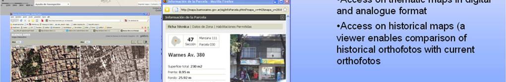
10 Let s have a closer look Where does these data exist? Can we use the data? Process Obtain the steps data from to be disparate skipped in an sources operating Geospatial Data Infrastructure Import and integrate the data in GIS Process the data in GIS Obtain needed information Make decisions May be very time consuming!
11 2 What is needed?
12 Geospatial Information Management builds on a Spatial Data Infrastructure The Spatial Data Infrastructure (SDI) provides a basis for spatial data discovery, evaluation, and application for users and providers within all levels of government, the commercial sector, the non-profit sector, academia and by citizens in general. Source: The SDI Cookbook - Global Spatial Data Infrastructure Association
13 Components of an SDI Discovery Access Processing S e r v i c e s Metadata Framework Spatial Data
14 3 What is available?


15 Standards Wordwide SDI Development Regional and National Initiatives in Europe, Australasia, the Americas, Africa, Middle East,


16


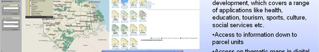
17 Public access to parcel information of the City of Buenos Aires


18 Digital Egypt (2009) WebGIS- Application launched in April 2009 Development of a private Egyptian company Covers Governorate of Cairo, cities of Sharm El Sheilh, Hurghada, the Northern Coast and 122 cities as point objects Search for real estate and properties Find businesses Locate streets and landmarks Measure distances and areas Obtain point coordinates


19 Digital Egypt (2009) Search for properties


20 Digital Egypt (2009) Search for landmarks


21 The European SDI Initiative INSPIRE Regional Spatial Data Infrastructure (RSDI) Area 4,4 Mio km² Population > 500 Mio
22 The European SDI Initiative INSPIRE Regional Spatial Data Infrastructure (RSDI) Purpose of INSPIRE to support environmental policy to overcome major barriers affecting the availability and accessibility of relevant data Barriers include Inconsistencies in spatial data collection (spatial data often missing or incomplete, same data collected twice or more by different organizations; Lack or incomplete documentation of available spatial data; Lack of compatibility among spatial datasets (datasets cannot be combined or used with other spatial datasets; Incompatible SDI initiatives within Member States that often function in isolation; Cultural, institutional, financial, and legal barriers preventing or delaying the sharing of existing spatial data. World Bank SDI Report, accessed 26 July 2013

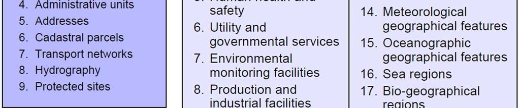
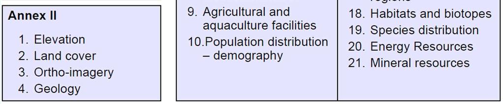
23 INSPIRE Themes
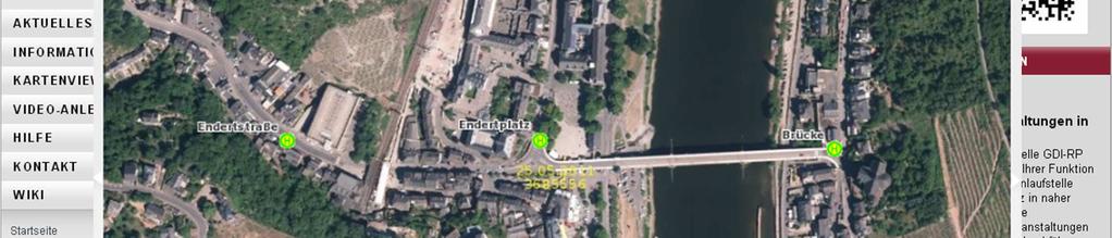
24 Cascading Services linking EU Regional level, National level and Local level SDI s one stop citizen interfaces
25 Cascading Services linking EU Regional level, National level and Local level SDI s EU Level DE Level DE_RLP Level DE_RLP_communal Level
26 SDI Germany within the European SDI framework Source: adapted from Schilcher et al. (2009) INSPIRE European SDI GDI-DE SDI Germany 1 Federation SDI 16 Federal State SDIs X Commune SDIs Other EU Member States SDIs


27 Source: Daniela Hogrebe, Andres von Dömming, Coordination Office SDI Germany


28 Cascading Services linking EU Regional level, National level and Local level SDI s EU Level DE Level DE_RLP Level DE_RLP_communal Level


29 Cascading Services linking EU Regional level, National level and Local level SDI s
, topographic map (half left), digital height")

30 Geospatial basic data countrywide available in Germany Digital orthophoto (left), topographic map (half left), digital height model (half right), digital landscape model (right) Source: Landesamt für Vermessung und Geobasisinformation Rheinland-Pfalz

31 one stop citizen interfaces

32 one stop citizen interfaces

33 one stop citizen interfaces


34
35 The European SDI Initiative INSPIRE Regional Spatial Data Infrastructure (RSDI) Lessons for SDI development in other countries Development of INSPIRE requires all member states to pass legislation and rules to match the EU Inspire SDI directive; build institutional and human capacity to undertake SDI; build 'metadata' information systems; support education and training of staff and citizens in SDI skills and awareness INSPIRE developes and uses many international technical standards potential benefit for SDI in developing countries; INSPIRE makes available verification and test services potential use by SDI in developing countries; Steps involved in building a SDI presented in the INSPIRE directive comprehensive check list for SDI development World Bank SDI Report, accessed 26 July 2013
36 The European SDI Initiative INSPIRE Regional Spatial Data Infrastructure (RSDI) Lessons for SDI development in other countries INSPIRE has stimulated a large amount of academic research, pilot studies, test-beds, on-line training materials technical relevance for other national and regional SDI's INSPIRE is a large, complex and costly initiative (co-ordination of 34 data themes, 28 sovereign countries, population > 500mio, multiple languages and legal systems) political, legal and administrative aspects likely to be different for other SDI's World Bank SDI Report, accessed 26 July 2013
37 Conclusion Geospatial Information Management, a feasible tool for Small Island Developing States? Everything happens somewhere Decision making has a spatial component Geospatial Information Management, a feasible tool for all states!


38 Thank you for your attention!
A Case Study on Local SDI Implementation in Germany
 A Case Study on Local SDI Implementation in Germany Hartmut MÜLLER, Falk WÜRRIEHAUSEN, Germany Key words: Local SDI, Municipality, Commune SDI, Geospatial Basic Data, Geospatial Thematic Data, Web Service,
GIS Building Communities beyond National Borders (Building Successful Spatial Data Infrastructures) Nick Land, ESRI Europe
 Nick Land, ESRI Europe") GIS Building Communities beyond National Borders (Building Successful Spatial Data Infrastructures) Nick Land, ESRI Europe UK worst flooding in the last 60 years 350,000 households without drinking water
GIS Building Communities beyond National Borders (Building Successful Spatial Data Infrastructures) Nick Land, ESRI Europe UK worst flooding in the last 60 years 350,000 households without drinking water
INSPIRE Basics. Vlado Cetl European Commission Joint Research Centre. https://ec.europa.eu/jrc/
 INSPIRE Basics Vlado Cetl European Commission Joint Research Centre https://ec.europa.eu/jrc/ Serving society Stimulating innovation Supporting legislation Outline SDI? Why European SDI? INSPIRE Policy
Roadmap to interoperability of geoinformation
 Roadmap to interoperability of geoinformation and services in Europe Paul Smits, Alessandro Annoni European Commission Joint Research Centre Institute for Environment and Sustainability paul.smits@jrc.it
Ministry of ICT of I.R.IRAN
 The ECO 8/6 mill km 2 10 Slamic countries ~330 mill people Oil, Gas, Industries,Tourism 2 Issue transformation in last decade Problem solving needs more integrated approach More interaction &complexity
GSDI Global Spatial Data Infrastructure. Convergences between Geo Spatial Communities: key decision for decision making
 GSDI Global Spatial Data Infrastructure Convergences between Geo Spatial Communities: key decision for decision making April 14 th 2010 Bas Kok GSDI Past-President Director of International Affairs, Dutch
Open spatial data infrastructure
 Open spatial data infrastructure a backbone for digital government Thorben Hansen Geomatikkdagene 2018 Stavanger 13.-15. mars Spatial Data Infrastructure definition the technology, policies, standards,
SDI Implementation at the Local Administration Level of Germany
 Hartmut MÜLLER and Stephan von St. VITH, Germany Key words: SDI, Municipality, egovernment, Geospatial Basic Data SUMMARY Germany is a federal republic consisting of 16 states (so called "Laender"). At
Who are we? Use of German State s Rhineland-Palatinate Spatial Data Infrastructure for e-government INSPIRE. Topics of Presentation INSPIRE
 Who are we? University of Applied Sciences, Mainz, Germany Institute for Spatial Information and Surveying Technology Use of German State s Rhineland-Palatinate Spatial Data Infrastructure for e-government
OPEN GOVERNMENT - BENEFITS OF INSPIRE IN THE PUBLIC SECTOR
 Brussels, 04th March 2013 - Daniela Hogrebe and André Caffier from GDI-DE 1 OPEN GOVERNMENT - BENEFITS OF INSPIRE IN THE PUBLIC SECTOR Powered by INSPIRE Open Government 2 SDI is a fundament of transparent
UN GGIM and National SDI Strategy
 MSDI Open Forum on 26 th January 2016 Contributing to the successful delivery of MSDI UN GGIM and National SDI Strategy Hiroshi Murakami Deputy Administrator Geospatial Information Authority of Japan Geospatial
Spatial Information Management in the Context of Organizational Development the Approach in North-Rhine Westphalia, Germany
 Spatial Information Management in the Context of Organizational Development the Approach in North-Rhine Westphalia, Germany Dr. Jens Riecken DVW Vice President c/o Ministry of the Interior North-Rhine
SDI-Challenges European perspective
 THE HIGH LEVEL FORUM ON GLOBAL GEOSPATIAL INFORMATION MANAGEMENT Seoul, Republic of Korea, 24-26 October 2011 Session 1: Challenges in geospatial policy formation and institutional arrangements SDI-Challenges
Spatial information for urban planning and management case study Zagreb Darko ŠIŠKO, Vlado CETL, Tomislav CICELI. Strasbourg, September 7th, 2017
 Spatial information for urban planning and management case study Zagreb Darko ŠIŠKO, Vlado CETL, Tomislav CICELI Strasbourg, September 7th, 2017 Contents: Cities & INSPIRE Cities in Croatian NSDI City
Building a national spatial data infrastructure. Thorben Hansen, Head of Division Danish Agency for Data Supply and Efficiency
 Building a national spatial data infrastructure Thorben Hansen, Head of Division Danish Agency for Data Supply and Efficiency About Spatial Data Infrastructure Spatial data come from many sources and is
INSPIRE - A Legal framework for environmental and land administration data in Europe
 INSPIRE - A Legal framework for environmental and land administration data in Europe Dr. Markus Seifert Bavarian Administration for Surveying and Cadastre Head of the SDI Office Bavaria Delegate of Germany
Adding value to Copernicus services with member states reference data
 www.eurogeographics.org Adding value to Copernicus services with member states reference data Neil Sutherland neil.sutherland@os.uk GIS in the EU 10 November 2016 Copyright 2016 EuroGeographics 61 member
Local Spatial Data Infrastructure, a Solid Base for Sustainable Land Management in Germany
 Local Spatial Data Infrastructure, a Solid Base for Sustainable Land Management in Germany FIG Commission 3 Workshop and Commission 3 Annual Meeting The Empowerment of Local Authorities: Spatial Information
SDI Implementation at the Local
 SDI Implementation at the Local Administration Level of Germany Hartmut Müller and Stephan von St. Vith FIG Working Week 2009 Surveyors Key Role in Accelerated Development, Eilat, Israel, 3-8 May 2009
Demonstration of a local SDI solution with several stakeholders in pilot areas in line with EU best practices
 EU Twinning project for the Agency of Land Relations and Cadaster (ALRC)- Organization, Streamlining and Computerization Process in Mapping in the Republic of Moldova. Demonstration of a local SDI solution
Status of implementation of the INSPIRE Directive 2016 Country Fiches. COUNTRY FICHE Ireland
 Status of implementation of the INSPIRE Directive 2016 Country Fiches COUNTRY FICHE Ireland Introduction... 1 1. State of Play... 2 1.1 Coordination... 2 1.2 Functioning and coordination of the infrastructure...
The future of SDIs. Ian Masser
 The future of SDIs Ian Masser Presentation Considers two questions relating to the future development of SDIs throughout the world Where have we got to now? Where should we go from here? Identifies four
Status of implementation of the INSPIRE Directive 2016 Country Fiches. COUNTRY FICHE Netherlands
 Status of implementation of the INSPIRE Directive 2016 Country Fiches COUNTRY FICHE Netherlands Introduction... 1 1. State of Play... 2 1.1 Coordination... 2 1.2 Functioning and coordination of the infrastructure...
Earth Observation and GEOSS in Horizon Copernicus for Raw Material Workshop 5 th September 2016
 Earth Observation and GEOSS in Horizon 2020 Copernicus for Raw Material Workshop 5 th September 2016 Gilles OLLIER Head of Sector -Earth observation Directorate Environment Unit I.4 Climate Actions and
Spatial Data Infrastructure in the Pacific
 Spatial Data Infrastructure in the Pacific. Sachindra Singh Senior Geospatial Systems Architect ICT for Development, Geoscience Division Pacific Community (SPC) OrganisationalBackground SPC - The Pacific
Status of implementation of the INSPIRE Directive 2016 Country Fiches. COUNTRY FICHE Finland
 Status of implementation of the INSPIRE Directive 2016 Country Fiches COUNTRY FICHE Finland Introduction... 1 1. State of Play... 2 1.1 Coordination... 2 1.2 Functioning and coordination of the infrastructure...
Compact guides GISCO. Geographic information system of the Commission
 Compact guides GISCO Geographic information system of the Commission What is GISCO? GISCO, the Geographic Information System of the COmmission, is a permanent service of Eurostat that fulfils the requirements
Implementing strategy for the Infrastructure for Spatial Information in Europe - INSPIRE Paul Smits
 Implementing strategy for the Infrastructure for Spatial Information in Europe - INSPIRE Paul Smits European Commission DG Joint Research Centre Institute for Environment and Sustainability Ispra, Italy
Spatially Enabled Society
 International Seminar on Land Administration Trends and Issues in Asia and the Pacific Region Spatially Enabled Society Abbas Rajabifard Vice Chair PCGIAP-WG3 Vice-President (President Elect), GSDI Association
The FIG - Questionnaire on NSDI
 The FIG - Questionnaire on NSDI Bernd Teichert University of Applied Sciences Dresden, Germany Contents NSDI - Definition Com. 3 - Brainstorming in Prague Canberra Implications and Conclusions The SDI
Global Spatial Data Infrastructure Association
 http://www.gsdi.org Global Spatial Data Infrastructure Association a global forum to support exchange of ideas and encourage joint activities at the global level Members: Think global, act local Organization:
NSDI Implementation. Milo Robinson FGDC. U. S. Policy OMB Circular A-16 From Global GSDI To Local Canadian/ U.S. Projects
 NSDI Implementation Milo Robinson FGDC U. S. Policy OMB Circular A-16 From Global GSDI To Local Canadian/ U.S. Projects Federal Geographic Data Committee (FGDC) A US Federal Interagency committee responsible
Towards Reliable Spatial Database of Informal Areas in Greater Cairo Region
 KEYWORDS informal areas, unreliable spatial data, spatial data collecting, capacity building SUMMARY The uncontrolled and rapid increase of Egypt s cities is a major problem of the country. More than the
SDI Development in Georgia. Mari Khardziani Head of International Relations Unit National Agency of Public Registry
 SDI Development in Georgia Mari Khardziani Head of International Relations Unit National Agency of Public Registry Kehl, Germany September 5, 2017 2 National Agency of Public Registry Legal Entity of Public
Cooperation is the key, FIG can facilitate
 Cooperation is the key, FIG can facilitate Mikael Lilje Vice President 2017-2020 Head, Geodetic infrastructure, Swedish mapping, cadastral and land registration authority Presented at the GIS/RS Conference
INSPIRing Geospatial Framework For Local Administrations
 This project is financed by the European Union and the Republic of Turkey Presented at the FIG Congress 2018, May 6-11, 2018 in Istanbul, Turkey National Programme for Turkey 2010 Instrument for Pre-Accession
Major Opportunities in Spatial Data Infrastructure Communities
 Major Opportunities in Spatial Data Infrastructure Communities Bas Kok President GSDI June 17 th 2008 FIG Working Week: Integrating Generations 14-19 June 2008 Stockholm, Sweden http://www.gsdi.org 1 GSDI
Appropriation Directions for 2007
 INSPIRE in Sweden An Important Part of the National Geodata Strategy Monica Lagerqvist Nilsson Appropriation Directions for 2007 A commission to investigate the necessity to adjust the Swedish legislation
Case Studies on Mega Cities
 Case Studies on Mega Cities Paul Kelly Director, Spatial Strategies Pty Ltd Vice Chair FIG Commission 3 The Case Study Cities Hong Kong SAR, China (Q) Tokyo, Japan (Q) Seoul, Korea (Q) Istanbul, Turkey
SDI Developments in the World s Currently Existing Mega Cities
 SDI Developments in the World s Currently Existing Mega Cities Silke Boos and Hartmut Müller FIG Working Week 2009 Surveyors Key Role in Accelerated Development, Eilat, Israel, 3-8 May 2009 TS 1B SDI in
Land Use in the context of sustainable, smart and inclusive growth
 Land Use in the context of sustainable, smart and inclusive growth François Salgé Ministry of sustainable development France facilitator EUROGI vice president AFIGéO board member 1 Introduction e-content+
Evolution and development of National Spatial Data Infrastructure in Republic of Moldova
 Agency for Land Relations and Cadastre of the Republic of Moldova Evolution and development of National Spatial Data Infrastructure in Republic of Moldova Alexandru Morcov Deputy general director ALRC
Global Geospatial Information Management Country Report Finland. Submitted by Director General Jarmo Ratia, National Land Survey
 Global Geospatial Information Management Country Report Finland Submitted by Director General Jarmo Ratia, National Land Survey Global Geospatial Information Management Country Report Finland Background
Esri and GIS Education
 Esri and GIS Education Organizations Esri Users 1,200 National Government Agencies 11,500 States & Regional Agencies 30,800 Cities & Local Governments 32,000 Businesses 8,500 Utilities 12,600 NGOs 11,000
Report of the Regional Committee of UN-GGIM for Asia and the Pacific (UN-GGIM-AP)
") Report of the Regional Committee of UN-GGIM for Asia and the Pacific (UN-GGIM-AP) At the Eighth Session of UN-GGIM UN Headquarters, New York, 1 3 August 2018 About UN-GGIM-AP One of the five regional committees
Report of the Regional Committee of UN-GGIM for Asia and the Pacific (UN-GGIM-AP) At the Eighth Session of UN-GGIM UN Headquarters, New York, 1 3 August 2018 About UN-GGIM-AP One of the five regional committees
CES Seminar 2016: Geospatial information services based on official statistics Key issues from the session II papers
 Norbert Rainer 64 th plenary session of the Conference of European Statisticians 28 April 2016, Paris CES Seminar 2016: Geospatial information services based on official statistics Key issues from the
INSPIRATION results and benefits for the Agency for Real Estate Cadastre
 JOINT RESEARCH CENTER - E&I WORKSHOP INSPIRATION results and benefits for the Agency for Real Estate Cadastre Sonja Dimova, state advisor AGENCY FOR REAL ESTATE CADASTRE REPUBLIC OF MACEDONIA Wednesday,
The Integrated Ge spatial Information Framework to the strengthening of NSDI, Mongolia
 Young Geospatial Professionals Summit 21 NOV 2018 The Integrated Ge spatial Information Framework to the strengthening of NSDI, Mongolia BAYARMAA ENKHTUR Geospatial information and technology department
The Global Fundamental Geospatial Data Themes Journey. April Clare Hadley WG Chair
 The Global Fundamental Geospatial Data Themes Journey April 2018 Clare Hadley WG Chair The Road to here Why Global? Why Geospatial? Why Fundamental? Why Themes? The route we took Where does the road go
The Danish Maritime Spatial Data Infrastructure (MSDI) Geodata of the Sea
 Geodata of the Sea") MSDI/MSP The Danish Maritime Spatial Data Infrastructure (MSDI) Geodata of the Sea Components of an infrastructure: DATA - metadata, datasets FUNCTIONALITY - spatial data services, web services and other
MSDI/MSP The Danish Maritime Spatial Data Infrastructure (MSDI) Geodata of the Sea Components of an infrastructure: DATA - metadata, datasets FUNCTIONALITY - spatial data services, web services and other
Status of implementation of the INSPIRE Directive 2016 Country Fiches. COUNTRY FICHE Czech Republic
 Status of implementation of the INSPIRE Directive 2016 Country Fiches COUNTRY FICHE Czech Republic Introduction... 1 1. State of Play... 2 1.1 Coordination... 2 1.2 Functioning and coordination of the
Maanmittauspäivät 2018 Helsinki Maanmittauspäivät 2018 The Danish initiatives regarding open and free basic data including effect studies
 Maanmittauspäivät 2018 The Danish initiatives regarding open and free basic data including effect studies 22.03.2018 Agenda 1. Intro overall frame / selfie 2. Data Infrastructure 3. The Danish Digital
Upgrade the Datasets in NSDI for Smarter Services with the Cases of China
 Upgrade the Datasets in NSDI for Smarter Services with the Cases of China By Dr. JIANG Jie Dept of GeoInformaiton Service Platform National Geomatics Center of China October 7, 2015 Jeju, Republic of Korea
European Directive (2007/2/EC) INSPIRE sharing data in an interoperable way
 INSPIRE sharing data in an interoperable way") European Directive (2007/2/EC) INSPIRE sharing data in an interoperable way Robert Tomas 7 th European Conference on Regional Geoscientific Cartography and Information Systems Bologna, 12 th -15 th June
European Directive (2007/2/EC) INSPIRE sharing data in an interoperable way Robert Tomas 7 th European Conference on Regional Geoscientific Cartography and Information Systems Bologna, 12 th -15 th June
National Geospatial Platforms Solution to interoperability challenge in Europe. Antti Jakobsson Programme manager National Land Survey of Finland
 National Geospatial Platforms Solution to interoperability challenge in Europe Antti Jakobsson Programme manager National Land Survey of Finland 1 Questionnaire made in 2017: Google search: Public Geospatial
Status of implementation of the INSPIRE Directive 2016 Country Fiches. COUNTRY FICHE Malta
 Status of implementation of the INSPIRE Directive 2016 Country Fiches COUNTRY FICHE Malta Introduction... 1 1. State of Play... 2 1.1 Coordination... 2 1.2 Functioning and coordination of the infrastructure...
ESDIN Results from a Crossborder INSPIRE Preparatory Project. Jörgen Hartnor, Lantmäteriet.
 ESDIN Results from a Crossborder INSPIRE Preparatory Project Jörgen Hartnor, Lantmäteriet www.esdin.eu Ett econtentplus Best Practice Network projekt September 2008 February 2011 Coordinated by EuroGeographics
Challenges and Potentials of Place Based Information Management in Nepal"
 Nineteenth United Nations Regional Cartographic Conference for Asia and the Pacific, Bangkok, Thailand, 29 October 1 November 2012 Challenges and Potentials of Place Based Information Management in Nepal"
Sustainable and Harmonised Development for Smart Cities The Role of Geospatial Reference Data. Peter Creuzer
 Sustainable and Harmonised Development for Smart Cities The Role of Geospatial Reference Data Peter Creuzer 1. Introduction - Smart Cities and Geodata 2. Geodata in Germany 3. Examples 4. Data and Service
Update on INSPIRE; interoperable framework for natural hazards
 Update on INSPIRE; interoperable framework for natural hazards Robert Tomas EC-DG Joint Research Centre 16 th Meeting of Working Group F on Floods 2014, Rome www.jrc.ec.europa.eu Serving society Stimulating
Status of implementation of the INSPIRE Directive 2016 Country Fiches. COUNTRY FICHE Croatia
 Status of implementation of the INSPIRE Directive 2016 Country Fiches COUNTRY FICHE Croatia Introduction... 1 1. State of Play... 2 1.1 Coordination... 2 1.2 Functioning and coordination of the infrastructure...
The Global Statistical Geospatial Framework and the Global Fundamental Geospatial Themes
 The Global Statistical Geospatial Framework and the Global Fundamental Geospatial Themes Sub-regional workshop on integration of administrative data, big data and geospatial information for the compilation
Disaster Management in Mongolia
 The Third UN-GGIM-AP Plenary Meeting Disaster Management in Mongolia ~Coordination among NGIA & Other Related Organizations and Recommendations~ Bali Indonesia 10 November 2014 Khurelshagai Ayurzana, Director
Commercialisation. Lessons learned from Dutch weather market
 Commercialisation Lessons learned from Dutch weather market Where information comes together weather traffic public transport Weather, traffic and public transport. Daily actual information that influences
Proposal for a DIRECTIVE OF THE EUROPEAN PARLIAMENT AND OF THE COUNCIL. establishing an infrastructure for spatial information in the Community
 Proposal for a DIRECTIVE OF THE EUROPEAN PARLIAMENT AND OF THE COUNCIL establishing an infrastructure for spatial information in the Community INSPIRE http://inspire.jrc.it/ Alessandro Annoni 1 EU Commission
The Process of Spatial Data Harmonization in Italy. Geom. Paola Ronzino
 The Process of Spatial Data Harmonization in Italy Geom. Paola Ronzino ISSUES Geospatial Information in Europe: lack of data harmonization the lack of data duplication of data CHALLENGES Challenge of INSPIRE:
Open SDIs, Sustainable SDIs?
 Assessing the status of Open SDI/INSPIRE in Europe Open SDIs, Sustainable SDIs? EuroSDR workshop Sustainable open data business models for NMCAs 18 & 19 September 2017, Delft (the Netherlands) Glenn Vancauwenberghe
Development of a Unified Spatial Infrastructure Status Index for Developing Nations
 Development of a Unified Spatial Infrastructure Status Index for Developing Nations Mohamed ABDEL-SALAM, Canada and Mohamed MOSTAFA, Egypt Key words: Spatial information infrastructure, unified index,
Geography Policy 2014
 Geography Policy 2014 DEFINITION Geography education should inspire in pupils a curiosity and fascination about the world and its people that will remain with them for the rest of their lives. Teaching
Establishing the National Spatial Data Infrastructure (NSDI) for Norway a joint effort by many stakeholders SPATIAL DATA FOR BENEFIT OF THE SOCIETY
 for Norway a joint effort by many stakeholders SPATIAL DATA FOR BENEFIT OF THE SOCIETY") Establishing the National Spatial Data Infrastructure (NSDI) for Norway a joint effort by many stakeholders SPATIAL DATA FOR THE BENEFIT OF SOCIETY OUTLINE Political background Norway digital - The Norwegian
Establishing the National Spatial Data Infrastructure (NSDI) for Norway a joint effort by many stakeholders SPATIAL DATA FOR THE BENEFIT OF SOCIETY OUTLINE Political background Norway digital - The Norwegian
IHO STAKEHOLDERS FORUM. Hydrographic data and its role in MSDI. Thursday 27 September Jens Peter Hartmann KMS
 IHO STAKEHOLDERS FORUM Hydrographic data and its role in MSDI Thursday 27 September Jens Peter Hartmann KMS Agenda Traditional approach to hydrographic data Expectations within the marine / maritime field
Governance and performance of open spatial data policies in the context of INSPIRE
 Governance and performance of open spatial data policies in the context of INSPIRE Dr. Glenn Vancauwenberghe Delft University of Technology Dr. ir. Bastiaan van Loenen Delft University of Technology 1
GSDI: Towards a Spatially Enabled Society
 GSDI: Towards a Spatially Enabled Society Dr. David J. Coleman, President Global Spatial Data Infrastructure Association UN Regional Cartographic Conference for the Americas, United Nations, New York,
Analys av GIS-användning inom offentlig sektor i Norden
 Analys av GIS-användning inom offentlig sektor i Norden Henning Sten Hansen, Line Hvingel and Lise Schrøder Aalborg Universitet Jönköping, Sweden 30 March 2011 Overview The Danish and Swedish approaches
Exploring GIS Potential for Northwestern Ontario Land Information Ontario
 Exploring GIS Potential for Northwestern Ontario Land Information Ontario May 13, 2015 The LIO Vision LIO Vision: That all geographic information about Ontario is fully integrated and accessible LIO Goal:
EuroGeographics & INSPIRE. Nick Land, Executive Director of EuroGeographics
 EuroGeographics & INSPIRE Nick Land, Executive Director of EuroGeographics EuroGeographics A growing association 49 Members, 42 countries Topographic mapping, cadastre, land registry + Networked organisation
Economic and Social Council
 United Nations Economic and Social Council Distr.: General 18 July 2016 Original: English Committee of Experts on Global Geospatial Information Management Sixth session New York, 3-5 August 2016 Item 2
Voices from Private Sector: Insights for Future NSDI Development in Indonesia
 Voices from Private Sector: Insights for Future NSDI Development in Indonesia Ta n d a n g Yu l i a d i D w i P u t ra, Ryosuke S h i b a s a k i I n st i t u t e o f I n d u st r i a l S c i e n c e,
Fundamental Geospatial Data Themes
 Fundamental Geospatial Data Themes April 2016 Workshop Agenda Background why and how What is our objective? Fundamental data what are they? What are the candidate themes? Breakout Session Conclusion Background
INDONESIA S S UPDATE: GEOSPATIAL INFORMATION FOR SUSTAINABLE DEVELOPMENT RELATED TO INA SDI Dr. Asep Karsidi, M.Sc
 INDONESIA S S UPDATE: GEOSPATIAL INFORMATION FOR SUSTAINABLE DEVELOPMENT RELATED TO INA SDI Dr. Asep Karsidi, M.Sc GEOSPATIAL INFORMATION AGENCY 08 August, 2012 OUTLINE 1. Transformation Bakosurtanal into
I Background. Under the Cotton Tree: Situs Addressing System in Africa. Table of contents
 Cairo, April 2005 Under the Cotton Tree: Situs Addressing System in Africa Table of contents 1. Background 2. Current situation of addressing system in Africa 3. Benefits of a functional addressing system
Technical Specifications. Form of the standard
 Used by popular acceptance Voluntary Implementation Mandatory Legally enforced Technical Specifications Conventions Guidelines Form of the standard Restrictive Information System Structures Contents Values
ST AMBROSE CATHOLIC PRIMARY SCHOOL Geography Policy
 ST AMBROSE CATHOLIC PRIMARY SCHOOL Geography Policy 2017-2018 Our school policy is developed in accordance with the National Curriculum for Geography and Foundation Stage Curriculum for Understanding of
REGIONAL SDI DEVELOPMENT
 REGIONAL SDI DEVELOPMENT Abbas Rajabifard 1 and Ian P. Williamson 2 1 Deputy Director and Senior Research Fellow Email: abbas.r@unimelb.edu.au 2 Director, Professor of Surveying and Land Information, Email:
Collaborative Systems for the Creation of Marine Services
 Collaborative Systems for the Creation of Marine Services INSPIRE 2016 Nuno Almeida Nuno Catarino Barcelona, 28 th September 2016 Elecnor Deimos is a trademark which encompasses Elecnor Group companies
CLICK HERE TO KNOW MORE
 CLICK HERE TO KNOW MORE GeoSpace for Singapore s Whole-of-Government Data Sharing Asia GeoSpatial Forum 17 19 Oct 2011 Lee Kim Haw Singapore Land Authority Introducing Singapore Land Authority Limited
Data Origin. Ron van Lammeren CGI-GIRS 0910
 Data Origin Ron van Lammeren CGI-GIRS 0910 How to obtain geodata? Geo data initiative Executive Order 12906, "Coordinating Geographic Data Acquisition and Access: The National Spatial Data Infrastructure,"
INSPIREd solutions for Air Quality problems Alexander Kotsev
 INSPIREd solutions for Air Quality problems Alexander Kotsev www.jrc.ec.europa.eu Serving society Stimulating innovation Supporting legislation The European data puzzle The European data puzzle 24 official
GIS Geographical Information Systems. GIS Management
 GIS Geographical Information Systems GIS Management Difficulties on establishing a GIS Funding GIS Determining Project Standards Data Gathering Map Development Recruiting GIS Professionals Educating Staff
Status of implementation of the INSPIRE Directive 2016 Country Fiches. COUNTRY FICHE Portugal
 Status of implementation of the INSPIRE Directive 2016 Country Fiches COUNTRY FICHE Portugal Introduction... 1 1. State of Play... 2 1.1 Coordination... 2 1.2 Functioning and coordination of the infrastructure...
Data Origin. How to obtain geodata? Ron van Lammeren CGI-GIRS 0910
 Data Origin How to obtain geodata? Ron van Lammeren CGI-GIRS 0910 Spatial Data interest Improvement of policy making. ± 90% of all information used by government has spatial characteristics SPATIAL INFORMATION
Benefits Realised from INSPIRE:
 Benefits Realised from INSPIRE: Max Craglia European Commission Joint Research Centre www.jrc.ec.europa.eu Serving society Stimulating innovation Supporting legislation Background to INSPIRE Europe is
Status of implementation of the INSPIRE Directive 2016 Country Fiches. COUNTRY FICHE Denmark
 Status of implementation of the INSPIRE Directive 2016 Country Fiches COUNTRY FICHE Denmark Introduction... 1 1. State of Play... 2 1.1 Coordination... 2 1.2 Functioning and coordination of the infrastructure...
IRDAT Fvg, evolving a regional Spatial Data Infrastructure according to INSPIRE
 IRDAT Fvg, evolving a regional Spatial Data Infrastructure according to INSPIRE Tutti i diritti riservati. Proprietà INSIEL SpA. A. Benvenuti, A. Chiarandini Insiel (Italy) M. Lunardis - Friuli Venezia
Status of implementation of the INSPIRE Directive 2016 Country Fiches. COUNTRY FICHE Estonia
 Status of implementation of the INSPIRE Directive 2016 Country Fiches COUNTRY FICHE Estonia Introduction... 1 1. State of Play... 2 1.1 Coordination... 2 1.2 Functioning and coordination of the infrastructure...
Oman NSDI Business Values and Future Directions. Hassan Alawi Alghazali Acting Director General National Spatial Data Infrastructure
 Oman NSDI Business Values and Future Directions Hassan Alawi Alghazali Acting Director General National Spatial Data Infrastructure Presentation Outline Geospatial Maturity Current Challenges NCSI s Role
UN-GGIM: Strengthening Geospatial Capability
 Fifth Plenary Meeting of UN-GGIM: Europe Brussels, 6-7 June 2018 UN-GGIM: Strengthening Geospatial Capability Walking the talk to leave no one behind Greg Scott, UN-GGIM Secretariat Environmental Statistics
What s the problem? A Modern Odyssey in Search of Relevance. The search for relevance. Some current drivers for new services. Some Major Applications
 A Modern Odyssey in Search of Relevance FIG Working Week, Athens, 24 May 2004 Paul Kelly ANZLIC Executive Director The search for relevance 1. New expectations for spatial services 2. Are we ready to meet
Spatial Data Infrastructure Concepts and Components. Douglas Nebert U.S. Federal Geographic Data Committee Secretariat
 Spatial Data Infrastructure Concepts and Components Douglas Nebert U.S. Federal Geographic Data Committee Secretariat August 2009 What is a Spatial Data Infrastructure (SDI)? The SDI provides a basis for
20. GIS partnerships
 20. GIS partnerships Geographic Information Systems and Science SECOND EDITION Paul A. Longley, Michael F. Goodchild, David J. Maguire, David W. Rhind 2005 John Wiley and Sons, Ltd John Wiley & Sons Ltd