3D MODELLING OF CONTAMINATED SITES MIDWEST AIR AND WASTE MANAGEMENT CONFERENCE FEBRUARY 24, 2016
|
|
|
- Darlene Hardy
- 6 years ago
- Views:
Transcription

1 3D MODELLING OF CONTAMINATED SITES MIDWEST AIR AND WASTE MANAGEMENT CONFERENCE FEBRUARY 24,
2 3D MODELLING FOR CONTAMINATED SITES KERRY STONESTREET Ramboll Environ will present concepts to consider during subsurface characterization and remediation of contaminated sites with an emphasis on 3D (spatial) and 4D (spatiotemporal) data visualizations. Once considered only for big budget projects (e.g., litigation), sophisticated data visualizations have become more accessible, cost effective and integral to efficient site remediation. Key topics presented will include data management, High Resolution Site Characterization (HRSC) and Conceptual Site Models (CSM). Decision Support Tools Case Studies and Workflows Conclusion

3 SCIENCE-FIRST CONSULTING A premier global consultancy, Ramboll Environ is trusted by clients to manage their most challenging environmental, health and social issues. We have earned a reputation for technical and scientific excellence, innovation and client service. Our independent science-first approach ensures that our strategic advice is objective and defensible. We apply integrated multidisciplinary services and tailor each solution to our client s specific needs and challenges. 3

4 GLOBAL PRESENCE AND EXPERIENCE 4
5 INTRODUCTION What are three dimensional data based models? What are four dimensional data based models? Why are they useful? When should they be used? What is required?
6 Decision Support Tools Case Studies and Workflows Conclusion 6


7 Federal Sources 7
8 State & Local Sources 8
9 - Historical Sources Previous Site Reports Figures Tables Boring Logs 9


10 - Historical Sources Historic Aerial Photography, USGS Historical Topographic, Sanborn, BLM, RR Valuation Maps You are here 1935 USGS 24k Lenexa Quadrangle
11 Site Contemporary Contractors: Laboratory (EDDs), Surveyor, Geophysical, MIP Field Collected: DGPS, Boring Logs, real-time sensors 11
12 Requirements Spatial PLUS Temporal Attributes Spatiotemporal Coordinates = XYZ + Time Metadata Quality Objectives 12
13 Management - RDBMS Relational base Management System Environmental geology and analytical chemistry data management system. Relational database that use reference tables (i.e., lookup tables) and data inputs. Analytical data Field data (e.g., sample depths, coordinates, soil descriptions) Third party data (e.g., regulatory criteria) DATA INTEGRITY 13

14 Management Flow Diagram 14
15 Summary Sources and Types - Geospatial and Tabular - Regional, State and Local Scale Historical and Contemporary - Quantity and Quality - Level of Effort Management - Attribution and Documentation - Integrity 15
16 Decision Support Tools Case Studies and Workflows Conclusion 16
17 CSM Conceptual Site Model The Conceptual Site Model (CSM) is an iterative, living representation of a site that summarizes and helps project teams visualize and understand available information. EPA Environmental Cleanup Best Management Practices: Effective Use of the Project Life Cycle Conceptual Site Model Six Stages of the Project Life Cycle CSM Development Preliminary Synthesis of existing/historic data. Baseline Identify data gaps and uncertainties. Evolution and Refinement Characterization Incorporate new data. Reduce spatial uncertainty and close data gaps. Design Technology and remedy decision making. Remediation / Mitigation Supports remedy implementation and optimization efforts. Post Remedy Mature CSM supports reuse planning; documents institutional controls. 17
18 Components of a CSM Maximize use of available site data. Example 3D Conceptual Site Model May incorporate 2D/3D visualizations and network diagrams. Identification of source areas, contaminant pathways, fate and transport. Evaluation of ecological and human health risks and exposure pathways. Project planning and management tool Communication tool Iterative, becomes increasingly quantitative and decreasingly conceptual. Example Pathway Receptor Network Diagram 18
19 HRSC High Resolution Site Characterization EPA s Definition: High-resolution site characterization (HRSC) strategies and techniques use scale-appropriate measurement and sample density to define contaminant distributions, and the physical context in which they reside, with greater certainty, supporting faster and more effective site cleanup. 19
20 Components of HRSC High-density data at scale appropriate for site-specific heterogeneity Collaborative datasets Supports life cycle CSM Best Management Principal (BMP) 20


21 MIP Membrane Interface Probe Direct Sensing, continuous data stream Primarily VOCs - Sensors include PID, FID, ECD, XSD Qualitative/semi-quantitative Rapid site characterization Simultaneously, EC and HPT provide grain size and hydrogeologic data Use response to target expensive analytical samples High data density, real-time digital data support onsite decision-making In use for 15+ years, adherence to SOP and experienced operator important No Investigation Derived Waste 21
22 MIP + HPT Vendor-Supplied MiHpt Log Membrane interface Hydraulic Profiling Tool 22
23 Decision Support Tools Case Studies and Workflows Conclusion 23

24 24

25 EVS/MVS Environmental/Mining Visualization System True 3D volumetric models Mature technology, 25 years 3D and 4D kriging animate through time Geostatistics DrillGuide and Well Decommission tools. Distribute interactive models as 3DPDF/4DIMs EVS/MVS, EnterVol (ArcGIS) and Earth Volumetric Studio (2016) 25
26 gint Boring Log Software gint RDBMS system captured in the field (e.g., tablet PCs) Boring logs generated directly from the database (e.g., same day logs) Customize to include additional data (e.g., CPT, MIP) base connection to EQuIS, ArcGIS, EVS Analytical plus Geology defines the impact 26
27 Decision Support Tools Case Studies and Workflows Conclusion 27
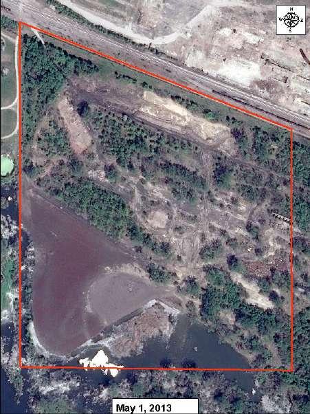
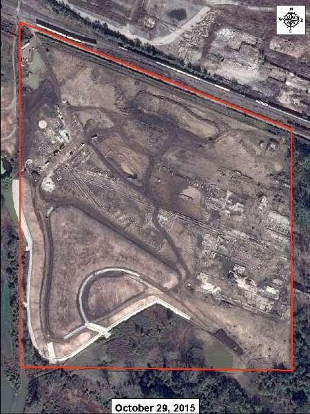
28 Former Lead Smelter 60 acre former lead smelter Former operations area on an upland plateau Smelter operated from 1900s to 1950s Operations generated 1.5 million tons of slag Metals-impacted soils, building debris, and former smoke stack debris RI completed 2012, remedial activities began in
29 Former Lead Smelter 60 acre former lead smelter Former operations area on an upland plateau Smelter operated from 1900s to 1950s Operations generated 1.5 million tons of slag Metals-impacted soils, building debris, and former smoke stack debris RI completed 2012, remedial activities began in 2013 Excavation Summary (cu yd = cubic yards) 12,000 cu yd excavated from the lowland 108,000 cu yd excavated from the upland EVS was used to calculate volume of soils in exceedance of multiple regulatory limits, design site excavations, and monitor volumes of excavated and placed material. 29
30 Former Lead Smelter The 2012 Remedial Investigation (RI) provided subsurface characterization data for EVS/MVS RI data supplemented with historical data Lead, Cadmium and Mercury risk-based drivers EVS 3D Kriging used to estimate volume of soil exceeding Lead OR Cadmium OR Mercury 2012 EVS estimate was 120,000 cu yd 2015 completion estimate 108,000 cu yd 30

31 31
32 Additional 3D Task Completed Volume estimates along a complex 3D slope (river bluff) Original alignment modified by material dumped from upland Identified native alignment with historical USGS Topos Supplemented with test pit excavations to native soil Input into EVS to calculate volume of non-native material, 8,500 cu yd 32
33 Additional 3D Task Completed Excavation and backfill design, soil volume updates in near real time 33
34 Additional 3D Task Completed Evaluation of USACE flood elevation surface 34


35 35


36 36
37 Chlorinated Solvent Site Applied HRSC and MIP Example 150 MIP + 35 collocated Direct Push confirmation soil borings Kriging results each day while deployed on-site. (i.e., Triad-based) Generates very large datasets - 96,000 records table for a 30ft bgs boring, 600+ records supplied as text files (CSV) base and data loading script created 37
38 Combined Boring Log Using gint and the MIP database At approximately 20% of MIP locations a collocated direct push (DP) soil boring was completed. Confirmation soil and groundwater samples collected based on MIP response. 38
39 Chlorinated Solvent Site Applied HRSC and MIP Example Identified a narrow neck of contamination pathway Estimates using a treatment volume delineated using only monitoring well results resulted in an treatment volume an order of magnitude greater High density data provided a more accurate representation of the plume and significant savings on the ISCO remedy Value of a quality model used to make smart decisions 39
40 Decision Support Tools Case Studies and Workflows Conclusion What are data based 3D/4D models and why are they useful? To clear the grey fog of subsurface uncertainty. The ability to visualize and critically evaluate complex 3 dimensional datasets improves clarity and decision confidence. When should they be used? Throughout the project lifecycle. What is required? of known quality. 40
41 QUESTIONS? CONTACT INFORMATION KERRY STONESTREET, P.G.
42 QUESTIONS? CONTACT INFORMATION KERRY STONESTREET, P.G.
43 Chlorinated Solvent Site MIP - Electrical Conductivity Model EC > 140 msm EC > 70 msm EC > 0 msm 43
44
DESIGN-PHASE GEOLOGIC FRAMEWORK MODELING FOR LARGE CONSTRUCTION PROJECTS
 DESIGN-PHASE GEOLOGIC FRAMEWORK MODELING FOR LARGE CONSTRUCTION PROJECTS Christine Vilardi, P.G., C.G.W.P. (vilardcl@stvinc.com, STV Inc., New York, New York) and Todd Kincaid, Ph.D. (Hazlett-Kincaid,
Application of SADA for 3D Subsurface Characterization and Suggested Approach for Volumetric Compliance with Decommissioning Dose Criteria
 Application of SADA for 3D Subsurface Characterization and Suggested Approach for Volumetric Compliance with Decommissioning Dose Criteria Robert Stewart, Ph.D. Oak Ridge National Laboratory University
SADA General Information
 SADA General Information Windows--based freeware designed to integrate scientific models with decision and cost analysis frameworks in a seamless, easy to use environment. Visualization/GIS Custom Analysis
Landslide Mapping and Hazard Analysis for a Natural Gas Pipeline Project
 CIVIL GOVERNMENT SERVICES MINING & METALS OIL, GAS & CHEMICALS POWER Albert Kottke, Mark Lee, & Matthew Waterman Landslide Mapping and Hazard Analysis for a Natural Gas Pipeline Project Technical Innovation
Optimization of Sediment Sampling at a Tidally Influenced Site (ArcGIS)
") Optimization of Sediment Sampling at a Tidally Influenced Site (ArcGIS) Contacts: Mark Malander, ExxonMobil Environmental Services Company, mark.w.malander@exxonmobil.com, Jeffrey A. Johnson, Newfields, Inc.,
Optimization of Sediment Sampling at a Tidally Influenced Site (ArcGIS) Contacts: Mark Malander, ExxonMobil Environmental Services Company, mark.w.malander@exxonmobil.com, Jeffrey A. Johnson, Newfields, Inc.,
Triad-Friendly Approaches to Data Collection Design
 Triad-Friendly Approaches to Data Collection Design Alternative Triad-Friendly Approaches Collaborative Data Sets Weight-of-evidence approaches Using lower analytical quality data for search, higher analytical
RITS Fall 2009 Getting the Most Out of Your Conceptual Site Model 1
 of Your Conceptual Site Model 1 of Your Conceptual Site Model 2 of Your Conceptual Site Model 3 of Your Conceptual Site Model 4 of Your Conceptual Site Model 5 The CSM is a comprehensive representation
Maximizing the Capital Efficiency of Contaminated Upstream Oil and Gas Sites Assessments by Using Geostatistical Modeling Approach
 Maximizing the Capital Efficiency of Contaminated Upstream Oil and Gas Sites Assessments by Using Geostatistical Modeling Approach Joseph Wells, Lian Zhao and Jarrett Leinweber Integrated Environments
TABLE 1 SSFL CHEMICAL SOIL BACKGROUND STUDY DATA QUALITY OBJECTIVES
 Problem Statement: Soil chemical concentration data for selected constituents are needed from off-site chemical background reference areas (CBRAs) to establish a regulatory-compliant, publicly-reviewed,
Technical Drafting, Geographic Information Systems and Computer- Based Cartography
 Technical Drafting, Geographic Information Systems and Computer- Based Cartography Project-Specific and Regional Resource Mapping Services Geographic Information Systems - Spatial Analysis Terrestrial
EPRI Report: Review of Geostatistical Approaches to Characterization of Subsurface Contamination
 EPRI Report: Review of Geostatistical Approaches to Characterization of Subsurface Contamination - 17442 Richard McGrath *, Richard Reid*, Phung Tran* *Electric Power Research Institute, 3420 Hillview
Bridging Subsurface Geologic Databases with Cross-Sections in GIS
 Bridging Subsurface Geologic Databases with Cross-Sections in GIS Eva E. von Thury ESRI International User Conference Padre Associates, Inc. Project Geologist / GIS Analyst June 29, 2016 Outline Introduction
National Atlas of Groundwater Dependent Ecosystems (GDE)
") National Atlas of Groundwater Dependent Ecosystems (GDE) Dr. Zaffar Sadiq Mohamed-Ghouse Executive Consultant & Practice Head-Spatial SKM, Australia zsadiq@globalskm.com Geospatial World Forum 2013, Rotterdam,
National Atlas of Groundwater Dependent Ecosystems (GDE) Dr. Zaffar Sadiq Mohamed-Ghouse Executive Consultant & Practice Head-Spatial SKM, Australia zsadiq@globalskm.com Geospatial World Forum 2013, Rotterdam,
Geological Models for Infrastructure Design:
 Geological Models for Infrastructure Design: Reducing Geotechnical Risk and Supporting Sustainability Alan Keith Turner Emeritus Professor of Geological Engineering CSM Visiting Research Associate - British
Table 5-1 Sampling Program Summary for Milltown Ford Avenue Redevelopment Area, NJ.
 Table 5- Sampling Program Summary for Milltown Ford Avenue Redevelopment Area, NJ. Transformer Pads (9 pads: PAD 9) Evaluate if PCBs presently exist in soils adjacent to, and/or beneath the transformer
Appendix I. Dredged Volume Estimates. Draft Contractor Document: Subject to Continuing Agency Review
 Appendix I Dredged Volume Estimates Draft Contractor Document: Subject to Continuing Agency Review Interoffice Correspondence Date: April 6, 2007 To: L. Bossi (WHI) Copy: S. Thompson (WHI), B. Fidler (NNJ)
Louisiana Transportation Engineering Conference. Monday, February 12, 2007
 Louisiana Transportation Engineering Conference Monday, February 12, 2007 Agenda Project Background Goal of EIS Why Use GIS? What is GIS? How used on this Project Other site selection tools I-69 Corridor
CHARACTERIZATION OF SOFT CLAY- A CASE STUDY AT CRANEY ISLAND
 National Defense Industrial Association 2005 Tri-Service Infrastructure Systems Conference and Exhibition Re-Energizing Engineering Excellence CHARACTERIZATION OF SOFT CLAY- A CASE STUDY AT CRANEY ISLAND
Extent of Radiological Contamination in Soil at Four Sites near the Fukushima Daiichi Power Plant, Japan (ArcGIS)
") Extent of Radiological Contamination in Soil at Four Sites near the Fukushima Daiichi Power Plant, Japan (ArcGIS) Contact: Ted Parks, AMEC Foster Wheeler, theodore.parks@amecfw.com, Alex Mikszewski, AMEC
Extent of Radiological Contamination in Soil at Four Sites near the Fukushima Daiichi Power Plant, Japan (ArcGIS) Contact: Ted Parks, AMEC Foster Wheeler, theodore.parks@amecfw.com, Alex Mikszewski, AMEC
Applied Geophysics for Environmental Site Characterization and Remediation
 Applied Geophysics for Environmental Site Characterization and Remediation MSECA Webinar September 24, 2015 John Mundell, P.E., L.P.G. Ryan Brumbaugh, L.P.G. MUNDELL & ASSOCIATES, INC. Webinar Objective
ENVS S102 Earth and Environment (Cross-listed as GEOG 102) ENVS S110 Introduction to ArcGIS (Cross-listed as GEOG 110)
 ENVS S110 Introduction to ArcGIS (Cross-listed as GEOG 110)") ENVS S102 Earth and Environment (Cross-listed as GEOG 102) 1. Describe the fundamental workings of the atmospheric, hydrospheric, lithospheric, and oceanic systems of Earth 2. Explain the interactions
ENVS S102 Earth and Environment (Cross-listed as GEOG 102) 1. Describe the fundamental workings of the atmospheric, hydrospheric, lithospheric, and oceanic systems of Earth 2. Explain the interactions
Back-to-Basics Part 1: Developing the CSM & Site Characterization
 Back-to-Basics Part 1: Developing the CSM & Site Characterization Agenda What is a CSM and how do you use it Physical Components (Geology, Hydrogeology, and Chemistry) Site Use History Likely Fate and
GIS Applications in Groundwater Protection /Term Paper Final Paper
 GIS Applications in Groundwater Protection /Term Paper Final Paper By Humoud W. Al-Utaibi ID #937501 For CRP 514: Introduction to GIS Term 061 13 th Offer Course Instructor: Dr. Baqer Al-Ramadan Date:
Permeable Treatment Wall Project
 West Valley Demonstration Project West Valley Environmental Services Permeable Treatment Wall Project 20614_1 John Chamberlain May 26, 2010 West Valley Citizen Task Force Meeting West Valley Demonstration
Role of the Geotechnical Consultant in Design Build Projects a General Contractors Geotechnical Engineer s Perspective
 Role of the Geotechnical Consultant in Design Build Projects a General Contractors Geotechnical Engineer s Perspective Steven R. Saye Kiewit Engineering Group, Inc. Design Build Geotechnical Goal All parties
Enabling Success in Enterprise Asset Management: Case Study for Developing and Integrating GIS with CMMS for a Large WWTP
 Enabling Success in Enterprise Asset Management: Case Study for Developing and Integrating GIS with CMMS for a Large WWTP Allison Blake, P.E. 1*, Matthew Jalbert, P.E. 2, Julia J. Hunt, P.E. 2, Mazen Kawasmi,
Coordinate systems, measured surveys for BIM, total station for BIM, as-built surveys, setting-out
 Coordinate systems, measured surveys for BIM, total station for BIM, as-built surveys, setting-out What is a BIM What does a BIM do Why use a BIM BIM Software BIM and the Surveyor How do they relate to
Minimum Standards for Wetland Delineations
 Minimum Standards for Wetland Delineations Jason Gipson Chief, Utah/Nevada Regulatory Branch Sacramento District Regulatory Program Workshop 16 Mar 2016 US Army Corps of Engineers Delineation Report Minimum
Geophysical Exploration in Water Resources Assessment. John Mundell, P.E., L.P.G., P.G. Ryan Brumbaugh, L.P.G. Mundell & Associates, Inc.
 Geophysical Exploration in Water Resources Assessment John Mundell, P.E., L.P.G., P.G. Ryan Brumbaugh, L.P.G. Mundell & Associates, Inc. Presentation Objective Introduce the use of geophysical survey methods
GEOMATICS. Shaping our world. A company of
 GEOMATICS Shaping our world A company of OUR EXPERTISE Geomatics Geomatics plays a mayor role in hydropower, land and water resources, urban development, transport & mobility, renewable energy, and infrastructure
SAN FRANCISCO DISTRICT INFORMATION REQUESTED FOR VERIFICATION OF CORPS JURISDICTION
 DEPARTMENT OF THE ARMY SAN FRANCISCO DISTRICT, U.S. ARMY CORPS OF ENGINEERS 1455 MARKET STREET SAN FRANCISCO, CALIFORNIA 94103-1398 SAN FRANCISCO DISTRICT INFORMATION REQUESTED FOR VERIFICATION OF CORPS
Dealing with Zone A Flood Zones. Topics of Discussion. What is a Zone A Floodplain?
 Dealing with Zone A Flood Zones Topics of Discussion Overview of Zone A Floodplains Permitting Development in Zone A Floodplains Estimating Flood Elevations in Zone A Flood Insurance Implications Letters
An Integrated Fire, Smoke and Air Quality Data & Tools Network
 An Integrated Fire, Smoke and Air Quality Data & Tools Network Stefan Falke and Rudolf Husar Center for Air Pollution Impact and Trend Analysis Washington University in St. Louis Brooke Hemming US EPA
pcf REQUIRED: Determine the shear strength parameters for use in a preliminary shallow foundation design. SOLUTION:
 14.330 SOIL MECHANICS Assignment #8: Shear Strength Solution. PROBLEM #1: GIVEN: A regional residential building contractor is planning on building a custom 4,100 ft² home on Martha s Vineyard, MA. The
FRACTURED ROCK Characterization and Remediation. Allan Horneman September 30, 2016
 FRACTURED ROCK Characterization and Remediation Allan Horneman September 30, 2016 Disclaimers and Notices The materials herein are intended to furnish viewers with a summary and overview of general information
Our Services. What We Do. How We Can Help. Contact us today: January (0)
") Listening and Understanding to Optimize our Efficiency Our Experience and Knowledge to Work for You Tailor-made Solutions to Meet your Needs Our Challenge is You Success What We Do Our Services GeoViz
Listening and Understanding to Optimize our Efficiency Our Experience and Knowledge to Work for You Tailor-made Solutions to Meet your Needs Our Challenge is You Success What We Do Our Services GeoViz
Geospatial natural disaster management
 Geospatial natural disaster management disasters happen. are you ready? Natural disasters can strike almost anywhere at any time, with no regard to a municipality s financial resources. These extraordinarily
Overview. Project Background Project Approach: Content and Application Development Application Demonstration Future Developments
 Overview Project Background Project Approach: Content and Application Development Application Demonstration Future Developments Southeast Pressures: Continued Population Growth Transportation Corridors
Remedial Program. GE Hudson Falls Plant Site. GE Hudson Falls Plant Site. TDCS Status
 Updates on Remedial Programs at the GE Hudson Falls Plant Site and GE Fort Edward Plant Site GE Hudson Falls USEPA Community Advisory Group Meeting September 11, 2008 GE Fort Edward Division of Environmental
Tools for building and delivering 3D models Perspectives by the BGS
 Tools for building and delivering 3D models Perspectives by the BGS Holger Kessler (on behalf of the 3D community of BGS) Kingsley Dunham Centre Keyworth Nottingham NG12 5GG Tel 0115 936 3100 www.bgs.ac.uk/3dg
1 Complementary Access Tools
 ENERGY IHS AccuMap Shaped by industry and powered by IHS Markit information, AccuMap is a powerful and intuitive interpretation solution for the Canadian Energy Industry. 1 Complementary Access Tools AccuLogs
NR402 GIS Applications in Natural Resources
 NR402 GIS Applications in Natural Resources Lesson 1 Introduction to GIS Eva Strand, University of Idaho Map of the Pacific Northwest from http://www.or.blm.gov/gis/ Welcome to NR402 GIS Applications in
URANIUM RESEARCH ON NATIVE LANDS
 URANIUM RESEARCH ON NATIVE LANDS NSF HIGHLIGHTS TRACK 1 RESEARCH TITLE Uranium Transport and Site Remediation research crosses cultural borders to protect people and the environment OUTCOME Scientists
WM2011 Conference, February 27 - March 3, 2011, Phoenix, AZ
 Methodology for Determination of Exposure Point Concentration Using both Systematic and Biased Samples for Radiological Risk and Dose Assessments 11488 Randy Hansen*, Michael Steven Passig*, Mahmudur Rahman**
DEPARTMENT OF GEOLOGY AND MINERAL INDUSTRIES WAYS & MEANS SUBCOMMITTEE ON NATURAL RESOURCES MARCH 2, 2017
 DEPARTMENT OF GEOLOGY AND MINERAL INDUSTRIES WAYS & MEANS SUBCOMMITTEE ON NATURAL RESOURCES MARCH 2, 2017 1 ABOUT DOGAMI AGENCY MISSION, VISION & GOALS 2 Lidar image of a stream network along the Umpqua
Utah UIC Geospatial Integration EIEN Project
 Utah UIC Geospatial Integration EIEN Project ESRI UC, June 2007 Bert Granberg Utah Automated Geographic Reference Center Utah Automated Geographic Reference Center (AGRC) AGRC Responsibilities Facilitate
AUCKLAND MOTORWAY EXTENSION NORTHLAND REGION, NEW ZEALAND
 LEAPFROG WORKS 1 CASE STUDY Case Study: Tonkin & Taylor and Beca Design JV Puhoi to Warkworth motorway AUCKLAND MOTORWAY EXTENSION NORTHLAND REGION, NEW ZEALAND 2 The 3D subsurface model encompasses the
IN SITU CHEMICAL OXIDATION SHORT COURSE DESCRIPTION, OUTLINE, AND BIOS Presented by Will Caldicott of In Situ Oxidative Technologies, Inc.
 IN SITU CHEMICAL OXIDATION SHORT COURSE DESCRIPTION, OUTLINE, AND BIOS Presented by Will Caldicott of In Situ Oxidative Technologies, Inc. In-situ oxidation techniques have been utilized by the North American
Features and Benefits
 Autodesk LandXplorer Features and Benefits Use the Autodesk LandXplorer software family to help improve decision making, lower costs, view and share changes, and avoid the expense of creating physical
Chesapeake Bay Remote Sensing Pilot Executive Briefing
 Chesapeake Bay Remote Sensing Pilot Executive Briefing Introduction In his Executive Order 13506 in May 2009, President Obama stated The Chesapeake Bay is a national treasure constituting the largest estuary
Spatial Data Approaches to Improve Production and Reduce Risks of Impacts
 Spatial Data Approaches to Improve Production and Reduce Risks of Impacts Geospatial & Geostatistical Analyses to Improve Science-Based Decision Making Kelly Rose, Geology & Geospatial Research Lead Jennifer
FIRE DEPARMENT SANTA CLARA COUNTY
 DEFINITION FIRE DEPARMENT SANTA CLARA COUNTY GEOGRAPHIC INFORMATION SYSTEM (GIS) ANALYST Under the direction of the Information Technology Officer, the GIS Analyst provides geo-spatial strategic planning,
A method for three-dimensional mapping, merging geologic interpretation, and GIS computation
 A method for three-dimensional mapping, merging geologic interpretation, and GIS computation Soller, David R., U.S. Geological Survey, 908 National Center, Reston, VA 20192 and Richard C. Berg, Illinois
NEW PRODUCTS AND ADVANCEMENTS IN 3-D MODELLING PROTOCOLS BASED ON STUDIES IN THICK DRIFT AREAS IN ONTARIO, CANADA
 NEW PRODUCTS AND ADVANCEMENTS IN 3-D MODELLING PROTOCOLS BASED ON STUDIES IN THICK DRIFT AREAS IN ONTARIO, CANADA Abigail K. Burt and Andrew F. Bajc Ontario Geological Survey, 933 Ramsey Lake Road, Sudbury,
Dam Removal Analysis Guidelines for Sediment
 A review of: Dam Removal Analysis Guidelines for Sediment Joe Rathbun (Retired) rathbunj@sbcglobal.net Some Potential Sediment Issues Reservoir restoration Downstream water quality Downstream deposition
INCREMENTAL SAMPLING METHODOLOGY
 INCREMENTAL SAMPLING METHODOLOGY 1. INTRODUCTION Incremental sampling methodology (ISM) is a structured composite sampling and processing protocol having specific elements designed to reduce data variability
Programmatic Approaches to Assessing and Mitigating Risk to Pipelines from Natural Forces
 Programmatic Approaches to Assessing and Mitigating Risk to Pipelines from Natural Forces 23 rd International Petroleum Environmental Conference New Orleans, Louisiana November 8-10, 2016 Introduction
A Help Guide for Using gssurgo to Find Potential Wetland Soil Landscapes
 A Help Guide for Using gssurgo to Find Potential Wetland Soil Landscapes Wetland Mapping Consortium Webinar September 17, 2014 Dr. John M. Galbraith Crop & Soil Environmental Sciences Virginia Tech Wetland
Bedrock Characterization Mottolo Pig Farm Superfund Site
 Bedrock Characterization Mottolo Pig Farm Superfund Site Andrew Drew Hoffman, PE NH Department of Environmental Services andrew.hoffman@des.nh.gov 603.271.6778 1 Acknowledgments GZA GeoEnvironmental (lead
STEREO ANALYST FOR ERDAS IMAGINE Stereo Feature Collection for the GIS Professional
 STEREO ANALYST FOR ERDAS IMAGINE Stereo Feature Collection for the GIS Professional STEREO ANALYST FOR ERDAS IMAGINE Has Your GIS Gone Flat? Hexagon Geospatial takes three-dimensional geographic imaging
BOS 100 Overburden and Bedrock Groundwater Remediation Former Dry Cleaning Facility
 BOS 100 Overburden and Bedrock Groundwater Remediation Former Dry Cleaning Facility Site Description Location Central Kentucky Site Use Retail Shopping Center Geologic Setting Inner Bluegrass Bedrock Ordovician
USGS National Geospatial Program Understanding User Needs. Dick Vraga National Map Liaison for Federal Agencies July 2015
 + USGS National Geospatial Program Understanding User Needs Dick Vraga National Map Liaison for Federal Agencies July 2015 + Topics 2 Background Communities of Use User Surveys National Map Liaisons Partnerships
Document Title. Estimating the Value of Partner Contributions to Flood Mapping Projects. Blue Book
 Document Title Estimating the Value of Partner Contributions to Flood Mapping Projects Blue Book Version 1.1 November 2006 Table of Contents 1. Background...1 2. Purpose...1 3. Overview of Approach...2
4. GIS Implementation of the TxDOT Hydrology Extensions
 4. GIS Implementation of the TxDOT Hydrology Extensions A Geographic Information System (GIS) is a computer-assisted system for the capture, storage, retrieval, analysis and display of spatial data. It
Desktop GIS for Geotechnical Engineering
 Desktop GIS for Geotechnical Engineering Satya Priya Deputy General Manager (Software) RMSI, A-7, Sector 16 NOIDA 201 301, UP, INDIA Tel: +91-120-2511102 Fax: +91-120-2510963 Email: Satya.Priya@rmsi.com
Manitoba s Elevation (LiDAR) & Imagery Datasets. Acquisition Plans & Opportunities for Collaboration
 & Imagery Datasets. Acquisition Plans & Opportunities for Collaboration") Manitoba s Elevation (LiDAR) & Imagery Datasets Acquisition Plans & Opportunities for Collaboration Manitoba Planning Conference May 2017 Presentation Outline Manitoba s Elevation (LiDAR) and Imagery Datasets
Manitoba s Elevation (LiDAR) & Imagery Datasets Acquisition Plans & Opportunities for Collaboration Manitoba Planning Conference May 2017 Presentation Outline Manitoba s Elevation (LiDAR) and Imagery Datasets
Summary Description Municipality of Anchorage. Anchorage Coastal Resource Atlas Project
 Summary Description Municipality of Anchorage Anchorage Coastal Resource Atlas Project By: Thede Tobish, MOA Planner; and Charlie Barnwell, MOA GIS Manager Introduction Local governments often struggle
Chapter 6. Fundamentals of GIS-Based Data Analysis for Decision Support. Table 6.1. Spatial Data Transformations by Geospatial Data Types
 Chapter 6 Fundamentals of GIS-Based Data Analysis for Decision Support FROM: Points Lines Polygons Fields Table 6.1. Spatial Data Transformations by Geospatial Data Types TO: Points Lines Polygons Fields
Guidelines for Site-Specific Seismic Hazard Reports for Essential and Hazardous Facilities and Major and Special-Occupancy Structures in Oregon
 Guidelines for Site-Specific Seismic Hazard Reports for Essential and Hazardous Facilities and Major and Special-Occupancy Structures in Oregon By the Oregon Board of Geologist Examiners and the Oregon
Development of a national geophysical log data archive: legacy data as a national asset
 Development of a national geophysical log data archive: legacy data as a national asset Andrew Kingdon & Mark Fellgett Contributions by Helen Bonsor & Diarmad Campbell aki@bgs.ac.uk 0115 936 3415 Preserving
CREATING USACE SPATIAL DATA STANDARDS-COMPLIANT GEODATABASES FOR STORAGE AND RETRIEVAL OF SPATIALLY REFERENCED DREDGE MATERIAL ANALYTICAL RESULTS
 CREATING USACE SPATIAL DATA STANDARDS-COMPLIANT GEODATABASES FOR STORAGE AND RETRIEVAL OF SPATIALLY REFERENCED DREDGE MATERIAL ANALYTICAL RESULTS Christine Smith 1, Nadia Lombardero 2, and Philip M. Wolf
EnviroAtlas: An Atlas about Ecosystems and their Connection with People
 EnviroAtlas: An Atlas about Ecosystems and their Connection with People Annie Neale, Megan Mehaffey & Atlas Team ASWM Webinar October, 17 th, 2012 What is it? The Atlas is an online decision support tool
GIS for Integrated Pest Management. Christina Hailey. Abstract:
 GIS for Integrated Pest Management Christina Hailey Abstract: At its formation in 1965, Harris County Mosquito Control (Houston, Texas) (HCMC) was primarily involved in the prevention and control of mosquito-borne
Aquitard Characterization The Legend of Indiana s Magic Clay Layer. Juliet Port, LPG #2214 July 2014
 Aquitard Characterization The Legend of Indiana s Magic Clay Layer Juliet Port, LPG #2214 July 2014 Topics What is an Aquitard? Why do we care? Review of Indiana glacial geology Conceptual Framework Investigation
U.S. Geological Survey Agency Briefing for MAPPS Mark L. DeMulder Director, National Geospatial Program. March 12, 2013
 + U.S. Geological Survey Agency Briefing for MAPPS Mark L. DeMulder Director, National Geospatial Program March 12, 2013 + 3D Elevation Program (3DEP) National Leadership The National Enhanced Elevation
FROM 2D CROSS-SECTIONS TO A 3D MODEL: A TOOLSET FOR INTEGRATED DATA MANAGEMENT, MODELING, AND VISUALIZATION
 63 FROM 2D CROSS-SECTIONS TO A 3D MODEL: A TOOLSET FOR INTEGRATED DATA MANAGEMENT, MODELING, AND VISUALIZATION Nat Voorhies 1, Scott Bowen 2, Tom Battenhouse 3, Rob Porges 3, and Tad Fox 3 1 SAIC, Oakland,
Simplified GIS Requirements: New Data Models and Standards for Future WWDC Projects November 15 th, 2017 Technical Training
 Simplified GIS Requirements: New Data Models and Standards for Future WWDC Projects November 15 th, 2017 Technical Training Agenda Project Introduction Data Model and Metadata Framework Plan and Technical
Imagery and the Location-enabled Platform in State and Local Government
 Imagery and the Location-enabled Platform in State and Local Government Fred Limp, Director, CAST Jim Farley, Vice President, Leica Geosystems Oracle Spatial Users Group Denver, March 10, 2005 TM TM Discussion
Appendix G. Summary of Hydrogeologic Conditions and Historical Mining Northwest of the Centro Subarea in the Randsburg, Red Mountain, and Atolia Area
 Appendix G Summary of Hydrogeologic Conditions and Historical Mining Northwest of the Centro Subarea in the Randsburg, Red Mountain, and Atolia Area 1.1 Background This appendix provides a summary of hydrogeologic
1.1 What is Site Fingerprinting?
 Site Fingerprinting Utilizing GIS/GPS Technology 1.1 What is Site Fingerprinting? Site fingerprinting is a planning tool used to design communities where protection of natural resources is the primary
TRAITS to put you on the map
 TRAITS to put you on the map Know what s where See the big picture Connect the dots Get it right Use where to say WOW Look around Spread the word Make it yours Finding your way Location is associated with
THE ROLE OF 3-D GEOLOGIC MODELING AND DATABASE SOLUTIONS IN THE VIRTTAANKANGAS ARTIFICIAL RECHARGE PROJECT, SOUTHWESTERN FINLAND
 THE ROLE OF 3-D GEOLOGIC MODELING AND DATABASE SOLUTIONS IN THE VIRTTAANKANGAS ARTIFICIAL RECHARGE PROJECT, SOUTHWESTERN FINLAND Artimo, A. 1, S. Saraperä 2, and I. Ylander 1 1 Turku Region Water Ltd.,
DGS Digital Geologic Information Resource (DGIR) User Guide
 User Guide") DGS Digital Geologic Information Resource (DGIR) User Guide Developed by the Delaware Geological Survey. Revised January 2012. TABLE OF CONTENTS I. INTRODUCTION II. DGIR LAYOUT III. TOOLBARS IV. USING
DGS Digital Geologic Information Resource (DGIR) User Guide Developed by the Delaware Geological Survey. Revised January 2012. TABLE OF CONTENTS I. INTRODUCTION II. DGIR LAYOUT III. TOOLBARS IV. USING
Automated Identification and Characterization of Landforms on Mars
 Automated Identification and Characterization of Landforms on Mars Tomasz F. Stepinski Lunar and Planetary Institute Collaborators: Wei Luo Students: Brain Bue Ian Molloy Erik Urbach Michael Mendenhall
Groundwater Modeling for Flow Systems with Complex Geological and Hydrogeological Conditions
 Available online at www.sciencedirect.com Procedia Earth and Planetary Science 3 ( 2011 ) 23 28 2011 Xi an International Conference on Fine Geological Exploration and Groundwater & Gas Hazards Control
GIS = Geographic Information Systems;
 What is GIS GIS = Geographic Information Systems; What Information are we talking about? Information about anything that has a place (e.g. locations of features, address of people) on Earth s surface,
USGS Hydrography Overview. May 9, 2018
 + 1 USGS Hydrography Overview May 9, 2018 + 2 The National Geospatial Program Provides the geospatial baseline of the Nation s topography, natural landscape and built environment through The National Map,
Assessing Groundwater Vulnerability and Contaminant Pathways at MCAS Beaufort, SC
 Assessing Groundwater Vulnerability and Contaminant Pathways at MCAS Beaufort, SC James M. Rine, John M. Shafer, Elzbieta Covington Abstract A project to assess the vulnerability of groundwater resources
Estimating Remedial Volumes for a GLLA Project on the Milwaukee River
 Estimating Remedial Volumes for a GLLA Project on the Milwaukee River Mike Ciarlo, Jamie Beaver, Mike Powell, Jason Byler EA Engineering, Science, and Technology, Inc. Marsha Burzynski, William Fitzpatrick
Land Administration and Cadastre
 Geomatics play a major role in hydropower, land and water resources and other infrastructure projects. Lahmeyer International s (LI) worldwide projects require a wide range of approaches to the integration
Key Considerations for Ensuring Quality Radioanalytical Laboratory Services for Superfund Sites Activities
 Key Considerations for Ensuring Quality Radioanalytical Laboratory Services for Superfund Sites Activities John Griggs, Director Center for Radioanalytical Laboratory Science (CERLS) National Air and Radiation
FORENSIC GEOLOGY A CIVIL ACTION
 NAME 89.215 - FORENSIC GEOLOGY A CIVIL ACTION I. Introduction In 1982 a lawsuit was filed on behalf of eight Woburn families by Jan Schlictmann. The suit alleged that serious health effects (childhood
Press kit Kartotrak 2014 June 2nd, 2014
 Press kit Kartotrak 2014 June 2nd, 2014 Worldwide leader in Geostatistics, Geovariances enables its clients involved with mapping, resource estimation or risk analysis to benefit from more than 25 years
Environmental Sequence Stratigraphy: A Focus on Geology for Improved Remediation Decision Making
 Environmental Sequence Stratigraphy: A Focus on Geology for Improved Remediation Decision Making Rick Cramer, PG (Burns and McDonnell); Mike Shultz (AECOM); Colin Plank (AECOM); Herb Levine (US EPA, Region
Web-enabled GIS Services
 Austin Davis Research Geographer US Army Engineer Research and Development Center, Environmental Laboratory (EL) Waterways Experiment Station (WES), Vicksburg, Mississippi Environmental Systems Branch
IRTC Incremental Sampling Methodology February 2012
 7. MAKING DECISIONS USING ISM DATA 7.1 Introduction This section provides guidance on using data generated from ISM samples to make decisions about a DU. Since the data may inform one or more decisions;
Blog. Infraworks 360 Model Creation Process. by David Crowther
 Page 1 of 6 Infraworks 360 Model Creation Process by David Crowther Cadline has a team of geospatial specialists with expertise in the integration of both CAD and GIS applications, and so were asked to
GIS for integrated 2D H&H modeling support. Dean Djokic and Lori Armstrong, Esri Inc.
 GIS for integrated 2D H&H modeling support Dean Djokic and Lori Armstrong, Esri Inc. Overview GIS for H&H modeling support 1D vs. 2D modeling with GIS GIS techniques for data simplification Schematization
NAVAJO NATION PROFILE
 NAVAJO NATION PROFILE Largest land based area and federally recognized tribe in the United States Over 27,000 square miles (or 17.2 million acres with a population of over 300,000 people. Covers Arizona,
Roger Andy Gaines, Research Civil Engineer, PhD, P.E.
 Roger Andy Gaines, Research Civil Engineer, PhD, P.E. Research Civil Engineer/Regional Technical Specialist Memphis District August 24, 2010 Objectives Where we have been (recap of situation and what s