Maximizing the Capital Efficiency of Contaminated Upstream Oil and Gas Sites Assessments by Using Geostatistical Modeling Approach
|
|
|
- Egbert Blake Lester
- 5 years ago
- Views:
Transcription
 Ltd.")
1 Maximizing the Capital Efficiency of Contaminated Upstream Oil and Gas Sites Assessments by Using Geostatistical Modeling Approach Joseph Wells, Lian Zhao and Jarrett Leinweber Integrated Environments (2006) Ltd. Submitted to: the RemTech 2012 the Environmental Services Association of Alberta (ESAA) Fairmont Banff Springs, Alberta October 17-19, 2012
2 Contaminated Site Liability Management Processes Real time decisionmaking Strategic Planning Next step switches from Lab analysis uncertainty to decision uncertainty based on the geostatistical prediction Stringent regulatory compliance Dynamic monitoring

3 Cited: Argonne National Laboratory, 2003


4 Site Conceptual Model Base Map Site Geological Information Sampling Data Quantitative Contaminant extent Sampling and prediction
5 Life-cycle Cost Curve of Remediation
6 Introduction to Geostatistics Developed in the 1960s, by the South African mining engineer Danie G. Krige (1919). Principle: spatial and temporary autocorrelation, interpolating the unsampled locations. Purpose: Generally: spatial pattern, spatial interpolation and modeling if local and spatial uncertainty exist. For contaminated site investigations: visualize and analyze the monitoring data, predicted the unsampled locations and delineate the boundary of impacted environmental media for further remediation.
7

8 Regionalized Variables and Kridging Regionalized Variables The attributes of contaminated sites are regionalized variables, not deterministic or random. Kriging - An interpolation technique The surrounding measured values are weighted to derive a predicted value for an unmeasured location. Weights are based on the distance between the measured points, the prediction locations and the overall spatial arrangement among the measured points.
9 Application in Environmental Modeling Regional air monitoring modeling Soil and groundwater site investigation results and contamination plume remediation and predictions Soil site characterizations Optimizations of remediation parameters
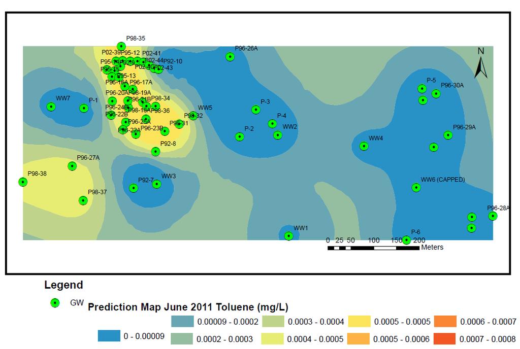
10 ESRI ArcGIS Geostatistical Analyst A suite of statistical models and tools for spatial data exploration and surface generation create statistically valid prediction surface, along with prediction uncertainties, from a limited number of data measurements. Outcomes: Threshold mapping: Probability mapping can be generated to predict the area to exceed the threshold. Prediction mapping Quantile
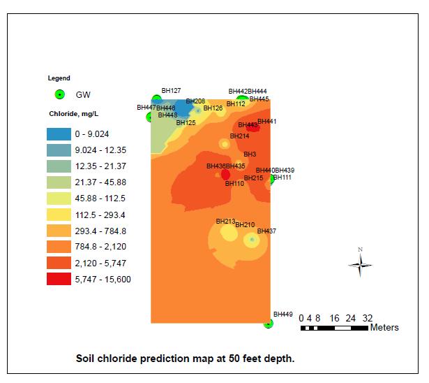
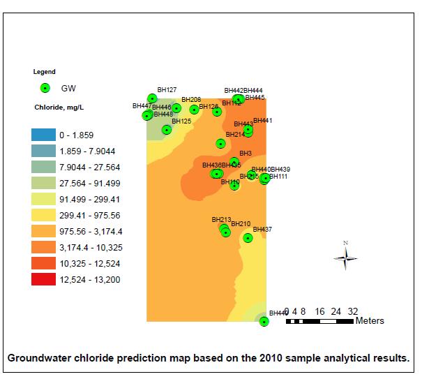
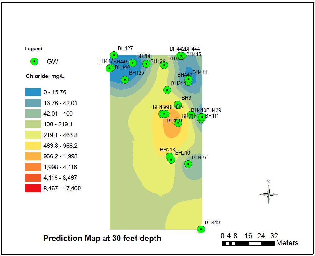
11 Case studies Impacted soil volume estimation for flare pit sites Groundwater contamination mapping for a gas plant
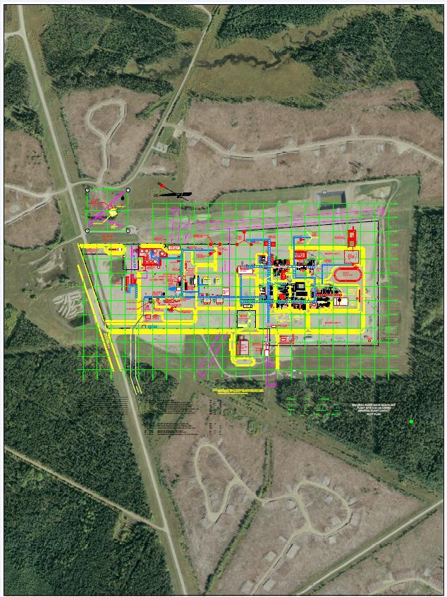
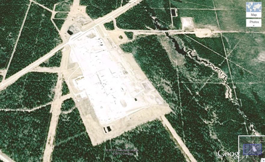
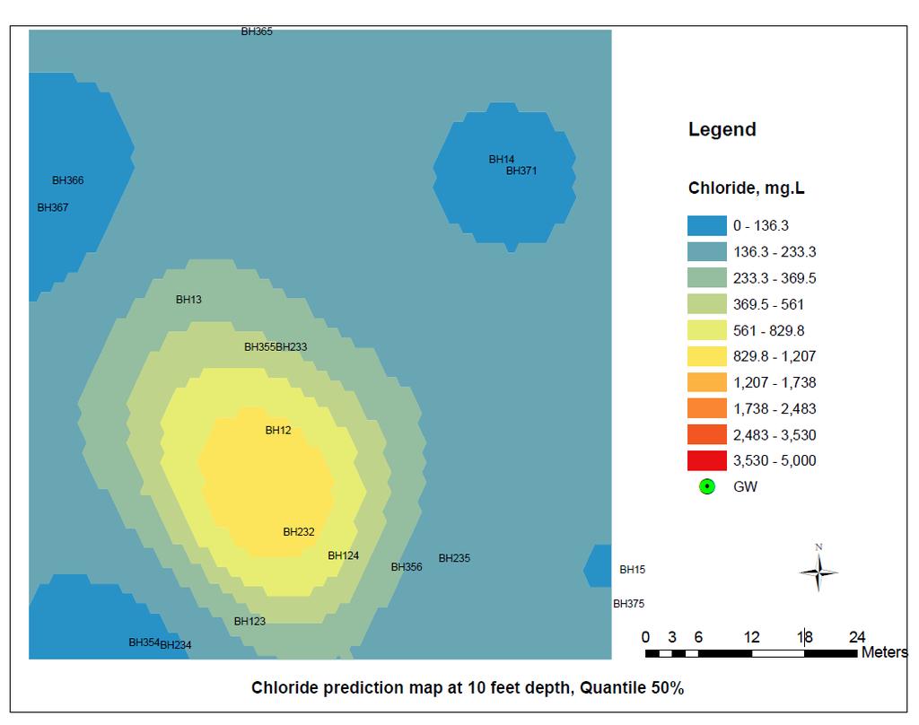
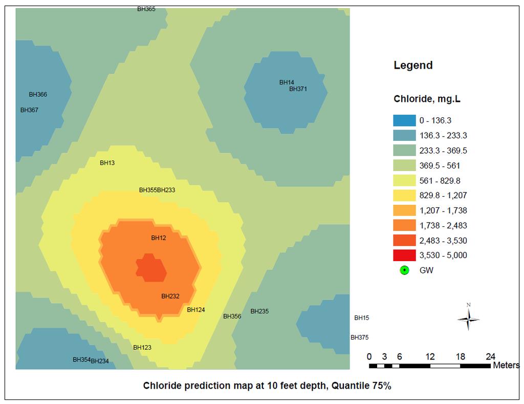
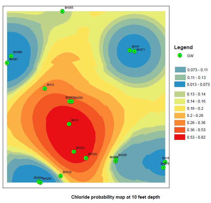
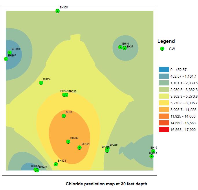
12 Groundwater Monitoring for A Gas Plant

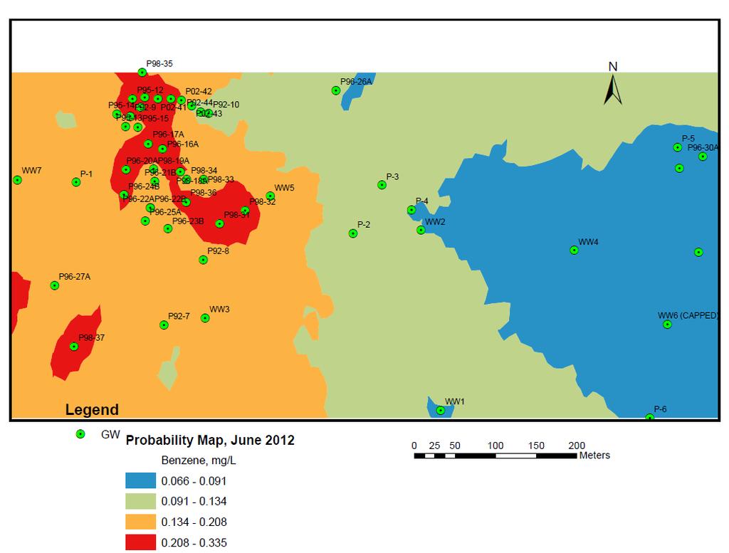
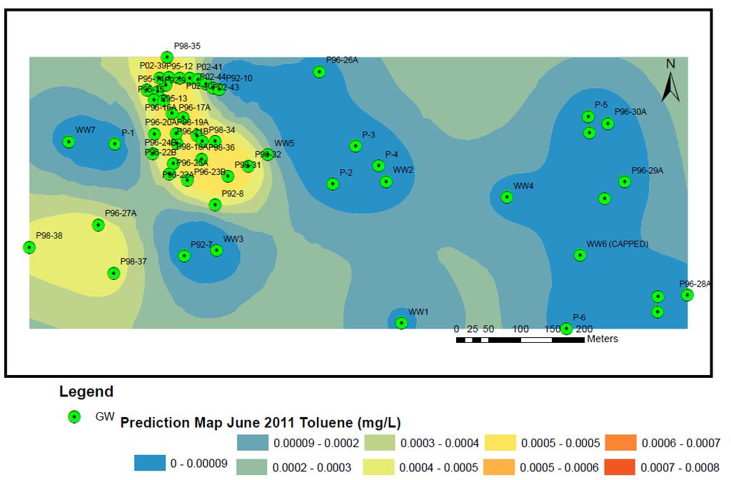
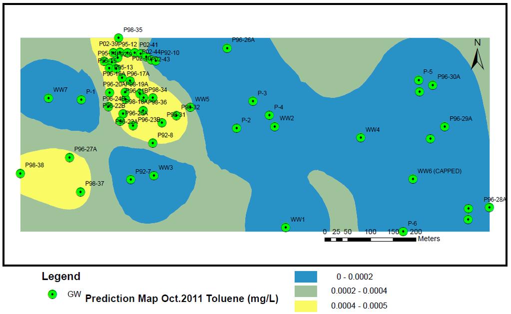
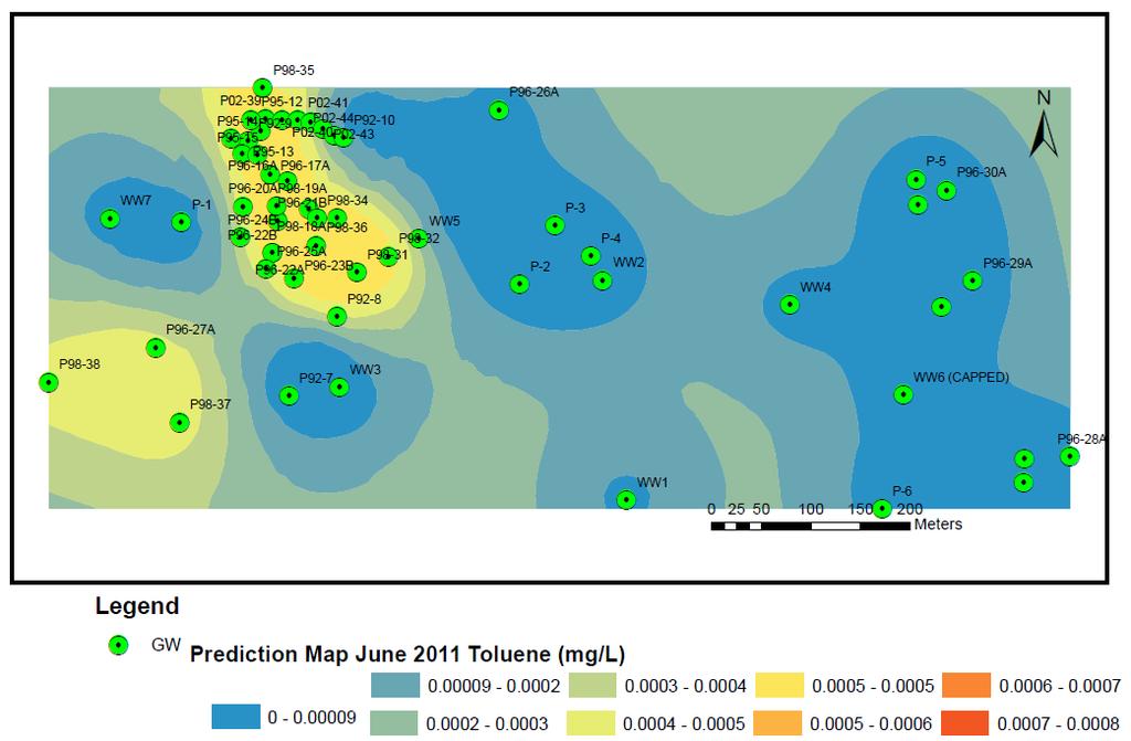
13 Benzene in groundwater June 2012
14
15
16
17
18
19
20
21 Site 780
22
23
24

25
26
27
28
29 Estimate the volume of impacted soil Geometric estimation of the potentially contaminated layer via 2D kriging to determine the distribution of contaminants at certain depth of contaminated sites. Calculated the volume of impacted soil.
30 Estimated Volume of impacted soil amount Comparison of estimated contaminated soil volume by conventional and geostatistical method (m 3 ) Geostatistcal Method Conventional method Flare pit 1 (786) Flare pit 2 (15256) Flare pit 3 (10295)
31 Conclusions Geostatistics provide a relevant prediction of the contaminated volumes and uncertainty if remediation constraints are taken into account 1. Real integration of geostatistics in the remediation workflow 2. Geostatistical approach outcomes: Data quality control Relevant estimates Coupled with uncertainty quantification, or both contaminated and excavated volumes. Cost / benefit analysis via progress of site investigations proceed 3. Such results are useful to optimize the planning of the excavation phase and better assess its related costs.
 Ltd. 403.685.")
32 Thank you! Questions? Contact Lian Zhao, PhD, P. Eng. Senior Environmental Specialist and Engineer Integrated Environments (2006) Ltd (Main)
Isatis applications for soil pollution mapping and risk assessment
 Isatis applications for soil pollution mapping and risk assessment Nicolas JEANNEE Contact: Email: jeannee@geovariances.fr - Tel: +33 ()4.67.6.61.96 ISATIS User s Meeting Fontainebleau, Sept. 26 Objective
Extent of Radiological Contamination in Soil at Four Sites near the Fukushima Daiichi Power Plant, Japan (ArcGIS)
") Extent of Radiological Contamination in Soil at Four Sites near the Fukushima Daiichi Power Plant, Japan (ArcGIS) Contact: Ted Parks, AMEC Foster Wheeler, theodore.parks@amecfw.com, Alex Mikszewski, AMEC
Extent of Radiological Contamination in Soil at Four Sites near the Fukushima Daiichi Power Plant, Japan (ArcGIS) Contact: Ted Parks, AMEC Foster Wheeler, theodore.parks@amecfw.com, Alex Mikszewski, AMEC
11/8/2018. Spatial Interpolation & Geostatistics. Kriging Step 1
 (Z i Z j ) 2 / 2 (Z i Zj) 2 / 2 Semivariance y 11/8/2018 Spatial Interpolation & Geostatistics Kriging Step 1 Describe spatial variation with Semivariogram Lag Distance between pairs of points Lag Mean
It s a Model. Quantifying uncertainty in elevation models using kriging
 It s a Model Quantifying uncertainty in elevation models using kriging By Konstantin Krivoruchko and Kevin Butler, Esri Raster based digital elevation models (DEM) are the basis of some of the most important
Lecture 8. Spatial Estimation
 Lecture 8 Spatial Estimation Lecture Outline Spatial Estimation Spatial Interpolation Spatial Prediction Sampling Spatial Interpolation Methods Spatial Prediction Methods Interpolating Raster Surfaces
PRODUCING PROBABILITY MAPS TO ASSESS RISK OF EXCEEDING CRITICAL THRESHOLD VALUE OF SOIL EC USING GEOSTATISTICAL APPROACH
 PRODUCING PROBABILITY MAPS TO ASSESS RISK OF EXCEEDING CRITICAL THRESHOLD VALUE OF SOIL EC USING GEOSTATISTICAL APPROACH SURESH TRIPATHI Geostatistical Society of India Assumptions and Geostatistical Variogram
Spatial Interpolation & Geostatistics
 (Z i Z j ) 2 / 2 Spatial Interpolation & Geostatistics Lag Lag Mean Distance between pairs of points 1 y Kriging Step 1 Describe spatial variation with Semivariogram (Z i Z j ) 2 / 2 Point cloud Map 3
Assessing the Tier 2 Trigger for Fractured Sedimentary Bedrock Sites
 Assessing the Tier 2 Trigger for Fractured Sedimentary Bedrock Sites Ken Lyon, Jennifer Arnold, Louise Burden Advisian WorleyParsons Group RemTech 2015, October 16, Banff, AB INTRODUCTION High level look
Lecture 5 Geostatistics
 Lecture 5 Geostatistics Lecture Outline Spatial Estimation Spatial Interpolation Spatial Prediction Sampling Spatial Interpolation Methods Spatial Prediction Methods Interpolating Raster Surfaces with
ArcGIS Geostatistical Analyst: Powerful Exploration and Data Interpolation Solutions
 TM ArcGIS Geostatistical Analyst: Powerful Exploration and Data Interpolation Solutions An ESRI White Paper March 2001 ESRI 380 New York St., Redlands, CA 92373-8100, USA TEL 909-793-2853 FAX 909-793-5953
Application of SADA for 3D Subsurface Characterization and Suggested Approach for Volumetric Compliance with Decommissioning Dose Criteria
 Application of SADA for 3D Subsurface Characterization and Suggested Approach for Volumetric Compliance with Decommissioning Dose Criteria Robert Stewart, Ph.D. Oak Ridge National Laboratory University
ArcGIS for Geostatistical Analyst: An Introduction. Steve Lynch and Eric Krause Redlands, CA.
 ArcGIS for Geostatistical Analyst: An Introduction Steve Lynch and Eric Krause Redlands, CA. Outline - What is geostatistics? - What is Geostatistical Analyst? - Spatial autocorrelation - Geostatistical
Optimization of Sediment Sampling at a Tidally Influenced Site (ArcGIS)
") Optimization of Sediment Sampling at a Tidally Influenced Site (ArcGIS) Contacts: Mark Malander, ExxonMobil Environmental Services Company, mark.w.malander@exxonmobil.com, Jeffrey A. Johnson, Newfields, Inc.,
Optimization of Sediment Sampling at a Tidally Influenced Site (ArcGIS) Contacts: Mark Malander, ExxonMobil Environmental Services Company, mark.w.malander@exxonmobil.com, Jeffrey A. Johnson, Newfields, Inc.,
Empirical Bayesian Kriging
 Empirical Bayesian Kriging Implemented in ArcGIS Geostatistical Analyst By Konstantin Krivoruchko, Senior Research Associate, Software Development Team, Esri Obtaining reliable environmental measurements
3D MODELLING OF CONTAMINATED SITES MIDWEST AIR AND WASTE MANAGEMENT CONFERENCE FEBRUARY 24, 2016
 3D MODELLING OF CONTAMINATED SITES MIDWEST AIR AND WASTE MANAGEMENT CONFERENCE FEBRUARY 24, 2016 1 3D MODELLING FOR CONTAMINATED SITES KERRY STONESTREET Ramboll Environ will present concepts to consider
Press kit Kartotrak 2014 June 2nd, 2014
 Press kit Kartotrak 2014 June 2nd, 2014 Worldwide leader in Geostatistics, Geovariances enables its clients involved with mapping, resource estimation or risk analysis to benefit from more than 25 years
Geostatistical Analyst. Statistical Tools for Data Exploration, Modeling, and Advanced Surface Generation
 Geostatistical Analyst Statistical Tools for Data Exploration, Modeling, and Advanced Surface Generation ArcGIS Geostatistical Analyst: Statistical Tools for Data Exploration, Modeling, and Advanced Surface
SADA General Information
 SADA General Information Windows--based freeware designed to integrate scientific models with decision and cost analysis frameworks in a seamless, easy to use environment. Visualization/GIS Custom Analysis
EPRI Report: Review of Geostatistical Approaches to Characterization of Subsurface Contamination
 EPRI Report: Review of Geostatistical Approaches to Characterization of Subsurface Contamination - 17442 Richard McGrath *, Richard Reid*, Phung Tran* *Electric Power Research Institute, 3420 Hillview
Formats for Expressing Acceptable Uncertainty
 Formats for Expressing Acceptable Uncertainty Brandon J. Wilde and Clayton V. Deutsch This short note aims to define a number of formats that could be used to express acceptable uncertainty. These formats
Concepts and Applications of Kriging
 Esri International User Conference San Diego, California Technical Workshops July 24, 2012 Concepts and Applications of Kriging Konstantin Krivoruchko Eric Krause Outline Intro to interpolation Exploratory
Concepts and Applications of Kriging. Eric Krause
 Concepts and Applications of Kriging Eric Krause Sessions of note Tuesday ArcGIS Geostatistical Analyst - An Introduction 8:30-9:45 Room 14 A Concepts and Applications of Kriging 10:15-11:30 Room 15 A
7 Geostatistics. Figure 7.1 Focus of geostatistics
 7 Geostatistics 7.1 Introduction Geostatistics is the part of statistics that is concerned with geo-referenced data, i.e. data that are linked to spatial coordinates. To describe the spatial variation
GIS Applications in Groundwater Protection /Term Paper Final Paper
 GIS Applications in Groundwater Protection /Term Paper Final Paper By Humoud W. Al-Utaibi ID #937501 For CRP 514: Introduction to GIS Term 061 13 th Offer Course Instructor: Dr. Baqer Al-Ramadan Date:
Remedial Program. GE Hudson Falls Plant Site. GE Hudson Falls Plant Site. TDCS Status
 Updates on Remedial Programs at the GE Hudson Falls Plant Site and GE Fort Edward Plant Site GE Hudson Falls USEPA Community Advisory Group Meeting September 11, 2008 GE Fort Edward Division of Environmental
Concepts and Applications of Kriging
 2013 Esri International User Conference July 8 12, 2013 San Diego, California Technical Workshop Concepts and Applications of Kriging Eric Krause Konstantin Krivoruchko Outline Intro to interpolation Exploratory
Concepts and Applications of Kriging. Eric Krause Konstantin Krivoruchko
 Concepts and Applications of Kriging Eric Krause Konstantin Krivoruchko Outline Introduction to interpolation Exploratory spatial data analysis (ESDA) Using the Geostatistical Wizard Validating interpolation
Geog 469 GIS Workshop. Data Analysis
 Geog 469 GIS Workshop Data Analysis Outline 1. What kinds of need-to-know questions can be addressed using GIS data analysis? 2. What is a typology of GIS operations? 3. What kinds of operations are useful
GEOSTATISTICAL ANALYSIS OF SPATIAL DATA. Goovaerts, P. Biomedware, Inc. and PGeostat, LLC, Ann Arbor, Michigan, USA
 GEOSTATISTICAL ANALYSIS OF SPATIAL DATA Goovaerts, P. Biomedware, Inc. and PGeostat, LLC, Ann Arbor, Michigan, USA Keywords: Semivariogram, kriging, spatial patterns, simulation, risk assessment Contents
ASX announcement 16 May 2016
 ASX announcement 16 May 2016 Adelaide Resources Limited ABN: 75 061 503 375 Corporate details: ASX Code: ADN Cash: $0.701million (at 31 Mar 2016) Issued Capital: 357,922,352 ordinary shares 37,222,104
ArcGIS Pro: Analysis and Geoprocessing. Nicholas M. Giner Esri Christopher Gabris Blue Raster
 ArcGIS Pro: Analysis and Geoprocessing Nicholas M. Giner Esri Christopher Gabris Blue Raster Agenda What is Analysis and Geoprocessing? Analysis in ArcGIS Pro - 2D (Spatial xy) - 3D (Elevation - z) - 4D
Spatial Analysis with ArcGIS Pro STUDENT EDITION
 Spatial Analysis with ArcGIS Pro STUDENT EDITION Copyright 2018 Esri All rights reserved. Course version 2.0. Version release date November 2018. Printed in the United States of America. The information
Practicing Geology in a Digital World
 Practicing Geology in a Digital World Timothy I. Mote PhD, CEG, GISP Senior Engineering Geologist/GIS Analyst Geomatrix Consultants Berkeley EPS Alumni Student Forum 1/23/07 Geomatrix Office Locations:
Report on Kriging in Interpolation
 Tabor Reedy ENVS421 3/12/15 Report on Kriging in Interpolation In this project I explored use of the geostatistical analyst extension and toolbar in the process of creating an interpolated surface through
DESIGN-PHASE GEOLOGIC FRAMEWORK MODELING FOR LARGE CONSTRUCTION PROJECTS
 DESIGN-PHASE GEOLOGIC FRAMEWORK MODELING FOR LARGE CONSTRUCTION PROJECTS Christine Vilardi, P.G., C.G.W.P. (vilardcl@stvinc.com, STV Inc., New York, New York) and Todd Kincaid, Ph.D. (Hazlett-Kincaid,
Aquatic Sediment Sampling and Analyses
 Aquatic Sediment Sampling and Analyses Richard B. Shepard, Ph.D. March 16, 2011 Introduction Collecting sediment samples for analysis of contaminants particularly in river systems is not just a matter
Geostatistics for radiological characterization: overview and application cases
 Geostatistics for radiological characterization: overview and application cases Yvon DESNOYERS a* a GEOVARIANCES, 49bis av. Franklin Roosevelt, 77215 Avon, France *corresponding author: yvon.desnoyers@geovariances.com
ArcGIS & Extensions - Synergy of GIS tools. Synergy. Analyze & Visualize
 Using ArcGIS Extensions to Analyze and Visualize data Colin Childs 1 Topics Objectives Synergy Analysis & Visualization ArcGIS Analysis environments Geoprocessing tools Extensions ArcMap The analysis Process
Automatic Determination of Uncertainty versus Data Density
 Automatic Determination of Uncertainty versus Data Density Brandon Wilde and Clayton V. Deutsch It is useful to know how various measures of uncertainty respond to changes in data density. Calculating
Geostatistics for Seismic Data Integration in Earth Models
 2003 Distinguished Instructor Short Course Distinguished Instructor Series, No. 6 sponsored by the Society of Exploration Geophysicists European Association of Geoscientists & Engineers SUB Gottingen 7
Using linear and non-linear kriging interpolators to produce probability maps
 To be presented at 2001 Annual Conference of the International Association for Mathematical Geology, Cancun, Mexico, September, IAMG2001. Using linear and non-linear kriging interpolators to produce probability
Bridging Subsurface Geologic Databases with Cross-Sections in GIS
 Bridging Subsurface Geologic Databases with Cross-Sections in GIS Eva E. von Thury ESRI International User Conference Padre Associates, Inc. Project Geologist / GIS Analyst June 29, 2016 Outline Introduction
GEOG 410: SPATIAL ANALYSIS SPRING 2016
 GEOG 410: SPATIAL ANALYSIS SPRING 2016 Instructor: Christopher Bone Lectures: 2 x 1-hour lectures/week Labs: 1 x 2-hour lecture/week TEXTBOOKS McGrew Jr, J. C., & Monroe, C. B. (2000). An Introduction
Kelly Creek Basin. EXPLORATION UPDATE June 23, Reno Office 10 Greg Street, Suite 170 Sparks, Nevada
 Kelly Creek Basin EXPLORATION UPDATE June 23, 2016 Reno Office 10 Greg Street, Suite 170 Sparks, Nevada 89431 775-359-7740 Vancouver Office 1500 885 West Georgia Street Vancouver, B.C. V6C 3E8 604-601-2006
Proof of Concept for an Enterprise Environmental Spatial System Spatial Knowledge and Integrated Environmental System (SKIES)
") 2013 Esri International User Conference July 8 12, 2013 San Diego, California Proof of Concept for an Enterprise Environmental Spatial System Spatial Knowledge and Integrated Environmental System (SKIES)
2013 Esri International User Conference July 8 12, 2013 San Diego, California Proof of Concept for an Enterprise Environmental Spatial System Spatial Knowledge and Integrated Environmental System (SKIES)
Geog 210C Spring 2011 Lab 6. Geostatistics in ArcMap
 Geog 210C Spring 2011 Lab 6. Geostatistics in ArcMap Overview In this lab you will think critically about the functionality of spatial interpolation, improve your kriging skills, and learn how to use several
Spatiotemporal Analysis of Environmental Radiation in Korea
 WM 0 Conference, February 25 - March, 200, Tucson, AZ Spatiotemporal Analysis of Environmental Radiation in Korea J.Y. Kim, B.C. Lee FNC Technology Co., Ltd. Main Bldg. 56, Seoul National University Research
Ihab Hijazi. Isam Jerdaneh University. Planning Engineering. department nablus, Palestine.
 Generating a geotechnical map for the city of nablus by comparing two functions of GIS software Lama Asmah Ihab Hijazi Isam Jerdaneh An-najah national Urban and regional Civil Engineering University Planning
Texas A&M University. Zachary Department of Civil Engineering. Instructor: Dr. Francisco Olivera. CVEN 658 Civil Engineering Applications of GIS
 1 Texas A&M University Zachary Department of Civil Engineering Instructor: Dr. Francisco Olivera CVEN 658 Civil Engineering Applications of GIS The Use of ArcGIS Geostatistical Analyst Exploratory Spatial
Geological Careers: Renewable Energy & Unconventional Oil and Gas. Dr Catherine Isherwood Senior Hydrogeologist RSKW, Stirling
 Geological Careers: Renewable Energy & Unconventional Oil and Gas Dr Catherine Isherwood Senior Hydrogeologist RSKW, Stirling Quick Introduction Catherine Isherwood Senior Hydrogeologist with RSKW in Stirling
ambiguity in earth sciences IESO Geophysics Section Eddy hartantyo, Lab Geofisika FMIPA UGM
 ambiguity in earth sciences IESO Geophysics Section Eddy hartantyo, Lab Geofisika FMIPA UGM Pelatihan Tahap II IESO Teknik Geologi UGM Februari 2009 1 Introduction Photos from http://www.eegs.org/whatis/
Table 5-1 Sampling Program Summary for Milltown Ford Avenue Redevelopment Area, NJ.
 Table 5- Sampling Program Summary for Milltown Ford Avenue Redevelopment Area, NJ. Transformer Pads (9 pads: PAD 9) Evaluate if PCBs presently exist in soils adjacent to, and/or beneath the transformer
Michael Harrigan Office hours: Fridays 2:00-4:00pm Holden Hall
 Announcement New Teaching Assistant Michael Harrigan Office hours: Fridays 2:00-4:00pm Holden Hall 209 Email: michael.harrigan@ttu.edu Guofeng Cao, Texas Tech GIST4302/5302, Lecture 2: Review of Map Projection
Abstracts - Technical Presentations 1 st Joint LiDAR Workshop 29 June 2016
 Abstracts - Technical Presentations 1 st Joint LiDAR Workshop 29 June 2016 10:30 AM Title: The Finer details: Processing algorithm adjustment and point cloud/survey data statistics in wetlands. Authors:
Creating Watersheds and Stream Networks. Steve Kopp
 Creating Watersheds and Stream Networks Steve Kopp Workshop Overview Demo Data Understanding the tools Elevation Data Types DEM : Digital Elevation Model bare Earth DSM : Digital Surface Model Data Structure
Using groundwater-flow model results to evaluate a useful 3-D GFM mapping scale
 Topography Geology Hydrology Using groundwater-flow model results to evaluate a useful 3-D GFM mapping scale Sally L. Letsinger, Ph.D., LPG, GISP IU Center for Geospatial Data Analysis, Indiana Geological
Agent-Based Modeling in ArcGIS. Kevin M. Johnston
 Agent-Based Modeling in ArcGIS Kevin M. Johnston The problem Have a phenomenon that changes with time and space Want to model time and space explicitly not as a snap shot Want to model the interactions
Differentiation of chloride source using stable chlorine isotopes
 Differentiation of chloride source using stable chlorine isotopes RemTech 2009 Banff, Alberta October 14-16 2009 Dr. Alec Blyth and Tom Anthony 1 1 currently City of Calgary Background: DOW Chemical Canada
Toward an automatic real-time mapping system for radiation hazards
 Toward an automatic real-time mapping system for radiation hazards Paul H. Hiemstra 1, Edzer J. Pebesma 2, Chris J.W. Twenhöfel 3, Gerard B.M. Heuvelink 4 1 Faculty of Geosciences / University of Utrecht
ENGRG Introduction to GIS
 ENGRG 59910 Introduction to GIS Michael Piasecki October 13, 2017 Lecture 06: Spatial Analysis Outline Today Concepts What is spatial interpolation Why is necessary Sample of interpolation (size and pattern)
Geostatistical Density Mapping
 Geostatistical Density Mapping Sean A. McKenna and Barry Roberts (SNL) Brent Pulsipher & John Hathaway (PNNL) 2008 Partners in Environmental Technology Technical Symposium & Workshop Sandia is a multiprogram
Spatial Analysis and Modeling (GIST 4302/5302) Guofeng Cao Department of Geosciences Texas Tech University
 Guofeng Cao Department of Geosciences Texas Tech University") Spatial Analysis and Modeling (GIST 4302/5302) Guofeng Cao Department of Geosciences Texas Tech University TTU Graduate Certificate Geographic Information Science and Technology (GIST) 3 Core Courses and
Spatial Analysis and Modeling (GIST 4302/5302) Guofeng Cao Department of Geosciences Texas Tech University TTU Graduate Certificate Geographic Information Science and Technology (GIST) 3 Core Courses and
Triad-Friendly Approaches to Data Collection Design
 Triad-Friendly Approaches to Data Collection Design Alternative Triad-Friendly Approaches Collaborative Data Sets Weight-of-evidence approaches Using lower analytical quality data for search, higher analytical
Sidestepping the box: Designing a supplemental poverty indicator for school neighborhoods
 Sidestepping the box: Designing a supplemental poverty indicator for school neighborhoods Doug Geverdt National Center for Education Statistics Laura Nixon U.S. Census Bureau 2018 Annual meeting of the
Anomaly Density Estimation from Strip Transect Data: Pueblo of Isleta Example
 Anomaly Density Estimation from Strip Transect Data: Pueblo of Isleta Example Sean A. McKenna, Sandia National Laboratories Brent Pulsipher, Pacific Northwest National Laboratory May 5 Distribution Statement
Real-Time High Resolution Characterization of Coal Tar DNAPL Impacts at the Søllerød Gasworks Site Using DPT Laser-Induced Fluorescence
 Real-Time High Resolution Characterization of Coal Tar DNAPL Impacts at the Søllerød Gasworks Site Using DPT Laser-Induced Fluorescence Neal D. Durant, Ph.D. 10 March 2014 Co-Authors and Partners Mariam
A robust statistically based approach to estimating the probability of contamination occurring between sampling locations
 A robust statistically based approach to estimating the probability of contamination occurring between sampling locations Peter Beck Principal Environmental Scientist Image placeholder Image placeholder
Implementing ArcGis 10 infrastructure to resolve mining problems
 Implementing ArcGis 10 infrastructure to resolve mining problems ESRI UC 2013, San Diego, 8-12 July, 2013 A R T U R O M O R A L E S L A D R O N D E G U E V A R A, E L T E N I E N T E M I N E, C O D E L
WHO lunchtime seminar Mapping child growth failure in Africa between 2000 and Professor Simon I. Hay March 12, 2018
 WHO lunchtime seminar Mapping child growth failure in Africa between 2000 and 2015 Professor Simon I. Hay March 12, 2018 Outline Local Burden of Disease (LBD) at IHME Child growth failure From global to
Application of Copulas as a New Geostatistical Tool
 Application of Copulas as a New Geostatistical Tool Presented by Jing Li Supervisors András Bardossy, Sjoerd Van der zee, Insa Neuweiler Universität Stuttgart Institut für Wasserbau Lehrstuhl für Hydrologie
Reservoir Modeling with GSLIB. Overview
 Reservoir Modeling with GSLIB Overview Objectives of the Course What is Geostatistics? Why Geostatistics / 3-D Modeling? Uncertainty Quantification and Decision Making Heterogeneous Reservoir Modeling
A MultiGaussian Approach to Assess Block Grade Uncertainty
 A MultiGaussian Approach to Assess Block Grade Uncertainty Julián M. Ortiz 1, Oy Leuangthong 2, and Clayton V. Deutsch 2 1 Department of Mining Engineering, University of Chile 2 Department of Civil &
ECTS CREDITS ALLOCATION FOR THE ERASMUS+ PROGRAMME-SCHOOL OF MINING AND METALLURGICAL ENGINEERING ECTS ALLOCATION AS FOLLOWS:
 NATIONAL TECHNICAL UNIVERSITY OF ATHENS SCHOOL OF MINING AND METALLURGICAL ENGINEERING ERASMUS+ ACADEMIC COMMITTEE email:secretary@metal.ntua.gr Tel: +30210-772-2067 ECTS CREDITS ALLOCATION FOR THE ERASMUS+
Environmental Assessment of Ogoniland Site Specific Fact Sheets GIOR- K.DERE
 Environmental Assessment of Ogoniland Site Specific Fact Sheets GIOR- K.DERE This fact sheet is part of a series prepared as part of the Environmental Assessment of Ogoniland by the United Nations Environment
Policy and Legal Frameworks: The journey so far
 International Forum on Policy and Legal Frameworks for Geospatial Information, 18-19 October 2016, Kuala Lumpur, Malaysia Policy and Legal Frameworks: The journey so far Greg Scott Global Geospatial Information
1978 MSc Geology, South Dakota School of Mines and Technology Introduction to Groundwater Vistas (Groundwater Modeling) Albuquerque, New Mexico
 Albuquerque, New Mexico") Clyde Yancey, BSc, MSc, PGeo Vice President of Exploration Education 1978 MSc Geology, South Dakota School of Mines and Technology 1975 BA Geology Trinity University 1999 Introduction to Groundwater Vistas
Clyde Yancey, BSc, MSc, PGeo Vice President of Exploration Education 1978 MSc Geology, South Dakota School of Mines and Technology 1975 BA Geology Trinity University 1999 Introduction to Groundwater Vistas
Geostatistical Interpolation: Kriging and the Fukushima Data. Erik Hoel Colligium Ramazzini October 30, 2011
 Geostatistical Interpolation: Kriging and the Fukushima Data Erik Hoel Colligium Ramazzini October 30, 2011 Agenda Basics of geostatistical interpolation Fukushima radiation Database Web site Geoanalytic
Environmental Assessment of Ogoniland Site Specific Fact Sheets OKULUEBU OGALE
 Environmental Assessment of Ogoniland Site Specific Fact Sheets OKULUEBU OGALE This fact sheet is part of a series prepared as part of the Environmental Assessment of Ogoniland by the United Nations Environment
Geostatistics: Kriging
 Geostatistics: Kriging 8.10.2015 Konetekniikka 1, Otakaari 4, 150 10-12 Rangsima Sunila, D.Sc. Background What is Geostatitics Concepts Variogram: experimental, theoretical Anisotropy, Isotropy Lag, Sill,
SPATIAL VARIABILITY MAPPING OF N-VALUE OF SOILS OF MUMBAI CITY USING ARCGIS
 SPATIAL VARIABILITY MAPPING OF N-VALUE OF SOILS OF MUMBAI CITY USING ARCGIS RESHMA RASKAR - PHULE 1, KSHITIJA NADGOUDA 2 1 Assistant Professor, Department of Civil Engineering, Sardar Patel College of
Brant A. Smith P.E., Ph.D. Remediation Technologies (RemTech) Symposium Banff, Alberta October 14, 2015
 Symposium Banff, Alberta October 14, 2015") Application of Alkaline Activated Persulfate to Treat Petroleum Hydrocarbon Contamination Beneath the Active Construciton of a 32-Story High-Rise Residential Tower Brant A. Smith P.E., Ph.D. Remediation
Application of Alkaline Activated Persulfate to Treat Petroleum Hydrocarbon Contamination Beneath the Active Construciton of a 32-Story High-Rise Residential Tower Brant A. Smith P.E., Ph.D. Remediation
Agenda. What can GIS do? Use of Geographical Information Systems (GIS) in Health Care. What is Geographical Information Systems (GIS)?
 in Health Care. What is Geographical Information Systems (GIS)?") For: Presenter: Use of Geographical Information Systems (GIS) in Health Care Center for Global Development Naoru Koizumi, PhD, Assistant Professor School of Public Policy, George Mason University Agenda
For: Presenter: Use of Geographical Information Systems (GIS) in Health Care Center for Global Development Naoru Koizumi, PhD, Assistant Professor School of Public Policy, George Mason University Agenda
Plume-Scale Testing of a Simplified Method for Detecting Tritium Contamination in Plants & Soil
 Plume-Scale Testing of a Simplified Method for Detecting Tritium Contamination in Plants & Soil B.J. Andraski 1, K.J. Halford 1, & R.L. Michel 2 U.S. Geological Survey 1 Carson City, Nevada 2 Menlo Park,
Linking local multimedia models in a spatially-distributed system
 Linking local multimedia models in a spatially-distributed system I. Miller, S. Knopf & R. Kossik The GoldSim Technology Group, USA Abstract The development of spatially-distributed multimedia models has
23855 Rock Physics Constraints on Seismic Inversion
 23855 Rock Physics Constraints on Seismic Inversion M. Sams* (Ikon Science Ltd) & D. Saussus (Ikon Science) SUMMARY Seismic data are bandlimited, offset limited and noisy. Consequently interpretation of
Agent-Based Modeling in ArcGIS
 Agent-Based Modeling in ArcGIS Kevin M. Johnston Esri UC 2014 Demo Theater The problem Have a phenomenon that changes with time and space Want to model time and space explicitly not as a snap shot Want
REQUEST FOR PROPOSALS
 GRANDE CACHE REGIONAL DINOSAUR TRACKS FOUNDATION REQUEST FOR PROPOSALS Grande Cache Regional Dinosaur Tracks Feasibility Study Box 300 Grande Cache, AB. T0E 0Y0 INTRODUCTION AND SUMMARY The ( Foundation
GEOINFORMATICS Vol. II - Stochastic Modelling of Spatio-Temporal Phenomena in Earth Sciences - Soares, A.
 STOCHASTIC MODELLING OF SPATIOTEMPORAL PHENOMENA IN EARTH SCIENCES Soares, A. CMRP Instituto Superior Técnico, University of Lisbon. Portugal Keywords Spacetime models, geostatistics, stochastic simulation
Unequal Probability-Based Spatial
 Unequal Probability-Based Spatial By Konstantin Krivoruchko and Kevin Butler, Esri Sampling The geographic approach involves measuring the earth, organizing the resultant data, and analyzing it to understand
ASPECTS REGARDING THE USEFULNESS OF GEOGRAPHICALLY WEIGHTED REGRESSION (GWR) FOR DIGITAL MAPPING OF SOIL PARAMETERS
 FOR DIGITAL MAPPING OF SOIL PARAMETERS") Lucrări Ştiinţifice vol. 52, seria Agronomie ASPECTS REGARDING THE USEFULNESS OF GEOGRAPHICALLY WEIGHTED REGRESSION (GWR) FOR DIGITAL MAPPING OF SOIL PARAMETERS C. PATRICHE 1, I. VASILINIUC 2 1 Romanian
Lucrări Ştiinţifice vol. 52, seria Agronomie ASPECTS REGARDING THE USEFULNESS OF GEOGRAPHICALLY WEIGHTED REGRESSION (GWR) FOR DIGITAL MAPPING OF SOIL PARAMETERS C. PATRICHE 1, I. VASILINIUC 2 1 Romanian
Annual Update Student Learning Outcomes Packet
 III. Annual Update Student Learning Outcomes Packet Quality and Innovation in the Program and Curriculum Review Please refer to the current data set for your program found at: http://research.hancockcollege.
Kriging Luc Anselin, All Rights Reserved
 Kriging Luc Anselin Spatial Analysis Laboratory Dept. Agricultural and Consumer Economics University of Illinois, Urbana-Champaign http://sal.agecon.uiuc.edu Outline Principles Kriging Models Spatial Interpolation
13 Watershed Delineation & Modeling
 Module 4 (L12 - L18): Watershed Modeling Standard modeling approaches and classifications, system concept for watershed modeling, overall description of different hydrologic processes, modeling of rainfall,
A High Resolution Vertical Gradient Approach for Delineation of Hydrogeologic Units at a Contaminated Sedimentary Rock Field Site
 A High Resolution Vertical Gradient Approach for Delineation of Hydrogeologic Units at a Contaminated Sedimentary Rock Field Site Jessica Meyer 2013 - Solinst Symposium High Resolution, Depth-Discrete
Best Practice Reservoir Characterization for the Alberta Oil Sands
 Best Practice Reservoir Characterization for the Alberta Oil Sands Jason A. McLennan and Clayton V. Deutsch Centre for Computational Geostatistics (CCG) Department of Civil and Environmental Engineering
Ecological Site Description Overview
 Ecological Site Description Overview 2018 Coastal Zone Soil Survey (CZSS) Work Planning Conference Savannah, GA January 9th, 2018 Greg Taylor Senior Regional Soil Scientist USDA-NRCS Raleigh, NC j.greg.taylor@nc.usda.gov
Geophysics for Land Development
 Geophysics for Land Development About Us Whatever your area of interest GBGMAPS can provide advanced subsurface and structural geophysical solutions to add value to your product. Mining and infrastructure
Permeable Treatment Wall Project
 West Valley Demonstration Project West Valley Environmental Services Permeable Treatment Wall Project 20614_1 John Chamberlain May 26, 2010 West Valley Citizen Task Force Meeting West Valley Demonstration
Spatial Analysis and Decision Assistance (SADA) Version 5. Overview. Midwestern States Risk Asssessment Symposium. University of Tennessee, Knoxville
 Version 5. Overview. Midwestern States Risk Asssessment Symposium. University of Tennessee, Knoxville") Spatial Analysis and Decision Assistance (SADA) Version 5 Overview Midwestern States Risk Asssessment Symposium Robert Stewart University of Tennessee, Knoxville November 4th, 2009 SADA General Information
Spatial Analysis and Decision Assistance (SADA) Version 5 Overview Midwestern States Risk Asssessment Symposium Robert Stewart University of Tennessee, Knoxville November 4th, 2009 SADA General Information
Geostatistical Determination of Production Uncertainty: Application to Pogo Gold Project
 Geostatistical Determination of Production Uncertainty: Application to Pogo Gold Project Jason A. McLennan 1, Clayton V. Deutsch 1, Jack DiMarchi 2 and Peter Rolley 2 1 University of Alberta 2 Teck Cominco