Gulf of Mexico Concept
|
|
|
- Jewel Benson
- 6 years ago
- Views:
Transcription

1 MPA Federal Advisory Committee Silver Spring, Maryland April 24, 2008 Billy D. Causey, Ph.D. Regional Director Southeast Region Office of National Marine Sanctuaries
2 Briefings and Meetings Process to Date Briefed MPA Center FAC on conceptual proposal October 2007 Briefed Gulf of Mexico FMC October 2007 and January 2008 Science Forum Hosted by Mote Marine Laboratory January 2008 Briefed the NOAA Executive Council February 2008 Briefed the Gulf States Marine Fisheries Commission March 2008 Ongoing discussions with stakeholders since July 2007

3 4 Regions - 13 National Marine Sanctuaries & Papahanaumokuakea Marine National Monument West Coast Region Northeast, Mid-Atlantic, and Great Lakes Region Pacific Islands Region Southeast, Gulf of Mexico, and Caribbean Region Conserve, protect, and enhance biodiversity, ecological integrity, and marine heritage.
4 Qualifier: When using the term MPA, I am using the definition from Executive Order No on Marine Protected Areas For the purposes of this order: (a) "Marine protected area" means any area of the marine environment that has been reserved by Federal, State, territorial, tribal, or local laws or regulations to provide lasting protection for part or all of the natural and cultural resources therein. President William J. Clinton, May 2000

5 Evidence of Regional Connectivity Came with the Caribbean wide die-off of the Long Spine Sea Urchin 1983 Diadema die-off Long Spine Sea Urchin
6 Credit: H.A. Lessios (1984)


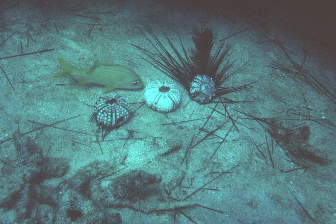
7 Harilaos Lessios - Diadema die-off - Looe Key NMS July 1983
 Why the Gulf of")
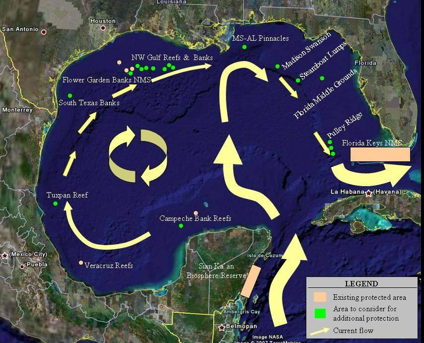
8 Current Drifters ( ) Credit: Kevin Leaman (UM/RSMAS) Why the Gulf of Mexico?

9 Water Circulation in the Gulf


10 Water Circulation Gulf of Mexico Regional Circulation Gulf Stream FLORIDA Loop Current Florid a Florida Current Bahamas Everglades Nat'l Park Biscayne Bay Cuba Yucatan Cape Sable Florida Bay Dry Tortugas Marquesas Keys Key West Pourtales Terrace Florida Current (Lee and Williams - Univ of Miami)

11 Florida Keys National Marine Sanctuary Marine Zones Sanctuary Preservation Areas Special-Use Areas Ecological Reserves Wildlife Management Areas Existing Management Areas


12 Why An International MPA Network? Spiny Lobster Fishery
13 Why the Gulf of Mexico? Example of Connectivity: Acropora palmata

14

15
16
17 Key Points About This Initiative The Administration has still not taken a formal position on the initiative. Rather, it is considering the merits of this initiative, along with other possibilities. NOAA has not taken any action on the concept. NOAA would not support the designation without a thorough public discussion of all the relevant issues.
18 Key Points About This Initiative A unique opportunity exists to protect special marine areas in the Gulf of Mexico. Functionally-connected network of the Nation s northernmost coral reefs, banks, ridges and pinnacles Ensure conservation of sensitive habitats and communities critical to the Gulf s most recognizable and threatened living resources would provide for uses compatible with the primary objective of conservation Would establish the largest and first ever internationally connected network of MPAs Will improve on ocean governance Apply an ecosystem-based approach to management Gulf of Mexico: ideal location energy and marine conservation can co-exist
19

20
21 Many of the areas identified on the map have already been set aside for some level of protection through MMS or Fisheries processes-- A great deal of public attention has already been given to these areas. The special marine areas proposed would still be assessed through a comprehensive stakeholder process. A proposed extension of current efforts with Mexico and Belize would provide for a full ecosystem approach and demonstrates leadership worldwide.


22 Staff of the Office of National Marine Sanctuaries has drafted a more comprehensive Site Characterization of the proposed sites.

23 South Texas Banks Original Map had a single dot this map is more specific.

24 Northwest Gulf Reefs & Banks Flower Garden Banks National Marine Sanctuary Management Plan Review since Oct 2006 Separate Process SAC recommended inclusion of 9 Banks

25 The Pinnacles Again more detailed sites.

26 Madison Swanson Steamboat Lumps Florida Middle Grounds Gulf of Mexico Concept


27 Florida Middle Grounds

28 Pulley Ridge Gulf of Mexico Concept


29 Pulley Ridge
30 Science Forum Hosted by Mote Marine Lab in Sarasota, Florida Over 100 scientists from around the Gulf attended. Objectives were to share information, identify gaps in knowledge, identify additional potential protected areas. Very preliminary results presented in this outline
31 Convened Six Expert Panels Panel on geology Panel on physical oceanography Panel on benthic ecology Panel on fisheries Panel on legal foundations Panel on international projects
32 The following is a sampling of some of the points made by the panel experts.
33 Panel 1: Geological Setting Al Hine (University of South Florida) presentation Niall Slowey (Texas A&M University) presentation Gene Shinn (U.S. Geological Survey, Emeritus) panelist Additional drilling and seismic investigations are necessary to improve our understanding of the geology of the region The northern end of Pulley Ridge has an area call the Sticky Grounds (because gear gets stuck there) that should be surveyed and characterized The Gulf of Mexico is an excellent place to examine past sea levels
34 Panel 2: Oceanographic Setting Villy Kourafalou (University of Miami/RSMAS) - presentation Bob Weisberg (USF) - presentation Liz Williams (UM/RSMAS) - panelist Libby Johns (NOAA Atlantic Oceanographic & Meteorological Lab.) panelist A gap in our knowledge concerns dynamics of the Loop Current, which is quite variable, and subsurface profiles of water characteristics and flows Bottom currents transport fish larvae across the West Florida Shelf, which is stratified There obviously is connectivity among the Islands in the Stream and improving our understanding of the details is an important next step Paul Sammarco (LUMCON) is investigating coral genetics from the Flower Garden Banks to Mobile, which will provide evidence about gene flow and connectivity for these species
35
36 Panel 3: Benthic Characterizations Emma Hickerson (NOAA Flower Garden Banks NMS) - presentation Bill Precht (Battelle) - presentation Walt Jaap (USF and Lithophyte Research) presentation The area surrounding the Flower Garden Banks is rich with additional banks, a number of which are being considered for inclusion in the sanctuary in a public process currently underway and separate from the Gulf of Mexico concept The first living colonies of elkhorn coral on the FGB were discovered in 2003 and 2005; preliminary paleontological surveys indicate that this coral was common from 10,000 until 6,000 years ago, when this community lagged behind rapidly rising sea level and was replaced by other corals Southern Pulley Ridge may be the deepest coral reef in the U.S., with several species of coral and algae thriving at depths of m.
37 Panel 4: Fish and Fisheries Characterization/Spawning Aggregations Jerry Ault (UM/RSMAS) presentation Chris Koenig (Florida State Univ.) - presentation Will Heyman (TAMU) - presentation Doug Weaver (TAMU-Corpus Christi) panelist Fish populations in the Gulf typically display strong recruitment after hurricanes Tagged Tarpon show connectivity to Mexico and Belize Fish ranges show connectivity in some areas of the Gulf There is a pressing need for benthic habitat maps of the West Florida Shelf Fish spawning areas can be linked to specific benthic and oceanographic features Acoustic techniques are being used to investigate red grouper spawning behavior
38 Panel 5: Existing Legal Structure/Regulations in the Gulf of Mexico Shepherd Grimes (NOAA) - presentation James Sinclair (Minerals Management Service) presentation Existing Statues used in the Gulf includes: the National Marine Sanctuaries Act, the Outer Continental Shelf Lands Act, and the Magnuson-Stevens Act Habitat Areas of Particular Concern must meet one or more of four criteria: 1) the importance of the ecological function provided by the habitat, 2) the extent to which the habitat is sensitive to human-induced environmental degradation, 3) whether, and to what extent, development activities are, or will be, stressing the habitat type, and 4) the rarity of the habitat type. MMS manages additional types of area restrictions No Activity Zones and other zones of protection
39 Panel 6: Connections with Mexico and the Mesoamerican Barrier Reef System Libby Johns (AOML) - presentation Wes Tunnell (TAMU-CC/Harte Research Institute) presentation Bob Hueter (MML) presentation Investigations by oceanographers and fishery biologists are in progress to improve our understanding of larval dispersal from the MBRS in the Gulf The Mexican commission on protected areas (CONANP) includes a number of reef sites in the Gulf and along the MBRS The Ocean Tracking Network will provide a unique opportunity to investigate movements of large marine animals through the Yucatan and Florida Straits
40 Gulf of Mexico Concept Open Discussion on information gaps, research opportunities, opportunities for collaborations, internal and external management processes, how what is known about the Gulf supports/does not support establishment of an MPA network. Facilitation, Frank Alcock (MML) Should consider expanding the concept s spatial scale to include shallower shelf, deeper Lophelia banks, and areas such as De Soto Canyon There is an urgent need to create refugia from growing human threats Florida West shelf Hardbottom Habitats need to be included/represented Need to trust the substance of the available science and don t worry about what we don t have: 1) protect these sites, 2) networks enable ecological integrity, 3) the network will enhance fish production and is large enough, 4) the network will provide a test of ecosystem-based management, and 5) the network will demonstrate U.S. leadership in protecting marine resources These areas are connected and special the scientific validity of the concept depends on a larger-scale, integrated effort with Mexico, Belize and Cuba
41 Summary of/perspectives on the day s discussion, John Ogden (Florida Inst. of Oceanography) Marine Managed Area is not the same as Marine Protected Area is not the same as Marine Reserve levels of protection increase across these types of areas Networks are value-added both biologically and administratively scientific answers need to be gleaned in the context of management actions The Islands per se have enough science to support the concept and can serve as a focal point to further our understanding of marine resource protection Further research will show the pieces missing from the network, which will need to be more extensive both for ecological and human purposes The Islands in the Stream concept is a step in the larger process toward more comprehensive management of the sea as we do on land There is no answer about connectivity of the Islands science can only shrink the envelope of uncertainty
42 Possible Management Opportunities Provides an opportunity for holistic and complete management of the special marine areas in the Gulf of Mexico without limitations on the uses Long-term management and protection would be established after a thorough public process under the highly collaborative and inclusive NMS Act designation process. Long-term management of these MPAs would be collaborative and coordinated Will take into account current management measures in place under other authorities such as the Outer Continental Shelf Lands Act, the Magnuson-Stevens Fishery Conservation and Management Act, and the Clean Water Act.
43 Fishing The initiative is targeted in that only small discrete areas will be subject to additional protection Most areas considered are already subjected to some form of fishing restrictions under the Magnuson-Stevens Fishery Conservation and Management Act Provides a unique opportunity to study the benefits of MPAs in ecosystem management The initiative would be designed to establish management options based on sound science and after a thorough public process
44 The Islands- the special places- in the Stream (Loop Current) in the US include: South Texas Banks Flower Garden Banks National Marine Sanctuary North Texas-Louisiana Banks Mississippi-Alabama Shelf Pinnacles Madison Swanson Florida Middle Grounds Steamboat Lumps Pulley Ridge Florida Keys National Marine Sanctuary/Tortugas Ecological Reserve
45 Flower Garden Banks NMS Management Plan Review Process Separate process but a center-piece of the MPA network Working with a well-balanced SAC Developing Alternatives for Boundary Expansion
46
47 General questions for stakeholders: How can all stakeholders in the Gulf of Mexico benefit from a network of marine protected areas? What would make a network effective? o Are small- discrete- areas the key? o What special features should constitute a network? o Are the features identified the best sites? o Are there features or places missing? What would constitute a meaningful stakeholder process?
48 Questions?
49 Islands in the Stream Concept
Sister Sanctuaries: Linking the Science and Management of Coral Reefs in Cuba and the U.S.
 Sister Sanctuaries: Linking the Science and Management of Coral Reefs in Cuba and the U.S. Memorandum of Understanding on Cooperation in the Conservation and Management of Marine Protected Areas Seventh
Marine Spatial Planning: A Tool for Implementing Ecosystem-Based Management
 Marine Spatial Planning: A Tool for Implementing Ecosystem-Based Management Steven Murawski, Ph.D., Ecosystem Goal Team Lead National Oceanic and Atmospheric Administration NOAA November 16, 2009 1 To
SW Florida Escarpment Mapping Area
 Overview NOAA s Okeanos Explorer (EX) Program plans to conduct systematic mapping and telepresence-enabled ROV explorations in the Gulf of Mexico during Spring 2014. In 2011, the EX conducted mapping operations
Assessment of Benthic Coral Reef Organisms in Dry Tortugas National Park and the Western Florida Keys National Marine Sanctuary
 Assessment of Benthic Coral Reef Organisms in Dry Tortugas National Park and the Western Florida Keys National Marine Sanctuary 2008 Quick Look Report and Data Summary December 2009 Steven L. Miller 1,
Biogeographic Approach to Coastal Assessments & Spatial Planning
 NOAA s Biogeographic Approach to Coastal Assessments & Spatial Planning Mark E. Monaco Mark.Monaco@noaa.gov Center for Coastal Monitoring and Assessment http://ccma.nos.noaa.gov/about/biogeography Biogeography
SoFLA-HYCOM (South Florida HYCOM) Regional Model around Florida Straits, Florida Bay and the Florida Keys: An overview FLORIDA.
 Regional Model around Florida Straits, Florida Bay and the Florida Keys: An overview FLORIDA.") SoFLA-HYCOM (South Florida HYCOM) Regional Model around Florida Straits, Florida Bay and the Florida Keys: An overview SW Florida shelf FLORIDA Florida Current B A H A M A S 25N CUBA 83W 79W Villy KOURAFALOU
SoFLA-HYCOM (South Florida HYCOM) Regional Model around Florida Straits, Florida Bay and the Florida Keys: An overview SW Florida shelf FLORIDA Florida Current B A H A M A S 25N CUBA 83W 79W Villy KOURAFALOU
SOUTHEAST OCEAN AND COASTAL ACIDIFICATION NETWORK. Scott Noakes, University of Georgia 2:00pm 2:30pm
 SOUTHEAST OCEAN AND COASTAL ACIDIFICATION NETWORK Scott Noakes, University of Georgia 2:00pm 2:30pm Agenda Overview of SOCAN SOCAN Mission Statement SOCAN Steering Committee SOCAN Executive Committee State
Science and Policy Considerations for Coastal and Marine Spatial Planning in the Wider Caribbean. John Ogden, University of South Florida
 Science and Policy Considerations for Coastal and Marine Spatial Planning in the Wider Caribbean John Ogden, University of South Florida The Caribbean is Ecologically and Politically Complex The Caribbean
Surface Radiocarbon in the Gulf of Mexico and Caribbean as Recorded in Corals
 Surface Radiocarbon in the Gulf of Mexico and Caribbean as Recorded in Corals Amy Wagner GREF Fellow Department of Oceanography Texas A&M University *Currently doing Sea Grant Fellowship with NOAA Climate
CLIMAR-III Third JCOMM Workshop on Advances in Marine Climatology 6-9 May Gdynia, Poland
 CLIMAR-III Third JCOMM Workshop on Advances in Marine Climatology 6-9 May 2008. Gdynia, Poland Catherine Marzin Historical Ecology Program Manager National Marine Sanctuary Program Stefan Claesson Research
BOEM Marine Minerals Program
 BOEM Marine Minerals Program Restoring and Protecting Our Nation s Coasts through Stewardship of OCS Sand Resources SECOORA 2018 Annual Meeting May 22-24 Doug Piatkowski Douglas.piatkowski@boem.gov 703-787-1833
DFO Maritimes Region Update. Gulf of Maine Council - Coastal and Marine Spatial Planning (CMSP) Committee Web-Ex May 16, 2017
 Committee Web-Ex May 16, 2017") DFO Maritimes Region Update Gulf of Maine Council - Coastal and Marine Spatial Planning (CMSP) Committee Web-Ex May 16, 2017 1 National Oceans Priorities Marine Conservation Targets Oceans Protection Plan
DFO Maritimes Region Update Gulf of Maine Council - Coastal and Marine Spatial Planning (CMSP) Committee Web-Ex May 16, 2017 1 National Oceans Priorities Marine Conservation Targets Oceans Protection Plan
Introduction: The Gulf of Mexico Alliance. The Gulf GAME project MERMAid and PHINS Results & Conclusions What s next? Examples
 AAG Las Vegas March 25, 2009 Introduction: Ocean governance and Ecosystem-Based Management The Gulf of Mexico Alliance Habitat Identification and Characterization The Gulf GAME project MERMAid and PHINS
Beyond the Horizon Creating a Network of Special Ocean Places to Strengthen the Ecology, Economy and Culture of the Gulf of Mexico
 Beyond the Horizon Creating a Network of Special Ocean Places to Strengthen the Ecology, Economy and Culture of the Gulf of Mexico This document proposes a new relationship with the Gulf of Mexico. One
Underwater Parks: Three Case Studies, and a Primer on Marine Boundary Issues. Robert E. Johnson Leland F. Thormahlen
 Robert E. Johnson Leland F. Thormahlen Underwater Parks: Three Case Studies, and a Primer on Marine Boundary Issues Unlike boundaries on land, most marine boundaries are not marked with monuments or fences.
Modeling dispersal kernals with limited. information. Douglas T. Fischer, Louis W. Botsford, David M. Kaplan, J. William White, John Largier
 Modeling dispersal kernals with limited http://www.nmfs.noaa.gov/habitat/ habitatprotection/profile/pacificcouncil.htm information Douglas T. Fischer, Louis W. Botsford, David M. Kaplan, J. William White,
Preliminary Results from Coordinated Sea-Level Rise Modeling Using SLAMM, the Sea Level Affecting Marshes Model, Across the US Gulf of Mexico Coast
 Preliminary Results from Coordinated Sea-Level Rise Modeling Using SLAMM, the Sea Level Affecting Marshes Model, Across the US Gulf of Mexico Coast James W. Pahl, Ph.D., and Kristin DeMarco, State of Louisiana
What larval culture of Diadema antillarum
 What larval culture of Diadema antillarum, the long-spined sea urchin, the keystone herbivore of western tropical Atlantic coral reefs, tells us about Keys water quality Martin A. Moe A disease in 1983
III. Acropora coral habitat distribution
 2008 Quick Look Report: Miller et al. III. Acropora coral habitat distribution Background The declines in abundance of two of the principal Caribbean reef-building corals, staghorn coral (Acropora cervicornis)
SEA GRANT LAW & POLICY JOURNAL VOL. 9:2 THE GULF OF MEXICO ECOSYSTEM: LINKING SHARED MARINE RESOURCES. William E. Kiene 1
 THE GULF OF MEXICO ECOSYSTEM: LINKING SHARED MARINE RESOURCES ACROSS INTERNATIONAL BORDERS THROUGH THE GULF S SPECIAL PLACES William E. Kiene 1 The Gulf of Mexico (Gulf) ecosystem, like its geography and
2012 FORUM OF MARINE PROTECTED AREAS IN THE MEDITERRANEAN ANTALYA, TURKEY
 2012 FORUM OF MARINE PROTECTED AREAS IN THE MEDITERRANEAN ANTALYA, TURKEY SPECIAL EVENT Challenges for Open Seas MPAs in the Mediterranean region November 27, 2012. 15h00-16H00 Slide # 1 2012 FORUM OF
Biogeographic Assessments to Meet Local & Regional Management Needs
 Biogeographic Assessments to Meet Local & Regional Management Needs August 2012 / NCCOS / Center for Coastal Monitoring and Assessment Center for Coastal Fisheries and Habitat Research Chris Jeffrey Chris.Jeffrey@noaa.gov
Northwestern Hawaiian Islands Coral Reef Research Partnership: Ocean Mapping, Ecosystem Threats, and Information Management
 Northwestern Hawaiian Islands Coral Reef Research Partnership: Ocean Mapping, Ecosystem Threats, and Information Management Malia Chow Papahanaumokuakea Marine National Monument National Oceanic and Atmospheric
WELCOME & INTRODUCTION
 MPA Management Capacity Building Training Module 1: WELCOME & INTRODUCTION Participants Distinguished Guests Welcome Site Overviews of MPAs represented Overview of Training Program What are Today s Objectives?
Hurricane Wilma Post Storm Data Acquisition Estimated Peak Wind Analysis and Storm Tide Data. December 27, 2005
 Hurricane Wilma Post Storm Data Acquisition Estimated Peak Wind Analysis and Storm Tide Data December 27, 2005 Hurricane Wilma was the sixth major hurricane of the record-breaking 2005 Atlantic hurricane
Brief report on Belize carbonate environments field trip Feb. 2012
 Brief report on Belize carbonate environments field trip Feb. 2012 In february 2012 I travelled to San Pedro (Ambergris Caye) Belize (Figure 1) to examine and study depositional environments of carbonate
Identifying Sensitive Marine Areas: A tour of the legal and scientific criteria
 Identifying Sensitive Marine Areas: A tour of the legal and scientific criteria CIL High Seas Governance: Gaps and Challenges Panel 1 on Sensitive Marine Areas 24-25 April 2017, Singapore Youna Lyons,
An international research expedition assess the biodiversity and health of New Caledonia coral reefs
 Nouméa, 28.11.2013. An international research expedition assess the biodiversity and health of New Caledonia coral reefs A research mission on coral reefs in New Caledonia conducted in association with
HAMILTON DECLARATION ON COLLABORATION FOR THE CONSERVATION OF THE SARGASSO SEA
 HAMILTON DECLARATION ON COLLABORATION FOR THE CONSERVATION OF THE SARGASSO SEA Hamilton, Bermuda 11 March, 2014 WE, THE SIGNATORIES LISTED BELOW: Recognising that the islands of Bermuda are the only land
IV. Distribution and Abundance of Acropora Corals
 IV. Distribution and Abundance of Acropora Corals Background The declines in abundance of two of the principal Caribbean reef-building corals, staghorn coral (Acropora cervicornis) and elkhorn coral (A.
SAFMC Habitat and Ecosystem IMS. Habitat and Environmental Protection Advisory Panel Meeting
 SAFMC Habitat and Ecosystem IMS Habitat and Environmental Protection Advisory Panel Meeting Charleston, SC November 18, 2008 Project Overview Phase 1 develop and host an Internet Map Server (IMS) application
East Coast whale, dolphin grounds to endure oil exploration blasts By McClatchy Washington Bureau, adapted by Newsela staff Oct.
 East Coast whale, dolphin grounds to endure oil exploration blasts By McClatchy Washington Bureau, adapted by Newsela staff Oct. 08, 2014 1:00 AM Pictured is a North Atlantic right whale (Eubalaena glacialis).
Designing Networks of Marine Protected Areas in DFO s Three Atlantic Bioregions
 Designing Networks of Marine Protected Areas in DFO s Three Atlantic Bioregions Presentation for Indigenous Protected Areas Workshop Max Westhead, DFO and Adrian Gerhartz-Abraham, Dalhousie March 29, 2017
Coral Reef Electronic Chart Initiative: Protecting Corals, Saving Ships
 Proceedings: US Hydrographic Conference 2005, 29-31 March 2005, San Diego, CA Coral Reef Electronic Chart Initiative: Protecting Corals, Saving Ships Dr. Lee Alexander Center for Coastal and Ocean Mapping
Summary of 2013 Activities
 Summary of 2013 Activities Name Affiliation Focus Area Frank Aikman NOAA-NOS Physical Cort Cooper, Chair Chevron Physical Dale Crockett Texas Water Development Board Coastal phys. Shejun Fan Shell (Formerly
III. Distribution and Abundance of Acropora Corals
 III. Distribution and Abundance of Acropora Corals Background The declines in abundance of two of the principal Caribbean reef-building corals, staghorn coral (Acropora cervicornis) and elkhorn coral (A.
Blueline Tilefish Assessment Approach: Stock structure, data structure, and modeling approach
 Blueline Tilefish Assessment Approach: Stock structure, data structure, and modeling approach Nikolai Klibansky National Oceanic and Atmospheric Administration August 28, 2017 Nikolai Klibansky (NOAA)
Marine Spatial Planning Leslie-Ann McGee Battelle Memorial Institute
 Marine Spatial Planning Leslie-Ann McGee Battelle Memorial Institute Rev061708 1 Marine Spatial Planning What is it? Why is it different? Where is it currently being employed? What is happening in the
EASTERN SCOTIAN SHELF INTEGRATED OCEAN MANAGEMENT PLAN
 Government of Canada Gouvernement du Canada EASTERN SCOTIAN SHELF INTEGRATED OCEAN MANAGEMENT PLAN SUMMARY Photo Credits: Bedford Institute of Oceanography Published by: Oceans and Habitat Branch Fisheries
Statutory framework of the world network of biosphere reserves UNESCO General Conference 1996
 Statutory framework of the world network of biosphere reserves UNESCO General Conference 1996 Keywords: conservation, protected areas, biosphere reserves, policies, strategies. For the Mountain Forum's
Enhancing predictability of the Loop Current variability using Gulf of Mexico Hycom
 Enhancing predictability of the Loop Current variability using Gulf of Mexico Hycom Matthieu Le Hénaff (1) Villy Kourafalou (1) Ashwanth Srinivasan (1) Collaborators: O. M. Smedstad (2), P. Hogan (2),
Climate Outlook through 2100 South Florida Ecological Services Office Vero Beach, FL September 9, 2014
 Climate Outlook through 2100 South Florida Ecological Services Office Vero Beach, FL September 9, 2014 Short Term Drought Map: Short-term (
Deepwater Horizon Gulf of Mexico Oil Spill NSF Rapid Response Research
 Deepwater Horizon Gulf of Mexico Oil Spill NSF Rapid Response Research Presentation to the Ocean Leadership 2011 Public Policy Forum Consortium for Ocean Leadership Dr. David Conover National Science Foundation
National Marine Sanctuary Program
 National Marine Sanctuary Program NMSP/USGS Joint Seabed Mapping Initiative: September 2004 AA National Ocean Service National Marine Sanctuaries Interim Report September 2004 Background: Since 2002,
Synthesis and Integrated Modeling of Long-term Data Sets to Support Fisheries and Hypoxia Management in the Northern Gulf of Mexico
 Synthesis and Integrated Modeling of Long-term Data Sets to Support Fisheries and Hypoxia Management in the Northern Gulf of Mexico Dan Obenour (Scientific/Hypoxia PI) Kevin Craig (Applications/Fisheries
Presentation for the Institute of International & European Affairs
 Presentation for the Institute of International & European Affairs Kathryn D. Sullivan, Ph.D. Under Secretary of Commerce for Oceans and Atmosphere & NOAA Administrator June 3, 2016 Overview NOAA 101 Closing
Marine Spatial Planning (MSP): A practical approach to ecosystembased
: A practical approach to ecosystembased") Marine Spatial Planning (MSP): A practical approach to ecosystembased management Erik Olsen, Institute of Marine Research, Norway Fanny Douvere, International Oceanographic Commission Overview Why we need
Marine Spatial Planning (MSP): A practical approach to ecosystembased management Erik Olsen, Institute of Marine Research, Norway Fanny Douvere, International Oceanographic Commission Overview Why we need
Offshore Video Survey and Oceanographic Analysis: Georges Bank to the Chesapeake project
 Non-Technical Synopsis of the Offshore Video Survey and Oceanographic Analysis: Georges Bank to the Chesapeake project Executive Summary Dave Bethoney Kristin Kleisner Mark Anderson Changsheng Chen Bradley
NOAA s OCM: Services, tools and collaboration opportunities & Puerto Rico s NE Marine Corridor as a case study
 NOAA s OCM: Services, tools and collaboration opportunities & Puerto Rico s NE Marine Corridor as a case study Dr. Antares Ramos Álvarez NOAA s Office of Coastal Management September 15 th, 2016 Conservation
Homework 9: Hurricane Forecasts (adapted from Pipkin et al.)
") November 2010 MAR 110 HW9 Hurricane Forecasts 1 Homework 9: Hurricane Forecasts (adapted from Pipkin et al.) Movement of Hurricanes The advance of a tropical storm or hurricane is controlled by the prevailing
November 2010 MAR 110 HW9 Hurricane Forecasts 1 Homework 9: Hurricane Forecasts (adapted from Pipkin et al.) Movement of Hurricanes The advance of a tropical storm or hurricane is controlled by the prevailing
Outline National legislative & policy context Regional history with ESSIM ESSIM Evaluation Phase Government Integration via RCCOM Regional ICOM Framew
 What MSP Implementation could change in the Maritimes Region Tim Hall, Regional Manager Oceans and Coastal Management Division Ecosystem Management Branch Fisheries and Oceans Canada Maritimes Region BIO
Population Trends Along the Coastal United States:
 Coastal Trends Report Series Population Trends Along the Coastal United States: 1980-2008 U.S. Department of Commerce National Oceanic and Atmospheric Administration National Ocean Service Assessing the
MEMORANDUM OF UNDERSTANDING ON THE CONSERVATION OF MIGRATORY SHARKS HABITAT CONSERVATION. (Prepared by the Advisory Committee)
") MEMORANDUM OF UNDERSTANDING ON THE CONSERVATION OF MIGRATORY SHARKS CMS/Sharks/MOS3/Doc.10.2 24 August 2018 Original: English 3 rd Meeting of the Signatories (Sharks MOS3) Monaco, 10 14 December 2018 Agenda
MEMORANDUM OF UNDERSTANDING ON THE CONSERVATION OF MIGRATORY SHARKS CMS/Sharks/MOS3/Doc.10.2 24 August 2018 Original: English 3 rd Meeting of the Signatories (Sharks MOS3) Monaco, 10 14 December 2018 Agenda
Name/ Affiliation: Ben Enticknap, Fishery Project Coordinator Alaska Marine Conservation Council Address: PO Box Anchorage, AK 99510
 Habitat Areas of Particular Concern (HAPC) Proposal Name/ Affiliation: Ben Enticknap, Fishery Project Coordinator Alaska Marine Conservation Council Address: PO Box 101145 Anchorage, AK 99510 Please check
Kate Labrum
 2010-2011 Bren Group Project Proposal Boats, Whales, & the Santa Barbara Channel: An economic analysis & policy options for reducing the risk of vessel strikes to endangered whales Bren Student Proposers
International Guidelines for Ecosystem-based, Marine Spatial Management
 International Guidelines for Ecosystem-based, Marine Spatial Management Charles Ehler and Fanny Douvere, Consultants Intergovernmental Oceanographic Commission and Man and the Biosphere Programme UNESCO
GROUNDFISH AMENDMENT 28 REGULATION DEVELOPMENT UPDATE
 Agenda Item I.2.a NMFS Report 1 September 2018 GROUNDFISH AMENDMENT 28 REGULATION DEVELOPMENT UPDATE In drafting regulations for the Council s final preferred alternative for Amendment 28, recommended
Chapter 02 The Sea Floor
 Chapter 02 The Sea Floor Multiple Choice Questions 1. One of the following is not one of the world's major ocean basins: A. Atlantic Ocean B. Arctic Ocean C. Indian Ocean D. Antarctic Ocean E. Pacific
Spatial Planning in Canada s Maritimes Region. Maritimes Region
 Spatial Planning in Canada s Maritimes Region Glen Herbert, Scott Coffen-Smout Smout,, and Tanya Koropatnick Oceans and Coastal Management Division Ecosystem Management Branch Fisheries and Oceans Canada
V. Urchin Abundance and Size
 V. Urchin Abundance and Size Background The 1983-84 Caribbean-wide mass mortality of the long-spined sea urchin Diadema antillarum represents one of the more spatially expansive and prolonged disturbances
CANADIAN HYDROGRAPHIC SERVICE & OCEANOGRAPHIC SERVICES
 CANADIAN HYDROGRAPHIC SERVICE & OCEANOGRAPHIC SERVICES Presentation to Warming of the North Conference Ottawa, March 2 nd, 2015 Denis Hains, Director General & Hydrographer General of Canada TIP OF THE
Mapping on the Edge: shoreline mapping for regulation and voluntary stewardship
 Western Washington University Western CEDAR Salish Sea Ecosystem Conference 2016 Salish Sea Ecosystem Conference (Vancouver, BC) Mapping on the Edge: shoreline mapping for regulation and voluntary stewardship
Gulf of Mexico Early Season Preview 2018 PROMISING FISHING CONDITIONS IN GULF OF MEXICO
 Gulf of Mexico Early Season Preview 2018 PROMISING FISHING CONDITIONS IN GULF OF MEXICO By Daniel C. Westhaver and Matthew A. Upton Introduction As in previous years, ROFFS is providing an early spring
Introduction to Part III Examining wildlife distributions and abundance using boat surveys
 Baseline Wildlife Studies in Atlantic Waters Offshore of Maryland: Final Report to the Maryland Department of Natural Resources and Maryland Energy Administration, 2015 Introduction to Part III Examining
STATEMENT OF CAPABILITY
 BELIZE MARINE CONSERVATION AND CLIMATE ADAPTATION PROJECT (MCCAP) Ministry of Forestry, Fisheries and Sustainable Development STATEMENT OF CAPABILITY Consultant for the Realignment of Boundaries and the
Inter State Large Navigable Rivers of the United States
 Inter State Large Navigable Rivers of the United States REVIEW OF NORTH AMERICAN BASINS: GREAT LAKES AND MISSISSIPPI RIVER HELEN A. BROHL, EXECUTIVE DIRECTOR US COMMITTEE ON THE MARINE TRANSPORTATION SYSTEM
Assessing, Monitoring, and Defending Coral Reefs with GIS
 Assessing, Monitoring, and Defending Coral Reefs with GIS Dr. Rich Snow and Dr. Mary Snow Applied Aviation Sciences Embry-Riddle Aeronautical University Daytona Beach, Florida It is estimated that 60%
Optimal Spectral Decomposition (OSD) for GTSPP Data Analysis
 for GTSPP Data Analysis") Optimal Spectral Decomposition (OSD) for GTSPP Data Analysis Peter C Chu (1),Charles Sun (2), & Chenwu Fan (1) (1) Naval Postgraduate School, Monterey, CA 93943 pcchu@nps.edu, http://faculty.nps.edu/pcchu/
Optimal Spectral Decomposition (OSD) for GTSPP Data Analysis Peter C Chu (1),Charles Sun (2), & Chenwu Fan (1) (1) Naval Postgraduate School, Monterey, CA 93943 pcchu@nps.edu, http://faculty.nps.edu/pcchu/
SARGASSUM EARLY ADVISORY SYSTEM (SEAS): A comparison of. Sargassum landing amounts vs cold fronts on the Gulf Coast. A Whitepaper from the SEAS Team
: A comparison of. Sargassum landing amounts vs cold fronts on the Gulf Coast. A Whitepaper from the SEAS Team") SARGASSUM EARLY ADVISORY SYSTEM (SEAS): A comparison of Sargassum landing amounts vs cold fronts on the Gulf Coast A Whitepaper from the SEAS Team By Brandon N. Hill, Andy Rydzak, Capt. Robert Webster,
SARGASSUM EARLY ADVISORY SYSTEM (SEAS): A comparison of Sargassum landing amounts vs cold fronts on the Gulf Coast A Whitepaper from the SEAS Team By Brandon N. Hill, Andy Rydzak, Capt. Robert Webster,
Population Dynamics of Gulf Blue Crabs. Caz Taylor & Erin Grey Department of Ecology & Evolutionary Biology Tulane University
 Population Dynamics of Gulf Blue Crabs Caz Taylor & Erin Grey Department of Ecology & Evolutionary Biology Tulane University Blue Crab Callinectes sapidus Economically important in the Atlantic and the
Assessing state-wide biodiversity in the Florida Gap analysis project
 University of Nebraska - Lincoln DigitalCommons@University of Nebraska - Lincoln Nebraska Cooperative Fish & Wildlife Research Unit -- Staff Publications Nebraska Cooperative Fish & Wildlife Research Unit
Stevns Klint SITE INFORMATION. IUCN Conservation Outlook Assessment 2014 (archived) Finalised on 27 October 2014
 Finalised on 27 October 2014") IUCN Conservation Outlook Assessment 2014 (archived) Finalised on 27 October 2014 Please note: this is an archived Conservation Outlook Assessment for Stevns Klint. To access the most up-to-date Conservation
IUCN Conservation Outlook Assessment 2014 (archived) Finalised on 27 October 2014 Please note: this is an archived Conservation Outlook Assessment for Stevns Klint. To access the most up-to-date Conservation
OCEANOGRAPHIC DATA MANAGEMENT
 OCEANOGRAPHIC DATA MANAGEMENT Presented to: Environmental Disaster Data Management Meeting Russ Beard Director, National Coastal Data Development Center Interim Science Coordinator, Gulf Restoration Council
Cross-border Maritime Spatial Plan for the Black sea - Romania and Bulgaria project
 Cross-border Maritime Spatial Plan for the Black sea - Romania and Bulgaria project in Romania and Bulgaria Plan Presentation A first step in the management of the marine areas of Romania and Bulgaria
IWG-OCM Update For NCSS
 IWG-OCM Update For NCSS Data Supporting Science and Sound Decision-Making Ashley Chappell January 9, 2018 NOAA IOCM Coordination Team Members National Environmental Satellite, Data and Information Service:
Annex I. Common criteria for the choice of Protected Marine and Coastal Areas that could be included in SPAMI list
 Annex I Common criteria for the choice of Protected Marine and Coastal Areas that could be included in SPAMI list PROTOCOL CONCERNING SPECIALLY PROTECTED AREAS AND BIOLOGICAL DIVERSITY IN THE MEDITERRANEAN
The surface of the ocean floor is as varied as the land. The five major oceans, from largest to smallest, are
 11.1 Ocean Basins The surface of the ocean floor is as varied as the land. The five major oceans, from largest to smallest, are w the Pacific w the Atlantic w the Indian w the Southern w the Arctic The
Physical factors driving the oceanographic regime around the Florida Keys. Villy Kourafalou. University of Miami/RSMAS
 Physical factors driving the oceanographic regime around the Florida Keys Villy Kourafalou University of Miami/RSMAS Oceanographic connectivity around the Florida Keys LC FC http://oceancurrents.rsmas.miami.edu/atlantic/loop-current_2.html
Technologies for sea bottom inhabitants' monitoring and Integral Costal Zones Management. Example of the Kandalaksha Bay, White Sea
 Technologies for sea bottom inhabitants' monitoring and Integral Costal Zones Management. Example of the Kandalaksha Bay, White Sea Mikhail Tokarev, Roman Pevzner Transfer Technology Office of Lomonosov
IMA s ROLE IN COASTAL AND OCEAN GOVERNANCE IN TRINIDAD AND TOBAGO
 IMA s ROLE IN COASTAL AND OCEAN GOVERNANCE IN TRINIDAD AND TOBAGO Presented by Rahanna Juman, Deputy Director (Ag.) About the Institute of Marine Affairs Institute of Marine Affairs (IMA) was established,
7B.4 ASSESSMENT OF THE GROSS U.S. OFFSHORE WIND ENERGY POTENTIAL
 7B.4 ASSESSMENT OF THE GROSS U.S. OFFSHORE WIND ENERGY POTENTIAL Marc Schwartz, Donna Heimiller, Steve Haymes, and Walt Musial National Renewable Energy Laboratory, Golden, Colorado 1. INTRODUCTION Offshore
Presented by Bjarne Lyberth, Inuit Circumpolar Council Greenland, Executive Science Advisor,
 Template for Submission of Scientific Information to Describe Areas Meeting Scientific Criteria for Ecologically or Biologically Significant Marine Areas Title/Name of the area: Presented by Bjarne Lyberth,
The European Union and its Overseas Entities
 The European Union and its Overseas Entities Strategies in the face of climate change and biodiversity loss Reunion Island, 07-11 July 2008 An official event under the EU French Presidency International
Statutory Framework of Biosphere Reserves. The Statutory Framework of the World Network of Biosphere Reserves
 Page 1 of 5 The Statutory Framework of the World Network of Biosphere Reserves Introduction Article 1 - Definition Article 2 - World Network of Biosphere Reserves Article 3 - Functions Article 4 - Criteria
The United States & Canada. A Regional Study of Anglo America
 A Regional Study of Anglo America Landform Regions of the United States & Canada world leaders in agricultural and industrial production because of... VAST LANDS stretch from the Atlantic Ocean on the
Papahanaumokuakea 11 th Pacific Science Inter-congress Papeete, Tahiti. March 2009
 Papahanaumokuakea 11 th Pacific Science Inter-congress Papeete, Tahiti March 2009 Biological and Biogeographic Significance A few Monumental facts Largest fully protected marine protected area on Earth
Alaska Ocean Observing System 101 Anchorage, Alaska
 Alaska Ocean Observing System 101 Anchorage, Alaska Molly McCammon, Director Alaska Ocean Observing System (AOOS) A Regional Observing System within the Integrated Ocean Observing System www.aoos.org IOOS
NOAA Nautical Charts and Coastal and Marine Spatial Planning. Meredith Westington Chief Geographer NOAA/NOS/Office of Coast Survey
 NOAA Nautical Charts and Coastal and Marine Spatial Planning Meredith Westington Chief Geographer NOAA/NOS/Office of Coast Survey Ocean Policy Task Force What is CMSP? A comprehensive, adaptive, integrated,
Environmental Documents Prepared for Proposed Oil, Gas, and Mineral Operations by the Gulf of Mexico Outer Continental Shelf (OCS) Region
 Region") This document is scheduled to be published in the Federal Register on 03/27/2012 and available online at http://federalregister.gov/a/2012-07364, and on FDsys.gov Billing Code: 4310-MR DEPARTMENT OF THE
This document is scheduled to be published in the Federal Register on 03/27/2012 and available online at http://federalregister.gov/a/2012-07364, and on FDsys.gov Billing Code: 4310-MR DEPARTMENT OF THE
3. The diagram below shows how scientists think some of Earth's continents were joined together in the geologic past.
 1. The map below shows the present-day locations of South America and Africa. Remains of Mesosaurus, an extinct freshwater reptile, have been found in similarly aged bedrock formed from lake sediments
NOAA Seafloor Mapping in the Pacific Islands Region
 NOAA Seafloor Mapping in the Pacific Islands Region NOAA Coral Reef Ecosystem Division Pacific Island Fisheries Science Center Mission Statement Conduct research that provides scientific information and
OCEANS, CORAL REEFS NOAA
 1 of 5 From the HORIZON Solutions Site, www.solutions-site.org OCEANS, CORAL REEFS NOAA Helps National Coral Reef Institute Grow Coral in Laboratory for Transplantation to Damaged Reefs By Mar 2, 2008,
Marine Protected Area Network Planning in the Bay of Fundy and Scotian Shelf. Progress to date and next steps
 Marine Protected Area Network Planning in the Bay of Fundy and Scotian Shelf Progress to date and next steps Max(ine) Westhead, M.Sc. Section Head, Protected Areas and Conservation Planning Fisheries and
Post-Graduation Plans stock assessment scientist (NOAA, hopefully)
") Update Report Period 3/1/2013-2/28/2014 Project E/I-20 - NMFS Population Dynamics Sea Grant Graduate Fellowship An evaluation of the stock assessment method for eastern Bering Sea snow crab incorporating
Update Report Period 3/1/2013-2/28/2014 Project E/I-20 - NMFS Population Dynamics Sea Grant Graduate Fellowship An evaluation of the stock assessment method for eastern Bering Sea snow crab incorporating
Edwin A. Hernández-Delgado*
 Long-term Coral Reef Ecological Change Monitoring Program of the Luis Peña Channel Marine Fishery Reserve, Culebra Island, Puerto Rico: I. Status of the coral reef epibenthic communities (1997-2002). Edwin
NOAA/University of New Hampshire Joint Hydrographic Center & Center for Coastal and Ocean Mapping. MAPPS Summer Conference July 23, 2013
 NOAA/University of New Hampshire Joint Hydrographic Center & Center for Coastal and Ocean Mapping MAPPS Summer Conference July 23, 2013 07/23/2013 2 07/23/2013 3 Center Goals To be a world leader in the
Coral Reefs Editorial Team
 Coral Reefs Editorial Team Editor in Chief Professor Rolf PM Bak works at the Royal Netherlands Institute for Sea Research and holds the chair of Tropical Marine Biology at the University of Amsterdam.
West Florida Shelf and Tampa Bay Responses to Hurricane Irma: What Happened and Why
 West Florida Shelf and Tampa Bay Responses to Hurricane Irma: What Happened and Why R.H. Weisberg Y. Liu J. Chen College of Marine Science University of South Florida St. Petersburg, FL SECOORA Webinar
Gulf and Caribbean Research
 Gulf and Caribbean Research Volume 19 Issue 1 January 2007 Use of Diadema antillarum Spines by Juvenile Fish and Mysid Shrimp Taryn Townsend Montclair State University Paul A.X. Bologna Montclair State
THE SEVILLE STRATEGY ON BIOSPHERE RESERVES
 THE SEVILLE STRATEGY ON BIOSPHERE RESERVES 1 VISION FOR BIOSPHERE RESERVES IN THE 21 ST CENTURY The international Seville Conference on Biosphere Reserves, organised by UNESCO, adopted a two-pronged approach,