Application of GIS tools and techniques for better urban planning
|
|
|
- Alexandra Hampton
- 6 years ago
- Views:
Transcription
1 Application of GIS tools and techniques for better urban planning Dr. Sandeep Maithani Scientist Dept. of Urban and Regional studies Indian Institute of Remote sensing (ISRO)
2 Urban planning is a spatial activity ( we need accurate maps)
3
4
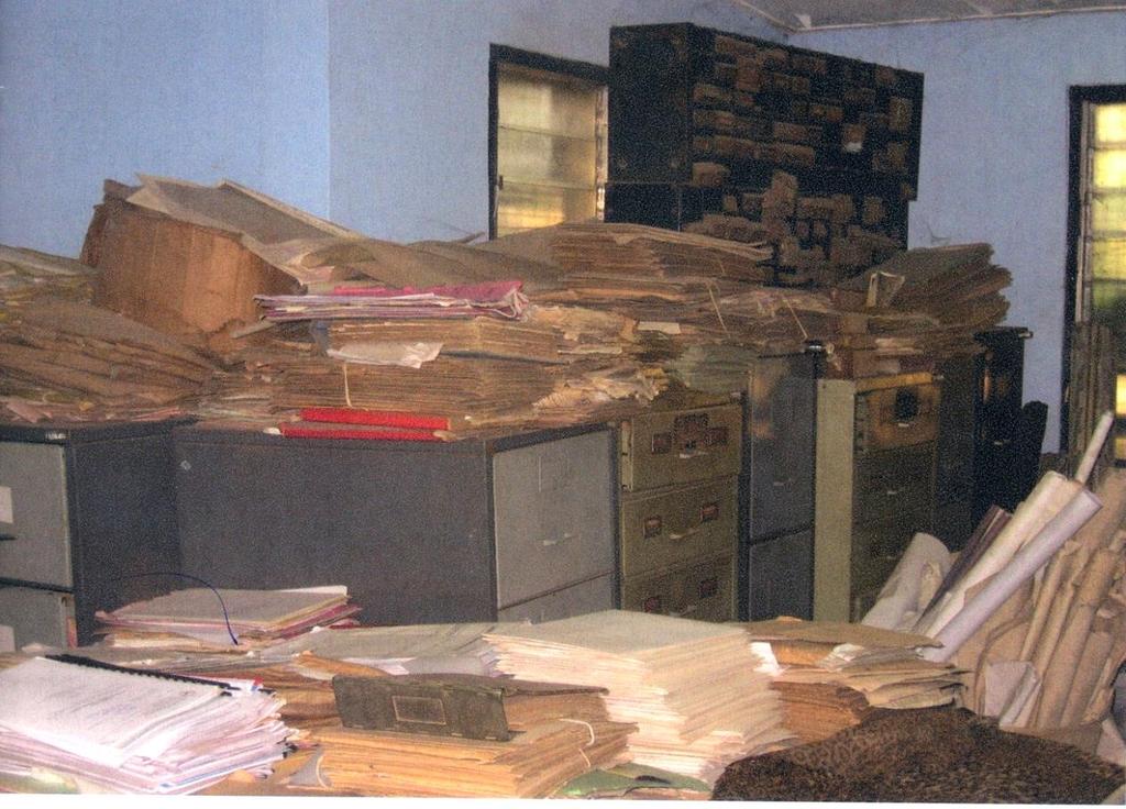
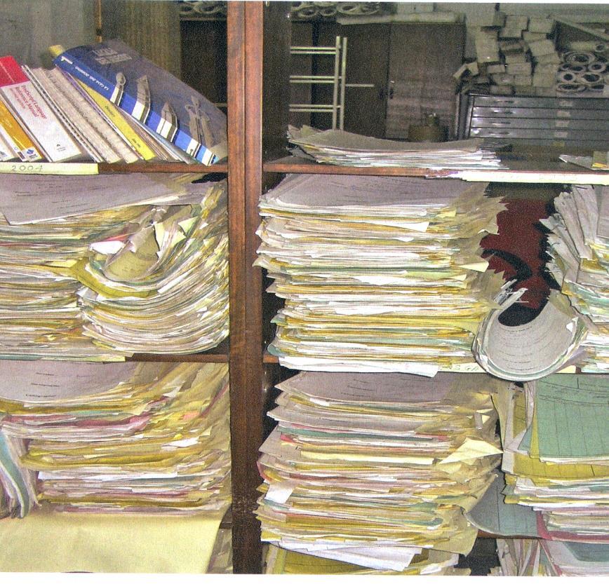
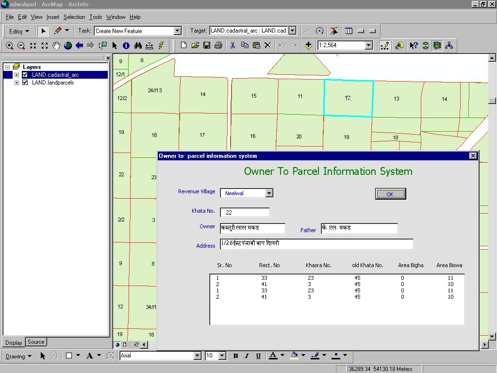
5 Conventional Method of Record Keeping
6 Role of Remote Sensing and GIS?
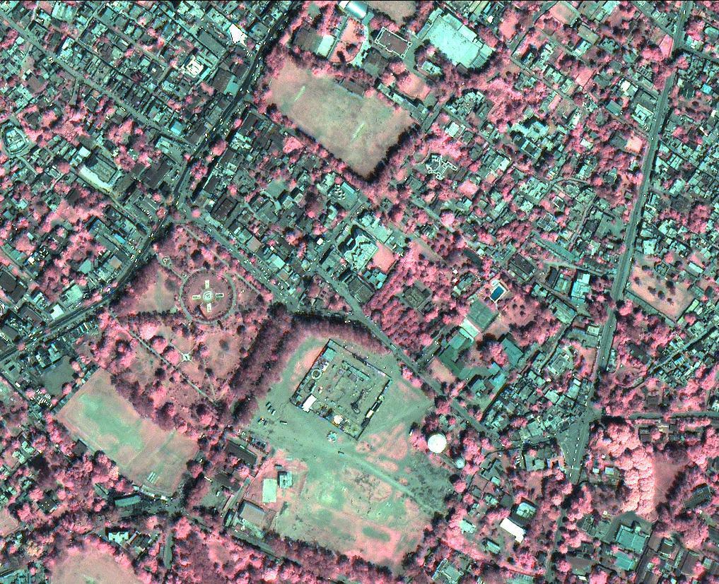
7 Remote Sensing & GIS: tools in urban planning Remote Sensing Spatial data provider GIS (Geographical Information system) Spatial data handler
8


9 Remote sensing: Spatial data provider GIS: Spatial data handler
10 Some of the applications Urban Seismic Risk Assessment. Network Analysis. Land cover/ Land use change modelling.
11 URBAN SEISMIC RISK ASSESSMENT

12 Preparedness Reduce losses

13 Need of urban risk assessment? Risk assessment THE AIM IS TO QUANTIFY THE LOSS DUE TO DISASTERS OF VARYING MAGNITUDE
 Lifeline Damage Assessment PGA, MMI estimates Building Loss")
14 APPROACH / METHODOLOGY: Lifeline Inventory Maps ( water supply, sewer, road networks) PGA, MMI Value (Age, condition, type etc) Lifeline Damage Assessment PGA, MMI estimates Building Loss Assessment
15 LANDUSE OF THE AREA The residential area sq mts. Commercial areas sq mts. Open space sq mts. Roads in the area sq mts. Utility buildings sq mts. Total area sq mts.
16
17 BUILDING AGE BUILDING AGE 18% 39% 43% NEW MO DERATELY O LD O LD/VERY O LD Newly Built houses 289 Moderately old houses 317 Very old houses Urban Seismic Risk Assessment in Dehradun city using GIS and Remote Sensing


18 PROXIMITY BETWEEN BUILDINGS Within 2 feet 285 Within 3 feet 232 Within 4 feet 152 Within 5 feet 32 Within 6 to 22 feet - 36 Urban Seismic Risk Assessment in Dehradun city using GIS and Remote Sensing
19 NO. OF STOREYS NO. O F STO REYS 32% 68% GRO UND FLO O R GRO UND + FIRST FLO O R Ground floor (G) 502 G + First floor 236 Urban Seismic Risk Assessment in Dehradun city using GIS and Remote Sensing
20 RATIONALE FOR DAMAGE ASSESSMENT Damage probability matrix (DPM) Class Type Roof Symmetry Maintenance Age Remarks A Load Bearing GI/Other Any Low Any ~Slum A1 Any Any Any NA NA Under Con B Load Bearing GI Any Any Any B1 Load Bearing GI-RCC Symmetrical Moderate Old Abandoned C1 Load Bearing RBC/RBC-GI Asymmetric Any Old/Mod C2 Load Bearing RBC/RBC-RCC Symmetric Any Old/Mod C3 Load Bearing RCC/RCC Any Any Mod/Old D1 Framed RCC Symmetric Low Old D2 Framed RCC/GI Asymmetric Moderate Old D3 Framed RCC Any Any Mod/New D4 Framed RCC Any High New E Steel/GI Steel Symmetric High Any All Steel MMI/Type A A1 B B1 C1 C2 C3 D1 D2 D3 D4 E V VI VII VIII IX X XI Probability > 75% is taken as Total Collapse Probability 50 75% is taken as major structural failure Probability 30 50% is taken as major damage failure Probability 5 30% is taken as minor damage Probability < 5% is taken as little or no damage
21 BUILDING VULNERABILITY ASSESSMENT
22 BUILDING VULNERABILITY ASSESSMENT
23 BUILDING VULNERABILITY ASSESSMENT
24 PROBABILITY OF DAMAGE FOR BUILDINGS MINOR DAMAGE Urban Seismic Risk Assessment in Dehradun city using GIS and Remote Sensing
25 OWNERSHIP AND TENANCY OWNERSHIP AND TENANCY OWNERSHIP O OAND R TENANT TENANCY NO. OF BUILDINGS O WNER 91 TENANT Owners residing in the same building 647 Only tenants residing - 91
26 QUERY 1 RESIDENTIAL + CLOSE PROXIMITY + ASYMMETRICAL SHAPE + POOR MAINTENANCE + MODERATELY/OLDER + LOAD BEARING + RBC ROOF = 463 HOUSES!
27 QUERY 2 RESIDENTIAL + PROXIMITY >4 FEET + SYMMETRICAL SHAPE + GOOD MAINTENANCE + NEWLY BUILT + FRAMED STRUCTURES + RCC ROOF Urban Seismic Risk Assessment in Dehradun city using GIS and Remote Sensing = 209 HOUSES!

28 Blocked road
29 ATTRIBUTES OF ROAD
30 BUILDINGS AFFECTING ROADS AT DIFFERENT EARTHQUAKE INTENSITIES Urban Seismic Risk Assessment in Dehradun city using GIS and Remote Sensing
31 BUILDINGS AFFECTING ROADS AT DIFFERENT EARTHQUAKE INTENSITIES Urban Seismic Risk Assessment in Dehradun city using GIS and Remote Sensing
32 BUILDINGS AFFECTING ROADS AT DIFFERENT EARTHQUAKE INTENSITIES Urban Seismic Risk Assessment in Dehradun city using GIS and Remote Sensing

33 KARANPUR ROAD BLOACKAGE
34 POPULATION AT RISK Urban Seismic Risk Assessment in Dehradun city using GIS and Remote Sensing
COMPREHENSIVE GIS-BASED SOLUTION FOR ROAD BLOCKAGE DUE TO SEISMIC BUILDING COLLAPSE IN TEHRAN
 COMPREHENSIVE GIS-BASED SOLUTION FOR ROAD BLOCKAGE DUE TO SEISMIC BUILDING COLLAPSE IN TEHRAN B. Mansouri 1, R. Nourjou 2 and K.A. Hosseini 3 1 Assistant Professor, Dept. of Emergency Management, International
AUTOMATED BUILDING DETECTION FROM HIGH-RESOLUTION SATELLITE IMAGE FOR UPDATING GIS BUILDING INVENTORY DATA
 13th World Conference on Earthquake Engineering Vancouver, B.C., Canada August 1-6, 2004 Paper No. 678 AUTOMATED BUILDING DETECTION FROM HIGH-RESOLUTION SATELLITE IMAGE FOR UPDATING GIS BUILDING INVENTORY
Interpretive Map Series 24
 Oregon Department of Geology and Mineral Industries Interpretive Map Series 24 Geologic Hazards, and Hazard Maps, and Future Damage Estimates for Six Counties in the Mid/Southern Willamette Valley Including
REAL-TIME ASSESSMENT OF EARTHQUAKE DISASTER IN YOKOHAMA BASED ON DENSE STRONG-MOTION NETWORK
 REAL-TIME ASSESSMENT OF EARTHQUAKE DISASTER IN YOKOHAMA BASED ON DENSE STRONG-MOTION NETWORK Saburoh MIDORIKAWA 1 And Susumu ABE 2 SUMMARY This paper describes a system for REal-time Assessment of earthquake
Towards a rapid, multi-scale assessment of earthquake vulnerability
 United Nations International Conference on Space-based Technologies for Disaster Risk Management Best Practices for Risk Reduction and Rapid Response Mapping 22-25 November, Beijing Towards a rapid, multi-scale
Disaster Risk Assessment: Opportunities for GIS and data management with Open DRI
 Disaster Risk Assessment: Opportunities for GIS and data management with Open DRI Jacob Opadeyi Department of Geomatics Engineering and Land Management, The University of the West Indies, St. Augustine,
ENGINEERING-SEISMOLOGICAL ASPECTS OF EARTHQUAKE SCENARIO DEVELOPMENT ON THE EXAMPLE OF TASHKENT, UZBEKISTAN
 International Journal of Geology, Earth & Environmental Sciences ISSN: 2277-281 (Online) 218 Vol. 8 (2) May-August, pp. 3-35/Alixanovich ENGINEERING-SEISMOLOGICAL ASPECTS OF EARTHQUAKE SCENARIO DEVELOPMENT
Downtown Anchorage Seismic Risk Assessment & Land Use Regulations to Mitigate Seismic Risk
 Prepared for: The Municipality of Anchorage Planning Department and the Geotechnical Advisory Commission Downtown Anchorage Seismic Risk Assessment & Land Use Regulations to Mitigate Seismic Risk Prepared
We greatly appreciate the review of the manuscript by the anonymous referee#3. We hereby put forth the clarifications as follows.
 Point by point response to the observations & comments of Anonymous Reviewer # 3 on the manuscript titled Seismic Vulnerability & Risk Assessment of Kolkata City, India (ms# nhess-2013-467) We greatly
DEVELOPING A TRANSPORTATION PLAN FOR EVACUATION OF BUILDUP AREAS IN CASE OF EARTHQUAKE "CASE STUDY"
 DEVELOPING A TRANSPORTATION PLAN FOR EVACUATION OF BUILDUP AREAS IN CASE OF EARTHQUAKE "CASE STUDY" Osama A. Abaza Associate Professor, Civil Engineering Dept., University of Alaska Anchorage, Anchorage,
The Magnitude 7.2 Earthquake from the West Valley Fault: Implications for Metro Manila and Nearby Provinces
 The Magnitude 7.2 Earthquake from the West Valley Fault: Implications for Metro Manila and Nearby Provinces First DRI Collegiate Conference in the Philippines 16 March 2017 Renato U. Solidum, Jr. Department
SEISMIC VULNERABILITY ASSESSMENT USING HIGH RESOLUTION SATELLITE DATA AND FIELD STUDIES
 P. Anbazhagan, V.T. Giridhar, Ganesha Raj K. and V. Shreedhara 267 SEISMIC VULNERABILITY ASSESSMENT USING HIGH RESOLUTION SATELLITE DATA AND FIELD STUDIES P. Anbazhagan, 1 V.T. Giridhar, 2 Ganesha Raj
ASSESSMENT OF TRAFFIC DISTURBANCE CONSIDERING EARTHQUAKE IN SNOW SEASON
 ASSESSMENT OF TRAFFIC DISTURBANCE CONSIDERING EARTHQUAKE IN SNOW SEASON Toshihiko MIZUTA 1 1 Associate Professor, Dept. of Civil and Environmental Engineering, Akita National College of Technology, 1-1,
APPLICATIONS OF EARTHQUAKE HAZARD MAPS TO LAND-USE AND EMERGENCY PLANNING EXAMPLES FROM THE PORTLAND AREA
 APPLICATIONS OF EARTHQUAKE HAZARD MAPS TO LAND-USE AND EMERGENCY PLANNING EXAMPLES FROM THE PORTLAND AREA O. Gerald Uba Metro, Portland, Oregon OVERVIEW The extent to which we understand "below ground"
Earthquake Risk in Canada and the National Building Code
 Earthquake Risk in Canada and the National Building Code Tuna Onur, Ph.D. Onur Seemann Consulting, Inc. NICC, Vancouver, BC, 28-30 September 2016 Southwestern Canada: Cascadia Subduction Zone + Crustal
Labs. Exposure modeling. Dr. Keiko Saito GFDRRLabs, The World Bank
 Labs Exposure modeling Dr. Keiko Saito GFDRRLabs, The World Bank Labs Risk Modeling Hazard (e.g. hurricane wind) Exposure (e.g. houses) Vulnerability (e.g. of house to wind) Risk (e.g. probable loss) From
SCENARIO DESIGN ON THE IMPACT OF A HIGH-MAGNITUDE EARTHQUAKE IN THE CITY OF LIMA, PERU
 SCENARIO DESIGN ON THE IMPACT EARTHQUAKE IN THE CITY OF LIMA, Methodology Determination of the characteristics of the probable earthquake (magnitude, intensity, acceleration). Seismic geotechnical soil
A LIFELINE VULNERABILITY STUDY OF CONSTANTINE, ALGERIA
 A LIFELINE VULNERABILITY STUDY OF CONSTANTINE, ALGERIA Mounir AIT BELKACEM 1, Mehdi BOUKRI 2, Omar AMELLAL 3, Mohammed Naboussi FARSI 4, Abderrahmane KIBBOUA 5, Mounir NAILI 6 and Nacim YOUSFI 7 ABSTRACT
GIS-BASED EARTHQUAKE DISASTER PREDICTION AND OPTIMUM PATH ANALYSIS FOR THE URBAN ROAD TRANSIT SYSTEM
 GIS-BASED EARTHQUAKE DISASTER PREDICTION AND OPTIMUM PATH ANALYSIS FOR THE URBAN ROAD TRANSIT SYSTEM ABSTRACT: NI Yongjun 1, WANG Wanhong 1, HUANG Shimin 2, FU Shengcong 2 and OU Xianren 3 1. Ph.D, Associate
Important Concepts. Earthquake hazards can be categorized as:
 Lecture 1 Page 1 Important Concepts Monday, August 17, 2009 1:05 PM Earthquake Engineering is a branch of Civil Engineering that requires expertise in geology, seismology, civil engineering and risk assessment.
VULNERABILITY FUNCTIONS FOR BUILDINGS BASED ON DAMAGE SURVEY DATA IN SRI LANKA AFTER THE 2004 INDIAN OCEAN TSUNAMI. Murao, O. 1, Nakazato, H.
 371 VULNERABILITY FUNCTIONS FOR BUILDINGS BASED ON DAMAGE SURVEY DATA IN SRI LANKA AFTER THE 2004 INDIAN OCEAN TSUNAMI Murao, O. 1, Nakazato, H. 2 1 Graduate School of Systems and Information Engineering,
Preliminary Earthquake Risk Management Strategy Plan of Eskisehir, Turkey by using GIS
 Preliminary Earthquake Risk Management Strategy Plan of Eskisehir, Turkey by using GIS Metin Altan, Ferah Özturk and Can Ayday Space and Satellite Sciences Research Institute Anadolu University, TURKEY
Site Suitability Analysis for Urban Development: A Review
 Site Suitability Analysis for Urban Development: A Review Santanu Kumar Misra Associate Professor (Dept. of CSE) Sikkim Manipal Institute of Technology Majitar, Sikkim misra_santanu@rediffmail.com Shrijana
Performing seismic scenarios in the Luchon-Val d Aran area, Central Pyrenees
 Performing seismic scenarios in the Luchon-Val d Aran area, Central Pyrenees 7th EUROGEO, Bologna, Italy, 12th-15th june 2012 Authors: A. Roullé (BRGM), A. Macau (IGC), S. Figueras (IGC), D. Monfort- Climent
HAZUS-MH: Earthquake Event Report
 HAZUS-MH: Earthquake Event Report Region Name: El Paso County Earthquake Scenario: El Paso County Random EQ Print Date: February 08, 2006 Disclaimer: The estimates of social and economic impacts contained
Introduction. Thematic Mapping for Disaster Risk Assessment in Case of Earthquake FIG Working Week
 Thematic Mapping for Disaster Risk Assessment in Case of Earthquake Silvia MARINOVA, Temenoujka BANDROVA, Mihaela KOUTEVA-GUENTCHEVA, Stefan BONCHEV University of Architecture, Civil Engineering and Geodesy
M-8.1 EARTHQUAKE 87KM SW OF PIJIJIAPAN, MEXICO EXACT LOCATION: N W DEPTH: 69.7KM SEPTEMBER 7, 11:49 PST
 M-8.1 EARTHQUAKE 87KM SW OF PIJIJIAPAN, MEXICO EXACT LOCATION: 15.068 N 93.715 W DEPTH: 69.7KM SEPTEMBER 7, 2017 @ 11:49 PST Photo: Luis Alberto Cruz / AP Photo: Carlos Jasso 1 THE 2017 CHIAPAS MEXICO
Application of high-resolution (10 m) DEM on Flood Disaster in 3D-GIS
 DEM on Flood Disaster in 3D-GIS") Risk Analysis V: Simulation and Hazard Mitigation 263 Application of high-resolution (10 m) DEM on Flood Disaster in 3D-GIS M. Mori Department of Information and Computer Science, Kinki University, Japan
Risk Analysis V: Simulation and Hazard Mitigation 263 Application of high-resolution (10 m) DEM on Flood Disaster in 3D-GIS M. Mori Department of Information and Computer Science, Kinki University, Japan
A Feasibility Study about Extraction Method of Densely Crowded Areaswith Wooden Buildings in the KOBE Government. Part II 1)
") A Feasibility Study about Extraction Method of Densely Crowded Areaswith Wooden Buildings in the KOBE Government. Part II 1) Consideration of evaluation of urban fire hazard. Ritsu KATAYAMA Dept. of Architecture,
A Feasibility Study about Extraction Method of Densely Crowded Areaswith Wooden Buildings in the KOBE Government. Part II 1) Consideration of evaluation of urban fire hazard. Ritsu KATAYAMA Dept. of Architecture,
M 7.1 EARTHQUAKE 5KM ENE OF RABOSO, MEXICO EXACT LOCATION: N W DEPTH: 51.0KM SEPTEMBER 19, 1:14 LOCAL TIME
 M 7.1 EARTHQUAKE 5KM ENE OF RABOSO, MEXICO EXACT LOCATION: 18.584 N 98.399 W DEPTH: 51.0KM SEPTEMBER 19, 2017 @ 1:14 LOCAL TIME Photo: Eduardo Verdugo / AP Photo: Alfredo Estrella/ Agence France-Presse/
3D Seismic Hazard and Risk Maps for Earthquake Awareness of Citizens with Aids of GIS and Remote Sensing Technologies
 3D Seismic Hazard and Risk Maps for Earthquake Awareness of Citizens with Aids of GIS and Remote Sensing Technologies Saburoh Midorikawa Tokyo Institute of Technology In Japan, seismic hazard and risk
Application of a GIS for Earthquake Hazard Assessment and Risk Mitigation in Vietnam
 Application of a GIS for Earthquake Hazard Assessment and Risk Mitigation in Vietnam Nguyen Hong Phuong Earthquake Information and Tsunami Warning Centre, VAST OUTLINE Introduction Fault Source Model and
1. Why do earthquakes happen? 3. What type of mechanical waves are Primary or P waves? 4. What type of mechanical waves are Secondary or S waves?
 Name Period Earthquake Activity Background Information Earthquakes occur because of a sudden release of stored energy. This energy has built up over long periods of time as a result of tectonic forces
Flash flood disaster in Bayangol district, Ulaanbaatar
 Flash flood disaster in Bayangol district, Ulaanbaatar Advanced Training Workshop on Reservoir Sedimentation Management 10-16 October 2007. IRTCES, Beijing China Janchivdorj.L, Institute of Geoecology,MAS
Airborne LiDAR and Hyperspectral Data to Support the Seismic Vulnerability of Urban Environments
 Airborne LiDAR and Hyperspectral Data to Support the Seismic Vulnerability of Urban Environments Antonio Costanzo 1, Antonio Montuori 1, Juan Pablo Silva 2, Malvina Silvestri 3, Massimo Musacchio 3, Maria
Measuring Disaster Risk for Urban areas in Asia-Pacific
 Measuring Disaster Risk for Urban areas in Asia-Pacific Acknowledgement: Trevor Clifford, Intl Consultant 1 SDG 11 Make cities and human settlements inclusive, safe, resilient and sustainable 11.1: By
SEISMIC RISK ASSESSMENT IN ARMENIA
 SEISMIC RISK ASSESSMENT IN ARMENIA Hovhannes Khangeldyan Head of National Crisis Management Center Rescue Service Ministry of Emergency Situations of the Republic of Armenia Tokyo, 2016 ARMENIA: GEOGRAPHICAL
Parcels & Hazard Layers in Emergency Preparedness and Response. John Siegman Brady Foust First American Spatial Solutions
 Parcels & Hazard Layers in Emergency Preparedness and Response John Siegman Brady Foust First American Spatial Solutions What is Parcel Data? Parcel boundary: the legal extents of each taxable U.S. property
Pacific Catastrophe Risk Assessment And Financing Initiative
 Pacific Catastrophe Risk Assessment And Financing Initiative TIMOR-LESTE September Timor-Leste is expected to incur, on average, 5.9 million USD per year in losses due to earthquakes and tropical cyclones.
Spatial Analysis of Natural Hazard and Climate Change Risks in Peri-Urban Expansion Areas of Dakar, Senegal
 1 Spatial Analysis of Natural Hazard and Climate Change Risks in Peri-Urban Expansion Areas of Dakar, Senegal URBAN WEEK 2009 BBL Preston Lounge Thursday, March 12, 2009 Christian Hoffmann GeoVille group
What Are Disasters? The Rescue Kids Trio!
 The Rescue Kids Trio! What Are Disasters? This manual was made possible through funding by the Council of Local Authorities for International Relations. Disasters and emergency preparedness Emergency preparedness
Geographic Information Systems
 Geographic Information Systems What is a Geographic Information System (GIS)? definition of GIS - An internally referenced, automated, spatial information system for data mapping, management, and analysis
INTEGRATING CLIMATE VULNERABILITY & RISK ASSESSMENT INTO URBAN SPATIAL PLANNING PROCESS
 INTEGRATING CLIMATE VULNERABILITY & RISK ASSESSMENT INTO URBAN SPATIAL PLANNING PROCESS (CASE STUDY: BLITAR CITY, EAST JAVA, INDONESIA) SHINTA MICHIKO PUTERI, ST, MT. DR. IR. DENNY ZULKAIDI, MUP. WRITER
Seismic Risk of Inter-Urban Transportation Networks
 Seismic Risk of Inter-Urban Transportation Networks Anastasios Sextos Associate Professor University of Bristol Aristotle University Thessaloniki Resilience-based Seismic Design Wider Performance Criteria
Estimation of the area of sealed soil using GIS technology and remote sensing
 From the SelectedWorks of Przemysław Kupidura 2010 Estimation of the area of sealed soil using GIS technology and remote sensing Stanisław Białousz Przemysław Kupidura Available at: https://works.bepress.com/przemyslaw_kupidura/14/
INTERNATIONAL JOURNAL OF GEOMATICS AND GEOSCIENCES Volume 7, No 1, 2016
 INTERNATIONAL JOURNAL OF GEOMATICS AND GEOSCIENCES Volume 7, No 1, 2016 Copyright by the authors - Licensee IPA- Under Creative Commons license 3.0 Research article ISSN 0976 4380 Urban sprawl and urban
2016 Kaikoura Earthquake (NZ) Effects & Phenomena. Trevor Matuschka With special acknowledgement Dan Forster (Damsafety Intelligence)
 Effects & Phenomena. Trevor Matuschka With special acknowledgement Dan Forster (Damsafety Intelligence)") 2016 Kaikoura Earthquake (NZ) Effects & Phenomena Trevor Matuschka With special acknowledgement Dan Forster (Damsafety Intelligence) Contents 1. Kaikoura Earthquake where and what happened 2. Seismic and
2016 Kaikoura Earthquake (NZ) Effects & Phenomena Trevor Matuschka With special acknowledgement Dan Forster (Damsafety Intelligence) Contents 1. Kaikoura Earthquake where and what happened 2. Seismic and
9. GEOLOGY, SOILS, AND MINERALS
 June 28, 2018 Page 9-1 9. GEOLOGY, SOILS, AND MINERALS This EIR chapter describes the existing geological, soil, and mineral conditions in the planning area. The chapter includes the regulatory framework
Performance assessment under multiple hazards
 Performance assessment under multiple hazards D. Vamvatsikos, Dept of Civil and Environmental Engineering, University of Cyprus, Cyprus E. Nigro, Dept of Structural Engineering, University of Naples Federico
DEVELOPMENT OF CARIBBEAN RISK ATLAS FOR EARTHQUAKE HAZARDS (RISK ATLAS PROJECT)
") DEVELOPMENT OF CARIBBEAN RISK ATLAS FOR EARTHQUAKE HAZARDS (RISK ATLAS PROJECT) Walter Salazar, Richard Robertson, Machel Higgins, Cassandra La Barrie, Lloyd Lynch, Joan Latchman, Alia Juman, Jillian Bernard
DEVELOPMENT OF CARIBBEAN RISK ATLAS FOR EARTHQUAKE HAZARDS (RISK ATLAS PROJECT) Walter Salazar, Richard Robertson, Machel Higgins, Cassandra La Barrie, Lloyd Lynch, Joan Latchman, Alia Juman, Jillian Bernard
A Remote Sensing and GIS approach to trace the Densification in Residential Areas
 A Remote Sensing and GIS approach to trace the Densification in Residential Areas Valliappan AL Assistant Professor, School of Planning and Architecture, Vijayawada, India. Date:11/03/2015 What is Densification?
Unit 1, Lesson 2. What is geographic inquiry?
 What is geographic inquiry? Unit 1, Lesson 2 Understanding the way in which social scientists investigate problems will help you conduct your own investigations about problems or issues facing your community
Spatiotemporal Analysis of Urban Traffic Accidents: A Case Study of Tehran City, Iran
 Spatiotemporal Analysis of Urban Traffic Accidents: A Case Study of Tehran City, Iran January 2018 Niloofar HAJI MIRZA AGHASI Spatiotemporal Analysis of Urban Traffic Accidents: A Case Study of Tehran
COLORING PAGES. Follow Raindy the Raindrop as he travels from your house out to sea.
 COLORING PAGES www.hcfcd.org Follow Raindy the Raindrop as he travels from your house out to sea. Raindy the Raindrop falls from the sky and lands on your house or in your neighborhood. Once he s on the
Environmental Management Information System (EMIS)
") United Nations Human Settlements Programme (UN-HABITAT) United Nations Environment Programme (UNEP) Environmental Management Information System (EMIS) a tool for Environmental Planning and Management (EPM)
United Nations Human Settlements Programme (UN-HABITAT) United Nations Environment Programme (UNEP) Environmental Management Information System (EMIS) a tool for Environmental Planning and Management (EPM)
Wainui Beach Management Strategy (WBMS) Summary of Existing Documents. GNS Tsunami Reports
 Summary of Existing Documents. GNS Tsunami Reports") Wainui Beach Management Strategy (WBMS) Summary of Existing Documents GNS Tsunami Reports a) Review of Tsunami Hazard and Risk in New Zealand ( National Risk Report ) b) Review of New Zealand s Preparedness
Wainui Beach Management Strategy (WBMS) Summary of Existing Documents GNS Tsunami Reports a) Review of Tsunami Hazard and Risk in New Zealand ( National Risk Report ) b) Review of New Zealand s Preparedness
Tsukuba, Japan International Institute of Seismology and Earthquake Engineering Building Research Institute STUDY TRIP TO ITAKO CITY
 Tsukuba, Japan International Institute of Seismology and Earthquake Engineering Building Research Institute STUDY TRIP TO ITAKO CITY A Technical Report By MARTINEZ BRAVO Delvin Abdiel (MEE10515) Disaster
Unit 1, Lesson 3 What Tools and Technologies Do Geographers Use?
 Unit 1, Lesson 3 What Tools and Technologies Do Geographers Use? Geographers use a variety of tools and technologies in investigating geographic questions. Maps and globes both represent the earth, but
S P A C E - M. Li Zhanghua Tian Kun Wang Fushan Quentin
 S P A C E - M F r o m The M u s k e t e e r s Li Zhanghua Tian Kun Wang Fushan Quentin Part 1 Background Damage Estimation We human beings are vulnerable and weak in front of natural disasters Sustainable
Pacific Catastrophe Risk Assessment And Financing Initiative
 Pacific Catastrophe Risk Assessment And Financing Initiative PALAU September is expected to incur, on average,.7 million USD per year in losses due to earthquakes and tropical cyclones. In the next 5 years,
Department of Urban Environment Systems, Chiba University, Japan. Kajima Technical Research Institute, Kajima Corporation Co., Ltd., Japan.
 Proceedings of the Tenth Pacific Conference on Earthquake Engineering Building an EarthquakeResilient Pacific 68 November 5, Sydney, Australia Vulnerability analysis of water distribution pipes based on
AHEAD OF THE STORM: Extreme Weather Resilience in the City of Toronto
 AHEAD OF THE STORM: Extreme Weather Resilience in the City of Toronto David MacLeod Toronto Environment and Energy Office Environmental Applied Science and Management Symposium 2013 March 21, 2013 Ahead
Predicting Tsunami Inundated Area and Evacuation Road Based On Local Condition Using GIS
 IOSR Journal of Environmental Science, Toxicology and Food Technology (IOSR-JESTFT) ISSN: 2319-2402, ISBN: 2319-2399. Volume 1, Issue 4 (Sep-Oct. 2012), PP 05-11 Predicting Tsunami Inundated Area and Evacuation
Oregon APA Legal Issues Workshop December 7, Tricia Sears, DLCD With information from Bill Burns, DOGAMI
 Oregon APA Legal Issues Workshop December 7, 2018 Tricia Sears, DLCD With information from Bill Burns, DOGAMI How this Topic Arrived WE FREQUENTLY HEAR CONCERNS ABOUT LIABILITY AND TAKINGS. Current federal
Copernicus Overview. Major Emergency Management Conference Athlone 2017
 Copernicus Overview Major Emergency Management Conference Athlone 2017 Copernicus is a European programme implemented by the European Commission. The services address six thematic areas: land, marine,
Disaster RISK Management : Bhutanese Scenario
 Disaster RISK Management : Bhutanese Scenario Expert Group Meeting (EGM) on Geo-referenced Information Systems for Disaster Risk Management (Geo-DRM) and sustaining the Community of Practice (COP), Bangkok,
Pacific Catastrophe Risk Assessment And Financing Initiative
 Pacific Catastrophe Risk Assessment And Financing Initiative VANUATU September 211 Country Risk Profile: VANUATU is expected to incur, on average, 48 million USD per year in losses due to earthquakes and
Earthquake Disaster Management in India
 Earthquake Disaster Management in India Akshay B. Ahlawat JRF in Geography Abstract: The fact is that natural disasters are always unexpected events which affect human life as well as nature itself. Earthquakes
Seismic performance of buildings resting on sloping ground A review
 IOSR Journal of Mechanical and Civil Engineering (IOSR-JMCE) e-issn: 2278-1684,p-ISSN: 2320-334X, Volume 11, Issue 3 Ver. III (May- Jun. 2014), PP 12-19 Seismic performance of buildings resting on sloping
Evaluating Earthquake Disaster Management in the Worn Urban Texture (Case Study: Farameh Neighbourhood, Damavand City)
") ORIGINAL ARTICLE Received 12 Oct. 2013 Accepted 03 Jan. 2014 Copyright 2014 Scienceline Publication Journal of Civil Engineering and Urbanism Volume 4, Issue 1: 4146 (2014) ISSN22520430 Evaluating Earthquake
ORIGINAL ARTICLE Received 12 Oct. 2013 Accepted 03 Jan. 2014 Copyright 2014 Scienceline Publication Journal of Civil Engineering and Urbanism Volume 4, Issue 1: 4146 (2014) ISSN22520430 Evaluating Earthquake
Pacific Catastrophe Risk Assessment And Financing Initiative
 Pacific Catastrophe Risk Assessment And Financing Initiative TUVALU is expected to incur, on average,. million USD per year in losses due to earthquakes and tropical cyclones. In the next 5 years, has
Joint Research Centre (JRC)
") Joint Research Centre (JRC) IPSC - Institute for the Protection and Security of the Citizen SES - Support to External Security Unit Ispra Italy http://isferea.jrc.ec.europa.eu/ http://www.jrc.ec.europa.eu/
Joint Research Centre (JRC) IPSC - Institute for the Protection and Security of the Citizen SES - Support to External Security Unit Ispra Italy http://isferea.jrc.ec.europa.eu/ http://www.jrc.ec.europa.eu/
Earthquake Disaster Assessment on May 27 Ms 6.2 Yogyakarta Earthquake of Indonesia
 Earthquake Disaster Assessment on May 27 Ms 6.2 Yogyakarta Earthquake of Indonesia Qu Guosheng, Zhao Fengxin, Huang Jianfa, Li Yigang, Li Yanfeng, Du Xiaoxia and Ning Baokun1 National Earthquake Response
Indicator : Average share of the built-up area of cities that is open space for public use for all, by sex, age and persons with disabilities
 Goal 11: Make cities and human settlements inclusive, safe, resilient and sustainable Target 11.7: By 2030, provide universal access to safe, inclusive and accessible, green and public spaces, in particular
Three Fs of earthquakes: forces, faults, and friction. Slow accumulation and rapid release of elastic energy.
 Earthquake Machine Stick-slip: Elastic Rebound Theory Jerky motions on faults produce EQs Three Fs of earthquakes: forces, faults, and friction. Slow accumulation and rapid release of elastic energy. Three
EARTHQUAKE MODELLING. Algiers, Belhassen Tonat
 EARTHQUAKE MODELLING Algiers, 10.11.2011 Belhassen Tonat Basic terms Plate tectonics Basic terms Average Number of Earthquakes/Year (Global) Magnitude Average Annually 8 and higher 1 ¹ 7-7.9 17 ² 6-6.9
ESTIMATING LAND VALUE AND DISASTER RISK IN URBAN AREA IN YANGON, MYANMAR USING STEREO HIGH-RESOLUTION IMAGES AND MULTI-TEMPORAL LANDSAT IMAGES
 ESTIMATING LAND VALUE AND DISASTER RISK IN URBAN AREA IN YANGON, MYANMAR USING STEREO HIGH-RESOLUTION IMAGES AND MULTI-TEMPORAL LANDSAT IMAGES Tanakorn Sritarapipat 1 and Wataru Takeuchi 1 1 Institute
Natural and Human Influences on Flood Zones in Wake County. Georgia Ditmore
 Natural and Human Influences on Flood Zones in Wake County Georgia Ditmore Prepared for GEOG 591 December 5, 2014 2 Table of Contents Introduction.3 Objectives...5 Methods...6 Conclusion.11 References
Urban Hydrology - A Case Study On Water Supply And Sewage Network For Madurai Region, Using Remote Sensing & GIS Techniques
 RESEARCH INVENTY: International Journal of Engineering and Science ISBN: 2319-6483, ISSN: 2278-4721, Vol. 1, Issue 8 (November 2012), PP 07-12 www.researchinventy.com Urban Hydrology - A Case Study On
Tectonic Processes and Hazards Enquiry Question 1: Why are some locations more at risk from tectonic hazards?
 Tectonic Processes and Hazards Enquiry Question 1: Why are some locations more at risk from tectonic hazards? Key words Basalt Andesite Rhyolite Benioff Zone Subduction zone Crustal fracturing Definition
Students will be able, using GIS, to locate the largest and most destructive earthquakes;
 Exploring Earthquake Hazards with GIS Laboratory for Introduction to Geophysics, Spring 2007 Prof. Constantin Cranganu Brooklyn College of the City University of New York Learning Objectives: Students
2014 Summer Training Courses on Slope Land Disaster Reduction Hydrotech Research Institute, National Taiwan University, Taiwan August 04-15, 2014
 Final Project Report 2014 Summer Training Courses on Slope Land Disaster Reduction Hydrotech Research Institute, National Taiwan University, Taiwan August 04-15, 2014 Landslides in Mt. Umyeon Susceptibility
Initiative. Country Risk Profile: papua new guinea. Better Risk Information for Smarter Investments PAPUA NEW GUINEA.
 Pacific Catastrophe Risk Assessment And Financing Initiative PAPUA NEW GUINEA September 211 Country Risk Profile: papua new is expected to incur, on average, 85 million USD per year in losses due to earthquakes
Baldwin County, Alabama
 2015 Baldwin County, Alabama Multi-Hazard Mitigation Plan I. Comprehensive Plan A multi-jurisdiction plan City of Bay Minette City of Daphne Town of Elberta City of Fairhope City of Foley City of Gulf
To estimate damage ratios of water and gas distribution pipes, fragility curves were empirically obtained based on damage datasets after the 1995 Kobe
 Proceedings of the 9th U.S. National and 10th Canadian Conference on Earthquake Engineering Compte Rendu de la 9ième Conférence Nationale Américaine et 10ième Conférence Canadienne de Génie Parasismique
Trends of Natural Disasters in the Asia- Pacific Region and the Direction of Disaster Management
 2016 APEC SCCC, Arequipa, Peru Session 6 - Human Security: Food, Health, Natural Disasters and Environmental Issues Trends of Natural Disasters in the Asia- Pacific Region and the Direction of Disaster
DOWNLOAD OR READ : GIS BASED FLOOD LOSS ESTIMATION MODELING IN JAPAN PDF EBOOK EPUB MOBI
 DOWNLOAD OR READ : GIS BASED FLOOD LOSS ESTIMATION MODELING IN JAPAN PDF EBOOK EPUB MOBI Page 1 Page 2 gis based flood loss estimation modeling in japan gis based flood loss pdf gis based flood loss estimation
Geo-hazard Potential Mapping Using GIS and Artificial Intelligence
 Geo-hazard Potential Mapping Using GIS and Artificial Intelligence Theoretical Background and Uses Case from Namibia Andreas Knobloch 1, Dr Andreas Barth 1, Ellen Dickmayer 1, Israel Hasheela 2, Andreas
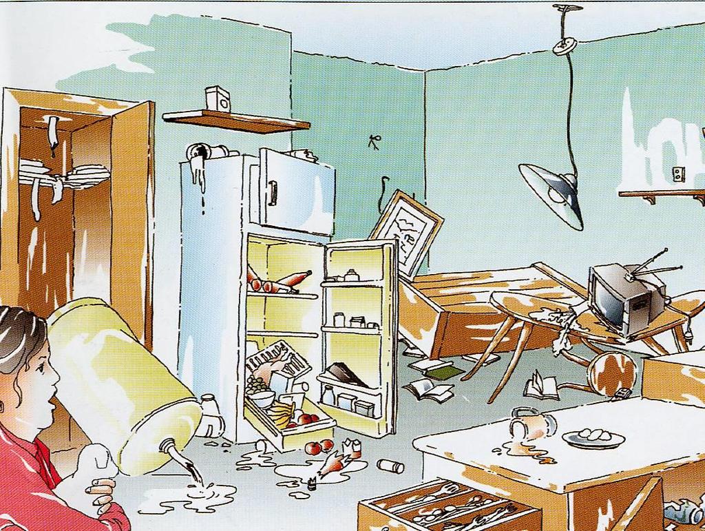
Investigation of Human Injuries during the July 26, 2003 Northern Miyagi Earthquake with Focus on Furniture Overturning
 Journal of Natural Disaster Science, Volume 28, Number 1, 2006, pp15-24 Investigation of Human Injuries during the July 26, 2003 Northern Miyagi Earthquake with Focus on Furniture Overturning Takeshi SATO
SHAKING AND GROUND FAILURE-INDUCED DAMAGE TO BUILDINGS BY THE 2010 AND 2011 CHRISTCHURCH EARTHQUAKES AND ITS LESSONS
 Int. Journal for Housing Science, Vol.36, No.3 pp.162-169, 2012 Published in the United States SHAKING AND GROUND FAILURE-INDUCED DAMAGE TO BUILDINGS BY THE 2010 AND 2011 CHRISTCHURCH EARTHQUAKES AND ITS
REIS: A spatial decision system for land valuation
 19 REIS: A spatial decision system for land valuation Himanshu Deshmukh 1, Rupali Khare 2, Kamal Pandey 1 and Dheeraj Kumar 2 1 Indian Institute of Remote Sensing, Dehradun 2 Indian School of Mines, Dhanbad
Software for Landuse Management: Modelling with GIS
 O. R. SODEINDE, Nigeria Key words: ABSTRACT Land use management has been a very important issue in the planning and maintenance of environmental and economic development of a geographic area. Therefore,
Vulnerability Mapping for Disaster Assessment Using ArcGIS Tools and Techniques for Mumbai City, India
 Vulnerability Mapping for Disaster Assessment Using ArcGIS Tools and Techniques for Mumbai City, India Reshma Raskar-Phule Assistant Professor, Department of Civil Engineering, Sardar Patel College of
PRELIMINARY STUDY OF GROUND MOTION CHARACTERISTICS IN FURUKAWA DISTRICT, JAPAN, BASED ON VERY DENSE SEISMIC-ARRAY-OBSERVATION
 Proceedings of the International Symposium on Engineering Lessons Learned from the 2011 Great East Japan Earthquake, March 1-4, 2012, Tokyo, Japan PRELIMINARY STUDY OF GROUND MOTION CHARACTERISTICS IN
DELHI URBAN RESILIENCE PROJECT
 DELHI URBAN RESILIENCE PROJECT Informed citizen-led action improves resilience of high-risk East Delhi communities Photograph SEEDS/ Siddharth Behl Source: The Indian express http//indianexpress.com/article/cities/delhi/unprepared-for-disaster-ten-of-citys-11-districts-prone-to-fires-building-collapse-looms-in-9/#sthash.vheum8rx.dpuf
Applications of GIS in Electrical Power System
 Applications of GIS in Electrical Power System Abdulrahman M. AL-Sakkaf 201102310 CRP 514 May 2013 Dr. Baqer M. AL-Ramadan Abstract GIS has been widely used in various areas and disciplines. This paper
Bridge Risk Modeling
 time good Bridge Risk Modeling Current Florida DOT Research condition bad Paul D. Thompson, Consultant Background Research team Florida State University John Sobanjo (PI) Paul D. Thompson (co-pi) Florida
Earthquake Hazards in Washoe County
 Earthquake Hazards in Washoe County Craig M. depolo Nevada Bureau of Mines and Geology Nevada Hazard Mitigation Planning Committee August 13, 2013 Earthquake Truths The consequences of damaging earthquakes
Magnitude 6.3, NORTH OF MOROCCO
 Earthquake location & overview A magnitude 6.3 earthquake struck in Alboran Sea, orth of Morocco; the epicentre was centered about 54 km ( 34 miles) E of Al Hoceima. The depth has been estimated to be
STATUS OF HAZARD MAPS VULNERABILITY ASSESSMENTS AND DIGITAL MAPS
 JapanInternational Cooperation Agency STATUS OF HAZARD MAPS VULNERABILITY ASSESSMENTS AND DIGITAL MAPS ANGUILLA REPORT THE CARIBBEAN DISASTER EMERGENCY RESPONSE AGENCY () Table of Contents Page Preface