Geographic Information Systems
|
|
|
- Jacob Russell Sullivan
- 5 years ago
- Views:
Transcription

1 Geographic Information Systems
2 What is a Geographic Information System (GIS)? definition of GIS - An internally referenced, automated, spatial information system for data mapping, management, and analysis
3 GIS Process Capture Data Register Map Base Store Data in Computer Process Data Interpret Data Display Results Convert Data to Digital Format
4 DATA FLOW IN A GIS DATA INPUT DATABASE MANAGEMENT ANALYSIS & MODELLING DATA OUTPUT
5 GIS Infra Structure HARDWARE SOFTWARE DATA (Spatial & Attribute) HUMANWARE CD_JEP
6 Seismic studies adoption of geographic information systems The GIS is a newly information systems, has received a boom in many different areas of science, such as urban planning and management of networks and other applications that rely on Atablojia Topology (flag characteristics and spatial relations), and spatial analysis Spatial Analysis.
7 Began thinking seriously about the use of GIS in disaster management and ensuring public safety since the mid-1990s past as a result of the availability of computer equipment and increasing efficiency in addition to the proliferation of civilian use of satellite imagery.

8 A demonstration of the Department of hypothetical seismic disaster in the city of Homs 1999
9 The purpose of presenting some applications in this area is the importance of the use of geographic information systems in seismic studies and access to the following conclusions.. -No need to use geographic information systems to conduct seismic studies of the area. -The geographic information systems enhance the efficiency of disaster management seismic Therefore, the adoption and application Amerham in mitigation of seismic damage and thus save lives.
10 -The use of geographic information systems requires a wide spectrum of data and schemes, but what is produced by the large amount of importance to justify the exchange of money and effort in the preparation and evaluation. -The management training seismic disaster is necessary but not sufficient to meet the real catastrophe, points should be civil defense ready to deal with the lack of information and difficulties of monitoring resources. -The geographic information systems capable of simulating the real catastrophe, and thus the first to imagine building the size of the catastrophe, and this in turn helps to monitor resources and moved.
11 - The seismic modeling of cities adopting GIS has a vital role in detecting shortcomings, which are not detectable by conventional means (taking civil defense installations, areas with high likelihood of risk...) And therefore can avoid these shortcomings before it is too late.
12 The study attributed to earthquakes using GIS الدراسة الراجعة للزلازل باستخدام GIS The study attributed contribute to the history of earthquakes that struck the region in determining seismic this region and thus help in the identification and mapping Altmentq seismic. There is more than one way to chart the road Altmentq seismic, and for example, the traditional way to assess seismic risk by going back to more than one source of seismic data as a specific reference often take 50 years and seismic intensity not less than a specific value (5.5 Richter for example) where it is being analyzed earthquakes carelessly previous earthquakes, regressive and give greater weight to the earthquakes that occurred in the earliest periods, and through the study of the likelihood of repetition, with the approval of faults and fissures neighboring relations and the use of damping are probabilistic seismic mapping.
13 Using seismic maps at the time of the construction of the facility and determination to resist the stresses resulting from the defect due to an earthquake, is the value of design expressed in the symbol of the relationship between the code Z Syrian Arab shear strength of the grassroots (V=Z.I.K.C.S.W
14 The GIS systems more flexibility in linking data and generating schemes or schemes of databases, and can be used in the generation of maps and seismic as in the following scheme that has been generated from historical records that hit Japan during the five and twenty years.

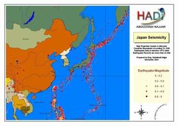
15 Seismic Japan

16 Seismic wrenches in Japan
17 Fee hotbeds of earthquakes using GIS The depth of the epicenter is the depth that extends from the Earth's surface to generate the earthquake earthquake usually described as the geographical location of its epicenter, the depth and degree of project preparation. The depth of focus of the earthquakes of less than 60 meters classified as earthquakes and a few rear of this type of earthquakes caused by the crash of the fragile rock in the earth's crust, or because the energy of rock Altchouheh generate strong internal friction largest proven aspects of the opposite of faults in the earth's crust which lead the slide plate among them, and the Gulf of Aqaba earthquake earthquakes are a few rear model.
18 Earthquakes are a few rear usually more dangerous, since the earthquake energy decreases gradually with increasing mileage, due to friction, and the depths of earthquakes give an indication of the tectonics of the area, the second figure shows that there is a link between the form of land and the depth of earthquakes
19 It is known in the science of materials that resist the sharp changes in the body that lead to greater distortions when these changes, and in seismic engineering there is similar is the role of the movement in the tectonic plates generate earthquakes, most earthquakes follow the border between tectonic plates, as shown on the latest figure, however we simply note that there is a lot of earthquakes that deviate from this rule.

20 Deep earthquakes in Japan

21 The contour of the seismic hot for Central Japan
22 Seismic world and the theory of plate tectonics

23 Modeling cities using GIS for seismic damage expected Despite all the research is still the subject of earthquakes is expected elusive now, in fact, all seeking global Alkodat used in the design of traditional civilian installations to prevent damage to components and construction-construction of the low-intensity tremors and reduce the vulnerability of the construction and non-construction level, which allows reform and restoration, in the middle of earthquakes, and prevent the total or partial collapse of high-intensity earthquakes in order to avoid loss of life.
24 Actually this should be depends on the commitment to implement design specifications demanded by Alkodat and obligation to implement the one hand and strongly earthquake occurred on the other hand, in the earthquakes, we find many important installations collapsed, although they conform to the requirements of the design code, and the reason then either permissive code in the reserves. The earthquake or simply a very strong and any business can not afford.
25 The collapse of facilities is not the only reason for the large number of human losses and material, for example, the earthquake in Kobe, Japan (January 17, 1995 at 4:25 strongly 6.2 on the Richter scale) were human losses resulted primarily from the spread of the fires that followed the earthquake and delayed control That is the sign of an earthquake is very important, but very difficult, that the disaster management is well organized and contribute to the reduction of losses; this administration must be based on information on the location of the damage and distribute and access to this information and study is difficult in the first hours after the occurrence the disaster, but the adoption of geographic information systems can create a virtual model of the expected damage caused and to update this model according to the actual data contained.
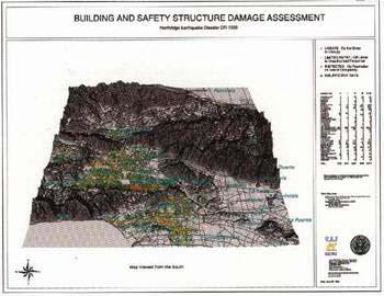
26 This model can be built by securing data in advance of the talks, installations, where we give every facility and weight depends on the extent to achieve the safety and efficiency specifications to withstand earthquake, and turning these specifications to figures associated with the specifications established as a camel resistance, soft floor, floor weak, short columns, correspondence, etc..
27 It also must be established and the location of the soil incorporation into account, such as the possibility of the occurrence of the phenomenon of volcanic soil or slide or get tons and amplify seismic energy, etc.. In addition to the lights on the impact of other factors such as high neighboring installations neighboring installations and the presence of the interval and the damage that might establish the damaged infrastructure, etc..
28 The foregoing is part of the factors which must be taken into account when the city of seismic modeling and must transform these factors to the figures depend on the proportionality (the show is given an appropriate nature of the soil incorporation from 1 to 5 for example) or based on real comparative terms (the adoption of high construction the actual value). These must be linked to the data model and three-dimension Muscat Repertory shows and installations are spatial relations themselves, as they appear activities and emergency requirements (duty firefighters and hospitals and roads...).

29 Three-dimension model of residential buildings are reflected rises, in addition to infrastructure
30 The model identifies the former scenario is a principle Altozin and sequence event, this scenario is supposed to rely on the data when the earthquake occurs (coordinates, response spectrum, depth...) Hence, road damage can be generated which are in accordance to the management of the disaster, noting updated and amended with the increasing information on the actual damages. The foregoing is a simplified explanation required an in-depth and extensive experience in the conduct of installations dynamic addition to the experience gained from previous earthquakes, and thus manufacturing model requires gentle wealth of information and takes a long time, and in spite of this, the results can be obtained on a large degree of important.
31 The planning and disaster management using GIS Geographic information systems are an effective tool in disaster management and has been used in many parts of the world in the rescue operations, firefighting and heavy floods and earthquakes and, through Dhadid Alamtheli location of the installations of Civil Defense and the Department of logistics and resource monitoring.
32

33 Such schemes theorists trilateral dimension of the patterns of the affected construction in Northeridj
34 One example of this was the Civil Defense Department systems upon Northeridj impact of the earthquake, California (January 17, 1994 at 4:31 strongly and 6.7 on the Richter scale), this may be the first real application of the adoption of seismic disaster management geographic information systems
35 used the GIS mapping of affected areas and according to the Mercali scale rate, and the areas affected shocks regressive, and in the evaluation of structural safety of buildings, also helped in the understanding of the relationship between the concentration of damaged buildings and the likelihood of a volcanic soil, and in the management of water resources and sources of drinking post the disaster, and given the privacy of the region where there are many non-english-speaking nationalities has helped GIS in monitoring human resources to help people in the affected areas
36 The use of geographic information systems vital role in the alleviation of the disaster and improve the speed of response and management of the optimum manner
REAL-TIME ASSESSMENT OF EARTHQUAKE DISASTER IN YOKOHAMA BASED ON DENSE STRONG-MOTION NETWORK
 REAL-TIME ASSESSMENT OF EARTHQUAKE DISASTER IN YOKOHAMA BASED ON DENSE STRONG-MOTION NETWORK Saburoh MIDORIKAWA 1 And Susumu ABE 2 SUMMARY This paper describes a system for REal-time Assessment of earthquake
Forces in Earth s Crust
 Name Date Class Earthquakes Section Summary Forces in Earth s Crust Guide for Reading How does stress in the crust change Earth s surface? Where are faults usually found, and why do they form? What land
Section 19.1: Forces Within Earth Section 19.2: Seismic Waves and Earth s Interior Section 19.3: Measuring and Locating.
 CH Earthquakes Section 19.1: Forces Within Earth Section 19.2: Seismic Waves and Earth s Interior Section 19.3: Measuring and Locating Earthquakes Section 19.4: Earthquakes and Society Section 19.1 Forces
Earthquakes. & Expansive Soils
 Earthquakes & Expansive Soils January 22, 2009 Plan Update Flanagan & Associates, LLC Consultants Tulsa, OK www.rdflanagan.com rdflanagan@rdflanagan.com Plan can be reviewed at: www.rdflanagan.com/.html
9.3. Earthquakes. Earthquakes at Divergent Boundaries
 9.3 Earthquakes Preview the headings on these two pages. What can you say about where earthquakes occur? As the plates that make up Earth s crust move, the rough edges lock together. Over time, pressure
Earthquakes. Earthquakes and Plate Tectonics. Earthquakes and Plate Tectonics. Chapter 6 Modern Earth Science. Modern Earth Science. Section 6.
 Earthquakes Chapter 6 Modern Earth Science Earthquakes and Plate Tectonics Section 6.1 Modern Earth Science Earthquakes and Plate Tectonics Earthquakes are the result of stresses in Earth s s lithosphere.
Trip Distribution Model for Flood Disaster Evacuation Operation
 Trip Distribution Model for Flood Disaster Evacuation Operation The devastating consequences of disasters in both developed and developing countries indicate significant lack or absence of disaster management
FOURTH GRADE HAZARDS 1 WEEK LESSON PLANS AND ACTIVITIES
 FOURTH GRADE HAZARDS 1 WEEK LESSON PLANS AND ACTIVITIES PLATE TECTONIC CYCLE OVERVIEW OF FOURTH GRADE VOLCANOES WEEK 1. PRE: Comparing different structures of volcanoes. LAB: Modeling three types of volcanoes.
Evidence for plate tectonics
 Evidence for plate tectonics See class powerpoint Printed tables 2x essay Qs markschemes Discuss/Evaluate the evidence for plate tectonics Discuss/evaluate the evidence for plate tectonics Essay: To what
Earth Science Ch. 5.1 Ch. 5 Vocabulary List Lesson 1: Earth s Moving Plates
 Earth Science Ch. 5.1 Ch. 5 Vocabulary List Lesson 1: Earth s Moving Plates Name # Teacher + 22 Use your textbook s glossary & index to help you define the following words. (2 points each) & Sketch (optional)
The Development of the Slope Failure Management System
 FANG Ji, Akiyuki KAWASAKI, Satoru SADOHARA The Development of the Slope Failure Management System There are many incidents of slope failure across Japan. The measures are required. Recently soft-measures
GIS = Geographic Information Systems;
 What is GIS GIS = Geographic Information Systems; What Information are we talking about? Information about anything that has a place (e.g. locations of features, address of people) on Earth s surface,
Damage Estimation of the Road Bridge Structure Using the Seismic Hazard map for BCM in Hokkaido, Japan
 Damage Estimation of the Road Bridge Structure Using the Seismic Hazard map for BCM in Hokkaido, Japan T. Sato & H. Nishi Civil Engineerring Research Institute for Cold Region, PWRI,Japan T. Ikeda & Y.
What Are Disasters? The Rescue Kids Trio!
 The Rescue Kids Trio! What Are Disasters? This manual was made possible through funding by the Council of Local Authorities for International Relations. Disasters and emergency preparedness Emergency preparedness
Section Forces Within Earth. 8 th Grade Earth & Space Science - Class Notes
 Section 19.1 - Forces Within Earth 8 th Grade Earth & Space Science - Class Notes Stress and Strain Stress - is the total force acting on crustal rocks per unit of area (cause) Strain deformation of materials
What causes an earthquake? Giant snakes, turtles, catfish, and spiders?
 What causes an earthquake? Giant snakes, turtles, catfish, and spiders? What causes an earthquake? The movement of Earth s plates creates enormous forces that squeeze or pull the rock in the crust as if
Pacific Catastrophe Risk Assessment And Financing Initiative
 Pacific Catastrophe Risk Assessment And Financing Initiative VANUATU September 211 Country Risk Profile: VANUATU is expected to incur, on average, 48 million USD per year in losses due to earthquakes and
UGRC 144 Science and Technology in Our Lives/Geohazards
 UGRC 144 Science and Technology in Our Lives/Geohazards Session 3 Understanding Earthquakes and Earthquake Hazards Lecturer: Dr. Patrick Asamoah Sakyi Department of Earth Science, UG Contact Information:
3D Seismic Hazard and Risk Maps for Earthquake Awareness of Citizens with Aids of GIS and Remote Sensing Technologies
 3D Seismic Hazard and Risk Maps for Earthquake Awareness of Citizens with Aids of GIS and Remote Sensing Technologies Saburoh Midorikawa Tokyo Institute of Technology In Japan, seismic hazard and risk
Preliminary Earthquake Risk Management Strategy Plan of Eskisehir, Turkey by using GIS
 Preliminary Earthquake Risk Management Strategy Plan of Eskisehir, Turkey by using GIS Metin Altan, Ferah Özturk and Can Ayday Space and Satellite Sciences Research Institute Anadolu University, TURKEY
b. Why is the area affected by each earthquake circular or nearly circular? Where is the epicenter of each quake located?
 Name: Skill Sheet 29-A Interpreting Geologic Hazard Maps Plate tectonics and the weather are often the cause of geologic hazards such as earthquakes, volcanic eruptions, and flooding. Geologic hazard events
Plate Tectonics IDEA THAT EARTH S SURFACE IS BROKEN INTO PLATES THAT MOVE AROUND. Fault = fracture in the crust where the movement has occurred
 Warm-up #14 A mountain range found 100 meters above sea level is measured to be 1,000 meters high from its tallest peak. From the top, the first 500 meters are incredibly steep. After this point, the mountain
A BASE SYSTEM FOR MICRO TRAFFIC SIMULATION USING THE GEOGRAPHICAL INFORMATION DATABASE
 A BASE SYSTEM FOR MICRO TRAFFIC SIMULATION USING THE GEOGRAPHICAL INFORMATION DATABASE Yan LI Ritsumeikan Asia Pacific University E-mail: yanli@apu.ac.jp 1 INTRODUCTION In the recent years, with the rapid
Special edition paper Development of Shinkansen Earthquake Impact Assessment System
 Development of Shinkansen Earthquake Impact Assessment System Makoto Shimamura*, Keiichi Yamamura* Assuring safety during earthquakes is a very important task for the Shinkansen because the trains operate
WHAT S CIVIL DEFENCE?
 WHAT S CIVIL DEFENCE? The Civil Protection Department was found in 1982 in order to prevent, forecast and supervise the natural disasters in agreement with regional and local governments. It also cooperates
AUTOMATED BUILDING DETECTION FROM HIGH-RESOLUTION SATELLITE IMAGE FOR UPDATING GIS BUILDING INVENTORY DATA
 13th World Conference on Earthquake Engineering Vancouver, B.C., Canada August 1-6, 2004 Paper No. 678 AUTOMATED BUILDING DETECTION FROM HIGH-RESOLUTION SATELLITE IMAGE FOR UPDATING GIS BUILDING INVENTORY
4/22/2011. Skill sharing session AVC what makes the ground tremble? What to do before. What to do during. What to do after
 Skill sharing session AVC 2011 Session Objectives what makes the ground tremble? What to do before What to do during What to do after Definition of earthquake Earthquake causes Characteristic of earthquake
DEVELOPING A TRANSPORTATION PLAN FOR EVACUATION OF BUILDUP AREAS IN CASE OF EARTHQUAKE "CASE STUDY"
 DEVELOPING A TRANSPORTATION PLAN FOR EVACUATION OF BUILDUP AREAS IN CASE OF EARTHQUAKE "CASE STUDY" Osama A. Abaza Associate Professor, Civil Engineering Dept., University of Alaska Anchorage, Anchorage,
COMPREHENSIVE GIS-BASED SOLUTION FOR ROAD BLOCKAGE DUE TO SEISMIC BUILDING COLLAPSE IN TEHRAN
 COMPREHENSIVE GIS-BASED SOLUTION FOR ROAD BLOCKAGE DUE TO SEISMIC BUILDING COLLAPSE IN TEHRAN B. Mansouri 1, R. Nourjou 2 and K.A. Hosseini 3 1 Assistant Professor, Dept. of Emergency Management, International
An entire branch of Earth science, called, is devoted to the study of earthquakes.
 Lesson One Essential Question Where do earthquakes take place? What causes earthquakes? What are three different types of faults that occur at plate boundaries? How does energy from earthquakes travels
Applications of GIS in Electrical Power System. Dr. Baqer AL-Ramadan Abdulrahman Al-Sakkaf
 Applications of GIS in Electrical Power System Dr. Baqer AL-Ramadan Abdulrahman Al-Sakkaf OUTLINES: Objective Importance of GIS GIS data development Application of GIS Findings Conclusions and Recommendations
ASSESSMENT OF TRAFFIC DISTURBANCE CONSIDERING EARTHQUAKE IN SNOW SEASON
 ASSESSMENT OF TRAFFIC DISTURBANCE CONSIDERING EARTHQUAKE IN SNOW SEASON Toshihiko MIZUTA 1 1 Associate Professor, Dept. of Civil and Environmental Engineering, Akita National College of Technology, 1-1,
GIS and Remote Sensing Support for Evacuation Analysis
 GIS and Remote Sensing Support for Evacuation Analysis Presented to GIS for Transportation Symposium Rapid City, South Dakota March 28-31, 2004 Demin Xiong Oak Ridge National Laboratory 2360 Cherahala
Processes and Impact of Natural Hazards
 The Big Island of Hawaii is the largest of the Hawaiian Islands. It is also home to a very active volcano. The Kilauea volcano has been active since 1983. The lava that flows from the Kilauea volcano has
Students will be able, using GIS, to locate the largest and most destructive earthquakes;
 Exploring Earthquake Hazards with GIS Laboratory for Introduction to Geophysics, Spring 2007 Prof. Constantin Cranganu Brooklyn College of the City University of New York Learning Objectives: Students
I. INTRODUCTION II. EARTHQUAKES
 2018 IJSRST Volume 4 Issue 5 Print ISSN: 2395-6011 Online ISSN: 2395-602X Themed Section: Science and Technology Iraq Earthquake Contour Maps Bashair A.R. Mohammed *1, Israa H. Mohammed 2, Tariq N. Ataiwe
Earthquakes Modified
 Plate Tectonics Earthquakes Modified Recall that the earth s crust is broken into large pieces called. These slowly moving plates each other, each other, or from each other. This causes much on the rocks.
Earthquakes. Chapter Test A. Multiple Choice. Write the letter of the correct answer on the line at the left.
 Earthquakes Chapter Test A Multiple Choice Write the letter of the correct answer on the line at the left. 1. Stress that pushes a mass of rock in two opposite directions is called a. shearing. b. tension.
Pacific Catastrophe Risk Assessment And Financing Initiative
 Pacific Catastrophe Risk Assessment And Financing Initiative PALAU September is expected to incur, on average,.7 million USD per year in losses due to earthquakes and tropical cyclones. In the next 5 years,
Applications of GIS in Electrical Power System
 Applications of GIS in Electrical Power System Abdulrahman M. AL-Sakkaf 201102310 CRP 514 May 2013 Dr. Baqer M. AL-Ramadan Abstract GIS has been widely used in various areas and disciplines. This paper
DISATER MANAGEMENT IN LIBRARIES
 DISATER MANAGEMENT IN LIBRARIES by S. Padmashree National Seminar cum Workshop on Trends & Challenges in LIS Education and Profession March 24 25 th 2017 Andhra University, Visakhapatnam Disaster - A
ENV208/ENV508 Applied GIS. Week 1: What is GIS?
 ENV208/ENV508 Applied GIS Week 1: What is GIS? 1 WHAT IS GIS? A GIS integrates hardware, software, and data for capturing, managing, analyzing, and displaying all forms of geographically referenced information.
A Feasibility Study about Extraction Method of Densely Crowded Areaswith Wooden Buildings in the KOBE Government. Part II 1)
") A Feasibility Study about Extraction Method of Densely Crowded Areaswith Wooden Buildings in the KOBE Government. Part II 1) Consideration of evaluation of urban fire hazard. Ritsu KATAYAMA Dept. of Architecture,
A Feasibility Study about Extraction Method of Densely Crowded Areaswith Wooden Buildings in the KOBE Government. Part II 1) Consideration of evaluation of urban fire hazard. Ritsu KATAYAMA Dept. of Architecture,
Word Cards. 2 map. 1 geographic representation. a description or portrayal of the Earth or parts of the Earth. a visual representation of an area
 Name: Date: Hour: Word Cards 1 geographic representation a description or portrayal of the Earth or parts of the Earth Example: A map is a representation of an actual location or place. 2 map a visual
Pacific Catastrophe Risk Assessment And Financing Initiative
 Pacific Catastrophe Risk Assessment And Financing Initiative TIMOR-LESTE September Timor-Leste is expected to incur, on average, 5.9 million USD per year in losses due to earthquakes and tropical cyclones.
How to Use This Presentation
 How to Use This Presentation To View the presentation as a slideshow with effects select View on the menu bar and click on Slide Show. To advance through the presentation, click the right-arrow key or
Geospatial natural disaster management
 Geospatial natural disaster management disasters happen. are you ready? Natural disasters can strike almost anywhere at any time, with no regard to a municipality s financial resources. These extraordinarily
Introduction to GIS I
 Introduction to GIS Introduction How to answer geographical questions such as follows: What is the population of a particular city? What are the characteristics of the soils in a particular land parcel?
I. Locations of Earthquakes. Announcements. Earthquakes Ch. 5. video Northridge, California earthquake, lecture on Chapter 5 Earthquakes!
 51-100-21 Environmental Geology Summer 2006 Tuesday & Thursday 6-9:20 p.m. Dr. Beyer Earthquakes Ch. 5 I. Locations of Earthquakes II. Earthquake Processes III. Effects of Earthquakes IV. Earthquake Risk
Probabilistic Seismic Hazard Maps in Dam Foundation
 Probabilistic Seismic Hazard Maps in Dam Foundation by Hideaki Kawasaki 1, Masafumi Kondo 2, Akira Nakamura 3, Kenji Inagaki 4 ABSTRACT Because Japan is one of the world s most earthquake prone countries,
GEOFOTO GROUP LTD. Buzinski prilaz 28, Zagreb, Croatia tel.: ,
 GEOFOTO GROUP LTD. Buzinski prilaz 28, 10010 Zagreb, Croatia www.geofoto-group.hr tel.: +385 91 9594 015, email: marketing@geofoto-group.hr, zvonko.biljecki@geofoto-group.hr VAT: HR63385121762, IBAN: HR1824000081110243303,
11/30/16 EARTHQUAKES ELASTIC LIMIT FAULT FORCE AND PLATES WHAT DO YOU NOTICE?
 ELASTIC LIMIT EARTHQUAKES Bend sitck but do not break it. What do you notice? No bend until it breaks. Describe the energy and forces at work. (Kinetic, potential etc) 8 TH GRADE FAULT FORCE AND PLATES
What is an Earthquake?
 Earthquakes What is an Earthquake? Earthquake - sometimes violent shaking of ground caused by movement of Earth s tectonic plates; creates seismic waves Often followed by smaller earthquakes (aftershocks);
Earthquakes = shaking of Earth because of a rapid release of energy
 There are more than 30,000 earthquakes worldwide each year! Earthquakes = shaking of Earth because of a rapid release of energy usually because of movement of tectonic plates Most earthquakes last for
THE 3D SIMULATION INFORMATION SYSTEM FOR ASSESSING THE FLOODING LOST IN KEELUNG RIVER BASIN
 THE 3D SIMULATION INFORMATION SYSTEM FOR ASSESSING THE FLOODING LOST IN KEELUNG RIVER BASIN Kuo-Chung Wen *, Tsung-Hsing Huang ** * Associate Professor, Chinese Culture University, Taipei **Master, Chinese
Earthquakes. Earthquake Magnitudes 10/1/2013. Environmental Geology Chapter 8 Earthquakes and Related Phenomena
 Environmental Geology Chapter 8 Earthquakes and Related Phenomena Fall 2013 Northridge 1994 Kobe 1995 Mexico City 1985 China 2008 Earthquakes Earthquake Magnitudes Earthquake Magnitudes Richter Magnitude
Source:
 Source: http://www.pastforward.ca/perspectives/columns/10_02_05.htm At 16:53, on Wednesday, January 12th, 2010, a devastating 7.0 earthquake struck Haiti's capital, Port-au-Prince. The earthquake left
2.3 Notes: Earthquake Damage Can Be Reduced
 2.3 Notes: Earthquake Damage Can Be Reduced Earthquakes can cause severe damage and loss of life Each year, there is about one earthquake with a magnitude of or higher-this is an extremely earthquake.
I. What are Earthquakes?
 I. What are Earthquakes? A. There is more to earthquakes than just the shaking of the ground. An entire branch of Earth science, called seismology, is devoted to the study of earthquakes. B. Earthquakes
SEISMIC RISK ASSESSMENT IN ARMENIA
 SEISMIC RISK ASSESSMENT IN ARMENIA Hovhannes Khangeldyan Head of National Crisis Management Center Rescue Service Ministry of Emergency Situations of the Republic of Armenia Tokyo, 2016 ARMENIA: GEOGRAPHICAL
Earthquakes Science & Safety. Ms Joan L. Latchman Seismologist Seismic Research Unit
 Earthquakes Science & Safety Ms Joan L. Latchman Seismologist Seismic Research Unit Summary Trinidad lies in an area of high earthquake activity for the Caribbean. Earthquake safety tips should be practiced
Guidelines for Site-Specific Seismic Hazard Reports for Essential and Hazardous Facilities and Major and Special-Occupancy Structures in Oregon
 Guidelines for Site-Specific Seismic Hazard Reports for Essential and Hazardous Facilities and Major and Special-Occupancy Structures in Oregon By the Oregon Board of Geologist Examiners and the Oregon
DATA UPDATING METHODS FOR SPATIAL DATA INFRASTRUCTURE THAT MAINTAIN INFRASTRUCTURE QUALITY AND ENABLE ITS SUSTAINABLE OPERATION
 DATA UPDATING METHODS FOR SPATIAL DATA INFRASTRUCTURE THAT MAINTAIN INFRASTRUCTURE QUALITY AND ENABLE ITS SUSTAINABLE OPERATION Saya Murakami *, Takashi Takemoto, Yutaka Ito Kokusai Kogyo Co., Ltd, 2-24-1
Tectonic Processes and Hazards Enquiry Question 1: Why are some locations more at risk from tectonic hazards?
 Tectonic Processes and Hazards Enquiry Question 1: Why are some locations more at risk from tectonic hazards? Key words Basalt Andesite Rhyolite Benioff Zone Subduction zone Crustal fracturing Definition
PROTECTING MONUMENTS AND HISTORICAL SETTINGS FROM THE NEXT EARTHQUAKE
 PROTECTING MONUMENTS AND HISTORICAL SETTINGS FROM THE NEXT EARTHQUAKE R.PAPADHMHTRIOU, L.PELLI EUROPEAN CENTER OF PREVENTING & FORECASTING OF EARTHQUAKES Confronting the problem SEISMIC RISK R SEISMIC
Use of Geospatial data for disaster managements
 Use of Geospatial data for disaster managements Source: http://alertsystemsgroup.com Instructor : Professor Dr. Yuji Murayama Teaching Assistant : Manjula Ranagalage What is GIS? A powerful set of tools
Enhance Security, Safety and Efficiency With Geospatial Visualization
 Areas within 10 minutes of an exit are emphasized on this map, to give an indication of how accessible neighborhoods are by highway. The colors represent 1, 3, 5 and 10 minute increments from the exits.
INTRODUCTION TO EARTHQUAKES
 INTRODUCTION TO EARTHQUAKES Seismology = Study of earthquakes Seismologists = Scientists who study earthquakes Earthquake = Trembling or shaking of the earth s surface, usually as a result of the movement
Seismic vulnerability in Latinamerica Speaker: Rafael Osiris de León Sciences Academy of Dominican Republic.
 Seismic vulnerability in Latinamerica Speaker: Rafael Osiris de León Sciences Academy of Dominican Republic. IANAS GENERAL ASSEMBLY Punta Cana, 16-20 July, 2013 TECTONIC PLATES AND EARTHQUAKES Pacific
Earthquakes & Volcanoes
 Earthquakes & Volcanoes Geology - the study of solid Earth, the rocks of which it is composed, and the processes by which they change geo = Earth; ology = study of Earth s Layers Plate Tectonics - the
Perception of Earthquake Risk and Postdisaster
 Perception of Earthquake Risk and Postdisaster Reconstruction: Comparative Study of Two Residential Neighborhoods on Different Socio-economic Status in Tehran Seyed Ali Badri University of Tehran, sabadri@ut.ac.ir
The UN-GGIM: Europe core data initiative to encourage Geographic information supporting Sustainable Development Goals Dominique Laurent, France
 INSPIRE conference Strasbourg 6 September 2017 The UN-GGIM: Europe core data initiative to encourage Geographic information supporting Sustainable Development Goals Dominique Laurent, France Introduction
USING 3D GIS TO ASSESS ENVIRONMENTAL FLOOD HAZARDS IN MINA
 King Fahd University of Petroleum & Minerals College of Environmental Design Geographical Information system USING 3D GIS TO ASSESS ENVIRONMENTAL FLOOD HAZARDS IN MINA Prepared by : Ali AL-Zahrani OUTLINE
Name Date Class. radiate in all directions, carrying some of the. of plate boundaries have different usual patterns of.
 Chapter Outline Earthquakes CHAPTER 6 Lesson 1: Earthquakes and Plate Boundaries A. What is an earthquake? 1. A(n) is the rupture and sudden movement of rocks along a fault. A fault is a fracture surface
Pacific Catastrophe Risk Assessment And Financing Initiative
 Pacific Catastrophe Risk Assessment And Financing Initiative TUVALU is expected to incur, on average,. million USD per year in losses due to earthquakes and tropical cyclones. In the next 5 years, has
Earth and Space Science Semester 2 Exam Review. Part 1. - Convection currents circulate in the Asthenosphere located in the Upper Mantle.
 Earth and Space Science 2015 Semester 2 Exam Review Part 1 Convection -A form of heat transfer. - Convection currents circulate in the Asthenosphere located in the Upper Mantle. - Source of heat is from
Dangerous tsunami threat off U.S. West Coast
 Earthquakes Ch. 12 Dangerous tsunami threat off U.S. West Coast Earthquakes What is an Earthquake? It s the shaking and trembling of the Earth s crust due to plate movement. The plates move, rocks along
Need of Proper Development in Hilly Urban Areas to Avoid
 Need of Proper Development in Hilly Urban Areas to Avoid Landslide Hazard Dr. Arvind Phukan, P.E. Cosultant/Former Professor of Civil Engineering University of Alaska, Anchorage, USA RI District Governor
Disaster Risk Reduction in Survey for Seismic Protection of MES
 Survey for Seismic Protection Ministry of Emergency Situations of Republic of Armenia Disaster Risk Reduction in Survey for Seismic Protection of MES Syuzanna Kakoyan Leading specialist at the Department
Cascadia megathrust earthquakes: reducing risk through science, engineering, and planning
 Cascadia megathrust earthquakes: reducing risk through science, engineering, and planning NSF Hazards SEES EAR-1331412 Urban Science and Engineering Workshop 21 July 2014 Everything to do with M9 Cascadia
Initiative. Country Risk Profile: papua new guinea. Better Risk Information for Smarter Investments PAPUA NEW GUINEA.
 Pacific Catastrophe Risk Assessment And Financing Initiative PAPUA NEW GUINEA September 211 Country Risk Profile: papua new is expected to incur, on average, 85 million USD per year in losses due to earthquakes
DOWNLOAD OR READ : GIS BASED FLOOD LOSS ESTIMATION MODELING IN JAPAN PDF EBOOK EPUB MOBI
 DOWNLOAD OR READ : GIS BASED FLOOD LOSS ESTIMATION MODELING IN JAPAN PDF EBOOK EPUB MOBI Page 1 Page 2 gis based flood loss estimation modeling in japan gis based flood loss pdf gis based flood loss estimation
Seismic Hazard Switzerland. When, where, and how often does certain shaking occur in Switzerland?
 Seismic Hazard Switzerland When, where, and how often does certain shaking occur in Switzerland? Hazard The hazard map shows where and how often certain incidents of horizontal acceleration are likely.
CLICK HERE TO KNOW MORE
 CLICK HERE TO KNOW MORE GENERALIZATION OF TOPOGRAPHIC DATABASE FOR SERVING GEOSPATIAL DATA FOR MILITARY AND SOCIO-ECONOMIC TASKS IN VIETNAM Speaker: Lieutenant Colonel, Nguyen Dinh Minh GENERAL STAFF -
Estimation of Damage Ratios of Wooden Houses and Water Distribution Pipelines in an Earthquake Scenario for the Tokyo Metropolitan Region
 The 2011 World Congress on Advances in Structural Engineering and Mechanics (ASEM'11 + ) Seoul, Korea, 18-22 September, 2011 Estimation of Damage Ratios of Wooden Houses and Water Distribution Pipelines
Directed Reading. Section: How and Where Earthquakes Happen WHY EARTHQUAKES HAPPEN. Skills Worksheet. 1. Define earthquake.
 Skills Worksheet Directed Reading Section: How and Where Earthquakes Happen 1. Define earthquake. 2. When do earthquakes usually occur? 3. What is a fault? WHY EARTHQUAKES HAPPEN 4. Rocks along both sides
4 Deforming the Earth s Crust
 CHAPTER 7 4 Deforming the Earth s Crust SECTION Plate Tectonics BEFORE YOU READ After you read this section, you should be able to answer these questions: What happens when rock is placed under stress?
Special feature: Are its lessons being adequately applied? Follow-up on the ten-year anniversary of the Hanshin-Awaji Earthquake
 Special feature: Are its lessons being adequately applied? Follow-up on the ten-year anniversary of the Hanshin-Awaji Earthquake - Are we prepared for future massive earthquakes? - Hisakazu SAKAI Member
Identifying the causes and effects of earthquakes
 Science 3 Physical Earth and Space Life LESSON 57 Identifying the causes and effects of earthquakes Lesson Preparation Program Materials Child s Booklet E Exploring the Earth s Structure (pp. 12 13) Optional:
Purpose of the seminar
 Earthquake disaster preparedness June 24, 2008 Koshun Yamaoka Research Center for Seismology, Volcanology and Disaster Mitigation Graduate School of Environmental Studies Nagoya University Purpose of the
Qatar s Nation-Wide GIS Cooperation on Local and Regional Levels
 Qatar s Nation-Wide GIS Cooperation on Local and Regional Levels Dr. Mohammad Abd El-Wahab Hamouda GIS Consultant & Chairman of GIS Coordinators Group The Center for GIS State of Qatar Second High Level
21. Earthquakes I (p ; 306)
") 21. Earthquakes I (p. 296-303; 306) How many people have been killed by earthquakes in the last 4,000 years? How many people have been killed by earthquakes in the past century? What two recent earthquakes
21. Earthquakes I (p. 296-303; 306) How many people have been killed by earthquakes in the last 4,000 years? How many people have been killed by earthquakes in the past century? What two recent earthquakes
Natural Hazards Mitigation in Iceland
 Natural Hazards Mitigation in Iceland With special emphasis on earthquake risk Júlíus Sólnes Professor of civil and environmental engineering Dept. of engineering, University of Iceland Cambridge, 19th
Baldwin County, Alabama
 2015 Baldwin County, Alabama Multi-Hazard Mitigation Plan I. Comprehensive Plan A multi-jurisdiction plan City of Bay Minette City of Daphne Town of Elberta City of Fairhope City of Foley City of Gulf
APPLICATIONS OF EARTHQUAKE HAZARD MAPS TO LAND-USE AND EMERGENCY PLANNING EXAMPLES FROM THE PORTLAND AREA
 APPLICATIONS OF EARTHQUAKE HAZARD MAPS TO LAND-USE AND EMERGENCY PLANNING EXAMPLES FROM THE PORTLAND AREA O. Gerald Uba Metro, Portland, Oregon OVERVIEW The extent to which we understand "below ground"
To estimate damage ratios of water and gas distribution pipes, fragility curves were empirically obtained based on damage datasets after the 1995 Kobe
 Proceedings of the 9th U.S. National and 10th Canadian Conference on Earthquake Engineering Compte Rendu de la 9ième Conférence Nationale Américaine et 10ième Conférence Canadienne de Génie Parasismique
Name: KEY California Geology. Unit IX Earthquakes
 Unit IX Earthquakes Name: KEY California Geology The following assignment is based on information presented in Unit IX. Be sure to read the paragraphs (Note 1) provided before you attempt to answer the
Earthquakes. Forces Within Eartth. Faults form when the forces acting on rock exceed the rock s strength.
 Earthquakes Vocabulary: Stress Strain Elastic Deformation Plastic Deformation Fault Seismic Wave Primary Wave Secondary Wave Focus Epicenter Define stress and strain as they apply to rocks. Distinguish
Seismic Hazard Abatement Program
 Seismic Hazard Abatement Program Recommendations To take the first steps toward a seismic mitigation program for older existing buildings To improve our current regulatory system for implementation of
Applications on Slope Land Management through GIS Technology
 Applications on Slope Land Management through GIS Technology Hsiu-Yi Ko, Jo-Yu Liu,Tai-Chung Hsiao, Tian-Ying Chou, Ying-Hui Chang Geographic Information Systems Research Center of Feng Chia University