GRS Capita Selecta GIS in practice. Urban remote sensing at an international research institute. Dr. Wieke Heldens, MSc
|
|
|
- Denis Mitchell
- 5 years ago
- Views:
Transcription

1 GRS Capita Selecta GIS in practice Urban remote sensing at an international research institute Dr. Wieke Heldens, MSc
2 Content From MGI student to scientist at DLR Remote sensing research as daily work Ideas about the future of GIS and remote sensing
3 From MGI student to scientist at DLR
4 CV Bsc Landscape, planning and design (WUR) Msc Geo-information Science (WUR) Phd Geography, University of Würzburg, Germany 06 Scientific staff, DLR 09 now
5 MGI 04/05 & 05/06 Remote Sensing Geo-information Tools Data Management SDI Spatial modelling Academic Master Cluster Planning Theory Quantitative analysis of land use systems Internship at DLR: imaging spectroscopy Thesis: Spatio-temporal modelling of land cover using Markov theory
6 Current work DLR Earth Observation Center, Dpt. Land Surface Team: Urban areas and land management Design, implementation and demonstration of remote sensing products Operational processing techniques in the context of urban remote sensing
7 Remote sensing research at DLR DLR and the department Land Surface Urban remote sensing research

 employees in Oberpfaffenhofen Offices in")

8 DLR in Germany R&D in Aeronautics, Space, Energy, Transportation, Civil Security At research institutes and facilities at 13 sites With employees (incl. scientific staff, 0 PhD) employees in Oberpfaffenhofen Offices in Brüssel, Paris and Washington Hamburg Bremen Trauen Berlin Braunschweig Dortmund Goettingen Koeln Bonn Neustrelitz Lampoldshausen Stuttgart Weilheim Oberpfaffenhofen DLR site

9

10 The Earth Observation Center (EOC) DFD & IMF Core of DLR s remote sensing activities ca. 3 employees working in 2 research institutes and 12 departments at 3 sites ca. employees working in 2 University Departments ca. 2 scientists from more than nations ca. PhD students ca. guest scientists ca. 45% third party funding
 Land Suface and Global Change Geo-")


11 Three Research Departments at DFD ( staff) Land Suface and Global Change Geo- and biophysical parameters Ecological and Urban mapping Dynamics and Change Detection Civil Crisis Information and Georisks Rapid mapping and early warning Crisis Information Systems Vulnerability and Risk Assessments Atmosphere Climate signal detection in the mesosphere Trace Gases and Aerosols for Air quality and Health applications Solar and bio energy Scientific Geovisualisation Animations Envisioning Science


12 Dpt. Land Surface Applications Allianz Arena Land Surface Processes and Interaction Net primary production imperviousness Englischer Garten Urban Areas and Managed Land Natural Ressources Management soil organic carbon
13 Land Surface Applications: methodology development Monitoring Tools Thematic Processor Development Time Series/ Trend Analysis Global Urban Footprint Twinned object and pixel based classification Change Detection Environmental Information Systems ELVIS Information Extraction SAR Technologies Polarimetry Operational SAR Geocoding Quality Control Atm. Correction Vicarious Calibration Spectral/(spatial) Mixture Analysis Spectroscopy Enhanced Pre-Processing

14 German EO Missions TerraSAR-X and TanDEM-X TerraSAR-X in operation since June 07 Bi-static formation flight with TanDEM-X since October Mission operations and scientific exploitation by DLR institutes in Oberpfaffenhofen Commercial data distribution: Astrium/Infoterra GmbH


15 Tien Shan, China T12:39:09


16 Mission Principle Environmental Mapping and Analysis Program Launch: 17 Spatial Res.: Repetition: m at km swath 5 days at +/- off-nadir DLR Satellite, Principle investigator: GFZ Hyperspectral instrument, >0 channels (4 24 nm) Platform for further operationalization of methods for information retrieval for land surface monitoring
17 Geo-privacy and ethical issues Geo-privacy Usually special conditions for science Use of high res. satellite data of certain missions SatDSiG German Satellity Data Safety Law Cooperation with non-research parties an their data Census data Cadastral data Copyright issues Data Programming code Results Open Access / Open source No ethical issues until now


18 Team: urban areas and land management Global urban footprint Urban micro climate modelling

19 Urban micro climate modelling envi-met - Bruse & Fleer (1998): Simulating surface-plant-air interactions inside urban environments with a three dimensional numerical model. Environmental Modelling and Software, 13,
20 Urban micro climate modelling Input parameters Buildings Vegetation Non-built surfaces Weather conditions Location Roof material (14 different materials) Height Material properties: albedo Material properties: thermal inertia Location Type (deciduous, coniferous, grass) Height Leaf area density (related to leaf area index) Reflectance properties (albedo) Photosynthetic and evapotranspiration properties Location Type (impervious, pervious) Reflectance properties (albedo) Soil properties (hydrological) Temperature Wind speed Date, sun dawn, sun set Color legend HyMap hyperspectral data HRCS height data Literature Weather station or scenario variable
 Recording dates: 17 + 25 June 07 Pre-processing: Atmospheric")

21 Urban micro climate modelling Airborne sensor HyMap 4 m² pixel size µm (125 bands) Recording dates: June 07 Pre-processing: Atmospheric correction Geometric correction HRSC Stereo camera Accuracy: X,Y: 1 m; Z: 0.1 m Recording date:15 September 04 DEM preparation by DLR Berlin Pre-processing: DEM normalization RGB: SWIR, NIR, RED

22 Urban micro climate modelling
 Temperature of atmosphere 287 K Biometeorology boundary parameters")
23 Urban micro climate modelling 24 hours simulation time Start: 03:00 output time interval: minutes Initial values for Wind speed 3.5 m/s Wind direction 245 Humidity % (rel. Humidity in 2 m) Temperature of atmosphere 287 K Biometeorology boundary parameters

 Flow v 95.00 % 0. m/s 0.")
 1 1 0 0 0 X (m) Flow v 0. m/s 0. m/s x/y cut at z= 3 01 2.00 [??] 3.00 [??] 1 4.00 [??].00 % 5.00 [??].00 % 6.00 [??] 95.00 % 7.00 [??] 75.00 % Flow v 0. m/s 0. m/s 0. m/s 0. m/s 0. m/s 0. m/s 0. m/s 1.")
24 Pot. Temperature 2. K Urban micro climate modelling K 291. K K Y (m) 292. K subset 14okt09 15:00: Temperature & wind Humidity x/y cut at z= Pot. Temperature subset 14okt09 15:00: K x/y cut at z= 3 x/y cut at z= K 293. K K % 0. m/s.00 % m/s % % 0. m/s % 294. K.00 % K x/y cut at z= % Y (m) PMV Value % K Y (m) Y (m) 1 Flow v.00 % K 294. K K subset okt09 15: Relative Humidity K 291. K 293. K subset 14okt09 15:00: K Regular block development K Predicted Mean Vote (PMV) Flow v % 0. m/s 0. m/s Flow v 0. m/s 0. m/s 0. m/s 0. m/s 0. m/s 0. m/s <Left foot> 0 X (m) <Left foot> 0 Row house development 01 X (m) Pot. Temperature <Left foot> <Right foot> K X (m) X (m) Flow v 0. m/s 0. m/s x/y cut at z= [??] 3.00 [??] [??].00 % 5.00 [??].00 % 6.00 [??] % 7.00 [??] % Flow v 0. m/s 0. m/s 0. m/s 0. m/s 0. m/s 0. m/s 0. m/s 1.00 m/s 1.00 m/s.00 % % subset1 28sept 09 15:00: subset1 28sept 09 15:00: x/y cut at z= 3 x/y cut at z= 3.00 % % N X (m) Pot. Temperature 1 0 N 1 <Right foot>.00 % K K 293. K K Flow v PMV Value.00 % % % % % % K 0. m/s m/s m/s m/s % 294. K <Right foot> 0. m/s PMV Value % 292. K X (m) <Left foot> K Relative Humidity <Right foot> Y (m) x/y% cut at z= [??] 0. m/s 291. K Y (m) 0.00 [??] % 2. K <Right foot> [??] 0 PMV Value 1 subset sept 09 15: % %N <Right foot> Flow v 0. m/s subset1 28sept 09 15:00: % [??].00 % <Left foot> N <Left foot> 1.00 % 1.00 m/s % K % 0. m/s K.00 % K 294. K <Left foot> Dense block development % 292. K Y (m) Y (m) 1 X (m).00 % K N Relative Humidity K Y (m) 0 Y (m) Y (m) x/y cut at z= 3 N K 0 subset 13 19okt09 15:00: Relative Humidity x/y cut at z= K 1.00 m/s subset 13 19okt09 15:00: x/y cut at z= 3 0. m/s 1.00 m/s subset 13 19okt09 15:00: N 0. m/s 0. m/s 1.00 m/s 1.00 m/s 0. m/s Flow v 0. m/s Flow v % 0. m/s Y (m) Flow v 0. m/s Flow v 0. m/s 0. m/s 0. m/s 0. m/s 0. m/s 0. m/s 1.00 m/s 1.00 m/s 3.00 N <Left foot> X (m) <Left foot> Flow v N m/s 1.00 m/s m/s 0. m/s 0. m/s X (m) <Right foot> <Left foot> 01 X (m) <Right foot> 1 N 0. m/s 0. m/s 0. m/s <Right foot> N


25 Glob Cover 09 Google Earth Global Urban Footprint Accra Dar es Salaam Baghdad Amsterdam 0 m resolution


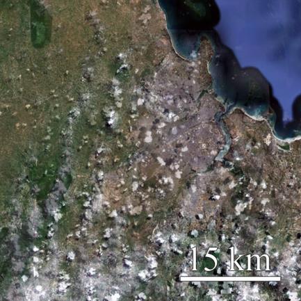

26 Global Urban Footprint Accra Dar es Salaam Baghdad Amsterdam Global Urban Footprint Google Earth 12 m (resp. 75 m) resolution


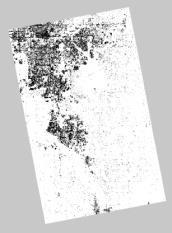


27 TanDEM-X Mission Urban Footprint Processor Ground segment Urban Footprint Mosaick classification Mosaicking and post-processing Amplitude (degr.) Texture Urban Footprint Production environment Feature extraction W42 Data base Reference and aux. data DEM


28 Global Urban Footprint Den Helder original backscattering amplitude extracted speckle divergence Urban Footprint

29 Global Urban Footprint Japan: ~0 images original extracted Global backscattering Urban speckle Footprint divergence amplitude

30 Global Urban Footprint Tokio 0 25 Kilometers Global Urban Modis Footprint 0 m 12 m Urban No urban
31 Ideas about the future of GIS and remote sensing
32 Research directions Remote sensing research: Sentinel Satellites: large amount of (free) satellite data Time series analysis Automated processing & processing chains Applied remote sensing Combining RS with secondairy data (statistical, meteorological, census) Decision support system General Programming (C\C++, Python, Java, IDL, ) is important Knowledge about the application also!


33 Urban growth Istanbul


 data + Global")
34 Urban Growth Manila Urban spatio-temporal development based on historical optical (Landsat MSS, TM and ETM+) and SAR (ERS, ASAR) data + Global Urban Footprint.
35 Thank you for your attention!
Urban Mapping & Change Detection. Sebastian van der Linden Humboldt-Universität zu Berlin, Germany
 Urban Mapping & Change Detection Sebastian van der Linden Humboldt-Universität zu Berlin, Germany Introduction - The urban millennium Source: United Nations Introduction Text Source: Google Earth Introduction
German Remote Sensing Data Center (DFD) of DLR Department on Environment and Security. Training Course. Introduction to Geospatial Data Analysis
 of DLR Department on Environment and Security. Training Course. Introduction to Geospatial Data Analysis") Training Course Introduction to Geospatial Data Analysis 11-15 February 2008, NAM Center, Jakarta German Aerospace Center - DLR Information about the German Aerospace Center (DLR) DLR is Germany s national
Training Course Introduction to Geospatial Data Analysis 11-15 February 2008, NAM Center, Jakarta German Aerospace Center - DLR Information about the German Aerospace Center (DLR) DLR is Germany s national
Monitoring Land Cover and Land Use in Central Asia Remote Sensing Contributions from selected German projects
 Monitoring Land Cover and Land Use in Central Asia Remote Sensing Contributions from selected German projects NASA LCLUC Meeting, Tashkent, 11.-13.11.2013 Christopher Conrad University of Würzburg, Institute
Institute of Optical Sensor Systems German Aerospace Center
 DLR.de Chart 1 Institute of Optical Sensor Systems German Aerospace Center Dr. Anko Börner Institute of Optical Sensor Systems 15th February 2017 DLR.de Chart 2 DLR Deutsches Zentrum für Luft- und Raumfahrt
URBAN MAPPING AND CHANGE DETECTION
 URBAN MAPPING AND CHANGE DETECTION Sebastian van der Linden with contributions from Akpona Okujeni Humboldt-Unveristät zu Berlin, Germany Introduction Introduction The urban millennium Source: United Nations,
Urban Mapping. Sebastian van der Linden, Akpona Okujeni, Franz Schug 11/09/2018
 Urban Mapping Sebastian van der Linden, Akpona Okujeni, Franz Schug 11/09/2018 Introduction to urban remote sensing Introduction The urban millennium Source: United Nations, 2014 Urban areas mark extremes
TerraSAR-X and TanDEM-X Applications for Maritime Domain Awereness
 TerraSAR-X and TanDEM-X Applications for Maritime Domain Awereness Dr. Stephan Brusch German Aerospace Center DLR Remote Sensing Technology Institute DLR Oberpfaffenhofen (Germany) Dr. Jürgen Drescher
Time Series Analysis with SAR & Optical Satellite Data
 Time Series Analysis with SAR & Optical Satellite Data Thomas Bahr ESRI European User Conference Thursday October 2015 harris.com Motivation Changes in land surface characteristics mirror a multitude of
Towards eenvironment Prague, March GMES Space Component. Josef Aschbacher Head, ESA GMES Space Office
 Towards eenvironment Prague, 25-27 March 2009 GMES Space Component Josef Aschbacher Head, ESA GMES Space Office Prague from Space Segment 2 05 Nov 2003 CNES 2003 GISAT 2007 ESA GSELAND GMES is an EU led
EXPLORING THE DEMANDS ON HYPERSPECTRAL DATA PRODUCTS FOR URBAN PLANNING: A CASE STUDY IN THE MUNICH REGION
 EXPLORING THE DEMANDS ON HYPERSPECTRAL DATA PRODUCTS FOR URBAN PLANNING: A CASE STUDY IN THE MUNICH REGION W.Heldens 1, T. Esch 2, U. Heiden 2, A. Müller 2 and S. Dech 1,2 1 Department of Remote Sensing,
German Contributions to Earth Observation from Space WMO ET-SAT #11
 German Contributions to Earth Observation from Space Update @ WMO ET-SAT #11 Albrecht von Bargen DLR Space Administration Earth Observation Geneve (CH), April 4-6, 2017 DLR the German Aerospace Center
Land Cover and Asset Mapping Operational Change Detection
 Land Cover and Asset Mapping Operational Change Detection Andreas Müller DLR DFD with the support of Charly Kaufmann, Allan Nielsen, Juliane Huth ESA Oil & Gas Workshop, 13-14 September 2010 Folie 1 TWOPAC
Overview of Remote Sensing in Natural Resources Mapping
 Overview of Remote Sensing in Natural Resources Mapping What is remote sensing? Why remote sensing? Examples of remote sensing in natural resources mapping Class goals What is Remote Sensing A remote sensing
Monitoring daily evapotranspiration in the Alps exploiting Sentinel-2 and meteorological data
 Monitoring daily evapotranspiration in the Alps exploiting Sentinel-2 and meteorological data M. Castelli, S. Asam, A. Jacob, M. Zebisch, and C. Notarnicola Institute for Earth Observation, Eurac Research,
Long-Term Time Series of Water Vapour Total Columns from GOME, SCIAMACHY and GOME-2
 Graphics: ESA Graphics: ESA Graphics: ESA Long-Term Time Series of Water Vapour Total Columns from GOME, SCIAMACHY and GOME-2 S. Noël, S. Mieruch, H. Bovensmann, J. P. Burrows Institute of Environmental
Remote Sensing and EO activities at the University of Turku
 Remote Sensing and EO activities at the University of Turku Niina Käyhkö Associate Professor Department of Geography and Geology GEO meeting/syke May 23rd, 2018 Geospatial competence at the University
Estimation of Wavelet Based Spatially Enhanced Evapotranspiration Using Energy Balance Approach
 Estimation of Wavelet Based Spatially Enhanced Evapotranspiration Using Energy Balance Approach Dr.Gowri 1 Dr.Thirumalaivasan 2 1 Associate Professor, Jerusalem College of Engineering, Department of Civil
GIS and Remote Sensing
 Spring School Land use and the vulnerability of socio-ecosystems to climate change: remote sensing and modelling techniques GIS and Remote Sensing Katerina Tzavella Project Researcher PhD candidate Technology
AUTOMATISIERTE ZEITREIHENANALYSE VON FERNERKUNDUNGSDATEN FÜR DAS MONITORING VON OBERFLÄCHENGEWÄSSERN
 Place image here (10 x 3.5 ) AUTOMATISIERTE ZEITREIHENANALYSE VON FERNERKUNDUNGSDATEN FÜR DAS MONITORING VON OBERFLÄCHENGEWÄSSERN THOMAS BAHR & NICOLAI HOLZER 23. Workshop Arbeitskreis Umweltinformationssysteme
Preparation of LULC map from GE images for GIS based Urban Hydrological Modeling
 International Conference on Modeling Tools for Sustainable Water Resources Management Department of Civil Engineering, Indian Institute of Technology Hyderabad: 28-29 December 2014 Abstract Preparation
Themes for Geomatics Conference. Geodesy Themes
 Themes for Geomatics Conference Geodesy Themes Geodynamics o Modeling the Deformation of the Earth s Crust o Recent Advances in Geometric Approaches to Deformation Analysis o Monitoring Systems (Sensors
A1 - Total Land Use by Mining and Milling topographical footprint
 A. LAND-USE A1 - Total Land Use by Mining and Milling topographical footprint Topographical Footprint: The total areal footprint (2-dimensional) used by the mine/mill is an overarching proxy for a variety
AN OBJECT-BASED CLASSIFICATION PROCEDURE FOR THE DERIVATION OF BROAD LAND COVER CLASSES USING OPTICAL AND SAR DATA
 AN OBJECT-BASED CLASSIFICATION PROCEDURE FOR THE DERIVATION OF BROAD LAND COVER CLASSES USING OPTICAL AND SAR DATA T. RIEDEL, C. THIEL, C. SCHMULLIUS Friedrich-Schiller-University Jena, Earth Observation,
Remote Sensing I: Basics
 Remote Sensing I: Basics Kelly M. Brunt Earth System Science Interdisciplinary Center, University of Maryland Cryospheric Science Laboratory, Goddard Space Flight Center kelly.m.brunt@nasa.gov (Based on
ESM 186 Environmental Remote Sensing and ESM 186 Lab Syllabus Winter 2012
 ESM 186 Environmental Remote Sensing and ESM 186 Lab Syllabus Winter 2012 Instructor: Susan Ustin (slustin@ucdavis.edu) Phone: 752-0621 Office: 233 Veihmeyer Hall and 115A, the Barn Office Hours: Tuesday
Status of ESA EO Programmes
 Status of ESA EO Programmes 54 th ESSC Plenary Meeting 24 November 2017 Maurice Borgeaud, ESA Head of the ESA Earth Observation Science, Applications and Climate Department Issue/Revision: 0.0 Reference:
The Potential of High Resolution Satellite Interferometry for Monitoring Enhanced Oil Recovery
 The Potential of High Resolution Satellite Interferometry for Monitoring Enhanced Oil Recovery Urs Wegmüller a Lutz Petrat b Karsten Zimmermann c Issa al Quseimi d 1 Introduction Over the last years land
Polar Multi-Sensor Aerosol Product: User Requirements
 Polar Multi-Sensor Aerosol Product: User Requirements Doc.No. Issue : : EUM/TSS/REQ/13/688040 v2 EUMETSAT EUMETSAT Allee 1, D-64295 Darmstadt, Germany Tel: +49 6151 807-7 Fax: +49 6151 807 555 Telex: 419
Updates on CMA FENGYUN Meteorological Satellite Programs
 Updates on CMA FENGYUN Meteorological Satellite Programs Peng ZHANG National Satellite Meteorological Center, China Meteorological Administration (NSMC/CMA) 29 Nov. - 5 Dec. 2017, Darmstadt, Germany 1.
The VENμS mission: Earth Observation with High Spatial and Temporal Resolution Capabilities
 Ben Gurion University The VENμS mission: Earth Observation with High Spatial and Temporal Resolution Capabilities G. Dedieu 1, O. Hagolle 2, A. Karnieli 3, S. Cherchali 2 P. Ferrier 2 and Y. Yaniv 4 1
Near Real Time Applications for Maritime Situational Awareness
 Near Real Time Applications for Maritime Situational Awareness Egbert Schwarz Maritime Security Lab Neustrelitz (DFD) ATLAS MEETS SCIENCE Bremen, 12.-13. October 2016 Presentation Outline Background Earth
GMES Initial Operations- Network for Earth Observation Research and Training
 GMES Initial Operations- Network for Earth Observation Research and Training Sybrand van Beijma, Dr. Virginia Nicolás-Perea, Prof. Heiko Balzter Centre for Landscape and Climate Research, University of
Spectral surface albedo derived from GOME-2/Metop measurements
 Spectral surface albedo derived from GOME-2/Metop measurements Bringfried Pflug* a, Diego Loyola b a DLR, Remote Sensing Technology Institute, Rutherfordstr. 2, 12489 Berlin, Germany; b DLR, Remote Sensing
A Facility for Producing Consistent Remotely Sensed Biophysical Data Products of Australia
 TERRESTRIAL ECOSYSTEM RESEARCH NETWORK - AusCover - A Facility for Producing Consistent Remotely Sensed Biophysical Data Products of Australia June, 2011 Mervyn Lynch Professor of Remote Sensing Curtin
Fundamentals of Remote Sensing
 Division of Spatial Information Science Graduate School Life and Environment Sciences University of Tsukuba Fundamentals of Remote Sensing Prof. Dr. Yuji Murayama Surantha Dassanayake 10/6/2010 1 Fundamentals
Osservazione della terra da piattaforme remore ed in-situ fisse e mobili. Massimo Caccia CNR - ISSIA
 Osservazione della terra da piattaforme remore ed in-situ fisse e mobili Massimo Caccia CNR - ISSIA massimo.caccia@ge.issia.cnr.it 1 Research themes geo-physical monitoring environmental hazards monitoring
Greening of Arctic: Knowledge and Uncertainties
 Greening of Arctic: Knowledge and Uncertainties Jiong Jia, Hesong Wang Chinese Academy of Science jiong@tea.ac.cn Howie Epstein Skip Walker Moscow, January 28, 2008 Global Warming and Its Impact IMPACTS
Sentinel-5 Precursor: Preparing the first Copernicus Atmospheric Mission
 Sentinel-5 Precursor: Preparing the first Copernicus Atmospheric Mission Herbert Nett 1, Kevin McMullan 1, Paul Ingmann 1, Thorsten Fehr 2 (1) ESA/ESTEC, Keplerlaan 1, NL-2201 AZ Noordwijk (2) ESA/ESRIN,
SUPPORTING INFORMATION. Ecological restoration and its effects on the
 SUPPORTING INFORMATION Ecological restoration and its effects on the regional climate: the case in the source region of the Yellow River, China Zhouyuan Li, Xuehua Liu,* Tianlin Niu, De Kejia, Qingping
LAND COVER CATEGORY DEFINITION BY IMAGE INVARIANTS FOR AUTOMATED CLASSIFICATION
 LAND COVER CATEGORY DEFINITION BY IMAGE INVARIANTS FOR AUTOMATED CLASSIFICATION Nguyen Dinh Duong Environmental Remote Sensing Laboratory Institute of Geography Hoang Quoc Viet Rd., Cau Giay, Hanoi, Vietnam
Applications of GIS and Remote Sensing for Analysis of Urban Heat Island
 Chuanxin Zhu Professor Peter V. August Professor Yeqiao Wang NRS 509 December 15, 2016 Applications of GIS and Remote Sensing for Analysis of Urban Heat Island Since the last century, the global mean surface
The current status of FY-3D
 The current status of FY-3D Xiang Fang National Satellite Meteorological Center, China Meteorological Administration (NSMC/CMA) OUTLINE Overview Key instruments onboard FY-3D Products and data service
CIMIS. California Irrigation Management Information System
 CIMIS California Irrigation Management Information System What is CIMIS? A network of over 130 fully automated weather stations that collect weather data throughout California and provide estimates of
Eyal Ben-Dor Department of Geography Tel Aviv University
 Spectral Imaging of Soils: past present and future Eyal Ben-Dor Department of Geography Tel Aviv University 2nd International Conference on Airborne Research for the Environment, DLR - the German Aerospace
Analysis of High Resolution Multi-frequency, Multipolarimetric and Interferometric Airborne SAR Data for Hydrologic Model Parameterization
 Analysis of High Resolution Multi-frequency, Multipolarimetric and Interferometric Airborne SAR Data for Hydrologic Model Parameterization Martin Herold 1, Volker Hochschild 2 1 Remote Sensing Research
Status of the Sentinel-5 Precursor Presented by C. Zehner S5p, S4, and S5 Missions Manager - ESA
 Status of the Sentinel-5 Precursor Presented by C. Zehner S5p, S4, and S5 Missions Manager - ESA European response to global needs: to manage the environment, to mitigate the effects of climate change
Advanced Geostationary Observations for the OzEWEX Community. Leon Majewski Bureau of Meteorology
 Advanced Geostationary Observations for the OzEWEX Community Leon Majewski Bureau of Meteorology Overview Geostationary satellite missions & sensors Meteorological applications Access for OzEWEX researchers
An Automated Object-Oriented Satellite Image Classification Method Integrating the FAO Land Cover Classification System (LCCS).
.") An Automated Object-Oriented Satellite Image Classification Method Integrating the FAO Land Cover Classification System (LCCS). Ruvimbo Gamanya Sibanda Prof. Dr. Philippe De Maeyer Prof. Dr. Morgan De
An Automated Object-Oriented Satellite Image Classification Method Integrating the FAO Land Cover Classification System (LCCS). Ruvimbo Gamanya Sibanda Prof. Dr. Philippe De Maeyer Prof. Dr. Morgan De
Atmospheric Correction Using Hyperion
 Atmospheric Correction Using Hyperion Progress and Issues Investigation: Correlative Analysis of EO-1, Landsat, and Terra Data of the DOE ARM CART Sites: An Investigation of Instrument Performance and
Developments on air quality modeling, Prof. Dr. Hennie Kelder Royal Netherlands Meteorological Inst KNMI University of Technology, Eindhoven
 Developments on air quality modeling, satellite observations and services in Europ Prof. Dr. Hennie Kelder Royal Netherlands Meteorological Inst KNMI University of Technology, Eindhoven GMES: Global Monitoring
GLOBAL/CONTINENTAL LAND COVER MAPPING AND MONITORING
 GLOBAL/CONTINENTAL LAND COVER MAPPING AND MONITORING Ryutaro Tateishi, Cheng Gang Wen, and Jong-Geol Park Center for Environmental Remote Sensing (CEReS), Chiba University 1-33 Yayoi-cho Inage-ku Chiba
Monitoring Extreme Weather Events. February 8, 2010
 Monitoring Extreme Weather Events February 8, 2010 Extensive network of over 800 stations across the Prairies Good coverage across entire agriculture production region Network of networks strategy includes
A 2016 CEOS Chair Initiative. Non-meteorological Applications for Next Generation Geostationary Satellites
 A 2016 CEOS Chair Initiative Committee on Earth Observation Satellites Non-meteorological Applications for Next Generation Geostationary Satellites Co-chaired by EUMETSAT (Holmlund), CSIRO (Schroeder),
Urban Growth Analysis: Calculating Metrics to Quantify Urban Sprawl
 Urban Growth Analysis: Calculating Metrics to Quantify Urban Sprawl Jason Parent jason.parent@uconn.edu Academic Assistant GIS Analyst Daniel Civco Professor of Geomatics Center for Land Use Education
Lesson 4b Remote Sensing and geospatial analysis to integrate observations over larger scales
 Lesson 4b Remote Sensing and geospatial analysis to integrate observations over larger scales We have discussed static sensors, human-based (participatory) sensing, and mobile sensing Remote sensing: Satellite
Integration of remotely sensed data into a GIS of soil resources
 UN / Austria / ESA Symposium Space Tools and Solutions for Monitoring the Atmosphere and Land Cover Integration of remotely sensed data into a GIS of soil resources Diana Hanganu,, Roxana Vintila ICPA
METEOSAT THIRD GENERATION
 METEOSAT THIRD GENERATION FACTS AND FIGURES MONITORING WEATHER AND CLIMATE FROM SPACE A HIGHLY INNOVATIVE GEOSTATIONARY SATELLITE SYSTEM FOR EUROPE AND AFRICA The Meteosat Third Generation (MTG) system
Hyperspectral Atmospheric Correction
 Hyperspectral Atmospheric Correction Bo-Cai Gao June 2015 Remote Sensing Division Naval Research Laboratory, Washington, DC USA BACKGROUND The concept of imaging spectroscopy, or hyperspectral imaging,
Landuse and Landcover change analysis in Selaiyur village, Tambaram taluk, Chennai
 Landuse and Landcover change analysis in Selaiyur village, Tambaram taluk, Chennai K. Ilayaraja Department of Civil Engineering BIST, Bharath University Selaiyur, Chennai 73 ABSTRACT The synoptic picture
Current Status of the Stratospheric Ozone Layer From: UNEP Environmental Effects of Ozone Depletion and Its Interaction with Climate Change
 Goals Produce a data product that allows users to acquire time series of the distribution of UV-B radiation across the continental USA, based upon measurements from the UVMRP. Provide data in a format
AGOG 485/585 /APLN 533 Spring Lecture 5: MODIS land cover product (MCD12Q1). Additional sources of MODIS data
. Additional sources of MODIS data") AGOG 485/585 /APLN 533 Spring 2019 Lecture 5: MODIS land cover product (MCD12Q1). Additional sources of MODIS data Outline Current status of land cover products Overview of the MCD12Q1 algorithm Mapping
AGOG 485/585 /APLN 533 Spring 2019 Lecture 5: MODIS land cover product (MCD12Q1). Additional sources of MODIS data Outline Current status of land cover products Overview of the MCD12Q1 algorithm Mapping
A Regional Microsatellite Constellation with Electric Propulsion In Support of Tuscan Agriculture
 Berlin, 20 th - 24 th 2015 University of Pisa 10 th IAA Symposium on Small Satellites for Earth Observation Student Conference A Regional Microsatellite Constellation with Electric Propulsion In Support
CNES Activity Report. Patrice Henry - CNES WGCV Plenary # 41 Tokyo Sept. 5-7, Working Group on Calibration and Validation
 Activity Report Patrice Henry - Tokyo Sept. 5-7, 2016 Working Group on Calibration and Validation SUMMARY Calibration Monitoring of in-flight Missions Preparation of future Missions Involvement in CEOS/WGCV
INVESTIGATION LAND USE CHANGES IN MEGACITY ISTANBUL BETWEEN THE YEARS BY USING DIFFERENT TYPES OF SPATIAL DATA
 INVESTIGATION LAND USE CHANGES IN MEGACITY ISTANBUL BETWEEN THE YEARS 1903-2010 BY USING DIFFERENT TYPES OF SPATIAL DATA T. Murat Celikoyan, Elif Sertel, Dursun Zafer Seker, Sinasi Kaya, Uğur Alganci ITU,
The Copernicus Sentinel-5 Mission: Daily Global Data for Air Quality, Climate and Stratospheric Ozone Applications
 SENTINEL-5 The Copernicus Sentinel-5 Mission: Daily Global Data for Air Quality, Climate and Stratospheric Ozone Applications Yasjka Meijer RHEA for ESA, Noordwijk, NL 15/04/2016 Co-Authors: Jörg Langen,
The Delaware Environmental Monitoring & Analysis Center
 The Delaware Environmental Monitoring & Analysis Center Tina Callahan Delaware Estuary Science & Environmental Summit 2013 January 27-30, 2013 What is DEMAC? Delaware Environmental Monitoring & Analysis
Using MERIS and MODIS for Land Cover Mapping in the Netherlands
 Using MERIS and for Land Cover Mapping in the Netherlands Raul Zurita Milla, Michael Schaepman and Jan Clevers Wageningen University, Centre for Geo-Information, NL Introduction Actual and reliable information
1. Introduction. Chaithanya, V.V. 1, Binoy, B.V. 2, Vinod, T.R. 2. Publication Date: 8 April DOI: https://doi.org/ /cloud.ijarsg.
 Cloud Publications International Journal of Advanced Remote Sensing and GIS 2017, Volume 6, Issue 1, pp. 2088-2096 ISSN 2320 0243, Crossref: 10.23953/cloud.ijarsg.112 Research Article Open Access Estimation
Challenges for the operational assimilation of satellite image data in agrometeorological models
 Challenges for the operational assimilation of satellite image data in agrometeorological models Mark Danson Centre for Environmental Systems Research, University of Salford, UK 0 Objectives The main objective
WaMaPro a user friendly tool for water surface derivation from SAR data and further products derived from optical data
 WaMaPro a user friendly tool for water surface derivation from SAR data and further products derived from optical data J. Huth a, M. Ahrens a, I. Klein a, U. Gessner a, J. Hoffmann b, C. Kuenzer a a German
Evaluation of SEBAL Model for Evapotranspiration Mapping in Iraq Using Remote Sensing and GIS
 Evaluation of SEBAL Model for Evapotranspiration Mapping in Iraq Using Remote Sensing and GIS Hussein Sabah Jaber* Department of Civil Engineering, University Putra Malaysia, 43400 UPM Serdang, Selangor,
K&C Phase 4 Status report. Use of short-period ALOS-2 observations for vegetation characterization and classification
 K&C Phase 4 Status report Use of short-period ALOS-2 observations for vegetation characterization and classification Paul Siqueira University of Massachusetts, Amherst Science Team meeting #22 Tokyo, Japan,
DEPENDENCE OF URBAN TEMPERATURE ELEVATION ON LAND COVER TYPES. Ping CHEN, Soo Chin LIEW and Leong Keong KWOH
 DEPENDENCE OF URBAN TEMPERATURE ELEVATION ON LAND COVER TYPES Ping CHEN, Soo Chin LIEW and Leong Keong KWOH Centre for Remote Imaging, Sensing and Processing, National University of Singapore, Lower Kent
GEOGRAPHY (GE) Courses of Instruction
 Courses of Instruction") GEOGRAPHY (GE) GE 102. (3) World Regional Geography. The geographic method of inquiry is used to examine, describe, explain, and analyze the human and physical environments of the major regions of the
GEOGRAPHY (GE) GE 102. (3) World Regional Geography. The geographic method of inquiry is used to examine, describe, explain, and analyze the human and physical environments of the major regions of the
Evaluation of land surface temperature (LST) patterns in the urban agglomeration of Krakow using different satellite data and GIS
 patterns in the urban agglomeration of Krakow using different satellite data and GIS") Evaluation of land surface temperature (LST) patterns in the urban agglomeration of Krakow using different satellite data and GIS Jakub P. Walawender 1,2 1 Satellite Remote Sensing Centre, Institute of
Evaluation of land surface temperature (LST) patterns in the urban agglomeration of Krakow using different satellite data and GIS Jakub P. Walawender 1,2 1 Satellite Remote Sensing Centre, Institute of
Remote sensing of sealed surfaces and its potential for monitoring and modeling of urban dynamics
 Remote sensing of sealed surfaces and its potential for monitoring and modeling of urban dynamics Frank Canters CGIS Research Group, Department of Geography Vrije Universiteit Brussel Herhaling titel van
GLOBWETLAND AFRICA TOOLBOX
 The GlobWetland Africa Toolbox is an open source and free-of-charge software toolbox for inventorying, mapping, monitoring and assessing wetlands. The toolbox comes with end-to-end processing workflows
A Method for MERIS Aerosol Correction : Principles and validation. David Béal, Frédéric Baret, Cédric Bacour, Kathy Pavageau
 A Method for MERIS Aerosol Correction : Principles and validation David Béal, Frédéric Baret, Cédric Bacour, Kathy Pavageau Outlook Objectives Principles Training neural networks Validation Comparison
Introduction to Field Data Collection
 Introduction to Field Data Collection Dr. Yuji Murayama (Professor) Dr. Ko Ko Lwin (JSPS Postdoctoral Researcher) Division of Spatial Information Science Graduate School of Life and Environmental Sciences
Indian Earth Observation Programme
 Indian Earth Observation Programme Dr. Jai Singh Parihar Dy. Director Remote Sensing Applications Area (RESA) Space Applications Centre (ISRO) Ahmedabad 380 015 India jsparihar@sac.isro.gov.in Presentation
REVISION OF THE STATEMENT OF GUIDANCE FOR GLOBAL NUMERICAL WEATHER PREDICTION. (Submitted by Dr. J. Eyre)
") WORLD METEOROLOGICAL ORGANIZATION Distr.: RESTRICTED CBS/OPAG-IOS (ODRRGOS-5)/Doc.5, Add.5 (11.VI.2002) COMMISSION FOR BASIC SYSTEMS OPEN PROGRAMME AREA GROUP ON INTEGRATED OBSERVING SYSTEMS ITEM: 4 EXPERT
WORLD METEOROLOGICAL ORGANIZATION Distr.: RESTRICTED CBS/OPAG-IOS (ODRRGOS-5)/Doc.5, Add.5 (11.VI.2002) COMMISSION FOR BASIC SYSTEMS OPEN PROGRAMME AREA GROUP ON INTEGRATED OBSERVING SYSTEMS ITEM: 4 EXPERT
Modeling CO 2 sinks and sources of European land vegetation using remote sensing data
 Modeling CO 2 sinks and sources of European land vegetation using remote sensing data K. Wißkirchen, K. Günther German Aerospace Center (DLR), German Remote Sensing Data Center (DFD), Climate and Atmospheric
History & Scope of Remote Sensing FOUNDATIONS
 History & Scope of Remote Sensing FOUNDATIONS Lecture Overview Introduction Overview of visual information Power of imagery Definition What is remote sensing? Definition standard for class History of Remote
SYNERGY OF SATELLITE REMOTE SENSING AND SENSOR NETWORKS ON GEO GRID
 SYNERGY OF SATELLITE REMOTE SENSING AND SENSOR NETWORKS ON GEO GRID National Institute of Advanced Industrial Science and Technology, Japan Yoshio Tanaka (on behalf of AIST GEO Grid team) Contents Brief
Spaceborne Wind Lidar Observations by Aeolus Data Products and Pre-Launch Validation with an Airborne Instrument
 DRAGON 3 Project ID 10532 Cal/Val Spaceborne Wind Lidar Observations by Aeolus Data Products and Pre-Launch Validation with an Airborne Instrument Reitebuch Oliver, Lemmerz Christian, Marksteiner Uwe,
EUMETSAT Activities Related to Climate
 EUMETSAT Activities Related to Climate Jörg Schulz joerg.schulz@eumetsat.int Slide: 1 What we do USER REQUIREMENTS European National Meteorological Services Operating Agency! European Space Industry Private
European Space Agency
 Guidelines - Guidelines how/when to interact during the WebEx session: - Due to the number of attendees, please keep always your webcam and microphone switched-off - You can use anytime the chat to all
NASA's Plankton, Aerosol, Cloud, ocean Ecosystem (PACE) mission update
 mission update") NASA's Plankton, Aerosol, Cloud, ocean Ecosystem (PACE) mission update Antonio Mannino1, Jeremy Werdell1, Brian Cairns2 NASA GSFC1 and GISS2 Acknowledgments: PACE Team https://pace.gsfc.nasa.gov 1 Outline
NASA's Plankton, Aerosol, Cloud, ocean Ecosystem (PACE) mission update Antonio Mannino1, Jeremy Werdell1, Brian Cairns2 NASA GSFC1 and GISS2 Acknowledgments: PACE Team https://pace.gsfc.nasa.gov 1 Outline
Introduction to VITO
 Introduction to VITO RTO cf. IMEC, VIB, IBBT, TNO, Fraunhofer, VTT, Complementary to universities and industry R&D Research organisation Independent Customer oriented Flemish government is sole shareholder
Remote Sensing Based Inversion of Gap Fraction for Determination of Leaf Area Index. Alemu Gonsamo 1 and Petri Pellikka 1
 Remote Sensing Based Inversion of Gap Fraction for Determination of Leaf Area Index Alemu Gonsamo and Petri Pellikka Department of Geography, University of Helsinki, P.O. Box, FIN- Helsinki, Finland; +-()--;
Urban areas & climate change
 Urban areas & climate change Paolo Gamba University of Pavia University of Pavia The UNIPV TLC & RS Lab is a dynamic research group developing in the past years many techniques devoted to the analysis
Sparse Representation-based Analysis of Hyperspectral Remote Sensing Data
 Sparse Representation-based Analysis of Hyperspectral Remote Sensing Data Ribana Roscher Institute of Geodesy and Geoinformation Remote Sensing Group, University of Bonn 1 Remote Sensing Image Data Remote
Digital Change Detection Using Remotely Sensed Data for Monitoring Green Space Destruction in Tabriz
 Int. J. Environ. Res. 1 (1): 35-41, Winter 2007 ISSN:1735-6865 Graduate Faculty of Environment University of Tehran Digital Change Detection Using Remotely Sensed Data for Monitoring Green Space Destruction
REVIEW MAPWORK EXAM QUESTIONS 31 JULY 2014
 REVIEW MAPWORK EXAM QUESTIONS 31 JULY 2014 Lesson Description In this lesson we: Focus on key concepts and exam questions relating to GIS. Question 1 Test Yourself The most important component of a GIS
CENSUS MAPPING WITH GIS IN NAMIBIA. BY Mrs. Ottilie Mwazi Central Bureau of Statistics Tel: October 2007
 CENSUS MAPPING WITH GIS IN NAMIBIA BY Mrs. Ottilie Mwazi Central Bureau of Statistics E-mail: omwazi@npc.gov.na Tel: + 264 61 283 4060 October 2007 Content of Presentation HISTORICAL BACKGROUND OF CENSUS
GEOMATICS. Shaping our world. A company of
 GEOMATICS Shaping our world A company of OUR EXPERTISE Geomatics Geomatics plays a mayor role in hydropower, land and water resources, urban development, transport & mobility, renewable energy, and infrastructure
MULTICHANNEL NADIR SPECTROMETER FOR THEMATICALLY ORIENTED REMOTE SENSING INVESTIGATIONS
 S E S 2 5 Scientific Conference SPACE, ECOLOGY, SAFETY with International Participation 1 13 June 25, Varna, Bulgaria MULTICHANNEL NADIR SPECTROMETER FOR THEMATICALLY ORIENTED REMOTE SENSING INVESTIGATIONS
CORRELATION BETWEEN URBAN HEAT ISLAND EFFECT AND THE THERMAL INERTIA USING ASTER DATA IN BEIJING, CHINA
 CORRELATION BETWEEN URBAN HEAT ISLAND EFFECT AND THE THERMAL INERTIA USING ASTER DATA IN BEIJING, CHINA Yurong CHEN a, *, Mingyi DU a, Rentao DONG b a School of Geomatics and Urban Information, Beijing
Multi-temporal archaeological and environmental prospection in Nasca (Peru) with ERS-1/2, ENVISAT and Sentinel-1A C-band SAR data
 with ERS-1/2, ENVISAT and Sentinel-1A C-band SAR data") 12-13 November 215 ESA-ESRIN, Frascati (Rome), Italy Day 1 Session: Historical Landscapes and Environmental Analysis Multi-temporal archaeological and environmental prospection in Nasca (Peru) with ERS-1/2,
12-13 November 215 ESA-ESRIN, Frascati (Rome), Italy Day 1 Session: Historical Landscapes and Environmental Analysis Multi-temporal archaeological and environmental prospection in Nasca (Peru) with ERS-1/2,
EUMETSAT STATUS AND PLANS
 1 EUM/TSS/VWG/15/826793 07/10/2015 EUMETSAT STATUS AND PLANS François Montagner, Marine Applications Manager, EUMETSAT WMO Polar Space Task Group 5 5-7 October 2015, DLR, Oberpfaffenhofen PSTG Strategic