Identification of Areas With Natural Constraints Case Study Serbia
|
|
|
- James Shaw
- 5 years ago
- Views:
Transcription
1 Identification of Areas With Natural Constraints Case Study Serbia Dragana Vidojević of the Environmental Protection Agency, Ruže Jovanovića St. 27a, Belgrade, Jovica Vasin Institute of Field and Vegetable Crops, 30 Maksima Gorkog St Novi Sad, Nenad Marković PC Srbijašume, 113, Mihajlo Pupin Boulevard, New Belgrade,
 24.")

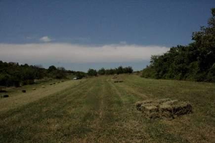
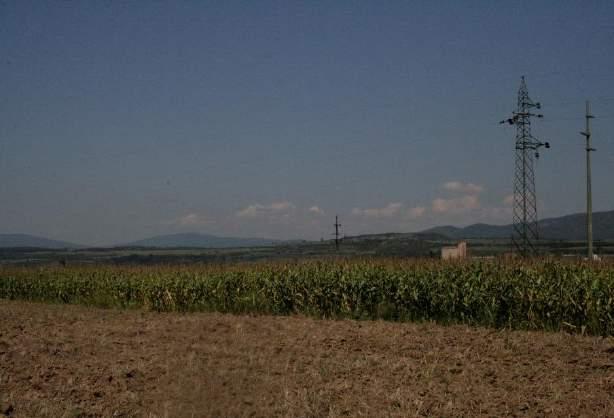
2 The statistic data General data in 2012 Municipality Aleksinac Number of holdings Utilized agricultural area (ha) Average UAA per holding (ha) 3,35 Utilized agricultural area by categories (%) in ,09% 0,97% 3,25% 10,84% 83,85% Arable land Fruit plantations Other Meadows and pastures Vineyards 1st Interim Meeting of the REAWG on ANC, Andrevlje

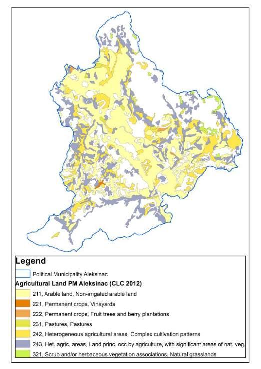
3 CORINE Land Cover 2012 Corine Land Cover Non-irrigated arable land 221 Vineyards 222 Fruit trees and berry plantations 231 Pastures 242 Complex cultivation patterns 243 Land principally occupied by agriculture with significant areas of natural vegetation 321 Natural grasslands Categories/CLC classes 2012 ha AGRICULTURAL AREAS 211 Non-irrigated arable land 20, Vineyards Fruit trees and berry plantations Pastures Complex cultivation patterns 6, Land principally occupied by agriculture with significant areas of natural vegetation 10,096.6 Sub-total 37,977.9 FORESTS AND SEMINATURAL AREAS 321 Natural grasslands Grand Total 38, st Interim Meeting of the REAWG on ANC, Andrevlje

4 Selecting the Layer of Territorial and Admistrative Division of Serbia
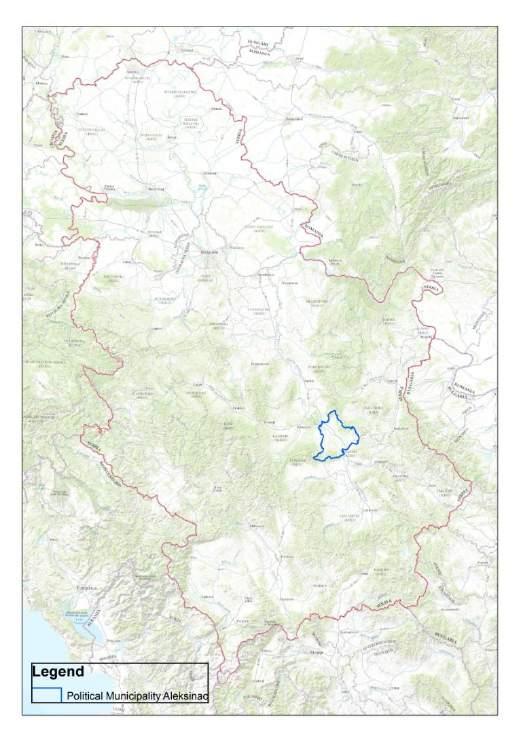
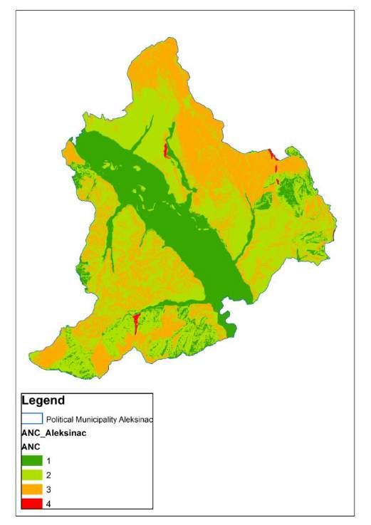
5 Political Municipality of Aleksinac

6 Climate Data Meteorogical Stations
7 Climate Data Selected SWAT Grid

8 Climate Data Database

9 Calculation of PET Eto Calculator

10 Climate Data Database With Calculated PET
11 Dryness Ratio of the Annual Precipitation (P) to the Annual Potentil Evapotranspiration (PET) P/PET <= 0.5
 per Year (1981")
12 Dryness - Calculated Sum of P and Sum of PET per Station (Grid Point) per Year ( )

13 Dryness Selected SWAT Grid Layer Joined With Database Tables
")
14 Dryness Ordinary Kriging for Sum of P (Year 2003)


15 Dryness Ordinary Kriging for Sum of PET (Year 2003)

16 Dryness Division of Rasters P/PET and Reclassified Raster (Year 2003)
17 Dryness Reclassified Raster Year 1981
18 Dryness Reclassified Raster Year 1982
19 Dryness Reclassified Raster Year 1983
20 Dryness Reclassified Raster Year 1984
21 Dryness Reclassified Raster Year 1985
22 Dryness Reclassified Raster Year 1986
23 Dryness Reclassified Raster Year 1987
24 Dryness Reclassified Raster Year 1988
25 Dryness Reclassified Raster Year 1989
26 Dryness Reclassified Raster Year 1990
27 Dryness Reclassified Raster Year 1991
28 Dryness Reclassified Raster Year 1992

29 Dryness Reclassified Raster Year 1993
30 Dryness Reclassified Raster Year 1994
31 Dryness Reclassified Raster Year 1995
32 Dryness Reclassified Raster Year 1996
33 Dryness Reclassified Raster Year 1997
34 Dryness Reclassified Raster Year 1998
35 Dryness Reclassified Raster Year 1999
36 Dryness Reclassified Raster Year 2000
37 Dryness Reclassified Raster Year 2001
38 Dryness Reclassified Raster Year 2002
39 Dryness Reclassified Raster Year 2003
40 Dryness Reclassified Raster Year 2004
41 Dryness Reclassified Raster Year 2005
42 Dryness Reclassified Raster Year 2006
43 Dryness Reclassified Raster Year 2007
44 Dryness Reclassified Raster Year 2008
45 Dryness Reclassified Raster Year 2009
46 Dryness Reclassified Raster Year 2010
47 Dryness Resulting Raster
48 Low Temperature Lenght of growing period (number of days) <= 180 days Defined by number of days with daily average temperature > 5 o C

49 Low Temperature Export of 365 Shape Files per Year (FC_y_xxxx_m_xx_d_xx)

50 Low Temperature Impotred Feature Classes (year GDB_1992_LowTemperature.mdb )
51 Low Temperature Form that Creates the Tables With Average Daily Temps as a Result of a Query

52 Low Temperature Tables With Average Daily Temps as a Result of a Query

53 Low Temperature Update of FC Tables of Attributes

54 Low Temperature Kriging Programmatically

55 Low Temperature Raster Layers of Ordinary Kriging
56 Low Temperature Reclassification

57 Low Temperature String for Raster Calculator

58 Low Temperature Results (1)

59 Low Temperature Results (2)
60 Steep Slope Change of elvation with respect to planimetric distance (%) Slope >= 15%

61 DEM(s) 1 Arc SECOND 1st Interim Meeting of the REAWG on ANC, Andrevlje

62 Steep Slope
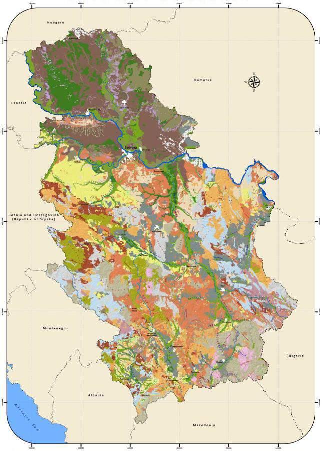
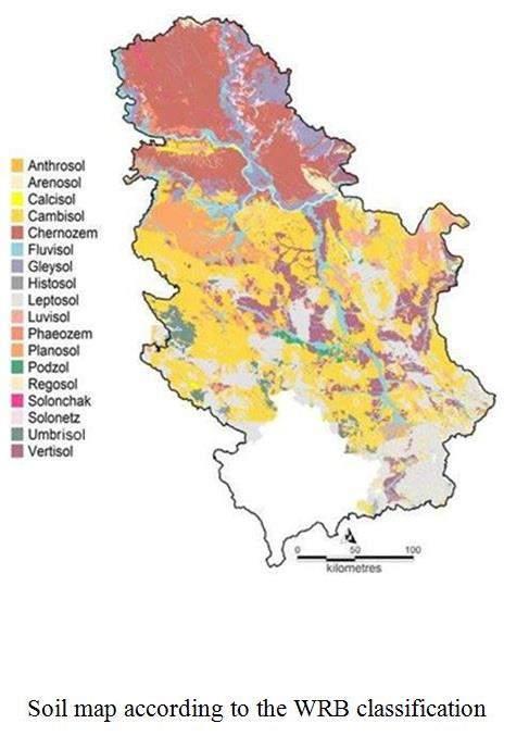
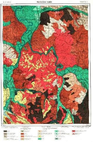
63 Soil

64 .


65 Soil Soil Map of Serbia part municipality of Aleksinac
66 Soil 926 cartographic units in Soil Map of Serbia 64 cartographic units in Soil Map of Serbia part municipality of Aleksinac
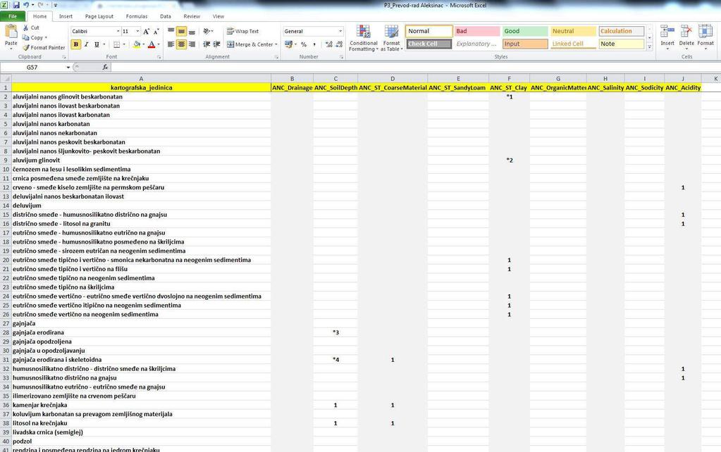
67 Soil
68 Cartographic units - for example: - all smeđa kisela zemljišta (brown acid soils) Soil - Acidity
69 Cartographic units - for example: - Bare i močvare - Jezera i bare - Mineralno barsko zemljište - Mineralno močvarno glinovito glejno zem. - Mineralno močvarno ilovasto glejno zemljište - Močvarno glejno zaslanjeno zemljište - Močvarno glejno zemljište - Organogeno mineralno-barsko zemljište - Pseudoglej obronačni - Aluvijalno zabareno zemljište - Aluvijalno-deluv. zem. Zabareno - Aluvijum zabareni... Soil - Drainage
70 Cartographic units - for example: - treset (peat) Soil Organic Matter
71 Cartographic units - for example: - solonchak - c.u. with words solončakast (solonchaklike) or zaslanjen (saline) Soil - Salinity
72 Cartographic units - for example: - solonetz - c.u. with words alkalizovan (alkaline) Soil - Sodicity
73 Cartographic units - for example: - lithosol - c.u. with words plitko (shallow) Soil Soil Depth
74 Soil ST Clay In JRC TECHNICAL REPORTS Updated Guidelines for Applying Common Criteria to Identify Agricultural Areas with Natural Constraints (2016) Threshold - the topsoil texture class is heavy clay ( 60% clay); or - the topsoil contains 30% or more clay and there is a soil layer with vertic properties within 100 cm of the soil surface. In Classification of Yugoslav soils vertic properties are diagnostic criteria for smonitza soil type (vertisol).

75 Soil ST Clay
76 Soil ST Coarse Material
77 Cartographic units - for example: - arenosol - c.u. with words peskovito (sandy) Soil ST Sandy Loam

78 Soil - All
79 Additional Field Investigation August 2016.
80 35.20%(clay); 23.68% (clay); 24.56% (clay); 34.36% (clay); 20.12% (clay); 33.56% clay Noncalcareous clayey alluvial deposit 27.24% clay Noncalcareous and clayey marsh black soil 47% (clay); 37.36% (clay);.
;.")
81 43.72% (clay);.
82 Soil Acidity: ph 5 (in water) Data of fertility control samples ( ) 0,37 % samples has a ph 5 (in water)..
83 .
84 ANC - Intersection
85 Thank you!
Status of soil, climate and digital mapping information in Serbia
 Status of soil, climate and digital mapping information in Serbia Dragana Vidojević of the Republic of Serbia Environmental Protection Agency, Ruže Jovanovića St. 27a, 11160 Belgrade, dragana.vidojevic@sepa.gov.rs;
ADELA PAȘCA, TEODOR RUSU. Bucharest, June 2018
 GIS INTEGRATION OF CLIMATE CHANGE THROUGH FAST CALCULATION OF TEMPERATURE AND PRECIPITATION MAPS FOR USE IN AGRICULTURAL LAND QUALITATIVE ASSESSMENT. CASE STUDY: ICLOD COMMUNE, CLUJ COUNTY, ROMANIA ADELA
Italian experience with the interpretation of FOCUS surface water scenarios from a regulatory point of view
 Italian experience with the interpretation of FOCUS surface water scenarios from a regulatory point of view G. Azimonti, G. Triacchini, D. Auteri, E. Redolfi, International Centre for Pesticides and Health
GeoPEARL_DE a Tool for Spatial Modelling of Pesticide Leaching Behaviour in Germany. Jörg Bangert
 GeoPEARL_DE a Tool for Spatial Modelling of Pesticide Leaching Behaviour in Germany Jörg Bangert Agenda Development of GeoPEARL_DE o Data sources o Spatial schematisation o Parameterisation Evaluation
Spatial Disaggregation of Land Cover and Cropping Information: Current Results and Further steps
 CAPRI CAPRI Spatial Disaggregation of Land Cover and Cropping Information: Current Results and Further steps Renate Koeble, Adrian Leip (Joint Research Centre) Markus Kempen (Universitaet Bonn) JRC-AL
The HSMU approach in CAPRI-DYNASPAT (Homogeneous Spatial Mapping Units)
") CAP Regional Impact Assessment - DYNAmic and SPATial dimension The HSMU approach in CAPRI-DYNASPAT (Homogeneous Spatial Mapping Units) Adrian Leip, Giulio Marchi Climate Change Unit / Joint Research Centre
CAP Regional Impact Assessment - DYNAmic and SPATial dimension The HSMU approach in CAPRI-DYNASPAT (Homogeneous Spatial Mapping Units) Adrian Leip, Giulio Marchi Climate Change Unit / Joint Research Centre
VENETO REGION PILOT AREA
 VENETO REGION PILOT AREA The pilot area is located in the north-east of Veneto region, located itself in the north-east of Italy. The area borders with Austria are in the northern part and run along high
Raster Analysis: An Example
 Raster Analysis: An Example Fires (1 or 4) Slope (1-4) + Geology (1-4) Erosion Ranking (3-12) 1 Typical Raster Model Types: Suitability Modeling: Where is optimum location? Distance Modeling: What is the
INTRODUCTION TO ARCGIS 10
 Department of Irrigation, Drainage and Landscape Engineering, Faculty of Civil Engineering, CTU Prague Institute of Hydraulics and Rural Water Management BOKU Vienna INTRODUCTION TO ARCGIS 10 MAIN WINDOW
Land accounting perspective on water resources management
 European Water 60: 161-166, 2017. 2017 E.W. Publications Land accounting perspective on water resources management G.T. Paschos, G.E. Bariamis * and E.A. Baltas Department of Water Resources and Environmental
Raster Analysis: An Example
 Raster Analysis: An Example Fires (1 or 4) Slope (1-4) + Geology (1-4) Erosion Ranking (3-12) 11/8/2016 GEO327G/386G, UT Austin 1 Typical Raster Model Types: Suitability Modeling: Where is optimum location?
Geometric and Landcover Signatures of Local Authorities in Peloponnesus
 Geometric and Landcover Signatures of Local Authorities in Peloponnesus GEORGE CH. MILIARESIS Department of Geology University of Patras Geology Department, University of Patras, Rion 265-04 GREECE gmiliar@upatras.gr
CORINE LAND COVER CROATIA
 CORINE LAND COVER CROATIA INTRO Primary condition in making decisions directed to land cover and natural resources management is presence of knowledge and high quality information about biosphere and its
VILLAGE INFORMATION SYSTEM (V.I.S) FOR WATERSHED MANAGEMENT IN THE NORTH AHMADNAGAR DISTRICT, MAHARASHTRA
 FOR WATERSHED MANAGEMENT IN THE NORTH AHMADNAGAR DISTRICT, MAHARASHTRA") VILLAGE INFORMATION SYSTEM (V.I.S) FOR WATERSHED MANAGEMENT IN THE NORTH AHMADNAGAR DISTRICT, MAHARASHTRA Abstract: The drought prone zone in the Western Maharashtra is not in position to achieve the agricultural
VILLAGE INFORMATION SYSTEM (V.I.S) FOR WATERSHED MANAGEMENT IN THE NORTH AHMADNAGAR DISTRICT, MAHARASHTRA Abstract: The drought prone zone in the Western Maharashtra is not in position to achieve the agricultural
MAFF Ministry of IfiriLE Agriculture Fisheries and Food
 MAFF Ministry of IfiriLE Agriculture Fisheries and Food STATEMENT OF PHYSICAL CHARACTERISTICS AND AGRICULTURAL LAND CLASSIFICATION UPSLAND, KIRKLINGTON NORTH YORKSHIRE EXTRACTION OF SAND AND GRAVEL MARCH
The Soils and Land Capability for Agriculture. Land North of Aberdeen, Aberdeenshire
 The Soils and Land Capability for Agriculture Of Land North of Aberdeen, Aberdeenshire Report prepared for Peter Radmall Associates May 2012 Reading Agricultural Consultants Ltd Beechwood Court, Long Toll,
Geographical position
 Geographical position Albania is located in South-Western Europe, in the Western of the Balkan peninsula, between the geographical coordinates 39 o 16' N latitude and 42 o 39' E longitude. The Republic
Agrometeorological activities in RHMSS
 Republic of Serbia Republic Hydrometeorological Service of Serbia Agrometeorological activities in RHMSS Department for applied climatology and agrometeorology www.hidmet.gov.rs Meteorological Observing
ABSTRACT The first chapter Chapter two Chapter three Chapter four
 ABSTRACT The researches regarding this doctoral dissertation have been focused on the use of modern techniques and technologies of topography for the inventory and record keeping of land reclamation. The
Supplementary material: Methodological annex
 1 Supplementary material: Methodological annex Correcting the spatial representation bias: the grid sample approach Our land-use time series used non-ideal data sources, which differed in spatial and thematic
Assessment of solid load and siltation potential of dams reservoirs in the High Atlas of Marrakech (Moorcco) using SWAT Model
 using SWAT Model") Assessment of solid load and siltation potential of dams reservoirs in the High Atlas of Marrakech (Moorcco) using SWAT Model Amal Markhi: Phd Student Supervisor: Pr :N.Laftrouhi Contextualization Facing
Assessment of solid load and siltation potential of dams reservoirs in the High Atlas of Marrakech (Moorcco) using SWAT Model Amal Markhi: Phd Student Supervisor: Pr :N.Laftrouhi Contextualization Facing
STANDARDIZED DATABASE OF LAND EVALUATION FOR AGRICULTURAL PRODUCTION
 STANDARDIZED DATABASE OF LAND EVALUATION FOR AGRICULTURAL PRODUCTION Nguyen Xuan Hai, Pham Thi Ha Nhung, Nguyen Quoc Viet VNU University of Sciences, Nguyen Trai, Hanoi, Vietnam E-Mail: nguyenxuanhai@hus.edu.vn
HNV Farming in Italy Context indicator CI37 Land cover approach
 Good Practice Workshop, Bonn 7-8 June 2016 Preparing the assessment of High Nature Value Farming in Rural Development Programmes 2014-2020 HNV Farming in Italy Context indicator CI37 Land cover approach
Serbia. Serbian Environmental Protection Agency. Dragana Vidojevic. Danube Basin esoter soil database meeting, Ispra, 5/2/2015-6/2/2015
 Serbian Environmental Protection Agency Serbia Danube Basin esoter soil database meeting, Ispra, 5/2/2015-6/2/2015 Dragana Vidojevic Head of department for indicators and reporting air SEPA what we do...
2.1.2 Land cover data
 2.1.2 Land cover data Land cover data was used as an approximate measure of the different habitat groupings throughout Britain. Land cover data was obtained from three sources The European Environment
Monitoring daily evapotranspiration in the Alps exploiting Sentinel-2 and meteorological data
 Monitoring daily evapotranspiration in the Alps exploiting Sentinel-2 and meteorological data M. Castelli, S. Asam, A. Jacob, M. Zebisch, and C. Notarnicola Institute for Earth Observation, Eurac Research,
W I N D R E S O U R C E A S S E S S M E N T
 W I N D R E S O U R C E A S S E S S M E N T Annual Energy Production Project: Hundhammer_WS_Express Layout: Layout1 Customer: WindSim 2014-01-29 WindSim AS Fjordgaten 15, N- 3125 Tønsberg, Norway phone.:
Raster Analysis; A Yellowstone Example 3/29/2018
 Fires (1 or 4) Typical Raster Model Types: Raster Analysis: An Example Suitability Modeling: Where is optimum location? Distance Modeling: What is the most efficient path from A to B? + Slope (1-4) Geology
Standardization of the land cover classes using FAO Land Cover Classification System (LCCS)
") Sofia, 17-18 September 2008, LPIS Workshop LPIS applications and quality 1 Standardization of the land cover classes using FAO Land Cover Classification System (LCCS) Pavel MILENOV Agriculture Unit, JRC
Sofia, 17-18 September 2008, LPIS Workshop LPIS applications and quality 1 Standardization of the land cover classes using FAO Land Cover Classification System (LCCS) Pavel MILENOV Agriculture Unit, JRC
SPATIAL AND TEMPORAL ANALYSIS OF THE DEGRADATION OF NATURAL RESOURCES IN RIVER LIKODRA WATERSHED
 Soil Erosion Modelling JRC Ispra 20-21-22 March 2017 University of Belgrade, Faculty of Forestry Department for Ecological Engineering in Protection of Soil and Water Resources SPATIAL AND TEMPORAL ANALYSIS
Raster Analysis; A Yellowstone Example 10/24/2013. M. Helper GEO327G/386G, UT Austin 2. M. Helper GEO327G/386G, UT Austin 4
 + Fires (1 or 4) Slope (1-4) Geology (1-4) Erosion Ranking (3-12) Raster Analysis: An Example Typical Raster Model Types: Suitability Modeling: Where is optimum location? Distance Modeling: What is the
Yaneev Golombek, GISP. Merrick/McLaughlin. ESRI International User. July 9, Engineering Architecture Design-Build Surveying GeoSpatial Solutions
 Yaneev Golombek, GISP GIS July Presentation 9, 2013 for Merrick/McLaughlin Conference Water ESRI International User July 9, 2013 Engineering Architecture Design-Build Surveying GeoSpatial Solutions Purpose
DESCRIPTION OF A HYDROLOGIC DATASET. Department of Environmental Sciences, Wageningen University and. Research Center. Wageningen, The Netherlands
 DESCRIPTION OF A HYDROLOGIC DATASET FOR THE BRISY SUBCATCHMENT R. T. Oosterho? and C. Paniconi y? Department of Environmental Sciences, Wageningen University and Research Center Wageningen, The Netherlands
Existing NWS Flash Flood Guidance
 Introduction The Flash Flood Potential Index (FFPI) incorporates physiographic characteristics of an individual drainage basin to determine its hydrologic response. In flash flood situations, the hydrologic
Dynamic Land Cover Dataset Product Description
 Dynamic Land Cover Dataset Product Description V1.0 27 May 2014 D2014-40362 Unclassified Table of Contents Document History... 3 A Summary Description... 4 Sheet A.1 Definition and Usage... 4 Sheet A.2
O\.OLSSON \ ASSOC I ATES
 O\.OLSSON \ ASSOC I ATES NRCS Soils Report Larry D. Knox Juniper Hills Private Landing Strip ) OAProject No. 012-1776 760 Horizon Drive, Suite 1021 Grand Junction, CO 815061 TEL 970.263.7800 I FAX 970.263.7456
STATEMENT OF PHYSICAL CHARACTERISTICS REPORT FOR WELLINGTON, HEREFORD AND WORCESTER MINERALS LOCAL PLAN
 STATEMENT OF PHYSICAL CHARACTERISTICS REPORT FOR WELLINGTON, HEREFORD AND WORCESTER MINERALS LOCAL PLAN M J Wood ADAS Ref: 25/RPT/0039 Resource Planning Team Job No: 164/94 ADAS Statutory Group MAFF Ref:
Using object oriented technique to extract jujube based on landsat8 OLI image in Jialuhe Basin
 Journal of Image Processing Theory and Applications (2016) 1: 16-20 Clausius Scientific Press, Canada Using object oriented technique to extract jujube based on landsat8 OLI image in Jialuhe Basin Guotao
Evaluation of gvsig and SEXTANTE Tools for Hydrological Analysis
 Evaluation of gvsig and SEXTANTE Tools for Hydrological Analysis 6th gvsig Conference, Valencia, SPAIN Prof. Dr-Ing Dietrich Schrödera Mudogah Hildahb and Franz Davidb Stuttgart University of Applied Sciences
Spectroscopy Applications
 Spectroscopy Applications Soil spectroscopy as a tool for the spatial assessment of soil erosion states in agricultural semi-arid Spain Sabine Chabrillat 1, Thomas Schmid 2, Robert Milewski 1, Manuel Rodriguez
PRINCIPLES OF PHOTO INTERPRETATION
 PRINCIPLES OF PHOTO INTERPRETATION Photo Interpretation the act of examining photographic images for the purpose of identifying objects and judging their significance an art more than a science Recognition
FOREST FIRE HAZARD MODEL DEFINITION FOR LOCAL LAND USE (TUSCANY REGION)
") FOREST FIRE HAZARD MODEL DEFINITION FOR LOCAL LAND USE (TUSCANY REGION) C. Conese 3, L. Bonora 1, M. Romani 1, E. Checcacci 1 and E. Tesi 2 1 National Research Council - Institute of Biometeorology (CNR-
FOREST FIRE HAZARD MODEL DEFINITION FOR LOCAL LAND USE (TUSCANY REGION) C. Conese 3, L. Bonora 1, M. Romani 1, E. Checcacci 1 and E. Tesi 2 1 National Research Council - Institute of Biometeorology (CNR-
A Help Guide for Using gssurgo to Find Potential Wetland Soil Landscapes
 A Help Guide for Using gssurgo to Find Potential Wetland Soil Landscapes Wetland Mapping Consortium Webinar September 17, 2014 Dr. John M. Galbraith Crop & Soil Environmental Sciences Virginia Tech Wetland
New Results of Critical Load Calculation including Biodiversity
 33 rd ICP M & M Task Force Meeting New Results of Critical Load Calculation including Biodiversity Hans-Dieter Nagel, Angela Schlutow & Yolandi Bouwer (OEKO-DATA) Markus Geupel & Thomas Scheuschner (UBA)
Alaska, USA. Sam Robbins
 Using ArcGIS to determine erosion susceptibility within Denali National Park, Alaska, USA Sam Robbins Introduction Denali National Park is six million acres of wild land with only one road and one road
Custom Soil Resource Report for Multnomah County Area, Oregon
 United States Department of Agriculture Natural Resources Conservation Service A product of the National Cooperative Soil Survey, a joint effort of the United States Department of Agriculture and other
Application of SWAT Model to Estimate the Runoff and Sediment Load from the Right Bank Valleys of Mosul Dam Reservoir
 Application of SWAT Model to Estimate the Runoff and Sediment Load from the Right Bank Valleys of Mosul Dam Reservoir Dr Mohammad Ezeel Deen Prof. Nadhir Al-Ansari Prof Sven Knutsson Figure 1.Map of Iraq
Global Land Cover Mapping
 Global Land Cover Mapping and its application in SDGs Prof. Chen Jun 1, Dr. He Chaoying 2 1 National Geomatics Center of China (NGCC) 2 Ministry of Natural Resources, P.R.China May 30, 2018, Copenhagen
INTERNATIONAL JOURNAL OF PURE AND APPLIED RESEARCH IN ENGINEERING AND TECHNOLOGY
 INTERNATIONAL JOURNAL OF PURE AND APPLIED RESEARCH IN ENGINEERING AND TECHNOLOGY A PATH FOR HORIZING YOUR INNOVATIVE WORK SPECIAL ISSUE FOR NATIONAL LEVEL CONFERENCE "SUSTAINABLE TECHNOLOGIES IN CIVIL
Predicting ectotherm disease vector spread. - Benefits from multi-disciplinary approaches and directions forward
 Predicting ectotherm disease vector spread - Benefits from multi-disciplinary approaches and directions forward Naturwissenschaften Stephanie Margarete THOMAS, Carl BEIERKUHNLEIN, Department of Biogeography,
A framework for the 1:1,000,000 soil database of China
 Symposium no. 62 Paper no. 1757 Presentation: poster A framework for the 1:1,000,000 soil database of China SHI X.Z. (1), YU D.S. (1), PAN X.Z. (1), SUN W.X. (1), GONG Z.G. (1), Warner E.D. (2) and Petersen
Raster Spatial Analysis Specific Theory
 RSATheory.doc 1 Raster Spatial Analysis Specific Theory... 1 Spatial resampling... 1 Mosaic... 3 Reclassification... 4 Slicing... 4 Zonal Operations... 5 References... 5 Raster Spatial Analysis Specific
The Study of Soil Fertility Spatial Variation Feature Based on GIS and Data Mining *
 The Study of Soil Fertility Spatial Variation Feature Based on GIS and Data Mining * Chunan Li, Guifen Chen **, Guangwei Zeng, and Jiao Ye College of Information and Technology, Jilin Agricultural University,
Custom Soil Resource Report for Forrest County, Mississippi
 United States Department of Agriculture Natural Resources Conservation Service A product of the National Cooperative Soil Survey, a joint effort of the United States Department of Agriculture and other
SOIL INFORMATION FOR PUMPED WATER STORAGE SCHEME, STEELPOORT VALLEY
 REPORT On contract research for Bohlweki Environmental SOIL INFORMATION FOR PUMPED WATER STORAGE SCHEME, STEELPOORT VALLEY February 2007 By D.G. Paterson ARC-Institute for Soil, Climate and Water, Private
LUCAS: current product and its evolutions
 LUCAS: current product and its evolutions Workshop Land Use and Land Cover products: challenges and opportunities Brussels 15 Nov 2017 Eurostat E4: estat-dl-lucas@ec.europa.eu Contents 1) The context 2)
PMlab Action 4. Interpolation Tool for Daily PM10 Concentrations in the Euregio Maas-Rhine
 PMlab Action 4 Interpolation Tool for Daily PM10 Concentrations in the Euregio Maas-Rhine Starting Point in the EMR No border crossing information platform for public and local actors on air quality outside
Evaluation of the SWAT Model Setup Process Through A Case Study in Roxo Catchment, Portugal
 Evaluation of the SWAT Model Setup Process Through A Case Study in Roxo Catchment, Portugal Mustafa Gökmen Master Degree in on Geo-information and Earth Observation for Integrated Catchment and Water Resources
Custom Soil Resource Report for Clackamas County Area, Oregon
 United States Department of Agriculture Natural Resources Conservation Service A product of the National Cooperative Soil Survey, a joint effort of the United States Department of Agriculture and other
GIS model & modeling
 GIS model & modeling Model : a simplified representation of a phenomenon or a system. GIS modeling : the use of GIS in the process of building models with spatial data. Basic requirement in modeling :
Relationship of the Brimstone field trial site to the D2 FOCUS Surface Water Scenario
 Relationship of the Brimstone field trial site to the D2 FOCUS Surface Water Scenario Dr Paul Sweeney Syngenta ECPA project contracted to NRSI, Silsoe Background The FOCUS sw D2 scenario represents an
Spanish national plan for land observation: new collaborative production system in Europe
 ADVANCE UNEDITED VERSION UNITED NATIONS E/CONF.103/5/Add.1 Economic and Social Affairs 9 July 2013 Tenth United Nations Regional Cartographic Conference for the Americas New York, 19-23, August 2013 Item
CHAPTER VII FULLY DISTRIBUTED RAINFALL-RUNOFF MODEL USING GIS
 80 CHAPTER VII FULLY DISTRIBUTED RAINFALL-RUNOFF MODEL USING GIS 7.1GENERAL This chapter is discussed in six parts. Introduction to Runoff estimation using fully Distributed model is discussed in first
Weathering is the process that breaks down rock and other substances at Earth s surface
 Chapter 8 Notes Weathering is the process that breaks down rock and other substances at Earth s surface Factors that contribute to weathering Heat Cold Water Ice O 2 & CO 2 in the atmosphere Examples of
Applying Hazard Maps to Urban Planning
 Applying Hazard Maps to Urban Planning September 10th, 2014 SAKAI Yuko Disaster Management Expert JICA Study Team for the Metro Cebu Roadmap Study on the Sustainable Urban Development 1 Contents 1. Outline
Introduction to Soil Science and Wetlands Kids at Wilderness Camp
 Introduction to Soil Science and Wetlands Kids at Wilderness Camp Presented by: Mr. Brian Oram, PG, PASEO B.F. Environmental Consultants http://www.bfenvironmental.com and Keystone Clean Water Team http://www.pacleanwater.org
Influence of Paleochannels on Seepage
 Study 4 Influence of Paleochannels on Seepage Public Draft 2014 Monitoring and Analysis Plan September 2013 August 2012 Influence of Paleochannels on Seepage 1. Statement of Need Historical maps, aerial
AGRICULTURAL LAND CLASSIFICATION ST HELENS UDP BIRCH TREE FARM (SITE 33)
") / ' '' / / AGRICULTURAL LAND CLASSIFICATION ST HELENS UDP BIRCH TREE FARM (SITE 33) R D Metcalfe Resource Planning Team ADAS Statutory Group WOLVERHAMPTON ADAS Ref: Job No: MAFFRef: 25/RPT/D689 135/95
/ ' '' / / AGRICULTURAL LAND CLASSIFICATION ST HELENS UDP BIRCH TREE FARM (SITE 33) R D Metcalfe Resource Planning Team ADAS Statutory Group WOLVERHAMPTON ADAS Ref: Job No: MAFFRef: 25/RPT/D689 135/95
Custom Soil Resource Report for Okeechobee County, Florida
 United States Department of Agriculture Natural Resources Conservation Service A product of the National Cooperative Soil Survey, a joint effort of the United States Department of Agriculture and other
Effect of land use/land cover changes on runoff in a river basin: a case study
 Water Resources Management VI 139 Effect of land use/land cover changes on runoff in a river basin: a case study J. Letha, B. Thulasidharan Nair & B. Amruth Chand College of Engineering, Trivandrum, Kerala,
High Speed / Commuter Rail Suitability Analysis For Central And Southern Arizona
 High Speed / Commuter Rail Suitability Analysis For Central And Southern Arizona Item Type Reports (Electronic) Authors Deveney, Matthew R. Publisher The University of Arizona. Rights Copyright is held
LEPTOSOLS (LP) Definition of Leptosols
 Definition of Leptosols") LEPTOSOLS (LP) The Reference Soil Group of the Leptosols accommodates very shallow soils over hard rock or highly calcareous material, but also deeper soils that are extremely gravelly and/or stony. Lithosols
LEPTOSOLS (LP) The Reference Soil Group of the Leptosols accommodates very shallow soils over hard rock or highly calcareous material, but also deeper soils that are extremely gravelly and/or stony. Lithosols
USING GIS TECHNOLOGY IN HYDROGEOLOGICAL ANALYSIS
 USING GIS TECHNOLOGY IN HYDROGEOLOGICAL ANALYSIS CAMELIA SLAVE 1, IOANA VIZIREANU 2 1. University of Agronomic Sciences and Veterinary Medicine, Mărăști no 59, Bucharest 011464, Romania 2. National Institute
Classification according to patent rock material/origin, soil distribution and orders
 Classification according to patent rock material/origin, soil distribution and orders Alluvial Soils Shales and Sandstone Soils Limestone Soils Chocolate Hills: Limestone formation Andesite and Basalt
The stability of ecological corridors as illustrated by examples from Poland
 Gerlée A., 11. The stability of ecological corridors as illustrated by examples from Poland. The Problems of Landscape Ecology. Vol. XXX. 371-376. The stability of ecological corridors as illustrated by
LAND SUITABILITY STUDY IN LAND DEGRADED AREA DUE TO MINING IN DHANBAD DISTRICT, JHARKHAND.
 LAND SUITABILITY STUDY IN LAND DEGRADED AREA DUE TO MINING IN DHANBAD DISTRICT, JHARKHAND. Saranathan, E a*, Loveson, V.J b. and Victor Rajamanickam, G c a School of Civil Engineering, SASTRA, Thanjavur
Remote sensing technique to monitoring the risk of soil degradation using NDVI
 Remote sensing technique to monitoring the risk of soil degradation using NDVI Ahmed Asaad Zaeen Remote sensing Unit, College of Science, University of Baghdad, Iraq ahmed_a_z@scbaghdad.com Abstract. In
MODELLING LAND USE CHANGE ON A REGIONAL SCALE
 MODELLING LAND USE CHANGE ON A REGIONAL SCALE W. Lahmer 1, A. Becker 1, B. Pfützner 2 1 Potsdam Institute for Climate Impact Research, Telegrafenberg, D-14412 Potsdam, Germany 2 Bureau for Applied Hydrology
Custom Soil Resource Report for Clark County, Washington
 United States Department of Agriculture Natural Resources Conservation Service A product of the National Cooperative Soil Survey, a joint effort of the United States Department of Agriculture and other
The Palfai Drought Index (PaDI) Expansion of applicability of Hungarian PAI for South East Europe (SEE) region Summary
 Expansion of applicability of Hungarian PAI for South East Europe (SEE) region Summary") The Palfai Drought Index () Expansion of applicability of Hungarian PAI for South East Europe (SEE) region Summary In Hungary the Palfai drought index (PAI) worked out for users in agriculture and in water
The Palfai Drought Index () Expansion of applicability of Hungarian PAI for South East Europe (SEE) region Summary In Hungary the Palfai drought index (PAI) worked out for users in agriculture and in water
Spatio-temporal models
 Spatio-temporal models Involve a least a three dimensional representation of one or more key attribute variation in planar (X-Y) space and through time. (a 4 th dimension could also be use, like Z for
Soil Types. Detailed
 Soil Science and Soil Physics Lecture 12 Soil Types Detailed Taxonomy according to FAO/UNESCO Basic soil horizons O A E B C R Plant litter at various levels of decomposition and humus - Organic matter)
 United States Department of Agriculture Natural Resources Conservation Service A product of the National Cooperative Soil Survey, a joint effort of the United States Department of Agriculture and other
Evaluation of gvsig and SEXTANTE Tools for Hydrological Analysis Schröder Dietrich a, Mudogah Hildah b and Franz David b
 Evaluation of gvsig and SEXTANTE Tools for Hydrological Analysis Schröder Dietrich a, Mudogah Hildah b and Franz David b ab Photogrammetry and Geo-informatics Masters Programme, Stuttgart University of
Supplementary Material: Crop & Pasture Science, 2013, 64(12),
,") 10.1071/CP13168_AC CSIRO 2013 Supplementary Material: Crop & Pasture Science, 2013, 64(12), 1182 1194. Hydrological and water-use efficiency implications of geomorphological stratification in palæochannels
10.1071/CP13168_AC CSIRO 2013 Supplementary Material: Crop & Pasture Science, 2013, 64(12), 1182 1194. Hydrological and water-use efficiency implications of geomorphological stratification in palæochannels
MODELING RUNOFF RESPONSE TO CHANGING LAND COVER IN PENGANGA SUBWATERSHED, MAHARASHTRA
 MODELING RUNOFF RESPONSE TO CHANGING LAND COVER IN PENGANGA SUBWATERSHED, MAHARASHTRA Abira Dutta Roy*, S.Sreekesh** *Research Scholar, **Associate Professor Centre for the Study of Regional Development,
WMS 9.0 Tutorial GSSHA Modeling Basics Infiltration Learn how to add infiltration to your GSSHA model
 v. 9.0 WMS 9.0 Tutorial GSSHA Modeling Basics Infiltration Learn how to add infiltration to your GSSHA model Objectives This workshop builds on the model developed in the previous workshop and shows you
GIS AND REMOTE SENSING FOR WATER RESOURCE MANAGEMENT
 GIS AND REMOTE SENSING FOR WATER RESOURCE MANAGEMENT G. GHIANNI, G. ADDEO, P. TANO CO.T.IR. Extension and experimental station for irrigation technique - Vasto (Ch) Italy. E-mail : ghianni@cotir.it, addeo@cotir.it,
The future of the Lowland Belizean Savannas?.
 The future of the Lowland Belizean Savannas?. Using cluster analysis to explore multivariate spatial patterns in savanna soils PETER FURLEY & SARAH BEADLE UK Belize association 15 th November 2014 Outline
Hydrologic Modelling of the Upper Malaprabha Catchment using ArcView SWAT
 Hydrologic Modelling of the Upper Malaprabha Catchment using ArcView SWAT Technical briefs are short summaries of the models used in the project aimed at nontechnical readers. The aim of the PES India
Fig. 1: Test area the Municipality of Mali Idjos, Cadastral Municipality Feketic
 Remote Sensing Application for Agricultural Land Value Classification Integrated in the Land Consolidation Survey Stojanka Brankovic, Ljiljana Parezanovic Republic Geodetic Authority, Belgrade, Serbia
Utility of National Spatial Data for Conservation Design Projects
 Utility of National Spatial Data for Conservation Design Projects Steve Williams Biodiversity and Spatial Information Center North Carolina State University PIF CDW St. Louis, MO April 11, 2006 Types of
Exercise 6: Using Burn Severity Data to Model Erosion Risk
 Exercise 6: Using Burn Severity Data to Model Erosion Risk Document Updated: November 2009 Software Versions: ERDAS Imagine 9.3 and ArcGIS 9.3, Microsoft Office 2007 Introduction A common use of burn severity
JRC TECHNICAL REPORT
 JRC TECHNICAL REPORT Report on the Activities realized in 2010 within the Service Level Agreement between JRC and EFSA, as a support of the FATE and ECOREGION Working Groups of EFSA PPR. (SLA/EFSA-JRC/2008/01)
Grant 0299-NEP: Water Resources Project Preparatory Facility
 Document Produced under Grant Project Number: 45206 May 2016 Grant 0299-NEP: Water Resources Project Preparatory Facility Final Report Volume 3 East Rapti (1 of 9) Prepared by Pvt. Ltd. For Ministry of
The TexasET Network and Website User s Manual
 The TexasET Network and Website http://texaset.tamu.edu User s Manual By Charles Swanson and Guy Fipps 1 September 2013 Texas AgriLIFE Extension Service Texas A&M System 1 Extension Program Specialist;
BASIC SPATIAL ANALYSIS TOOLS IN A GIS. data set queries basic statistics buffering overlay reclassification
 BASIC SPATIAL ANALYSIS TOOLS IN A GIS data set queries basic statistics buffering overlay reclassification GIS ANALYSIS TOOLS GIS ANALYSIS TOOLS Database tools: query and summarize (similar to spreadsheet
SIF_7.1_v2. Indicator. Measurement. What should the measurement tell us?
 Indicator 7 Area of natural and semi-natural habitat Measurement 7.1 Area of natural and semi-natural habitat What should the measurement tell us? Natural habitats are considered the land and water areas
Spatial Modeling of Agricultural Land-Use Change at Global Scale
 NCAR IAM Group Annual Meeting, 19 Aug 013 Spatial Modeling of Agricultural Land-Use Change at Global Scale Prasanth Meiyappan PhD Candidate University of Illinois at Urbana-Champaign With contributions
Custom Soil Resource Report for Clackamas County Area, Oregon
 United States Department of Agriculture Natural Resources Conservation Service A product of the National Cooperative Soil Survey, a joint effort of the United States Department of Agriculture and other