Spatial Modeling of Agricultural Land-Use Change at Global Scale
|
|
|
- Peregrine Simon
- 6 years ago
- Views:
Transcription
1 NCAR IAM Group Annual Meeting, 19 Aug 013 Spatial Modeling of Agricultural Land-Use Change at Global Scale Prasanth Meiyappan PhD Candidate University of Illinois at Urbana-Champaign With contributions from Michael Dalton (NOAA), Brian O Neill (NCAR) & Atul Jain (U of I) Acknowledgement: NASA LCLUC Program
2 Why model land use at global scale Two key motivations Several key drivers of land use and its impacts have no regional boundaries and substantial feedbacks exist between them. Regions across the world are interconnected through global markets and trade that can shift the land requirements between regions.
3 Structure of IAMs Demographic, Markets, And Development Behavior Coarse resolution: world split into 9-4 regions Land-Use/Land-Cover Spatial Allocation Downscaling Biophysical Process Models Requires land information on uniform geographic grids: typically: 0.5 x 0.5 lat/lon
4 Objectives Develop a new land-use downscaling technique, with the following attributes (version 1) Address the mismatch between the scales at which landuse decisions are made and the scale at which global scale models are applied Account for variability in nature of driving factor Suitable for long-term projections Validated Can handle land-use competition Land-use representation using continuous field approach Meiyappan et al. (in prep)

5 Land-Use Allocation Framework
6 Econometric Framework for Land-Use Allocation Underlying Economic Motivation: Profit maximization of individual landowners at each grid cell thereby reflecting small scale decisions at larger scales Mathematical Formulation Component 1: Static Profit Maximization Function Maximize Maximize ( t t ) t ( t ) P W Y R Y l= 1 ( ) ( ) t t R Y S l = 1 Equation 1 Equation 'l' 't' ' g' t ' Y ' ( P t W t ) Y t Notations land-use type (1=crop, =pasture, 3= unmanaged land) time (year) grid cell area of land use net profit t Y 0 l= 1 Y t A g Grid cell level constraints ' R ( Y ' S t t ) ' ' α ' P t non-linear cost term W t '
7 Econometric Framework for Land-Use Allocation (Cont.) Component : Dynamic Adjustment Cost Model Minimize l= 1 Q ( t t 1) Y Y Equation 3 Notations ' Q ' Constant (adjustment cost per unit area) Overall Objective Function: Component 1 + Component Minimize l = 1 R ( t t ) ( t t 1) Y S + Q Y Y 3 Constraints imposed t Y 0 N t Y g 1 = l= 1 Y t A = total area demand g grid cell level constraints for land type ' l' within the aggregate region 1 regional level constraint
8 Regression Technique for Land Suitability Fractional Multinomial Logistic Regression (FMNL) Allows fractional outcomes More than two dependent variables can be modeled simultaneously 0 F 1 F = 3 e k = 1 β e 0l β + X 0k 3 l= 1 T + X F = 1 β l T k g β k 'l' 't' ' X ' S t = Notations land-use type (1=crop, =pasture, 3= unmanaged land) time (notation suppressed) Vector of driving factors A g F t World split into 35 distinct geopolitical regions; separate equations are derived for each region. Multicollinearity dealt using elastic-net regularization Spatial Autocoorelation - Autocovariate terms FMNL and Elastic-net merged using coordinate descent aorithm ' g' ' t F ' ' Ag ' grid cell Fraction of grid cell area Area of grid cell
9 Determining Local Land Suitability Broad Category Explanatory Factor Unit Climate Climate Variability Soil Characteristics Terrain Characteristics Seasonally averaged temperature Seasonally averaged precipitation Seasonally averaged Potential Evapotranspiration (PET) K mm/day mm/day Squared seasonally averaged temperature K Squared seasonally averaged precipitation mm /day Squared seasonally averaged PET mm /day Seasonal Temperature Humidity Index (THI) C Seasonal Palmer Drought Severity Index (PDSI) [-] Heat wave duration index Simple daily precipitation intensity index Rooting Conditions and Nutrient Retention Capacity Nutrient Availability Oxygen Availability Chemical Composition (indicates toxicities, salinity and sodicity) Workability (indicates texture, clay mineralogy and soil bulk-density) Elevation, Altitude and Slope Combined No of days mm/day [-] Socio-economic Spatial Autocorrelation Built-up/urban land area Urban population density Rural population density Rate of change in rural population density Rate of change in urban population density Market Influence Index Cropland Autocovariate Pastureland Autocovariate Fraction of grid area [m /m ] Inhabitants/km Inhabitants/km /yr International dollars/person Fraction of grid area [m /m ]
10 Historical Data for Explanatory Factors: Category Climate Soil Constraints Terrain Constraints Data Variable Temperature (T a ) Daily Average Maximum Temperature (T max ) Description/ Units o C Spatial Characteris tics Period of Availability degrees (monthly) Potential Evapotranspiration Millimeters (lat/lon) Precipitation CRU TS # Wet Day Frequency Palmer Drought Severity Index (PDSI) Rooting Conditions and Nutrient Retention Capacity Nutrient Availability Oxygen Availability Chemical Composition (indicates toxicities, Salinity and Sodicity) Workability (indicates texture, clay mineralogy and soil bulk-density) Elevation, Slope and Inclination Combined Urban/built-up land Urban Population Rural Population days No units Categorical Data classified into 7 gradient classes of land suitability for agriculture Categorical Data classified into 9 gradient classes % of grid-cell area Inhabitants/k m.5 (lat/lon) 5 minutes^ (lat/lon) 5 minutes^ (lat/lon) (monthly) (monthly) Constant with time Source Climatic Research Unit (CRU) TS 3.1 (updated estimates based on Mitchell and Jones, 005) CRU TS 3.0 & Dai et al. (011a,b) FAO/IIASA, 010. Global Agro-ecological Zones (GAEZ v3.0). FAO, Rome, Italy and IIASA, Laxenburg, Austria. 10,000 BC 005 AD (decadal) % Goldewijk et al. (010) Socio- Economic Factors Gross Domestic Product (GDP) per capita Constant 1990 international (Geary- Khamis) dollars/perso n National level 1 AD-010 (annually between ) $ Bolt and Van Zanden (013) (The Maddison Project - n-project/home.htm) Market Accessibility No units 1 km^ (lat/lon) ~005 Verburg et al. (011)
11 Historical Land-Use Data: Existing data sets are based on data-model fusion Klein Goldewijk et al. (011) HYDE reconstruction Ramankutty and Foley (1999) years of cropland data set Ramankutty et al., (008) - crop and pasture, circa 000 Ramankutty (01) updated data set version II
12 Regression Technique for Land Suitability Fractional Multinomial Logistic Regression (FMNL) Allows fractional outcomes More than two dependent variables can be modeled simultaneously 0 F 1 F = 3 e k = 1 β e 0l β + X 0k 3 l= 1 T + X F = 1 β l T k g β k 'l' 't' S t = Notations land-use type (1=crop, =pasture, 3= unmanaged land) A time (notation suppressed) g F t ' g' ' t F ' Ag ' ' grid cell Fraction of grid cell area Area of grid cell World split into 35 distinct geopolitical regions; separate equations are derived for each region. Multicollinearity dealt using elastic-net regularization Spatial Autocoorelation - Autocovariate terms FMNL and Elastic-net merged using coordinate descent aorithm Regression coefficients were standardized for comparison data used for fitting the FMNL regression
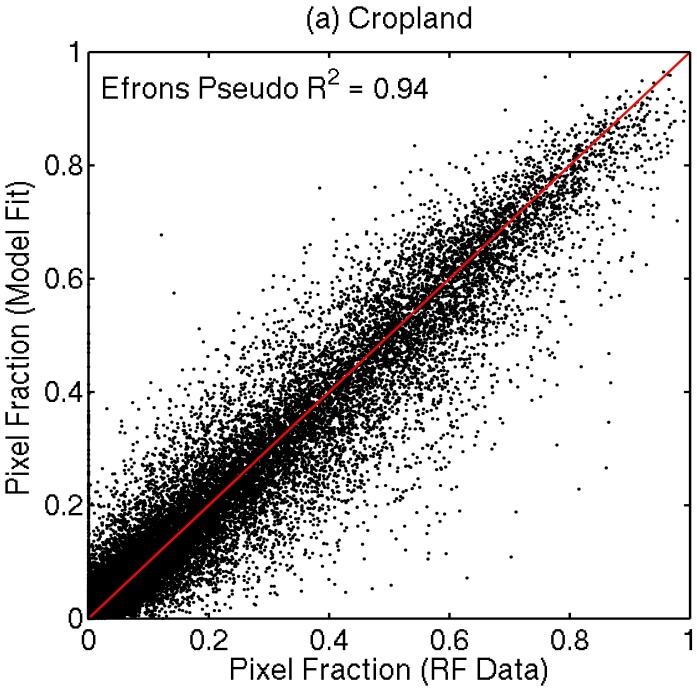

13 Results: Performance of Regression Technique
14 Results: Performance of Regression Technique Units: % of grid cell area
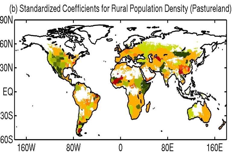

15 Spatial Characteristics of Explanatory Variables
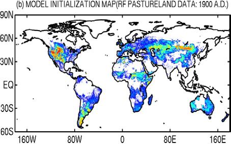
16 Setup for Model Validation

17 Historical Land-Use Data Aggregation Nine regions based on PET model


18 Results from Model Validation Units: % of grid cell area
19 Model Estimated Net transitions: Units: km /yr
20 Determining Land-Use Transitions Meiyappan and Jain (01)


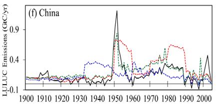


21 Carbon Emissions from ISAM Initial testing LEGENDS: DOWNSCALED HYDE RF HOUGHTON
22 How does a proportional downscaling method perform historically Minimize l = 1 R ( t t ) ( t t 1) Y S + Q Y Y Eliminate R ( t t ) Y S Minimize l= 1 Q ( t t 1) Y Y
23 How does a proportional downscaling method perform historically


24 How does a proportional downscaling method perform historically Net transitions: Units: % of grid cell area


25 Applications from our Validation Experiment Spatial determinants of existing land-use patterns
26 Applications from our Validation Experiment How different driving factors change with the scale of analysis?

27 Applications from our Validation Experiment How different driving factors contributed to the 0 th century landuse patterns? Units: % of grid cell area

28 Explaining the causes of historical land-use change patterns (cont.) Units: % of grid cell area
29 Discussion Methodological Advantages Suited for long-term projections Continuous field approach State of the art elastic-net for multicollinearity Handles land-use competition consistently
30 Discussion Known Issues/Limitations Irrigation not included due to data limitations Crude method to calibrate the relative weighing between static profit maximization function and the dynamic cost adjustment term Further room available for methodological improvements Land-Use Intensification

31 The Big Picture: Coupled Modeling Framework

32
33 Downscaling in Current Approaches IMAGE, MagPie, MIT-EPPA follows the approach of traditional geographic models; empirical rules based on current land use are assumed to hold true for the future (up to 100) GLOBIO3, iesm-glm land use demands allocated as close as possible to existing land-use patterns In common The downscaling aorithms have not been validated in the time scales at which they are applied for [van Asselen & Verburg, 013] Land-use competition handled implicitly or not at all considered [Heistermann et al., 006]

34 Land cover/use representation in IAMs Typically 0.5 or coarser IMAGE MagPie GLOBIOM Nexus land-use model IMAGE LandSHIFT - 5 min IMAGE - 5 min van Asselen & Verburg (013); Verburg et al. (01)
Constructing Global-Scale Spatial Population Scenarios. Bryan Jones, CGD-IAM, NCAR Boulder, CO August 19, 2013
 Constructing Global-Scale Spatial Population Scenarios Bryan Jones, CGD-IAM, NCAR Boulder, CO August 19, 2013 NCAR Community Demographic Model (CDM) Urbanization Projection (National) Household Projection
Séminaire de l'umr Economie Publique. Spatial Disaggregation of Agricultural. Raja Chakir. February 21th Spatial Disaggregation.
 Séminaire de l'umr Economie Publique : An : An February 21th 2006 Outline : An 1 2 3 4 : An The latest reform the Common Policy (CAP) aims to encourage environmentally friendly farming practices in order
Migration Modelling using Global Population Projections
 Migration Modelling using Global Population Projections Bryan Jones CUNY Institute for Demographic Research Workshop on Data and Methods for Modelling Migration Associated with Climate Change 5 December
Supplementary Information For: Future fire emissions associated with projected land use change in Sumatra
 Supplementary Information For: Future fire emissions associated with projected land use change in Sumatra Marlier, M., DeFries, R., Pennington, D., Nelson, E., Ordway, E.M., Lewis, J., Koplitz, S.N., &
Predicting ectotherm disease vector spread. - Benefits from multi-disciplinary approaches and directions forward
 Predicting ectotherm disease vector spread - Benefits from multi-disciplinary approaches and directions forward Naturwissenschaften Stephanie Margarete THOMAS, Carl BEIERKUHNLEIN, Department of Biogeography,
Modelling changes in the runoff regime in Slovakia using high resolution climate scenarios
 Modelling changes in the runoff regime in Slovakia using high resolution climate scenarios K. HLAVČOVÁ, R. VÝLETA, J. SZOLGAY, S. KOHNOVÁ, Z. MACUROVÁ & P. ŠÚREK Department of Land and Water Resources
CLIMATE MODEL DOWNSCALING: HOW DOES IT WORK AND WHAT DOES IT TELL YOU?
 rhgfdjhngngfmhgmghmghjmghfmf CLIMATE MODEL DOWNSCALING: HOW DOES IT WORK AND WHAT DOES IT TELL YOU? YAN FENG, PH.D. Atmospheric and Climate Scientist Environmental Sciences Division Argonne National Laboratory
Drought Monitoring with Hydrological Modelling
 st Joint EARS/JRC International Drought Workshop, Ljubljana,.-5. September 009 Drought Monitoring with Hydrological Modelling Stefan Niemeyer IES - Institute for Environment and Sustainability Ispra -
Spatial Disaggregation of Land Cover and Cropping Information: Current Results and Further steps
 CAPRI CAPRI Spatial Disaggregation of Land Cover and Cropping Information: Current Results and Further steps Renate Koeble, Adrian Leip (Joint Research Centre) Markus Kempen (Universitaet Bonn) JRC-AL
Land accounting perspective on water resources management
 European Water 60: 161-166, 2017. 2017 E.W. Publications Land accounting perspective on water resources management G.T. Paschos, G.E. Bariamis * and E.A. Baltas Department of Water Resources and Environmental
Analysis of real-time prairie drought monitoring and forecasting system. Lei Wen and Charles A. Lin
 Analysis of real-time prairie drought monitoring and forecasting system Lei Wen and Charles A. Lin Back ground information A real-time drought monitoring and seasonal prediction system has been developed
Arizona Drought Monitoring Sensitivity and Verification Analyses
 Arizona Drought Monitoring Sensitivity and Verification Analyses A Water Sustainability Institute, Technology and Research Initiative Fund Project Christopher L. Castro, Francina Dominguez, Stephen Bieda
FOREST FIRE HAZARD MODEL DEFINITION FOR LOCAL LAND USE (TUSCANY REGION)
") FOREST FIRE HAZARD MODEL DEFINITION FOR LOCAL LAND USE (TUSCANY REGION) C. Conese 3, L. Bonora 1, M. Romani 1, E. Checcacci 1 and E. Tesi 2 1 National Research Council - Institute of Biometeorology (CNR-
FOREST FIRE HAZARD MODEL DEFINITION FOR LOCAL LAND USE (TUSCANY REGION) C. Conese 3, L. Bonora 1, M. Romani 1, E. Checcacci 1 and E. Tesi 2 1 National Research Council - Institute of Biometeorology (CNR-
Identification of Driving Factors Causing Land Cover change In Bandung Region Using Binary Logistic Regression Based on Geospatial Data
 Identification of Driving Factors Causing Land Cover change In Bandung Region Using Binary Logistic Regression Based on Geospatial Data Presenter: Riantini Virtriana Institut Teknologi Bandung riantini.virtriana@gmail.com
Indices and Indicators for Drought Early Warning
 Indices and Indicators for Drought Early Warning ADRIAN TROTMAN CHIEF, APPLIED METEOROLOGY AND CLIMATOLOGY CARIBBEAN INSTITUTE FOR METEOROLOGY AND HYDROLOGY IN COLLABORATION WITH THE NATIONAL DROUGHT MITIGATION
Urban Water Security Research Alliance
 Urban Water Security Research Alliance Drought Frequency and Duration Projections for South East Queensland David Kent, Wenju Cai, Kim Nguyen Climate and Water 29 September 2010 Outline Previous projections
Trends of Drought in the Canadian Prairies
 Trends of Drought in the Canadian Prairies Kit Szeto 1, Eva Mekis 1, Seung-Ki Min 1, Walter Skinner 1, Lei Wen 2, Charles Lin 1 and Stefan De Young 1 1 Environment Canada 2 McGill University Motivations
Estimation of Wavelet Based Spatially Enhanced Evapotranspiration Using Energy Balance Approach
 Estimation of Wavelet Based Spatially Enhanced Evapotranspiration Using Energy Balance Approach Dr.Gowri 1 Dr.Thirumalaivasan 2 1 Associate Professor, Jerusalem College of Engineering, Department of Civil
Impacts of climate change on flooding in the river Meuse
 Impacts of climate change on flooding in the river Meuse Martijn Booij University of Twente,, The Netherlands m.j.booij booij@utwente.nlnl 2003 in the Meuse basin Model appropriateness Appropriate model
Historical and Modelled Climate Data issues with Extreme Weather: An Agricultural Perspective. Neil Comer, Ph.D.
 Historical and Modelled Climate Data issues with Extreme Weather: An Agricultural Perspective Neil Comer, Ph.D. When Crops are in the fields it s looking good: Trend in Summer Temperature (L) & Summer
5B.1 DEVELOPING A REFERENCE CROP EVAPOTRANSPIRATION CLIMATOLOGY FOR THE SOUTHEASTERN UNITED STATES USING THE FAO PENMAN-MONTEITH ESTIMATION TECHNIQUE
 DEVELOPING A REFERENCE CROP EVAPOTRANSPIRATION CLIMATOLOGY FOR THE SOUTHEASTERN UNITED STATES USING THE FAO PENMAN-MONTEITH ESTIMATION TECHNIQUE Heather A. Dinon*, Ryan P. Boyles, and Gail G. Wilkerson
INTEGRATION OF SYSTEM DYNAMIC AND SPATIAL DYNAMIC MODELS TO SUPPORT REGIONAL DEVELOPMENT PLANNING (Case Study in Java Madura Bali)
") INTEGRATION OF SYSTEM DYNAMIC AND SPATIAL DYNAMIC MODELS TO SUPPORT REGIONAL DEVELOPMENT PLANNING (Case Study in Java Madura Bali) 1,2 1 Ferrari Pinem, 2 Sigit Purnomo, National Coordinating Agency for
INTEGRATION OF SYSTEM DYNAMIC AND SPATIAL DYNAMIC MODELS TO SUPPORT REGIONAL DEVELOPMENT PLANNING (Case Study in Java Madura Bali) 1,2 1 Ferrari Pinem, 2 Sigit Purnomo, National Coordinating Agency for
Chiang Rai Province CC Threat overview AAS1109 Mekong ARCC
 Chiang Rai Province CC Threat overview AAS1109 Mekong ARCC This threat overview relies on projections of future climate change in the Mekong Basin for the period 2045-2069 compared to a baseline of 1980-2005.
SWIM and Horizon 2020 Support Mechanism
 SWIM and Horizon 2020 Support Mechanism Working for a Sustainable Mediterranean, Caring for our Future REG-7: Training Session #1: Drought Hazard Monitoring Example from real data from the Republic of
Hydrologic Modelling of the Upper Malaprabha Catchment using ArcView SWAT
 Hydrologic Modelling of the Upper Malaprabha Catchment using ArcView SWAT Technical briefs are short summaries of the models used in the project aimed at nontechnical readers. The aim of the PES India
LAND CHANGE MODELER SOFTWARE FOR ARCGIS
 LAND CHANGE MODELER SOFTWARE FOR ARCGIS The Land Change Modeler is revolutionary land cover change analysis and prediction software which also incorporates tools that allow you to analyze, measure and
Behind the Climate Prediction Center s Extended and Long Range Outlooks Mike Halpert, Deputy Director Climate Prediction Center / NCEP
 Behind the Climate Prediction Center s Extended and Long Range Outlooks Mike Halpert, Deputy Director Climate Prediction Center / NCEP September 2012 Outline Mission Extended Range Outlooks (6-10/8-14)
A GIS BASED INTEGRATED LAND USE/COVER CHANGE MODEL TO STUDY HUMAN-LAND INTERACTIONS
 A GIS BASED INTEGRATED LAND USE/COVER CHANGE MODEL TO STUDY HUMAN-LAND INTERACTIONS K S RAJAN* and Ryosuke SHIBASAKI** *Institute of Industrial Science, University of Tokyo, Japan rajan@skl.iis.u-tokyo.ac.jp
Quantifying the Spatial Structure of Land Use Change: An Integrated Approach
 Quantifying the Spatial Structure of Land Use Change: An Integrated Approach P.H. Verburg, G.H.J. de Koning, K. Kok, A. Veldkamp *, L.O. Fresco and J. Bouma * 1. Abstract Wageningen Agricultural University
WRF Webcast. Improving the Accuracy of Short-Term Water Demand Forecasts
 No part of this presentation may be copied, reproduced, or otherwise utilized without permission. WRF Webcast Improving the Accuracy of Short-Term Water Demand Forecasts August 29, 2017 Presenters Maureen
Reduced Overdispersion in Stochastic Weather Generators for Statistical Downscaling of Seasonal Forecasts and Climate Change Scenarios
 Reduced Overdispersion in Stochastic Weather Generators for Statistical Downscaling of Seasonal Forecasts and Climate Change Scenarios Yongku Kim Institute for Mathematics Applied to Geosciences National
Regional Precipitation and ET Patterns: Impacts on Agricultural Water Management
 Regional Precipitation and ET Patterns: Impacts on Agricultural Water Management Christopher H. Hay, PhD, PE Ag. and Biosystems Engineering South Dakota State University 23 November 2010 Photo: USDA-ARS
PREDICTING DROUGHT VULNERABILITY IN THE MEDITERRANEAN
 J.7 PREDICTING DROUGHT VULNERABILITY IN THE MEDITERRANEAN J. P. Palutikof and T. Holt Climatic Research Unit, University of East Anglia, Norwich, UK. INTRODUCTION Mediterranean water resources are under
FAO GAEZ Data Portal
 FAO GAEZ Data Portal www.fao.org/nr/gaez Renato Cumani Environment Officer Land and Water Division Natural Resources Management and Environment Department Food and Agriculture Organization of the UN October
NSP Electric - Minnesota Annual Report Peak Demand and Annual Electric Consumption Forecast
 Page 1 of 5 7610.0320 - Forecast Methodology NSP Electric - Minnesota Annual Report Peak Demand and Annual Electric Consumption Forecast OVERALL METHODOLOGICAL FRAMEWORK Xcel Energy prepared its forecast
Changing Hydrology under a Changing Climate for a Coastal Plain Watershed
 Changing Hydrology under a Changing Climate for a Coastal Plain Watershed David Bosch USDA-ARS, Tifton, GA Jeff Arnold ARS Temple, TX and Peter Allen Baylor University, TX SEWRU Objectives 1. Project changes
AGOG 485/585 /APLN 533 Spring Lecture 5: MODIS land cover product (MCD12Q1). Additional sources of MODIS data
. Additional sources of MODIS data") AGOG 485/585 /APLN 533 Spring 2019 Lecture 5: MODIS land cover product (MCD12Q1). Additional sources of MODIS data Outline Current status of land cover products Overview of the MCD12Q1 algorithm Mapping
AGOG 485/585 /APLN 533 Spring 2019 Lecture 5: MODIS land cover product (MCD12Q1). Additional sources of MODIS data Outline Current status of land cover products Overview of the MCD12Q1 algorithm Mapping
CHAPTER VII FULLY DISTRIBUTED RAINFALL-RUNOFF MODEL USING GIS
 80 CHAPTER VII FULLY DISTRIBUTED RAINFALL-RUNOFF MODEL USING GIS 7.1GENERAL This chapter is discussed in six parts. Introduction to Runoff estimation using fully Distributed model is discussed in first
WATER AND ENERGY BALANCE ESTIMATION IN PUERTO RICO USING SATELLITE REMOTE SENSING
 WATER AND ENERGY BALANCE ESTIMATION IN PUERTO RICO USING SATELLITE REMOTE SENSING Eric. W. Harmsen, Ariel Mercado Vargas, Pedro Tosado Cruz, Jonellys M Maldonado Morales and Angel O. Ortiz Lozada OCTAVA
KEY WORDS: Palmer Meteorological Drought Index, SWAP, Kriging spatial analysis and Digital Map.
 PALMER METEOROLOGICAL DROUGHT CLASSIFICATION USING TECHNIQUES OF GEOGRAPHIC INFORMATION SYSTEM IN THAILAND S. Baimoung, W. Waranuchit, S. Prakanrat, P. Amatayakul, N. Sukhanthamat, A. Yuthaphan, A. Pyomjamsri,
Application of eigenvector-based spatial filtering approach to. a multinomial logit model for land use data
 Presented at the Seventh World Conference of the Spatial Econometrics Association, the Key Bridge Marriott Hotel, Washington, D.C., USA, July 10 12, 2013. Application of eigenvector-based spatial filtering
Towards modelling global soil erosion and its importance for the terrestrial carbon cycle
 Towards modelling global soil erosion and its importance for the terrestrial carbon cycle Tom Vanwalleghem 1 and Jed Kaplan 2 1 - Group for Rural Hydrology and Hydraulics, Department of Agronomy, University
Promoting Rainwater Harvesting in Caribbean Small Island Developing States Water Availability Mapping for Grenada Preliminary findings
 Promoting Rainwater Harvesting in Caribbean Small Island Developing States Water Availability Mapping for Grenada Preliminary findings National Workshop Pilot Project funded by The United Nations Environment
Seasonal Hydrological Forecasting in the Berg Water Management Area of South Africa
 Seasonal Hydrological Forecasting in the Berg Water Management Area of South Africa Trevor LUMSDEN and Roland SCHULZE University of KwaZulu-Natal, South Africa OUTLINE Introduction Objectives Study Area
VILLAGE INFORMATION SYSTEM (V.I.S) FOR WATERSHED MANAGEMENT IN THE NORTH AHMADNAGAR DISTRICT, MAHARASHTRA
 FOR WATERSHED MANAGEMENT IN THE NORTH AHMADNAGAR DISTRICT, MAHARASHTRA") VILLAGE INFORMATION SYSTEM (V.I.S) FOR WATERSHED MANAGEMENT IN THE NORTH AHMADNAGAR DISTRICT, MAHARASHTRA Abstract: The drought prone zone in the Western Maharashtra is not in position to achieve the agricultural
VILLAGE INFORMATION SYSTEM (V.I.S) FOR WATERSHED MANAGEMENT IN THE NORTH AHMADNAGAR DISTRICT, MAHARASHTRA Abstract: The drought prone zone in the Western Maharashtra is not in position to achieve the agricultural
Drew Behnke Food and Agriculture Organization of the United Nations UC Berkeley and UC Santa Barbara
 Lecture 3: Using Regression Analysis to Model Climate Risk Training Course on Economic Assessment Methods for Policy Support of Climate Change Adaptation in the Agricultural Sector in Lao PDR Drew Behnke
World Geography. WG.1.1 Explain Earth s grid system and be able to locate places using degrees of latitude and longitude.
 Standard 1: The World in Spatial Terms Students will use maps, globes, atlases, and grid-referenced technologies, such as remote sensing, Geographic Information Systems (GIS), and Global Positioning Systems
Customizable Drought Climate Service for supporting different end users needs
 1 Customizable Drought Climate Service for supporting different end users needs Ramona MAGNO, T. De Filippis, E. Di Giuseppe, M. Pasqui, E. Rapisardi, L. Rocchi (IBIMET-CNR; LaMMA Consortium) 1 Congresso
Nonlinear Temperature Effects of Dust Bowl Region and Short-Run Adaptation
 Nonlinear Temperature Effects of Dust Bowl Region and Short-Run Adaptation A. John Woodill University of Hawaii at Manoa Seminar in Energy and Environmental Policy March 28, 2016 A. John Woodill Nonlinear
Progress in Modeling Spatial Population Scenarios. Bryan Jones CGD-IAM, NCAR NCAR IAM Group Annual Meeting, July 19, 2012
 Progress in Modeling Spatial Population Scenarios Bryan Jones CGD-IAM, NCAR NCAR IAM Group Annual Meeting, July 19, 2012 Agenda 1. Introduction a. Importance b. Research goals 2. Methodology a. Current
Improving land change simulation capacity to reduce conflict from competing land demands
 UNIVERSITY AMSTERDAM Improving land change simulation capacity to reduce conflict from competing land demands Land Change Simulation Modeling Exercises December 2015 Improving land change simulation capacity
Barnabas Chipindu, Department of Physics, University of Zimbabwe
 DEFICIENCIES IN THE OPERATIONAL APPLICATIONS OF LONG - RANGE WEATHER PREDICTIONS FOR AGRICULTURE - RECOMMENDATIONS FOR IMPROVING THE TECHNOLOGY FOR THE BENEFIT OF AGRICULTURE AT THE NATIONAL AND REGIONAL
MODELING RUNOFF RESPONSE TO CHANGING LAND COVER IN PENGANGA SUBWATERSHED, MAHARASHTRA
 MODELING RUNOFF RESPONSE TO CHANGING LAND COVER IN PENGANGA SUBWATERSHED, MAHARASHTRA Abira Dutta Roy*, S.Sreekesh** *Research Scholar, **Associate Professor Centre for the Study of Regional Development,
DROUGHT ASSESSMENT USING SATELLITE DERIVED METEOROLOGICAL PARAMETERS AND NDVI IN POTOHAR REGION
 DROUGHT ASSESSMENT USING SATELLITE DERIVED METEOROLOGICAL PARAMETERS AND NDVI IN POTOHAR REGION Researcher: Saad-ul-Haque Supervisor: Dr. Badar Ghauri Department of RS & GISc Institute of Space Technology
Monitoring daily evapotranspiration in the Alps exploiting Sentinel-2 and meteorological data
 Monitoring daily evapotranspiration in the Alps exploiting Sentinel-2 and meteorological data M. Castelli, S. Asam, A. Jacob, M. Zebisch, and C. Notarnicola Institute for Earth Observation, Eurac Research,
Research Note COMPUTER PROGRAM FOR ESTIMATING CROP EVAPOTRANSPIRATION IN PUERTO RICO 1,2. J. Agric. Univ. P.R. 89(1-2): (2005)
: (2005)") Research Note COMPUTER PROGRAM FOR ESTIMATING CROP EVAPOTRANSPIRATION IN PUERTO RICO 1,2 Eric W. Harmsen 3 and Antonio L. González-Pérez 4 J. Agric. Univ. P.R. 89(1-2):107-113 (2005) Estimates of crop
Research Note COMPUTER PROGRAM FOR ESTIMATING CROP EVAPOTRANSPIRATION IN PUERTO RICO 1,2 Eric W. Harmsen 3 and Antonio L. González-Pérez 4 J. Agric. Univ. P.R. 89(1-2):107-113 (2005) Estimates of crop
An internet based tool for land productivity evaluation in plot-level scale: the D-e-Meter system
 An internet based tool for land productivity evaluation in plot-level scale: the D-e-Meter system Tamas Hermann 1, Ferenc Speiser 1 and Gergely Toth 2 1 University of Pannonia, Hungary, tamas.hermann@gmail.com
ClimateBC version history
 ClimateBC version history ClimateBC v5.60 (August 31, 2018) Improvements Historical monthly data from the Climate Research Unit (CRU ts4.01) for the years 1999-2016 have been replaced by our newly developed
Downscaling and Probability
 Downscaling and Probability Applications in Climate Decision Aids May 11, 2011 Glenn Higgins Manager, Environmental Sciences and Engineering Department Downscaling and Probability in Climate Modeling The
NATIONAL HYDROPOWER ASSOCIATION MEETING. December 3, 2008 Birmingham Alabama. Roger McNeil Service Hydrologist NWS Birmingham Alabama
 NATIONAL HYDROPOWER ASSOCIATION MEETING December 3, 2008 Birmingham Alabama Roger McNeil Service Hydrologist NWS Birmingham Alabama There are three commonly described types of Drought: Meteorological drought
Spatial Modeling of Land Use and Land Cover Change
 Spatial Modeling of Land Use and Land Cover Change Daniel G. Brown Environmental Spatial Analysis Lab School of Natural Resources and Environment University of Michigan Synthesis Products Modeling Chapter
Global Value Chain Participation and Current Account Imbalances
 Global Value Chain Participation and Current Account Imbalances Johannes Brumm University of Zurich Georgios Georgiadis European Central Bank Johannes Gräb European Central Bank Fabian Trottner Princeton
Changes in the Spatial Distribution of Mobile Source Emissions due to the Interactions between Land-use and Regional Transportation Systems
 Changes in the Spatial Distribution of Mobile Source Emissions due to the Interactions between Land-use and Regional Transportation Systems A Framework for Analysis Urban Transportation Center University
The MRCC and Monitoring Drought in the Midwest
 The and Monitoring Drought in the Midwest Steve Hilberg Director, Illinois State Water Survey Prairie Research Institute, University of Illinois The A partner of a national climate service program that
Use of climate reanalysis for EEA climate change assessment. Blaz Kurnik. European Environment Agency (EEA)
") Use of climate reanalysis for EEA climate change assessment Blaz Kurnik European Environment Agency (EEA) 2016: EEA content priorities Circular economy Climate and Energy Sustainable Development Goals
Use of climate reanalysis for EEA climate change assessment Blaz Kurnik European Environment Agency (EEA) 2016: EEA content priorities Circular economy Climate and Energy Sustainable Development Goals
Long-term variation of PDSI and SPI computed with reanalysis products
 European Water 60: 271-278, 2017. 2017 E.W. Publications Long-term variation of PDSI and SPI computed with reanalysis products D.S. Martins 1, A.A. Paulo 2,3, C. Pires 1 and L.S. Pereira 3* 1 Instituto
Dynamic Land Cover Dataset Product Description
 Dynamic Land Cover Dataset Product Description V1.0 27 May 2014 D2014-40362 Unclassified Table of Contents Document History... 3 A Summary Description... 4 Sheet A.1 Definition and Usage... 4 Sheet A.2
Multifunctional theory in agricultural land use planning case study
 Multifunctional theory in agricultural land use planning case study Introduction István Ferencsik (PhD) VÁTI Research Department, iferencsik@vati.hu By the end of 20 th century demands and expectations
Drought Analysis of Rajshahi of Bangladesh Using CORDEX data by Palmer Method
 Journal of Modern Science and Technology Vol. 6. No. 2. June 18 Issue. Pp.-18 Analysis of Rajshahi of Bangladesh Using CORDEX data by Palmer Method Swarna Chowdhury 1* and Nasreen Jahan 2, frequently occurred
Topic 4: Changing cities
 Topic 4: Changing cities Overview of urban patterns and processes 4.1 Urbanisation is a global process a. Contrasting trends in urbanisation over the last 50 years in different parts of the world (developed,
INDIANA ACADEMIC STANDARDS FOR SOCIAL STUDIES, WORLD GEOGRAPHY. PAGE(S) WHERE TAUGHT (If submission is not a book, cite appropriate location(s))
 WHERE TAUGHT (If submission is not a book, cite appropriate location(s))") Prentice Hall: The Cultural Landscape, An Introduction to Human Geography 2002 Indiana Academic Standards for Social Studies, World Geography (Grades 9-12) STANDARD 1: THE WORLD IN SPATIAL TERMS Students
Prentice Hall: The Cultural Landscape, An Introduction to Human Geography 2002 Indiana Academic Standards for Social Studies, World Geography (Grades 9-12) STANDARD 1: THE WORLD IN SPATIAL TERMS Students
The Vegetation Outlook (VegOut): A New Tool for Providing Outlooks of General Vegetation Conditions Using Data Mining Techniques
: A New Tool for Providing Outlooks of General Vegetation Conditions Using Data Mining Techniques") University of Nebraska - Lincoln DigitalCommons@University of Nebraska - Lincoln Drought Mitigation Center Faculty Publications Drought -- National Drought Mitigation Center 2007 The Vegetation Outlook
University of Nebraska - Lincoln DigitalCommons@University of Nebraska - Lincoln Drought Mitigation Center Faculty Publications Drought -- National Drought Mitigation Center 2007 The Vegetation Outlook
Data challenges in Trans-boundary River Basins: Case Study of the Upper Indus Basin
 Data challenges in Trans-boundary River Basins: Case Study of the Upper Indus Basin Asif Khan Lead Author (Water chapter- AR6 IPCC) Post Doctorate (Water-Energy-Food-Climate Change, IIASA, Austria) PhD
U.S. Department of the Interior U.S. Geological Survey. Krista Karstensen Mark Drummond
 USGS Land-Cover Trends: A focus on contemporary land-use and land-cover change within the LCCs U.S. Department of the Interior U.S. Geological Survey Krista Karstensen Mark Drummond The Challenge Land
Integrated Electricity Demand and Price Forecasting
 Integrated Electricity Demand and Price Forecasting Create and Evaluate Forecasting Models The many interrelated factors which influence demand for electricity cannot be directly modeled by closed-form
Future population exposure to US heat extremes
 Outline SUPPLEMENTARY INFORMATION DOI: 10.1038/NCLIMATE2631 Future population exposure to US heat extremes Jones, O Neill, McDaniel, McGinnis, Mearns & Tebaldi This Supplementary Information contains additional
Climate Modeling and Downscaling
 Climate Modeling and Downscaling Types of climate-change experiments: a preview 1) What-if sensitivity experiments increase the optically active gases and aerosols according to an assumed scenario, and
High Resolution Indicators for Local Drought Monitoring
 High Resolution Indicators for Local Drought Monitoring REBECCA CUMBIE, STATE CLIMATE OFFICE OF NC, NCSU Monitoring Drought Multiple indicators, multiple sources Local detail important 1 Point-Based Climate-Division
Supplementary material: Methodological annex
 1 Supplementary material: Methodological annex Correcting the spatial representation bias: the grid sample approach Our land-use time series used non-ideal data sources, which differed in spatial and thematic
Christopher ISU
 Christopher Anderson @ ISU Excessive spring rain will be more frequent (except this year). Will it be more manageable? Christopher J. Anderson, PhD 89th Annual Soil Management and Land Valuation Conference
2013 WEATHER NORMALIZATION SURVEY. Industry Practices
 2013 WEATHER NORMALIZATION SURVEY Industry Practices FORECASTING SPECIALIZATION Weather Operational Forecasting Short-term Forecasting to support: System Operations and Energy Trading Hourly Load Financial/Budget
DOWNSCALING INTERCOMPARISON PROJECT SUMMARY REPORT
 DOWNSCALING INTERCOMPARISON PROJECT SUMMARY REPORT 1 DOWNSCALING INTERCOMPARISON PROJECT Method tests and future climate projections The Pacific Climate Impacts Consortium (PCIC) recently tested a variety
Land Accounts - The Canadian Experience
 Land Accounts - The Canadian Experience Development of a Geospatial database to measure the effect of human activity on the environment Who is doing Land Accounts Statistics Canada (national) Component
Machine Learning Approaches to Crop Yield Prediction and Climate Change Impact Assessment
 Machine Learning Approaches to Crop Yield Prediction and Climate Change Impact Assessment Andrew Crane-Droesch FCSM, March 2018 The views expressed are those of the authors and should not be attributed
Impact on Agriculture
 Weather Variability and the Impact on Agriculture InfoAg 2017 Copyright 2017, awhere. All Rights Reserved The Problem: The Earth s Atmosphere is a Heat Engine In transition 1 C warming of atmosphere Triples
Remote Sensing Geographic Information Systems Global Positioning Systems
 Remote Sensing Geographic Information Systems Global Positioning Systems Assessing Seasonal Vegetation Response to Drought Lei Ji Department of Geography University of Nebraska-Lincoln AVHRR-NDVI: July
Modelling the Electric Power Consumption in Germany
 Modelling the Electric Power Consumption in Germany Cerasela Măgură Agricultural Food and Resource Economics (Master students) Rheinische Friedrich-Wilhelms-Universität Bonn cerasela.magura@gmail.com Codruța
Appendix D. Model Setup, Calibration, and Validation
 . Model Setup, Calibration, and Validation Lower Grand River Watershed TMDL January 1 1. Model Selection and Setup The Loading Simulation Program in C++ (LSPC) was selected to address the modeling needs
DEPARTMENT OF GEOGRAPHY B.A. PROGRAMME COURSE DESCRIPTION
 DEPARTMENT OF GEOGRAPHY B.A. PROGRAMME COURSE DESCRIPTION (3 Cr. Hrs) (2340100) Geography of Jordan (University Requirement) This Course pursues the following objectives: - The study the physical geographical
Modern Urban and Regional Economics
 Modern Urban and Regional Economics SECOND EDITION Philip McCann OXFORD UNIVERSITY PRESS Contents List of figures List of tables Introduction xii xiv xvii Part I Urban and Regional Economic Models and
Compact guides GISCO. Geographic information system of the Commission
 Compact guides GISCO Geographic information system of the Commission What is GISCO? GISCO, the Geographic Information System of the COmmission, is a permanent service of Eurostat that fulfils the requirements
The North American Drought Monitor - The Canadian Perspective -
 The North American Drought Monitor - The Canadian Perspective - Trevor Hadwen National Agroclimate Information Service AAFC-PFRA, Regina Canmore, Alberta March 16-18, 2008 Background The NADM is a cooperative
Using Multivariate Adaptive Constructed Analogs (MACA) data product for climate projections
 data product for climate projections") Using Multivariate Adaptive Constructed Analogs (MACA) data product for climate projections Maria Herrmann and Ray Najjar Chesapeake Hypoxia Analysis and Modeling Program (CHAMP) Conference Call 2017-04-21
Using Multivariate Adaptive Constructed Analogs (MACA) data product for climate projections Maria Herrmann and Ray Najjar Chesapeake Hypoxia Analysis and Modeling Program (CHAMP) Conference Call 2017-04-21
2016 Irrigated Crop Production Update
 2016 Irrigated Crop Production Update Mapping Climate Trends and Weather Extremes Across Alberta for the Period 1950-2010 Stefan W. Kienzle Department of Geography University of Lethbridge, Alberta, Canada
BETWIXT Built EnvironmenT: Weather scenarios for investigation of Impacts and extremes. BETWIXT Technical Briefing Note 1 Version 2, February 2004
 Building Knowledge for a Changing Climate BETWIXT Built EnvironmenT: Weather scenarios for investigation of Impacts and extremes BETWIXT Technical Briefing Note 1 Version 2, February 2004 THE CRU DAILY
16540/14 EE/cm 1 DG E 1A
 Council of the European Union Brussels, 5 December 2014 (OR. en) 16540/14 ENV 965 CULT 139 NOTE From: To: Subject: General Secretariat of the Council Delegations Charter of Rome on Natural and Cultural
RAL Advances in Land Surface Modeling Part I. Andrea Hahmann
 RAL Advances in Land Surface Modeling Part I Andrea Hahmann Outline The ATEC real-time high-resolution land data assimilation (HRLDAS) system - Fei Chen, Kevin Manning, and Yubao Liu (RAL) The fine-mesh
Transactions on Information and Communications Technologies vol 18, 1998 WIT Press, ISSN
 STREAM, spatial tools for river basins, environment and analysis of management options Menno Schepel Resource Analysis, Zuiderstraat 110, 2611 SJDelft, the Netherlands; e-mail: menno.schepel@resource.nl
Gridded monthly temperature fields for Croatia for the period
 Gridded monthly temperature fields for Croatia for the 1981 2010 period comparison with the similar global and European products Melita Perčec Tadid melita.percec.tadic@cirus.dhz.hr Meteorological and
MULTI MODEL ENSEMBLE FOR ASSESSING THE IMPACT OF CLIMATE CHANGE ON THE HYDROLOGY OF A SOUTH INDIAN RIVER BASIN
 MULTI MODEL ENSEMBLE FOR ASSESSING THE IMPACT OF CLIMATE CHANGE ON THE HYDROLOGY OF A SOUTH INDIAN RIVER BASIN P.S. Smitha, B. Narasimhan, K.P. Sudheer Indian Institute of Technology, Madras 2017 International