National datasets transformation to INSPIRE specifications with FME
|
|
|
- Ophelia Lawson
- 5 years ago
- Views:
Transcription
1 Instituto Geográfico Nacional National datasets transformation to INSPIRE specifications with FME Land Cover, Land Use and Orthoimageries Julián Delgado Hernández INSPIRE Clusters
2 Presentation Introduction: Scope and FME INSPIRE GML writer Datasets transformation and examples Conclusions INSPIRE Clusters 2
3 Objetive To test FME 2015 as tool to generate GMLs compliant to INSPIRE specifications To work directly with published INSPIRE XML (downloaded XSDs or on-line connection), no consideration on XSDs particular editions Results delivered for : FME World tour, Madrid venue, April 21th 2015 INSPIRE thematic clusters, INSPIRE Conference 2015? European Environment Agency - EAGLE group Spanish Council for INSPIRE implementation (CODIIGE - Consejo Directivo de la Infraestructura de Información Geográfica en España) INSPIRE Clusters 3


4 INSPIRE themes Related with land monitoring Land Cover (LC) Land Use (LU) In parallel with Orthoimagery in order to reflect the use of raster data for LC/LU INSPIRE Clusters 4
5 Transformation strategy Steps Selection of example national datasets ( 250 km2) Own part: national dataset adaptation to facilitate posterior INSPIRE features >> done with FME Generic part: Obtaining of INSPIRE feature types >> done with FME GML writing and validation >> done with FME INSPIRE Clusters 5

6 WorkwithINSPIREGMLinFME Since FME 2014 there are reader/writer INSPIRE GML INSPIRE Clusters 6

7 WorkwithINSPIREGMLinFME Since FME 2014 there are reader/writer INSPIRE GML Selection of INSPIRE theme and application schema package INSPIRE Clusters 7

8 WorkwithINSPIREGMLinFME Since FME 2014 there are reader/writer INSPIRE GML Aspect of a well defined INSPIRE GML writer INSPIRE Clusters 8

9 Work with INSPIRE GML writer Allowed data types in a FME INSPIRE GML writer Booleano: xml_boolean (true/false) Texto: xml_buffer, xml_char Numérico: xml_byte, xml_ubyte, xml_decimal, xml_int, xml_uint, xml_real Fecha: xml_date, xml_datetime, xml_time Geometría: xml_geometry Fragmento xml: xml_xml Default attributes from GML standard gml_id mandatory attribute, should be always present INSPIRE Clusters 9
10 Presentation First example is for LU, because its simple profile is easier than LC Datasets transformation and examples Land Use INSPIRE Clusters 10
11 Land Use INSPIRE features types to obtain ExistingLandUseDataSet ExistingLandUseObject (at least on value of HILUCS class per geometry, mandatory attribute to be present) Not considered PlannedLandUse feature types ELU Dataset ELU Object INSPIRE Clusters 11

")
12 Land Use National dataset SIOSE - National Land Cover and Land Use system of Spain (previously classified with HILUCS nomenclature) INSPIRE Clusters 12
 ELU Dataset(geometry and GML writer) ELU Object (geometryand GML writer) General data integrity and CRS change LU Object (general atts.")
13 Land Use FME Workbench SHP reader (SIOSE) ELU Dataset (general atts.) ELU Dataset(geometry and GML writer) ELU Object (geometryand GML writer) General data integrity and CRS change LU Object (general atts.) RelationshipbetweenELU Dataset and ELU Object ELU Object (HILUCS codelist) INSPIRE Clusters 13
14 General INSPIRE attributes Direct creation or renaming according GML writer INSPIRE Clusters 14


15 General INSPIRE attributes Direct creation or renaming according GML writer INSPIRE Clusters 15


16 INSPIRE CodeLists Using an attribute with GML label xlink:href There are other alternatives and ideas on it, but this one works INSPIRE Clusters 16
17 INSPIRE CodeLists Using an attribute with GML label xlink:href INSPIRE Clusters 17

18 Attributes values with multiplicity 0..* Using FME lists Attributes needed by INSPIRE GML writer INSPIRE Clusters 18
19 Relationships between INSPIRE features types with multiplicity 0..*, required in the GML Not always these relationships are required to be expressed in the GML. ELU demands it, other themes no. The relationships is defined by gml_id of the set and the components, using a attribute label xlink:href ExistingLandUseObject demands the link to the ExistingLandUseDataset. Using a FeatureMerger it is posible to transmit gml_id from one feature type to other. INSPIRE Clusters 19

20 Relationships between INSPIRE features types with multiplicity 0..*, required in the GML ELU Dataset gml_id, inside the ELU Object label INSPIRE Clusters 20
 In the special case of Land Use, INSPIRE specifies that the geometry type must be gml:multisurface.")
21 Geometry FME geometry must be renamed according INSPIRE specifications, using GeometryPropertySetter Attribute needed by INSPIRE GML writer (the little triangle doesn t turn green, but the writer recognizes the geometry na me) In the special case of Land Use, INSPIRE specifies that the geometry type must be gml:multisurface. To get this type in FME it is required to use the following sequence of transformers: Aggregator, MultipleGeometrySetter (value=no) and GeometryPropertySetter INSPIRE Clusters 21
22 Geometry FME geometry must be renamed according INSPIRE specifications, using GeometryPropertySetter INSPIRE Clusters 22

23 Result in FME Data Inspector 1 ExistingLandUseDataset 1043 ExistingLandUseObject How to see results on QGIS, please go to: /oi-result-in-qgis INSPIRE, GML and FME attributes 2 table views INSPIRE Clusters 23
24 Presentation Datasets transformation and examples Land Cover INSPIRE Clusters 24

 LC Dataset LC Unit LC")
25 Land Cover INSPIRE features types to obtain LandCoverDataset LandCoverUnit (INSPIRE doesn t define a class nomenclature, each provider can use the own nomenclature) LandCoverObservation (way to offer more than one class value per unit) LC Dataset LC Unit LC Observation INSPIRE Clusters 25


26 Land Cover National dataset SIOSE - National Land Cover and Land Use system of Spain (with Iberpix nomenclature Each SIOSE polygon has assigned 1 o more classes of LC measured by percentages INSPIRE Clusters 26
 CSV reader (SIOSE) where are stored the multiple classes per polygon Mosaics.")
27 Land Cover FME Workbench SHP reader (SIOSE) LC Unit(general atts.) LC Observation LC Dataset (general atts. and GML writer) CSV reader (SIOSE) where are stored the multiple classes per polygon Mosaics. Way to express more that 1 LC class per polygon LC Unit(geometry and GML writer) INSPIRE Clusters 27


28 INSPIRE attributes with XML-fragment type It is needed to build manually the XML-fragment structure with XMLTemplater The labels values should be present in the data attributes, or obtained by operations INSPIRE Clusters 28

29 INSPIRE attributes with XML-fragment type It is needed to build manually the XML-fragment structure with XMLTemplater In case that the XML-fragment needs an XML-namespace, it is needed to include the definition of the XMLnamespace in the transformer INSPIRE Clusters 29
30 INSPIRE attributes with XML-fragment type It is needed to build manually the XML-fragment structure with XMLTemplater INSPIRE Clusters 30

31 Validation It is possible to use the default validation implemented in the INSPIRE GML writer Validation needs a reference application schema to compare. It will be the downloaded XSD file from INSPIRE web. If this parameter is in blank, FME looks for directly in the INSPIRE web. The validation only can be carried out over elements defined in the XSD file. XML-fragments attributes are omitted INSPIRE Clusters 31
32 Open issues What happen with LC nomenclatures? As they are not centralized by INSPIRE there is not a INSPIRE published CodeList for them. Proposed solutions: And maybe other more Each data provider should publish their class nomenclature value at web by a on-line register, and use xlink:href label to create the GMLs INSPIRE Clusters 32

33 Result 1 LandCoverUseDataset 1036 LandCoverUnit INSPIRE, GML and FME attributes, xmlfragments are showed by [ ] 2 table views INSPIRE Clusters 33
34 Presentation Datasets transformation and examples Orthoimagery (OI) In order to reflect the use of raster data for LC/LU. Next slides well be closer to OI theme, by special notes to raster LC/LU INSPIRE Clusters 34
 ExistingLandUseGrid (LU) LU OI Thematic attributes from LC or LU theme in")

35 Orthoimageries INSPIRE features types to obtain LC OrthoimageCoverage (OI) AggregatedMosaicElement (OI) LandCoverGridCoverage (LC) ExistingLandUseGrid (LU) LU OI Thematic attributes from LC or LU theme in their respective grid dataset are simple to be obta ined. The complicate ones are those attributes inherited from RectifiedGridCoverage. OrthoimageCoveragefrom OI theme has the same attributes INSPIRE Clusters 35


36 Orthoimageries National dataset The example is done for OI data, but LC-LU would follow the same process, only changing the values PNOA National Plan of Aerial Orthophotography It is needed the metadata files from the raster data, because there is where the coverage definition is. INSPIRE Clusters 36
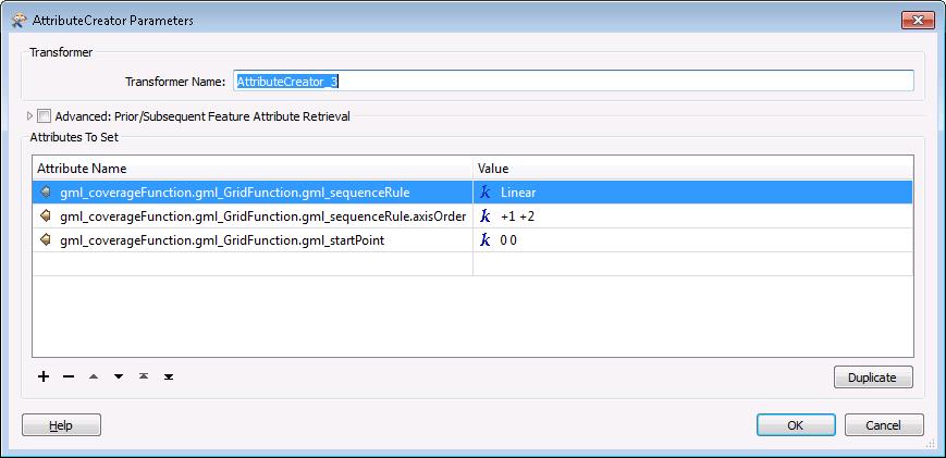
 CoverageFunction Description of grid function (ordering of file, origin point, etc.) DomainSet Description of grid nature (images coordinates, axis, resolution, etc.")
37 Orthoimageries ISO Coverages RangeType: RecordType Data values description (type of phenomenon described by the coverage, nº bits, etc.) CoverageFunction Description of grid function (ordering of file, origin point, etc.) DomainSet Description of grid nature (images coordinates, axis, resolution, etc.) RangeSet Data values (pixels values) INSPIRE OI, LC, LU raster data follows the ISO standard about Coverages. Their fundamental attributes are: INSPIRE Clusters 37
38 Orthoimageries ISO Coverages RangeSet Alternatives to encode data values: Multipart representation (OGC GML for coverages OGC r2) GML (except rangeset) + rangeset in binary format Reference to a external file GML with rangeset as gml:fileelement that points to an external file in format *.tiff, *.geotiff, etc Encoding the range inline GML with range set as gml:datablock element (all pixel values inside GML file) WCS service, where rangeset is obtained through a GetCoverage operation localized in DomainSet defined Alterative in this example INSPIRE Clusters 38
 Coverage (rangetype) needs a csvfile to define the grid bands Aggregated Mosaic Element (geometryand GML writer) XML metadata file (PNOA).")
39 Orthoimageries SHP reader (PNOA) Aggregated Mosaic Element (general att.) Coverage (rangetype) needs a csvfile to define the grid bands Aggregated Mosaic Element (geometryand GML writer) XML metadata file (PNOA). To read it FME needs a reader configuration file xfmap Coverage(general att. from the INSPIRE them) and domain extent Coverage(rangeSet, gridfunction, domainset and footprint) Coverage (geometryand GML writer) INSPIRE Clusters 39
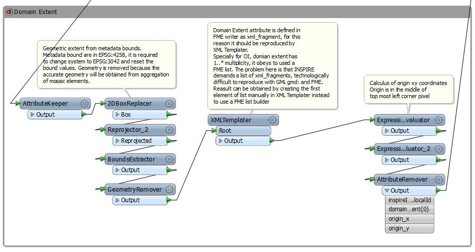

40 Orthoimageries Domain extent INSPIRE Clusters 40
41 Orthoimageries Domain extent INSPIRE Clusters 41


42 Orthoimageries Range type INSPIRE Clusters 42
43 Orthoimageries Range type INSPIRE Clusters 43
44 Orthoimageries Range type Example of values for LC/LU grid raster datasets. HRL=Copernicus High Resolution Layer, CLC=CORINE Land Cover. [ref.: EAGLE group] INSPIRE Clusters 44


45 Orthoimageries Coverage Function & metadata INSPIRE Clusters 45
46 Orthoimageries Coverage Function & metadata Example of values for LC/LU grid raster datasets. HRL=Copernicus High Resolution Layer, CLC=CORINE Land Cover. [ref.: EAGLE group] INSPIRE Clusters 46


47 Orthoimageries Domain Set INSPIRE Clusters 47
48 Orthoimageries Domain Set INSPIRE Clusters 48
49 Orthoimageries Domain Set Example of values for LC/LU grid raster datasets. HRL=Copernicus High Resolution Layer, CLC=CORINE Land Cover. [ref.: EAGLE group] INSPIRE Clusters 49

50 Orthoimageries Range Set INSPIRE Clusters 50

51 Orthoimageries Range Set INSPIRE Clusters 51
52 Orthoimageries Range Set Example of values for LC/LU grid raster datasets. HRL=Copernicus High Resolution Layer, CLC=CORINE Land Cover. [ref.: EAGLE group] INSPIRE Clusters 52
53 Open issues RangeSet by external file does not seem the best solution because is pointed to a local resource, better through a WCS Allowed file formats (tiff, geotiff, jpeg200, etc.) are not optimal for dealing with big volume grid datasets Transform grid data into INSPIRE coordinate reference system implies re-sampling the original image values Geographical grid systems are different between countries, homogenization into INSPIRE implies re-sampling the original image values INSPIRE DomainExtent for coverages generates diverse interpretation by data providers. Redundancy between GML and ISO- OGC Coverages extent attributes. INSPIRE Clusters 53

54 Result 3 OrthoimageryCoverages 7 AggregatedMosaicElements INSPIRE, GML and FME attributes, xmlfragments are showed by [ ] 2 table views INSPIRE Clusters 54
55 Presentation Conclusions INSPIRE Clusters 55
56 Conclusions FME is able to create INSPIRE GML, but needs advanced experience with XML INSPIRE themes are more distinct that expected at XSD level (possible proposal to homogenize data types, extent, geometry, dates) Open issues Mistakes in the INSPIRE XSD for Land Cover Codelists do not defined by INSPIRE implies that each data provider should publish their LC class nomenclature values at web by a on-line registry Example: European Environment Agency CORINE Land Cover Complete INSPIRE validation ISO Coverage encoding (is it sufficient pointing to a external file?) What happen if INSPIRE XSD will be changed? Will FME INSPIRE GML writer work as now? INSPIRE Clusters 56

57 Instituto Geográfico Nacional Thanks for your attention Julián Delgado Hernández Land Cover and Land Use department INSPIRE Clusters
INSPIRE Land Cover and Land Use Data Specifications
 INSPIRE Land Cover and Land Use Data Specifications Lena Hallin-Pihlatie Facilitator of the Land Cover and Land Use INSPIRE Thematic Cluster www.jrc.ec.europa.eu Serving society Stimulating innovation
Pushing implementation of European coverage data and services forward
 Pushing implementation of European coverage data and services forward Jordi Escriu jordi.escriu@icgc.cat Head of Unit / IDEC - SDI of Catalonia Facilitator INSPIRE Thematic Cluster #3 Elevation, Orthoimagery,
INSPIRE Land Cover Data Specifications to model fuel maps in Europe: the experience of the ArcFUEL LIFE+ project
 INSPIRE Land Cover Data Specifications to model fuel maps in Europe: the experience of the ArcFUEL LIFE+ project Giacomo Martirano Epsilon Italia srl Mendicino (CS), IT g.martirano@epsilon-italia.it INSPIRE
INSPIRE Thematic Cluster on Land Cover and Land Use & Feedback from implementers
 INSPIRE Thematic Cluster on Land Cover and Land Use & Feedback from implementers Lena Hallin-Pihlatie Facilitator of the LC and LU Thematic Cluster www.jrc.ec.europa.eu Serving society Stimulating innovation
Service Contract based on the restricted procedure No EEA/MDI/14/009 following a call for expression of interest EEA/SES/13/005-CEI
 Service Contract 55828 based on the restricted procedure No EEA/MDI/14/009 following a call for expression of interest EEA/SES/13/005-CEI Final Report Assistance to the EEA in the production of the new
INSPIRE Thematic Cluster on Elevation, Orthoimagery, Reference systems and Geographical grids
 INSPIRE Thematic Cluster on Elevation, Orthoimagery, Reference systems and Geographical grids Jordi Escriu - facilitator www.jrc.ec.europa.eu Serving society Stimulating innovation Supporting legislation
Solving the European Data Puzzle Simplifying INSPIRE Challenges and Usage. con terra GmbH Dipl.-Ing. Mark Döring
 Solving the European Data Puzzle Simplifying INSPIRE Challenges and Usage con terra GmbH Dipl.-Ing. Mark Döring INSPIRE Reference Projects GeoBAK 2.0 Project // INSPIRE Data & Services The Project Evolution
Application Domain Extensions definition for crowd source and Volunteer Geographic Information for smart-cities services deployment.
 Application Domain Extensions definition for crowd source and Volunteer Geographic Information for smart-cities services deployment. F. Prandi, R. de Amicis, P. Parslow, M. Ford, E. D Hondt Outlook Introduction
Spanish national plan for land observation: new collaborative production system in Europe
 ADVANCE UNEDITED VERSION UNITED NATIONS E/CONF.103/5/Add.1 Economic and Social Affairs 9 July 2013 Tenth United Nations Regional Cartographic Conference for the Americas New York, 19-23, August 2013 Item
Country Report of Spain *
 Committee of Experts on Global Geospatial Information Management Second Session New York, United Nations (UN), 13 15 de August de 2012 Country Report of Spain * * Submitted by: Mr. Antonio Arozarena, Deputy
INSPIRE Land Cover and Land Use workshop
 INSPIRE Land Cover and Land Use workshop Opening of the workshop Chair: Lena Hallin-Pihlatie, Facilitator of the Land Cover and Land Use Cluster Copernicus Land products on their way towards INSPIRE Christian
Status of implementation of the INSPIRE Directive 2016 Country Fiches. COUNTRY FICHE Spain
 Status of implementation of the INSPIRE Directive 2016 Country Fiches COUNTRY FICHE Spain Introduction... 1 1. State of Play... 2 1.1 Coordination... 2 1.2 Functioning and coordination of the infrastructure...
INSPIRE - A Legal framework for environmental and land administration data in Europe
 INSPIRE - A Legal framework for environmental and land administration data in Europe Dr. Markus Seifert Bavarian Administration for Surveying and Cadastre Head of the SDI Office Bavaria Delegate of Germany
THE OVERALL EAGLE CONCEPT
 Sentinel Hub THE OVERALL EAGLE CONCEPT GEBHARD BANKO, 30. MAY 2018, COPENHAGEN ISO TC 211, STANDARDS IN ACTION SEMINAR CONTENT Background and Motivation Criteria and Structure of Data Model Semantic decomposition
IR Requirement Article 14 Portrayal
 11 Portrayal This clause defines the rules for layers and styles to be used for portrayal of the spatial object types defined for this theme. Portrayal is regulated in Article 14 of the IRs. IR Requirement
ISO Daily 10 km Gridded Climate Dataset for Canada ( ) Data Product Specifications. Revision: A
 Data Product Specifications. Revision: A") ISO 19131 Daily 10 km Gridded Climate Dataset for Canada (1950-2012) Data Product Specifications Revision: A Data product specifications: Daily 10 km Gridded Climate Dataset for Canada (1950-2012) - Table
ISO 19131 Daily 10 km Gridded Climate Dataset for Canada (1950-2012) Data Product Specifications Revision: A Data product specifications: Daily 10 km Gridded Climate Dataset for Canada (1950-2012) - Table
INSPIRE Implementation Stories and Data Harmonization Solution Patterns at Land Management Agencies Across Europe
 INSPIRE Implementation Stories and Data Harmonization Solution Patterns at Land Management Agencies Across Europe Dean Hintz, Safe Software Sören Dupke, con terra Agenda FME & INSPIRE Consuming, Writing
Geospatial Products V8i (SELECTseries 1)
") Geospatial Products V8i (SELECTseries 1) Keith Raymond Product Manager Geospatial Desktop Products Presentation Overview What are the various products? Why would you need them? Demonstrations 2 WWW.BENTLEY.COM
Geospatial Products V8i (SELECTseries 1) Keith Raymond Product Manager Geospatial Desktop Products Presentation Overview What are the various products? Why would you need them? Demonstrations 2 WWW.BENTLEY.COM
SITMUN: Cooperating to Build Local SDIs in the Barcelona Region
 SITMUN: Cooperating to Build Local SDIs in the Barcelona Region Diputació de Barcelona Territory and Sustainability Area Territorial Information Systems Department INSPIRE CONFERENCE Barcelona, September
Estonian approach to implementation of INSPIRE directive. Sulev Õitspuu Head of Bureau of Geoinfosystems Estonian Land Board
 Estonian approach to implementation of INSPIRE directive Sulev Õitspuu Head of Bureau of Geoinfosystems Estonian Land Board 13.06.2016 Contents - INSPIRE coordination in Estonia - INSPIRE implementation
Web Portal to European Soil Database
 Web Portal to European Soil Database A step towards harmonization of Soil Information in Europe Marc Van Liedekerke, Panos Panagos, Jean Dusart Soils Portal: http://eusoils.jrc.it Data The European Soil
Ortoimagery and Elevation coverages for INSPIRE. Ing. Pavel Šidlichovský
 ZEMĚMĚŘICKÝ ÚŘAD Ortoimagery and Elevation coverages for INSPIRE Ing. Pavel Šidlichovský INSPIRE conference 2016 Content Description of source data (OI, elevation dataset ) Licenses, prices View service
Spatial Data Infrastructure Concepts and Components. Douglas Nebert U.S. Federal Geographic Data Committee Secretariat
 Spatial Data Infrastructure Concepts and Components Douglas Nebert U.S. Federal Geographic Data Committee Secretariat August 2009 What is a Spatial Data Infrastructure (SDI)? The SDI provides a basis for
INSPIRE Implementation in Estonia using ArcGIS
 INSPIRE Implementation in Estonia using ArcGIS Sulev Õitspuu Head of Bureau of Geoinfosystems Estonian Land Board 26.09.2016 Population: 1,3 million (69% Estonians) Area: 45,339 km 2 15 counties Estonia
HOW TO DEAL WITH TERRESTRIAL AND OCEANIC INFORMATION USING SDI TECHNOLOGIES
 HOW TO DEAL WITH TERRESTRIAL AND OCEANIC INFORMATION USING SDI TECHNOLOGIES Antonio F. Rodríguez Pascual 1, José Luis Sanz Alonso 2, José Ángel Alonso Jiménez 1, Paloma Abad Power 1, Alejandra Sánchez
ISO MODIS NDVI Weekly Composites for Canada South of 60 N Data Product Specification
 ISO 19131 MODIS NDVI Weekly Composites for South of 60 N Data Product Specification Revision: A Data specification: MODIS NDVI Composites for South of 60 N - Table of Contents - 1. OVERVIEW... 3 1.1. Informal
Climate Data for Non-experts: Standards-based Interoperability
 Climate Data for Non-experts: Standards-based Interoperability Ben Domenico Unidata Program Center University Corporation for Atmospheric Research April 2010 Working Together on A Mosaic for Atmospheric
Use of the ISO Quality standards at the NMCAs Results from questionnaires taken in 2004 and 2011
 Use of the ISO 19100 Quality standards at the NMCAs Results from questionnaires taken in 2004 and 2011 Eurogeographics Quality Knowledge Exchange Network Reference: History Version Author Date Comments
Implementing INSPIRE Geoportal in Turkey
 Implementing INSPIRE Geoportal in Turkey Gencay SERTER City and Regional Planner 1 Presentation Plan Introduction INSPIRE and Turkey Importance of al Spatial Planning Portal Logical&Legal Hierarchy GeoPortal
Approaches to supporting coverages and multidimensional arrays required by Annex II and III. Dean Hintz Safe Software INSPIRE 2017, Strasbourg
 Approaches to supporting coverages and multidimensional arrays required by Annex II and III Dean Hintz Safe Software INSPIRE 2017, Strasbourg Agenda Use of coverages in INSPIRE Data model representations
Bentley Map Advancing GIS for the World s Infrastructure
 Bentley Map Advancing GIS for the World s Infrastructure Presentation Overview Why would you need Bentley Map? What is Bentley Map? Where is Bentley Map Used? Why would you need Bentley Map? Because your
INSPIREd solutions for Air Quality problems Alexander Kotsev
 INSPIREd solutions for Air Quality problems Alexander Kotsev www.jrc.ec.europa.eu Serving society Stimulating innovation Supporting legislation The European data puzzle The European data puzzle 24 official
European Directive (2007/2/EC) INSPIRE sharing soil data in interoperable way
 INSPIRE sharing soil data in interoperable way") European Directive (2007/2/EC) INSPIRE sharing soil data in interoperable way EIONET Workshop on Soil, Ispra, 10 th -12 th December 2012 Robert Tomas, Ph.D European Commission Joint Research Centre Digital
European Directive (2007/2/EC) INSPIRE sharing soil data in interoperable way EIONET Workshop on Soil, Ispra, 10 th -12 th December 2012 Robert Tomas, Ph.D European Commission Joint Research Centre Digital
Leveraging the OGC Capabilities of ArcGIS Server
 Leveraging the OGC Capabilities of ArcGIS Server Satish Sankaran Interoperability and Standards Team Yingqi Tang Server Team Jessica Parteno Geodatabase Team ArcGIS Server is Open & Interoperable Using
INSPIRE. Data Specification for Meteorology. Bruce Wright, Expert Strategic Advisor (Data Management)
") INSPIRE Data Specification for Meteorology Bruce Wright, Expert Strategic Advisor (Data Management) Third Workshop on the use of GIS/OGC Standards in Meteorology- 15 November 2010 Table of Contents INSPIRE
INSPIRE Data Specification for Meteorology Bruce Wright, Expert Strategic Advisor (Data Management) Third Workshop on the use of GIS/OGC Standards in Meteorology- 15 November 2010 Table of Contents INSPIRE
D.5.1: report on user requirements for the EuroGEOSS Drought operating capacity Revised Version
 Project start date: 01 May 2009 Acronym: EuroGEOSS Project title: EuroGEOSS, a European Theme: FP7-ENV-2008-1: Environment (including climate change) Theme title: ENV.2008.4.1.1.1: European Environment
ISO Swift Current LiDAR Project 2009 Data Product Specifications. Revision: A
 ISO 19131 Swift Current LiDAR Project 2009 Data Product Specifications Revision: A Data product specifications: Swift Current LiDAR Project 2009 - Table of Contents- 1. Overview... 4 1.1. Informal description...
Implementation of INSPIRE Principles: Sardinia Region SDI State of the Art and Further Developments
 REGION OF SARDINIA (ITALY) LOCAL AUTHORITY FOR MUNICIPALITIES, FINANCES AND URBAN PLANNING DEPT. FOR THE REGIONAL SPATIAL DATA INFRASTRUCTURE Implementation of INSPIRE Principles: Sardinia Region SDI State
EAGLE concept, as part of the HELM vision
 EAGLE concept, as part of the HELM vision EAGLE working group Barbara Kosztra (Hungary), Stephan Arnold (Germany), Lena Hallin-Pihlatie & Elise Järvenpää (Finland) 16.06.2014 HELM / EAGLE Workshop - INSPIRE
ISO INTERNATIONAL STANDARD. Geographic information Metadata Part 2: Extensions for imagery and gridded data
 INTERNATIONAL STANDARD ISO 19115-2 First edition 2009-02-15 Geographic information Metadata Part 2: Extensions for imagery and gridded data Information géographique Métadonnées Partie 2: Extensions pour
2nd Joint SIG 3D and OGC Workshop - CityGML EnergyADE for building energy calculation. Working group metadata
 2nd Joint SIG 3D and OGC Workshop - CityGML EnergyADE for building energy calculation Working group metadata TOC Metadata standards for spatial data CityGML Metadata discussion at SIG3D and OGC Closer
CityGML XFM Application Template Documentation. Bentley Map V8i (SELECTseries 2)
") CityGML XFM Application Template Documentation Bentley Map V8i (SELECTseries 2) Table of Contents Introduction to CityGML 1 CityGML XFM Application Template 2 Requirements 2 Finding Documentation 2 To
CityGML XFM Application Template Documentation Bentley Map V8i (SELECTseries 2) Table of Contents Introduction to CityGML 1 CityGML XFM Application Template 2 Requirements 2 Finding Documentation 2 To
S. Nativi*, J. Caron^ and B. Domenico^ * University of Florence at Prato Piazza Ciardi, Prato Italy
 NcML-G ML : encoding NetCDF datasets using GML S. Nativi*, J. Caron^ and B. Domenico^ * University of Florence at Prato Piazza Ciardi, 25 59100 Prato Italy stefano.nativi@pin.unifi.it ^ Unidata Program
Working with OGC WCS Services - WCS in ArcGIS. Zikang Zhou
 Working with OGC WCS Services - WCS in ArcGIS Zikang Zhou zzhou@esri.com OGC WCS introduction The Open Geospatial Consortium, Inc. (OGC) Web Coverage Service (WCS) provides an open specification for sharing
The production and use of a hydrographic flow-direction network of surface waters. Rickard HALLENGREN, Håkan OLSSON and Erik SISELL, Sweden
 The production and use of a hydrographic flow-direction network of surface waters Rickard HALLENGREN, Håkan OLSSON and Erik SISELL, Sweden Key words: hydrographic, flow-direction network, surface waters
Challenges of INSPIRE & Copernicus or how to square a circle
 Challenges of INSPIRE & Copernicus or how to square a circle Barcelona, Spain Peter Strobl European Commission Joint Research Centre Peter.Strobl@ec.europa.eu with kind support by OGC s DGGS SWG, Matt
The EAGLE concept - first practical implementations. Title. Stephan Arnold. Position Gebhard Banko. Place, Copenhagen, date 20.
 The EAGLE concept - first practical implementations Title Stephan Arnold DeStatis First name SURNAME Position Gebhard Banko Environment Name of the entity Agency Austria Place, Copenhagen, date 20. October2015
Hosted by Esri Official Distributor
 Hosted by Esri Official Distributor Esri European User Conference October 15-17, 2012 Oslo, Norway Hosted by Esri Official Distributor Interoperability and Standards Support in ArcGIS 10.1 Roberto Lucchi
UK Contribution to the European CORINE Land Cover
 Centre for Landscape andwww.le.ac.uk/clcr Climate Research CENTRE FOR Landscape and Climate Research UK Contribution to the European CORINE Land Cover Dr Beth Cole Corine Coordination of Information on
Working with OGC WCS. Zikang Zhou
 Working with OGC WCS Zikang Zhou zzhou@esri.com Working with OGC WCS Introduction The Open Geospatial Consortium, Inc. (OGC) Web Coverage Service (WCS) provides an open specification for sharing coverages
The importance of persistent URIs for the implementation of INSPIRE
 The importance of persistent URIs for the implementation of INSPIRE INSPIRE Conference 2012, Istanbul Clemens Portele, interactive instruments GmbH Drafting Team Data Specifications (Chair) Directive,
THE NATIONAL ATLAS OF SPAIN ( ): FACSIMILE DIGITAL VERSION
: FACSIMILE DIGITAL VERSION") THE NATIONAL ATLAS OF SPAIN (1986-2008): FACSIMILE DIGITAL VERSION Abstract Pilar Sánchez-Ortiz Rodríguez Instituto Geográfico Nacional. Ministerio de Fomento General Ibáñez Ibero, 3 28003 Madrid (Spain)
THE NATIONAL ATLAS OF SPAIN (1986-2008): FACSIMILE DIGITAL VERSION Abstract Pilar Sánchez-Ortiz Rodríguez Instituto Geográfico Nacional. Ministerio de Fomento General Ibáñez Ibero, 3 28003 Madrid (Spain)
NAG-City Expert Workshop Oslo 8-9. October 2012 SOSI standards and mapping for Europe (INSPIRE)
") NAG-City Expert Workshop Oslo 8-9. October 2012 SOSI standards and mapping for Europe (INSPIRE) Per Ryghaug, Geomatics The Norwegian national standard on geographic information - SOSI Started in 1984 NGU
NAG-City Expert Workshop Oslo 8-9. October 2012 SOSI standards and mapping for Europe (INSPIRE) Per Ryghaug, Geomatics The Norwegian national standard on geographic information - SOSI Started in 1984 NGU
The INSPIRE compliant Geological Map of Germany 1:1,000,000 (GK1000)
") The INSPIRE compliant Geological Map of Germany 1:1,000,000 (GK1000) Marc Filip Wiechmann, Stephanie Bellenberg, Susanne Glück, Andreas Alexander Maul Federal Institute for Geosciences and Natural Resources
The INSPIRE compliant Geological Map of Germany 1:1,000,000 (GK1000) Marc Filip Wiechmann, Stephanie Bellenberg, Susanne Glück, Andreas Alexander Maul Federal Institute for Geosciences and Natural Resources
Data Aggregation with InfraWorks and ArcGIS for Visualization, Analysis, and Planning
 Data Aggregation with InfraWorks and ArcGIS for Visualization, Analysis, and Planning Stephen Brockwell President, Brockwell IT Consulting, Inc. Join the conversation #AU2017 KEYWORD Class Summary Silos
Version 1.1 GIS Syllabus
 GEOGRAPHIC INFORMATION SYSTEMS CERTIFICATION Version 1.1 GIS Syllabus Endorsed 1 Version 1 January 2007 GIS Certification Programme 1. Target The GIS certification is aimed at: Those who wish to demonstrate
NATIONAL SPATIAL DATA INFRASTRUCTURE OF SPAIN: ORGANISATIONAL & LEGAL FRAMEWORK.
 NATIONAL SPATIAL DATA INFRASTRUCTURE OF SPAIN: ORGANISATIONAL & LEGAL FRAMEWORK. ABSTRACT. Sebastian Mas-Mayoral Antonio F. Rodríguez-Pascual Instituto Geográfico Nacional (National Geographic Institute)
Data Specification Elevation v2.0
 INSPIRE DS Stream Data Specification Elevation v2.0 Jordi Escriu Paradell - TWG EL Editor Institut Cartogràfic de Catalunya (ICC) INSPIRE Conference 2011 Edinburgh, 29 th June -1 st July 2011 1 This presentation
Innovation. The Push and Pull at ESRI. September Kevin Daugherty Cadastral/Land Records Industry Solutions Manager
 Innovation The Push and Pull at ESRI September 2004 Kevin Daugherty Cadastral/Land Records Industry Solutions Manager The Push and The Pull The Push is the information technology that drives research and
Lecture 6 - Raster Data Model & GIS File Organization
 Lecture 6 - Raster Data Model & GIS File Organization I. Overview of Raster Data Model Raster data models define objects in a fixed manner see Figure 1. Each grid cell has fixed size (resolution). The
TERMS OF REFERENCE FOR PROVIDING THE CONSULTANCY SERVICES OF
 1 Cartographic Database and TM100 Product Specifications TERMS OF REFERENCE FOR PROVIDING THE CONSULTANCY SERVICES OF Production and establishment of cartographic database for scale 1:100,000 and production
INSPIRE Infrastructure for Spatial Information in Europe. D2.8.II.1 Data Specification on Elevation Technical Guidelines
 Infrastructure for Spatial Information in Europe D2.8.II.1 Data Specification on Elevation Technical Guidelines Title Creator Date 10-12-2013 Subject Publisher Type Description Contributor Format Source
To: Ross Martin, Lisa Stapleton From: Brad Lind Subject: Joint Funding Agreement with USGS for 2012 Imagery Date: March 14, 2012.
 To: Ross Martin, Lisa Stapleton From: Brad Lind Subject: Joint Funding Agreement with USGS for 2012 Imagery Date: March 14, 2012 Attached are two copies of the Joint Funding Agreement (JFA) between SanGIS
Reducing Consumer Uncertainty
 Spatial Analytics Reducing Consumer Uncertainty Eliciting User and Producer Views on Geospatial Data Quality Introduction Cooperative Research Centre for Spatial Information (CRCSI) in Australia Communicate
Features and Benefits
 Autodesk LandXplorer Features and Benefits Use the Autodesk LandXplorer software family to help improve decision making, lower costs, view and share changes, and avoid the expense of creating physical
Display data in a map-like format so that geographic patterns and interrelationships are visible
 Vilmaliz Rodríguez Guzmán M.S. Student, Department of Geology University of Puerto Rico at Mayagüez Remote Sensing and Geographic Information Systems (GIS) Reference: James B. Campbell. Introduction to
All About Spatial Data. Find it, Manage it, Use it
 All About Spatial Data Find it, Manage it, Use it Workshop Outline Define spatial data Spatial data formats Data Sources Metadata Evaluating Spatial Data Data Management Activities: define spatial data,
Questions and Answers
 AUTODESK LANDXPLORER SOFTWARE FAMILY Questions and Answers The Autodesk LandXplorer 3D city model software family can help you create, analyze, and visualize digital city models. Contents Autodesk Landxplorer
Validation and verification of land cover data Selected challenges from European and national environmental land monitoring
 Validation and verification of land cover data Selected challenges from European and national environmental land monitoring Gergely Maucha head, Environmental Applications of Remote Sensing Institute of
INSPIRE implementation in Portugal: the operational approach
 INSPIRE implementation in Portugal: the operational approach REIS, Rui; SANTOS, Ana Sofia; FONSECA, Alexandra; SILVA, Henrique; GOMES, Ana Luisa; FURTADO, Danilo; GEIRINHAS, João rui.reis@igeo.pt AGENDA
SPANISH GOOD (AND NO SO GOOD) PRACTICES IMPLEMENTING INSPIRE
 PRACTICES IMPLEMENTING INSPIRE") SPANISH GOOD (AND NO SO GOOD) PRACTICES IMPLEMENTING INSPIRE HELLO! I am Emilio López I am here because I am the Director of the National Centre for Geographic Information You can find me at elromero@fomento.es
SPANISH GOOD (AND NO SO GOOD) PRACTICES IMPLEMENTING INSPIRE HELLO! I am Emilio López I am here because I am the Director of the National Centre for Geographic Information You can find me at elromero@fomento.es
The EAGLE Concept - Paving the way for a new European Land Monitoring System
 The EAGLE Concept - Paving the way for a new European Land Monitoring System Stephan Arnold, Barbara Kosztra, Gebhard Banko, Geoff Smith, Christoph Perger, Michael Bock, Geir-Harald Strand, Cesar Martinez,
The contribution of EUREF to Inspire
 EUREF2010 SYMPOSIUM The contribution of EUREF to Inspire J. Torres, V. Bitenc, A. Caporali, P. Cruddace, L. Engberg, B. Garayt and H. Habrich (members of TWG-RS) June 2-4, 2010 Gävle 1 EUREF2010 SYMPOSIUM
SDI-Challenges European perspective
 THE HIGH LEVEL FORUM ON GLOBAL GEOSPATIAL INFORMATION MANAGEMENT Seoul, Republic of Korea, 24-26 October 2011 Session 1: Challenges in geospatial policy formation and institutional arrangements SDI-Challenges
ISO Land Use 1990, 2000, 2010 Data Product Specifications. Revision: A
 ISO 19131 Land Use 1990, 2000, 2010 Data Product Specifications Revision: A Contents 1 OVERVIEW... 3 1.1 Informal description... 3 1.2 Data product specifications Metadata... 3 1.3 Terms and Definitions...
Atmospheric Science and GIS Interoperability issues: some Data Model and Computational Interface aspects
 UNIDATA Boulder, Sep. 2003 Atmospheric Science and GIS Interoperability issues: some Data and Computational Interface aspects Stefano Nativi University of Florence and IMAA-CNR Outline Service-Oriented
An Introduction to the Community Maps Information Model
 Esri International User Conference July 23 27 San Diego Convention Center An Introduction to the Community Maps Information Model Seth Sarakaitis Agenda Overview of Community Maps Program Information Models
Technical Framework Methodology as a core of building up the NSDI NSDI Implementation Specifics in Serbia
 Technical Framework Methodology as a core of building up the NSDI NSDI Implementation Specifics in Serbia Luka Jovičić SDI Consultant@ Gramont Ltd. Aleksandar Dedić RGA NSDI department Dragica Pajić RGA
Towards a harmonised land monitoring system: NRC bottom-up activities in EAGLE and HELM H
 B. Kosztra Towards a harmonised land monitoring system: NRC bottom-up activities in EAGLE and HELM H Gebhard Banko Environment Agency Austria Geoland 2 Forum 18.-19. October 2012 Copenhagen 1 1 NRC * opinion
Managing Imagery and Raster Data Using Mosaic Datasets
 Esri International User Conference San Diego, California Technical Workshops July 25, 2012 Managing Imagery and Raster Data Using Mosaic Datasets Hong Xu, Prashant Mangtani Presentation Overview Introduction
The PREVIEW Global Risk Data Platform: a geoportal to serve and share global data on risk to natural hazards
 The PREVIEW Global Risk Data Platform: a geoportal to serve and share global data on risk to natural hazards Gregory Giuliani (UNEP/GRID-Geneva & University of Geneva/enviroSPACE ) http://www.grid.unep.ch
Paper UC1351. Conference: User Conference Date: 08/10/2006 Time: 8:30am-9:45am Room: Room 23-B (SDCC)
") Conference: User Conference Date: 08/10/2006 Time: 8:30am-9:45am Room: Room 23-B (SDCC) Title of Paper: Increasing the Use of GIS in the Federal Government Author Name: Miss Abstract This presentation
Conference: User Conference Date: 08/10/2006 Time: 8:30am-9:45am Room: Room 23-B (SDCC) Title of Paper: Increasing the Use of GIS in the Federal Government Author Name: Miss Abstract This presentation
CHAPTER 7 PRODUCT USE AND AVAILABILITY
 CHAPTER 7 PRODUCT USE AND AVAILABILITY Julie Prior-Magee Photo from SWReGAP Training Site Image Library Recommended Citation Prior-Magee, J.S. 2007. Product use and availability. Chapter 7 in J.S. Prior-Magee,
SPOT DEM Precision Product description
 SPOT DEM Precision Product description Version1.0 - April 1st, 2006 This edition supersedes previous versions Acronyms DIMAP DTED DXF HRS JPEG, JPG Mb DTM DEM SRTM SVG TIFF - GeoTIFF XML Digital Image
INTEROPERABILITY AND DATA HOMOGENIZATION
 Page 1 of 5 The Transnational Geo-portal Italian-Slovenian of the Cross-Border Park Area Eva Savina Malinverni DARDUS Università Politecnica delle Marche Ancona, IT e.s.malinverni@univpm.it INTRODUCTION
Horizontal Interoperability among National Geoportals of ES, FR, PT & AD
 Horizontal Interoperability among National Geoportals of ES, FR, PT & AD A. F. Rodríguez S. Mas, D. Richard, J. M. Nataf, D. Furtado, R. P. Julião, S. Pijuan, S. Alba 1 Next 15 minutes Intoduction 4 National
Land Monitoring Core Service Implementation Group (LMCS IG) - Results and Outlook
 - Results and Outlook") Land Monitoring Core Service Implementation Group (LMCS IG) - Results and Outlook Pr. Dietmar Grünreich, President of BKG, Germany Chairman of the GMES LMCS IG Outline 1 Introduction 2 Preparatory Projects
Land Monitoring Core Service Implementation Group (LMCS IG) - Results and Outlook Pr. Dietmar Grünreich, President of BKG, Germany Chairman of the GMES LMCS IG Outline 1 Introduction 2 Preparatory Projects
Finding geodata that otherwise would have been forgotten GeoXchange a portal for free geodata
 Finding geodata that otherwise would have been forgotten GeoXchange a portal for free geodata Sven Tschirner and Alexander Zipf University of Applied Sciences FH Mainz Department of Geoinformatics and
Using OGC standards to improve the common
 Using OGC standards to improve the common operational picture Abstract A "Common Operational Picture", or a, is a single identical display of relevant operational information shared by many users. The
INSPIRE General Introduction & Service Architecture
 INSPIRATION Spatial Data Infrastructure in the Western Balkans INSPIRE General Introduction & Service Architecture 1st National INSPIRATION Workshop Croatia November 21-22, 2012 A multi-countryprojectfunded
ArcGIS for INSPIRE. Marten Hogeweg
 ArcGIS for INSPIRE Marten Hogeweg Please Take Our Survey on the App Download the Esri Events app and find your event Select the session you attended Scroll down to find the feedback section Complete answers
Geography 38/42:376 GIS II. Topic 1: Spatial Data Representation and an Introduction to Geodatabases. The Nature of Geographic Data
 Geography 38/42:376 GIS II Topic 1: Spatial Data Representation and an Introduction to Geodatabases Chapters 3 & 4: Chang (Chapter 4: DeMers) The Nature of Geographic Data Features or phenomena occur as
Regione Umbria. ESRI EMEA User Conference 2010 Rome, October 27th 2010
 Direzione Ambiente, Territorio e Infrastrutture Servizio Informatico/Informativo: geografico, ambientale e territoriale ESRI EMEA User Conference 2010 Rome, October 27th 2010 Arch. Ambra Ciarapica, Dott.
Implementing INSPIRE in Sweden
 Implementing INSPIRE in Sweden Christina Wasström NSDI-unit, Lantmäteriet Christina.wasstrom@lm.se Standards Cooperation Metadata Competence Infrastructure for Geodata Legal Framework Portal Services Geodata
The File Geodatabase API. Craig Gillgrass Lance Shipman
 The File Geodatabase API Craig Gillgrass Lance Shipman Schedule Cell phones and pagers Please complete the session survey we take your feedback very seriously! Overview File Geodatabase API - Introduction
Subwatersheds File Geodatabase Feature Class
 Subwatersheds File Geodatabase Feature Class Tags subwatersheds, watersheds Summary shows the subwatersheds of the 9 watersheds in TRCA's jurisdiction Description sub watershed boundaries in TRCA jurisdiction.
ISO Canadian Drought Monitor Data Product Specifications
 ISO 19131 Canadian Drought Monitor Data Product Specifications Revision: A Page 1 of 14 Data product specifications: Canadian Drought Monitor - Table of Contents- 1. Overview... 3 1.1. Informal description...
INSPIRE Thematic Cluster on Topographic and Cadastral Reference data
 INSPIRE Thematic Cluster on Topographic and Cadastral Reference data Anja Hopfstock - facilitator www.jrc.ec.europa.eu Serving society Stimulating innovation Supporting legislation Status of Thematic cluster
Assessing the Robustness of Web Feature Services Necessary to Satisfy the Requirements of Coastal Management
 Assessing the Robustness of Web Feature Services Necessary to Satisfy the Requirements of Coastal Management Jennifer Bauer M.S. Geography GISci Certificate June 4, 2012 Presentation Outline!! Background
3nd Joint SIG 3D and OGC Workshop - CityGML EnergyADE for building energy calculation. Working group metadata
 3nd Joint SIG 3D and OGC Workshop - CityGML EnergyADE for building energy calculation Working group metadata Part I Three Approaches Questions to keep in mind Should metadata in CityGML be close to ISO