THE OVERALL EAGLE CONCEPT
|
|
|
- Rosa Short
- 5 years ago
- Views:
Transcription


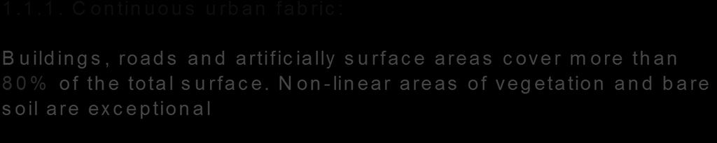
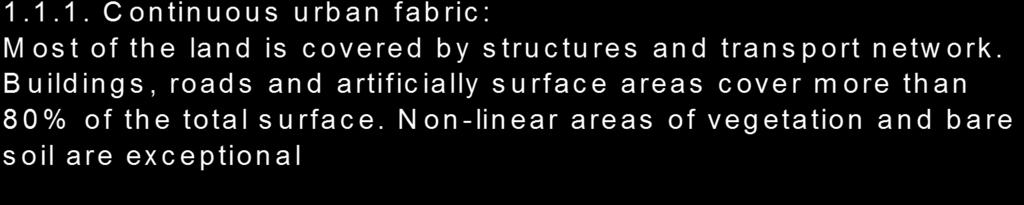
1 Sentinel Hub THE OVERALL EAGLE CONCEPT GEBHARD BANKO, 30. MAY 2018, COPENHAGEN ISO TC 211, STANDARDS IN ACTION SEMINAR
2 CONTENT Background and Motivation Criteria and Structure of Data Model Semantic decomposition EAGLE documentation & tools Summary 2 SEMINAR: STANDARDS IN ACTION EAGLE PRINCIPLES
3 BACKGROUND AND MOTIVATION Many applications of LC/LU data lead to various different classification systems (on national, European & International level) Effects : Mixture of LC and LU classes Specific fields of work have own emphasis on thematic categories Lack of comparability between nomenclatures hamper exchange of information between data sets 3 SEMINAR: STANDARDS IN ACTION EAGLE PRINCIPLES
4 WHO AND WHAT IS EAGLE? EAGLE = EIONET Action Group on Land Monitoring in Europe Participants are National Land Monitoring experts and Representatives of National Reference Centres (NRC) for Land Cover in the EEA s EIONET (European Environmental Information and Observation Network) Established in 2009 as self-initiative Focus on object-oriented data modelling of LC & LU Open membership based on own commitment Firstly no external funding, meanwhile supported by COPERNICUS/EEA funding. 4 SEMINAR: STANDARDS IN ACTION EAGLE PRINCIPLES
5 CRITERIA FOR LC & LU DATA MODEL Clear separation between LC and LU Scale independent Object-oriented description additional to classification Complete coverage of themes LC and LU Modelling of temporal phenomena Applicable on national & European & International level 5 SEMINAR: STANDARDS IN ACTION EAGLE PRINCIPLES


6 DE-COMPOSITION OF LANDSCAPE From classification to object-oriented description SEMINAR: STANDARDS IN ACTION EAGLE PRINCIPLES Fotos: Copyright Ursus Wehrli

7 De-Composition of CORINE Land Cover classes LC LU CH Parameter SEMINAR: STANDARDS IN ACTION EAGLE PRINCIPLES
8 STRUCTURE OF THE EAGLE MATRIX & MODEL Information on landscape described with three separate blocks: APPLICABLE either on class-level or object level!!! IMPORTANT: controlled vocabulary (predefined classes) presentation by S. Arnold Defined semantic concepts I.) LAND COVER Components LCC Abiotic (Artificial + Natural), Vegetation, Water Surfaces II.) LAND USE Attributes LUA Agriculture, Forestry, Residential, Transportation etc. III.) CHARACTERISTICS CH coverage, spatial pattern, bio-physical parameters, cultivation measures, land management practices, status/condition etc. 8 SEMINAR: STANDARDS IN ACTION EAGLE PRINCIPLES
 121 M. Bock, B.")
9 APPLICATION OF LAND COVER COMPONENTS Agro-industrial production site In CLC classified with one class-label CLC-Code = 121 (industrial site) 121 M. Bock, B. Kosztra 9 SEMINAR: STANDARDS IN ACTION EAGLE PRINCIPLES
 Attaching more than 1 LCC to the unit M. Bock, B.")
10 APPLICATION OF LAND COVER COMPONENTS Description óf land cover composition for each object (single land surface unit) Attaching more than 1 LCC to the unit M. Bock, B. Kosztra 10 SEMINAR: STANDARDS IN ACTION EAGLE PRINCIPLES

11 APPLICATION OF LAND COVER COMPONENTS Describing land objects with COUNT and PERCENTAGE cover values of each LCC M. Bock, B. Kosztra 11 SEMINAR: STANDARDS IN ACTION EAGLE PRINCIPLES

12 DETERMINING SPATIAL REFERENCE OBJECTS Polygons: single objects, distinct feature types, Grid cells: descriptive characterization, standardized spatial reference unit M. Bock SEMINAR: STANDARDS IN ACTION EAGLE PRINCIPLES
: Soil sealing degree = 35% Built-up pattern = discontinuous, single houses Agricultural measure: Mowing B.")
13 EXAMPLE: RURAL SETTLEMENT Land cover components (LCC): Conventional buildings Trees, broad leaved Herbaceous plants Open sealed surfaces Land use attributes (LUA): Permanent residantial Agriculture; own consumption Road transportation network Further characteristics (CH): Soil sealing degree = 35% Built-up pattern = discontinuous, single houses Agricultural measure: Mowing B. Kosztra SEMINAR: STANDARDS IN ACTION EAGLE PRINCIPLES
14 TWO APPLICATION DOMAINS OF EAGLE DATA MODEL Object oriented data model is applicable for 2 main approaches Tool for semantic comparison of definitions between different classification systems or single classes Onthologie based reasoning Guideline for descriptive characterization of landscape objects for data collection and future mapping initiatives data model in line with INSPIRE LC model 14 SEMINAR: STANDARDS IN ACTION EAGLE PRINCIPLES

15 EAGLE UML MODEL UML Description UML graphs UML Application schema web version Enterprise Architect version 15 SEMINAR: STANDARDS IN ACTION EAGLE PRINCIPLES

16 INTEGRATION OF DATA: INFORMAL DATA MODEL SEMINAR: STANDARDS IN ACTION EAGLE PRINCIPLES
17 CHANGES IN LANDMONITORING Three main type of changes Temporal profiles and temporal vectors Data model has to handle different types of temporal dynamics Status changes Seasonal changes Conditional changes Growth, succcession Deforestation, Soil sealing growth harvest growth, succession Drought stress, climate, incsects Urban succession SEMINAR: STANDARDS IN ACTION EAGLE PRINCIPLES
 using full time series SEMINAR: STANDARDS IN ACTION EAGLE")
18 Sentinel-2: Paradigm Change From semi-automatic CORINE landcover, HR land cover products (20x20m) to operational, fully automatic S2 land monitoring services (10x10m) using full time series SEMINAR: STANDARDS IN ACTION EAGLE PRINCIPLES


19 EAGLE DATA MODEL TIME MACHINE Wihtin 1 LC-unit more than 1 LC component can exist over time (seasonal changes) validfrom: Date validto: Date 19 SEMINAR: STANDARDS IN ACTION EAGLE PRINCIPLES
20 Temporal profile of one LC unit (arable field) Parametric observation SEMINAR: STANDARDS IN ACTION EAGLE PRINCIPLES
21 Temporal sequence of LC components within a LC Unit bare soil Herbeceous veg. bare soil Herbeceous veg. bare soil LCcomponent Parametric observation SEMINAR: STANDARDS IN ACTION EAGLE PRINCIPLES
22 Herbeceous periodically. LC-Unit bare soil Herbeceous veg. bare soil Herbeceous veg. bare soil LCcomponent Parametric observation SEMINAR: STANDARDS IN ACTION EAGLE PRINCIPLES

23 SEMINAR: STANDARDS IN ACTION EAGLE PRINCIPLES


24 Wheat vegetation cycle 1. April 1. June 15. July 1. Sept. 15. April 15. June 1. Aug. 15. Sept. 15. May 1. July 15. Aug. 1. Oct. SEMINAR: STANDARDS IN ACTION EAGLE PRINCIPLES
25 NDVI 0,9 0,8 Wheat 0,7 0,6 0,5 0,4 Wheat 0,3 0,2 0,1 Harvest: 6. July 0, SEMINAR: STANDARDS IN ACTION EAGLE PRINCIPLES
26 NDVI 0,9 Herbeceous periodically. Wheat LC-Unit 0,8 Bare soil Herbaceous vegetation Bare soil Herb. Veg. LC-component 0,7 0,6 0,5 Parametric observation 0,4 Wheat 0,3 0,2 0,1 0, SEMINAR: STANDARDS IN ACTION EAGLE PRINCIPLES

27 Parametric observation: NDVI LC components LC Unit SEMINAR: STANDARDS IN ACTION EAGLE PRINCIPLES
28 DOCUMENTATION AND TOOLS EAGLE website: Online tool: EMPACT - EAGLE Matrix population and comparison tool Technical EAGLE Matrix tool (EXCEL) EAGLE UML model PostGIS 2.0 database ESRI database & Query tool 28 SEMINAR: STANDARDS IN ACTION EAGLE PRINCIPLES
29 USE CASES OF EAGLE CONCEPT European wide application COPERNICUS: development of 2nd generation CORINE Land Cover CLC-backbone, CLC-Core, CLC+ National applications Hungary: bottom-up CLC generation (generalisation from national classes using EAGLE concept) Germany: land surveying authorities: Semantic Analysis of the Feature Type Catalogue Recent Land Use, preparations for separate land cover module Rhineland-Palatinate [DE]: NatFlo, Ministry of Environment: Remote sensing based landscape objects for nature protection and habitat database North-Rhine-Westfalia Environmental Agency: NUMO NRW, Nature and Environmental Monitoring for multi-purpose reporting Spain: SIOSE object oriented data model as successor to EAGLE Austria: LISA Land Information System Austria, Onthology based reasoning of CLC using LISA-classes Scientific applications IIASA: Comparison of OpenStreetMap land use types with EAGLE 29 SEMINAR: STANDARDS IN ACTION EAGLE PRINCIPLES
 EAGLE LCC 30 SEMINAR: STANDARDS IN ACTION EAGLE")
30 EXAMPLE FOR EAGLE LAND COVER COMPONENTS (LCC) Transformation of LISA classes (Land Inofrmation System Austria) EAGLE LCC 30 SEMINAR: STANDARDS IN ACTION EAGLE PRINCIPLES
 > Application Schema: >> EAGLELandCoverVector >")
31 EXAMPLE FROM UML-MODEL: ABIOTIC VEGETATION > Documentation and tools > semantic topics > EAGLE data model > UML application schema (web browser) > Application Schema: >> EAGLELandCoverVector > >>EAGLELandCoverVector_LCComponents >>>>Abiotic/Non-Vegetated 31 SEMINAR: STANDARDS IN ACTION EAGLE PRINCIPLES
32 SUMMARY The Eagle concept Instrument for semantic analysis, comparison, transformation and harmonisation of class definitions & systems, can provide flexible framework for future mapping initiatives -> CLC+ helps to avoid redundant data capture, applicable on raster, grid or polygon data, follows principle of integrating bottom-up / top-down approach in the European land monitoring process and is INSPIRE compliant, supported by EEA (European Environment Agency), observed by Eurostat Perceiving that EAGLE and LCML follow very similar basic concepts (using different technical approaches), a reasonable strategy would be to merge the two systems in a next version of the ISO standard 32 SEMINAR: STANDARDS IN ACTION EAGLE PRINCIPLES

33 These are the EAGLE brains....thank you for your attention SEMINAR: STANDARDS IN ACTION EAGLE PRINCIPLES
34 CONTACT & INFORMATION Gebhard Banko Umweltbundesamt ISO TC 211 Seminar: Standards in Action Copenhagen 30. May SEMINAR: STANDARDS IN ACTION EAGLE PRINCIPLES
The EAGLE Concept - Paving the way for a new European Land Monitoring System
 The EAGLE Concept - Paving the way for a new European Land Monitoring System Stephan Arnold, Barbara Kosztra, Gebhard Banko, Geoff Smith, Christoph Perger, Michael Bock, Geir-Harald Strand, Cesar Martinez,
The LISA extension to INSPIRE LC/LU data model: The Austrian experience
 The LISA extension to INSPIRE LC/LU data model: The Austrian experience Gebhard Banko, Environment Agency Austria Roland Grillmayer, Environment Agency Austria Wolfgang Stemberger, GeoVille INSPIRE KEN
Towards a harmonised land monitoring system: NRC bottom-up activities in EAGLE and HELM H
 B. Kosztra Towards a harmonised land monitoring system: NRC bottom-up activities in EAGLE and HELM H Gebhard Banko Environment Agency Austria Geoland 2 Forum 18.-19. October 2012 Copenhagen 1 1 NRC * opinion
EAGLE concept, as part of the HELM vision
 EAGLE concept, as part of the HELM vision EAGLE working group Barbara Kosztra (Hungary), Stephan Arnold (Germany), Lena Hallin-Pihlatie & Elise Järvenpää (Finland) 16.06.2014 HELM / EAGLE Workshop - INSPIRE
EAGLE data model for land monitoring - Use cases and state of play
 EAGLE data model for land monitoring - Use cases and state of play Stephan Arnold, Barbara Kosztra, Gebhard Banko, Geoff Smith, Christoph Perger, Michael Bock, Geir-Harald Strand, Cesar Martinez, Julian
EAGLE Data Model and Outcomes of HELM (Harmonised European Land Monitoring)
") EAGLE Data Model and Outcomes of HELM (Harmonised European Land Monitoring) Contribution towards better land information harmonisation and INSPIRE compliance EAGLE working group Stephan Arnold, Barbara
EAGLE Data Model and Outcomes of HELM (Harmonised European Land Monitoring) Contribution towards better land information harmonisation and INSPIRE compliance EAGLE working group Stephan Arnold, Barbara
State-of-play... The EAGLE concept conceptual basis for a future European Land Monitoring Framework
 State-of-play... The EAGLE concept conceptual basis for a future European Land Monitoring Framework Stephan Arnold, Geir-H. Strand, Barbara Kosztra, Tomas Soukup, Gebhard Banko, Gerard Hazeu, Geoff Smith,
The EAGLE concept - first practical implementations. Title. Stephan Arnold. Position Gebhard Banko. Place, Copenhagen, date 20.
 The EAGLE concept - first practical implementations Title Stephan Arnold DeStatis First name SURNAME Position Gebhard Banko Environment Name of the entity Agency Austria Place, Copenhagen, date 20. October2015
EAGLE Data Model and Outcomes of HELM (Harmonised European Land Monitoring)
") EAGLE Data Model and Outcomes of HELM (Harmonised European Land Monitoring) Contribution towards better land information harmonisation and INSPIRE compliance EAGLE working group Stephan Arnold, Barbara
EAGLE Data Model and Outcomes of HELM (Harmonised European Land Monitoring) Contribution towards better land information harmonisation and INSPIRE compliance EAGLE working group Stephan Arnold, Barbara
The EAGLE-Concept. A Data Model for Future Land Monitoring
 The EAGLE-Concept A Data Model for Future Land Monitoring Stephan Arnold, Barbara Kosztra, Geir-Harald Strand, Gebhard Banko, Lena Hallin-Pihlatie, Geoff Smith, Chris Perger, Julian Delgado EAGLE Group
Validation and verification of land cover data Selected challenges from European and national environmental land monitoring
 Validation and verification of land cover data Selected challenges from European and national environmental land monitoring Gergely Maucha head, Environmental Applications of Remote Sensing Institute of
UK Contribution to the European CORINE Land Cover
 Centre for Landscape andwww.le.ac.uk/clcr Climate Research CENTRE FOR Landscape and Climate Research UK Contribution to the European CORINE Land Cover Dr Beth Cole Corine Coordination of Information on
Applied spatial data for sustainable development strategy in Germany
 Applied spatial data for sustainable development strategy in Germany Stephan Arnold Areal Statistics, Federal Statistical Office, Germany Federal Statistical Office Headquarter: Wiesbaden Branch Office:
Copernicus for Statistics
 Copernicus for Statistics Stephan Arnold Areal statistics, Federal Statistical Office Thomas Wiatr Remote sensing, Federal Agency for Cartography and Geodesy Content Requirements and Setting Eurostat s
LAND COVER CHANGES IN ROMANIA BASED ON CORINE LAND COVER INVENTORY
 LAND COVER CHANGES IN ROMANIA BASED ON CORINE LAND COVER INVENTORY 1990 2012 JENICĂ HANGANU, ADRIAN CONSTANTINESCU * Key-words: CORINE Land Cover inventory, Land cover changes, GIS. Abstract. From 1990
Spanish national plan for land observation: new collaborative production system in Europe
 ADVANCE UNEDITED VERSION UNITED NATIONS E/CONF.103/5/Add.1 Economic and Social Affairs 9 July 2013 Tenth United Nations Regional Cartographic Conference for the Americas New York, 19-23, August 2013 Item
INSPIRE Thematic Cluster on Land Cover and Land Use & Feedback from implementers
 INSPIRE Thematic Cluster on Land Cover and Land Use & Feedback from implementers Lena Hallin-Pihlatie Facilitator of the LC and LU Thematic Cluster www.jrc.ec.europa.eu Serving society Stimulating innovation
INSPIRE Land Cover and Land Use Data Specifications
 INSPIRE Land Cover and Land Use Data Specifications Lena Hallin-Pihlatie Facilitator of the Land Cover and Land Use INSPIRE Thematic Cluster www.jrc.ec.europa.eu Serving society Stimulating innovation
Copernicus Land HRL Imperviousness: 2012 dataset, indicator Title
 Copernicus Land HRL Imperviousness: 2012 dataset, 06-09 indicator and outlook Title 2015+ Tobias LANGANKE First name SURNAME Project manager, Copernicus Position land services Name European of the Environment
SIF_7.1_v2. Indicator. Measurement. What should the measurement tell us?
 Indicator 7 Area of natural and semi-natural habitat Measurement 7.1 Area of natural and semi-natural habitat What should the measurement tell us? Natural habitats are considered the land and water areas
INSPIRE Land Cover and Land Use workshop
 INSPIRE Land Cover and Land Use workshop Opening of the workshop Chair: Lena Hallin-Pihlatie, Facilitator of the Land Cover and Land Use Cluster Copernicus Land products on their way towards INSPIRE Christian
Land accounting perspective on water resources management
 European Water 60: 161-166, 2017. 2017 E.W. Publications Land accounting perspective on water resources management G.T. Paschos, G.E. Bariamis * and E.A. Baltas Department of Water Resources and Environmental
Discussion paper on spatial units
 Discussion paper on spatial units for the Forum of Experts in SEEA Experimental Ecosystem Accounting 2018 Version: 8 June 2018 Prepared by: SEEA EEA Revision Working Group 1 on spatial units (led by Sjoerd
Technical specifications for implementation of a new land-monitoring concept based on EAGLE
 EEA/IDM/R0/17/003 Technical specifications for implementation of a new land-monitoring concept based on EAGLE D4: Draft design concept and CLC-Backbone and CLC-Core technical specifications, including
Compact guides GISCO. Geographic information system of the Commission
 Compact guides GISCO Geographic information system of the Commission What is GISCO? GISCO, the Geographic Information System of the COmmission, is a permanent service of Eurostat that fulfils the requirements
Technical specifications for implementation of a new land-monitoring concept based on EAGLE
 EEA/IDM/R0/17/003 Technical specifications for implementation of a new land-monitoring concept based on EAGLE D4: Draft design concept and CLC-Backbone and CLC-Core technical specifications, including
Land Monitoring Core Service Implementation Group (LMCS IG) - Results and Outlook
 - Results and Outlook") Land Monitoring Core Service Implementation Group (LMCS IG) - Results and Outlook Pr. Dietmar Grünreich, President of BKG, Germany Chairman of the GMES LMCS IG Outline 1 Introduction 2 Preparatory Projects
Land Monitoring Core Service Implementation Group (LMCS IG) - Results and Outlook Pr. Dietmar Grünreich, President of BKG, Germany Chairman of the GMES LMCS IG Outline 1 Introduction 2 Preparatory Projects
Problems arising during the implementation of CLC2006
 Problems arising during the implementation of CLC2006 George Büttner, Barbara Kosztra ETC-LUSI / FÖMI (HU) EIONET WG meeting on Land Monitoring IGN Portugal, 10-12 March 2010 Contents of presentation Present
System of Environmental-Economic Accounting. Advancing the SEEA Experimental Ecosystem Accounting. Extent Account (Levels 1 and 2)
") Advancing the SEEA Experimental Ecosystem Accounting Extent Account (Levels 1 and 2) Overview: The Extent Account 1. Learning objectives 2. Review of Level 0 (5m) What is it? Why do we need it? What does
Advancing the SEEA Experimental Ecosystem Accounting Extent Account (Levels 1 and 2) Overview: The Extent Account 1. Learning objectives 2. Review of Level 0 (5m) What is it? Why do we need it? What does
Pilot studies on the provision of harmonized land use/land cover statistics: Synergies between LUCAS and the national systems
 1 Pilot studies on the provision of harmonized land use/land cover statistics: Synergies between LUCAS and the national systems Norway Erik Engelien Division for Natural resources and Environmental Statistics,
ISO MODIS NDVI Weekly Composites for Canada South of 60 N Data Product Specification
 ISO 19131 MODIS NDVI Weekly Composites for South of 60 N Data Product Specification Revision: A Data specification: MODIS NDVI Composites for South of 60 N - Table of Contents - 1. OVERVIEW... 3 1.1. Informal
INSPIRE Land Cover Data Specifications to model fuel maps in Europe: the experience of the ArcFUEL LIFE+ project
 INSPIRE Land Cover Data Specifications to model fuel maps in Europe: the experience of the ArcFUEL LIFE+ project Giacomo Martirano Epsilon Italia srl Mendicino (CS), IT g.martirano@epsilon-italia.it INSPIRE
Technical specifications for implementation of a new land-monitoring concept based on EAGLE
 EEA/IDM/R0/17/003 Technical specifications for implementation of a new land-monitoring concept based on EAGLE D3: Draft design concept and CLC-Backbone, CLC-Core technical specifications, including requirements
C o p e r n i c u s L a n d M o n i t o r i n g S e r v i c e
 C o p e r n i c u s L a n d M o n i t o r i n g S e r v i c e Submodule D: stability of protected areas & related pressures: Natura2000 sites Copernicus EU Copernicus EU Copernicus EU www.copernicus.eu
Object based modelling of habitats with EO data: Semantic and technical challenges to achieve interoperability
 Object based modelling of habitats with EO data: Semantic and technical challenges to achieve interoperability Michael Bock, DLR Space Agency 1.07.2010 Folie 1 Vortrag > Autor > Dokumentname > 09.11.2005
GISCO Working Party Meeting. 8 March 2012 Luxembourg. The ESPON 2013 Programme: State of Affairs. Marjan van Herwijnen project expert in the ESPON CU
 GISCO Working Party Meeting 8 March 2012 Luxembourg The ESPON 2013 Programme: State of Affairs Marjan van Herwijnen project expert in the ESPON CU The ESPON 2013 Programme Role in Structural Funds 2007-2013:
Multifunctional theory in agricultural land use planning case study
 Multifunctional theory in agricultural land use planning case study Introduction István Ferencsik (PhD) VÁTI Research Department, iferencsik@vati.hu By the end of 20 th century demands and expectations
INSPIREd solutions for Air Quality problems Alexander Kotsev
 INSPIREd solutions for Air Quality problems Alexander Kotsev www.jrc.ec.europa.eu Serving society Stimulating innovation Supporting legislation The European data puzzle The European data puzzle 24 official
L A N D C O P E R N I C U S. Den Haag, Land Monitoring
 C O P E R N I C U S M O N I T O R I N G L A N D S E R V I C E Den Haag, 13.06.2018 hans.dufourmont@eea.europa.eu W A A R O M EEN C O P E R N I C U S L A N D M O N I T O R I N G D I E N S T? C O P E R N
CORINE LAND COVER CROATIA
 CORINE LAND COVER CROATIA INTRO Primary condition in making decisions directed to land cover and natural resources management is presence of knowledge and high quality information about biosphere and its
Habitats habitat concept, identification, methodology for habitat mapping, organization of mapping
 Habitats habitat concept, identification, methodology for habitat mapping, organization of mapping Rastislav Lasák & Ján Šeffer Training Implementation of Habitats Directive - Habitats and Plants 1 What
ISO Canadian Drought Monitor Data Product Specifications
 ISO 19131 Canadian Drought Monitor Data Product Specifications Revision: A Page 1 of 14 Data product specifications: Canadian Drought Monitor - Table of Contents- 1. Overview... 3 1.1. Informal description...
Historical Assessment of Spatial Growth of Built-ups and Metropolitan areas of Delhi and Mumbai in India and Dhaka in Bangladesh
 Historical Assessment of Spatial Growth of Built-ups and Metropolitan areas of Delhi and Mumbai in India and Dhaka in Bangladesh Tomas Soukup, GISAT World Bank HQ, Washington DC Date : 12 April 2011 Introduction
LUCAS: current product and its evolutions
 LUCAS: current product and its evolutions Workshop Land Use and Land Cover products: challenges and opportunities Brussels 15 Nov 2017 Eurostat E4: estat-dl-lucas@ec.europa.eu Contents 1) The context 2)
Service Contract based on the restricted procedure No EEA/MDI/14/009 following a call for expression of interest EEA/SES/13/005-CEI
 Service Contract 55828 based on the restricted procedure No EEA/MDI/14/009 following a call for expression of interest EEA/SES/13/005-CEI Final Report Assistance to the EEA in the production of the new
Plenary Session 2, part 2 A European shared information system
 3 rd GMES Forum 5 6 June 2003 Athens Plenary Session 2, part 2 A European shared information system Gordon McInnes Deputy Director European Environment Agency 1 I keep six honest serving men. They taught
INSPIRE - A Legal framework for environmental and land administration data in Europe
 INSPIRE - A Legal framework for environmental and land administration data in Europe Dr. Markus Seifert Bavarian Administration for Surveying and Cadastre Head of the SDI Office Bavaria Delegate of Germany
The use of satellite images to forecast agricultural production
 The use of satellite images to forecast agricultural production Artur Łączyński Central Statistical Office, Agriculture Department Niepodległości 208 Warsaw, Poland E-mail a.laczynski@stat.gov.pl DOI:
econtentplus GS Soil
 econtentplus GS Soil General aims Assessment and strategic development of INSPIRE compliant Geodata-Services for European Soil Data BPN on basis of the EU 2007/2/EC (INSPIRE) Directive for Annex III theme
Country Report of Spain *
 Committee of Experts on Global Geospatial Information Management Second Session New York, United Nations (UN), 13 15 de August de 2012 Country Report of Spain * * Submitted by: Mr. Antonio Arozarena, Deputy
I&CLC2000 in support to new policy initiatives (INSPIRE, GMES,..)
") I&CLC2000 in support to new policy initiatives (INSPIRE, GMES,..) Manfred Grasserbauer, Director Joint Research Centre Institute for Environment and Sustainability 1 IMAGE 2000 European mosaic of satellite
I&CLC2000 in support to new policy initiatives (INSPIRE, GMES,..) Manfred Grasserbauer, Director Joint Research Centre Institute for Environment and Sustainability 1 IMAGE 2000 European mosaic of satellite
The EAGLE concept A vision of a future European Land Monitoring Framework
 Towards Horizon 2020 Lasaponara R., Masini N., Biscione M., Editors EARSeL, 2013 The EAGLE concept A vision of a future European Land Monitoring Framework Stephan Arnold 1, Barbara Kosztra 2, Gebhard Banko
LAND USE, LAND COVER AND SOIL SCIENCES - Vol. I - Land Use and Land Cover, Including their Classification - Duhamel C.
 LAND USE AND LAND COVER, INCLUDING THEIR CLASSIFICATION Duhamel Landsis Groupement Européen d Intérêt Economique, Luxembourg Keywords: land cover, land use, classification systems, nomenclature, information
Presentation of the different land cover mapping activities in the French Guiana
 Presentation of the different land cover mapping activities in the French Guiana LCCS Land Cover Classification System 9 to 13 March 2015 Paramaribo - Suriname INTRODUCTION French Guiana : 8 046 427 ha
How proximity to a city influences the performance of rural regions by Lewis Dijkstra and Hugo Poelman
 n 01/2008 Regional Focus A series of short papers on regional research and indicators produced by the Directorate-General for Regional Policy Remote Rural Regions How proximity to a city influences the
Supplementary material: Methodological annex
 1 Supplementary material: Methodological annex Correcting the spatial representation bias: the grid sample approach Our land-use time series used non-ideal data sources, which differed in spatial and thematic
Application of Topology to Complex Object Identification. Eliseo CLEMENTINI University of L Aquila
 Application of Topology to Complex Object Identification Eliseo CLEMENTINI University of L Aquila Agenda Recognition of complex objects in ortophotos Some use cases Complex objects definition An ontology
Directorate E: Sectoral and regional statistics Unit E-4: Regional statistics and geographical information LUCAS 2018.
 EUROPEAN COMMISSION EUROSTAT Directorate E: Sectoral and regional statistics Unit E-4: Regional statistics and geographical information Doc. WG/LCU 52 LUCAS 2018 Eurostat Unit E4 Working Group for Land
a national geological survey perspective François ROBIDA BRGM (French Geological Survey)
") a national geological survey perspective François ROBIDA BRGM (French Geological Survey) Pre-Conference Seminar on Socio-Economic Value of Geospatial for National and Regional Development 21 August 2017,
a national geological survey perspective François ROBIDA BRGM (French Geological Survey) Pre-Conference Seminar on Socio-Economic Value of Geospatial for National and Regional Development 21 August 2017,
An Update on Land Use & Land Cover Mapping in Ireland
 An Update on Land Use & Land Cover Mapping in Ireland Progress Towards a National Programme Kevin Lydon k.lydon@epa.ie Office of Environmental Assessment, Environmental Protection Agency, Johnstown Castle,
Progress of UN-GGIM: Europe Working Group A on Core Data
 INSPIRE KEN 13 December 2016 Progress of UN-GGIM: Europe Working Group A on Core Data François Chirié, Dominique Laurent, IGN France Plan Introduction Objectives of the working group with respect to INSPIRE
2.1.2 Land cover data
 2.1.2 Land cover data Land cover data was used as an approximate measure of the different habitat groupings throughout Britain. Land cover data was obtained from three sources The European Environment
INDICATORS FOR INTEGRATED COASTAL ZONE MANAGEMENT (ICZM)
") IOC UNESCO / Leader Task 4.1 Contact Francesca Santoro, Julian Barbiere E-mail: f.santoro@unesco.org, j.barbiere@unesco.org Phone: +33 1 45683952 How to cite this factsheet: PEGASO Consortium. 2013. Area
IOC UNESCO / Leader Task 4.1 Contact Francesca Santoro, Julian Barbiere E-mail: f.santoro@unesco.org, j.barbiere@unesco.org Phone: +33 1 45683952 How to cite this factsheet: PEGASO Consortium. 2013. Area
ISO Swift Current LiDAR Project 2009 Data Product Specifications. Revision: A
 ISO 19131 Swift Current LiDAR Project 2009 Data Product Specifications Revision: A Data product specifications: Swift Current LiDAR Project 2009 - Table of Contents- 1. Overview... 4 1.1. Informal description...
Spatial Disaggregation of Land Cover and Cropping Information: Current Results and Further steps
 CAPRI CAPRI Spatial Disaggregation of Land Cover and Cropping Information: Current Results and Further steps Renate Koeble, Adrian Leip (Joint Research Centre) Markus Kempen (Universitaet Bonn) JRC-AL
Work Group A «Core Data» Report and Update François Chirié, Dominique Laurent, France
 JOINT UN-GGIM: EUROPE ESS MEETING ON THE INTEGRATION OF STATISTICAL AND GEOSPATIAL INFORMATION LUXEMBOURG 11 MARCH 2016 Work Group A «Core Data» Report and Update François Chirié, Dominique Laurent, France
Newsletter. Nr. 5 / June Special Issue HLanData Pilot Projects
 Nr. 5 / June 2012 Newsletter Special Issue HLanData Pilot Projects Pilot 1: Land Use and Land Cover Data Analysis System for Intermediate-Level Users The main objective of PILOT 1 is to demonstrate the
Monitoring of Settlement Development Methodological Problems and Solutions in Germany
 Monitoring of Settlement Development Methodological Problems and Solutions in Germany Gotthard Meinel Leibniz Institute for Ecological Urban and Regional Development (IOER), Germany/Dresden Overview LU-Problem
EO Information Services. Assessing Vulnerability in the metropolitan area of Rio de Janeiro (Floods & Landslides) Project
 Project") EO Information Services in support of Assessing Vulnerability in the metropolitan area of Rio de Janeiro (Floods & Landslides) Project Ricardo Armas, Critical Software SA Haris Kontoes, ISARS NOA World
EO Information Services in support of Assessing Vulnerability in the metropolitan area of Rio de Janeiro (Floods & Landslides) Project Ricardo Armas, Critical Software SA Haris Kontoes, ISARS NOA World
The German GMES extension to support land cover data systems: Status and outlook
 The German GMES extension to support land cover data systems: Status and outlook Bergen, 2nd July 2010 Oliver Buck, EFTAS GmbH Co-Funded by the Federal Ministry of Economics and Technology (BMWi) via the
UNSD SEEA-EEA revision 2020
 UNSD SEEA-EEA revision 2020 Area 1: Spatial units; introduction Sjoerd Schenau, Patrick Bogaart, Edwin Horlings London group meeting, October 2018 Overview Spatial units in SEEA EEA Main revision issues
DEVELOPMENT OF DIGITAL CARTOGRAPHIC DATABASE FOR MANAGING THE ENVIRONMENT AND NATURAL RESOURCES IN THE REPUBLIC OF SERBIA
 DEVELOPMENT OF DIGITAL CARTOGRAPHIC BASE FOR MANAGING THE ENVIRONMENT AND NATURAL RESOURCES IN THE REPUBLIC OF SERBIA Dragutin Protic, Ivan Nestorov Institute for Geodesy, Faculty of Civil Engineering,
Predicting ectotherm disease vector spread. - Benefits from multi-disciplinary approaches and directions forward
 Predicting ectotherm disease vector spread - Benefits from multi-disciplinary approaches and directions forward Naturwissenschaften Stephanie Margarete THOMAS, Carl BEIERKUHNLEIN, Department of Biogeography,
FOREST CHANGE DETECTION BY MEANS OF REMOTE SENSING TECHNIQUES FROM THE EU PROJECT CORINE LAND COVER
 FORESTRY IDEAS, 2010, vol. 16, 1 (39) FOREST CHANGE DETECTION BY MEANS OF REMOTE SENSING TECHNIQUES FROM THE EU PROJECT CORINE LAND COVER Youlin Tepeliev and Radka Koleva* University of Forestry, Faculty
The advantages of the services on the web-gis:
 The advantages of the services on the web-gis: Availability - Get access to the system can be in any place and at any time, it is enough to have at his workplace Internet access. Easy - Work in an ordinary
reviewed paper 1 ABSTRACT 2 INTRODUCTION
 reviewed paper European Spatial indicators temporal development and quality aspects Klaus STEINNOCHER, Gebhard BANKO, Mario KÖSTL, Frederic PETRINI-MONTEFERRI DI. Dr. Klaus Steinnocher, ARC systems research,
Possible links between a sample of VHR images and LUCAS
 EUROPEAN COMMISSION EUROSTAT Directorate E: Sectoral and regional statistics Unit E-1: Farms, agro-environment and rural development CPSA/LCU/08 Original: EN (available in EN) WORKING PARTY "LAND COVER/USE
Rating of soil heterogeneity using by satellite images
 Rating of soil heterogeneity using by satellite images JAROSLAV NOVAK, VOJTECH LUKAS, JAN KREN Department of Agrosystems and Bioclimatology Mendel University in Brno Zemedelska 1, 613 00 Brno CZECH REPUBLIC
Use of auxiliary information in the sampling strategy of a European area frame agro-environmental survey
 Use of auxiliary information in the sampling strategy of a European area frame agro-environmental survey Laura Martino 1, Alessandra Palmieri 1 & Javier Gallego 2 (1) European Commission: DG-ESTAT (2)
High Resolution Land Use Information by combined Analysis of Digital Landscape Models and Statistical Data Sets. Tobias Krüger Gotthard Meinel
 High Resolution Land Use Information by combined Analysis of Digital Landscape Models and Statistical Data Sets Tobias Krüger Gotthard Meinel Agenda Monitoring approach Input Data Data Processing Output
Data harmonisation aspects in INSPIRE and beyond : use cases at pan-european level
 Data harmonisation aspects in INSPIRE and beyond : use cases at pan-european level Nathalie Delattre, IGN Email: nathalie.delattre@ngi.be INSPIRE data interoperability setting up common data specifications
Standardization of the land cover classes using FAO Land Cover Classification System (LCCS)
") Sofia, 17-18 September 2008, LPIS Workshop LPIS applications and quality 1 Standardization of the land cover classes using FAO Land Cover Classification System (LCCS) Pavel MILENOV Agriculture Unit, JRC
Sofia, 17-18 September 2008, LPIS Workshop LPIS applications and quality 1 Standardization of the land cover classes using FAO Land Cover Classification System (LCCS) Pavel MILENOV Agriculture Unit, JRC
National datasets transformation to INSPIRE specifications with FME
 http://www.ign.es Instituto Geográfico Nacional National datasets transformation to INSPIRE specifications with FME Land Cover, Land Use and Orthoimageries Julián Delgado Hernández INSPIRE Clusters Presentation
Green Space Services for Local Monitoring
 Green Space Services for Local Monitoring Aratos Group V3.0 2016/08 Value added services for the society using space and satellite technologies Aratos Group 2 One of the first European downstream value
Challenges of INSPIRE & Copernicus or how to square a circle
 Challenges of INSPIRE & Copernicus or how to square a circle Barcelona, Spain Peter Strobl European Commission Joint Research Centre Peter.Strobl@ec.europa.eu with kind support by OGC s DGGS SWG, Matt
Jordan Land Cover Mapping Data Preparation. Emanuela De Leo, John Latham, Lorenzo De Simone (DDNS)
") Jordan Land Cover Mapping Data Preparation Emanuela De Leo, John Latham, Lorenzo De Simone (DDNS) FOOD AND AGRICULTURE ORGANIZATION OF THE UNITED NATIONS Rome 2016 2 FAO/Jordan Land Cover and Land Cover
Jordan Land Cover Mapping Data Preparation Emanuela De Leo, John Latham, Lorenzo De Simone (DDNS) FOOD AND AGRICULTURE ORGANIZATION OF THE UNITED NATIONS Rome 2016 2 FAO/Jordan Land Cover and Land Cover
Spatial Units, Scaling and Aggregation (Level 1) October 2017
 October 2017") Spatial Units, Scaling and Aggregation (Level 1) October 2017 Overview: Spatial Units 1. Learning objectives 2. Review of Level 0 (5m) 3. Level 1 (Compilers): Presentation & group exercise Spatial units
Spatial Units, Scaling and Aggregation (Level 1) October 2017 Overview: Spatial Units 1. Learning objectives 2. Review of Level 0 (5m) 3. Level 1 (Compilers): Presentation & group exercise Spatial units
TWG BU State of Play November 2010
 TWG BU State of Play November 2010 TWG BU members General methodology Existing data Use cases User requirements Existing standards Modelling approach Next steps Plan of presentation TWG BU members TWG
IAEG SDGs WG GI, , Mexico City
 IAEG SDGs WG GI, 12-14.12.2016, Mexico City UN-GGIM:Europe s perspective and activities to support better integration of geospatial information and statistics and the UN SDG monitoring Pier-Giorgio Zaccheddu,
Land cover research, applications and development needs in Slovakia
 Land cover research, applications and development needs in Slovakia Andrej Halabuk Institute of Landscape Ecology Slovak Academy of Sciences (ILE SAS) Štefánikova 3, 814 99 Bratislava, Slovakia Institute
C N E S, U M R I R I S A
 M O N I T O R I N G U R B A N A R E A S W I T H S E N T I N E L - 2. APPLICATION TO THE UPDATE OF THE COPERNICUS HIGH RESOLUTION LAYER IMPERVIOUSNESS DEGREE O c t o b e r 2 5 th 2016, Brussels A n t o
Swedish examples on , and
 Swedish examples on 11.2.1, 11.3.1 and 11.7.1 Marie Haldorson, Director Seminar in Nairobi 7 Dec 2018 SDG Indicator Tests by Countries in Europe GEOSTAT 3: ESS Project with a purpose to guide countries
MANUAL ON THE BSES: LAND USE/LAND COVER
 6. Environment Protection, Management and Engagement 2. Environmental Resources and their Use 5. Human Habitat and Environmental Health 1. Environmental Conditions and Quality 4. Disasters and Extreme
Contents Introduction... 3 Get the data... 4 Workflow... 7 Test 1: Urban fabric (all)... 8 Test 2: Urban fabric (industrial and commercial)...
... 8 Test 2: Urban fabric (industrial and commercial)...") AAXY tutorial Contents Introduction... 3 Get the data... 4 Workflow... 7 Test 1: Urban fabric (all)... 8 Test 2: Urban fabric (industrial and commercial)... 9 Test 3: Urban fabric (residential)... 10 Test
AAXY tutorial Contents Introduction... 3 Get the data... 4 Workflow... 7 Test 1: Urban fabric (all)... 8 Test 2: Urban fabric (industrial and commercial)... 9 Test 3: Urban fabric (residential)... 10 Test
Land-Line Technical information leaflet
 Land-Line Technical information leaflet The product Land-Line is comprehensive and accurate large-scale digital mapping available for Great Britain. It comprises nearly 229 000 separate map tiles of data
Copernicus Overview. Major Emergency Management Conference Athlone 2017
 Copernicus Overview Major Emergency Management Conference Athlone 2017 Copernicus is a European programme implemented by the European Commission. The services address six thematic areas: land, marine,
Key Words: geospatial ontologies, formal concept analysis, semantic integration, multi-scale, multi-context.
 Marinos Kavouras & Margarita Kokla Department of Rural and Surveying Engineering National Technical University of Athens 9, H. Polytechniou Str., 157 80 Zografos Campus, Athens - Greece Tel: 30+1+772-2731/2637,
Adding value to Copernicus services with member states reference data
 www.eurogeographics.org Adding value to Copernicus services with member states reference data Neil Sutherland neil.sutherland@os.uk GIS in the EU 10 November 2016 Copyright 2016 EuroGeographics 61 member
Extent. Level 1 and 2. October 2017
 Extent Level 1 and 2 October 2017 Overview: Extent account 1. Learning objectives 2. Review of Level 0 (5m) 3. Level 1 (Compilers): Concepts (15m) Group exercise and discussion (15m) 4. Level 2 (Data Providers)
APPENDIX. Normalized Difference Vegetation Index (NDVI) from MODIS data
 from MODIS data") APPENDIX Land-use/land-cover composition of Apulia region Overall, more than 82% of Apulia contains agro-ecosystems (Figure ). The northern and somewhat the central part of the region include arable lands
APPENDIX Land-use/land-cover composition of Apulia region Overall, more than 82% of Apulia contains agro-ecosystems (Figure ). The northern and somewhat the central part of the region include arable lands