European Directive (2007/2/EC) INSPIRE sharing soil data in interoperable way
|
|
|
- William Eaton
- 5 years ago
- Views:
Transcription

1 European Directive (2007/2/EC) INSPIRE sharing soil data in interoperable way EIONET Workshop on Soil, Ispra, 10 th -12 th December 2012 Robert Tomas, Ph.D European Commission Joint Research Centre Digital Earth and Reference Data Unit Serving society Stimulating innovation Supporting legislation

 live within 50 Km from a border 70% of")
2 Why Europe needs a spatial data infrastructure (SDI)? Natural Disasters and as well as other environmental phenomena do not stop at national borders! 20% of the EU citizens (115 million) live within 50 Km from a border 70% of all fresh water bodies in Europe are part of a trans-boundary river basin!!


3 Building a European SDI is complex Europe is a patchwork of several countries with different traditions, cultures and socioeconomic models This is reflected in the different ways in which geospatial data is managed
4 Infrastructure for Spatial Information in the European Community -INSPIRE Directive INSPIRE lays down general rules to establish an infrastructure for spatial information in Europe for the purposes of Community environmental policies and policies or activities which may have an impact on the environment. INSPIRE based on the infrastructures for spatial information established and operated by the Member States INSPIRE is a distributed infrastructure. INSPIRE does not require collection of new spatial data INSPIRE does not affect existing Intellectual Property Rights Entry into force 15 May 2007
5 INSPIRE Components INSPIRE is a Framework Directive Detailed technical provisions are laid down in Implementing Rules on Metadata Interoperability of spatial data sets and services Network services (discovery, view, download, transform, invoke) Data and Service sharing (policy) Coordination and measures for Monitoring & Reporting Once adopted, Implementing Rules become European legislative acts and national law in 27 Member States and in some EFTA countries
6 INSPIRE - current Legal framework Directive 2007/2/EC of the European Parliament and of the Council (INSPIRE) INSPIRE Metadata Regulation Commission Decision regarding INSPIRE monitoring and reporting Regulation on INSPIRE Network Services (View and discovery) Corrigendum to INSPIRE Metadata Regulation Regulation on INSPIRE Data and Service Sharing Commission Regulation amending Regulation (EC) No 976/2009 as regards download services and transformation services COMMISSION REGULATION implementing Directive 2007/2/EC of the European Parliament and of the Council as regards interoperability of spatial data sets and services (Annex I) COMMISSION REGULATION amending Regulation 1089/2010 as regards interoperability of spatial data sets and services (code lists)
7 Implementing Rules in preparation Submission for opinion of the INSPIRE committee of IR for the services allowing spatial data services to be invoked Submission for opinion of the INSPIRE committee of IRs for the interoperability of spatial data sets and services for Annex II and III spatial data themes
8 Implementation Roadmap What Metadata available for Annex I+II spatial data Discovery and view services IOC Discovery and View Services operational Download and Transformation Services IOC Download and Transformation Services operational Access to (newly collected / all) Annex I spatial data sets under harmonised conditions Metadata available for Annex III spatial data Access to (newly collected / all) Annex II+III spatial data sets under harmonised conditions When Dec 2010 May 2011 Nov 2011 June 2012 end 2012 end 2012 / 2017 Dec 2013 around Oct 2015 /
 Data sharing (IR on Data and")

9 INSPIRE in a nutshell Comprehensive data inventory (Monitoring & Reporting IR) Facilitate data discovery through standardised discovery services & metadata (IR on Network Services & Metadata) Data sharing (IR on Data and Service Sharing) Facilitate data access by allowing view, download and transformation (IR on Network Services) Facilitate data use and interoperability by adopting common cross-domain models to exchange data (IR on Data Interoperability)
10 INSPIRE Thematic Data Scope Annex I 1. Coordinate reference systems 2. Geographical grid systems 3. Geographical names 4. Administrative units 5. Addresses 6. Cadastral parcels 7. Transport networks 8. Hydrography 9. Protected sites Annex II 1. Elevation 2. Land cover 3. Ortho-imagery 4. Geology Annex III 1. Statistical units 2. Buildings 3. Soil 4. Land use 5. Human health and safety 6. Utility and governmental services 7. Environmental monitoring facilities 8. Production and industrial facilities 9. Agricultural and aquaculture facilities 10.Population distribution demography 11. Area management/ restriction/regulation zones & reporting units 12. Natural risk zones 13. Atmospheric conditions 14. Meteorological geographical features 15. Oceanographic geographical features 16. Sea regions 17. Bio-geographical regions 18. Habitats and biotopes 19. Species distribution 20. Energy Resources 21. Mineral resources
11 Data interoperability The starting point user user Access to spatial data in various ways User has to deal with interpreting heterogeneous data in different formats, identify, extract and post-process the data he needs lack of interoperability dataset dataset dataset
12 Data interoperability user Network Service Network Service user Network Service dataset dataset dataset... and what INSPIRE is aiming at Provide access to spatial data via network services and according to a harmonised data specification to achieve interoperability of data! Datasets used in Member States may stay as they are! Data or service providers have to provide a transformation between their internal data model and the harmonised data specification
 AF:Agricultural and aquaculture facilities PF:Production and industrial facilities BU:Buildings AM:Area management/ restriction/ regulation")
13 Cross-theme data interoperability SD:Species distribution Reporting Waste PD: Population Distribution EL:Elevation PRTR TN:Transport networks ER:Energy Resources SO:Soil HB:Habitats and biotopes US: Utilities and Governmental Services (Waste Management) AF:Agricultural and aquaculture facilities PF:Production and industrial facilities BU:Buildings AM:Area management/ restriction/ regulation zones & reporting units SEVESO Urban Planning Waste Management Plans Environmental Impact Assessment Risk Management
 Part of the legal framework Implementation mandatory for European Member States Interoperability of spatial data sets and services")
14 Development of data specification step wise, managed process Directive (2007) Modelling Framework for INSPIRE data specifications (2008) Data specifications for the 9 Annex I data themes (2009) Data specifications for the 25 Annex II/III data themes (2012) Part of the legal framework Implementation mandatory for European Member States Interoperability of spatial data sets and services (Implementing Rule) ( )
15 Impl. Rules vs. Technical Guidelines What Member States must implement (abstract specification) legally binding Directive Commission Regulation INSPIRE Directive 2007/2/EC IRs for Metadata, Network Services Interoperability Spatial data sets and services not legally binding How Member States might implement it (implementation specification) Technical Guidance e.g. TG for the Implementation of Discovery Services Implementation Requirements & Recommendations TG Data Specification on Addresses Implementation Requirements & Recommendations
16 Finding the appropriate level of interoperability in scope out of scope Coordinate Reference System Lake Spring Water quality measurements Reference Grid Watercourse Gauge Discharge Report Spatial data Business data 9 January 2013 Reference systems Widely used and widely referenced spatial objects Applicationspecific referenced and referencing other spatial objects Mostly non spatial, but may contain explicit or implicit references to spatial objects 16

17 Public consultation / testing of V2.0 6/2011 9/ comments received 5218 from review; 994 from testing
18 General Comments Data specifications too complex Requests for simplification accepted, identified where complexity needs to be reduced and initiated ways to implement INSPIRE should facilitate the obligations on environmental related policies as spatial data infrastructure, including reporting, but the content is defined by the thematic legislations and the associated Technical groups, Full MS Support to the distinction between core model to go into the legal act extended application schema(s) to cover different use cases

19 MS review of the 1 st Draft of the IR / comments received + generic overview statements from 12 countries
20 Updated roadmap IRs for interoperability of datasets and services Annex II-III Preparation draft IR v1 EC (with TWG support) 23 Apr 11 May 14 May 8 The Review Technical IR v1 Guidelines by MS MS V3.0 rc3 in Jun the 2012 final stage of preparation!! Preparation draft IR v2 (based on MS comments) Inter-service consultation (ISC) Final draft IR (based on ISC comments) EC EC services EC 11 June 9 July July 3 August Aug 21 Sep 2012 Option: Translation in all EU official languages IC meeting (opinion on IR) EC (with MS support) March 2013 orx+3weeks?
21 INSPIRE Soil data theme Definition: Soils and subsoil characterised according to depth, texture, structure and content of particles and organic material, stoniness, erosion, where appropriate mean slope and anticipated water storage capacity. [Directive 2007/2/EC] To develop a specification of soil data to be shared, both within the soil domain and across domain borders for the Spatial Data Infrastructure of Europe.
22 Scope Soil inventories, providing one-off assessments of soil conditions and/or soil properties at certain locations and at a specific point in time, and allow soil monitoring, providing a series of assessments showing how soil conditions and/or properties change over time. Soil mapping, providing a spatial presentation of the properties linked to the soils, including soil types; typically, soil maps are derived with the help of data available in soil inventories. Also other soil related information derived from soil properties, possibly in combination with non-soil data are within the scope.
23 Methodology INSPIRE methodology (D 2.6.) was followed - analysis of reference material received from stakeholders (e.g. GS Soil, esoter etc..) 15 Use cases were studied and are described in detail in the TG (annex B) covering: Agri-Environmental Indicators (3x) Thematic maps derived from Soil information (7x) Contaminated sites (4x) Soil monitoring (1x)
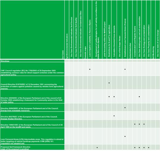
24 Soil & EU regulations
25 INSPIRE Soil data model One soil data model defines following major spatial object types: Soil profile (both observed and derived) Profile element (including soil layer and soil horizon) Soil Body Soil Derived Object (including both representation types) Soil Site Soil Plot Extensions (in the TG Annex C,D): Draft model for managing information related to contaminated sites as a possible extension to the INSPIRE data model Soil (not to be part of legislation) Provision of soil thematic map elaborated Use case how to provide soil organic carbon content by using the INSPIRE Soil data model
26 Monitoring Soil data vectors class Soil: Overview SoilSite + geometry :GM_Object + inspireid :Identifier [0..1] + soilinvestigationpurpose :SoilInvestigationPurposeValue «lifecycleinfo, voidable» + beginlifespanversion :DateTime + endlifespanversion :DateTime [0..1] «voidable» + validfrom :DateTime + validto :DateTime [0..1] +locatedon 0..1 «voidable» SoilProfile + inspireid :Identifier [0..1] «lifecycleinfo, voidable» + beginlifespanversion :DateTime + endlifespanversion :DateTime [0..1] «voidable» + localidentifier :CharacterString [0..1] + othersoilname :OtherSoilNameType [0..*] + validfrom :DateTime + validto :DateTime [0..1] + WRBSoilName :WRBSoilNameType Soil profile 1..* +isobservedonlocation «voidable» 1 +ispartof SoilPlot +observedprofile +isderivedfrom + inspireid :Identifier [0..1] +location «voidable» ObservedSoilProfile «voidable» «voidable» + soilplotlocation :Location + soilplottype :SoilPlotTypeValue * «lifecycleinfo, voidable» + beginlifespanversion :DateTime 0..* + endlifespanversion :DateTime [0..1] +isbasedonobservedsoilprofile «voidable» +isdescribedby «voidable» 1..* Soil derived information SoilDerivedObject + geometry :GM_Object + inspireid :Identifier [0..1] +isbasedonsoilderivedobject «voidable» 0..* ProfileElement + inspireid :Identifier [0..1] + profileelementdepthrange :RangeType «lifecycleinfo, voidable» + beginlifespanversion :DateTime + endlifespanversion :DateTime [0..1] «voidable» + particlesizefraction :ParticleSizeFractionType [1..*] DerivedSoilProfile +isdescribedby 1..* «voidable» DerivedProfilePresenceInSoilBody «voidable» + derivedprofilepercentagerange :RangeType SoilBody + geometry :GM_MultiSurface + inspireid :Identifier [0..1] «lifecycleinfo, voidable» + beginlifespanversion :DateTime + endlifespanversion :DateTime [0..1] «voidable» + soilbodylabel :CharacterString Soil map +isbasedonsoilbody «voidable» 0..* SoilHorizon «voidable» + FAOHorizonNotation :FAOHorizonNotationType + otherhorizonnotation :OtherHorizonNotationType [0..*] SoilLayer + layertype :LayerTypeValue «voidable» + layergenesisenvironment :EventEnvironmentTerm [0..1] + layergenesisprocess :EventProcessTerm [0..1] + layergenesisprocessstate :LayerGenesisProcessStateValue [0..1] + layerrocktype :LithologyTerm [0..*] {geogenicconstraint} constraints
27 Soil thematic maps coverage class Soil: Overview Coverages (Base)::Coverage + metadata :Any [0..*] + rangetype :RecordType Generic ISO Coverage classes Coverages (Domain and Range):: CoverageByDomainAndRange + coveragefunction :CoverageFunction [0..1] + domainset :Any + rangeset :Any [0..*] {ordered} constraints {gridfunctionrequiresgriddomain} Coverages (Domain and Range):: RectifiedGridCoverage constraints {domainisrectifiedgrid} Soil thematic map - coverage SoilThemeCov erage + domainextent :EX_Extent [1..*] + soilthemeparameter :SoilThemeParameterType «lifecycleinfo» + beginlifespanversion :DateTime + endlifespanversion :DateTime [0..1] «voidable» + validtimefrom :Date + validtimeto :Date [0..1] constraints {rangesetvaluesconstraint} +isdescribing 0..* {equaldomain} 1 +isdescribedby «voidable» SoilThemeDescriptiv ecov erage + domainextent :EX_Extent [1..*] + soilthemedescriptiveparameter :SoilThemeDescriptiveParameterType «lifecycleinfo» + beginlifespanversion :DateTime + endlifespanversion :DateTime [0..1]
28 Semantic interoperability WRB (World reference base for soil resources 2006, first update 2007 ) is used as standard soil type classification system; however it is made possible to use national classification systems (additional) FAO (Guidelines for soil description, 4th edition, Food and Agriculture Organization of the United Nations, Rome, 2006, pp ) is used for Soil horizon classification Re-using of classification schemas from geology related to the Soil layer rock and genesis descriptions
29 Soil parameters in the model Important parameters in the model due to adopted EU Regulations: Soil profile: WRB name (or national soil type), potential root depth, available water capacity, carbon stock, water drainage Profile element: particle size fraction, organic carbon content, N, ph, Cd, Cr, Cu, Pb, Hg, Ni Soil derived object: potential root depth, available water capacity, carbon stock, water drainage, particle size fraction, organic carbon content, N, ph, Cd, Cr, Cu, Pb, Hg, Ni, Zn Soil site: any chemical, biological, physical properties The integration specialisation of the generic O&M ISO standard to provide soil measurement information
30 Development of the INSPIRE Soil data specification covers: 11 TWG-SO members 3 years teleconferences 7 Face to face meetings 3 cross-theme workshops 3 major versions of the document 190 pages in version pages in version pages in version Use cases 240 received comments on version recieved comments on the 1 st Draft of the IR 3 INSPIRE conferences

31 The people behind TWG INSPIRE Soil: Arnold Arnoldussen (TWG Facilitator), Stijn Keijers (TWG Editor), Jandirk Bulens (TWG co-editor), Christine Le Bas, Edoardo Costantini, Einar Eberhardt, Marc van Liedekerke, Stephan Marahrens, Ainara Senar, Kees Versluijs, Robert Tomas (JRC contact point).

")

32 The faces behind..(2010) The faces behind..(2012)
33 In Summary INSPIRE is now! MSs are implementing Inspire compliant services. The 2012, 2015, 2017 and 2020 deadlines for Annex I, II & III mean that work to comply with INSPIRE needs to be starting now. INSPIRE is an opportunity - widens the use of data held by thematic environmental communities. INSPIRE is a multi-purpose infrastructure Activities on-going to re-use INSPIRE in other policy areas (Digital Agenda for Europe, WFD ) INSPIRE facilitates the use of international standards (ISO, CEN, OGC, WRB, FAO) as well as taking active part in their development e.g. OGC GWML 2.0 Interoperability experiment


34 Coordination Transparency and inclusiveness Stakeholder consultations Support to Member States on the implementation Extend INSPIRE to and ensure consistency of different policy domains Promote INSPIRE in international standardisation

35 More information: INSPIRE INSPIRE data specifications Overview Data models atamodels Schemas
European Directive (2007/2/EC) INSPIRE sharing data in an interoperable way
 INSPIRE sharing data in an interoperable way") European Directive (2007/2/EC) INSPIRE sharing data in an interoperable way Robert Tomas 7 th European Conference on Regional Geoscientific Cartography and Information Systems Bologna, 12 th -15 th June
European Directive (2007/2/EC) INSPIRE sharing data in an interoperable way Robert Tomas 7 th European Conference on Regional Geoscientific Cartography and Information Systems Bologna, 12 th -15 th June
INSPIRE Basics. Vlado Cetl European Commission Joint Research Centre. https://ec.europa.eu/jrc/
 INSPIRE Basics Vlado Cetl European Commission Joint Research Centre https://ec.europa.eu/jrc/ Serving society Stimulating innovation Supporting legislation Outline SDI? Why European SDI? INSPIRE Policy
ESBN. Working Group on INSPIRE
 ESBN Working Group on INSPIRE by Marc Van Liedekerke, Endre Dobos and Paul Smits behalf of the WG members WG participants Marc Van Liedekerke Panos Panagos Borut Vrščaj Ivana Kovacikova Erik Obersteiner
INSPIRE Directive. Status June 2007
 INSPIRE Directive INfrastructure for SPatial InfoRmation in Europe Status June 2007 European Commission Directorate-General Environment Research, Science and Innovation Unit Rue de la Loi, 200 1049 Brussels
Infrastructure for Spatial Information in Europe (INSPIRE)
") Infrastructure for Spatial Information in Europe (INSPIRE) 2011 GISCO Working Party 8-9.3.2012 INSPIRE is about improving access to spatial information: the environment doesn t stop at borders EU Geoportal
Infrastructure for Spatial Information in Europe (INSPIRE) 2011 GISCO Working Party 8-9.3.2012 INSPIRE is about improving access to spatial information: the environment doesn t stop at borders EU Geoportal
INSPIREd solutions for Air Quality problems Alexander Kotsev
 INSPIREd solutions for Air Quality problems Alexander Kotsev www.jrc.ec.europa.eu Serving society Stimulating innovation Supporting legislation The European data puzzle The European data puzzle 24 official
INSPIRE General Introduction & Service Architecture
 INSPIRATION Spatial Data Infrastructure in the Western Balkans INSPIRE General Introduction & Service Architecture 1st National INSPIRATION Workshop Croatia November 21-22, 2012 A multi-countryprojectfunded
Progress of UN-GGIM: Europe Working Group A on Core Data
 INSPIRE KEN 13 December 2016 Progress of UN-GGIM: Europe Working Group A on Core Data François Chirié, Dominique Laurent, IGN France Plan Introduction Objectives of the working group with respect to INSPIRE
INSPIRE - A Legal framework for environmental and land administration data in Europe
 INSPIRE - A Legal framework for environmental and land administration data in Europe Dr. Markus Seifert Bavarian Administration for Surveying and Cadastre Head of the SDI Office Bavaria Delegate of Germany
Open Data meets Big Data
 Open Data meets Big Data Max Craglia, Sven Schade, Anders Friis European Commission Joint Research Centre www.jrc.ec.europa.eu Serving society Stimulating innovation Supporting legislation JRC is Technical
The contribution of EUREF to Inspire
 EUREF2010 SYMPOSIUM The contribution of EUREF to Inspire J. Torres, V. Bitenc, A. Caporali, P. Cruddace, L. Engberg, B. Garayt and H. Habrich (members of TWG-RS) June 2-4, 2010 Gävle 1 EUREF2010 SYMPOSIUM
Proposal for a DIRECTIVE OF THE EUROPEAN PARLIAMENT AND OF THE COUNCIL. establishing an infrastructure for spatial information in the Community
 Proposal for a DIRECTIVE OF THE EUROPEAN PARLIAMENT AND OF THE COUNCIL establishing an infrastructure for spatial information in the Community INSPIRE http://inspire.jrc.it/ Alessandro Annoni 1 EU Commission
INSPIRATION results and benefits for the Agency for Real Estate Cadastre
 JOINT RESEARCH CENTER - E&I WORKSHOP INSPIRATION results and benefits for the Agency for Real Estate Cadastre Sonja Dimova, state advisor AGENCY FOR REAL ESTATE CADASTRE REPUBLIC OF MACEDONIA Wednesday,
INSPIRE Land Cover Data Specifications to model fuel maps in Europe: the experience of the ArcFUEL LIFE+ project
 INSPIRE Land Cover Data Specifications to model fuel maps in Europe: the experience of the ArcFUEL LIFE+ project Giacomo Martirano Epsilon Italia srl Mendicino (CS), IT g.martirano@epsilon-italia.it INSPIRE
Infrastructure for Spatial Information in Europe (INSPIRE) Steve Peedell
 Steve Peedell") Infrastructure for Spatial Information in Europe (INSPIRE) Steve Peedell European Commission DG Joint Research Centre Institute for Environment and Sustainability ESDI Action Overview JRC, European Commission
Infrastructure for Spatial Information in Europe (INSPIRE) Steve Peedell European Commission DG Joint Research Centre Institute for Environment and Sustainability ESDI Action Overview JRC, European Commission
Report on the establishment of UN GGIM: Europe Item 14. 4th session of the Committee of Experts on UN-GGIM
 Report on the establishment of UN GGIM: Europe Item 14 1 Why regional European committees of UN GGIM? In the ECOSOC resolution 2011/24 on the UN GGIM: Emphasizes the importance of promoting national, regional
ArcGIS for INSPIRE. Marten Hogeweg
 ArcGIS for INSPIRE Marten Hogeweg Please Take Our Survey on the App Download the Esri Events app and find your event Select the session you attended Scroll down to find the feedback section Complete answers
Progress of UN-GGIM: Europe Working Group A on Core Data
 PolicyKEN Budapest 29 November 2016 Progress of UN-GGIM: Europe Working Group A on Core Data François Chirié, Dominique Laurent, IGNF Core data context Background and purpose Aim of Work Group A to propose
a national geological survey perspective François ROBIDA BRGM (French Geological Survey)
") a national geological survey perspective François ROBIDA BRGM (French Geological Survey) Pre-Conference Seminar on Socio-Economic Value of Geospatial for National and Regional Development 21 August 2017,
a national geological survey perspective François ROBIDA BRGM (French Geological Survey) Pre-Conference Seminar on Socio-Economic Value of Geospatial for National and Regional Development 21 August 2017,
Update on INSPIRE; interoperable framework for natural hazards
 Update on INSPIRE; interoperable framework for natural hazards Robert Tomas EC-DG Joint Research Centre 16 th Meeting of Working Group F on Floods 2014, Rome www.jrc.ec.europa.eu Serving society Stimulating
EuroGeographics & INSPIRE. Nick Land, Executive Director of EuroGeographics
 EuroGeographics & INSPIRE Nick Land, Executive Director of EuroGeographics EuroGeographics A growing association 49 Members, 42 countries Topographic mapping, cadastre, land registry + Networked organisation
Benefits Realised from INSPIRE:
 Benefits Realised from INSPIRE: Max Craglia European Commission Joint Research Centre www.jrc.ec.europa.eu Serving society Stimulating innovation Supporting legislation Background to INSPIRE Europe is
Work Group A «Core Data» Report and Update François Chirié, Dominique Laurent, France
 JOINT UN-GGIM: EUROPE ESS MEETING ON THE INTEGRATION OF STATISTICAL AND GEOSPATIAL INFORMATION LUXEMBOURG 11 MARCH 2016 Work Group A «Core Data» Report and Update François Chirié, Dominique Laurent, France
INSPIRE. Data Specification for Meteorology. Bruce Wright, Expert Strategic Advisor (Data Management)
") INSPIRE Data Specification for Meteorology Bruce Wright, Expert Strategic Advisor (Data Management) Third Workshop on the use of GIS/OGC Standards in Meteorology- 15 November 2010 Table of Contents INSPIRE
INSPIRE Data Specification for Meteorology Bruce Wright, Expert Strategic Advisor (Data Management) Third Workshop on the use of GIS/OGC Standards in Meteorology- 15 November 2010 Table of Contents INSPIRE
Spatially enabling e-government through geo-services
 Spatially enabling e-government through geo-services Mauro Salvemini EUROGI PRESIDENT Professor at Sapienza Università di Roma (IT) 1 About the presentation Few information about Eurogi ; Some essential
INSPIRE Infrastructure for Spatial Information in Europe. Data Specification on Soil Draft Technical Guidelines
 Infrastructure for Spatial Information in Europe D2.8.III.3 Data Specification on Soil Draft Technical Guidelines Title Creator Date 2013-02-04 Subject Publisher Type Description Contributor Format Source
UN-GGIM: Europe ExCom 1 June 2016 Francfort Work Group A «Core Data» Status and Progress François Chirié, France
 UN-GGIM: Europe ExCom 1 June 2016 Francfort Work Group A «Core Data» Status and Progress François Chirié, France Plan The Core Data Scope Deliverable 7-8 June 2016 WGA workshop to investigate work plans
Roadmap to interoperability of geoinformation
 Roadmap to interoperability of geoinformation and services in Europe Paul Smits, Alessandro Annoni European Commission Joint Research Centre Institute for Environment and Sustainability paul.smits@jrc.it
INSPIRE Land Cover and Land Use Data Specifications
 INSPIRE Land Cover and Land Use Data Specifications Lena Hallin-Pihlatie Facilitator of the Land Cover and Land Use INSPIRE Thematic Cluster www.jrc.ec.europa.eu Serving society Stimulating innovation
Turkey s National SDI Implementation
 Onur PAŞAOĞULLARI Head of Department Turkey s National SDI Implementation Presentation Plan NSDI Background General Directorate of Geographic Information Systems NSDI Project INSPIRE Directive Urban Information
The Infrastructure for Spatial Information in the European Community vs. regional SDI: the shortest way for reaching economic and social development
 The Infrastructure for Spatial Information in the European Community vs. regional SDI: the shortest way for reaching economic and social development Mauro Salvemini EUROGI PRESIDENT Professor at Sapienza
The Global Fundamental Geospatial Data Themes Journey. April Clare Hadley WG Chair
 The Global Fundamental Geospatial Data Themes Journey April 2018 Clare Hadley WG Chair The Road to here Why Global? Why Geospatial? Why Fundamental? Why Themes? The route we took Where does the road go
UNOFFICIAL TRANSLATION
 UNOFFICIAL TRANSLATION THE CROATIAN PARLIAMENT 1135 Pursuant to Article 89 of the Constitution of the Republic of Croatia, I hereby issue the DECISION PROMULGATING THE NATIONAL SPATIAL DATA INFRASTRUCTURE
SDI and VGI Parallel Universes? Max Craglia Institute for Environment and Sustainability Spatial Data Infrastructures Unit
 1 SDI and VGI Parallel Universes? Max Craglia Institute for Environment and Sustainability Spatial Data Infrastructures Unit 2 Background There is a growing awareness that we are living at a time when
INSPIRE Monitoring and Reporting Implementing Rule Draft v2.1
 INSPIRE Infrastructure for Spatial Information in Europe INSPIRE Monitoring and Reporting Implementing Rule Draft v2.1 Title INSPIRE Monitoring and Reporting Implementing Rule v2.1 Creator DT Monitoring
INSPIRE Annex II+III themes. Data specification testing. Theme: SOIL
 INSPIRE Annex II+III themes. Data specification testing Theme: SOIL Edited by: Paola Tarocco Marica Landini OCTOBER 2011 SOIL CORE MODEL TESTING The proposed INSPIRE Soil Core Model has been tested using
The state-of-the-art of the Finnish SDI. Arctic SDI WG Meeting
 The state-of-the-art of the Finnish SDI Arctic SDI WG Meeting Moscow 8.9.2011 Esa Tiainen Development Centre 1 NATIONAL LAND SURVEY DOWN TO EARTH Contents Legal framework Coordination structure Network
Tomas Mildorf, Karel Janecka University of West Bohemia in Pilsen Czech Republic
 European Network of Best Practices for Interoperability of Spatial Planning Information Tomas Mildorf, Karel Janecka mildorf@centrum.cz, kjanecka@kma.zcu.cz University of West Bohemia in Pilsen Czech Republic
Harmonisation of Spatial Planning Data
 INSPIRE Conference 18 June 2011 Edinburgh, Great Britain Harmonisation of Spatial Planning Data Tomas Mildorf University of West Bohemia mildorf@centrum.cz Pilsen, Czech Republic Co-funded by the Community
SDI Development in Georgia. Mari Khardziani Head of International Relations Unit National Agency of Public Registry
 SDI Development in Georgia Mari Khardziani Head of International Relations Unit National Agency of Public Registry Kehl, Germany September 5, 2017 2 National Agency of Public Registry Legal Entity of Public
SITMUN: Cooperating to Build Local SDIs in the Barcelona Region
 SITMUN: Cooperating to Build Local SDIs in the Barcelona Region Diputació de Barcelona Territory and Sustainability Area Territorial Information Systems Department INSPIRE CONFERENCE Barcelona, September
Local Spatial Data Infrastructure, a Solid Base for Sustainable Land Management in Germany
 Local Spatial Data Infrastructure, a Solid Base for Sustainable Land Management in Germany FIG Commission 3 Workshop and Commission 3 Annual Meeting The Empowerment of Local Authorities: Spatial Information
The UN-GGIM: Europe core data initiative to encourage Geographic information supporting Sustainable Development Goals Dominique Laurent, France
 INSPIRE conference Strasbourg 6 September 2017 The UN-GGIM: Europe core data initiative to encourage Geographic information supporting Sustainable Development Goals Dominique Laurent, France Introduction
Implementing strategy for the Infrastructure for Spatial Information in Europe - INSPIRE Paul Smits
 Implementing strategy for the Infrastructure for Spatial Information in Europe - INSPIRE Paul Smits European Commission DG Joint Research Centre Institute for Environment and Sustainability Ispra, Italy
State of the Art. in Spatial Planning Data Harmonisation & Spatial Data Infrastructure (SDI) Julia Neuschmid, CEIT ALANOVA
 Julia Neuschmid, CEIT ALANOVA") INSPIRE Conference, June 2010, Krakow State of the Art in Spatial Planning Data Harmonisation & Spatial Data Infrastructure (SDI) Julia Neuschmid, CEIT ALANOVA Co-funded by the Community programme econtentplus
INSPIRE Conference, June 2010, Krakow State of the Art in Spatial Planning Data Harmonisation & Spatial Data Infrastructure (SDI) Julia Neuschmid, CEIT ALANOVA Co-funded by the Community programme econtentplus
Inspiren toimeenpanon tilanne Euroopassa
 Inspiren toimeenpanon tilanne Euroopassa INSPIRE liitteiden II ja III mukaiset uudet tietotuotemäärittelyt ja niiden lausuntomenettely -koulutustilaisuus 22.8.2011 Antti Vertanen, MMM INSPIRE adoption
Providing Marine Data. The German Marine Data Infrastructure (MDI-DE) as an example for best practice
 as an example for best practice") Providing Marine Data The German Marine Data Infrastructure (MDI-DE) as an example for best practice Data Originators 18 Agencies and Institutions in the EEZ and 12 Mile Zone Federal Government BSH Schleswig-Holstein
Providing Marine Data The German Marine Data Infrastructure (MDI-DE) as an example for best practice Data Originators 18 Agencies and Institutions in the EEZ and 12 Mile Zone Federal Government BSH Schleswig-Holstein
Interoperability of Spatial Planning Data
 INSPIRE Conference 2010, Krakow, Poland Interoperability of Spatial Planning Data European Network of Best Practices for Interoperability of Spatial Planning Information Tomas Mildorf mildorf@centrum.cz
EUREF2009 SYMPOSIUM. J. Torres, V. Bitenc, A. Caporali, P. Cruddace, L. Engberg, B. Garayt and H. Habrich
 EUREF2009 SYMPOSIUM The European Reference Systems in Inspire J. Torres, V. Bitenc, A. Caporali, P. Cruddace, L. Engberg, B. Garayt and H. Habrich (members of TWG-RS) May 27-29, 2009 Florence 1 SUMMARY
Status of implementation of the INSPIRE Directive 2016 Country Fiches. COUNTRY FICHE Ireland
 Status of implementation of the INSPIRE Directive 2016 Country Fiches COUNTRY FICHE Ireland Introduction... 1 1. State of Play... 2 1.1 Coordination... 2 1.2 Functioning and coordination of the infrastructure...
GIS Building Communities beyond National Borders (Building Successful Spatial Data Infrastructures) Nick Land, ESRI Europe
 Nick Land, ESRI Europe") GIS Building Communities beyond National Borders (Building Successful Spatial Data Infrastructures) Nick Land, ESRI Europe UK worst flooding in the last 60 years 350,000 households without drinking water
GIS Building Communities beyond National Borders (Building Successful Spatial Data Infrastructures) Nick Land, ESRI Europe UK worst flooding in the last 60 years 350,000 households without drinking water
Plan4all (econtentplus project)
") Plan4all (econtentplus project) Karel CHARVAT 1, Tomáš MILDORF 2 1 Help service remote sensing, Ltd., Černoleská 1600, 256 01 Benešov u Prahy, Czech Republic charvat@bnhelp.cz 2 Department of Mathematics
Plan4all (econtentplus project) Karel CHARVAT 1, Tomáš MILDORF 2 1 Help service remote sensing, Ltd., Černoleská 1600, 256 01 Benešov u Prahy, Czech Republic charvat@bnhelp.cz 2 Department of Mathematics
ArcGIS for INSPIRE. Marten Hogeweg Satish Sankaran
 ArcGIS for INSPIRE Marten Hogeweg Satish Sankaran Outline What is ArcGIS ArcGIS for INSPIRE Web GIS Case Studies Roadmap Q&A What is INSPIRE? INSPIRE is the legal framework for a European Spatial Data
Data Origin. Ron van Lammeren CGI-GIRS 0910
 Data Origin Ron van Lammeren CGI-GIRS 0910 How to obtain geodata? Geo data initiative Executive Order 12906, "Coordinating Geographic Data Acquisition and Access: The National Spatial Data Infrastructure,"
Implementation of Inspire in Denmark - How we get it flying! Olav Eggers National Survey & Cadastre -Denmark
 Implementation of Inspire in Denmark - How we get it flying! Olav Eggers oe@kms.dk National Survey & Cadastre -Denmark Introduction Overview Infrastructure for Spatial Information Act National Survey and
Data Origin. How to obtain geodata? Ron van Lammeren CGI-GIRS 0910
 Data Origin How to obtain geodata? Ron van Lammeren CGI-GIRS 0910 Spatial Data interest Improvement of policy making. ± 90% of all information used by government has spatial characteristics SPATIAL INFORMATION
Status of implementation of the INSPIRE Directive 2016 Country Fiches. COUNTRY FICHE Malta
 Status of implementation of the INSPIRE Directive 2016 Country Fiches COUNTRY FICHE Malta Introduction... 1 1. State of Play... 2 1.1 Coordination... 2 1.2 Functioning and coordination of the infrastructure...
Status of implementation of the INSPIRE Directive 2016 Country Fiches. COUNTRY FICHE Croatia
 Status of implementation of the INSPIRE Directive 2016 Country Fiches COUNTRY FICHE Croatia Introduction... 1 1. State of Play... 2 1.1 Coordination... 2 1.2 Functioning and coordination of the infrastructure...
Status of implementation of the INSPIRE Directive 2016 Country Fiches. COUNTRY FICHE France
 Status of implementation of the INSPIRE Directive 2016 Country Fiches COUNTRY FICHE France Introduction... 1 1. State of Play... 2 1.1 Coordination... 2 1.2 Functioning and coordination of the infrastructure...
Status of implementation of the INSPIRE Directive 2016 Country Fiches. COUNTRY FICHE Netherlands
 Status of implementation of the INSPIRE Directive 2016 Country Fiches COUNTRY FICHE Netherlands Introduction... 1 1. State of Play... 2 1.1 Coordination... 2 1.2 Functioning and coordination of the infrastructure...
SDI in Finland Nordic SDI Seminar Uppsala Panu Muhli
 SDI in Finland Nordic SDI Seminar Uppsala 3.10.2011 Panu Muhli Spatial Data Infrastructure Team Inspire secretariat Development Centre 1 NATIONAL LAND SURVEY DOWN TO EARTH Contents Legal framework Coordination
Status of implementation of the INSPIRE Directive 2016 Country Fiches. COUNTRY FICHE Czech Republic
 Status of implementation of the INSPIRE Directive 2016 Country Fiches COUNTRY FICHE Czech Republic Introduction... 1 1. State of Play... 2 1.1 Coordination... 2 1.2 Functioning and coordination of the
Data Specification Elevation v2.0
 INSPIRE DS Stream Data Specification Elevation v2.0 Jordi Escriu Paradell - TWG EL Editor Institut Cartogràfic de Catalunya (ICC) INSPIRE Conference 2011 Edinburgh, 29 th June -1 st July 2011 1 This presentation
Recommendations for INSPIRE Spatial Data Services
 INSPIRE Infrastructure for Spatial Information in Europe Recommendations for INSPIRE Spatial Data Services Title Creator Recommendations for INSPIRE Spatial Data Services Spatial Data Services Working
Recommendations for INSPIRE Spatial Data Services
 INSPIRE Infrastructure for Spatial Information in Europe Recommendations for INSPIRE Spatial Data Services Title Creator Recommendations for INSPIRE Spatial Data Services Spatial Data Services Working
ArcGIS for INSPIRE. Paul Hardy. ArcGIS. ArcGIS for INSPIRE Enables Esri ArcGIS users to implement and comply with INSPIRE. INSPIRE Data Themes
 Enables Esri ArcGIS users to implement and comply with INSPIRE Paul Hardy phardy@esri.com EuroGeographics INSPIRE KEN (Schema Transformation) 8/9 October 2013, Marne la Vallée INSPIRE Data Themes Annex
SWEDISH SDI DEVELOPMENT & IMPLEMENTATION OF INSPIRE
 SWEDISH SDI DEVELOPMENT & IMPLEMENTATION OF INSPIRE Christina Wasström, Lantmäteriet, 801 82 Gävle, Sweden, christina.wasstrom@lm.se ABSTRACT The Swedish Government and Parliament has given Lantmäteriet
Status of implementation of the INSPIRE Directive 2016 Country Fiches. COUNTRY FICHE Italy
 Status of implementation of the INSPIRE Directive 2016 Country Fiches COUNTRY FICHE Italy Introduction... 1 1. State of Play... 2 1.1 Coordination... 2 1.2 Functioning and coordination of the infrastructure...
Emerging Trends in Institutional Arrangements Europe - Finland
 Emerging Trends in Institutional Arrangements Europe - Finland Arvo Kokkonen Deputy Director General National Land Survey of Finland 1 Contents Facts about Finland National Land Survey of Finland European
Geological information for Europe : Towards a pan-european Geological Data Infrastructure
 Geological information for Europe : Towards a pan-european Geological Data Infrastructure Integrating geoscientific information for EU competitiveness Co-funded by the European Union European societal
Standards in support of UN-GGIM and sustainable development
 2 nd High 2Level nd High Forum Level on GGIM, Forum QNCC, on GGIM Doha, Qatar, 6 February 2013 QNCC, Doha, Qatar, 6 February 2013 Standards in support of UN-GGIM and sustainable development Olaf Østensen
AN OVERVIEW OF SPATIAL DATA INFRASTRUCTURE OF TURKEY WITH A VIEW TO COMPLYING WITH INSPIRE STANDARDS
 AN OVERVIEW OF SPATIAL DATA INFRASTRUCTURE OF TURKEY WITH A VIEW TO COMPLYING WITH INSPIRE STANDARDS Ebru Alarslan Halil Söğüt OUTLINE A Brief History of SDI in Turkey Milestones in the History of SDI
What does EUREF considers as a realisation of EVRS?
 1 (1) DRAFT PM 2010-05-24 previous versions: 2010-03-08 2010-02-15 What does EUREF considers as a realisation of EVRS? Contents Contents...1 Purpose of document...1 Short review on activities towards a
Workshop on Global Fundamental Geospatial Data Themes
 Workshop on Global Fundamental Geospatial Data Themes June 2018 Objectives of the Workshop Introduce you to the work and outputs of the Fundamental Data WG (FDWG) Consider how the themes apply to SDGs
Establishing the National Spatial Data Infrastructure (NSDI) for Norway a joint effort by many stakeholders SPATIAL DATA FOR BENEFIT OF THE SOCIETY
 for Norway a joint effort by many stakeholders SPATIAL DATA FOR BENEFIT OF THE SOCIETY") Establishing the National Spatial Data Infrastructure (NSDI) for Norway a joint effort by many stakeholders SPATIAL DATA FOR THE BENEFIT OF SOCIETY OUTLINE Political background Norway digital - The Norwegian
Establishing the National Spatial Data Infrastructure (NSDI) for Norway a joint effort by many stakeholders SPATIAL DATA FOR THE BENEFIT OF SOCIETY OUTLINE Political background Norway digital - The Norwegian
D2.8.III.19 Data Specification on Species Distribution Draft Guidelines
 Infrastructure for Spatial Information in Europe D2.8.III.19 Data Specification on Species Distribution Draft Guidelines Title D2.8.III.19 INSPIRE Data Specification on Species Distribution Draft Guidelines
The road to national Inspire-compliant datasets in the Czech republic
 The road to national Inspire-compliant datasets in the Czech republic Ing. Pavel Šidlichovský (Land Survey Office of Czech Republic) INSPIRE 2014; 18.6. Aalborg Overview Directive transposition COSMC and
Economic and Social Council
 United Nations Economic and Social Council Distr.: General 2 July 2012 E/C.20/2012/10/Add.1 Original: English Committee of Experts on Global Geospatial Information Management Second session New York, 13-15
Ministry of ICT of I.R.IRAN
 The ECO 8/6 mill km 2 10 Slamic countries ~330 mill people Oil, Gas, Industries,Tourism 2 Issue transformation in last decade Problem solving needs more integrated approach More interaction &complexity
Estonian approach to implementation of INSPIRE directive. Sulev Õitspuu Head of Bureau of Geoinfosystems Estonian Land Board
 Estonian approach to implementation of INSPIRE directive Sulev Õitspuu Head of Bureau of Geoinfosystems Estonian Land Board 13.06.2016 Contents - INSPIRE coordination in Estonia - INSPIRE implementation
Application Domain Extensions definition for crowd source and Volunteer Geographic Information for smart-cities services deployment.
 Application Domain Extensions definition for crowd source and Volunteer Geographic Information for smart-cities services deployment. F. Prandi, R. de Amicis, P. Parslow, M. Ford, E. D Hondt Outlook Introduction
HydroSpatial II Practical application of INSPIRE in Marine Mapping Data
 HydroSpatial II Practical application of INSPIRE in Marine Mapping Data INSPIRE Conference 30 th June 2011 Carlos Berná Esteban, GIS Analyst, SeaZone carlos.berna-esteban@seazone.com Overview HydroSpatial
INSPIRE Implementation in Estonia using ArcGIS
 INSPIRE Implementation in Estonia using ArcGIS Sulev Õitspuu Head of Bureau of Geoinfosystems Estonian Land Board 26.09.2016 Population: 1,3 million (69% Estonians) Area: 45,339 km 2 15 counties Estonia
Compact guides GISCO. Geographic information system of the Commission
 Compact guides GISCO Geographic information system of the Commission What is GISCO? GISCO, the Geographic Information System of the COmmission, is a permanent service of Eurostat that fulfils the requirements
IHO STAKEHOLDERS FORUM. Hydrographic data and its role in MSDI. Thursday 27 September Jens Peter Hartmann KMS
 IHO STAKEHOLDERS FORUM Hydrographic data and its role in MSDI Thursday 27 September Jens Peter Hartmann KMS Agenda Traditional approach to hydrographic data Expectations within the marine / maritime field
Pushing implementation of European coverage data and services forward
 Pushing implementation of European coverage data and services forward Jordi Escriu jordi.escriu@icgc.cat Head of Unit / IDEC - SDI of Catalonia Facilitator INSPIRE Thematic Cluster #3 Elevation, Orthoimagery,
ESDIN Results from a Crossborder INSPIRE Preparatory Project. Jörgen Hartnor, Lantmäteriet.
 ESDIN Results from a Crossborder INSPIRE Preparatory Project Jörgen Hartnor, Lantmäteriet www.esdin.eu Ett econtentplus Best Practice Network projekt September 2008 February 2011 Coordinated by EuroGeographics
Coastal/Marine Thematic SDIs
 Coastal/Marine Thematic SDIs Roger Longhorn Principal Consultant (SDI), Compass Informatics Ltd Information Policy Advisor, Coastal & Marine Union (EUCC) Information Expert, Intergovernmental Oceanographic
The Process of Spatial Data Harmonization in Italy. Geom. Paola Ronzino
 The Process of Spatial Data Harmonization in Italy Geom. Paola Ronzino ISSUES Geospatial Information in Europe: lack of data harmonization the lack of data duplication of data CHALLENGES Challenge of INSPIRE:
MARINE SPATIAL PLANNING & MARINE CADASTRE: CHALLENGES AND ISSUES
 MARINE SPATIAL PLANNING & MARINE CADASTRE: CHALLENGES AND ISSUES Roger Longhorn Secretary General, GSDI Association rlonghorn@gsdi.org Member, IHO Marine SDI Working Group ral@alum.mit.edu Member, UNESCO
Data Specification Elevation v3.0
 INSPIRE DS Highlights Data Specification Elevation v3.0 Jordi Escriu - TWG EL Editor Institut Cartogràfic de Catalunya (ICC) INSPIRE Conference 2012 Istanbul, 25 th - 27 th June 2012 1 This presentation
Model Generalisation in the Context of National Infrastructure for Spatial Information
 Model Generalisation in the Context of National Infrastructure for Spatial Information Tomas MILDORF and Vaclav CADA, Czech Republic Key words: NSDI, INSPIRE, model generalization, cadastre, spatial planning
Status of implementation of the INSPIRE Directive 2016 Country Fiches. COUNTRY FICHE Portugal
 Status of implementation of the INSPIRE Directive 2016 Country Fiches COUNTRY FICHE Portugal Introduction... 1 1. State of Play... 2 1.1 Coordination... 2 1.2 Functioning and coordination of the infrastructure...
The Swedish National Geodata Strategy and the Geodata Project
 The Swedish National Geodata Strategy and the Geodata Project Ewa Rannestig, Head of NSDI Co-ordination Unit, Lantmäteriet, ewa.rannstig@lm.se Ulf Sandgren, Project Manager Geodata Project, Lantmäteriet,
Spatial Data Infrastructure Concepts and Components. Douglas Nebert U.S. Federal Geographic Data Committee Secretariat
 Spatial Data Infrastructure Concepts and Components Douglas Nebert U.S. Federal Geographic Data Committee Secretariat August 2009 What is a Spatial Data Infrastructure (SDI)? The SDI provides a basis for
INSPIRE Thematic Cluster on Land Cover and Land Use & Feedback from implementers
 INSPIRE Thematic Cluster on Land Cover and Land Use & Feedback from implementers Lena Hallin-Pihlatie Facilitator of the LC and LU Thematic Cluster www.jrc.ec.europa.eu Serving society Stimulating innovation
Werner Kuhn University of Muenster Geog 176C Class Slides Based on JRC Inspire Documents Thanks to Max Craglia et al.
 INSPIRE Directive of the European Parliament and the Council establishing an Infrastructure for Spatial Information in the European Community Werner Kuhn University of Muenster Geog 176C Class Slides Based
HELSINKI COMMISSION Baltic Marine Environment Protection Commission
 HELSINKI COMMISSION Baltic Marine Environment Protection Commission HELCOM RECOMMENDATION 24/10 Adopted 25 June 2003, having regard to Article 20, Paragraph 1 b) of the 1992 Helsinki Convention IMPLEMENTATION
I&CLC2000 in support to new policy initiatives (INSPIRE, GMES,..)
") I&CLC2000 in support to new policy initiatives (INSPIRE, GMES,..) Manfred Grasserbauer, Director Joint Research Centre Institute for Environment and Sustainability 1 IMAGE 2000 European mosaic of satellite
I&CLC2000 in support to new policy initiatives (INSPIRE, GMES,..) Manfred Grasserbauer, Director Joint Research Centre Institute for Environment and Sustainability 1 IMAGE 2000 European mosaic of satellite
INSPIRE Directives assessment of multiple geospatial information for vegetable production
 TÜRK TARIM ve DOĞA BİLİMLERİ DERGİSİ TÜRK TARIM ve DOĞA TURKISH BİLİMLERİ JOURNAL DERGİSİ of AGRICULTURAL and NATURAL SCIENCES www.turkjans.com INSPIRE Directives assessment of multiple geospatial information