FOURTEEN YEARS OF SPATIAL DATA FROM PLANTS OF CONCERN: WHAT ARE WE LEARNING?
|
|
|
- Annabel Ryan
- 5 years ago
- Views:
Transcription


1 FOURTEEN YEARS OF SPATIAL DATA FROM PLANTS OF CONCERN: WHAT ARE WE LEARNING? Rachel Goad, Manager, Plants of Concern Shannon Still, Postdoctoral Researcher, Chicago Botanic Garden Jeremie Fant, Conservation Scientist, Chicago Botanic Garden Anna Braum, Research Assistant, Plants of Concern


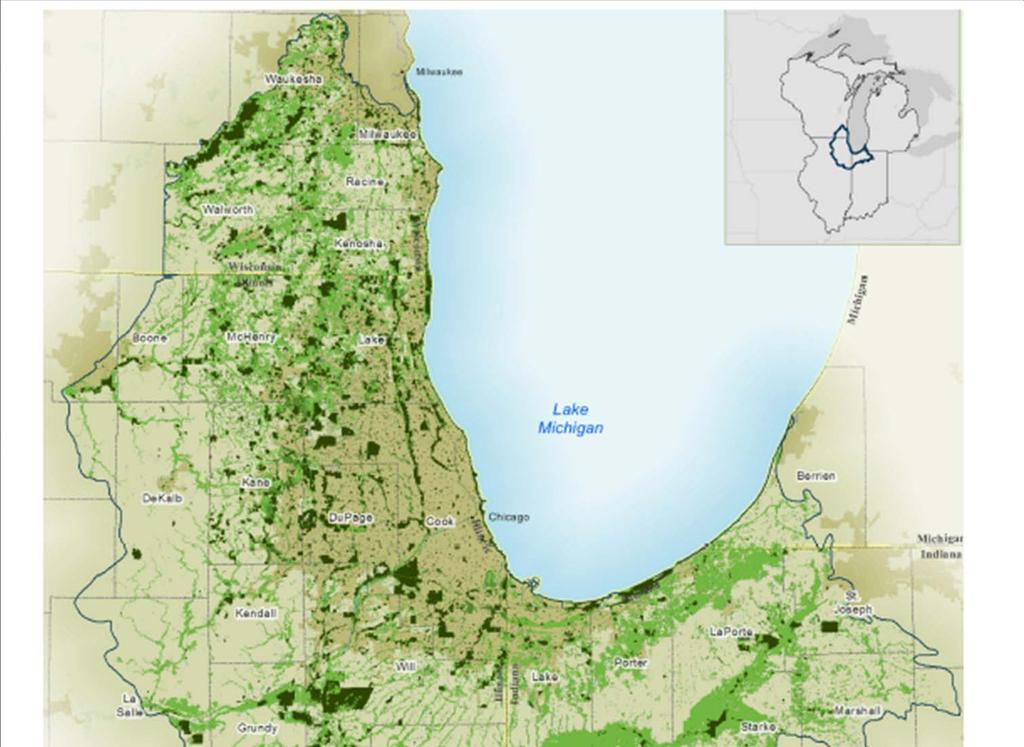
2 Plants of Concern Natural areas Tri state Chicago region Addressing Chicago Wilderness Biodiversity Recovery Plan


3 Plants of Concern Trained citizen scientists Standardized data Rare plant populations Partnerships Volunteer groups Federal, state, municipal Private landowners Researchers


4 POC s spatial data Intensive data management Additional training for volunteers Basics of spatial data Datum, Coordinate System Tested phone applications, units


5 GPS Training Attendees felt: 76% more knowledgeable about GPS 88% more comfortable with GPS for POC

6 POC s spatial data Adding data filters Visual check of population location Encoded check of population location Web mapping module in the works


7
8 Scope 288 species 1170 populations 15 counties 14 year dataset Answer questions Provide baseline for future studies


9 Scope Populations cover ~2 contiguous mi2 Ranging across 5900 mi2 Many distributed small populations
10 Questions Where do rare species occur? What can we learn about their niche? Where else might they occur? What else can we learn from POC data?


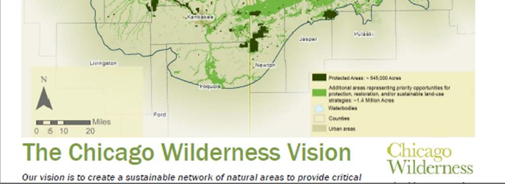
11 Land cover Chicago Wilderness Green Infrastructure Vision
12 Land Cover of POC populations Agriculture (7.4%) Floodplain Forest (3.5%) Native woody (2.4%) Prairie (17.3%) Savanna (14.2%) Unassoc. Grassy (10.4%) Unassoc. Woody (3.6%) Undefined (6.8%) Upland Forest (5.3%) Urban Grass (0.3%) Urban Land (6.0%) Water (3.7%) Wetland (19.0%)
13 Land Cover of POC populations Agriculture (7.4%) Floodplain Forest (3.5%) Native woody (2.4%) Prairie (17.3%) Savanna (14.2%) Unassoc. Grassy (10.4%) Unassoc. Woody (3.6%) Undefined (6.8%) Upland Forest (5.3%) Urban Grass (0.3%) Urban Land (6.0%) Water (3.7%) Wetland (19.0%)


14 What can we learn about species from where they grow? Identification of a niche Soil preferences Available water capacity Organic matter ph Silt, sand, clay % Comparisons between species net.com

15 Gravel hills Glacial outwash deposits islands of gravel Well drained, calcareous Often with associated fens Have become more isolated with mining pressure Support POC monitored species


16 Species comparison Gravel hill species dry Hill s Thistle (Cirsium hillii) Wooly Milkweed (Asclepias lanuginosa) Fen species wet White Lady s Slipper (Cypripedium candidum) Hill s Thistle Emily Kapler Wooly Milkweed Carol Freeman Lady s Slipper Carol Freeman


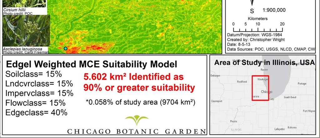
17 POC locationsavailable Water Capacity Cation Exchange Capacity
18 Niche identification: gravel hill species
19 NMDS Ordination Reduce many variables to two axes Visualize similarity/ difference between sites
20 Gravel hill species (Asclepias lanuginosa, Cirsium hillii) Milkweed is nested in Thistle Same habitat Species are statistically distinct Driven by silt and sand
21 White Lady s Slipper (Cypripedium candidum) Cluster near CEC, Organic Matter Ideal habitat The species has not done well at this sandy site
22 Population trends in relation to ordination Trend Thistle (Cirsium) NMDS 1 Lady s slipper (Cypripedium)

23 Habitat Suitability Modeling Can we identify suitable habitat across the region, using POC data? Use what we know about a plants niche Find existing plants and habitat Identify potential reintroduction locations


24 Gravel Hill Habitat Suitability Modeling Identify suitable habitat for Cirsium hillii Asclepias lanuginosa
25 Habitat Suitability Multi Criteria Evaluation Model Extract data: soil attributes land cover hydrology flow impervious surfaces distance to edge Classify gravel hill prairie habitat Model using 6 weighting structures
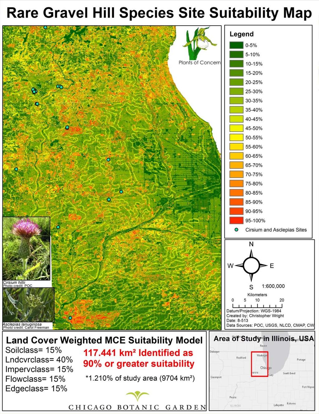
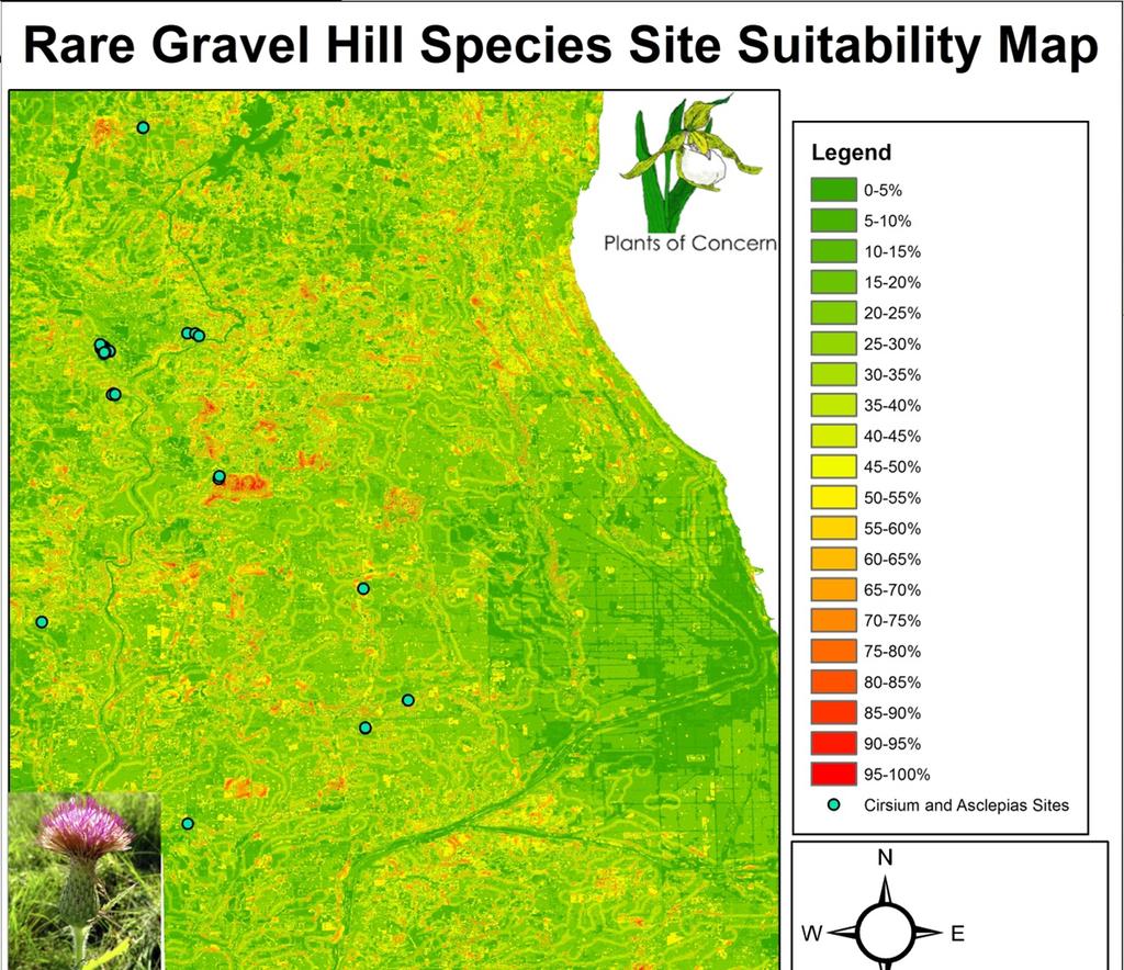
26

27 Habitat Suitability Refinement of criteria Remove flow, impervious surfaces, edge distances Ground truthing Attempts with other species


28 Savanna Blazing Star Liatris scariosa var. niewlandii Restricted to newer glacial moraines Associated with oak savannas Listed IL Threatened in 1987 Few languishing populations Daniel Suarez Bowles, Wilhelm, Packard (1988)

29 Savanna Blazing Star Liatris scariosa var. niewlandii Restoration and management have improved habitat POC monitors: 26 subpopulations 10 sites Populations clustered Why? Carol Freeman


30 Why are populations concentrated in S.W. Cook County? Land use of morainal till Red = high level of development

31 Management data Management information could improve understanding of population trends Need complete data

32 Restoration Maps as a tool Could improve spatial analysis of land management at the species level Data not available across multiple sites Limits functionality
33 What else can we learn about the region from POC spatial data?

34 Invasive species Invasive species are noted on every POC monitoring form GPS for monitored population give spatial reference

35 Invasive GPS Data

36 Invasive GPS data


37 Lake Michigan Early Detection Strike Team Using POC spatial data on invasive species Target invasives for removal Improve coastal habitat Partnership led by Lake Co. FPD
38 What s next? Improve suitability modeling Management information and analysis Partner with researchers!


39 Acknowledgements POC Volunteers! Dan Larkin Emily Yates Sarah Whidden Wade Van Nortwick Bianca Rosenbaum Chicago Wilderness & CMAP Susanne Masi Field Team 2014
Jim Turenne. Soils on Social Media
 Jim Turenne USDA-NRCS 60 Quaker Lane, Suite 46 Warwick, RI. 02886 401-822-8832 Jim.turenne@ri.usda.gov Soils on Social Media www.twitter.com/soilsne www.fb.com/soilsne www.nesoil.com U.S. Department of
Soils in Minnesota Calcareous Fens
 Soils in Minnesota Calcareous Fens MGWA TECHNICAL WORKSHOP June 18, 2004 George Poch 6/23/2004 1 Introduction Our presentation today is to show What soils are in the Fen areas How they have been mapped
Maggie Payne Jim Turenne
 Maggie Payne Jim Turenne USDA-NRCS 60 Quaker Lane, Suite 46 Warwick, RI. 02886 401-822-8832 maggie.payne@ri.usda.gov U.S. Department of Agriculture 1935: Soil Conservation Service (SCS) Natural Resources
Southwest LRT Habitat Analysis. May 2016 Southwest LRT Project Technical Report
 Southwest LRT Habitat Analysis Southwest LRT Project Technical Report This page intentionally blank. Executive Summary This technical report describes the habitat analysis that was performed to support
The future of the Lowland Belizean Savannas?.
 The future of the Lowland Belizean Savannas?. Using cluster analysis to explore multivariate spatial patterns in savanna soils PETER FURLEY & SARAH BEADLE UK Belize association 15 th November 2014 Outline
Kootenai River Habitat Restoration Program Update
 Kootenai River Habitat Restoration Program Update Kootenai Tribe of Idaho Kootenai Valley Resource Initiative November 19, 2012 Bonners Ferry, Idaho Changes to Kootenai Basin Beaver trapping Floodplain
Ecoregional Assessment of Biodiversity Conservation Executive Summary September 2006 Hawaiian High Islands
 Ecoregional Assessment of Biodiversity Conservation Executive Summary September 2006 Hawaiian High Islands This executive summary presents an 9-page overview of the Hawaiian High Islands Ecoregional Assessment
Native species (Forbes and Graminoids) Less than 5% woody plant species. Inclusions of vernal pools. High plant diversity
 Less than 5% woody plant species. Inclusions of vernal pools. High plant diversity") WILLAMETTE VALLEY WET-PRAIRIE RESTORATION MODEL WHAT IS A WILLAMETTE VALLEY WET-PRAIRIE Hot Spot s Native species (Forbes and Graminoids) Rare plant species Less than 5% woody plant species Often dominated
WILLAMETTE VALLEY WET-PRAIRIE RESTORATION MODEL WHAT IS A WILLAMETTE VALLEY WET-PRAIRIE Hot Spot s Native species (Forbes and Graminoids) Rare plant species Less than 5% woody plant species Often dominated
Opportunities to Improve Ecological Functions of Floodplains and Reduce Flood Risk along Major Rivers in the Puget Sound Basin
 Opportunities to Improve Ecological Functions of Floodplains and Reduce Flood Risk along Major Rivers in the Puget Sound Basin Christopher Konrad, US Geological Survey Tim Beechie, NOAA Fisheries Managing
MISSOURI LiDAR Stakeholders Meeting
 MISSOURI LiDAR Stakeholders Meeting East-West Gateway June 18, 2010 Tim Haithcoat Missouri GIO Enhanced Elevation Data What s different about it? Business requirements are changing.fast New data collection
The Midwest Invasive Species Information Network: Today and Tomorrow
 The Midwest Invasive Species Information Network: Today and Tomorrow Amos H. Ziegler Applied Spatial Ecology and Technical Services Laboratory Department of Entomology, Michigan State University RRIP IT
Soil Formation. Lesson Plan: NRES B2-4
 Soil Formation Lesson Plan: NRES B2-4 1 Anticipated Problems 1. What are five different factors that affect soil formation? 2. What are some different types of parent material that affect soils? 3. What
Geology and New England Landscapes
 Geology and New England Landscapes Jim Turenne, CPSS USDA-NRCS Warwick, RI. http://nesoil.com Why Geology? Provides the big picture of site conditions. Major part of soil formation (parent material and
Ecosystems Chapter 4. What is an Ecosystem? Section 4-1
 Ecosystems Chapter 4 What is an Ecosystem? Section 4-1 Ecosystems Key Idea: An ecosystem includes a community of organisms and their physical environment. A community is a group of various species that
A Comprehensive Inventory of the Number of Modified Stream Channels in the State of Minnesota. Data, Information and Knowledge Management.
 A Comprehensive Inventory of the Number of Modified Stream Channels in the State of Minnesota Data, Information and Knowledge Management Glenn Skuta Environmental Analysis and Outcomes Division Minnesota
Introduction to the Hydrogeomorphic (HGM) Classification System
 Classification System") Introduction to the Hydrogeomorphic (HGM) Classification System Objectives The Student Will be Able to: Define the 7 HGM Classes List the 3 Parameters That Define HGM Classes List the Major Water Budget
Introduction to the Hydrogeomorphic (HGM) Classification System Objectives The Student Will be Able to: Define the 7 HGM Classes List the 3 Parameters That Define HGM Classes List the Major Water Budget
Organism Interactions in Ecosystems
 Organism Interactions in Ecosystems Have you ever grown a plant or taken care of a pet? If so, you know they have certain needs such as water or warmth. Plants need sunlight to grow. Animals need food
Continue 59 Invasive. Yes. Place on invasive plant list, no further investigation needed. STOP. No. Continue on to question 2.
 Ohio Plant Assessment Protocol Posted Date: 7/2/ Step II Outcome: Directions: Place an "" in the Score column next to the selected answer to each of the four questions.. Is this plant known to occur in
EAGLES NEST AND PIASA ISLANDS
 EAGLES NEST AND PIASA ISLANDS HABITAT REHABILITATION AND ENHANCEMENT PROJECT MADISON AND JERSEY COUNTIES, ILLINOIS ENVIRONMENTAL MANAGEMENT PROGRAM ST. LOUIS DISTRICT FACT SHEET I. LOCATION The proposed
An Internet-based Agricultural Land Use Trends Visualization System (AgLuT)
") An Internet-based Agricultural Land Use Trends Visualization System (AgLuT) Second half yearly report 01-01-2001-06-30-2001 Prepared for Missouri Department of Natural Resources Missouri Department of
An Internet-based Agricultural Land Use Trends Visualization System (AgLuT) Second half yearly report 01-01-2001-06-30-2001 Prepared for Missouri Department of Natural Resources Missouri Department of
Wisconsin River Floodplain Project: Overview and Plot Metadata
 Wisconsin River Floodplain Project: Overview and Plot Metadata CLASS I. DATA SET DESCRIPTORS Data set identity: Plot-level variable information for Wisconsin River Floodplain Project. Relevant for following
ILLINOIS RIVER BASIN RESTORATION COMPREHENSIVE PLAN WITH INTEGRATED ENVIRONMENTAL ASSESSMENT APPENDIX B
 ILLINOIS RIVER BASIN RESTORATION COMPREHENSIVE PLAN WITH INTEGRATED ENVIRONMENTAL ASSESSMENT APPENDIX B SYSTEM ECOLOGY ILLINOIS RIVER BASIN RESTORATION COMPREHENSIVE PLAN WITH INTEGRATED ENVIRONMENTAL
McHenry County Property Search Sources of Information
 Disclaimer: The information in this system may contain inaccuracies or typographical errors. The information in this system is a digital representation of information derived from original documents; as
RANGE AND ANIMAL SCIENCES AND RESOURCES MANAGEMENT - Vol. II - Catchment Management A Framework for Managing Rangelands - Hugh Milner
 CATCHMENT MANAGEMENT A FRAMEWORK FOR MANAGING RANGELANDS Hugh Milner International Water Management Consultant, Australia Keywords: Rangeland management; catchments and watersheds; catchment management
Surface Water Short Study Guide
 Name: Class: Date: Surface Water Short Study Guide Multiple Choice Identify the letter of the choice that best completes the statement or answers the question. 1. The three ways in which a stream carries
BIODIVERSITY CONSERVATION HABITAT ANALYSIS
 BIODIVERSITY CONSERVATION HABITAT ANALYSIS A GIS Comparison of Greater Vancouver Regional Habitat Mapping with Township of Langley Local Habitat Mapping Preface This report was made possible through the
How Do Human Impacts and Geomorphological Responses Vary with Spatial Scale in the Streams and Rivers of the Illinois Basin?
 How Do Human Impacts and Geomorphological Responses Vary with Spatial Scale in the Streams and Rivers of the Illinois Basin? Bruce Rhoads Department of Geography University of Illinois at Urbana-Champaign
Soils of Rhode Island
 Soils of Rhode Island Jim Turenne, RI State Soil Scientist USDA-NRCS 60 Quaker Ln. Suite 46 Warwick, RI. 02886 401-822-8830 http://nesoil.com Jim.turenne@ri.usda.gov About NRCS Established as the Soil
Manitoulin Geology, People, and Plants
 Manitoulin Geology, People, and Plants Friends of Misery Bay, Manitoulin Island, August 14, 2011 Andy Fyon, Ontario Geological Survey, Sudbury, Ontario, Canada Not horticulturist or biologist. Not expert
Most people used to live like this
 Urbanization Most people used to live like this Increasingly people live like this. For the first time in history, there are now more urban residents than rural residents. Land Cover & Land Use Land cover
Watershed concepts for community environmental planning
 Purpose and Objectives Watershed concepts for community environmental planning Dale Bruns, Wilkes University USDA Rural GIS Consortium May 2007 Provide background on basic concepts in watershed, stream,
Partnering with LANDFIRE, NatureServe, and Heritage Programs. Utilizing Legacy Data for Ecological Site Concept Development and Descriptions
 Partnering with LANDFIRE, NatureServe, and Heritage Programs Utilizing Legacy Data for Ecological Site Concept Development and Descriptions Content LANDFIRE: BpS vs. EVT LANDFIRE: Disturbance Models NatureServe:
Transportation and Logistics Planning and Development Mapping Tool
 Transportation and Logistics Planning and Development Mapping Tool Doreen Gonzales-Gaboyan Business Development and Outreach Center for Innovation through Visualization and Simulation (CIVS) Purdue University
Pilot area description Aalborg south
 Pilot area description Aalborg south October 2014 Mette V. Odgaard, Department of Agroecology, Aarhus University Camilla Vestergaard, Knowledge Center for Agriculture P/S (eds.) 1 Content 1. General pilot
The 1979 Resource Inventory for Malmberg Prairie Polk County, Minnesota
 This document is made available electronically by the Minnesota Legislative Reference Library as part of an ongoing digital archiving project. http://www.leg.state.mn.us/lrl/lrl.asp The 1979 Resource Inventory
Using Grassland Vegetation Inventory Data
 Adam Moltzahn Eastern Short-Horned Lizard Using Grassland Vegetation Inventory Data The GVI represents the Government of Alberta s comprehensive biophysical, anthropogenic and land-use inventory of the
17 TH RRC ANNUAL NETWORK CONFERENCE. Planning, delivery and evaluation of our rivers: challenges and choices. Tweet us #RRCBlackpool
 17 TH RRC ANNUAL NETWORK CONFERENCE Tweet us #RRCBlackpool Planning, delivery and evaluation of our rivers: challenges and choices We would like to thank the sponsors of the conference who support discounted
Successful restoration of plant communities
 Successful restoration of plant communities WHY POLLINATORS MATTER Andrea T. Kramer Ph.D. Candidate, 2008 July 19, 2007 Today s presentation Area of study: the Great Basin Why restoration is needed What
McHenry County Property Search Sources of Information
 Disclaimer: The information in this system may contain inaccuracies or typographical errors. The information in this system is a digital representation of information derived from original documents; as
Lecture 29: Soil Formation
 Lecture 29: Soil Formation Factors Controlling Soil Formation 1. Parent material: Soil precursor 2. Climate: Temperature and precipitation 3. Biota: Native vegetation, microbes, soil animals, humans 4.
Unit E: Basic Principles of Soil Science. Lesson 2: Understanding Soil Formation
 Unit E: Basic Principles of Soil Science Lesson 2: Understanding Soil Formation Important Terms Alluvium Bedrock Chemical weathering Climate Glacial till Loess Native vegetation Organic matter Outwash
Vegetation and Terrestrial Wildlife
 Vegetation and Terrestrial Wildlife Vegetation Plant Communities Disturbance Unique Communities Wildlife Amphibians and Reptiles Birds Mammals Terrestrial Ecology: Vegetation Goals of vegetation sampling
Name Block Date. The Quadrat Study: An Introduction
 Name Block Date The Quadrat Study: An Introduction A quadrat study can almost be thought of as a snapshot of the ecosystem during a particular year and at a particular time of that year. The plant and
Phase 6 Land Use Database version 1
 Phase 6 Land Use Database version 1 Peter Claggett, Fred Irani, Quentin Stubbs, and Renee Thompson. June 11, 2015 Modeling Workgroup Meeting USGS MD-DE-DC Water Science Center U.S. Department of the Interior
THE MINISTRY OF ENERGY AND ENERGY INDUSTRIES MINERALS DIVISION MINE DESIGN TEMPLATE OPERATOR NAME: OPERATOR ADDRESS: PHONE NUMBER: FACSIMILE:
 THE MINISTRY OF ENERGY AND ENERGY INDUSTRIES MINERALS DIVISION MINE DESIGN TEMPLATE 1.0 GENERAL INFORMATION OPERATOR NAME: OPERATOR ADDRESS: PHONE NUMBER: FACSIMILE: NAME OF CONTACT: CELLULAR PHONE: EMAIL
Manitoba s Elevation (LiDAR) & Imagery Datasets. Acquisition Plans & Opportunities for Collaboration
 & Imagery Datasets. Acquisition Plans & Opportunities for Collaboration") Manitoba s Elevation (LiDAR) & Imagery Datasets Acquisition Plans & Opportunities for Collaboration Manitoba Planning Conference May 2017 Presentation Outline Manitoba s Elevation (LiDAR) and Imagery Datasets
Manitoba s Elevation (LiDAR) & Imagery Datasets Acquisition Plans & Opportunities for Collaboration Manitoba Planning Conference May 2017 Presentation Outline Manitoba s Elevation (LiDAR) and Imagery Datasets
Pilot area description Tissoe
 Pilot area description Tissoe October 2014 Mette V. Odgaard, department of Agroecology, Aarhus University Camilla Vestergaard, Knowledge Center for Agriculture P/S (eds.) 1 Content 1. General pilot area
Soil Formation. Parent Material. Time. Climate
 Soil Formation Parent Material Time Climate Topography Biota Main Objectives 1. Gain a general understanding of soil formation processes 2. Understand the importance of mineral weathering in soil formation
Saganashkee Slough - McMahon Woods Section 506 Great Lakes Fishery & Ecosystem Restoration Study
 2015 Saganashkee Slough - McMahon Woods Section 506 Great Lakes Fishery & Ecosystem Restoration Study Appendix B Civil Design USACE Chicago District August 2015 TABLE OF CONTENTS INTRODUCTION... 3 General...
Saline and Sodic Soils: Characteristics and Properties
 Saline and Sodic Soils: Characteristics and Properties DOUGLAS D. MALO, PRESENTING TODAY DAVID E. CLAY, CHERYL L. REESE, SHARON A. CLAY RACHEL OWEN, TULSI KHAREL, GIRMA BIRRU, JOHN GREEN,* TOM M. DESUTTER
Summary Description Municipality of Anchorage. Anchorage Coastal Resource Atlas Project
 Summary Description Municipality of Anchorage Anchorage Coastal Resource Atlas Project By: Thede Tobish, MOA Planner; and Charlie Barnwell, MOA GIS Manager Introduction Local governments often struggle
Microsatellite patterns in. Castilleja affinis ssp. neglecta. CBG REU Summer Intern Project. Mentor: Dr. Jeremie Fant Advisor: Laney Widener
 Microsatellite patterns in Castilleja affinis ssp. neglecta CBG REU Summer Intern Project Hosin West University of New Haven Mentor: Dr. Jeremie Fant Advisor: Laney Widener Castilleja affinis ssp. neglecta
Invasive Species in Your Backyard
 Invasive Species in Your Backyard Grand Traverse Regional Land Conservancy, Benzie Conservation District, Sleeping Bear Dunes National Lakeshore, Leelanau Conservancy, The Nature Conservancy, Saving Birds
Appendix J Vegetation Change Analysis Methodology
 Appendix J Vegetation Change Analysis Methodology Regional Groundwater Storage and Recovery Project Draft EIR Appendix-J April 2013 APPENDIX J- LAKE MERCED VEGETATION CHANGE ANALYSIS METHODOLOGY Building
12- TOL MLRA Soil Survey Area Approximately 15,000,000 Acres
 !@ 12- TOL MLRA Soil Survey Area Approximately 15,000,000 Acres Office Location: Tolland, Connecticut Staff: Donald Parizek Acting Soil Survey Office Party Leader Jacob Isleib Soil Scientist Marissa Theve
Huron Creek Watershed 2005 Land Use Map
 Huron Creek Watershed 2005 Land Use Map Created By: Linda Kersten, 12/20/06 Created For: MTU Introduction to GIS Class (FW 5550) The Huron Creek Watershed Advisory Committee Michigan Technological University,
Biodiversity Blueprint Overview
 Biodiversity Blueprint Overview Climate Variability Climate projections for the Glenelg Hopkins Regions suggest that the weather will be hotter and drier in the coming years which will impact on land use,
Native Buffer Cost Share - Ramsey (SWCD)
") - Native Buffer Cost Share - Ramsey (SWCD) Fund Report Ramsey Fund Information Fund Name Fund Year Budgeted Spent Date Last Spent - Native Buffer Cost Share - Ramsey (SWCD) $274,874.39 $197,984.50 03/21/2012
- Native Buffer Cost Share - Ramsey (SWCD) Fund Report Ramsey Fund Information Fund Name Fund Year Budgeted Spent Date Last Spent - Native Buffer Cost Share - Ramsey (SWCD) $274,874.39 $197,984.50 03/21/2012
J.H. Campbell Generating Facility Pond A - Location Restriction Certification Report
 J.H. Campbell Generating Facility Pond A - Location Restriction Certification Report Pursuant to: 40 CFR 257.60 40 CFR 257.61 40 CFR 257.62 40 CFR 257.63 40 CFR 257.64 Submitted to: Consumers Energy Company
every continent has an extensive dry region! " deserts are as much as 1/3 of Earth s surface!
 deserts! deserts! every continent has an extensive dry region! " deserts are as much as 1/3 of Earth s surface! Hollywood portrayal of vast stretches of sand dune! " Sahara has only 10% covered by sand!
APPENDIX E. GEOMORPHOLOGICAL MONTORING REPORT Prepared by Steve Vrooman, Keystone Restoration Ecology September 2013
 APPENDIX E GEOMORPHOLOGICAL MONTORING REPORT Prepared by Steve Vrooman, Keystone Restoration Ecology September 2 Introduction Keystone Restoration Ecology (KRE) conducted geomorphological monitoring in
Ecological Land Cover Classification For a Natural Resources Inventory in the Kansas City Region, USA
 Ecological Land Cover Classification For a Natural Resources Inventory in the Kansas City Region, USA by Applied Ecological Services, Inc. In cooperation with the Mid-America Regional Council 600 Broadway,
Land cover/land use mapping and cha Mongolian plateau using remote sens. Title. Author(s) Bagan, Hasi; Yamagata, Yoshiki. Citation Japan.
 Bagan, Hasi; Yamagata, Yoshiki. Citation Japan.") Title Land cover/land use mapping and cha Mongolian plateau using remote sens Author(s) Bagan, Hasi; Yamagata, Yoshiki International Symposium on "The Imp Citation Region Specific Systems". 6 Nove Japan.
Title Land cover/land use mapping and cha Mongolian plateau using remote sens Author(s) Bagan, Hasi; Yamagata, Yoshiki International Symposium on "The Imp Citation Region Specific Systems". 6 Nove Japan.
Surficial Geologic Mapping Proposal for STATEMAP FY2019
 Surficial Geologic Mapping Proposal for STATEMAP FY2019 presented by David Grimley Illinois State Geological Survey Prairie Research Institute, University of Illinois IGMAC meeting, September 6 th, 2018
On-Site Soils Investigation. Buttermilk Way Storm water Treatment Project Buzzards Bay. MA. February 28 th, 2012
 1 On-Site Soils Investigation Buttermilk Way Storm water Treatment Project Buzzards Bay. MA February 28 th, 2012 Glenn Stanisewski, Resource Soil Scientist, USDA-NRCS, West Wareham, MA Introduction: The
Seagrass Transplantation & Environmental & Marine Consulting Services, Inc. Drew Campbell, Vice President & Lead Scientst.
 Indian River Lagoon Symposium Seagrass Transplantation & Project Considerations Environmental & Marine Consulting Services, Inc. Drew Campbell, Vice President & Lead Scientst March 26 th, 2013 Regulatory
Land Cover Classification Mapping & its uses for Planning
 Land Cover Classification Mapping & its uses for Planning What is Land Cover Classification Mapping? Examples of an actual product Why use Land Cover Classification Mapping for planning? Possible uses
Land subsidence due to groundwater withdrawal in Hanoi, Vietnam
 Land Subsidence (Proceedings of the Fifth International Symposium on Land Subsidence, The Hague, October 1995). 1AHS Publ. no. 234, 1995. 55 Land subsidence due to groundwater withdrawal in Hanoi, Vietnam
Will County Ecological Database Manual
 Will County Ecological Database Manual Prepared by Rachel Reklau Wayne Lampa Barbara Johnson TABLE OF CONTENTS Introduction......................................................1 Purpose of the Database...........................................1
The Invasion of False Brome in Western Oregon
 The Invasion of False Brome in Western Oregon GIS II Presentation Winter 2006 Will Fellers Kurt Hellerman Kathy Strope Statia Cupit False Brome (Brachypodium sylvaticum) Perennial bunchgrass native to
Illinois Prairie Characteristics Flower Parts & Species
 Illinois Prairie Characteristics Flower Parts & Species Simple Flower = ex.common Lilly = one single flower from a receptacle one set of anthers and one stigma Composite or Disc Flower many little flowers
An introduction to thee Urban Oases Site Selection Tool:
 An introduction to thee Urban Oases Site Selection Tool: Created by Audubon Connecticut with assistance from a GIS Consultant/Research Assistant at the Harvard Forest Essential input provided by the New
The Refugia Concept: Using Watershed Analysis to Prioritize Salmonid Habitat for Conservation and Restoration
 The Refugia Concept: Using Watershed Analysis to Prioritize Salmonid Habitat for Conservation and Restoration Christopher May Battelle & UW Cumulative Impacts of Urbanization Landscape Alterations Loss
Extent. Level 1 and 2. October 2017
 Extent Level 1 and 2 October 2017 Overview: Extent account 1. Learning objectives 2. Review of Level 0 (5m) 3. Level 1 (Compilers): Concepts (15m) Group exercise and discussion (15m) 4. Level 2 (Data Providers)
1.1 What is Site Fingerprinting?
 Site Fingerprinting Utilizing GIS/GPS Technology 1.1 What is Site Fingerprinting? Site fingerprinting is a planning tool used to design communities where protection of natural resources is the primary
Overview of Methods. Terrestrial areas that are most important for conservation Conservation
 Overview of Methods The goal of the Western Lake Erie Coastal Conservation Vision project (WLECCV) is to define where we should be working locally to optimally achieve regional conservation impact. The
Urban and Rural community NRM initiatives for water quality improvement. Emily Hugues dit Ciles and Nerilee Boshammer
 Urban and Rural community NRM initiatives for water quality improvement Emily Hugues dit Ciles and Nerilee Boshammer Our work Landscape scale approach Priority catchments across the South West NRM Region
Application of an Enhanced, Fine-Scale SWAT Model to Target Land Management Practices for Maximizing Pollutant Reduction and Conservation Benefits
 Application of an Enhanced, Fine-Scale SWAT Model to Target Land Management Practices for Maximizing Pollutant Reduction and Conservation Benefits Amanda Flynn, Todd Redder, Joe DePinto, Derek Schlea Brian
DRAFT SW ReGAP Vegetation Field Form
 SW ReGAP Vegetation Field Form Recorders Initials: Date: / 20 Plot ID: Mapping Zone: State: AZ CO NM UT UTM Zone: GPS: Y N UTM Easting: _ - - _ UTM Northing: - - _ % Error +/-: Datum: Site Confidence:
Surficial Geology of Antioch Quadrangle
 Illinois Preliminary Geologic Map IPGM Antioch-SG Surficial Geology of Antioch Quadrangle Lake County, Illinois and Kenosha County, Wisconsin Andrew J. Stumpf and Michael L. Barnhardt 2005 Department of
CHAPTER 6 & 7 VOCABULARY
 CHAPTER 6 & 7 VOCABULARY 1. Biome 2. Climate 3. Latitude 4. Altitude 5. Emergent layer 6. Epiphyte 7. Understory 8. Permafrost 9. Wetland 10.Plankton 11.Nekton 12.Benthos 13.Littoral zone 14.Benthic zone
Link to USGS Phase 6 Land Use Viewer website:
 Chesapeake Bay Program Phase 6 Land Use Review Frequently Asked Questions (FAQ) Link to USGS Phase 6 Land Use Viewer website: http://chesapeake.usgs.gov/phase6/ Sections: 1. Data Review and Production
Limitation to qualitative stability indicators. the real world is a continuum, not a dichotomy ~ 100 % 30 % ~ 100 % ~ 40 %
 Stream Stability Assessment & BEHI Surveys Joe Rathbun MDEQ Water Resources Division rathbunj@michigan.gov 517--373 517 373--8868 Stability Stream can transport its water and sediment inputs without changing
STAGE 2 GEOGRAPHY: Natural environments
 STAGE 2 GEOGRAPHY: Natural environments Focus area: The Earth s environment Different environments Significance of environments Key inquiry questions How does the environment support the lives of people
APPENDIX PHASE 1 GREEN INFRASTRUCTURE FRAMEWORK
 APPENDIX PHASE 1 GREEN INFRASTRUCTURE FRAMEWORK KANSAS MISSOURI CONTENTS A DATA WISHLIST 4 B PRECEDENTS 7 C WORKSHOP MATERIALS 13 D ANALYSIS PROCESS 124 E ATLAS & PLAYBOOK DETAILS 156 F POLICY ANALYSIS
Spatial Decision Tree: A Novel Approach to Land-Cover Classification
 Spatial Decision Tree: A Novel Approach to Land-Cover Classification Zhe Jiang 1, Shashi Shekhar 1, Xun Zhou 1, Joseph Knight 2, Jennifer Corcoran 2 1 Department of Computer Science & Engineering 2 Department
United States Department of the Interior NATIONAL PARK SERVICE Northeast Region
 United States Department of the Interior NATIONAL PARK SERVICE Northeast Region June 17, 2017 REQUEST FOR STATEMENTS OF INTEREST and QUALIFICATIONS Project Title: ASSESSMENT OF NATURAL RESOURCE CONDITION
Investigating the Presence of Pebbly Loess in Nassau County, Long Island and its Impact on Plant Life Joseph DeMarco
 Investigating the Presence of Pebbly Loess in Nassau County, Long Island and its Impact on Plant Life Joseph DeMarco JosephDeMarco90@gmail.com Abstract This research is to examine the presence of pebbly
Marl Prairie vegetation response to 20th century land use and its implications for management in the Everglades
 Marl Prairie vegetation response to 20th century land use and its implications for management in the Everglades C. Bernhardt, D. Willard, B. Landacre US Geological Survey Reston, VA USA U.S. Department
Surficial Geology of Oak Hill Quadrangle
 Illinois Preliminary Geologic Map IPGM Oak Hill-SG Surficial Geology of Oak Hill Quadrangle Peoria County, Illinois François Hardy and C. Pius Weibel 2008 ILLINOIS STATE GEOLOGICAL SURVEY E. Donald McKay
W he natural resources of Adams
 Above: Houghton Rock, Town of Adams. Following Page: "The Hole in the Rock" on Rattlesnake Mound--both remnants of rock formed by ancient seas hundreds of millions of year5 ago. (Courtesy, H.H. Bennett
FOOD WEB. WHY IS THE SUN AT THE BOTTOM? IS THE ALLIGATOR THE LAST LIVING BEING IN THE WEB?
 FOOD WEB http://trinityeverglades.weebly.com WHY IS THE SUN AT THE BOTTOM? IS THE ALLIGATOR THE LAST LIVING BEING IN THE WEB? www.emaze.com FOOD CHAINS (SIMPLER AND LINEAR) AIR (N 2, O 2, CO 2 ) FUNGI
Atlas of Living Scotland New data infrastructure for research and citizen science
 Atlas of Living Scotland New data infrastructure for research and citizen science John Sawyer and Rachel Stroud CEO NBN Trust, j.sawyer@nbn.org.uk Who is the National Biodiversty Network? The National
Michigan s Geology and Groundwater
 Michigan s Geology and Groundwater Ralph J. Haefner Deputy Director U.S. Geological Survey Michigan-Ohio Water Science Center Lansing, Michigan Outline About the USGS Geology 101 Michigan s geology Bedrock
Condition Monitoring: A New System for Drought Impacts Reporting through CoCoRaHS
 Condition Monitoring: A New System for Drought Impacts Reporting through CoCoRaHS Amanda Farris Carolinas Integrated Sciences & Assessments (CISA) University of South Carolina WERA 1012 Annual Conference
South Carolina Coastal Habitats
 South Carolina Coastal Habitats By C. Livingston, 2009 Earth Where is South Carolina? North America United States of America SC Here we are! South Carolina borders the Atlantic Ocean. Did you know? South
Environmental Management 123 West Indiana Ave., Room 202 DeLand, FL (386) Environmental Management Outdoor Education
 Environmental Management Outdoor Education") Environmental Management 123 West Indiana Ave., Room 202 DeLand, FL 32720 (386) 736-5927 Environmental Management Outdoor Education 2015-2016 Environmental Management Education Offerings Botany Botany,
Environmental Management 123 West Indiana Ave., Room 202 DeLand, FL 32720 (386) 736-5927 Environmental Management Outdoor Education 2015-2016 Environmental Management Education Offerings Botany Botany,
LECTURE 8 Dispersal, Colonization, and Invasion
 LECTURE 8 Dispersal, Colonization, and Invasion I. Introduction II. Some Definitions III. Dispersal IV. Colonization, seasonal migrations, and irruptions V. Diffusion versus jump dispersal VI. Barriers,
Soils of Rhode Island What s Under It?
 Soils of Rhode Island What s Under It? Jim Turenne, CPSS Assistant State Soil Scientist USDA-NRCS60 Quaker Lane. Suite 46 Warwick, RI. http://nesoil.com www.ri.nrcs.usda.gov www.twitter.com/soil_sne Objective
WV WATERSHED ASSESSMENT PILOT PROJECT
 WV WATERSHED ASSESSMENT PILOT PROJECT Expert Workshop #1, Round 2 Bridgeport Conference Center, October 10 & 11, 2012 Gauley River Kent Mason Outline Project Background Methodology & Model Structure Relative