The Midwest Invasive Species Information Network: Today and Tomorrow
|
|
|
- Jennifer Bryan
- 5 years ago
- Views:
Transcription
1 The Midwest Invasive Species Information Network: Today and Tomorrow Amos H. Ziegler Applied Spatial Ecology and Technical Services Laboratory Department of Entomology, Michigan State University RRIP IT UP: Third Annual Northern Great Lakes Conference Marquette, Michigan October 16, 2012

2 Acknowledgements Michigan State University Clarie Luckachina (Data Manager) Gabriel Carballo (GIS Developer) Steve Crisp Travis Perkins Michigan Natural Features Inventory Phyllis Higman Suzan Campbell Ed Schools Michigan Department of Natural Resources Susan Tangora Matt Ankney Growing Partner Network Conservation Districts CWMA s Conservancies State Federal Agencies Landowners Current Funding EPA Great Lakes Restoration Initiative Michigan Department of Natural Resources

3 Invasive Species Impacts Economic and Ecological > $100 billion/year > 40 threatened/endangered species at risk due to non native invasive species. Lost Economic Benefits From Invasive Species in the Great Lakes $2,117,000 $27,000,000 $123,553,000 $47,659,000 Raw water uses Wildlife Watching Sport Fishing Commercial Fishing Source: Notre Dame, 2010.
4 Key Multi Partner Projects RRIP-IT-UP (Rapid Response Invasive Plant Intervention Team for the Upper Peninsula) Grand Traverse Regional Invasive Species Network (16 conservation partners) TNC Coastal Invasive Program MDNR Forest Management and Wildlife Division Mounting a Rapid Response to Aquatic Invaders (DNR, MNFI, MSU partnership)
5 Mounting A Rapid Response Develop Rapid Response Program in Michigan (aquatic plants) Test and Implement Rapid Response Program Eradicate known occurrences of focal species identified for grant Build infrastructure for addressing all invaders Expand and maintain the Midwest Invasive Species Information Network (MISIN)
6 MISIN Project Overview
7 Purpose Development of a geospatial framework for the collection and management of invasive species data in support of early detection and rapid response efforts. Improve dissemination, communication, access to data. Aid in maximizing the effectiveness of local, state and regional EDRR efforts.


8 MISIN : Geospatial Infrastructure Desktop Mobile GIS Data Viewer Geodatabase ArcSDE Technology Oracle 11g RDBMS MOD Service Smart Phone Tablet Geodatabase
9 Data Flow Agencies NGO s Citizens M I S I N North American Invasive Species Network (NAISN) and Nonindigenous Aquatic Species (NAS) National Global Invasive Species Information Network (GISIN) Global Pull Data Pull Data

10 Common Data Form Partner developed field data collection protocol


11 Common Data Form All data elements will fit within the typical GPS waypoint name space

12 Volunteer Observations: Step 1

13 Volunteer Observations: Step 2

14 Species Information: Search/Browse


15 Species Information: Details Real time Maps

16 Volunteer Observations: Step 3


17 MISIN What s New and Brewing Providing Supporting Data Services Web Services Improved Map Viewer SmartPhone App Species Identification Modules


18 MISIN Providing Data Services
19 MISIN : Web Services Desktop Mobile GIS Data Viewer Web Services Geodatabase ArcSDE Technology Oracle 11g RDBMS MOD Service Smart Phone Tablet Geodatabase

20 MISIN Data Viewer Search by: Species County Source Date

21 MISIN Data Viewer Search results displayed as clustered markers. Click clusters to zoom and display additional observations. Export the results of your search. Browse by sorting columns or paging results. Click RecordID to zoom to a specific observation.

22 MISIN Data Viewer / Observation Data


23 MISIN Smartphone Data Collection Simple Workflow Integrated Species Information Real time observation maps Online / Offline Data Collection


24 MISIN App Browse Species Browse / Select Image Composite Real time Map


25 MISIN App Data Collection Hey, Found this! How bad? Photo? Thanks. Got it!


26 MISIN App Data Submission Send your data! Submission Choices


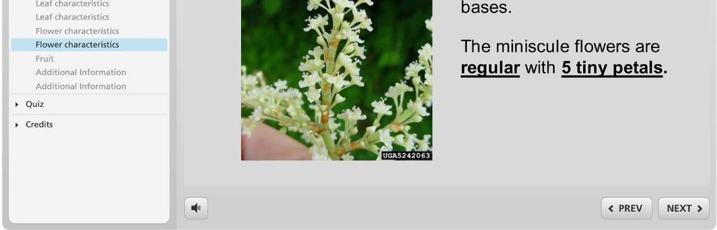
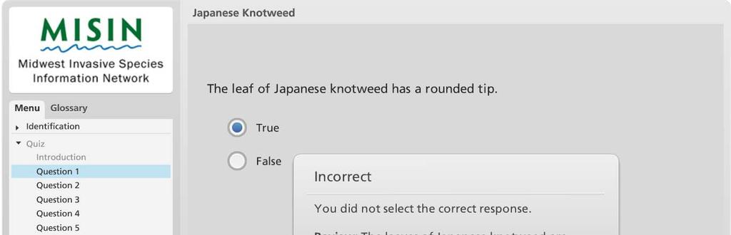
27 MISIN Identification Modules / Details Currently 45 Online Flash based HTML5 tablet supported
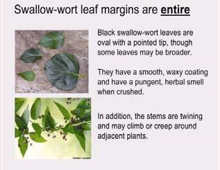
28 Current Species Training Modules Amur honeysuckle Autumn Olive Baby's Breath Bell's Honeysuckle Bishop s goutweed Black alder Black jetbead Black locust Black Swallow Wort Brazilian Water weed Bull Thistle Canada Thistle Carolina Fanwort Common Buckthorn Curly Pondweed Cutleaf teasel Dame s Rocket Eurasian watermilfoil European Frog bit European Privet European Swamp Thistle Flowering Rush Garlic Mustard Glossy Buckthorn Hydrilla Japanese Barberry Japanese hedge parsley Japanese Knotweed Kudzu Morrow's Honeysuckle Multiflora Rose Norway Maple Oriental bittersweet Pale Swallow Wort Parrot feather water milfoil Phragmites Porcelainberry Purple Loosestrife Russian Olive Spotted Knapweed Tatarian Honeysuckle Tree of Heaven Water Lettuce Water Hyacinth Wild Parsnip


29 Multiple Platforms Supported Tablets Desktop Computer

30 MISIN Identification Modules / Quiz


31 MISIN Identification Modules / Quiz

32 MISIN Identification Modules / Quiz

33 MISIN Identification Modules / Quiz

34 MISIN Identification Modules / Quiz

35 MISIN Identification Modules / Quiz

36 MISIN Identification Modules / Quiz


37 MISIN Identification Modules / Quiz
38 MISIN Identification Modules / Quiz Visit the following URL and incorporate these training modules into your web site:
39 Wrapping things up Questions? Join the Conversation / MidwestInvasives


40 Thank You Amos Ziegler Research Scientist Department of Entomology 235B Natural Science Ph: 517/
Invasive Species in Your Backyard
 Invasive Species in Your Backyard Grand Traverse Regional Land Conservancy, Benzie Conservation District, Sleeping Bear Dunes National Lakeshore, Leelanau Conservancy, The Nature Conservancy, Saving Birds
Biodiversity Conservation: Moving Beyond a Shotgun Approach to Managing Invasive Species
 Biodiversity Conservation: Moving Beyond a Shotgun Approach to Managing Invasive Species Phyllis Higman Michigan Natural Features Inventory Mid-Michigan CISMA, Feb. 25, March 4, 2019 Michigan State University
Oneida Lake and Three Mile Bay SLELO-PRISM Early Detection Surveillance
 P a g e 1 St. Lawrence Eastern Lake Ontario Partnership for Regional Invasive Species Management 2018 Field Survey Oneida Lake and Three Mile Bay Early Detection Surveillance June 14 th, 15 th, 20 th,
Responding to Horticulture Inquiries Weeds/Invasive plants Dutchman s breeches battling garlic mustard WEATHER DRIVES PLANT POPULATION DEVELOPMENT
 Responding to Horticulture Inquiries Weeds/Invasive plants Dutchman s breeches battling garlic mustard Extended fall growing season Mark Renz mrenz@wisc.edu fyi.uwex.edu/weedsci WEATHER DRIVES PLANT POPULATION
Meeting the Challenge of Invasive Plants: A Framework for Action
 Meeting the Challenge of Invasive Plants: A Framework for Action prepared for the Michigan Department of Natural Resources Wildlife Division by: Phyllis Higman & Suzan Campbell Michigan Natural Features
Fish Creek Wildlife Management Area
 St. Lawrence Eastern Lake Ontario Partnership for Regional Invasive Species Management Special Note The partners of the SLELO PRISM have identified 24 Priority Conservation Areas on which we conduct early
Dave Williams Liz Schultheis Jen Lau
 Dave Williams Liz Schultheis Jen Lau Goals for today: Discuss invasive species of Michigan, and one of the major hypotheses on their success ERH Provide resources for the classroom that can be used to
Terrestrial Invasive Plants
 Terrestrial Invasive Plants Rules to Control their Sale Gary Fish Maine State Horticulturist gary.fish@maine.gov http://www.maine.gov/dacf/php/horticulture/invasiveplants.shtml History of Invasive Plant
ILLINOIS UPDATE: SPREAD OF INVASIVE PLANTS AND PROJECT UPDATES
 ILLINOIS UPDATE: SPREAD OF INVASIVE PLANTS AND PROJECT UPDATES Karla Gage 1 and Chris Evans 2 1 Southern Illinois University and 2 University of Illinois SPECIES ON THE MOVE JAPANESE STILTGRASS MICROSTEGIUM
Invasive Species: A Threat to Northern Michigan Way of Life
 Invasive Species: A Threat to Northern Michigan Way of Life On a global basis the two great destroyers of biodiversity are, first habitat destruction and, second, invasion by exotic species E.O Wilson
Invasive plant data collection by NRS Forest Inventory and Analysis
 Invasive plant data collection by NRS Forest Inventory and Analysis W. Keith Moser, D.F. Northern Research Station, Forest Inventory and Analysis, Saint Paul, Minnesota Madison, Wisconsin, 24 January 2008
ECOLOGICAL IMPACTS OF INVASIVE SPECIES. on Native Species and Ecosystems
 ECOLOGICAL IMPACTS OF INVASIVE SPECIES I. Competition on Native Species and Ecosystems II. Consumption (invasive species eat native species) III. Other deadly impacts on individuals and populations IV.
Montana s Noxious Weeds: Weeds 101
 Montana s Noxious Weeds: Weeds 101 MODULE 1 Module 1: Introduction Weedy vs. Noxious A weed is: A plant growing where it isn t wanted. Whereas a noxious weed is: A plant growing where it isn t wanted and
The Minnesota Noxious Weed Lists By Category. Holly Nelson Isanti County Noxious and Invasive Weed Unit
 The Minnesota Noxious Weed Lists By Category Holly Nelson Isanti County Noxious and Invasive Weed Unit MINNESOTA STATE STATUES MN STATUES 18.75-18.91 NOXIOUS WEED LAW 18.80 INSPECTORS Subdivision 2 Local
Battle Tactics from Camp Ripley, The War on Invasive Species
 Battle Tactics from Camp Ripley, The War on Invasive Species Kayla Malone maka0811@stcloudstate.edu Camp Ripley, MN Camp Ripley is a 53,000-acre regional training facility for our military, federal, state,
Aquatic Plants of Eastman Pond, Eastman
 Aquatic Plants of Eastman Pond, Eastman State Contact: Amy P. Smagula Limnologist/Exotic Aquatic Plant Program Coordinator 603-271 271-22482248 or asmagula@des.state.nh.us Current status of exotic plant
Aquatic Plants of MESSER POND
 Aquatic Plants of MESSER POND State Contact: Amy P. Smagula Limnologist/Exotic Aquatic Plant Program Coordinator 603-271-2248 or Amy.Smagula@des.nh.gov Overview This slideshow includes four sections aimed
Briggs Lake Water Quality Report 2014
 Briggs Lake Water Quality Report 2014 Seasonal Report for Briggs Lake Green Oak Township, Livingston Co. T1N, R6E, Sec. 3,4 74 Surface Acres 414 Hadley Street Holly, MI 48442 Main Phone: 248-634-8388 Northern
Crystal Lake Aquatic Plants. Dr. George Knoecklein
 Crystal Lake Aquatic Plants Dr. George Knoecklein Things to keep in mind 1. You will not learn it all in one season 2. Start a library of plant keys 3. Begin to get familiar with scientific names 1. In
The Emerging Role of Enterprise GIS in State Forest Agencies
 The Emerging Role of Enterprise GIS in State Forest Agencies Geographic Information System (GIS) A geographic information system (GIS) is a computer software system designed to capture, store, manipulate,
Strategies for Control of Giant Salvinia and Other Invasive Species
 Strategies for Control of Giant Salvinia and Other Invasive Species Projects under consideration for a Caddo Lake Institute grant proposal to the National Fish & Wildlife Foundation Initial Focus is on
GROUND DISTURBANCE AND REVEGETATION GUIDELINES
 GROUND DISTURBANCE AND REVEGETATION GUIDELINES Ravalli County Weed District 329 Airport Road Stevensville, Montana 59870 406-777-5842 kmorris@rc.mt.gov To comply with the MONTANA S COUNTY WEED CONTROL
The Weed Battle. Sage Fitch, Salt Lake County Weed Specialist
 The Weed Battle Noxious and Invasive Weed Management by The Salt Lake County Weed Program and The Bonneville CWMA Sage Fitch, Salt Lake County Weed Specialist Our program & our partners Who are we and
Using Technology to Report Invasive Species in Indiana via EDDMapS and the GLEDN Smartphone/Tablet App
 Using Technology to Report Invasive Species in Indiana via EDDMapS and the GLEDN Smartphone/Tablet App Rebekah D. Wallace, Charles T. Bargeron, and Karan A. Rawlins Background University of Georgia BS
Guide developed by: Chris Acy, Aquatic Invasive Species Coordiantor, Winnebago Waterways Program, Fox-Wolf Watershed Alliance
 Prevent the Spread! Remember to clean off your shoes, boots, waders, clothing, and equipment before leaving each sampling site! Try and remove all mud, debris, seeds, etc. from your shoes! Help stop the
The Revised Minnesota Noxious Weed Law. Anthony Cortilet Minnesota Department of Agriculture Noxious and Invasive Weed Program
 The Revised Minnesota Noxious Weed Law Anthony Cortilet Minnesota Department of Agriculture Noxious and Invasive Weed Program Noxious and Invasive Weed Program Website MN Noxious Weed Law The MN Noxious
ArcGIS Deployment Pattern. Azlina Mahad
 ArcGIS Deployment Pattern Azlina Mahad Agenda Deployment Options Cloud Portal ArcGIS Server Data Publication Mobile System Management Desktop Web Device ArcGIS An Integrated Web GIS Platform Portal Providing
Wildflower, Weed, or Botanical Bully? Method
 Wildflower, Weed, or Botanical Bully? Method Students will visit a weedy area near their school. They will find and observe plants and their surroundings. Back in the classroom, they will identify the
Aquatic Plants of Canaan Street Lake, Canaan
 Aquatic Plants of Canaan Street Lake, Canaan State Contact: Amy P. Smagula Limnologist/Exotic Aquatic Plant Program Coordinator 603-271-2248 or Amy.Smagula@des.nh.gov Current status of exotic plant infestations
CIPWG Workshop on Invasive Species Risk Assessment. June 15, 2017
 CIPWG Workshop on Invasive Species Risk Assessment June 15, 2017 Workshop Objectives develop and assess a quantitative means of evaluating invasive plant species in CT, using a numeric scoring system for
New Hampshire Invasive Plants
 New Hampshire Invasive Plants with diagnostic photographs, and remarks regarding management, ecology, toxicity and removal. SAMPLE PDF WITHOUT LINKS Photos are low resolution. By Martin C. Michener Copyright
Citizen Science Actions AIS Shoreline Survey Blocking Zebra Mussels Ice in, Ice off. Janet Andersen
 Citizen Science Actions AIS Shoreline Survey Blocking Zebra Mussels Ice in, Ice off Janet Andersen Shoreline search for new Aquatic Invasive Plants NYS DEC NYSFOLA Janet Andersen Shoreline Search Topics
Leo Donovall PISC Coordinator/Survey Entomologist
 Leo Donovall PISC Coordinator/Survey Entomologist Executive Order 2004-1 Recognized the Commonwealth would benefit from the advice and counsel of an official body of natural resource managers, policy makers,
FOURTEEN YEARS OF SPATIAL DATA FROM PLANTS OF CONCERN: WHAT ARE WE LEARNING?
 FOURTEEN YEARS OF SPATIAL DATA FROM PLANTS OF CONCERN: WHAT ARE WE LEARNING? Rachel Goad, Manager, Plants of Concern Shannon Still, Postdoctoral Researcher, Chicago Botanic Garden Jeremie Fant, Conservation
Invasive Species Management: Some Particulars
 Invasive Species Management: Some Particulars Art Gover Penn State University Wildland Weed Management College of Agricultural Sciences plantscience.psu.edu/wildland Acknowledgement PA DCNR, Bureau of
Walk with Weeds- Noxious Weed s Backyard or Yours?
 Walk with Weeds- Noxious Weed s Backyard or Yours? Created by: Kim Schumacher Subject: Science, Language Arts Time Required: 30-minutes (1 class period) Date: Grade Level: 3 rd & 4 th Standards: Reading:
Introduction to ArcGIS Server - Creating and Using GIS Services. Mark Ho Instructor Washington, DC
 Introduction to ArcGIS Server - Creating and Using GIS Services Mark Ho Instructor Washington, DC Technical Workshop Road Map Product overview Building server applications GIS services Developer Help resources
The FNAI Invasive Plants Program
 The FNAI Invasive Plants Program What we do and how we can help the Northwest FL CISMA Frank Price Invasive Plants Program Manager Staff of 32 Part of FUS and the NatureServe network 100% contract funded
Invasive Plant Identification for Regional Mapping
 Invasive Plant Identification for Regional Mapping Kerrie L. Kyde Invasive Plant Ecologist MD DNR Natural Heritage Program kerrie.kyde@maryland.gov Statewide Eyes Training for Central Maryland Trees Norway
Invasive Plant Identification for Regional Mapping
 Invasive Plant Identification for Regional Mapping Kerrie L. Kyde Invasive Plant Ecologist MD DNR Natural Heritage Program kerrie.kyde@maryland.gov Statewide Eyes Training for Western Maryland Trees Norway
Spatial Data Infrastructure Concepts and Components. Douglas Nebert U.S. Federal Geographic Data Committee Secretariat
 Spatial Data Infrastructure Concepts and Components Douglas Nebert U.S. Federal Geographic Data Committee Secretariat August 2009 What is a Spatial Data Infrastructure (SDI)? The SDI provides a basis for
New Invasives and Other Weeds to Worry About. Clallam County Noxious Weed Control Program
 New Invasives and Other Weeds to Worry About Clallam County Noxious Weed Control Program What s wrong with Noxious Weeds? Numerous Impacts Reduce crop value or production Pose hazard to humans and animals
NEW YORK STATE INVASIVE PLANT LIST
 NEW YORK STATE INVASIVE PLANT LIST The list is referenced in the Stormwater Practices General Maintenance Cards (Appendix 1).* Images assembled by the Stormwater Coalition of Albany County: swcoalition@albanycounty.com
Outline 1/7/2016 ILLINOIS EXOTIC WEED ACT: REGULATIONS AND RECENT UPDATES. Illinois Exotic Weed Act (525 ILCS 10/)
") Outline ILLINOIS EXOTIC WEED ACT: REGULATIONS AND RECENT UPDATES Illinois Exotic Weed Act Purpose Legal Restrictions Previous list of species Recent update New species added Identification Chris Evans,
Outline ILLINOIS EXOTIC WEED ACT: REGULATIONS AND RECENT UPDATES Illinois Exotic Weed Act Purpose Legal Restrictions Previous list of species Recent update New species added Identification Chris Evans,
SLELO PRISM s Invasive Species Volunteer Surveillance Network Guide for Aquatic Plants
 SLELO PRISM s Invasive Species Volunteer Surveillance Network Guide for Aquatic Plants 2018 ST. LAWRENCE EASTERN LAKE ONTARIO PARTNERSHIP FOR REGIONAL INVASIVE SPECIES MANAGEMENT To learn more visit www.sleloinvasvies.org
Geospatial Decision Support Tools for Planning of Marine Protected Areas in California
 Geospatial Decision Support Tools for Planning of Marine Protected Areas in California WILL MCCLINTOCK (UNIVERSITY OF CALIFORNIA SANTA BARBARA), MATT MERRIFIELD (THE NATURE CONSERVANCY), SOPHIE DE BEUKELAER
Aquatic Weed Identification and Control
 Aquatic Weed Identification and Control David Kratville, Environmental Scientist Integrated Pest Control Branch California Department of Food and Agriculture Emergent/Floating Aquatic Weed ID Riparian
Geo-enabling a Transactional Real Estate Management System A case study from the Minnesota Dept. of Transportation
 Geo-enabling a Transactional Real Estate Management System A case study from the Minnesota Dept. of Transportation Michael Terner Executive Vice President Co-author and Project Manager Andy Buck Overview
3325 Franklin Rd. or Bloomfield Hills, MI 48302
 TEACHING UNIT Plant Ecology-Global Issues Dan Badgley telephone(248)341-6487(daytime) E.L.Johnson Nature Center email dvbadgley@comcast.net 3325 Franklin Rd. or dbadgley@bloomfield.org Bloomfield Hills,
Terrestrial Invasive Species - An Overview
 Terrestrial Invasive Species - An Overview Angie Ambourn Entomologist March 6, 2018 Optional Tagline Goes Here mn.gov/websiteurl Definition of Invasive species non-native to the ecosystem under consideration;
Nebraska s Noxious Weeds
 Nebraska s Noxious Weeds 1. Canada Thistle - 1873 2. Musk Thistle - 1962 3. Leafy Spurge - 1962 4. Plumeless Thistle - 1975 5. Spotted Knapweed - 1992 6. Diffuse Knapweed - 1992 7. Purple Loosestrife January
Wisconsin s Invasive Species Classification Assessment and Rule
 Wisconsin s Invasive Species Classification Assessment and Rule The Process Legislature gave WIDNR authority to create an invasive species classification system. Legislature also created Wis. Council on
Assessing Invasive Plants in Ohio: The Process and Progress of the Ohio Invasive Plants Council Assessment Program
 Assessing Invasive Plants in Ohio: The Process and Progress of the Ohio Invasive Plants Council Assessment Program Theresa M. Culley University of Cincinnati Acknowledgements Karen Adair Tom Arbour John
INVASIVE PLANTS: NOXIOUS ALIEN INVADERS Q & A
 INVASIVE PLANTS: NOXIOUS ALIEN INVADERS Q & A (Compiled by Roslyn Moorhead and Anita Caveney) The purpose of this article is to inform people, especially Londoners, about invasive plant species, and encourage
Weeds: the Great Biodiaspora. Weeds: the Great Biodiaspora
 Weed: A plant species (or any organism) not in its normal geographic distribution, spread by human activities, and usually with some negative impact to humans and/or native flora/vegetation/fauna What
Regione Umbria. ESRI EMEA User Conference 2010 Rome, October 27th 2010
 Direzione Ambiente, Territorio e Infrastrutture Servizio Informatico/Informativo: geografico, ambientale e territoriale ESRI EMEA User Conference 2010 Rome, October 27th 2010 Arch. Ambra Ciarapica, Dott.
Lessons Learned from Fish Spawning Reef Restoration in the St. Clair Detroit River System. Photo Credit: Adam Lintz
 Lessons Learned from Fish Spawning Reef Restoration in the St. Clair Detroit River System Photo Credit: Adam Lintz Outline and Presenters Jennifer Read, University of Michigan Water Center Introduction
Using Big Interagency Databases to Identify Climate Refugia for Idaho s Species of Concern
 Using Big Interagency Databases to Identify Climate Refugia for Idaho s Species of Concern What is a Climate Refugia? habitat that supports a locally reproducing population [or key life history stage]
ICAN Great Lakes 2010 Workshop
 ICAN Great Lakes 2010 Workshop Chris Cortina Maryland s Chesapeake & Coastal Program MD Department of Natural Resources Maryland s Coastal Atlas: What is it? The Coastal Atlas is an online mapping and
a. Identify the genus and species: (1 pt) b. Explain how and why this species was introduced to America: (2 pts)
 b. Explain how and why this species was introduced to America: (2 pts)") 1 NOTE: ONE SECTION OF THIS TEST REQUIRES A CALCULATOR Section 1: a. Identify the genus and species: (1 pt) b. Explain how and why this species was introduced to America: (2 pts) c. Explain why this species
1 NOTE: ONE SECTION OF THIS TEST REQUIRES A CALCULATOR Section 1: a. Identify the genus and species: (1 pt) b. Explain how and why this species was introduced to America: (2 pts) c. Explain why this species
Poison vine (Derris elliptica)
") Poison vine (Derris elliptica) An Alien Plant Report Prepared by: Forest Starr, Kim Martz and Lloyd Loope United States Geological Survey Biological Resources Division In cooperation with: American Water
Poison vine (Derris elliptica) An Alien Plant Report Prepared by: Forest Starr, Kim Martz and Lloyd Loope United States Geological Survey Biological Resources Division In cooperation with: American Water
Office of Technology Partnerships GIS Collaboration
 Office of Technology Partnerships GIS Collaboration State GIS Update April 21, 2017 Mark Holmes, GISP Outline MGF Upgrade Project Census Programs Imagery Update LiDAR Update Open Discussion 2 MGF Background
USGS Nonindigenous Aquatic Species Flood and Storm Tracker. (NAS FaST) Maps
 Maps") USGS Nonindigenous Aquatic Species Flood and Storm Tracker Wesley M. Daniel 1 U.S. Department of the Interior U.S. Geological Survey (NAS FaST) Maps Pam Fuller 2 ; Matt Neilson 2 ; and Ian Pfingsten 1
USGS Nonindigenous Aquatic Species Flood and Storm Tracker Wesley M. Daniel 1 U.S. Department of the Interior U.S. Geological Survey (NAS FaST) Maps Pam Fuller 2 ; Matt Neilson 2 ; and Ian Pfingsten 1
Water Atlas Overview. Myakka River Management Coordinating Council June 22, 2012 Englewood, Florida
 Water Atlas Overview Myakka River Management Coordinating Council June 22, 2012 Englewood, Florida What is the Water Atlas? A data warehouse A set of interactive maps A collection of tools for viewing/analyzing
Overview. Project Background Project Approach: Content and Application Development Application Demonstration Future Developments
 Overview Project Background Project Approach: Content and Application Development Application Demonstration Future Developments Southeast Pressures: Continued Population Growth Transportation Corridors
Spatial Data Availability Energizes Florida s Citizens
 NASCIO 2016 Recognition Awards Nomination Spatial Data Availability Energizes Florida s Citizens State of Florida Agency for State Technology & Department of Environmental Protection Category: ICT Innovations
Natural Shoreline Landscapes on Michigan Inland Lakes
 Natural Shoreline Landscapes on Michigan Inland Lakes Excerpts from Chapters 2 and 3 Photo Photo by Jane by Jane Herbert Herbert Session topics Characteristics of natural and altered shorelines Lakes,
Optimizing Field Operations
 Optimizing Field Operations with ArcGIS Ismael Chivite Jeff Shaner Chris Lesueur Agenda Notes from the field ArcGIS apps Concepts Demonstrations Q&A Who are we? Ismael Chivite Jeff Shaner Chris LeSueur
Doing Things Differently: Tracking Invasive Exotic Plants in the Florida Park Service
 Florida Park Service Doing Things Differently: Tracking Invasive Exotic Plants in the Florida Park Service 21 May 2013 The Big Picture 171 State Parks and Trails across 5 Districts ~785,000 Acres Almost
A Regional Database Tracking Fire Footprint Each Year within the South Atlantic Region: Current Database Description and Future Directions
 A Regional Database Tracking Fire Footprint Each Year within the South Atlantic Region: Current Database Description and Future Directions Last Updated on September 30, 2018 Contributors: NatureServe,
ArcGIS Platform For NSOs
 ArcGIS Platform For NSOs Applying GIS and Spatial Thinking to Official Statistics Esri UC 2014 Demo Theater Applying GIS at the NSO Generic Statistical Business Process Model (GSBPM) 1 Specify Needs 2
KEEPING DATA ACCURATE WITH THOSE WHO KNOW BEST. Adam Breznicky, GIS Analyst; TPP
 KEEPING DATA ACCURATE WITH THOSE WHO KNOW BEST Adam Breznicky, GIS Analyst; TPP Table of Contents 1 TxDOT TPP Mapping Group 3-6 2 County Road Inventory Project 7-10 3 Design & Goals 11-15 4 The Application
Pan-Arctic Digital Elevation Map (Pan-Arctic DEM)
") Memorandum to CAFF Board 07/28/2017 BACKGROUND: Pan-Arctic Digital Elevation Map (Pan-Arctic DEM) ArcticDEM is a National Geospatial-Intelligence Agency (NGA)-National Science Foundation (NSF) publicprivate
Memorandum to CAFF Board 07/28/2017 BACKGROUND: Pan-Arctic Digital Elevation Map (Pan-Arctic DEM) ArcticDEM is a National Geospatial-Intelligence Agency (NGA)-National Science Foundation (NSF) publicprivate
Introducing the. a partnership of
 Introducing the a partnership of Background Need for online atlas identified by managers and researchers to make coastal data available Shoreline data Ocean and coastal resources Sea-level rise potential
Big-Geo-Data EHR Infrastructure Development for On-Demand Analytics
 Big-Geo-Data EHR Infrastructure Development for On-Demand Analytics Sohayla Pruitt, MA Senior Geospatial Scientist Duke Medicine DUHS DHTS EIM HIRS Page 1 Institute of Medicine, World Health Organization,
GIS Options RELU Upland Moorland Scoping Study Project CCG/SoG Working Paper, February 2005 Andy Turner
 GIS Options RELU Upland Moorland Scoping Study Project CCG/SoG Working Paper, February 2005 Andy Turner 1. Introduction This working paper outlines some Geographical Information System (GIS) options for
Internet GIS Sites. 2 OakMapper webgis Application
 Internet GIS Sites # Name URL Description 1 City of Sugar Land http://www.sugarlandtx.gov/index.htm It is a city in Texas with 65,000 Residents. The City of Sugar Land, Texas, provides ArcIMS-based maps
DRRM in the Philippines: DRRM Projects, Geoportals and Socio-Economic Integration
 Regional workshop on Geo-referenced information system for improving disaster risk preparedness and management in Asia and the Pacific 26-27 June 2014, UNCC, Bangkok, Thailand DRRM in the Philippines:
1) make sure folks know what s available in terms of geospatial data and resources that could contribute to their decision support toolkits;
 make sure folks know what s available in terms of geospatial data and resources that could contribute to their decision support toolkits;") Introduction 1 2001 It was born out of the recognition that several of the regions prominent resource management agencies have similar, if not shared, requirements for GIS data. Some of the underlying
Introduction 1 2001 It was born out of the recognition that several of the regions prominent resource management agencies have similar, if not shared, requirements for GIS data. Some of the underlying
Rainfall-River Forecasting: Overview of NOAA s Role, Responsibilities, and Services
 Dr. Thomas Graziano Chief Hydrologic Services Division NWS Headquarters Steve Buan Service Coordination Hydrologist NWS North Central River Forecast Center Rainfall-River Forecasting: Overview of NOAA
Creating a Staff Development Plan with Esri
 Creating a Staff Development Plan with Esri Michael Green David Schneider Guest Presenter: Shane Feirer, University of California Esri UC 2014 Technical Workshop Agenda What is a Staff Development Plan?
Geography for the 2020 Round of Census
 Boundaries Key Census Data EA Id Population Male Female EA Id Area EA Id Num HH Avg HH size Geography for the 2020 Round of Census Linda Peters, Esri lpeters@esri.com Integration of Statistical and Geospatial
Invasive Plants Watch List: 2018
 Invasive Plants Watch List: 2018 These lists were developed to provide a more region-based list of invasive plants to be on the watch for. Counties were divided up into ecoregions based on the Nebraska
AUTOMATED ONLINE ECOLOGICAL MODELING AND EVALUATION FOR EVERGLADES MANAGEMENT AND RESTORATION
 AUTOMATED ONLINE ECOLOGICAL MODELING AND EVALUATION FOR EVERGLADES MANAGEMENT AND RESTORATION Leonard Pearlstine 1 Suresh Goldconda 2 Kevin Suir 3 Alicia LoGalbo 1 Craig Conzelmann 3 Janice Parsons 1 1
Brent Hanson Hanson s Garden Village
 Brent Hanson Hanson s Garden Village - NR 40 - Wisconsin s Invasive Species Identification, Classification and Control Rule Effective date: September 1, 2009 Nonnative species whose introduction causes
Building a National Data Repository
 Building a National Data Repository Mladen Stojic, Vice President - Geospatial 1/30/2013 2012 Intergraph Corporation 1 Information has meaning and gives power only when shared and distributed. Information,
Appendix. Exhibit A 2007 Invasive Plants List
 Appendix Exhibit A 2007 Invasive Plants List The following page contains the most recently updated Non-Native Invasive Plant List for the Huron-Manistee National Forest. The species on this list have been
HIGH RESOLUTION BASE MAP: A CASE STUDY OF JNTUH-HYDERABAD CAMPUS
 HIGH RESOLUTION BASE MAP: A CASE STUDY OF JNTUH-HYDERABAD CAMPUS K.Manjula Vani, Abhinay Reddy, J. Venkatesh, Ballu Harish and R.S. Dwivedi ABSTRACT The proposed work High Resolution Base map: A Case study
Distribution of Hydrilla and Giant Salvinia in Mississippi in 2005
 An Annual Report to the Mississippi Bureau of Plant Industry for 2005 John D. Madsen, Ryan M. Wersal, and Wilfredo Robles GeoResources Institute and Department of Plant and Soil Science Mississippi State
OUTREACH TERC.UCDAVIS.EDU
 E D U C AT I O N A N D OUTREACH 12 TERC education and outreach Part of TERC s mission is education and outreach. Our public, K-12, teacher professional development, and volunteer programs are designed
Why Should We Care About Invasive Species?
 Why Should We Care About Invasive Species? Dr. Vanessa Beauchamp Towson University Department of Biological Sciences Maryland Native Plant Society Fall Conference September 15, 2018 Exotic Exotic Species
Impact Policies Enabling Value Enhancement of Geospatial Information in Canadian Economy and Society
 1 Impact Policies Enabling Value Enhancement of Geospatial Information in Canadian Economy and Society May 26, 2015 Prashant Shukle, Director General Canada Centre for Mapping and Earth Observation Increased
TreesCount! NYC Innovation & Emerging Technologies Workgroup. Culture of Innovation in NYC Government Series. Session will begin at 1:00 pm
 NYC Innovation & Emerging Technologies Workgroup NYC Innovation & Emerging Technologies Workgroup Presents: Culture of Innovation in NYC Government Series TreesCount! Session will begin at 1:00 pm 1 NYC
for Effective Land Administration
 Role of Geospatial Technology in Land Information System(LIS) for Effective Land Administration Dr. Deb Jyoti Pal Sections Role of GIS in Land Records Proposed Work Flow Case Studies Role of GIS Creating
Kootenai River Habitat Restoration Program Update
 Kootenai River Habitat Restoration Program Update Kootenai Tribe of Idaho Kootenai Valley Resource Initiative November 19, 2012 Bonners Ferry, Idaho Changes to Kootenai Basin Beaver trapping Floodplain
Introduction to ArcGIS Server Development
 Introduction to ArcGIS Server Development Kevin Deege,, Rob Burke, Kelly Hutchins, and Sathya Prasad ESRI Developer Summit 2008 1 Schedule Introduction to ArcGIS Server Rob and Kevin Questions Break 2:15
Arboretum Explorer: Using GIS to map the Arnold Arboretum
 Arboretum Explorer: Using GIS to map the Arnold Arboretum Donna Tremonte, Arnold Arboretum of Harvard University 2015 Esri User Conference (UC), July 22, 2015 http://arboretum.harvard.edu/explorer Mission
MAPS MAPS MAPS.
 www.atozmapsonline.com MODERN MAPS MAPS MAPS MAPS AtoZ Maps Online TM is the world s most comprehensive collection of royalty-free downloadable maps for schools, academic institutions, and public libraries.
MAPPS 2012 Geospatial Products and Services Excellence Awards Awards Entry Form
 MAPPS 2012 Geospatial Products and Services Excellence Awards 2012 Awards Entry Form Please include a copy of this document with the project/product submission Entry Information Submission Number: 1741558
The GIS Path Forward Saskatchewan s Geomatics Strategic Plan
 The GIS Path Forward Saskatchewan s Geomatics Strategic Plan John Potter, SK Ministry of Central Services Office of Geomatics Coordination Sept.17/13 Table of Contents 1. 2011-2016, Geomatics Strategic