REPORT ON SEA LEVEL STATION IN THE PHILIPPINES
|
|
|
- Lenard Murphy
- 5 years ago
- Views:
Transcription


1 NATIONAL MAPPING AND RESOURCE INFORMATION AUTHORITY HYDROGRAPHY BRANCH REPORT ON SEA LEVEL STATION IN THE PHILIPPINES ENGR. RAUL S. CAPISTRANO


2


3


4
5


6 PHYSICAL OCEANOGRAPHY DIVISION OCEANOGRAPHIC SURVEY SECTION OCEANOGRAPHIC DATA PROCESSING AND ANALYSIS SECTION OCEANOGRAPHIC DATABASE MANAGEMENT SECTION 47 TIDE STATIONS


7
8 OCEANOGRAPHIC SURVEY SECTION


9 OCEANOGRAPHIC SURVEY SECTION Installation of tide gauge equipment
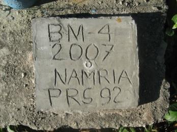
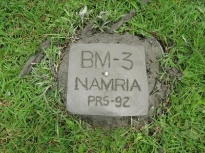


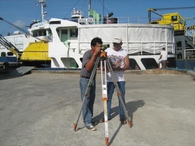

10 OCEANOGRAPHIC SURVEY SECTION Tidal Leveling


11 OCEANOGRAPHIC SURVEY SECTION Calibration of tide gauge and reading of tide staff

12 OCEANOGRAPHIC DATA PROCESSING AND ANALYSIS SECTION

")
 MEAN")
 MEAN LOWER LOW")

13 TIDE PROCESSING AND ANALYSIS SECTION Computation of tidal datums HIGHEST OBSERVED WATER LEVEL MEAN SEA LEVEL (MSL) MEAN TIDE LEVEL (MTL) MEAN HIGHER HIGH WATER (MHHW) MEAN HIGH WATER (MHW) MEAN LOW WATER (MLW) MEAN LOWER LOW WATER (MLLW) LOWEST TOBSERVED WATER LEVEL Paper chart/ marigram Tidal datum

14 OCEANOGRAPHIC DATA PROCESSING AND ANALYSIS SECTION Sea Level Variations

15 TIDE PROCESSING AND ANALYSIS SECTION Storm surges effect of Typhoon Pedring

16 OCEANOGRAPHIC DATA PROCESSING AND ANALYSIS SECTION THE TSUNAMI EFFECT OF SENDAI EARTHQUAKE IN THE PHILIPPINES
17

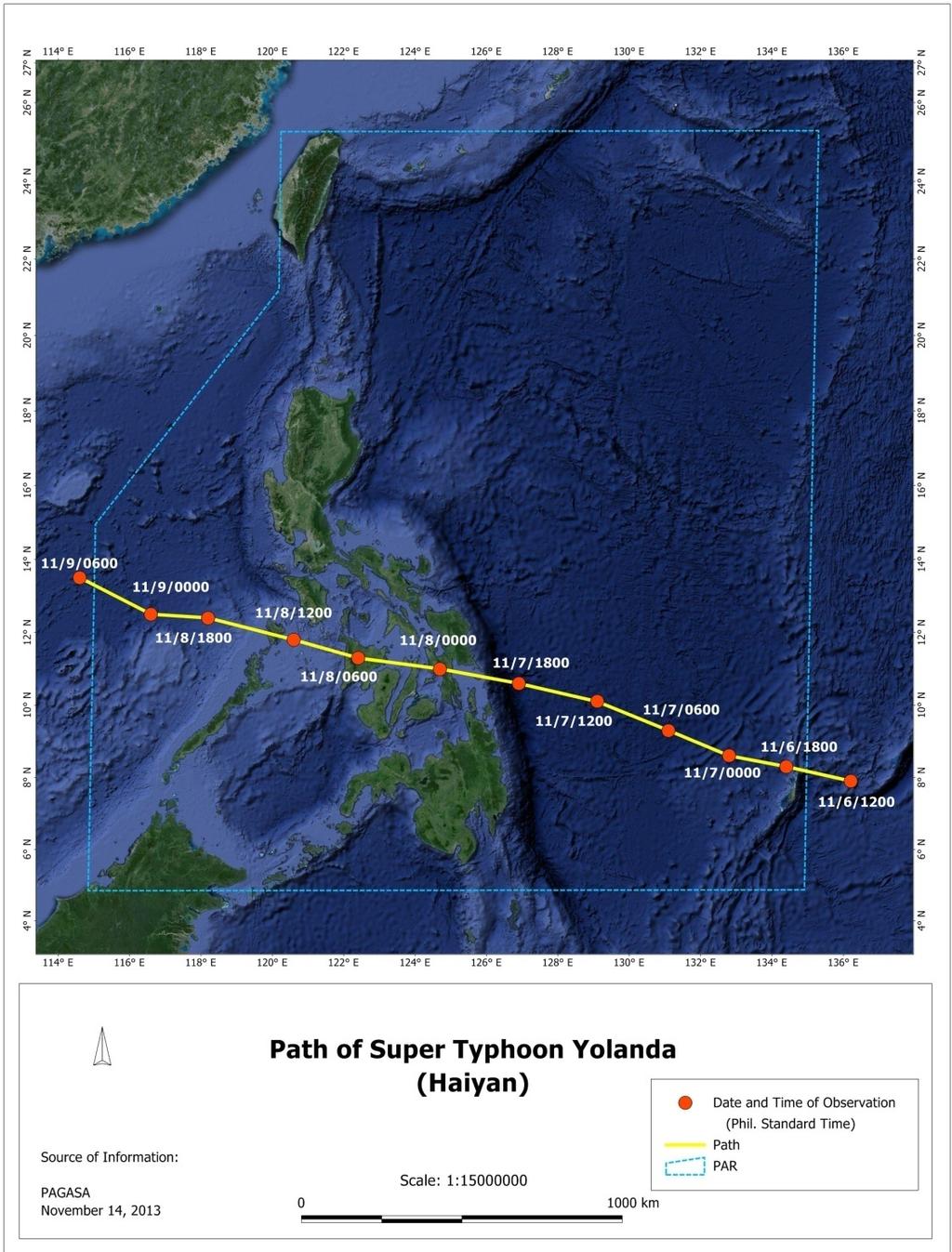
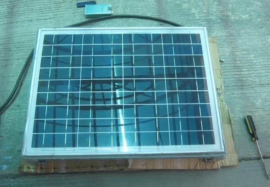
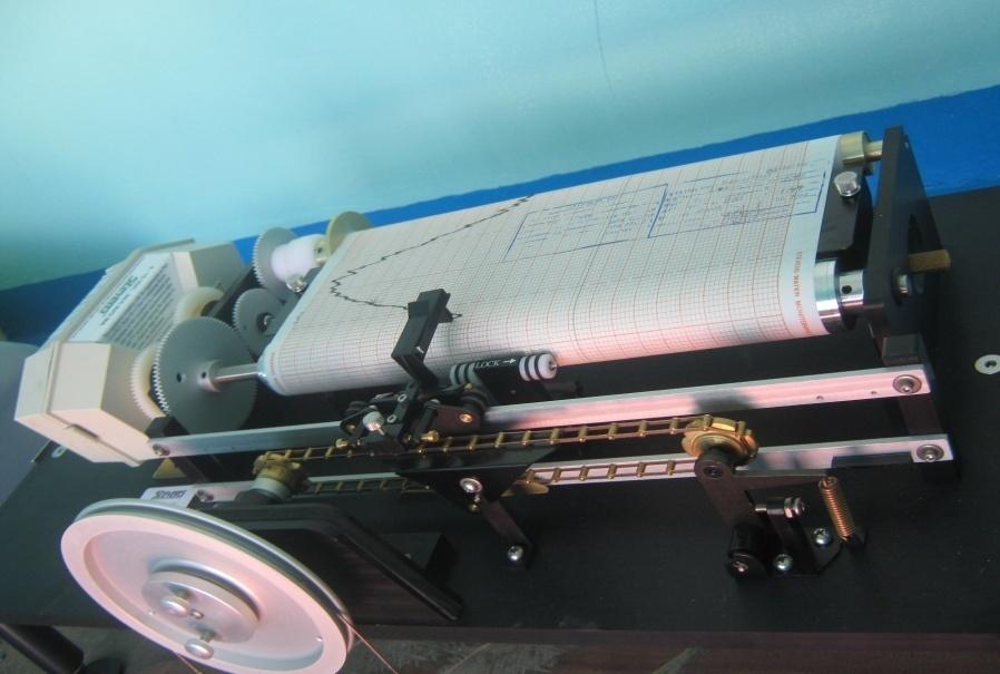
18 Time = 0530H of November 8,2013 Actual Height at its peak = 3.494m Surge Measured Rise = 1.854m Predicted Height = 1.64m First storm surges hit Guiuan, Eastern Samar OBSERVED TIDAL HEIGHTS IN GUIUAN, EASTERN SAMAR

19 GRAPH OF ACTUAL AND PREDICTED TIDAL HEIGHTS IN TACLOBAN FROM 0000H of 06 NOV. TO 0710H of 08 NOV. 2013

20 TIDE PROCESSING AND ANALYSIS SECTION PUBLICATIONS OF TIDE AND CURRENT TABLES 2000 COPIES

21 OCEANOGRAPHIC DATABASE MANAGEMENT SECTION

22 UPDATING OF TIDAL INFORMATION OCEANOGRAPHIC DATABASE MANAGEMENT SECTION MEAN HIGH WATER INTERVAL MEAN HIGHER HIGH WATER MEAN TIDE LEVEL EXTREME LOW WATER TIDAL INFORMATION OF NAUTICAL CHARTS

23 TIDE STATIONS NETWORK IN THE PHILIPPINES


24 BASCO TELEMETRY STATIONS REAL TIME TIDE STATIONS CURRIMAO SAN VICENTE NEAR-REAL TIME TIDE STATIONS PROPOSED LOCAL TELEMETRY STATIONS SAN FERNANDO SUBIC MANILA LUBANG MAMBURAOI BALER REAL PORT JOSE PANGANIBAN MARIVELES BATANGAS VIRAC LEGAZPI MASBATEI SAN JOSE NORTHERN SAMAR EL NIDO SAN JOSE BUENAVISTA GUIUAN BALINTANG PUERTO PRINCESA CEBU SURIGAO TANDAG BROOKES POINT PAGADIAN ZAMBOANGA MATI DAVAO BONGAO GENERAL SANTOS
25 REAL TIME TIDE STATIONS REGIONAL INTEGRATED MULTI-HAZARD EARLY WARNING SYSTEM FOR AFRICA (RIMES STATIONS) CURRIMAO LUBANG GLOBAL SEA LEVEL STATION SYSTEM (GLOSS STATIONS) MANILA DAVAO SUBIC LEGAZPI NOTE: ALL STATIONS ARE SUPPORTED WITH THE 1. INTERGOVERNMENTAL OCEANOGRAPHIC COMMISSION (IOC) 2. GLOBAL SEA LEVEL OBSERVING SYSTEM (GLOSS) 3. THE UNIVERSITY OF HAWAII SEA LEVEL CENTER (UHSLC)


26 LOCAL TELEMETRY STATIONS TIDE STATION COMMUNICATION ANTENNA COMPUTER SERVER TIDAL DATA WORK STATIONS


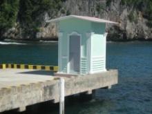
27 TYPICAL TIDE STATION

28 SEA LEVEL INSTRUMENTS OTT STRIP CHART WATER LEVEL AND OTT THALIMEDES DATA LOGGER

29 SEA LEVEL INSTRUMENTS COMMUNICATIONS: RECORDING DEVICE LCD DISPLAY OTT THALIMEDES DATA LOGGER


30 STEVENS ANALOGUE WATER LEVEL RECORDER AND AXYS DIGITAL DATA LOGGER SEA LEVEL INSTRUMENTS


31 SEA LEVEL INSTRUMENTS STEVENS ANALOGUE WATER LEVEL RECORDER AND AXYS DIGITAL DATA LOGGER

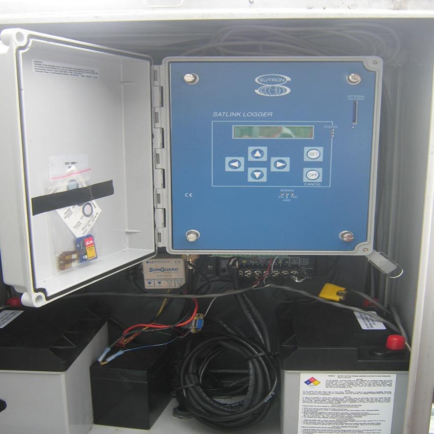

32 SEA LEVEL INSTRUMENTS SUTRON MULTI-PARAMETER SENSOR TIDE STATION

33 SEA LEVEL INSTRUMENTS SUTRON LAYOUT SYSTEMS


34 SEA LEVEL INSTRUMENTS STS PORTABLE TIDE GAUGE PORTABE WAVE AND TIDE GAUGE


 SAN FERNANDO")


35 TIDE STATIONS IN THE PHILIPPINES SAN VICENTE BASCO EXISTING TIDE STATIONS CURRIMAO REAL TIME TELEMETRY STATIONS (/WMO/ PTWC AND ADPC) SAN FERNANDO LOCAL TELEMETRY STATIONS OPERATIONAL PROPOSED LOCAL REAL TIME TELEMETRY SUBIC STATIONS PROPOSED ADDITIONAL MANILA TIDE STATIONS CALAPAN REAL BALER PORT JOSE PANGANIBAN LEGAZPI VIRAC BALANACAN BULAN LUBANG EL NIDO CORON CATICLAN BATANGAS MAMBURAO ROMBLON CATARMAN CATBALOGAN PULUPANDAN TACLOBAN MASBATE BALINTANG PUERTO PRINCESA SAN JOSE ANTIQUE CEBU SURIGAO GUIUAN (UPGRADING) TANDAG BROOKES POINT DIPOLOG MATI DUMAGUETE PAGADIAN ZAMBOANGA PORT KALAMANSIG GEN SAN CAMIGUIN BONGAO DAVAO CAGAYAN DE ORO TAGBILARAN
36 1. Intergovernmental Oceanographic Commission (IOC) 2. Global Sea Level Observing System (GLOSS) 3. Permanent Service for Mean Sea Level (PSMSL) 4. University of Hawaii Sea Level Center (UHSLC) 5. Pacific Tsunami Warning Center (PTWC) 6. Regional Integrated Multi-hazard Early Warning System for Africa and Asia (RIMES)
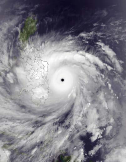
TYPHOON HAIYAN. Known as typhoon Yolanda in the Philippines. Most powerful storm to make landfall in recorded history
 TYPHOON HAIYAN Known as typhoon Yolanda in the Philippines Most powerful storm to make landfall in recorded history Worst hit provinces: Leyte and Eastern Samar with a combined population of 2.3 M Experienced
Satellite Data Utilization and Meteorological Hazard Prevention In the Philippines
 Joint Integrated Global Water Cycle Observing(IGWCO)/ Coordinated Enhanced Observing Period (CEOP) Workshop 28 Feb. 4 March 2005, Tokyo, Japan Satellite Data Utilization and Meteorological Hazard Prevention
GPM Data Utilization (Philippines)
") 7 th GPM International Planning Workshop December 5-7, 2007 Tokyo, Japan GPM Data Utilization (Philippines) Flaviana Hilario Philippine Atmospheric, Geophysical & Astronomical Services Administration (PAGASA)
7 th GPM International Planning Workshop December 5-7, 2007 Tokyo, Japan GPM Data Utilization (Philippines) Flaviana Hilario Philippine Atmospheric, Geophysical & Astronomical Services Administration (PAGASA)
Charles Magori. Status Report of GLOSS Tide Gauges in Kenya
 GLOSS Group of Experts Meeting February 2005 Charles Magori Introduction Status Report of GLOSS Tide Gauges in Kenya There is growing concern about the rise in mean sea level around the globe. To address
Sea Level Monitoring and the GLOSS Programme
 Sea Level Monitoring and the GLOSS Programme Philip L. Woodworth Permanent Service for Mean Sea Level Proudman Oceanographic Laboratory, UK Port Meteorological Officers Meeting, IMO, 25 July 2003 www.pol.ac.uk
September 2013 R. E. E. Licensure Examination
 September 2013 R. E. E. Licensure Examination The performance of schools in the September 2013 R. E. E. Licensure Examination in alphabetical order as per R.A. 8981 otherwise known as PRC Modernization
REPORT ON SEA LEVEL MEASUREMENT FOR GHANA
 20TH SEPTEMBER 2006 REPORT ON SEA LEVEL MEASUREMENT FOR GHANA Emmanuel K. Nkebi 1 1 Survey Department of Ghana, P. O. Box CT903, Accra Tel: 233 21 777 334 Fax : 233 21 765687 E-mail: survey@ghana.com E-mail:eknkebi@yahoo.com
The Global Sea Level Observing System (GLOSS) Andrew Willmott
 Andrew Willmott") The Global Sea Level Observing System (GLOSS) Andrew Willmott A Big Scientific Issue Sea Level Rise The rate of global mean sea level rise increased between the 19 th and 20 th century MSL rose by 1-2
The Global Sea Level Observing System (GLOSS) Andrew Willmott A Big Scientific Issue Sea Level Rise The rate of global mean sea level rise increased between the 19 th and 20 th century MSL rose by 1-2
Earth Observation & forecasting Storm Surges in the North Western Pacific. Mr. Nadao Kohno Japan Meteorological Agency
 Earth Observation & forecasting Storm Surges in the North Western Pacific Mr. Nadao Kohno Japan Meteorological Agency Lesson Outline Introduction JMA s responsibility and work as a RSMC, Tokyo Typhoon
2014/2/25. Earth Observation & forecasting Storm Surges in the North Western Pacific. Lesson Outline. RSMC Tokyo Typhoon Center.
 Earth Observation & forecasting Storm Surges in the North Western Pacific Mr. Nadao Kohno Japan Meteorological Agency Lesson Outline Introduction JMA s responsibility and work as a RSMC, Tokyo Typhoon
November 2012 Civil Engineer Licensure Examination
 November 2012 Civil Engineer Licensure Examination The performance of schools in the November 2012 Civil Engineer Licensure Examination in alphabetical order as per R.A. 8981 otherwise known as PRC Modernization
National Report of New Zealand
 National Report of New Zealand Prepared for GLOSS Training Course Tokyo May 2006 Glen Rowe Data Analyst Hydrographic Services Land Information New Zealand National Office 160 Lambton Quay Wellington New
DATE / DAY # REGION BRANCH NAME BANKING SCHEDULE 02 JAN (SAT) 1 North MM Camarin Road - Caloocan 1:00PM - 4:00PM 2 North MM West Triangle 9:00AM -
 1 North MM Camarin Road - Caloocan 1:00PM - 4:00PM 2 North MM West Triangle 9:00AM -") DATE / DAY # REGION BRANCH NAME BANKING SCHEDULE 02 JAN (SAT) 1 North MM Camarin Road - Caloocan 1:00PM - 4:00PM 2 North MM West Triangle 9:00AM - 12:00NN 3 North MM West Avenue 9:00AM - 12:00NN 4 North
DATE / DAY # REGION BRANCH NAME BANKING SCHEDULE 02 JAN (SAT) 1 North MM Camarin Road - Caloocan 1:00PM - 4:00PM 2 North MM West Triangle 9:00AM - 12:00NN 3 North MM West Avenue 9:00AM - 12:00NN 4 North
Current tsunami research activities in the Philippines
 DOST PHIVOLCS Current tsunami research activities in the Philippines Graciano P. Yumul, Jr. 1,2, Carla B. Dimalanta 1 and Bart Bautista 3 1 National Institute of Geological Sciences, University of the
Location. Datum. Survey. information. Etrometa. Step Gauge. Description. relative to Herne Bay is -2.72m. The site new level.
 Tide Gauge Location OS: 616895E 169377N WGS84: Latitude: 51 o 22.919196 N Longitude: 01 o 6.9335907 E Instrument Type Etrometa Step Gauge Benchmarks Benchmark TGBM = 5.524m above Ordnance Datum Newlyn
付属資料付属資料 1 PHIVOLCS 火山モニタリング ネットワーク図付属資料 2 PHIVOLCS 地震 火山観測所リスト付属資料 3 PHIVOLCS 海外研究機関との共同研究プロジェクト リスト付属資料 4 PHIVOLCS 実施中プロジェクト概要付属資料 5
 付属資料付属資料 1 PHIVOLCS 火山モニタリング ネットワーク図付属資料 2 PHIVOLCS 地震 火山観測所リスト付属資料 3 PHIVOLCS 海外研究機関との共同研究プロジェクト リスト付属資料 4 PHIVOLCS 実施中プロジェクト概要付属資料 5 災害情報フローチャート付属資料 6 カウンターパート リスト付属資料 7 協議議事録 付属資料 1 PHIVOLCS 火山モニタリング
NOAA s National Ocean Service. Center for Operational Oceanographic Products and Services
 NOAA s National Ocean Service Center for Operational Oceanographic Products and Services Richard Edwing, CO-OPS Acting Director January 27, 2010 Outline CO-OPS Overview Programs Observing Systems PORTS
SOUTH AFRICAN NAVY HYDROGRAPHIC OFFICE
 SOUTH AFRICAN NAVY HYDROGRAPHIC OFFICE GLOSS National Report for South Africa 2011 Compiled by Ms Ruth Farre Superintendent Tidal Information 1. Introduction The South African coastline is approximately
THAILAND NATIONAL REPORT
 NIOHC18 TH National Report THAILAND NATIONAL REPORT 18 th NORTH INDIAN OCEAN HYDROGRAPHIC COMMISSION (NIOHC) CONFERENCE Goa, India 9 th 12 th April 2018-1 - CONTENTS 1. Hydrographic Office / Service 3
The Philippine National Meteorological & Hydrological Services (NMHS): Its Products, Services and New Initiatives for Sustainable Development
: Its Products, Services and New Initiatives for Sustainable Development") The Philippine National Meteorological & Hydrological Services (NMHS): Its Products, Services and New Initiatives for Sustainable Development A paper presented to the UN-Austria-ESA Symposium on Space
The Philippine National Meteorological & Hydrological Services (NMHS): Its Products, Services and New Initiatives for Sustainable Development A paper presented to the UN-Austria-ESA Symposium on Space
Response and Lesson Learned from Typhoon YOLANDA (HAIYAN)
") 9 th NARBO IWRM Training Tagaytay City May 12-19, 2014 Response and Lesson Learned from Typhoon YOLANDA (HAIYAN) Rene B. Paciente Weather Division, PAGASA Philippines OUTLINE 1. Meteorological Informations
9 th NARBO IWRM Training Tagaytay City May 12-19, 2014 Response and Lesson Learned from Typhoon YOLANDA (HAIYAN) Rene B. Paciente Weather Division, PAGASA Philippines OUTLINE 1. Meteorological Informations
Integrating Climate Adaptation in Hawaii Disaster Risk Management
 Integrating Climate Adaptation in Hawaii Disaster Risk Management Building Resilient Communities HCPO/HIGICC 2009 Conference September 23-25 Sheraton Waikiki Introduction What are weather/climate-related
ACTIVITY REPORT OF GEODETIC & RESEARCH BRANCH SURVEY OF INDIA
 ACTIVITY REPORT OF GEODETIC & RESEARCH BRANCH SURVEY OF INDIA Geodetic & Research Branch of Survey of India has a long history of over 125 years (since 1877) of maintaining tidal data generated from the
UNDERSTANDING STORM TIDES
 UNDERSTANDING STORM TIDES Run from the water, hide from the wind.. CATEGORY CATEGORY CATEGORY CATEGORY CATEGORY 1 2 3 4 5 WIND 74-95 mph 64-82 knots 96-110 mph 83-95 knots 111-130 mph 96-113 knots 131-155
R E P U B L I C O F C Y P R U S. NATIONAL REPORT OF CYPRUS TO THE 19 th MEDITERRANEAN AND BLACK SEAS HYDROGRAPHIC COMMISSION (MBSHC)
") R E P U B L I C O F C Y P R U S NATIONAL REPORT OF CYPRUS TO THE 19 th MEDITERRANEAN AND BLACK SEAS HYDROGRAPHIC COMMISSION (MBSHC) BATUMI MEETING 30 JUNE TO 02 JULY 2015 NATIONAL REPORT OF CYPRUS TO THE
R E P U B L I C O F C Y P R U S NATIONAL REPORT OF CYPRUS TO THE 19 th MEDITERRANEAN AND BLACK SEAS HYDROGRAPHIC COMMISSION (MBSHC) BATUMI MEETING 30 JUNE TO 02 JULY 2015 NATIONAL REPORT OF CYPRUS TO THE
SEA LEVEL MEASUREMENT AND ANALYSIS IN THE WESTERN INDIAN OCEAN
 INTERGOVERNMENTAL OCEANOGRAPHIC COMMISSION (of UNESCO) SEA LEVEL MEASUREMENT AND ANALYSIS IN THE WESTERN INDIAN OCEAN NATIONAL REPORTS MAURITIUS Sachooda Ragoonaden and B. Dunputh Meteorological Services
PERMANENT SEA LEVEL MONITORING IN INDONESIA
 PERMANENT SEA LEVEL MONITORING IN INDONESIA Parluhutan Manurung National Coordinating Agency for Surveys and Mapping (BAKOSURTANAL), Jl. Raya Jakarta-Bogor Km 46 Cibinong INDONESIA. email: parluhutan@bakosurtanal.go.id
CAPACITY BUILDING AND DEVELOPMENT OF THE RIC IN MANILA (PHILIPPINES)
") CAPACITY BUILDING AND DEVELOPMENT OF THE RIC IN MANILA (PHILIPPINES) by Ferdinand Y. Barcenas 1 ABSTRACT The Regional Instrument Centre for the South-West Pacific in Manila, Philippines was recognized
CAPACITY BUILDING AND DEVELOPMENT OF THE RIC IN MANILA (PHILIPPINES) by Ferdinand Y. Barcenas 1 ABSTRACT The Regional Instrument Centre for the South-West Pacific in Manila, Philippines was recognized
Progress towards Establishment of a Unique Vertical Datum for Hydrography and Land Surveying in the Emirate of Dubai-Case Study
 Progress towards Establishment of a Unique Vertical Datum for Hydrography and Land Surveying in the Emirate of Dubai-Case Study Yousuf AL MARSOOQI, Amira ALZAROUNI, Satheesh GOPI, United Arab Emirates
Arun Platform Tide Gauge
 Arun Platform Tide Gauge Location OS: 506423E 97778N WGS84: Latitude: 50 46 11.39042"N Longitude: 00 29 31.73595"W Instrument Valeport 730 (Druck Pressure Transducer) TGBM Benchmarks Benchmark Description
GSA DATA REPOSITORY D. Livsey and A.R. Simms
 GSA DATA REPOSITORY 2013273 D. Livsey and A.R. Simms Supplementary Information The supplementary information is divided into three sections: (1) Tide model and datums, (2) Vertical error calculation, and
Republic of the Philippines PROFESSIONAL REGULATION COMMISSION Manila
 Republic of the Philippines PROFESSIONAL REGULATION COMMISSION Manila CIVIL ENGINEER LICENSURE EXAMINATION RESULTS RELEASED IN THREE (3) WORKING DAYS The Professional Regulation Commission (PRC) announces
* * * Table (1) Table (2)
 Table (2)") A step Forward to Atomize the Sudan Meteorological Authority (SMA) Net work Y.S. Odan Surface Instruments Department Tel: 00249 912220246 E-mail yaseen@ersad.gov.sd Abstract AWS has been introduced to
A step Forward to Atomize the Sudan Meteorological Authority (SMA) Net work Y.S. Odan Surface Instruments Department Tel: 00249 912220246 E-mail yaseen@ersad.gov.sd Abstract AWS has been introduced to
Validation of COSMO model 24 h forecast rainfall using rain gauges estimated precipitation during occurrence of Typhoon Santi
 African Journal of Agricultural Science and Technology (AJAST) Vol. 3, Issue 6, pp. 286-293. June, 2015 http://www.oceanicjournals.org/ajast ISSN 2311-5882 2015 Oceanic Journals Full Length research Paper
EDNA L. JUANILLO Philippines
 Typhoon GLEnDA [RAMMASUN] EDNA L. JUANILLO Philippines TY GLENDA (RAMMASUN) (July 13-17, 2014) OTHER RELATED INFO It formed as a Tropical Depression (TD) over the Caroline Islands, Pacific Ocean, moving
IRENE: Visitor from the Extratidal World
 IRENE: Visitor from the Extratidal World John Boon Professor Emeritus Virginia Institute of Marine Science School of Marine science College of William and Mary Hurricane Irene did not come to Hampton Roads
Progress in building an end-to-end Tsunami Early Warning and Mitigation System
 Progress in building an end-to-end Tsunami Early Warning and Mitigation System International Forum on Tsunami and Earthquake Progress from the Hyogo Framework for Action 15/16 Jan 2007 Kobe, Japan Dr.
Formulation of the Strategy for Disaster Risk Reduction and Emergency Preparedness and Response of the Asia-Pacific Region
 2008/SOM3/TFEP/SEM/006 Formulation of the Strategy for Disaster Risk Reduction and Emergency Preparedness and Response of the Asia-Pacific Region 2009-2015 Submitted by: Thailand Emergency Management CEOs
Coupling of Wave and Hydrodynamic Models for Predicting Coastal Inundation: A case study in Jakarta and Semarang
 Coupling of Wave and Hydrodynamic Models for Predicting Coastal Inundation: A case study in Jakarta and Semarang http://peta-maritim.bmkg.go.id/cifdp/maps Nelly Florida Riama,Andri Ramdhani, Andi Eka Sakya,,
DRRM in the Philippines: DRRM Projects, Geoportals and Socio-Economic Integration
 Regional workshop on Geo-referenced information system for improving disaster risk preparedness and management in Asia and the Pacific 26-27 June 2014, UNCC, Bangkok, Thailand DRRM in the Philippines:
TEMPLATE FOR NATIONAL REPORTS. National Reports will be posted to the ICG/CARIBE EWS-XII web site without TWFP contact details
 IOC Circular Letter, 2661-1 TEMPLATE FOR NATIONAL REPORTS National Reports will be posted to the ICG/CARIBE EWS-XII web site without TWFP contact details BASIC INFORMATION PRELIMINAR NATIONAL REPORT Submitted
THAILAND NATIONAL REPORT
 NIOHC14 TH National Report THAILAND NATIONAL REPORT 14 th NORTH INDIAN OCEAN HYDROGRAPHIC COMMISSION (NIOHC) CONFERENCE Bangkok, Thailand 26 th 28 th February 2014 1 CONTENTS 1. Hydrographic Office / Service...
Introduction. Recent Developments in Observational Network. Analytical tools and Information Delivery system Limitations/Shortcomings
 Introduction Recent Developments in Observational Network Analytical tools and Information Delivery system Limitations/Shortcomings FACILITIES UPGRADING Weather Surveillance Radars Baguio DOST GIA ongoing
Earthquake,Tsunami,Volcano Monitoring & Warning System in Korea. Jimin Lee Earthquake & Volcano Monitoring Division KMA
 Earthquake,Tsunami,Volcano Monitoring & Warning System in Korea Jimin Lee Earthquake & Volcano Monitoring Division KMA 1 2 Brief History & Vision of KMA Introduction of Services 3 Korea National Seismographic
VNREDSat-1. Vietnam Natural Resources, Environment and Disaster monitoring Satellite. Lai Anh Khoi SPACE TECHNOLOGY INSTITUTE
 VNREDSat-1 Vietnam Natural Resources, Environment and Disaster monitoring Satellite Lai Anh Khoi SPACE TECHNOLOGY INSTITUTE JPTM2014 Yangon, Nov. 19-21, 2014 General information (1) Project Owner: Vietnam
Republic of the Philippines PROFESSIONAL REGULATION COMMISSION Manila
 Republic of the Philippines PROFESSIONAL REGULATION COMMISSION Manila CERTIFIED PUBLIC ACCOUNTANT LICENSURE EXAMINATION RESULTS RELEASED IN ONE (1) WORKING DAY The Professional Regulation Commission (PRC)
MEMBER REPORT. Philippines
 MEMBER REPORT ESCAP/WMO Typhoon Committee 11th Integrated Workshop Philippines Cebu City, Philippines 24 28 October 2016 CONTENTS I. Overview of tropical cyclones which have affected/impacted Member s
PHILIPPINE NOTICES TO MARINERS
 PHILIPPINE NOTICES TO MARINERS Edition No.: 09 30 September 2016 Notices Nos.: 199 to 225 I II III IV V CONTENTS Index of Charts Affected Notices to Mariners List of Lights Corrections NAVPhil Information
Philippine Natural Hazards, Landforms and Water Forms
 Philippine Natural Hazards, Landforms and Water Forms LEARNING OBJECTIVES: identify the major natural disasters in the country; evaluate the implications of different geographical features and changes
PHILIPPINE NOTICES TO MARINERS
 PHILIPPINE NOTICES TO MARINERS Edition No.: 08 31 August 2016 Notices Nos.: 179 to 198 CONTENTS I Index of Charts Affected II Notices to Mariners III List of Lights Corrections IV NAVPhil Information V
JCOMM-CHy Coastal Inundation Forecasting Demonstration Project (CIFDP)
") WMO World Meteorological Organization Working together in weather, climate and water JCOMM-CHy Coastal Inundation Forecasting Demonstration Project (CIFDP) Coastal Flooding & Vulnerable Populations Coastal
WMO World Meteorological Organization Working together in weather, climate and water JCOMM-CHy Coastal Inundation Forecasting Demonstration Project (CIFDP) Coastal Flooding & Vulnerable Populations Coastal
Crystal Goodison & Alexis Thomas University of Florida GeoPlan Center
 Crystal Goodison & Alexis Thomas University of Florida GeoPlan Center A1A Fort Lauderdale, Hurricane Sandy, October 2012 Photo Credits: Susan Stocker, Sun Sentinel FAU s Research Report (completed Jan
THE OPEN UNIVERSITY OF SRI LANKA
 THE OPEN UNIVERSITY OF SRI LANKA Extended Abstracts Open University Research Sessions (OURS 2017) 16 th & 17 th November, 2017 The Open University of Sri Lanka - 2017 All rights reserved. No part of this
US Tsunami Services for PR and the VI: An Update from the NOAA NWS Caribbean Tsunami Warning Program
 U.S. National Oceanic and Atmospheric Administration National Weather Service Caribbean Tsunami Warning Program US Tsunami Services for PR and the VI: An Update from the NOAA NWS Caribbean Tsunami Warning
Indian Ocean Tsunami Warning System: Example from the 12 th September 2007 Tsunami
 Indian Ocean Tsunami Warning System: Example from the 12 th September 2007 Tsunami Charitha Pattiaratchi 1 Professor of Coastal Oceanography, The University of Western Australia Email: chari.pattiaratchi@uwa.edu.au
Tsunami detection component: discussion about the existing network and real-time data processing. Begoña Pérez Gómez, Puertos del Estado, Spain
 Tsunami detection component: discussion about the existing network and real-time data processing Begoña Pérez Gómez, Puertos del Estado, Spain Outline Marine network: role within TWS s NEAMTWS overview
Sea Level Variability in the East Coast of Male, Maldives
 Sea Level Variability in the East Coast of Male, Maldives K.W. Indika 1 *, E.M.S. Wijerathne 2, G. W. A. R. Fernando 3, S.S.L.Hettiarachchi 4 1 National Aquatics Resources Research and Development Agency,
Sea Level Station Operations in Commonwealth of DOMINICA
 Sea Level Station Operations in Commonwealth of DOMINICA 1. Date of report: 01 March, 2018 2. Title: Report on Sea Level Station Operations in the Commonwealth of Dominica 3. Names, addresses, tel/fax/emails
PHILIPPINE NOTICES TO MARINERS Edition No December 2015
 REPORT OF SIGHTING/DISCOVERY General locality Date Time Approximate Lat. N., Long. E. Position Determined by (Method/Instrument used): Nature/description of MSI (Floating hazard, unlit light station, uncharted
Rainfall-Flood Hazard along the Cagayan River in Carmen
 -Flood Hazard along the Cagayan River in Carmen Things to watch out for when rain falls intensity 12 December 2013, Cagayan de Oro City Hall 3 +1 main questions I What do we need to understand about rainfall
PORTUGAL NATIONAL REPORT
 PORTUGAL NATIONAL REPORT 13 TH SOUTHERN AFRICA AND ISLANDS HYDROGRAPHIC COMMISSION MEETING Cape Town, South Africa 29 th 31 st August 2016 INSTITUTO HIDROGRÁFICO Miguel Arenga IHPT Head of the Hydrography
PHILIPPINE NOTICES TO MARINERS
 PHILIPPINE NOTICES TO MARINERS Edition No.: 01 28 February 2019 Notices Nos.: 003 to 007 I II III IV V CONTENTS Index of Charts Affected Notices to Mariners Corrections to Nautical Publications Navigational
Intense climate disasters and development in asia and the pacific
 Working Draft Ad va n ce Co p Vinod Thomas, Jose Ramon G. Albert, and Rosa T. Perez y Intense climate disasters and development in asia and the pacific Independent Evaluation Intense Climate Disasters
PAGASA s Expectations of New-generation Satellites for Hazard Monitoring
 Country Report Philippines PAGASA s Expectations of New-generation Satellites for Hazard Monitoring VICENTE P. PALCON, JR. (Assistant Weather Services Chief) Weather Division- PAGASA DOST Email: vppalconjr@pagasa.dost.gov.ph
The Weather and Climate Authority
 The Weather and Climate Authority EL NIÑO UPDATE & Climate Outlook (September 2015 February 2016) Prepared by: Climate Monitoring and Prediction Section (CLIMPS) CLIMATOLOGY & AGROMETEOROLOGY DIVISION
Digital Elevation Model of Tutuila, American Samoa: Procedures, Data Sources, and Analysis
 Digital Elevation Model of Tutuila, American Samoa: Procedures, Data Sources, and Analysis Prepared for the National Tsunami Hazard Mitigation Program (NTHMP) by the NOAA National Geophysical Data Center
Meeting July 2018 Agenda Item 7.1. Tsunami Service Provider Messages for the Maritime Community. Submitted by IOC Secretariat SUMMARY
 WWNWS WWNWS10/7/1 Meeting 10 19 July 2018 Agenda Item 7.1 Tsunami Service Provider Messages for the Maritime Community Submitted by IOC Secretariat SUMMARY Executive Summary: This document provides details
LOG_aLevel. Tsunami Warning System
 LOG_aLevel Tsunami Warning System General Acoustics e.k. Am Kiel-Kanal 1 24106 Kiel Germany Phone: +49 431 5 80 81 80 www.generalacoustics.com Info@generalacoustics.com LOG_aLevel Tsunami Warning System
Scarborough Tide Gauge
 Tide Gauge Location OS: 504898E 488622N WGS84: Latitude: 54 16' 56.990"N Longitude: 00 23' 25.0279"W Instrument Valeport 740 (Druck Pressure Transducer) Benchmarks Benchmark Description TGBM = 4.18m above
SCIENCE OF TSUNAMI HAZARDS
 SCIENCE OF TSUNAMI HAZARDS ISSN 8755-6839 Journal of Tsunami Society International Volume 32 Number 1 2013 THE FRENCH TSUNAMI WARNING CENTER FOR THE MEDITERRANEAN AND NORTHEAST ATLANTIC: CENALT P. Roudil,
Permanent Service for Mean Sea Level (PSMSL)
") Permanent Service for Mean Sea Level (PSMSL) http://www.psmsl.org Director: Lesley J. Rickards (UK) National Oceanography Centre, Joseph Proudman Building, 6 Brownlow Street, Liverpool L3 5DA, UK Overview
Permanent Service for Mean Sea Level (PSMSL) http://www.psmsl.org Director: Lesley J. Rickards (UK) National Oceanography Centre, Joseph Proudman Building, 6 Brownlow Street, Liverpool L3 5DA, UK Overview
PAKISTAN NATIONAL REPORT
 PAKISTAN NATIONAL REPORT 16 th MEETING NORTH INDIAN OCEAN HYDROGRAPHIC COMMISSION (NIOHC) CHITTAGONG, BANGLADESH 14-16 MARCH 2016 BY PAKISTAN NAVY HYDROGRAPHIC DEPARTMENT HYDROGRAPHIC DEPARTMENT OF PAKISTAN
Flash flood forecasting and warning infrastructures of National Meteorology and Hydrological Services of Cambodia
 Development and Implementation of the South East Asia Flash Flood Guidance System (SEAFFGS) Ha Noi, Viet Nam, 20-23 November 2017 Flash flood forecasting and warning infrastructures of National Meteorology
Marine environment monitoring : The basic requirements to support Marine Renewable Energies
 Marine environment monitoring : The basic requirements to support Marine Renewable Energies SHOM in brief SHOM is the French Government agency in charge of Hydrography and Oceanography SHOM s vocation
Status and challenges on sea level monitoring and forecasting in the Mediterranean
 Status and challenges on sea level monitoring and forecasting in the Mediterranean Begoña Pérez Gómez Workshop on global and regional sea level variability and change Mallorca, 10-12 June 2015 Introduction:
HYDROGRAPHIC SECTION QATAR NATIONAL REPORT TO THE 6 TH ROPME SEA AREA HYDROGRAPHIC COMMISSION MEETING
 HYDROGRAPHIC SECTION QATAR NATIONAL REPORT TO THE 6 TH ROPME SEA AREA HYDROGRAPHIC COMMISSION MEETING ABU DHABI, UNITED ARAB EMIRATES 9 11 FEBRUARY 2015 Page left intentionally blank 1. Hydrographic Section
SOP of PTWC as a Regional Tsunami Service Provider
 UNESCO IOC CTIC US NOAA ITIC Regional Training Workshop on Strengthening Tsunami Warning and Emergency Response Standard Operating Procedures and the Development of the ICG/CARIBE-EWS PTWC New Enhanced
The ITSU System in the Pacific Region and Future Upgrades
 The ITSU System in the Pacific Region and Future Upgrades Eddie Bernard Director, Pacific Marine Environmental Laboratory (PMEL) NOAA/USA Pacific Tsunami Warning Center OPERATIONAL ACTIVITIES SEISMIC DATA
PHILIPPINE NOTICES TO MARINERS
 PHILIPPINE NOTICES TO MARINERS Edition No.: 01 31 January 2019 Notices Nos.: 001 to 002 I II III IV V CONTENTS Index of Charts Affected Notices to Mariners Corrections to Nautical Publications Navigational
Long Term Monitoring of the Mediterranean and Red Sea Levels in Israel
 Long Term Monitoring of the Mediterranean and Red Sea Levels in Israel Boris SHIRMAN and Yossi MELZER, Israel Key words: tide-gauge station, mean sea level, geoid, meteorological factors. SUMMARY The Survey
Community-Based Flood Early Warning System (CBFEWS)
") Community-Based Flood Early Warning System (CBFEWS) Prepared by: Eng r. Hilario G. Esperanza Eng r.. Socrates F. Paat,, Jr. Flood Forecasting Branch PAGASA Weather Bureau Department of Science and Technology
Community-Based Flood Early Warning System (CBFEWS) Prepared by: Eng r. Hilario G. Esperanza Eng r.. Socrates F. Paat,, Jr. Flood Forecasting Branch PAGASA Weather Bureau Department of Science and Technology
Position Paper on the Status of GLOSS in Africa Contributed to the GOOS-AFRICA Meeting November 2001, Nairobi, Kenya
 Restricted Distribution IOC/INF-1165 5 February 2002 English only INTERGOVERNMENTAL OCEANOGRAPHIC COMMISSION (of UNESCO) Position Paper on the Status of GLOSS in Africa Contributed to the GOOS-AFRICA Meeting
WERA Ocean Radar Capability of Real-Time Tsunami Detection
 WERA Ocean Radar Capability of Real-Time Tsunami Detection Dr. Anna Dzvonkovskaya Helzel Messtechnik GmbH Kaltenkirchen, GERMANY e-mail: dzvonkovskaya@helzel.com member of and Worldwide WERA HF Ocean Radar
R E P U B L I C O F C Y P R U S NATIONAL REPORT OF CYPRUS TO THE MEDITERRANEAN AND BLACK SEAS HYDROGRAPHIC COMMISSION (MBSHC)
") R E P U B L I C O F C Y P R U S NATIONAL REPORT OF CYPRUS TO THE MEDITERRANEAN AND BLACK SEAS HYDROGRAPHIC COMMISSION (MBSHC) ISTANBUL MEETING 25-27 SEPTEMBER 2013 NATIONAL REPORT OF CYPRUS TO THE MEDITERRANEAN
R E P U B L I C O F C Y P R U S NATIONAL REPORT OF CYPRUS TO THE MEDITERRANEAN AND BLACK SEAS HYDROGRAPHIC COMMISSION (MBSHC) ISTANBUL MEETING 25-27 SEPTEMBER 2013 NATIONAL REPORT OF CYPRUS TO THE MEDITERRANEAN
PORTUGAL NATIONAL REPORT
 PORTUGAL NATIONAL REPORT 14 TH MEETING OF THE EASTERN ATLANTIC HYDROGRAPHIC COMMISSION Cadiz, Spain 18 th 20 th October 2016 INSTITUTO HIDROGRÁFICO Miguel Arenga IHPT Head of the Hydrography Division 2016-10-18
Storm Surge Forecasting and Warning in the Philippines
 Storm Surge Forecasting and Warning in the Philippines 3 rd Masterclass on Disaster Mitigation APAN46 Asia Pacific Advanced Network Meeting 08 August 2018 Jehan Fe S. Panti PAGASA-DOST jspanti@pagasa.dost.gov.ph
Tsunami Response and the Enhance PTWC Alerts
 Tsunami Response and the Enhance PTWC Alerts Ken Gledhill GeoNet Project Director Chair, Intergovernmental Coordination Group, Pacific Tsunami Warning and Mitigation System (PTWS) Overview 1. Procedures
Activities 1. Introduction 2. Staffing and funding
 Report by the Permanent Service for Mean Sea Level (PSMSL) for the Period 2011-2015 to the XXVI General Assembly of the IUGG, Prague, Czech Republic, June/July 2015 Director: Lesley J. Rickards (UK) Permanent
Cambridge International Examinations Cambridge International General Certificate of Secondary Education
 Cambridge International Examinations Cambridge International General Certificate of Secondary Education *7731101867* ENVIRONMENTAL MANAGEMENT 0680/21 Paper 2 October/November 2014 1 hour 45 minutes Candidates
Developing a GIS-based Facilities Management System (GFMS) for Water Districts: Davao City WD Experience
 for Water Districts: Davao City WD Experience") Developing a GIS-based Facilities Management System (GFMS) for Water Districts: Davao City WD Experience Jeannette Mercado Delino, MM IT Consultant for Water Utilities DCTech Micro Services, Inc. Davao
Developing a GIS-based Facilities Management System (GFMS) for Water Districts: Davao City WD Experience Jeannette Mercado Delino, MM IT Consultant for Water Utilities DCTech Micro Services, Inc. Davao
North Slope Trends in Sea Level, Storm Frequency, Duration and Intensity
 North Slope Trends in Sea Level, Storm Frequency, Duration and Intensity Nels J. Sultan, Kenton W. Braun and Dempsey S. Thieman PND Engineers, Inc. Anchorage, Alaska, USA nsultan@pndengineers.com ABSTRACT
Analysis of Tides and Storm Surge from Observational Records in the Delaware Inland Bays
 Analysis of Tides and Storm Surge from Observational Records in the Delaware Inland Bays John Callahan Delaware Geological Survey Coastal GeoTools Conference March 30 April 2, 2015 Charleston, SC Outline
WMO. Early Warning System
 World Meteorological Organization Working together in weather, climate and water WMO Tropical Cyclone Early Warning System Koji Kuroiwa Tropical Cyclone Programme World Meteorological Organization For
REGIONAL INSTRUMENT CENTER (RIC) MANILA Philippines (Regional Association V)
 MANILA Philippines (Regional Association V)") REGIONAL INSTRUMENT CENTER (RIC) MANILA Philippines (Regional Association V) Ferdinand Barcenas Contact Person, RIC Manila fybarce8@yahoo.com, ferdie@pagasa.dost.gov.ph PAGASA STRUCTURE PAGASA STRUCTURE
REGIONAL INSTRUMENT CENTER (RIC) MANILA Philippines (Regional Association V) Ferdinand Barcenas Contact Person, RIC Manila fybarce8@yahoo.com, ferdie@pagasa.dost.gov.ph PAGASA STRUCTURE PAGASA STRUCTURE
The Role of PAGASA in Disaster Mitigation
 The Role of PAGASA in Disaster Mitigation Christopher F. Perez 2017 ACTS Workshop on Extreme Weather Forecast and Water Resource Management Hanoi, Vietnam September 26-27, 2017 Tropical Storm AMANG(Mekkhala),
National Report Suriname 2014
 MARITIEME AUTHORITY SURINAME National Report Suriname 2014 15th MEETING OF THE MESO AMERICAN AND CARIBBEAN SEA HYDROGRAPHIC COMMISSION (MACHC) 10 13 December 2013 Manzanillo, Mexico 1. Hydrographic Office
4-3-1 Earthquake and Tsunami Countermeasures of Tokyo s
 4-3-1 Earthquake and Tsunami Countermeasures of Tokyo s Sewerage Masahiro Hikino* and Gaku Sato** *Planning Section, Planning and Coordinating Division, Bureau of Sewerage, Tokyo Metropolitan Government
Republic of the Philippines PROFESSIONAL REGULATION COMMISSION Manila
 Republic of the Philippines PROFESSIONAL REGULATION COMMISSION Manila CERTIFIED PUBLIC ACCOUNTANT LICENSURE EXAMINATION RESULTS RELEASED IN ONE (1) WORKING DAY The Professional Regulation Commission (PRC)
Design and Implementation of a NOAA/NOS Cook Inlet and Shelikof Straits Circulation Modeling System
 Design and Implementation of a NOAA/NOS Cook Inlet and Shelikof Straits Circulation Modeling System Presented at a NOAA/AEA Stakeholders Meeting, August 24, 2011, Anchorage Alaska Richard Patchen and Lyon