Sea Level Station Operations in Commonwealth of DOMINICA
|
|
|
- Amberlynn Hawkins
- 5 years ago
- Views:
Transcription
1 Sea Level Station Operations in Commonwealth of DOMINICA 1. Date of report: 01 March, Title: Report on Sea Level Station Operations in the Commonwealth of Dominica 3. Names, addresses, tel/fax/ s of the authors: Mr. Vivian T. Eugene Surveyor Lands and Surveys Division Vanouslt House, Goodwill Road Roseau Dominica Mob: Janelle Garraway-McPherson Meteorological Technician Dominica Meteorological Service Canefield Airport Canefield Dominica Mob:

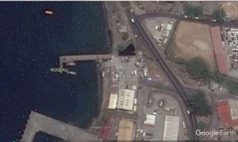
2 4. Map of tide gauge network in Dominica Figure 1. Google Map showing locations of stations Roseau Tide Gauge


3 Pre Hurricane Maria Post Hurricane Maria

4 Roseau Pier Post Hurricane Maria

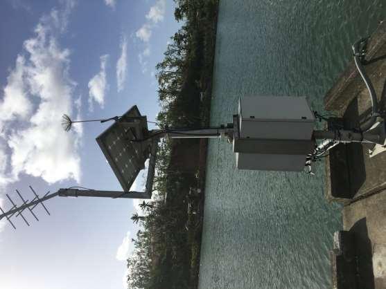
5 Marigot Tide Gauge
6

7 Marigot gauge post Hurricane Maria showing damage to mast

8 Portsmouth Tide Gauge

9 Portsmouth gauge with bench mark pre Hurricane Maria

10 Portsmouth gauge post Hurricane Maria
11 5. Tide gauge station(s) Name: Roseau GOES PID/Station Code: CA ROSE Lat Long Date Installed May 2011 Status Operator: Destroyed during Hurricane Maria University of Hawaii Sea Level Center (USA) Name: Portsmouth GOES PID Station Code: D PTMD Lat Long Date Installed July 2017 Status Destroyed during Hurricane Maria Operator: Dominica Meteorological Service Name: Marigot GOES PID D6700DEA Station Code: MRIG Lat Long Date Installed July 2017 Status Slightly damaged but Operational Operator: Dominica Meteorological Service 6. An overview of the gauge technology employed in the Stations: Name: Communications GOES PID Roseau GTS message CA
12 WMO Header GOES Channel Transmit Period Sampling Rate GLOSS Station ID DCP GPS (timing) GPS (high precision for positioning) Sensor #1 Sensor #2 Sensor #3 Met Sensors SEPO40 5 minutes Pressure transducer 1 minute Radar 1 minute Bubbler 5 min 5 minutes Pressure Radar Bubbler Name: Communications GOES PID WMO Header GOES Channel Transmit Period Sampling Rate GLOSS Station ID DCP GPS (timing) GPS (high precision for positioning) Sensor #1 Sensor #2 Sensor #3 Met Sensors Portsmouth Dominica GTS message D SODO10 5 minutes Pressure 10 minute Radar 10 minute Pressure Radar Water Temperature and Salinity (available of Port log Website) Name: Communications GOES PID WMO Header Marigot GTS message D67000DEA SODO10
 7.")
13 GOES Channel Transmit Period Sampling Rate GLOSS Station ID DCP GPS (timing) GPS (high precision for positioning) Sensor #1 Sensor #2 Sensor #3 Met Sensors 5 minutes Radar 1 minute Radar 1 minute Pressure Transducer 5 min Radar Pressure transducer Water Temperature and Salinity (available of Port log Website) 7. Bench Marking and Leveling: Portsmouth and Marigot Tide gauge Station: - 5 Benchmarks were installed and levelled in late August 2017 Bench Mark layout at Roseau site


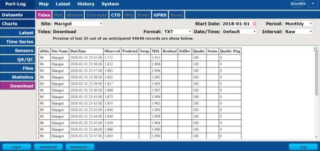
14 8. An overview of the data availability: The data of Marigot Station is available on the website:
15
16 9. Web, etc. addresses of data banks and of sources of further information National Disaster Coordinator - Mr. Fitzroy Pascal Office of Disaster Management Jimmit, Dominica Tel: (767) ; Mob:(767) Dominica Meteorological Service Tel: (767) ; Fax: (767) Senior Meteorological Officer - Mr. Marshall Alexander Mob: (767) Instrument Technicians - Mrs. Janelle Garraway-McPherson / Mrs. Farrah Rocque-Carriere Mob: (767) ; / (767) Lands and Surveys Division - Surveyor Mr. Vivian Eugene Mob: (767) PPCR/DVRP Project Coordination Unit (Pilot Programme on Climate Resilience/Disaster Vulnerability Reduction Project) Project Coordinator - Mr. Colin Guiste and/or Environmental Specialist - Mrs Andrea Marie 38 Cork Street, Roseau Commonwealth of Dominica Tel: (767) / (767) Future Plans. National Oceanography Centre (UK) - (ETA March 2018) - Repair/upgrade the Marigot Station GPS functionality to collect GNSS data. - Replacement of the Portsmouth Tide gauge at a new location University of Hawaii - (ETA July 2018) - Replacement of the Roseau Tide gauge Station
17 SAMPLE DATA - ONLINE TIDE TABLE AND TASK TIDE PREDICTION DATE DMS TASK 1/1/2018 3:15 3:30 1/1/2018 8:06 7:48 1/1/ :27 14:25 1/1/ :39 21:53 2/1/2018 4:02 4:23 2/1/2018 8:56 8:30 2/1/ :18 15:21 2/1/ :28 22:39 3/1/2018 4:47 5:34 3/1/2018 9:47 9:41 3/1/ :10 16:08 3/1/ :16 23:26 4/1/2018 5:32 6:30 4/1/ :41 11:00 4/1/ :02 16:52 5/1/2018 0:04 0:12 5/1/2018 6:18 7:21 5/1/ :40 11:52 5/1/ :56 17:39 6/1/2018 0:51 0:54 6/1/2018 7:05 8:03 6/1/ :44 12:46 6/1/ :54 18:37 7/1/2018 1:39 1:34 7/1/2018 7:55 8:31 7/1/ :57 13:53 7/1/ :58 19:47 8/1/2018 2:28 2:20 8/1/2018 8:48 9:07 8/1/ :16 15:06 8/1/ :14 20:54 9/1/2018 3:19 3:10 9/1/2018 9:44 10:00 9/1/ :35 16:12 9/1/ :40 22:48 10/1/2018 4:11 4:02 10/1/ :39 11:00 10/1/ :45 17:49 11/1/2018 0:00 0:06 11/1/2018 5:03 4:50 11/1/ :30 11:54 11/1/ :44 18:56 DATE DMS TASK 12/1/2018 1:03 2:42 12/1/2018 5:52 5:37 12/1/ :17 12:41 12/1/ :33 19:45 13/01/2018 1:50 3:48 13/01/2018 6:38 6:30 13/01/ :59 13:24 13/01/ :15 20:28 14/01/2018 2:29 4:36 14/01/2018 7:21 7:42 14/01/ :38 14:05 14/01/ :53 21:08 15/01/2018 3:02 5:15 15/01/2018 8:00 8:37 15/01/ :15 14:42 15/01/ :28 21:50 16/01/2018 3:33 5:51 16/01/2018 8:38 9:23 16/01/ :52 15:13 16/01/ :02 22:31 17/01/2018 4:05 6:23 17/01/2018 9:14 10:03 17/01/ :28 15:39 17/01/ :34 23:11 18/01/2018 4:38 6:51 18/01/2018 9:51 10:38 18/01/ :05 16:09 18/01/ :06 23:46 19/01/2018 5:12 7:11 19/01/ :30 11:18 19/01/ :43 16:51 19/01/ :38 0:21 20/01/2018 5:47 7:21 20/01/ :13 12:08 20/01/ :23 17:42 DATE DMS TASK 22/01/2018 7:00 7:45 22/01/ :58 14:01 22/01/ :59 19:36 23/01/2018 1:26 2:16 23/01/2018 7:40 8:06 23/01/ :04 14:52 23/01/ :04 20:27 24/01/2018 2:11 2:44 24/01/2018 8:26 8:36 24/01/ :19 15:41 24/01/ :26 21:16 25/01/2018 3:03 2:09 25/01/2018 9:20 9:14 25/01/ :36 16:31 25/01/ :59 22:06 26/01/2018 4:01 2:47 26/01/ :22 9:58 26/01/ :47 17:29 27/01/2018 0:21 0:40 27/01/2018 5:02 3:31 27/01/ :27 10:46 27/01/ :51 19:27 28/01/2018 1:24 1:27 28/01/2018 6:02 4:18 28/01/ :30 11:39 28/01/ :47 20:04 29/01/2018 2:16 2:09 29/01/2018 7:00 6:27 29/01/ :28 12:42 29/01/ :38 20:45 30/01/2018 3:01 2:50 30/01/2018 7:55 7:19 30/01/ :23 14:11 30/01/ :25 21:29 31/01/2018 3:42 3:35 31/01/2018 8:48 8:22 31/01/ :15 15:02 31/01/ :10 22:15 21/01/2018 0:11 0:59 21/01/2018 6:23 7:30 21/01/ :01 13:05 21/01/ :08 18:39
18 Acknowledgement & Credit: National Oceanographic Centre; University of Hawaii; IOC Sea Level Monitoring Facility; UNESCO
Charles Magori. Status Report of GLOSS Tide Gauges in Kenya
 GLOSS Group of Experts Meeting February 2005 Charles Magori Introduction Status Report of GLOSS Tide Gauges in Kenya There is growing concern about the rise in mean sea level around the globe. To address
SOUTH AFRICAN NAVY HYDROGRAPHIC OFFICE
 SOUTH AFRICAN NAVY HYDROGRAPHIC OFFICE GLOSS National Report for South Africa 2011 Compiled by Ms Ruth Farre Superintendent Tidal Information 1. Introduction The South African coastline is approximately
Sea Level Monitoring and the GLOSS Programme
 Sea Level Monitoring and the GLOSS Programme Philip L. Woodworth Permanent Service for Mean Sea Level Proudman Oceanographic Laboratory, UK Port Meteorological Officers Meeting, IMO, 25 July 2003 www.pol.ac.uk
FOURTH INTERNATIONAL PORT METEOROLOGICAL OFFICERS WORKSHOP AND SUPPORT TO GLOBAL OCEAN OBSERVATIONS USING SHIP LOGISTICS
 FOURTH INTERNATIONAL PORT METEOROLOGICAL OFFICERS WORKSHOP AND SUPPORT TO GLOBAL OCEAN OBSERVATIONS USING SHIP LOGISTICS PMO-IV 8-10 DEC 2010, ORLANDO, FLORIDA, USA 1 This presentation is generally for
Tsunami detection component: discussion about the existing network and real-time data processing. Begoña Pérez Gómez, Puertos del Estado, Spain
 Tsunami detection component: discussion about the existing network and real-time data processing Begoña Pérez Gómez, Puertos del Estado, Spain Outline Marine network: role within TWS s NEAMTWS overview
REPORT ON SEA LEVEL MEASUREMENT FOR GHANA
 20TH SEPTEMBER 2006 REPORT ON SEA LEVEL MEASUREMENT FOR GHANA Emmanuel K. Nkebi 1 1 Survey Department of Ghana, P. O. Box CT903, Accra Tel: 233 21 777 334 Fax : 233 21 765687 E-mail: survey@ghana.com E-mail:eknkebi@yahoo.com
Marshall Alexander Forecaster Commonwealth of Dominica
 Marshall Alexander Forecaster Commonwealth of Dominica Dominica 2015 Impacts Tropical Storm Danny (August 24 th ) Tropical Storm Erika (August 27 th ) Tropical Storm Grace (Remnants) (September 10 th -11
SEA LEVEL MEASUREMENT AND ANALYSIS IN THE WESTERN INDIAN OCEAN
 INTERGOVERNMENTAL OCEANOGRAPHIC COMMISSION (of UNESCO) SEA LEVEL MEASUREMENT AND ANALYSIS IN THE WESTERN INDIAN OCEAN NATIONAL REPORTS MAURITIUS Sachooda Ragoonaden and B. Dunputh Meteorological Services
The Impact of 2007 Atlantic Hurricane Season on Dominica
 The Impact of 2007 Atlantic Hurricane Season on Dominica DOMINICA November 2007 Main Activities Freak Twister on June 21st 2007. Hurricane Dean on August 16th to 17th 2007 Active Tropical Wave on September
Strategic Planning of Tuvalu Meteorological Service
 WMO Regional Seminar on Enhancing Service Delivery by National Meteorological & Hydrological Services (NMHSs( NMHSs) ) in RA V Kuala Lumpur, Malaysia, 2 6 April 2007 Strategic Planning of Tuvalu Meteorological
The current status, functions, challenges and needs of South Sudan Meteorological Department (SSMD)
") The current status, functions, challenges and needs of South Sudan Meteorological Department (SSMD) Presented: by Mojwok Ogawi Modo, South Sudan Meteorological Department. Background The present SSMD was
The current status, functions, challenges and needs of South Sudan Meteorological Department (SSMD) Presented: by Mojwok Ogawi Modo, South Sudan Meteorological Department. Background The present SSMD was
The Global Sea Level Observing System (GLOSS) Andrew Willmott
 Andrew Willmott") The Global Sea Level Observing System (GLOSS) Andrew Willmott A Big Scientific Issue Sea Level Rise The rate of global mean sea level rise increased between the 19 th and 20 th century MSL rose by 1-2
The Global Sea Level Observing System (GLOSS) Andrew Willmott A Big Scientific Issue Sea Level Rise The rate of global mean sea level rise increased between the 19 th and 20 th century MSL rose by 1-2
JCOMM Overview. Val Swail Environment and Climate Change Canada JCOMM representative to IOGP Metocean Committee
 JCOMM Overview Val Swail Environment and Climate Change Canada JCOMM representative to IOGP Metocean Committee IOGP/JCOMM/WCRP Workshop Our Future Climate Understanding the spread of physical risk for
CLIMATE CHANGE ADAPTATION BY MEANS OF PUBLIC PRIVATE PARTNERSHIP TO ESTABLISH EARLY WARNING SYSTEM
 CLIMATE CHANGE ADAPTATION BY MEANS OF PUBLIC PRIVATE PARTNERSHIP TO ESTABLISH EARLY WARNING SYSTEM By: Dr Mamadou Lamine BAH, National Director Direction Nationale de la Meteorologie (DNM), Guinea President,
Integrating Hydrologic and Storm Surge Models for Improved Flood Warning
 Integ Hydrologic and Storm Surge Models for Improved Flood Warning Leahy, C.P, Entel, M, Sooriyakumaran, S, and Warren, G Flood Warning Program Office, Bureau of Meteorology, Docklands, Victoria National
(Country Report) [1]
![(Country Report) [1]](/thumbs/95/124397460.jpg "(Country Report) [1]") (Country Report) [1] VANUATU METEOROLOGY AND GEO-HAZARDS DEPARTENT Private Mail Bag 9054 Port Vila Vanuatu (678) 24686 Email: admin@meteo.gov.vu, forecast@meteo.gov.vu Jerry Natugogona (Senior Forecaster)
(Country Report) [1] VANUATU METEOROLOGY AND GEO-HAZARDS DEPARTENT Private Mail Bag 9054 Port Vila Vanuatu (678) 24686 Email: admin@meteo.gov.vu, forecast@meteo.gov.vu Jerry Natugogona (Senior Forecaster)
Quality assurance for sensors at the Deutscher Wetterdienst (DWD)
") Quality assurance for sensors at the Deutscher Wetterdienst (DWD) Quality assurance / maintenance / calibration Holger Dörschel, Dr Tilman Holfelder WMO International Conference on Automatic Weather Stations
Quality assurance for sensors at the Deutscher Wetterdienst (DWD) Quality assurance / maintenance / calibration Holger Dörschel, Dr Tilman Holfelder WMO International Conference on Automatic Weather Stations
DBCP National Report Germany. 28 th DBCP Fremantle, 6 st of October 2012 Kai Herklotz (BSH)
") DBCP National Report Germany 28 th DBCP Fremantle, 6 st of October 2012 Kai Herklotz (BSH) Outline BSH and its relation to the DBCP ARGO-Program Other activities MARNET Perspectives 06.10.2012 28th DBCP,
DBCP National Report Germany 28 th DBCP Fremantle, 6 st of October 2012 Kai Herklotz (BSH) Outline BSH and its relation to the DBCP ARGO-Program Other activities MARNET Perspectives 06.10.2012 28th DBCP,
Copernicus Overview. Major Emergency Management Conference Athlone 2017
 Copernicus Overview Major Emergency Management Conference Athlone 2017 Copernicus is a European programme implemented by the European Commission. The services address six thematic areas: land, marine,
R E P U B L I C O F C Y P R U S. NATIONAL REPORT OF CYPRUS TO THE 19 th MEDITERRANEAN AND BLACK SEAS HYDROGRAPHIC COMMISSION (MBSHC)
") R E P U B L I C O F C Y P R U S NATIONAL REPORT OF CYPRUS TO THE 19 th MEDITERRANEAN AND BLACK SEAS HYDROGRAPHIC COMMISSION (MBSHC) BATUMI MEETING 30 JUNE TO 02 JULY 2015 NATIONAL REPORT OF CYPRUS TO THE
R E P U B L I C O F C Y P R U S NATIONAL REPORT OF CYPRUS TO THE 19 th MEDITERRANEAN AND BLACK SEAS HYDROGRAPHIC COMMISSION (MBSHC) BATUMI MEETING 30 JUNE TO 02 JULY 2015 NATIONAL REPORT OF CYPRUS TO THE
Reykjavik, 28 th Jan Dr. Eamon McKeogh Igor Kerin
 GNSS meteorology - Ireland National report 3rd ES1206 Workshop GNSS4SWEC - Advanced Global Navigation Satellite Systems tropospheric products for monitoring severe weather events and climate Reykjavik,
Sea Level Variability in the East Coast of Male, Maldives
 Sea Level Variability in the East Coast of Male, Maldives K.W. Indika 1 *, E.M.S. Wijerathne 2, G. W. A. R. Fernando 3, S.S.L.Hettiarachchi 4 1 National Aquatics Resources Research and Development Agency,
RONMAC Monitoring Station Report Report Date: August 14 th, 2001
 RONMAC Monitoring Station Report Report Date: August 14 th, 2001 Station Number: 96629571 Station Name: Puerto Corinto, Nicaragua Station Location: 12 0 28.7'N/87 0 10.1'W Time Meridian: 90W Original Installation
Wind Tower Deployments and Pressure Sensor Installation on Coastal Houses Preliminary Data Summary _ Sea Grant Project No.
 Wind Tower Deployments and Pressure Sensor Installation on Coastal Houses Preliminary Data Summary _ Sea Grant Project No.:1020040317 Submitted to: South Carolina Sea Grant Consortium 287 Meeting Street
Red de Observacion del Nivel del Mar para America Central (RONMAC)
") Red de Observacion del Nivel del Mar para America Central (RONMAC) Guatemala Reconnaissance Report Monday, June 19, 2000 Began with a meeting at Instituto Nacional de Sismologia Vulcanologia Meteorologia
Red de Observacion del Nivel del Mar para America Central (RONMAC) Guatemala Reconnaissance Report Monday, June 19, 2000 Began with a meeting at Instituto Nacional de Sismologia Vulcanologia Meteorologia
Experiences on Data and Observational Requirements in the Caribbean
 Experiences on Data and Observational Requirements in the Caribbean UNFCCC Expert Workshop on Methods & Tools and on Data & Observations under the NWP on Impacts, Vulnerability & Adaptation to Climate
Weather Forecasting in Flood Forecasting Activities
 Weather Forecasting in Flood Forecasting Activities Eugene Poolman South African Weather Service Representing CBS Pretoria South Africa FCAST PRES 20130919 001 Main Activities of CBS Development, implementation
Operational Applications of Awos Network in Turkey
 Operational Applications of Awos Network in Turkey by Soner Karatas Turkish State Meteorological Service Electronic Observing Systems Division Kütükcü Alibey Cad. No:4 06120 Kalaba-Ankara-TURKEY Tel:+90-312-302
networks from ISPRA GABRIELE NARDONE, MAURO BENCIVENGA, GIOVANNI ARENA
 The Italian observational networks from ISPRA retemareografica@isprambiente.itit reteondametrica@isprambiente.it GABRIELE NARDONE, MAURO BENCIVENGA, GIOVANNI ARENA ISPRA - RMN Italian Tide Gauge Network
THE OPEN UNIVERSITY OF SRI LANKA
 THE OPEN UNIVERSITY OF SRI LANKA Extended Abstracts Open University Research Sessions (OURS 2017) 16 th & 17 th November, 2017 The Open University of Sri Lanka - 2017 All rights reserved. No part of this
Recent development of the National Hydro-Meteorological Service (NHMS) of Viet Nam for disaster risk reduction
 of Viet Nam for disaster risk reduction") Ministry of Natural Resources and Environment National Hydro-Meteorological Service Recent development of the National Hydro-Meteorological Service (NHMS) of Viet Nam for disaster risk reduction Tran Van
Ministry of Natural Resources and Environment National Hydro-Meteorological Service Recent development of the National Hydro-Meteorological Service (NHMS) of Viet Nam for disaster risk reduction Tran Van
Indian Ocean Tsunami Warning System: Example from the 12 th September 2007 Tsunami
 Indian Ocean Tsunami Warning System: Example from the 12 th September 2007 Tsunami Charitha Pattiaratchi 1 Professor of Coastal Oceanography, The University of Western Australia Email: chari.pattiaratchi@uwa.edu.au
RCOF Review [Regional Climate Outlook Forum for the Gulf of Guinea region of Africa - PRESAGG] Status Report
![RCOF Review [Regional Climate Outlook Forum for the Gulf of Guinea region of Africa - PRESAGG] Status Report](/thumbs/78/77466191.jpg "RCOF Review [Regional Climate Outlook Forum for the Gulf of Guinea region of Africa - PRESAGG] Status Report") RCOF Review 2017 [Regional Climate Outlook Forum for the Gulf of Guinea region of Africa - PRESAGG] Status Report Specific Climate features of concerned region This region typically covers the area below
RCOF Review 2017 [Regional Climate Outlook Forum for the Gulf of Guinea region of Africa - PRESAGG] Status Report Specific Climate features of concerned region This region typically covers the area below
Mediterranean Sea Level Changes over the Period
 Mediterranean Sea Level Changes over the Period 1961-2 Boris SHIRMAN and Yossi MELZER, Israel Key words: Sea level monitoring, Tide gauge operation, Tide gauge Bench Marks. ABSTRACT The mean value of the
Strategic Framework on Geospatial Information and Services for Disasters Relevance for the Americas Region
 Strategic Framework on Geospatial Information and Services for Disasters Relevance for the Americas Region Seventh Session of the Committee of Experts on UN-GGIM Side Event --- UN Headquarters, New York
Vision: The National Oceanography Centre will, by 2015, be recognised as the world-leading Centre for integrated ocean sciences and technology".
 National Oceanography Centre from coast to deep ocean Waterfront Campus, Southampton Vision: Joseph Proudman Building, Liverpool The National Oceanography Centre will, by 2015, be recognised as the world-leading
AHEAD OF THE STORM: Extreme Weather Resilience in the City of Toronto
 AHEAD OF THE STORM: Extreme Weather Resilience in the City of Toronto David MacLeod Toronto Environment and Energy Office Environmental Applied Science and Management Symposium 2013 March 21, 2013 Ahead
Jay Lawrimore NOAA National Climatic Data Center 9 October 2013
 Jay Lawrimore NOAA National Climatic Data Center 9 October 2013 Daily data GHCN-Daily as the GSN Archive Monthly data GHCN-Monthly and CLIMAT messages International Surface Temperature Initiative Global
State of Israel Ministry of Housing and Construction Survey of Israel. The Hydrological project case
 State of Israel Ministry of Housing and Construction Survey of Israel The Hydrological project case Survey of Israel Content Introduction To the Survey of Israel The operation assumptions The main responsibilities
Guidelines for sea level data transmissions through GTS in the frame of coastal hazard warning systems.
 Guidelines for sea level data transmissions through GTS in the frame of coastal hazard warning systems. V 1.1, February 2015 Editor: Noé Poffa, SHOM Measuring and Instrumentation department Reviewer: Guillaume
RONMAC Monitoring Station Report Report Date: August 7 th, 2001
 RONMAC Monitoring Station Report Report Date: August 7 th, 2001 Station Number: 96489581 Station Name: Puerto Acajutla, El Salvador Station Location: 13 0 34.42 N 89 0 50.31 W Time Meridian: 90W Original
Climate Change Impacts and Adaptation for Coastal Transport Infrastructure in Caribbean SIDS
 UNCTAD National Workshop Saint Lucia 24 26 May 2017, Rodney Bay, Saint Lucia Climate Change Impacts and Adaptation for Coastal Transport Infrastructure in Caribbean SIDS Applying the thresholds method/approach
Flash flood forecasting and warning infrastructures of National Meteorology and Hydrological Services of Cambodia
 Development and Implementation of the South East Asia Flash Flood Guidance System (SEAFFGS) Ha Noi, Viet Nam, 20-23 November 2017 Flash flood forecasting and warning infrastructures of National Meteorology
SCIENCE OF TSUNAMI HAZARDS
 SCIENCE OF TSUNAMI HAZARDS ISSN 8755-6839 Journal of Tsunami Society International Volume 32 Number 1 2013 THE FRENCH TSUNAMI WARNING CENTER FOR THE MEDITERRANEAN AND NORTHEAST ATLANTIC: CENALT P. Roudil,
NOVALYNX CORPORATION ELEVATION CORRECTION TABLES FOR BAROMETRIC PRESSURE SENSORS
 NOVALYNX CORPORATION ELEVATION CORRECTION TABLES FOR BAROMETRIC PRESSURE SENSORS NovaLynx Corporation 431 Crown Point Cir Ste 120 Grass Valley, CA 95945-9531 USA Phone: (530) 823-7185 Fax: (530) 823-8997
Progress towards Establishment of a Unique Vertical Datum for Hydrography and Land Surveying in the Emirate of Dubai-Case Study
 Progress towards Establishment of a Unique Vertical Datum for Hydrography and Land Surveying in the Emirate of Dubai-Case Study Yousuf AL MARSOOQI, Amira ALZAROUNI, Satheesh GOPI, United Arab Emirates
Coastal Inundation Forecasting Demonstration Project CIFDP. Flood Forecasting Initiative-Advisory Group (FFI-AG 3), Geneva, 5-7 Dec, 2017
, Geneva, 5-7 Dec, 2017") Coastal Inundation Forecasting Demonstration Project CIFDP Flood Forecasting Initiative-Advisory Group (FFI-AG 3), Geneva, 5-7 Dec, 2017 Coastal Flooding & Vulnerable Populations Coastal populations are
Coastal Inundation Forecasting Demonstration Project CIFDP Flood Forecasting Initiative-Advisory Group (FFI-AG 3), Geneva, 5-7 Dec, 2017 Coastal Flooding & Vulnerable Populations Coastal populations are
Improving global coastal inundation forecasting WMO Panel, UR2014, London, 2 July 2014
 Improving global coastal inundation forecasting WMO Panel, UR2014, London, 2 July 2014 Cyclone Sidr, November 2007 Hurricane Katrina, 2005 Prof. Kevin Horsburgh Head of marine physics, UK National Oceanography
Joint Meeting of RA II WIGOS Project and RA V TT-SU on 11 October 2018 BMKG Headquarter Jakarta, Indonesia. Mrs. Sinthaly CHANTHANA
 Joint Meeting of RA II WIGOS Project and RA V TT-SU on 11 October 2018 BMKG Headquarter Jakarta, Indonesia Mrs. Sinthaly CHANTHANA Lao PDR Background Department of Meteorology and Hydrology ( DMH ) in
Innovative New Canister-type Auto Balloon Launcher aiming for Uninterrupted Observations Kensaku Shimizu, Ryota Maeda, and Norio Nagahama
 P2 (63) Innovative New Canister-type Auto Balloon Launcher aiming for Uninterrupted Observations Kensaku Shimizu, Ryota Maeda, and Norio Nagahama Meisei s new auto balloon launcher is designed to use multiple
MADIS Airlines for America Briefing
 MADIS Airlines for America Briefing Meteorological Assimilated Data Ingest System (MADIS) FPAW Briefing Steve Pritchett NWS Aircraft Based Observations Program Manager MADIS Defined MADIS is a meteorological
SUMMARY. Executive Summary: NAVAREA VIII provides the paper of MSI Self Assessment for CPRNW 10
 CPRNW Meeting 10 Agenda Item 3.2.1 CPRNW10/3/2/VIII MSI Self Assessment - NAVAREA VIII Submitted by INDIA SUMMARY Executive Summary: NAVAREA VIII provides the paper of MSI Self Assessment for CPRNW 10
SAWS: Met-Ocean Data & Infrastructure in Support of Industry, Research & Public Good. South Africa-Norway Science Week, 2016
 SAWS: Met-Ocean Data & Infrastructure in Support of Industry, Research & Public Good South Africa-Norway Science Week, 2016 Marc de Vos, November 2016 South Africa: Context http://learn.mindset.co.za/sites/default/files/resourcelib/e
Presentation on RSMC Nadi-TCC Activities
 6 th TC RSMC Technical Coordination Meeting, Brisbane, Australia, 2 5 Nov 2009 Presentation on RSMC Nadi-TCC Activities R. Prasad Director RSMC Nadi-TCC NADI TROPICAL CYCLONE CENTRE RSMC NADI - TCC Approved
Marine Notice No. 13 of 2009
 Marine Notice No. 13 of 2009 NOTICE TO ALL SHIPOWNERS, FISHING VESSEL OWNERS, AGENTS, SHIPMASTERS, SHIP MANAGEMENT COMPANIES, SKIPPERS, FISHERMEN, YACHTSMEN AND SEAFARERS. HELP IMPROVE QUALITY OF WEATHER
TYPHOON HAIYAN. Known as typhoon Yolanda in the Philippines. Most powerful storm to make landfall in recorded history
 TYPHOON HAIYAN Known as typhoon Yolanda in the Philippines Most powerful storm to make landfall in recorded history Worst hit provinces: Leyte and Eastern Samar with a combined population of 2.3 M Experienced
(1) Verification Report: Johnson, C., (2010). Simandou Hills: Verification Study of high Resolution Modelling. Exeter: UK Meteorological Office.
 Verification Report: Johnson, C., (2010). Simandou Hills: Verification Study of high Resolution Modelling. Exeter: UK Meteorological Office.") 9B Model Validation As a subset of Phase 3 of the study additional validation of the United Kingdom Meteorological Office (UKMO) Unified Model (the model) was undertaken to test the applicability to the
9B Model Validation As a subset of Phase 3 of the study additional validation of the United Kingdom Meteorological Office (UKMO) Unified Model (the model) was undertaken to test the applicability to the
13 th EUMETSAT User Forum in Africa
 13 th EUMETSAT User Forum in Africa GMES & Africa implementation in Western Africa Dogbeda M.Y. Azumah Regional Marine Centre University of Ghana Pictures zone UG GMES Presentation Layout UG G Project
REPORT ON CHINA NEAR-GOOS Delayed Mode DataBase (CDMDB)
") Sixteenth Session of the IOC/WESTPAC Coordinating Committee for the North-East Asian Regional-Global Ocean Observing System (NEAR-GOOS-CC-XVI) REPORT ON CHINA NEAR-GOOS Delayed Mode DataBase (CDMDB) Yu
Sixteenth Session of the IOC/WESTPAC Coordinating Committee for the North-East Asian Regional-Global Ocean Observing System (NEAR-GOOS-CC-XVI) REPORT ON CHINA NEAR-GOOS Delayed Mode DataBase (CDMDB) Yu
Job Description. 1) To provide a range of meteorological services, including a forecaster consultancy service.
 To provide a range of meteorological services, including a forecaster consultancy service.") Job Description Job Title: Department: Division: Location: Grade: Responsible to: Trainee Meteorological Forecaster Department of Infrastructure Ports Division Isle of Man Airport Trainee Met Officer Senior
Job Description Job Title: Department: Division: Location: Grade: Responsible to: Trainee Meteorological Forecaster Department of Infrastructure Ports Division Isle of Man Airport Trainee Met Officer Senior
Deutscher Wetterdienst
 WakeNet3-Greenwake Workshop Wake Vortex & Wind Monitoring Sensors in all weather conditions DWD s new Remote Wind Sensing Equipment for an Integrated Terminal Weather System (ITWS) Frank Lehrnickel Project
JCOMM-CHy Coastal Inundation Forecasting Demonstration Project (CIFDP)
") WMO World Meteorological Organization Working together in weather, climate and water JCOMM-CHy Coastal Inundation Forecasting Demonstration Project (CIFDP) Coastal Flooding & Vulnerable Populations Coastal
WMO World Meteorological Organization Working together in weather, climate and water JCOMM-CHy Coastal Inundation Forecasting Demonstration Project (CIFDP) Coastal Flooding & Vulnerable Populations Coastal
Analysis of National Vertical Datum Using Tidal Gauge Bench Mark in KOREA
 Analysis of National Vertical Datum Using Tidal Gauge Bench Mark in KOREA Hasu YOON, YunSoo CHOI, Hungkyu LEE, MinChol ChANG, Yong HUH (Republic of KOREA) What s TBM? TBM(Tidal Bench Mark) means a national
WORLD METEOROLOGICAL ORGANIZATION. WMO Regional Training Centres (RTCs) Course Offerings for the year Location (City/Country) Term I:
 Course Offerings for the year Location (City/Country) Term I:") RTC/Component: PAGASA RTC, WORLD METEOROLOGICAL ORGANIZATION WMO Regional Training Centres (RTCs) Course Offerings for the year Course Title 1. Meteorologists Training Course Holder of Bachelor s degree
RTC/Component: PAGASA RTC, WORLD METEOROLOGICAL ORGANIZATION WMO Regional Training Centres (RTCs) Course Offerings for the year Course Title 1. Meteorologists Training Course Holder of Bachelor s degree
R E P U B L I C O F C Y P R U S NATIONAL REPORT OF CYPRUS TO THE MEDITERRANEAN AND BLACK SEAS HYDROGRAPHIC COMMISSION (MBSHC)
") R E P U B L I C O F C Y P R U S NATIONAL REPORT OF CYPRUS TO THE MEDITERRANEAN AND BLACK SEAS HYDROGRAPHIC COMMISSION (MBSHC) ISTANBUL MEETING 25-27 SEPTEMBER 2013 NATIONAL REPORT OF CYPRUS TO THE MEDITERRANEAN
R E P U B L I C O F C Y P R U S NATIONAL REPORT OF CYPRUS TO THE MEDITERRANEAN AND BLACK SEAS HYDROGRAPHIC COMMISSION (MBSHC) ISTANBUL MEETING 25-27 SEPTEMBER 2013 NATIONAL REPORT OF CYPRUS TO THE MEDITERRANEAN
Weather Observing and Forecasting and the Hurricane Warning System in the Caribbean
 T.W. Sutherland: Weather Observing and Forecasting and the Hurricane Warning System in the Caribbean 6 ISSN 1000 7924 The Journal of the Association of Professional Engineers of Trinidad and Tobago Vol.42,
The Tampa Bay Catastrophic Plan Presentation to CFGIS Users Group FDOT District 5 Urban Offices - Orlando July 30, 2010
 The Tampa Bay Catastrophic Plan Presentation to CFGIS Users Group FDOT District 5 Urban Offices - Orlando July 30, 2010 Brady Smith Senior Planner Tampa Bay Regional Planning Council Introduction Recent
EDUCATION PROGRAMS GUIDE
 EDUCATION PROGRAMS GUIDE Inner Space Center University of Rhode Island Graduate School of Oceanography innerspacecenter.org ABOUT THE ISC The Inner Space Center (ISC) is an international leader in ocean
COUNTRY PRESENTATION ON MR JAYNAL ABEDIN JOINT SECRETARY ( WORKS & DEVELOPMENT ) MINISTRY OF DEFENCE
 MINISTRY OF DEFENCE") COUNTRY PRESENTATION ON By MR JAYNAL ABEDIN JOINT SECRETARY ( WORKS & DEVELOPMENT ) MINISTRY OF DEFENCE Bangladesh Geographical Location of Bangladesh Bangladesh Country at a Glance Physical Features 1,230
COUNTRY PRESENTATION ON By MR JAYNAL ABEDIN JOINT SECRETARY ( WORKS & DEVELOPMENT ) MINISTRY OF DEFENCE Bangladesh Geographical Location of Bangladesh Bangladesh Country at a Glance Physical Features 1,230
PARTICIPATION IN THE WMO VOLUNTARY OBSERVING SHIPS (VOS) SCHEME
 SCHEME") INTERNATIONAL MARITIME ORGANIZATION 4 ALBERT EMBANKMENT LONDON SE1 7SR Telephone: 020 7735 7611 Fax: 020 7587 3210 IMO E Ref. T2-OSS/1.4 MSC.1/Circ.1293 10 December 2008 PARTICIPATION IN THE WMO VOLUNTARY
INTERNATIONAL MARITIME ORGANIZATION 4 ALBERT EMBANKMENT LONDON SE1 7SR Telephone: 020 7735 7611 Fax: 020 7587 3210 IMO E Ref. T2-OSS/1.4 MSC.1/Circ.1293 10 December 2008 PARTICIPATION IN THE WMO VOLUNTARY
UK Argo. AST#16, Brest, France, March Crown copyright Met Office
 UK Argo AST#16, Brest, France, March 2015 UK Argo the beginning The original commitment made by Government CSA in 1999 was that the UK would contribute to Argo to at least a GNP-level based share at full
EUMETSAT s Support to Climate Services and User Support. Joachim Saalmüller
 EUMETSAT s Support to Climate Services and User Support Joachim Saalmüller 1 User Forum in Africa September 2016 Outline of my talk EUMETSAT in support of climate services Exploring our data and subscribing
Underway Data Management via the SAMOS Initiative
 Underway Data Management via the SAMOS Initiative Shawn R. Smith 1, Jeremy Rolph 1, Kristen Briggs 1, Mark A. Bourassa 1,2, Daniel Wolfe 3, and Chris Fairall 4 1 COAPS, Florida State University, Tallahassee,
METEOROLOGICAL WARNINGS STUDY GROUP (METWSG)
") METWSG/4-SN No. 6 12/3/12 METEOROLOGICAL WARNINGS STUDY GROUP (METWSG) FOURTH MEETING Montréal, 15 to 18 May 2012 Agenda Item 6: Wind shear, turbulence and tsunami warnings TSUNAMI INFORMATION (Presented
METWSG/4-SN No. 6 12/3/12 METEOROLOGICAL WARNINGS STUDY GROUP (METWSG) FOURTH MEETING Montréal, 15 to 18 May 2012 Agenda Item 6: Wind shear, turbulence and tsunami warnings TSUNAMI INFORMATION (Presented
Be relevant and effective thinking beyond accuracy and timeliness
 The Fourth Technical Conference on the Management of Meteorological and Hydrological Services in WMO RA II (Asia) Be relevant and effective thinking beyond accuracy and timeliness C. Y. LAM Hong Kong Observatory
Enhancing The Delivery Of Weather & Climate Information To End-Users. by Meteorological Services Division, NEA, Singapore
 Enhancing The Delivery Of Weather & Climate Information To End-Users by Meteorological Services Division, NEA, Singapore WMO RA V Seminar on Enhancing Service Delivery Kuala Lumpur, Malaysia, 2-6 April
Steve Colwell. British Antarctic Survey
 Global Climate Observing System (GCOS) Steve Colwell British Antarctic Survey Goal and Structure of GCOS The Goal of GCOS is to provide continuous, reliable, comprehensive data and information on the state
TEMPLATE FOR NATIONAL REPORTS. National Reports will be posted to the ICG/CARIBE EWS-XII web site without TWFP contact details
 IOC Circular Letter, 2661-1 TEMPLATE FOR NATIONAL REPORTS National Reports will be posted to the ICG/CARIBE EWS-XII web site without TWFP contact details BASIC INFORMATION PRELIMINAR NATIONAL REPORT Submitted
Long Term Monitoring of the Mediterranean and Red Sea Levels in Israel
 Long Term Monitoring of the Mediterranean and Red Sea Levels in Israel Boris SHIRMAN and Yossi MELZER, Israel Key words: tide-gauge station, mean sea level, geoid, meteorological factors. SUMMARY The Survey
National Report on Weather Forecasting Service
 MINISTRY OF WATER RESOURCES AND METEOROLOGY DEPARTMENT OF METEOROLOGY, CAMBODIA National Report on Weather Forecasting Service Tokyo, 11-15 March 2014 Department of Meteorology, Cambodia Presentation Outline
Seismic and Tsunami Observations of Indonesia
 (Indonesia, Mr. Fatchurochman Iman, 2010-2011S, Mr. Dwi Hartanto/Mr. Tatok Yatimantoro, 2011-2012T) Seismic and Tsunami Observations of Indonesia 1. Seismic Monitoring Agency for Meteorology, Climatology
NWC-SAF Satellite Application Facility in Support to Nowcasting and Very Short Range Forecasting
 NWC-SAF Satellite Application Facility in Support to Nowcasting and Very Short Range Forecasting Marianne König Slide 1 Satellite Application Facilities (SAFs) in Europe Member State Cooperating State
TONGA COUNTRY REPORT. Officer : John Holi
 TONGA COUNTRY REPORT Officer : John Holi OUTLINES INTRODUCTION BACKGROUND INFORMATION CLIMATE TONGA METEOROLOGICAL SERVICE PROPOSAL INTRODUCTION Location of Tonga Lies between 15 173 W 155 177 W 25.55
GLOSS ACTIVYTY. List of the proposed Russian GLOSS- network Name/ GLOSSnumber observation
 4.06.2007 National report of Russia (GLOSS and Tsunami activity) Oleg I. Zilberstein, Russia, Moscow, 123242, Bolshoi Predtechenski per. 9-13, HydroMeteoCentre of Russia, -tel/fax+7(095) 2559307, email:
Storm surge forecasting and other Met Office ocean modelling
 Storm surge forecasting and other Met Office ocean modelling EMODnet stakeholder meeting Clare O Neill + many others Outline Ocean modelling at the Met Office Storm surge forecasting Current operational
1 Introduction. Station Type No. Synoptic/GTS 17 Principal 172 Ordinary 546 Precipitation
 Use of Automatic Weather Stations in Ethiopia Dula Shanko National Meteorological Agency(NMA), Addis Ababa, Ethiopia Phone: +251116639662, Mob +251911208024 Fax +251116625292, Email: Du_shanko@yahoo.com
Public Disclosure Copy
 Public Disclosure Authorized LATIN AMERICA AND CARIBBEAN Dominica Social, Urban, Rural and Resilience Global Practice Global Practice IBRD/IDA Investment Project Financing FY 2014 Seq No: 7 ARCHIVED on
Status of EUMETSAT Operational Services & EUMETCast Africa Dissemination Baseline Updates
 Status of EUMETSAT Operational Services & EUMETCast Africa Dissemination Baseline Updates Sally Wannop User Relations Manager 1 8th WMO RAIDEG meeting 1-2 November 2017 # 951881 Overview EUMETCast Overview
Inter-comparison of Raingauges on Rainfall Amount and Intensity Measurements in a Tropical Environment
 Inter-comparison of Raingauges on Rainfall Amount and Intensity Measurements in a Tropical Environment CHAN Ying-wa, Yu Choi-loi and TAM Kwong-hung Hong Kong Observatory 134A Nathan Road, Tsim Sha Tsui,
Australian National Report to DBCP. DBCP October, 2014 Weihai, China
 Australian National Report to DBCP DBCP-30 27-31 October, 2014 Weihai, China Outline Australian Bureau of Meteorology (ABOM) Drifting Buoys Background & Planning 2013/14 Deployments & Current Status 2014/15
Homework - Topographic Maps and What They Mean - Standard Earth Science
 Name: Mr. Schwartz Earth Science Period: Date: /10 Homework - Topographic Maps and What They Mean - Standard Earth Science Read pages 46-47 and 53-56 in your text. Then, answer the questions. Don t forget
National Report of New Zealand
 National Report of New Zealand Prepared for GLOSS Training Course Tokyo May 2006 Glen Rowe Data Analyst Hydrographic Services Land Information New Zealand National Office 160 Lambton Quay Wellington New
GREAT EXPERIENCE IN MONITORING SYSTEMS CAPACITY ON DEVELOPMENT AND CREATING SOLUTIONS ADVANCED ITALIAN TECHNOLOGY
 GREAT EXPERIENCE IN MONITORING SYSTEMS CAPACITY ON DEVELOPMENT AND CREATING SOLUTIONS ADVANCED ITALIAN TECHNOLOGY NESA Srl Via Sartori 6/8 31020 Vidor (TV) Italy www.nesasrl.it info@nesasrl.it Quality
London Heathrow Field Site Metadata
 London Heathrow Field Site Metadata Field Site Information Name: Heathrow src_id (Station ID number): 708 Geographic Area: Greater London Latitude (decimal ): 51.479 Longitude (decimal ): -0.449 OS Grid
"Outcomes of the storm surge and waves workshop in Dominican Republic and the questionnaire"
 "Outcomes of the storm surge and waves workshop in Dominican Republic and the questionnaire" Strengthening Regional Cooperation to Support Forecasting with Multi Hazard Approach in RA IV Ritz Carlton Grand
PAKISTAN NATIONAL REPORT
 PAKISTAN NATIONAL REPORT 16 th MEETING NORTH INDIAN OCEAN HYDROGRAPHIC COMMISSION (NIOHC) CHITTAGONG, BANGLADESH 14-16 MARCH 2016 BY PAKISTAN NAVY HYDROGRAPHIC DEPARTMENT HYDROGRAPHIC DEPARTMENT OF PAKISTAN
Inter-comparison of Raingauges in a Sub-tropical Environment
 Inter-comparison of Raingauges in a Sub-tropical Environment TAM Kwong-hung, CHAN Ying-wa, CHAN Pak-wai and SIN Kau-chuen Hong Kong Observatory 134A Nathan Road, Tsim Sha Tsui, Kowloon, Hong Kong, China
17-18 March First Floor Conference Room. Subregional Headquarters for the Caribbean, and UNESCO
 Expert Group Meeting Implementing Rio+20: Integrated Planning for Sustainable Coastal Area Management in the Caribbean Region 17-18 March 2014 First Floor Conference Room ECLAC Subregional Headquarters
THAILAND NATIONAL REPORT
 NIOHC18 TH National Report THAILAND NATIONAL REPORT 18 th NORTH INDIAN OCEAN HYDROGRAPHIC COMMISSION (NIOHC) CONFERENCE Goa, India 9 th 12 th April 2018-1 - CONTENTS 1. Hydrographic Office / Service 3
Determining and Monitoring Sea Level in the Caribbean using
 Determining and Monitoring Sea Level in the Caribbean using Satellite Altimetry Dexter DAVIS (UWI,Trinidad & Tobago), Michael SUTHERLAND (Canada), Sandesh JAGGAN & Demi SINGH (UWI, Trinidad & Tobago) Overview