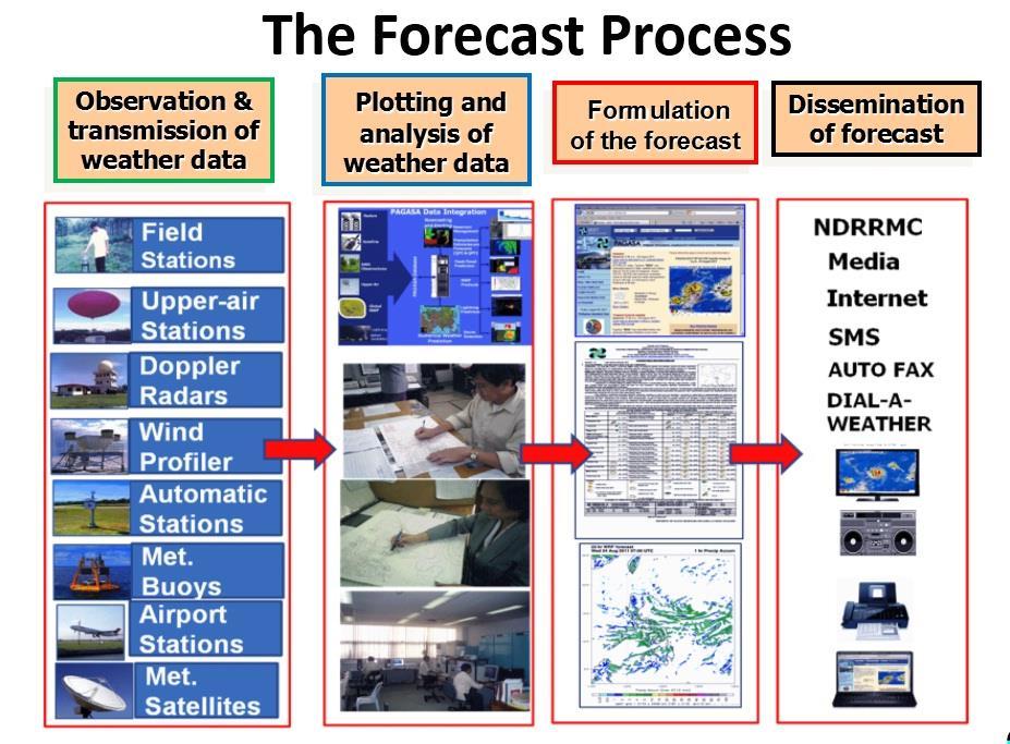
The Role of PAGASA in Disaster Mitigation
|
|
|
- Baldric Holt
- 6 years ago
- Views:
Transcription
1 The Role of PAGASA in Disaster Mitigation Christopher F. Perez 2017 ACTS Workshop on Extreme Weather Forecast and Water Resource Management Hanoi, Vietnam September 26-27, 2017


2
: Critical Analyses made Forecast 6hrly Actual hrly 12MN to 8AM 17 Jan closely observing/ monitoring the track of TS Amang 4-5 AM 17 Jan started to recurve Starting 8PM, Jan 16, TS")
3 Tropical Storm AMANG(Mekkhala), Jan st Tropical Cyclone in 2015, during Papal Visit in Tacloban Critical decision point (8PM Jan. 16 4AM Jan 17): Critical Analyses made Forecast 6hrly Actual hrly 12MN to 8AM 17 Jan closely observing/ monitoring the track of TS Amang 4-5 AM 17 Jan started to recurve Starting 8PM, Jan 16, TS Amang unexpectedly shifted directions from northwest to southwest raising the possibility of directly hitting Tacloban. At 3-4AM Jan17,we observed the slowing down of movement of Amang. At 4-5 am TS Amang started to recurve westward a significant development indicating it would follow a northwesterly track as earlier predicted by PAGASA.
4 Philippine Atmospheric, Geophysical and Astronomical Services Administration (PAGASA) Mission: Protecting lives, properties and livelihoods through timely, accurate and reliable weatherrelated information and services. as the National Meteorological and Hydrological Services (NMHS) of the Philippines shall be the authoritative voice in providing the warning against weather hazards for public safety.


 Field Stations National Capital Region Northern Luzon")
5 PAGASA ORGANIZATIONAL CHART OFFICE OF THE ADMINISTRATOR 3 Deputy Administrators Administration & Engineering Services Operations & Services Research & Development Administrative Division Financial, Planning and Management Division Engineering and Technical Services Division Weather Division Climatology and Agrometeorology Division Hydro-Meteorology Division Research & Development and Training Division Synoptic Observation Network Flood Forecasting Warning Centers Agromet Observation Network Radar Network Upper-Air Observation Network AWS Network Rainfall Station Network PAGASA Regional Services Divisions (5) Field Stations National Capital Region Northern Luzon Southern Luzon Visayas Mindanao
6
 every year, about 8 9 make")
7 An average of tropical cyclones enter /develop inside the Philippine Area of Responsibility (PAR) every year, about 8 9 make landfall.
8 Monthly Average Tropical Cyclone Occurrences within the PAR JAN FEB MAR APR MAY JUN JUL AUG SEP OCT NOV DEC

9 Consolidated tropical cyclone track within the PAR for the period

10
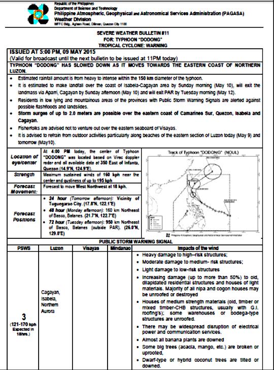
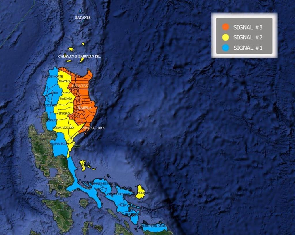
11 Tropical Cyclone Warning System Tropical Cyclone Warning Signals (TCWS) TCWS LEAD TIME * (hrs) WINDS (KPH) IMPACTS OF THE WIND # No damage to low risk structure to very light damage # Light to moderate damage # Moderate to heavy damage # Heavy to very heavy damage #5 12 more than 220 Very heavy to widespread damage

12


13 Mode of Dissemination PAGASA.DOST.GOV.PH
14 FOR ANY EARLY WARNING SYSTEM TO SUCCEED, SEVERAL COMPONENTS ARE NECESSARY: Technology to detect and monitor the hazard; Communication systems to alert the public; Local leaders trained to make the right decisions; A public that is educated to react appropriately to warnings; and Response protocols such as evacuation plans prepared and rehearsed well in advance of the threat.
15 All these elements must work well, both individually and in harmony. Failure in any one of these elements can mean failure of the whole early warning system.


16 MERANTI Strongest typhoon at landfall over any part of the Philippines in 2016 A REVISIT
 11/0000")


17 TRACK OF TYPHOON MERANTI (1718) 11/0000 UTC TO 14/0600 UTC Left PAR Last bulletin issued by PAGASA 14/0600 UTC Landfall over Itbayat island 13/1700 UTC Reached Peak Intensity 13/1200 UTC First bulletin issued by PAGASA 11/0000 UTC Entered PAR Became Typhoon 11/0600 UTC
18 LANDFALL Meranti underwent rapid intensification over the Philippine Sea before reaching Luzon strait RI T+12H ( +20 kt) RI T+24H ( +30 kt) RI T+36H ( +40 kt) RI T+48H ( +50 kt) RI definition based on Kaplan et al. (2010)

19 ITBAYAT Itbayat BASCO TAIDONG Doppler Weather Radar Loop Central Weather Bureau, Taiwan HENGCHUN CALAYAN APARRI 98232

20 ITBAYAT HENGCHUN CALAYAN APARRI BASCO PAGASA-DOST Aparri Doppler Weather Radar 13 September 2016, 1500 UTC to 1900 UTC

21 MICROBAROGRAM Itbayat Data rendered unusable beyond 13/1630 UTC Last usable data 13/ 1630 UTC: STN: hpa MSL: hpa 12 AM 6 AM 12 PM 6 PM
22 METEOGRAM BASCO Highest observed wind NNE, 40 m/s (1600 UTC) Lowest pressure: hpa (1630 UTC)
23 NOTE: Microbarograph data from Itbayat (98132) alone could have been used to determine actual (near-peak or peak) intensity of Typhoon Meranti in terms of mean sea level pressure since the eye passed over the island. However, last usable data was 30 minutes before landfall or when the center fix was around 10 km from the station. Inferring that the central pressure was around 920 hpa given the last usable data doesn t make sense since the barograph tracing suggests that the pressure was still rapidly dropping. Basco (98134) was able to capture the v-like feature on the microbarograph before it ceased transmitting data (the stations was able to observe pressure data before, during and after the passage of the core). However, the center fix was still at least 25 km from the station during the entire passage (to put into perspective, radius of maximum winds (RMW) was 22 km based on JTWC best track data).
24 QUESTION What was the actual intensity (near-peak or peak) of Typhoon Meranti in terms of MSLP based on ground observations from these 2 stations and from other stations in the periphery of the tropical cyclone? SOLUTION Use the typhoon pressure profile model H80 that best fits observation data from 0300 to 1800 UTC 13 September from 6 stations in Southern Taiwan Extreme Northern Luzon area. P r = P c + Pe RMW r P = P env P c (Holland 1980, Holland 2008) P env = P OCI + 2 (Courtney and Knaff 2009) B ASSUMPTION B parameter limited from 1.0 to 2.5 (Holland 1980) at 0.5 intervals. Possible values of central pressure range from 850 to 925 hpa at 5 hpa intervals. Meranti is assumed to have symmetric, circular pressure field during the period used. Environmental Pressure (Penv) = 1009 hpa and RMW = 22 km (JTWC best track data). Pressure profile did not change significantly from 0300 to 1800 UTC 13 September Pressure data from all 6 stations are reliable Given that Meranti was undergoing an eyewall replacement cycle, RMW still co-located in the inner eyewall.

25 Taidong N, E Hourly Satellite and Radar Fixes of Typhoon Meranti UTC 13 September Hengchun N, E Basco N, E Itbayat N, E Calayan N, E Aparri N, E 2 stations within the core 4 stations in the periphery
26 74 observation data from 0300 UTC to 1800 UTC Philippines: Hourly Taiwan: 3-Hourly MSLP Observations from Synoptic Stations in Southern Taiwan and Extreme Northern Luzon UTC 13 September
27
28 RMSE OF VARIOUS H80 PRESSURE MODELS (VARYING B PARAMETER AND CENTRAL PRESSURE) UTC 13 September
29 Possible H80 models: Model Equation P r = e 22 r P r = e 22 r P r = e 22 r P r = e 22 r P r = e 22 r P r = e 22 r RMSD (hpa)
30 Central Pressure: 895 to 900 hpa Environmental Pressure: 1009 hpa Radius of Maximum Winds: 22 km
31 FINDINGS Based on MSLP observation from 6 synoptic stations in Southern Taiwan and Extreme Northern Luzon, the H80 model that best describes the pressure profile of Typhoon Meranti near landfall (following aforementioned assumptions) suggests that the central pressure of Meranti falls between 895 and 900 hpa, possibly 899 hpa. This represents the near-peak or peak intensity of Meranti. To put the obtained value into perspective, JMA and JTWC puts the lowest central pressure of Meranti at 890 and 887 hpa, respectively However, it was also noted that H80 models using 895 to 900 hpa as central pressure and 1.0 as Holland B parameter yields lower MSLP over radial distances above 150 km when compared with observation data. Nevertheless, these models yielded the best pressure profile when compared against observation following the assumptions stated earlier.

32 SOME NOTES Mean wind and gust observations were not used in determining the landfall intensity of Typhoon Meranti due to doubts on the reliability of instrument readings under such wind exposure. Both Itbayat and Basco stations reported damaged wind sensors in the aftermath of the passage, which puts into question the reliability of observed wind while the stations were within the eyewall of the Typhoon. Perform similar analysis on other intense landfalling tropical cyclones during the 2016 season (i.e. Super Typhoon Haima / Lawin and Typhoon Nock-ten / Nina) in order to verify if Meranti was indeed the strongest tropical cyclone to make landfall in any part of the Philippines in Nevertheless, the findings on this report puts Meranti as one of the strongest to make landfall in 2016 and possibly since modern PAGASA records began in 1950s.
33 REFERENCES Courtney, J., and J.A. Knaff, 2009: Adapting the Knaff and Zehr Wind-Pressure Relationship for operational use in Tropical Cyclone Warning Centres. Australian Meteorological and Oceanographic Journal, 58:3, Holland, G.J., 1980: An Analytic Model of the Wind and Pressure Profiles in Hurricanes. Mon. Wea. Rev., 108, , Holland, G., 2008: A Revised Hurricane Pressure Wind Model. Mon. Wea. Rev., 136, , Kaplan, J., M. DeMaria, and J.A. Knaff, 2010: A Revised Tropical Cyclone Rapid Intensification Index for the Atlantic and Eastern North Pacific Basins. Wea. Forecasting, 25, , EXTERNAL DATASET Best Track Data for 2016 from Japan Meteorological Agency (JMA) and Joint Typhoon Warning Center (JTWC) Weather Radar Composite from Central Weather Bureau (CWB) Inset satellite images from Naval Research Laboratory (NRL)

34 Thank you for your attention.
Storm Surge Forecasting and Warning in the Philippines
 Storm Surge Forecasting and Warning in the Philippines 3 rd Masterclass on Disaster Mitigation APAN46 Asia Pacific Advanced Network Meeting 08 August 2018 Jehan Fe S. Panti PAGASA-DOST jspanti@pagasa.dost.gov.ph
An Application of Hydrometeorological Information
 An Application of Hydrometeorological Information Weather-proof Café: Hydro-meteorological information in managing weather risks 17 19 November 2012 National Taiwan University, Chinese Taipei Nikos Viktor
Development of Tropical Storm Falcon (Meari) over the Philippines
 over the Philippines") Development of Tropical Storm Falcon (Meari) over the Philippines June 20-27, 2011 At the end of June, 2011, the Philippines were struck again by Tropical storm Falcon (Meari). After gaining strength over
Development of Tropical Storm Falcon (Meari) over the Philippines June 20-27, 2011 At the end of June, 2011, the Philippines were struck again by Tropical storm Falcon (Meari). After gaining strength over
"STUDY ON THE VARIABILITY OF SOUTHWEST MONSOON RAINFALL AND TROPICAL CYCLONES FOR "
 "STUDY ON THE VARIABILITY OF SOUTHWEST MONSOON RAINFALL AND TROPICAL CYCLONES FOR 2001 2010" ESPERANZA O. CAYANAN, Ph.D. Chief, Climatology & Agrometeorology R & D Section Philippine Atmospheric Geophysical
Tropical Cyclone Warning System in the Philippines
 Republic of the Philippines Department of Science and Technology PHILIPPINE ATMOSPHERIC GEOPHYSICAL AND ASTRONOMICAL SERVICES ADMINISTRAION (PAGASA) Science Garden Compound, Agham Road, Diliman, Quezon
The Pressure s On: Increased. Introduction. By Jason Butke Edited by Meagan Phelan
 The Pressure s On: Increased Realism in Tropical Cyclone Wind Speeds through Attention to Environmental Pressure 01.2012 By Jason Butke Introduction Because the Earth has a tilted axis and rotates, the
Response and Lesson Learned from Typhoon YOLANDA (HAIYAN)
") 9 th NARBO IWRM Training Tagaytay City May 12-19, 2014 Response and Lesson Learned from Typhoon YOLANDA (HAIYAN) Rene B. Paciente Weather Division, PAGASA Philippines OUTLINE 1. Meteorological Informations
9 th NARBO IWRM Training Tagaytay City May 12-19, 2014 Response and Lesson Learned from Typhoon YOLANDA (HAIYAN) Rene B. Paciente Weather Division, PAGASA Philippines OUTLINE 1. Meteorological Informations
Current Details from the Joint Typhoon Warning Center
 Current Details from the Joint Warning Center COORDINATES: 19.6 north, 125.5 east (previous location: 17.9 north, 130.3 east) LOCATION: 737 kilometers (458 miles) southeast of Taipei, Taiwan MOVEMENT:
EDNA L. JUANILLO Philippines
 Typhoon GLEnDA [RAMMASUN] EDNA L. JUANILLO Philippines TY GLENDA (RAMMASUN) (July 13-17, 2014) OTHER RELATED INFO It formed as a Tropical Depression (TD) over the Caroline Islands, Pacific Ocean, moving
Typhoon Haima (Lawin) Report #3 20 October 2016, 9.00AM PHT. Manila Observatory
 Report #3 20 October 2016, 9.00AM PHT. Manila Observatory") Typhoon Haima (Lawin) Report #3 20 October 2016, 9.00AM PHT Manila Observatory SUMMARY PAGASA reports eye of Super Typhoon Haima (Bagyong Lawin) located at 18.4 N, 120.3 E (as of 7 AM Oct 20) with max
Typhoon Haima (Lawin) Report #3 20 October 2016, 9.00AM PHT Manila Observatory SUMMARY PAGASA reports eye of Super Typhoon Haima (Bagyong Lawin) located at 18.4 N, 120.3 E (as of 7 AM Oct 20) with max
Typhoon Haima (Lawin) Report #4 20 October 2016, 3.00PM PHT. Manila Observatory
 Report #4 20 October 2016, 3.00PM PHT. Manila Observatory") Typhoon Haima (Lawin) Report #4 20 October 2016, 3.00PM PHT Manila Observatory SUMMARY PAGASA reports eye of Super Typhoon Haima (Bagyong Lawin) located at 18.5 N, 119.7 E (as of 10 AM Oct 20) with max
Typhoon Haima (Lawin) Report #4 20 October 2016, 3.00PM PHT Manila Observatory SUMMARY PAGASA reports eye of Super Typhoon Haima (Bagyong Lawin) located at 18.5 N, 119.7 E (as of 10 AM Oct 20) with max
SUMMARY OF THE 2011 TYPHOON SEASON
 ECONOMIC AND SOCIAL COMMISSION FOR ASIA AND THE PACIFIC AND WORLD METEOROLOGICAL ORGANIZATION WRD/TC.44/4.1 Add. 2 06 February 2012 Typhoon Committee Forty Fourth Session 06 to 12 February 2012 Hangzhou,
Features of the wind fields associated with Typhoon 0418 (Songda) compared with those of Typhoon 9119 (Mireille)
 compared with those of Typhoon 9119 (Mireille)") Features of the wind fields associated with Typhoon 0418 (Songda) compared with those of Typhoon 9119 (Mireille) by Fumiaki Fujibe 1, Naoko Kitabatake 2, Kotaro Bessho 2 and Shunsuke Hoshino 3 ABSTRACT
Features of the wind fields associated with Typhoon 0418 (Songda) compared with those of Typhoon 9119 (Mireille) by Fumiaki Fujibe 1, Naoko Kitabatake 2, Kotaro Bessho 2 and Shunsuke Hoshino 3 ABSTRACT
UPDATE OF REGIONAL WEATHER AND SMOKE HAZE November 2016
 UPDATE OF REGIONAL WEATHER AND SMOKE HAZE November 2016 1. Review of Regional Weather Conditions in November 2016 1.1 Southwest Monsoon conditions prevailed on most days in October 2016 and the winds were
Reduction of the Radius of Probability Circle. in Typhoon Track Forecast
 Reduction of the Radius of Probability Circle in Typhoon Track Forecast Nobutaka MANNOJI National Typhoon Center, Japan Meteorological Agency Abstract RSMC Tokyo - Typhoon Center of the Japan Meteorological
1. Introduction. 2. Verification of the 2010 forecasts. Research Brief 2011/ February 2011
 Research Brief 2011/01 Verification of Forecasts of Tropical Cyclone Activity over the Western North Pacific and Number of Tropical Cyclones Making Landfall in South China and the Korea and Japan region
A Climatology of the Extratropical Transition of Tropical Cyclones in the Western North Pacific
 A Climatology of the Extratropical Transition of Tropical Cyclones in the Western North Pacific Naoko KITABATAKE (Meteorological Research Institute / Japan Meteorological Agency) 1 Outline 1. Topic 1:
Community-Based Flood Early Warning System (CBFEWS)
") Community-Based Flood Early Warning System (CBFEWS) Prepared by: Eng r. Hilario G. Esperanza Eng r.. Socrates F. Paat,, Jr. Flood Forecasting Branch PAGASA Weather Bureau Department of Science and Technology
Community-Based Flood Early Warning System (CBFEWS) Prepared by: Eng r. Hilario G. Esperanza Eng r.. Socrates F. Paat,, Jr. Flood Forecasting Branch PAGASA Weather Bureau Department of Science and Technology
A Tropical Cyclone with a Very Large Eye
 JANUARY 1999 PICTURES OF THE MONTH 137 A Tropical Cyclone with a Very Large Eye MARK A. LANDER University of Guam, Mangilao, Guam 9 September 1997 and 2 March 1998 1. Introduction The well-defined eye
Satellite Data Utilization and Meteorological Hazard Prevention In the Philippines
 Joint Integrated Global Water Cycle Observing(IGWCO)/ Coordinated Enhanced Observing Period (CEOP) Workshop 28 Feb. 4 March 2005, Tokyo, Japan Satellite Data Utilization and Meteorological Hazard Prevention
Verification of the Seasonal Forecast for the 2005/06 Winter
 Verification of the Seasonal Forecast for the 2005/06 Winter Shingo Yamada Tokyo Climate Center Japan Meteorological Agency 2006/11/02 7 th Joint Meeting on EAWM Contents 1. Verification of the Seasonal
UPDATE OF REGIONAL WEATHER AND SMOKE HAZE (December 2017)
") UPDATE OF REGIONAL WEATHER AND SMOKE HAZE (December 2017) 1. Review of Regional Weather Conditions for November 2017 1.1 In November 2017, Southeast Asia experienced inter-monsoon conditions in the first
UPDATE OF REGIONAL WEATHER AND SMOKE HAZE (December 2017) 1. Review of Regional Weather Conditions for November 2017 1.1 In November 2017, Southeast Asia experienced inter-monsoon conditions in the first
Extreme Winds in the Western North Pacific. Søren Ott
 in the Western North Pacific Søren Ott Outline Tropical cyclones and wind turbines Modelling extreme winds Validation Conclusions Cat. 4 tropical cyclone IVAN 15 Sept 2004 at landfall near Luisiana, USA
Heavy Rain/Flooding September 8-10 Associated with Tropical Storm Etau
 Heavy Rain/Flooding September 8-10 Associated with Tropical Storm Etau Wx Files Vol.32 September 24, 2015 Tropical Storm Etau made landfall over the Chita Peninsula in Aichi just after 10:00 AM on September
WORLD METEOROLOGICAL ORGANIZATION. WMO Regional Training Centres (RTCs) Course Offerings for the year Location (City/Country) Term I:
 Course Offerings for the year Location (City/Country) Term I:") RTC/Component: PAGASA RTC, WORLD METEOROLOGICAL ORGANIZATION WMO Regional Training Centres (RTCs) Course Offerings for the year Course Title 1. Meteorologists Training Course Holder of Bachelor s degree
RTC/Component: PAGASA RTC, WORLD METEOROLOGICAL ORGANIZATION WMO Regional Training Centres (RTCs) Course Offerings for the year Course Title 1. Meteorologists Training Course Holder of Bachelor s degree
ARUBA CLIMATOLOGICAL SUMMARY 2017 PRECIPITATION
 ARUBA CLIMATOLOGICAL SUMMARY 2017 PRECIPITATION The total amount of rainfall recorded at Reina Beatrix International Airport for the year 2017 was 391.0 mm. This is 17.1 % below normal ( Figure 1 ). During
OVERVIEW OF IMPROVED USE OF RS INDICATORS AT INAM. Domingos Mosquito Patricio
 OVERVIEW OF IMPROVED USE OF RS INDICATORS AT INAM Domingos Mosquito Patricio domingos.mosquito@gmail.com Introduction to Mozambique /INAM Introduction to AGRICAB/SPIRITS Objectives Material & Methods Results
Government of Sultanate of Oman Public Authority of Civil Aviation Directorate General of Meteorology. National Report To
 Government of Sultanate of Oman Public Authority of Civil Aviation Directorate General of Meteorology National Report To Panel on Tropical Cyclones in the Bay of Bengal And Arabian Sea 43rd Session, India
CLIMATE SERVICES for the AGRICUTURAL SECTOR in the PHILIPPINES
 CLIMATE SERVICES for the AGRICUTURAL SECTOR in the PHILIPPINES EDNA L. JUANILLO Weather Services Chief, PAGASA Technical Conference on Future Challenges and Opportunities in Agricultural Meteorology 16-17
HURRICANE JEANNE CHARACTERISTICS and STORM TIDE EVALUATION
 HURRICANE JEANNE CHARACTERISTICS and STORM TIDE EVALUATION ((DRAFT)) By Robert Wang and Michael Manausa Sponsored by Florida Department of Environmental Protection, Bureau of Beaches and Coastal Systems
Introduction. Observed Local Trends. Temperature Rainfall Tropical Cyclones. Projections for the Philippines. Temperature Rainfall
 PAGASA-DOST ntroduction Observed Local Trends Temperature Rainfall Tropical Cyclones Projections for the Philippines Temperature Rainfall Climate Change ssue ncreased use of fossil fuel Global Warming
Current Details from the Joint Typhoon Warning Center
 Current Details from the Joint Warning Center COORDINATES: 10.2 north, 148.1 east (previous location: 10.1 north, 148.3 east) LOCATION: 520 kilometers (325 miles) southeast of Andersen Air Force Base,
MEMBER REPORT (Singapore)
") MEMBER REPORT (Singapore) ESCAP/WMO Typhoon Committee 12th Integrated Workshop Jeju, Republic of Korea 30 October 3 November 2017 CONTENTS I. Overview of tropical cyclones which have affected/impacted
MEMBER REPORT (Singapore) ESCAP/WMO Typhoon Committee 12th Integrated Workshop Jeju, Republic of Korea 30 October 3 November 2017 CONTENTS I. Overview of tropical cyclones which have affected/impacted
JCOMM-CHy Coastal Inundation Forecasting Demonstration Project (CIFDP)
") WMO World Meteorological Organization Working together in weather, climate and water JCOMM-CHy Coastal Inundation Forecasting Demonstration Project (CIFDP) Coastal Flooding & Vulnerable Populations Coastal
WMO World Meteorological Organization Working together in weather, climate and water JCOMM-CHy Coastal Inundation Forecasting Demonstration Project (CIFDP) Coastal Flooding & Vulnerable Populations Coastal
Sixth Session of the ASEAN Climate Outlook Forum (ASEANCOF-6)
") Sixth Session of the ASEAN Climate Outlook Forum (ASEANCOF-6) Consensus Bulletin for June-July-August 2016 Season Introduction The Sixth ASEAN Climate Outlook Forum (ASEANCOF-6) was organised by the Philippine
Sixth Session of the ASEAN Climate Outlook Forum (ASEANCOF-6) Consensus Bulletin for June-July-August 2016 Season Introduction The Sixth ASEAN Climate Outlook Forum (ASEANCOF-6) was organised by the Philippine
Activity Report for Australian TCWCs 2009/2012
 Activity Report for Australian TCWCs 2009/2012 7th RSMC/TCWC Co-ordination Meeting Citeko, November 2012 Mike Bergin Regional Director (Western Australia) Bureau of Meteorology Outline Significant Cyclones
11/17/2017. Memorable Hurricanes of 2004 MET 4532
 MET 4532 2004 Hurricane Season Lecture 31 & 32 2004, 2005, and After 17-20 November 2017 1 2 Memorable Hurricanes of 2004 Hurricane Dates Damage (US) Deaths (US) Charlie (4) 9-14 AUG $14B 10 Ivan (4) 2-24
Inner core dynamics: Eyewall Replacement and hot towers
 Inner core dynamics: Eyewall Replacement and hot towers FIU Undergraduate Hurricane Internship Lecture 4 8/13/2012 Why inner core dynamics is important? Current TC intensity and structure forecasts contain
On the presence of tropical vortices over the Southeast Asian Sea- Maritime Continent region
 Technical Conference of 50 th Annual Session of Typhoon Committee 2018 On the presence of tropical vortices over the Southeast Asian Sea- Maritime Continent region Nguyen Dang-Quang 1, James Renwick 2,
(April 7, 2010, Wednesday) Tropical Storms & Hurricanes Part 2
 Tropical Storms & Hurricanes Part 2") Lecture #17 (April 7, 2010, Wednesday) Tropical Storms & Hurricanes Part 2 Hurricane Katrina August 2005 All tropical cyclone tracks (1945-2006). Hurricane Formation While moving westward, tropical disturbances
Lecture #17 (April 7, 2010, Wednesday) Tropical Storms & Hurricanes Part 2 Hurricane Katrina August 2005 All tropical cyclone tracks (1945-2006). Hurricane Formation While moving westward, tropical disturbances
PAGASA s Expectations of New-generation Satellites for Hazard Monitoring
 Country Report Philippines PAGASA s Expectations of New-generation Satellites for Hazard Monitoring VICENTE P. PALCON, JR. (Assistant Weather Services Chief) Weather Division- PAGASA DOST Email: vppalconjr@pagasa.dost.gov.ph
Summary of 2011 NW Pacific Typhoon Season and Verification of Authors Seasonal Forecasts
 Summary of 2011 NW Pacific Typhoon Season and Verification of Authors Seasonal Forecasts Issued: 3rd January 2012 by Dr Adam Lea and Professor Mark Saunders Dept. of Space and Climate Physics, UCL (University
Precipitation Structure and Processes of Typhoon Nari (2001): A Modeling Propsective
: A Modeling Propsective") Precipitation Structure and Processes of Typhoon Nari (2001): A Modeling Propsective Ming-Jen Yang Institute of Hydrological Sciences, National Central University 1. Introduction Typhoon Nari (2001) struck
Precipitation Structure and Processes of Typhoon Nari (2001): A Modeling Propsective Ming-Jen Yang Institute of Hydrological Sciences, National Central University 1. Introduction Typhoon Nari (2001) struck
AVIATION APPLICATIONS OF A NEW GENERATION OF MESOSCALE NUMERICAL WEATHER PREDICTION SYSTEM OF THE HONG KONG OBSERVATORY
 P452 AVIATION APPLICATIONS OF A NEW GENERATION OF MESOSCALE NUMERICAL WEATHER PREDICTION SYSTEM OF THE HONG KONG OBSERVATORY Wai-Kin WONG *1, P.W. Chan 1 and Ivan C.K. Ng 2 1 Hong Kong Observatory, Hong
A Preliminary Climatology of Extratropical Transitions in the Southwest Indian Ocean
 A Preliminary Climatology of Extratropical Transitions in the Southwest Indian Ocean Kyle S. Griffin Department of Atmospheric and Environmental Sciences, University at Albany, State University of New
August Forecast Update for Atlantic Hurricane Activity in 2012
 August Forecast Update for Atlantic Hurricane Activity in 2012 Issued: 6 th August 2012 by Professor Mark Saunders and Dr Adam Lea Dept. of Space and Climate Physics, UCL (University College London), UK
HURRICANE FRANCES CHARACTERISTICS and STORM TIDE EVALUATION
 HURRICANE FRANCES CHARACTERISTICS and STORM TIDE EVALUATION ((DRAFT)) By Robert Wang and Michael Manausa Sponsored by Florida Department of Environmental Protection, Bureau of Beaches and Coastal Systems
Frank Revitte National Weather Service. Weather Forecast Office New Orleans/Baton Rouge
 Frank Revitte National Weather Service Weather Forecast Office New Orleans/Baton Rouge Above normal activity 17 Total Named Storms 7 Tropical Storms 4 Hurricanes 6 Major Hurricanes Not the most active,
P4.10. Kenichi Kusunoki 1 * and Wataru Mashiko 1 1. Meteorological Research Institute, Japan
 P4. DOPPLER RADAR INVESTIGATIONS OF THE INNER CORE OF TYPHOON SONGDA (24) Polygonal / elliptical eyewalls, eye contraction, and small-scale spiral bands. Kenichi Kusunoki * and Wataru Mashiko Meteorological
Current Details from the National Hurricane Center (NHC)
") Current Watches and Warnings A Warning is in effect from San Blas to Punta San Telmo, Mexico A Warning is in effect from east of Punta San Telmo to Lazaro Cardenas, Mexico; north of San Blas to El Roblito,
Current Watches and Warnings A Warning is in effect from San Blas to Punta San Telmo, Mexico A Warning is in effect from east of Punta San Telmo to Lazaro Cardenas, Mexico; north of San Blas to El Roblito,
2006 Annual Tropical Cyclone Report U.S. Naval Maritime Forecast Center/ Joint Typhoon Warning Center Pearl Harbor, Hawaii
 Annual Tropical Cyclone Report U.S. Naval Maritime Forecast Center/ Joint Typhoon Warning Center Pearl Harbor, Hawaii Composite MODIS true color image from the Aqua satellite of Super Typhoon C (Ioke)
EFFECTIVE TROPICAL CYCLONE WARNING IN BANGLADESH
 Country Report of Bangladesh On EFFECTIVE TROPICAL CYCLONE WARNING IN BANGLADESH Presented At JMA/WMO WORKSHOP ON EFFECTIVE TROPICAL CYCLONE WARNING IN SOUTHEAST ASIA Tokyo, Japan,11-14 March 2014 By Sayeed
UPDATE OF REGIONAL WEATHER AND SMOKE HAZE (February 2018)
") UPDATE OF REGIONAL WEATHER AND SMOKE HAZE (February 2018) 1. Review of Regional Weather Conditions for January 2018 1.1 The prevailing Northeast monsoon conditions over Southeast Asia strengthened in January
UPDATE OF REGIONAL WEATHER AND SMOKE HAZE (February 2018) 1. Review of Regional Weather Conditions for January 2018 1.1 The prevailing Northeast monsoon conditions over Southeast Asia strengthened in January
9. Case study on disaster events using radar data
 9. Case study on disaster events using radar data 9 February 2018 Masahito ISHIHARA Former Meteorologist/Researcher of Japan Meteorological Agency Former Professor of Kyoto University 9. Case study on
Storm Surge Modelling at the JRC. A. Annunziato
 Storm Surge Modelling at the JRC A. Annunziato Storm Surge Activities The following modelling activities are carried out at JRC Tsunami wave height forecast Cyclones Storm Surge The activities are performed
Examination of Tropical Cyclogenesis using the High Temporal and Spatial Resolution JRA-25 Dataset
 Examination of Tropical Cyclogenesis using the High Temporal and Spatial Resolution JRA-25 Dataset Masato Sugi Forecast Research Department, Meteorological Research Institute, Japan Correspondence: msugi@mri-jma.go.jp
Comments by William M. Gray (Colorado State University) on the recently published paper in Science by Webster, et al
 on the recently published paper in Science by Webster, et al") Comments by William M. Gray (Colorado State University) on the recently published paper in Science by Webster, et al., titled Changes in tropical cyclone number, duration, and intensity in a warming environment
Comments by William M. Gray (Colorado State University) on the recently published paper in Science by Webster, et al., titled Changes in tropical cyclone number, duration, and intensity in a warming environment
Presentation on RSMC Nadi-TCC Activities
 6 th TC RSMC Technical Coordination Meeting, Brisbane, Australia, 2 5 Nov 2009 Presentation on RSMC Nadi-TCC Activities R. Prasad Director RSMC Nadi-TCC NADI TROPICAL CYCLONE CENTRE RSMC NADI - TCC Approved
The Properties of Convective Clouds Over the Western Pacific and Their Relationship to the Environment of Tropical Cyclones
 The Properties of Convective Clouds Over the Western Pacific and Their Relationship to the Environment of Tropical Cyclones Principal Investigator: Dr. Zhaoxia Pu Department of Meteorology, University
Joint Meeting of RA II WIGOS Project and RA V TT-SU on 11 October 2018 BMKG Headquarter Jakarta, Indonesia. Mrs. Sinthaly CHANTHANA
 Joint Meeting of RA II WIGOS Project and RA V TT-SU on 11 October 2018 BMKG Headquarter Jakarta, Indonesia Mrs. Sinthaly CHANTHANA Lao PDR Background Department of Meteorology and Hydrology ( DMH ) in
Weather Forecasting in Flood Forecasting Activities
 Weather Forecasting in Flood Forecasting Activities Eugene Poolman South African Weather Service Representing CBS Pretoria South Africa FCAST PRES 20130919 001 Main Activities of CBS Development, implementation
The 2014 Atlantic Hurricane Season. What is New and What to Expect. Mark Chambers President & CEO ImpactWeather, Inc.
 The 2014 Atlantic Hurricane Season What is New and What to Expect Mark Chambers President & CEO ImpactWeather, Inc. Hurricane Climatology for the Gulf of Mexico A Look back at 2013 The outlook for this
Earth Observation & forecasting Storm Surges in the North Western Pacific. Mr. Nadao Kohno Japan Meteorological Agency
 Earth Observation & forecasting Storm Surges in the North Western Pacific Mr. Nadao Kohno Japan Meteorological Agency Lesson Outline Introduction JMA s responsibility and work as a RSMC, Tokyo Typhoon
Recent Developments of JMA Operational NWP Systems and WGNE Intercomparison of Tropical Cyclone Track Forecast
 Recent Developments of JMA Operational NWP Systems and WGNE Intercomparison of Tropical Cyclone Track Forecast Chiashi Muroi Numerical Prediction Division Japan Meteorological Agency 1 CURRENT STATUS AND
SMAP Winds. Hurricane Irma Sep 5, AMS 33rd Conference on Hurricanes and Tropical Meteorology Ponte Vedra, Florida, 4/16 4/20, 2018
 Intensity and Size of Strong Tropical Cyclones in 2017 from NASA's SMAP L-Band Radiometer Thomas Meissner, Lucrezia Ricciardulli, Frank Wentz, Remote Sensing Systems, Santa Rosa, USA Charles Sampson, Naval
2014/2/25. Earth Observation & forecasting Storm Surges in the North Western Pacific. Lesson Outline. RSMC Tokyo Typhoon Center.
 Earth Observation & forecasting Storm Surges in the North Western Pacific Mr. Nadao Kohno Japan Meteorological Agency Lesson Outline Introduction JMA s responsibility and work as a RSMC, Tokyo Typhoon
Japanese Programs on Space and Water Applications
 Japanese Programs on Space and Water Applications Tamotsu IGARASHI Remote Sensing Technology Center of Japan June 2006 COPUOS 2006 Vienna International Centre Water-related hazards/disasters may occur
11A.3 The Impact on Tropical Cyclone Predictions of a Major Upgrade to the Met Office Global Model
 11A.3 The Impact on Tropical Cyclone Predictions of a Major Upgrade to the Met Office Global Model Julian T. Heming * Met Office, Exeter, UK 1. BACKGROUND TO MODEL UPGRADE The last major upgrade to the
Impact of Tropical Cyclones - Malaysia's Experience
 Impact of Tropical Cyclones - Malaysia's Experience ALUI BAHARI MALAYSIAN METEOROLOGICAL DEPARTMENT MINISTRY OF SCIENCE, TECHNOLOGY AND INNOVATION SCOPE Introduction Case Studies of Tropical Cyclones Impacting
Tokyo, Japan March Discussed By: May Khin Chaw, Kyaw Lwin Oo. Department of Meteorology and Hydrology
 Tokyo, Japan 11-14 March 2014 Discussed By: May Khin Chaw, Kyaw Lwin Oo Department of Meteorology and Hydrology Manpower: Out of DMH s total (1425), we are Working with (780) Staffs. 55% (37) stations
Current Details from the National Hurricane Center (NHC)
") Current Watches and Warnings A Hurricane Warning is in effect from Port Mansfield to Sargent, Texas A Warning is in effect from north of Sargent to High Island, Texas A Surge Warning is in effect from
Current Watches and Warnings A Hurricane Warning is in effect from Port Mansfield to Sargent, Texas A Warning is in effect from north of Sargent to High Island, Texas A Surge Warning is in effect from
DROUGHT INDICES BEING USED FOR THE GREATER HORN OF AFRICA (GHA)
") DROUGHT INDICES BEING USED FOR THE GREATER HORN OF AFRICA (GHA) Christopher Oludhe IGAD Climate Prediction and Applications Centre (ICPAC) Inter-Regional Workshop on Indices and Early Warning Systems for
DROUGHT INDICES BEING USED FOR THE GREATER HORN OF AFRICA (GHA) Christopher Oludhe IGAD Climate Prediction and Applications Centre (ICPAC) Inter-Regional Workshop on Indices and Early Warning Systems for
ARUBA CLIMATOLOGICAL SUMMARY 2014 PRECIPITATION
 ARUBA CLIMATOLOGICAL SUMMARY 2014 PRECIPITATION The total amount of rainfall recorded at Reina Beatrix International Airport for the year 2014 was 309.2 mm. This is 34.4 % below normal ( Figure 1 ). During
DIRECTION INTERREGIONALE ANTILLES-GUYANE
 DIRECTION INTERREGIONALE ANTILLES-GUYANE SUMMARY OF THE 2010 HURRICANE SEASON IN THE FRENCH WEST INDIES ( Martinique, Guadeloupe, St Barthelemy and St Martin ) Among the nineteen named tropical cyclones
COUNTRY REPORT. Jakarta. July, th National Directorate of Meteorology and Geophysics of Timor-Leste (DNMG)
") The Southeastern Asia-Oceania Flash Flood COUNTRY REPORT Jakarta. July, 10-12 th 2017 National Directorate of Meteorology and Geophysics of Timor-Leste (DNMG) Carla Feritas and Crisostimo Lobato Democratic
The Southeastern Asia-Oceania Flash Flood COUNTRY REPORT Jakarta. July, 10-12 th 2017 National Directorate of Meteorology and Geophysics of Timor-Leste (DNMG) Carla Feritas and Crisostimo Lobato Democratic
Atmospheric circulation analysis for seasonal forecasting
 Training Seminar on Application of Seasonal Forecast GPV Data to Seasonal Forecast Products 18 21 January 2011 Tokyo, Japan Atmospheric circulation analysis for seasonal forecasting Shotaro Tanaka Climate
Annual Report on Activities of the RSMC Tokyo Typhoon Center 2001
 Annual Report on Activities of the RSMC Tokyo Typhoon Center 2001 Japan Meteorological Agency Annual Report 2001 Table of Contents Introduction Page Chapter 1 Operations at the RSMC Tokyo Typhoon Center
Application of Satellite analysis in tropical cyclone of CMA
 2 nd International Workshop On Satellite Analysis of Tropical Cyclones (IWSATC-2) Satellite TC Analysis in Operations: Changes since IWSATC-1 17 February 2016 Honolulu, Hawaii, USA Application of Satellite
Role of Hydro-Met Services in Disaster Risk Management
 Role of Hydro-Met Services in Disaster Risk Management Tshewang Rigzin (Mr) National Centre for Hydrology and Meteorology, Bhutan 30 th November 2017 Outline Vision and Mission Functions related to Disaster
A Synoptic Climatology of Heavy Precipitation Events in California
 A Synoptic Climatology of Heavy Precipitation Events in California Alan Haynes Hydrometeorological Analysis and Support (HAS) Forecaster National Weather Service California-Nevada River Forecast Center
TYPHOON HAIYAN. Known as typhoon Yolanda in the Philippines. Most powerful storm to make landfall in recorded history
 TYPHOON HAIYAN Known as typhoon Yolanda in the Philippines Most powerful storm to make landfall in recorded history Worst hit provinces: Leyte and Eastern Samar with a combined population of 2.3 M Experienced
Analysis of Fall Transition Season (Sept-Early Dec) Why has the weather been so violent?
 Why has the weather been so violent?") WEATHER TOPICS Analysis of Fall Transition Season (Sept-Early Dec) 2009 Why has the weather been so violent? As can be seen by the following forecast map, the Fall Transition and early Winter Season of
WEATHER TOPICS Analysis of Fall Transition Season (Sept-Early Dec) 2009 Why has the weather been so violent? As can be seen by the following forecast map, the Fall Transition and early Winter Season of
7 December 2016 Tokyo Climate Center, Japan Meteorological Agency
 Summary of the 2016 Asian Summer Monsoon 7 December 2016 Tokyo Climate Center, Japan Meteorological Agency This report summarizes the characteristics of the surface climate and atmospheric/oceanographic
STATE OF THE CLIMATE IN 2015
 STATE OF THE CLIMATE IN 2015 Special Supplement to the Bulletin of the American Meteorological Society Vol. 97, No. 8, August 2016 severed during the storm, and four days after the storm nearly 60% of
1C.4 TROPICAL CYCLONE TORNADOES: SYNOPTIC SCALE INFLUENCES AND FORECASTING APPLICATIONS
 1C.4 TROPICAL CYCLONE TORNADOES: SYNOPTIC SCALE INFLUENCES AND FORECASTING APPLICATIONS Daniel J. Cecil and Lori A. Schultz University of Alabama in Huntsville, Huntsville, AL, 35805 1. INTRODUCTION Several
Activities and Outlook related to Disaster Reduction in CMA
 Activities and Outlook related to Disaster Reduction in CMA WANG Bangzhong China Meteorological Administration March 15-17 2006 ADENDA Situation about MD and related disasters in CHINA Guidance for MD/RD
Weather forecasts and warnings: Support for Impact based decision making
 Weather forecasts and warnings: Support for Impact based decision making Gerry Murphy, Met Éireann www.met.ie An Era of Change Climate and weather is changing Societal vulnerability is increasing The nature
Using Reanalysis SST Data for Establishing Extreme Drought and Rainfall Predicting Schemes in the Southern Central Vietnam
 Using Reanalysis SST Data for Establishing Extreme Drought and Rainfall Predicting Schemes in the Southern Central Vietnam Dr. Nguyen Duc Hau 1, Dr. Nguyen Thi Minh Phuong 2 National Center For Hydrometeorological
HURRICANE CHARLEY CHARACTERISTICS and STORM TIDE EVALUATION
 HURRICANE CHARLEY CHARACTERISTICS and STORM TIDE EVALUATION By Robert Wang, Michael Manausa And Jenny Cheng Sponsored by Florida Department of Environmental Protection, Bureau of Beaches and Coastal Systems
Understanding the Microphysical Properties of Developing Cloud Clusters during TCS-08
 DISTRIBUTION STATEMENT A: Approved for public release; distribution is unlimited. Understanding the Microphysical Properties of Developing Cloud Clusters during TCS-08 PI: Elizabeth A. Ritchie Department
16D.3 EYEWALL LIGHTNING OUTBREAKS AND TROPICAL CYCLONE INTENSITY CHANGE
 16D.3 EYEWALL LIGHTNING OUTBREAKS AND TROPICAL CYCLONE INTENSITY CHANGE Nicholas W. S. Demetriades and Ronald L. Holle Vaisala Inc., Tucson, Arizona, USA Steven Businger University of Hawaii Richard D.
Chapter 24 Tropical Cyclones
 Chapter 24 Tropical Cyclones Tropical Weather Systems Tropical disturbance a cluster of thunderstorms about 250 to 600 km in diameter, originating in the tropics or sub-tropics Tropical depression a cluster
Understanding Weather and Climate Risk. Matthew Perry Sharing an Uncertain World Conference The Geological Society, 13 July 2017
 Understanding Weather and Climate Risk Matthew Perry Sharing an Uncertain World Conference The Geological Society, 13 July 2017 What is risk in a weather and climate context? Hazard: something with the
UPDATE OF REGIONAL WEATHER AND SMOKE HAZE (September 2017)
") UPDATE OF REGIONAL WEATHER AND SMOKE HAZE (September 2017) 1. Review of Regional Weather Conditions in August 2017 1.1 Southwest Monsoon conditions continued to prevail in the region in August 2017. The
UPDATE OF REGIONAL WEATHER AND SMOKE HAZE (September 2017) 1. Review of Regional Weather Conditions in August 2017 1.1 Southwest Monsoon conditions continued to prevail in the region in August 2017. The
NOTES AND CORRESPONDENCE. What Has Changed the Proportion of Intense Hurricanes in the Last 30 Years?
 1432 J O U R N A L O F C L I M A T E VOLUME 21 NOTES AND CORRESPONDENCE What Has Changed the Proportion of Intense Hurricanes in the Last 30 Years? LIGUANG WU Laboratory for Atmospheres, NASA Goddard Space
JMA/WMO WORKSHOP ON EFFECTIVE TROPICAL CYCLONE WARNING IN SOUTHEAST ASIA
 JMA/WMO WORKSHOP ON EFFECTIVE TROPICAL CYCLONE WARNING IN SOUTHEAST ASIA TROPICAL CYCLONE MONITORING IN LAO PDR TOKYO, JAPAN 11 14 March 2014 Ministry of Natural Resource and Environment (MONRE) Department
Storm Summary for Hurricane Joaquin
 Storm Summary for Hurricane Joaquin Wednesday, September 30, 2015 at 5 PM EDT (Output from Hurrevac, based on National Hurricane Center Forecast Advisory #12) Joaquin is currently a Category 1 hurricane
2016 Hurricane Season Preview
 2016 Hurricane Season Preview Eric Uhlhorn, Ph.D. 1 2 Recap of 2015 Hurricane Season - El Niño played a significant role in activity - Atlantic activity was slightly below normal 11 named storms, 4 hurricanes,
Outline of 4 Lectures
 Outline of 4 Lectures 1. Sept. 17, 2008: TC best track definition and datasets, global distribution of TCs; Review of history of meteorological satellites, introducing different orbits, scanning patterns,
Application of Satellite Data for Flood Forecasting and Early Warning in the Mekong River Basin in South-east Asia
 MEKONG RIVER COMMISSION Vientiane, Lao PDR Application of Satellite Data for Flood Forecasting and Early Warning in the Mekong River Basin in South-east Asia 4 th World Water Forum March 2006 Mexico City,