Response and Lesson Learned from Typhoon YOLANDA (HAIYAN)
|
|
|
- Marianna Bell
- 5 years ago
- Views:
Transcription
1 9 th NARBO IWRM Training Tagaytay City May 12-19, 2014 Response and Lesson Learned from Typhoon YOLANDA (HAIYAN) Rene B. Paciente Weather Division, PAGASA Philippines
2 OUTLINE 1. Meteorological Informations 2. Impacts 3. Actions Undertaken 4. Problems and Lessons Learned
3 Brief Summary of Yolanda Typhoon Yolanda was the 23 rd tropical cyclone for the year 2013 and the 9 th that made landfall. Yolanda was also one of the strongest and the most disastrous tropical cyclone in the Philippines. It was already a typhoon with maximum sustained winds of 195 kph near the center and gustiness of 230 kph when it entered the Philippine Area of Responsibility (PAR) at midnight of November 6. It was moving west northwest at an average speed of 35 kph. Yolanda made landfall in
4 Brief Summary of Yolanda Guiuan, Eastern Samar in the early morning (4:40 Am) of November 8 with maximum sustained winds of 235 kph with gustiness of 275 kph near the center. It then crossed Northern Leyte (7:00Am), Northern Cebu ( 9:40 Am), Northern Panay (12:00 Nn) and Busuanga, Northern Palawan (8:00Pm). It exited PAR in the afternoon (1:40 Pm) of November 9.

5 Cebu and Guiuan Radar Image CEBU DOPPLER RADAR Philippine Atmospheric, Geophysical and Astronomical Services Administration (PAGASA)

6 Guiuan Radar Image

7 Last image of Guiuan Radar before landfall of TY Yolanda

8 MTSAT ANIMATION NOVEMBER 8-9, 2013
9 Meteorological Aspects Meteorological Aspects: Actual movement of Typ. Yolanda (Haiyan) was predicted accurately. Issued the following warnings: - Issued 2 Advisories (every 11 AM Nov. 5-6, 2013) - Issued initial Bulletin (Nov. 6/11Pm) even though it was still outside PAR - Issued 12 Severe Weather Bulletins - disseminated through OCD-NDRRMC - conduct press conferences, social network, including SMS, twitter and facebook Issued hourly location and intensity of the typhoon through PTV 4, PAGASA s website, twitter and facebook accounts and thru SMS.
10 Actual track Forecast track Forecast Track vs. Actual Track
11 Meteorological Aspects IMPACTS OF TYPHOON YOLANDA (HAIYAN)
12 Impacts of TY Yolanda (Haiyan) Affected Population Families Persons Baranggays Municipalities Provinces 3,434,593 16,078,181 12, Provinces Casualties Damage (PhP) Dead Injured Missing 6,245 identified 28,626 1,039 TOTAL PhP 39,821,497, ($ 894,865,120.27) Source: NDRRMC, as of 06 March 2014 SitRep #106


13 Impacts: Damaged PAGASA Doppler Radar in Guiuan, Eastern Samar photo - credit: AFP Central Command from their Facebook page:

14 Impacts of Typhoon Haiyan

15 Impacts of Typhoon Yolanda Tacloban Station
 Source:")
16 Impacts: Toppled Towers of National Grid Corporation of the PHILIPPINES Toppled: 200 transmission towers 2000 poles Estimated cost of damage: PhP5 billion (USD119 M) Source: NGCP

17 Impacts of Typhoon Yolanda

18 Impacts of Typhoon Yolanda Tacloban Airport

19 Impacts of Typhoon Yolanda Malapascua Island, Northern Cebu

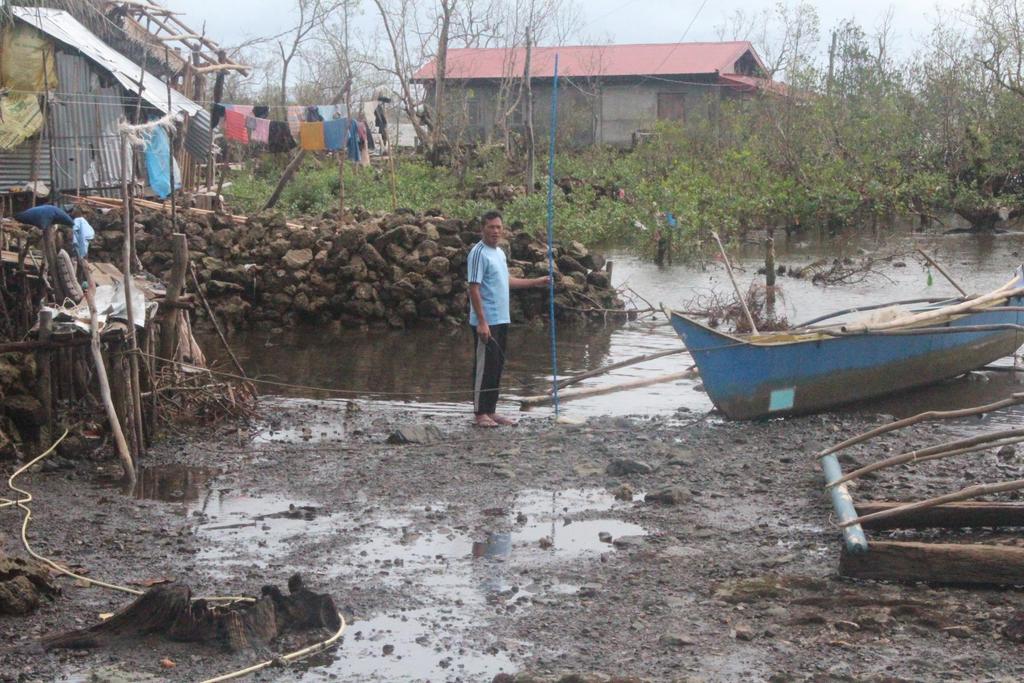
20 Impacts of Typhoon Yolanda Tacloban City

21 Impacts of Typhoon Yolanda


22 AFTER Typhoon Yolanda Source: Digital Globe BEFORE Typhoon Yolanda Source: Digital Globe Several coastal barangays were wiped out THE AFTERMATH Damages incurred by Typhoon Yolanda


23 AFTER Typhoon Yolanda THE AFTERMATH Damages incurred by Typhoon Yolanda BEFORE Typhoon Yolanda Source: Digital Globe Wind, surge and wave damages are enormous Source: Digital Globe


24 AFTER Typhoon Yolanda THE AFTERMATH Damages incurred by Typhoon Yolanda BEFORE Typhoon Yolanda Source: Digital Globe Economic activities were disrupted, and livelihoods were destroyed Source: Digital Globe
25 History of Typhoon Passages Near Tacloban,Leyte From records dating 1897 to 2013, many typhoons hit Visayas area, however 5 strong typhoons landed near Tacloban with notable damages/fatalities: Date of Typhoon Station Pressure Fatalities Occurrence 12 October , hpa 24 November hpa 27 October hpa 04 November , hpa 08 November , hpa Dangerous Typhoons Tracks STORM SURGE 7.3 m (Hernani) 7 m (Sta. Rita) No record 3.5 m (coastal areas of Leyte) 6-7 m ( Leyte & Samar areas) Earlier events are recorded in the following documents: - Philippine Weather Bureau Monthly Bulletins, Hongkong Observatory, 1958, re-edited - Shanghai Observatory, 1957, re-edited - JMA Library, Japan 2013 Typhoon Yolanda is just a repeat of what happened in the past except that the damage is highest because more people and infrastructure moved into harm s way.
26 Actions Undertaken By PAGASA During the Approach and Passage of Typhoon YOLANDA (HAIYAN)
27 Nov. 5 and 6 (11Am): Issued Weather Advisories regarding the approaching Typhoon Yolanda (Haiyan) Nov. 6 (11Pm): Issued Regular Typhoon Bulletin even though it was still outside Philippine Area of Responsibility (PAR) Nov. 6: The Department of Science and Technology (DOST) as Vice-Chair of the National Disaster Risk Reduction and Management Council (NDRRMC), initiated NDRRMC members to convened and conducted press conference after the meeting, for the preparations and early evacuation in areas to be affected by TY Yolanda (Haiyan).
28 Nov. 6-9: PAGASA Conducted Press Conferences and Press Briefings every 6 hours starting 5:00PM, Nov. 6 Frequent briefing at Malacanang The President broadcasted in tri-media about the strong Typhoon Yolanda (Haiyan)12 hours before landfall.
29 Hourly updates on the location and intensity of the typhoon ( Ptv 4, posted in the website, twitter, facebook and SMS). Detailed Meteorologists at the OCD(NDRRMC) Operation Center. Deployed a team of Storm Chasers to Sorsogon who proceeded to Samar and Leyte after the typhoon passage.
30 Meteorological Aspects Sent meteorologists from Central Office to Visayas PAGASA Regional Center and to Iloilo, Nov. 6-11, 2013 to assist the station in the dissemination of warnings and conduct assessment after the typhoon passage. Issued daily weather updates for the relief, rescue and rehabilitation of the affected areas. Nov. 11: Another Response Team composed of engineers, meteorologists and technicians were sent to Samar and Leyte. They also brought food and other emergency supplies for PAGASA personnel.
31 Activities of the Response Teams Temporary transfer of Tacloban synoptic station to DOST Region 8 Office in Palo, Leyte and installed basic weather instruments. Three (3) solar panels were put up for temporary lighting system and radio communication (SSB) at DOST R8 in Palo, Leyte, in Catbalogan and in Guiuan stations. Repaired water line at Guiuan station Repaired the generator sets of Tacloban, Catbalogan and Catarman stations. Re-installed all basic instruments in all affected PAGASA stations.

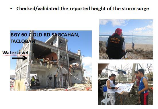
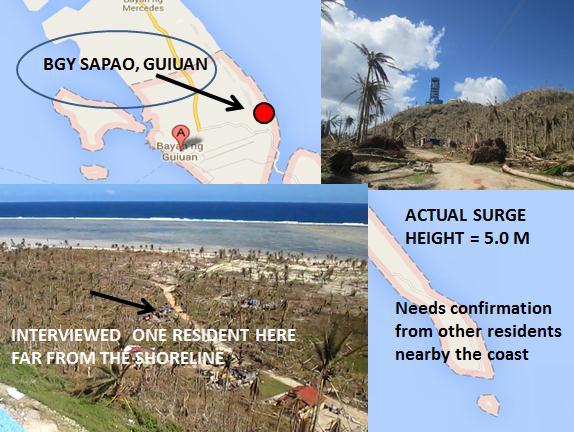
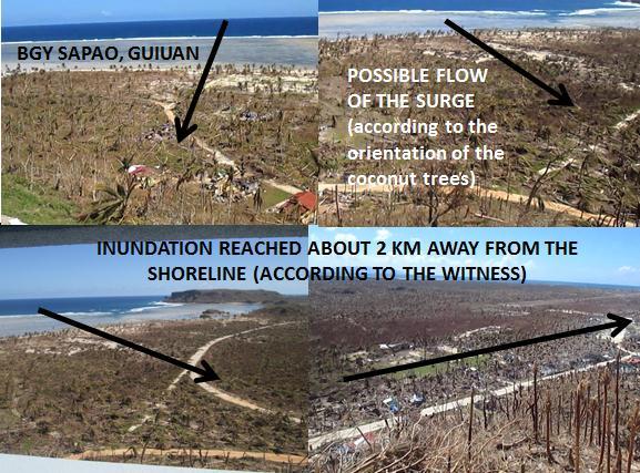
32 Survey storm surge heights (STORM CHASER Team) Basey Samar 5 to 6 meters with inundation of 600 to 800 meters. Tacloban to Palo Leyte 5 to 6 meters with inundation of 600 to 800 meters. Hernani Guiuan to Hernani Eastern Samar 6 to 7 meters with inundation of 800 to 1000 meters.
33
34
35
36
37


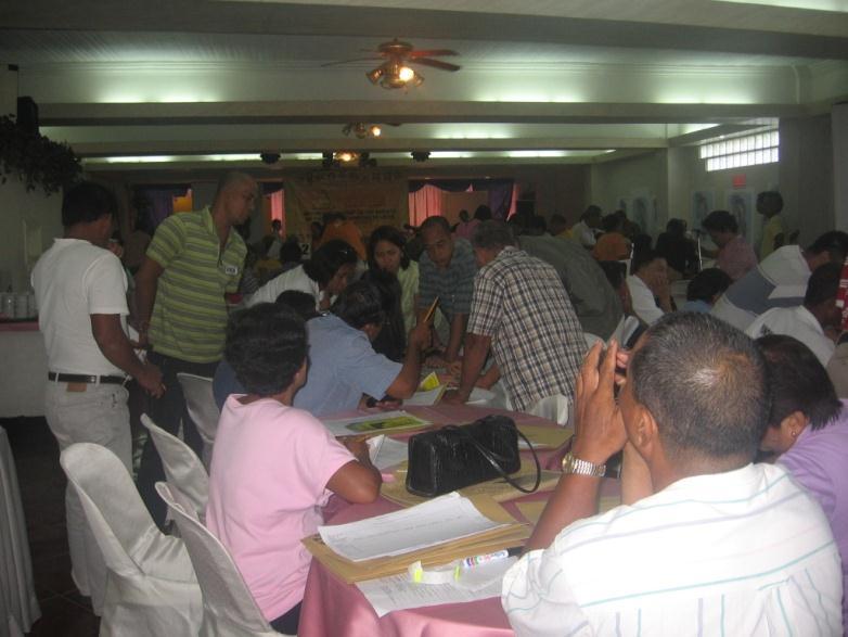
38 IEC for Teachers and LGUs in Tacloban and Palo, Leyte
39 Problems(Lessons Learned) During the Rescue and Relief Operations No communication available No power supply Heavy equipments and other vehicles were temporarily inoperational Impassable roads Relief goods stored in the provinces and regions were damaged and washaway
40 Meteorological Aspects Problems(Lessons Learned) During the Rescue and Relief Operations Members of the Local Disaster Groups were also victims and cannot do their job Local officials were also affected (take charge) Airport in the area were temporary inoperational
41 Meteorological Aspects Lessons Learned (Problems) People were not aware of the destructive power of Storm Surge (video) Proper implementation of contingency plan for every hazard Availability of Hazard Maps (implementation) People do not heed to the advice of the Disaster Managers / LGUs

42 tracking the sky... helping the country
PAGASA s Expectations of New-generation Satellites for Hazard Monitoring
 Country Report Philippines PAGASA s Expectations of New-generation Satellites for Hazard Monitoring VICENTE P. PALCON, JR. (Assistant Weather Services Chief) Weather Division- PAGASA DOST Email: vppalconjr@pagasa.dost.gov.ph
An Application of Hydrometeorological Information
 An Application of Hydrometeorological Information Weather-proof Café: Hydro-meteorological information in managing weather risks 17 19 November 2012 National Taiwan University, Chinese Taipei Nikos Viktor
TYPHOON HAIYAN. Known as typhoon Yolanda in the Philippines. Most powerful storm to make landfall in recorded history
 TYPHOON HAIYAN Known as typhoon Yolanda in the Philippines Most powerful storm to make landfall in recorded history Worst hit provinces: Leyte and Eastern Samar with a combined population of 2.3 M Experienced
Storm Surge Forecasting and Warning in the Philippines
 Storm Surge Forecasting and Warning in the Philippines 3 rd Masterclass on Disaster Mitigation APAN46 Asia Pacific Advanced Network Meeting 08 August 2018 Jehan Fe S. Panti PAGASA-DOST jspanti@pagasa.dost.gov.ph
Development of Tropical Storm Falcon (Meari) over the Philippines
 over the Philippines") Development of Tropical Storm Falcon (Meari) over the Philippines June 20-27, 2011 At the end of June, 2011, the Philippines were struck again by Tropical storm Falcon (Meari). After gaining strength over
Development of Tropical Storm Falcon (Meari) over the Philippines June 20-27, 2011 At the end of June, 2011, the Philippines were struck again by Tropical storm Falcon (Meari). After gaining strength over
EDNA L. JUANILLO Philippines
 Typhoon GLEnDA [RAMMASUN] EDNA L. JUANILLO Philippines TY GLENDA (RAMMASUN) (July 13-17, 2014) OTHER RELATED INFO It formed as a Tropical Depression (TD) over the Caroline Islands, Pacific Ocean, moving
The Role of PAGASA in Disaster Mitigation
 The Role of PAGASA in Disaster Mitigation Christopher F. Perez 2017 ACTS Workshop on Extreme Weather Forecast and Water Resource Management Hanoi, Vietnam September 26-27, 2017 Tropical Storm AMANG(Mekkhala),
Overview of Philippine Geohazards Programs
 Overview of Philippine Geohazards Programs 53 rd CCOP Annual Session CCOP-IUGS Task Group on Geohazards Joint Seminar Cebu City, PHILIPPINES October 18, 2017 Renato U. Solidum, Jr. Department of Science
Community-Based Flood Early Warning System (CBFEWS)
") Community-Based Flood Early Warning System (CBFEWS) Prepared by: Eng r. Hilario G. Esperanza Eng r.. Socrates F. Paat,, Jr. Flood Forecasting Branch PAGASA Weather Bureau Department of Science and Technology
Community-Based Flood Early Warning System (CBFEWS) Prepared by: Eng r. Hilario G. Esperanza Eng r.. Socrates F. Paat,, Jr. Flood Forecasting Branch PAGASA Weather Bureau Department of Science and Technology
National Report on Weather Forecasting Service
 MINISTRY OF WATER RESOURCES AND METEOROLOGY DEPARTMENT OF METEOROLOGY, CAMBODIA National Report on Weather Forecasting Service Tokyo, 11-15 March 2014 Department of Meteorology, Cambodia Presentation Outline
Earth Observation & forecasting Storm Surges in the North Western Pacific. Mr. Nadao Kohno Japan Meteorological Agency
 Earth Observation & forecasting Storm Surges in the North Western Pacific Mr. Nadao Kohno Japan Meteorological Agency Lesson Outline Introduction JMA s responsibility and work as a RSMC, Tokyo Typhoon
The Philippines modified its Tropical Cyclone Warning System
 The Philippines modified its Tropical Cyclone Warning System Historical Background As an archipelago in Western North Pacific, the Philippines is exposed to tropical cyclones of varying intensity and impacts
2014/2/25. Earth Observation & forecasting Storm Surges in the North Western Pacific. Lesson Outline. RSMC Tokyo Typhoon Center.
 Earth Observation & forecasting Storm Surges in the North Western Pacific Mr. Nadao Kohno Japan Meteorological Agency Lesson Outline Introduction JMA s responsibility and work as a RSMC, Tokyo Typhoon
DAGUPAN CITY EXPERIENCES, GOOD PRACTICES, CHALLENGES AND LESSONS LEARNED ON DISASTER RISK MANAGEMENT
 DAGUPAN CITY EXPERIENCES, GOOD PRACTICES, CHALLENGES AND LESSONS LEARNED ON DISASTER RISK MANAGEMENT Reducing Vulnerability to Climate Change Impacts and Related Natural Disasters in East Asia 12 and 13
EFFECTIVE TROPICAL CYCLONE WARNING IN BANGLADESH
 Country Report of Bangladesh On EFFECTIVE TROPICAL CYCLONE WARNING IN BANGLADESH Presented At JMA/WMO WORKSHOP ON EFFECTIVE TROPICAL CYCLONE WARNING IN SOUTHEAST ASIA Tokyo, Japan,11-14 March 2014 By Sayeed
The Politics of Tornadoes The Impacts of Sudden Storm Events on People
 The Politics of Tornadoes The Impacts of Sudden Storm Events on People Today s Discussion Brief Review Student Presentation When the Sky Kills Impacts of Tornadoes Questions & Discussion Next Class Brief
Evacuation Alarm Using the Improved Magnitude Method to Damage Caused by Typhoon 9918
 ICHE 2014, Hamburg - Lehfeldt & Kopmann (eds) - 2014 Bundesanstalt für Wasserbau ISBN 978-3-939230-32-8 Evacuation Alarm Using the Improved Magnitude Method to Damage Caused by Typhoon 9918 R. Hashimura
Impact of Tropical Cyclones - Malaysia's Experience
 Impact of Tropical Cyclones - Malaysia's Experience ALUI BAHARI MALAYSIAN METEOROLOGICAL DEPARTMENT MINISTRY OF SCIENCE, TECHNOLOGY AND INNOVATION SCOPE Introduction Case Studies of Tropical Cyclones Impacting
Tropical Cyclone Warning System in the Philippines
 Republic of the Philippines Department of Science and Technology PHILIPPINE ATMOSPHERIC GEOPHYSICAL AND ASTRONOMICAL SERVICES ADMINISTRAION (PAGASA) Science Garden Compound, Agham Road, Diliman, Quezon
GENERAL. CHAPTER 1 BACKGROUND AND PURPOSE OF THE GUIDELINES Background of the Guidelines Purpose of the Guidelines...
 GENERAL CHAPTER 1 BACKGROUND AND PURPOSE OF THE GUIDELINES... 1 1.1 Background of the Guidelines... 1 1.2 Purpose of the Guidelines... 3 CHAPTER 2 APPLICATION OF THE GUIDELINES... 3 2.1 Potential Users
Weather forecasts and warnings: Support for Impact based decision making
 Weather forecasts and warnings: Support for Impact based decision making Gerry Murphy, Met Éireann www.met.ie An Era of Change Climate and weather is changing Societal vulnerability is increasing The nature
Briefing on the WMO Support to Viet Nam to cope with Typhoon Haiyan
 WMO Briefing on the WMO Support to Viet Nam to cope with Typhoon Haiyan A Case of WMO Emergency Response Typhoon Haiyan trajectory Background Typhoon Haiyan remained strong after devastating the Philippines
Progress Report. Flood Hazard Mapping in Thailand
 Progress Report Flood Hazard Mapping in Thailand Prepared By: Mr. PAITOON NAKTAE Chief of Safety Standard sub-beuro Disaster Prevention beuro Department of Disaster Prevention and Mitigation THAILAND E-mail:
JMA/WMO WORKSHOP ON EFFECTIVE TROPICAL CYCLONE WARNING IN SOUTHEAST ASIA
 JMA/WMO WORKSHOP ON EFFECTIVE TROPICAL CYCLONE WARNING IN SOUTHEAST ASIA TROPICAL CYCLONE MONITORING IN LAO PDR TOKYO, JAPAN 11 14 March 2014 Ministry of Natural Resource and Environment (MONRE) Department
Enhancing Preparedness and Early Warning in Disaster Risk Reduction
 Enhancing Preparedness and Early Warning in Disaster Risk Reduction Fifth Technical Conference on Management of Meteorological and Hydrological Services in Regional Association V at PETALING JAYA, MALAYSIA
South African Weather Service. Description of Public Weather and Warning Services. Tshepho Ngobeni. 18 November 2013
 South African Weather Service Description of Public Weather and Warning Services Tshepho Ngobeni 18 November 2013 SAWS-SWFDP_PRES_18-22_Nov_2013 1 Outline Forecasting Descriptions and Processes Severe
Pacific Catastrophe Risk Assessment And Financing Initiative
 Pacific Catastrophe Risk Assessment And Financing Initiative VANUATU September 211 Country Risk Profile: VANUATU is expected to incur, on average, 48 million USD per year in losses due to earthquakes and
GC Briefing. Weather Sentinel Tropical Storm Michael. Status at 8 AM EDT (12 UTC) Today (NHC) Discussion. October 11, 2018
 Today (NHC) Discussion. October 11, 2018") GC Briefing Weather Sentinel Tropical Storm Michael October 11, 2018 After making landfall as a high-end category-4 hurricane on the Florida Panhandle, Michael weakened to tropical storm status early this
GC Briefing Weather Sentinel Tropical Storm Michael October 11, 2018 After making landfall as a high-end category-4 hurricane on the Florida Panhandle, Michael weakened to tropical storm status early this
Very Dangerous Coastal Storm Sandy October 28 th 31 st 2012
 Very Dangerous Coastal Storm Sandy October 28 th 31 st 2012 Prepared 600 PM EDT Monday October 29, 2012 Gary Szatkowski NOAA s NJ Forecast Office Weather.gov/phi Purpose of Briefing Briefing #11 for event
Activities and Outlook related to Disaster Reduction in CMA
 Activities and Outlook related to Disaster Reduction in CMA WANG Bangzhong China Meteorological Administration March 15-17 2006 ADENDA Situation about MD and related disasters in CHINA Guidance for MD/RD
 Hazard Warnings GE 4150 Natural Hazards September 17, 2007 http://www.sdr.gov/ndis_rev_oct27.pdf Sorensen, J.H. (2000) Hazard warning systems: Review of 20 years of progress. Natural Hazards Review, May,
Charles Kuster Leadville, CO. Personal Overview
 Charles Kuster Leadville, CO Personal Overview Personal Overview Charles Kuster Leadville, CO OU to study meteorology Charles Kuster Leadville, CO Personal Overview OU to study meteorology Graduated in
Hurricane Sandy October 28 th 31 st 2012
 Hurricane Sandy October 28 th 31 st 2012 Prepared 530 PM EDT Saturday October 27, 2012 Gary Szatkowski NOAA s NJ Forecast Office Weather.gov/phi Purpose of Briefing Briefing #7 for event Promote situational
CAIRNS AIRPORT CYCLONE PLAN
 CAIRNS AIRPORT CYCLONE PLAN Reference No: 2046 SO Version 5 25 th October 2017 2046_SO_CairnsAirportCyclonePlan_V5_Effectivedate_25/10/2017_Reviewdate_25/10/2018 Page 1 of 10 Document Control Reference
Hazard Warnings and Warning Systems
 Hazard Warnings and Warning Systems Lecture Objectives: -Know the main features and limitations of our national warning system -learn the key features of an effective warning system Sorensen, J.H. (2000)
WEATHER SYSTEMS IMPACTING THE CAYMAN ISLANDS Prepared by the staff of the Cayman Islands National Weather Service
 WEATHER SYSTEMS IMPACTING THE CAYMAN ISLANDS 2008 Prepared by the staff of the Cayman Islands National Weather Service TROPICAL STORM DOLLY Formed 194 miles west of Grand Cayman July 19 th. The tropical
THE IMPACT OF WEATHER
 The United States is the most severe weather prone country in the world. Each year, people in this country cope with an average of 10,000 thunderstorms, 5,000 floods, 1,200 tornadoes and two landfalling
Peterborough Distribution Inc Ashburnham Drive, PO Box 4125, Station Main Peterborough ON K9J 6Z5
 Peterborough Distribution Inc. 1867 Ashburnham Drive, PO Box 4125, Station Main Peterborough ON K9J 6Z5 November 15, 2017 Ontario Energy Board PO Box 2319 27 th Floor, 2300 Yonge St Toronto ON M4P 1E4
photo courtesy of
 BRITISH VIRGIN ISLANDS REPORT TROPICAL STORM JEANNE photo courtesy of www.bviplatinum.com PREPARED BY THE DEPARTMENT OF DISASTER MANAGEMENT 1 EVENT 13 th -16 th September, 2004 TROPICAL STORM JEANNE Sequence
H.3 Severe Impacts of Hurricane Irma in Cuba: Forecast Models, Forecast and Warning Processes.
 H.3 Severe Impacts of Hurricane Irma in Cuba: Forecast Models, Forecast and Warning Processes. Jose Rubiera Institute of Meteorology, La Habana, Cubauba Special Session: Recent high-impact landfalling
Highlights. Situation Overview
 Situation report issued by NDMO Vanuatu This report covers the period from 10 March 2015 Highlights Tropical Cyclone Pam Cat 3 enters Vanuatu grid at 8:00 on 11 March 2013. The Vanuatu Met Services has
Tropical Update. 11 AM EDT Wednesday, October 10, 2018 Hurricane Michael, Hurricane Leslie & Tropical Storm Nadine, Caribbean Low (40%)
") Tropical Update 11 AM EDT Wednesday, October 10, 2018 Hurricane Michael, Hurricane Leslie & Tropical Storm Nadine, Caribbean Low (40%) This update is intended for government and emergency response officials,
Tropical Update 11 AM EDT Wednesday, October 10, 2018 Hurricane Michael, Hurricane Leslie & Tropical Storm Nadine, Caribbean Low (40%) This update is intended for government and emergency response officials,
Fenui e-newsletter is publicized with the approval of the Tuvalu Media General Manager Melali Taape
 Publication of Tuvalu Media Department Government of Tuvalu Email: fenui@gov.tv Fenui e-newsletter is publicized with the approval of the Tuvalu Media General Manager Melali Taape Stories this week: Press
Major Hurricane Matthew Briefing Situation Overview
 Major Hurricane Matthew Briefing Situation Overview At 5 p.m. Tuesday, Category 4 Hurricane Matthew was about 860 miles South-Southeast of Mayport, Florida, moving north around 10 mph. Maximum sustained
Daily Operations Briefing Friday, November 15, :30 a.m. EST
 Daily Operations Briefing Friday, November 15, 2013 8:30 a.m. EST 1 Significant Activity: Nov 14 15 Significant Events: Super Typhoon Haiyan (Final) Tropical Activity: Atlantic Pacific Tropical cyclone
JICA s Cooperation for NMHSs. Taisuke Watanabe Japan International Cooperation Agency
 JICA s Cooperation for NMHSs Taisuke Watanabe 28 Oct, 2014 JICA s Assistant Approach for Hydrological and Meteorological Services Assistance for improvement of Hydrological and Meteorological Services
Typhoon Haima (Lawin) Report #4 20 October 2016, 3.00PM PHT. Manila Observatory
 Report #4 20 October 2016, 3.00PM PHT. Manila Observatory") Typhoon Haima (Lawin) Report #4 20 October 2016, 3.00PM PHT Manila Observatory SUMMARY PAGASA reports eye of Super Typhoon Haima (Bagyong Lawin) located at 18.5 N, 119.7 E (as of 10 AM Oct 20) with max
Typhoon Haima (Lawin) Report #4 20 October 2016, 3.00PM PHT Manila Observatory SUMMARY PAGASA reports eye of Super Typhoon Haima (Bagyong Lawin) located at 18.5 N, 119.7 E (as of 10 AM Oct 20) with max
Tokyo, Japan March Discussed By: May Khin Chaw, Kyaw Lwin Oo. Department of Meteorology and Hydrology
 Tokyo, Japan 11-14 March 2014 Discussed By: May Khin Chaw, Kyaw Lwin Oo Department of Meteorology and Hydrology Manpower: Out of DMH s total (1425), we are Working with (780) Staffs. 55% (37) stations
2008 Hurricane Caravan. Daniel Noah Meteorologist National Weather Service x1 May 22, 2008
 2008 Hurricane Caravan Daniel Noah Meteorologist National Weather Service daniel.noah@noaa.gov, 813-645-2323 x1 May 22, 2008 National Weather Service We never close! Open 24 hours a day 365 days per year
Hurricane Preparation and Recovery. October 11, 2011 Jon Nance, Chief Engineer, NCDOT
 Hurricane Preparation and Recovery October 11, 2011 Jon Nance, Chief Engineer, NCDOT North Carolina & Severe Weather Our state often bears the brunt of storms, which include: Ice storms Snow storms Heavy
PACIFIC RING OF FIRE. Photo credit: wikipedia.org
 PACIFIC RING OF FIRE Photo credit: wikipedia.org PACIFIC TYPHOON PATH Photo credit: ucar.edu EXPORTER OF TYPHOONS Tracks of Tropical Cyclones in the Western North Pacific from 1948 to 2010. Ref: Japan
CAIRNS AIRPORT CYCLONE PLAN
 CAIRNS AIRPORT CYCLONE PLAN Reference No: 2046 SO Version 5.1 6 th February 2018 2046_SO_CairnsCyclonePlan_V5.1_Effectivedate_06/02/2018_Reviewdate_06/02/2019 Page 1 of 10 Document Control Reference No
Use of big data, crowdsourcing and GIS in assessment of weather-related impact
 Use of big data, crowdsourcing and GIS in assessment of weather-related impact HK (Photo courtesy : GFS) PAN Chi-kin, Hong Kong Observatory (Photo courtesy : Roy Liu/China Daily) November 2017, KMA/WMO
Satellite Data Utilization and Meteorological Hazard Prevention In the Philippines
 Joint Integrated Global Water Cycle Observing(IGWCO)/ Coordinated Enhanced Observing Period (CEOP) Workshop 28 Feb. 4 March 2005, Tokyo, Japan Satellite Data Utilization and Meteorological Hazard Prevention
Typhoon Hagupit (Ruby) Disaster Risk Reduction Situation Report 1 DRR sitrep updated December 4, 2014, 15:00 CET
 Disaster Risk Reduction Situation Report 1 DRR sitrep updated December 4, 2014, 15:00 CET") Typhoon Hagupit (Ruby) Disaster Risk Reduction Situation Report 1 DRR sitrep 2014 002 updated December 4, 2014, 15:00 CET Summary Report Ongoing typhoon situation Typhoon Hagupit, locally named "Ruby",
Typhoon Hagupit (Ruby) Disaster Risk Reduction Situation Report 1 DRR sitrep 2014 002 updated December 4, 2014, 15:00 CET Summary Report Ongoing typhoon situation Typhoon Hagupit, locally named "Ruby",
Pacific Catastrophe Risk Assessment And Financing Initiative
 Pacific Catastrophe Risk Assessment And Financing Initiative PALAU September is expected to incur, on average,.7 million USD per year in losses due to earthquakes and tropical cyclones. In the next 5 years,
NWS HURRICANES June 3, 2015
 NWS HURRICANES June 3, 2015 Hurricane Season June 1 November 30 2 What s the concern? All tropical systems passing within 125nm of central Maryland since 1950 Mid-Atlantic Hurricanes Greatest Risk: August
CLIMATE SERVICES for the AGRICUTURAL SECTOR in the PHILIPPINES
 CLIMATE SERVICES for the AGRICUTURAL SECTOR in the PHILIPPINES EDNA L. JUANILLO Weather Services Chief, PAGASA Technical Conference on Future Challenges and Opportunities in Agricultural Meteorology 16-17
Hurricane Readiness for Coastal Communities
 Hurricane Readiness for Participant Guide Developed for: Federal Emergency Management Agency Emergency Management Institute 16825 South Seton Avenue Emmitsburg, MD 21727-8998 Developed by: C² Technologies,
Careful, Cyclones Can Blow You Away!
 Title: Careful, Cyclones Can Blow You Away! (Meteorology) Grade(s): 6-8 Introduction: Most people associate twisters with tornadoes, but in fact tropical twisters come from hurricanes. Hurricanes are what
Communications and Lessons Learned from
 Weather Forecast Office Charleston, SC Communications and Lessons Learned from Southeast and Caribbean and Climate Community of Practice - April, 2017 Public Information and Communications During Extremes
Smart use of Geographic Information System (GIS) platform for delivering weather information and nowcasting services
 platform for delivering weather information and nowcasting services") Smart use of Geographic Information System (GIS) platform for delivering weather information and nowcasting services C. K. Pan Hong Kong Observatory Hong Kong, China It is a world of beauty Source: Image
Smart use of Geographic Information System (GIS) platform for delivering weather information and nowcasting services C. K. Pan Hong Kong Observatory Hong Kong, China It is a world of beauty Source: Image
Initiative. Country Risk Profile: papua new guinea. Better Risk Information for Smarter Investments PAPUA NEW GUINEA.
 Pacific Catastrophe Risk Assessment And Financing Initiative PAPUA NEW GUINEA September 211 Country Risk Profile: papua new is expected to incur, on average, 85 million USD per year in losses due to earthquakes
CHAPTER 13 WEATHER ANALYSIS AND FORECASTING MULTIPLE CHOICE QUESTIONS
 CHAPTER 13 WEATHER ANALYSIS AND FORECASTING MULTIPLE CHOICE QUESTIONS 1. The atmosphere is a continuous fluid that envelops the globe, so that weather observation, analysis, and forecasting require international
Typhoon Haima (Lawin) Report #3 20 October 2016, 9.00AM PHT. Manila Observatory
 Report #3 20 October 2016, 9.00AM PHT. Manila Observatory") Typhoon Haima (Lawin) Report #3 20 October 2016, 9.00AM PHT Manila Observatory SUMMARY PAGASA reports eye of Super Typhoon Haima (Bagyong Lawin) located at 18.4 N, 120.3 E (as of 7 AM Oct 20) with max
Typhoon Haima (Lawin) Report #3 20 October 2016, 9.00AM PHT Manila Observatory SUMMARY PAGASA reports eye of Super Typhoon Haima (Bagyong Lawin) located at 18.4 N, 120.3 E (as of 7 AM Oct 20) with max
Improving global coastal inundation forecasting WMO Panel, UR2014, London, 2 July 2014
 Improving global coastal inundation forecasting WMO Panel, UR2014, London, 2 July 2014 Cyclone Sidr, November 2007 Hurricane Katrina, 2005 Prof. Kevin Horsburgh Head of marine physics, UK National Oceanography
Tropjcal Cyclone Warning and Response Mulipola A. Titimaea (ACEO-Met) Filomena Nelson (ACEO-Disaster Management
 Filomena Nelson (ACEO-Disaster Management") Tropjcal Cyclone Warning and Response Mulipola A. Titimaea (ACEO-Met) Filomena Nelson (ACEO-Disaster Management Overview Monitoring & Warnings Case study Tropical Cyclone Evans, 11-15 December 2012 Responses
Tropjcal Cyclone Warning and Response Mulipola A. Titimaea (ACEO-Met) Filomena Nelson (ACEO-Disaster Management Overview Monitoring & Warnings Case study Tropical Cyclone Evans, 11-15 December 2012 Responses
Major Hurricane Matthew Briefing Situation Overview
 Major Hurricane Matthew Briefing Situation Overview THIS IS NOW A WORST CASE STORM SURGE SCENARIO Catastrophic Damage is Anticipated for Coastal Areas. Major Hurricane Matthew is still expected to move
CYCLONE POLICY & PROCEDURE
 CYCLONE POLICY & PROCEDURE Last updated Oct 2016 Rationale St Mary s Catholic Primary School is committed to providing a safe and healthy working environment for all persons who could be at risk in the
Complete Weather Intelligence for Public Safety from DTN
 Complete Weather Intelligence for Public Safety from DTN September 2017 White Paper www.dtn.com / 1.800.610.0777 From flooding to tornados to severe winter storms, the threats to public safety from weather-related
Marshall Alexander Forecaster Commonwealth of Dominica
 Marshall Alexander Forecaster Commonwealth of Dominica Dominica 2015 Impacts Tropical Storm Danny (August 24 th ) Tropical Storm Erika (August 27 th ) Tropical Storm Grace (Remnants) (September 10 th -11
The WMO Tropical Cyclone Programme(TCP)
") The WMO Tropical Cyclone Programme(TCP) Session 4: Insights into some WMO ProgrammeActivities to Support MHEWS at National, Regional and Global Levels UI-EAG MHEWS, 19-21 April 2016, Geneva Anne-Claire
The WMO Tropical Cyclone Programme(TCP) Session 4: Insights into some WMO ProgrammeActivities to Support MHEWS at National, Regional and Global Levels UI-EAG MHEWS, 19-21 April 2016, Geneva Anne-Claire
Disaster Risk Management in India. Kamal Kishore New Delhi, 27 October 2016
 Disaster Risk Management in India Kamal Kishore New Delhi, 27 October 2016 Hazard, Exposure and Vulnerability Disaster Prevention Mitigation Hurricane Matthew: Cuba & Haiti Emergency Response Coordination
Daily Operations Briefing Sunday, November 10, :30 a.m. EST
 Daily Operations Briefing Sunday, November 10, 2013 8:30 a.m. EST 1 Significant Activity: Nov 9-10 Significant Events: GOCE Satellite Re-entry Tropical Activity: Atlantic/Eastern Pacific No tropical cyclone
Case Studies in Communication Challenges: Hurricane Sandy
 Case Studies in Communication Challenges: Hurricane Sandy International Workshop on Tropical Cyclones Jeju Island, South Korea Chris Landsea, National Hurricane Center, RSMC Miami Major Hurricane Sandy
MEMBER REPORT CAMBODIA. Forty-fifth Session of the ESCAP/WMO Typhoon Committee Hongkong, China 29 January-1 February 2013
 MEMBER REPORT CAMBODIA Forty-fifth Session of the ESCAP/WMO Typhoon Committee Hongkong, China 29 January-1 February 2013 CONTENTS I. Overview of tropical cyclone which have affected /impacted Kingdom of
City of Punta Gorda Community Emergency Management Plan 2013
 City of Punta Gorda Community Emergency Management Plan 2013 Hurricane Andrew- August 24, 1992 Category 5 hurricane. The second-most-destructive hurricane in U.S. history. The first named storm of the
National Public Weather and Warning Services in the Swaziland Meteorological Service Dennis S.Mkhonta /
 National Public Weather and Warning Services in the Swaziland Meteorological Service Dennis S.Mkhonta dennis.mkhonta@gmail.com / dennis@swazimet.gov.sz Introduction Swaziland s geographical position exposes
Background Unified Mapping Project of NAMRIA Mapping of Typhoon-Affected Areas Final Output Conclusion
 www.namria.gov.ph Background Unified Mapping Project of NAMRIA Mapping of Typhoon-Affected Areas Final Output Conclusion Typhoon Haiyan (local name Yolanda) the deadliest most destructive typhoon in recorded
Recent development of the National Hydro-Meteorological Service (NHMS) of Viet Nam for disaster risk reduction
 of Viet Nam for disaster risk reduction") Ministry of Natural Resources and Environment National Hydro-Meteorological Service Recent development of the National Hydro-Meteorological Service (NHMS) of Viet Nam for disaster risk reduction Tran Van
Ministry of Natural Resources and Environment National Hydro-Meteorological Service Recent development of the National Hydro-Meteorological Service (NHMS) of Viet Nam for disaster risk reduction Tran Van
Tropical Update. 5 AM EDT Tuesday, September 12, 2017 Post-Tropical Cyclone Irma, Hurricane Jose, & Tropical Wave (10%)
") Tropical Update 5 AM EDT Tuesday, September 12, 2017 Post-Tropical Cyclone Irma, Hurricane Jose, & Tropical Wave (10%) This update is intended for government and emergency response officials, and is provided
Tropical Update 5 AM EDT Tuesday, September 12, 2017 Post-Tropical Cyclone Irma, Hurricane Jose, & Tropical Wave (10%) This update is intended for government and emergency response officials, and is provided
Welcome Jeff Orrock Warning Coordination Meteorologist National Weather Service Raleigh
 Welcome Jeff Orrock Warning Coordination Meteorologist National Weather Service Raleigh Jeff.orrock@noaa.gov Sources: Operational Significant Event Imagery and the Environmental Applications Team (EAT)
Canadian Hurricane Center: How NHC Products are used to issue Warnings and Communicate Hazards
 Canadian Hurricane Center: How NHC Products are used to issue Warnings and Communicate Hazards Bob Robichaud Warning Preparedness Meteorologist Canadian Hurricane Centre Contents Brief background on the
Pacific Catastrophe Risk Assessment And Financing Initiative
 Pacific Catastrophe Risk Assessment And Financing Initiative TIMOR-LESTE September Timor-Leste is expected to incur, on average, 5.9 million USD per year in losses due to earthquakes and tropical cyclones.
Hurricane Matthew. Life Threatening Flash Flooding Likely. National Weather Service Wilmington NC. Josh Weiss, Meteorologist
 Hurricane Matthew Life Threatening Flash Flooding Likely Threat Assessment for northeast South Carolina & southeast North Carolina National Weather Service Wilmington NC 630 PM EDT Friday October 7, 2016
Frank Revitte National Weather Service. Weather Forecast Office New Orleans/Baton Rouge
 Frank Revitte National Weather Service Weather Forecast Office New Orleans/Baton Rouge Above normal activity 17 Total Named Storms 7 Tropical Storms 4 Hurricanes 6 Major Hurricanes Not the most active,
Improvement of Hazard Assessment and Management in the Philippines
 Improvement of Hazard Assessment and Management in the Philippines (2014 Summer Training Course for Slope Land Disaster Reduction) Ian Alejandrino (Philippines) Nguyen Manh Hieu (Vietnam) Presentation
UDOT Weather Program Traffic Operations Center
 UDOT Weather Program Traffic Operations Center Presentation Goals You MUST account for weather in your Traffic Management program Provide you with information on proven tools and strategies You NEED a
Joint Meeting of RA II WIGOS Project and RA V TT-SU on 11 October 2018 BMKG Headquarter Jakarta, Indonesia. Mrs. Sinthaly CHANTHANA
 Joint Meeting of RA II WIGOS Project and RA V TT-SU on 11 October 2018 BMKG Headquarter Jakarta, Indonesia Mrs. Sinthaly CHANTHANA Lao PDR Background Department of Meteorology and Hydrology ( DMH ) in
The Nuts and Bolts of These Community Preparedness Recognition Programs
 The Nuts and Bolts of These Community Preparedness Recognition Programs Bill Sammler Warning Coordination Meteorologist NOAA s National Weather Service, Wakefield VA http://weather.gov/akq Why is StormReady
Impact of Cyclone Nargis
 Lessons Learnt from Nargis Recovery for the Next Disaster International Recovery Forum (2011) 12, JAN 2011, Kobe, Japan Home for over 100 national races. Profile of Myanmar The 2 nd largest country in
CURRENT AND FUTURE TROPICAL CYCLONE RISK IN THE SOUTH PACIFIC
 CURRENT AND FUTURE TROPICAL CYCLONE RISK IN THE SOUTH PACIFIC COUNTRY RISK PROFILE: SAMOA JUNE 2013 Samoa has been affected by devastating cyclones on multiple occasions, e.g. tropical cyclones Ofa and
Tropical Revolving Storms: Cuba 2008 By The British Geographer
 Place Context Tropical Revolving Storms: Cuba 2008 By The British Geographer The Republic of Cuba is located in the northern tropics with in island chain of the Caribbean. It is made up of one large Island,
Pacific Catastrophe Risk Assessment And Financing Initiative
 Pacific Catastrophe Risk Assessment And Financing Initiative TUVALU is expected to incur, on average,. million USD per year in losses due to earthquakes and tropical cyclones. In the next 5 years, has
Hurricanes. Environmental Geology Mr. Paul Lowrey. Stacey Singleton, Cassandra Combs, Dwight Stephenson, Matt Smithyman
 Environmental Geology Mr. Paul Lowrey Stacey Singleton, Cassandra Combs, Dwight Stephenson, Matt Smithyman Hurricanes EMPACTS Project, Spring 2017 Northwest Arkansas Community College, Bentonville, AR
What Are Disasters? The Rescue Kids Trio!
 The Rescue Kids Trio! What Are Disasters? This manual was made possible through funding by the Council of Local Authorities for International Relations. Disasters and emergency preparedness Emergency preparedness
CAPACITY BUILDING AND DEVELOPMENT OF THE RIC IN MANILA (PHILIPPINES)
") CAPACITY BUILDING AND DEVELOPMENT OF THE RIC IN MANILA (PHILIPPINES) by Ferdinand Y. Barcenas 1 ABSTRACT The Regional Instrument Centre for the South-West Pacific in Manila, Philippines was recognized
CAPACITY BUILDING AND DEVELOPMENT OF THE RIC IN MANILA (PHILIPPINES) by Ferdinand Y. Barcenas 1 ABSTRACT The Regional Instrument Centre for the South-West Pacific in Manila, Philippines was recognized
Storm Surge Modelling at the JRC. A. Annunziato
 Storm Surge Modelling at the JRC A. Annunziato Storm Surge Activities The following modelling activities are carried out at JRC Tsunami wave height forecast Cyclones Storm Surge The activities are performed
Daily Operations Briefing Wednesday, November 6, :30 a.m. EST
 Daily Operations Briefing Wednesday, November 6, 2013 8:30 a.m. EST 1 Significant Activity: Nov 5 6 Significant Events: None Tropical Activity: Atlantic/Eastern Pacific No tropical cyclone activity expected
JMA/WMO WORKSHOP ON EFFECTIVE TROPICAL CYCLONE WARNING IN SOUTHEAST ASIA. Tokyo, Japan March 2014
 Annex IV JMA/WMO WORKSHOP ON EFFECTIVE TROPICAL CYCLONE WARNING IN SOUTHEAST ASIA Tokyo, Japan 11-14 March 2014 Country Report On Tropical Cyclone Monitoring In Cambodia Department of Meteorology 1 1.