Current tsunami research activities in the Philippines
|
|
|
- Lewis Francis
- 6 years ago
- Views:
Transcription
1 DOST PHIVOLCS Current tsunami research activities in the Philippines Graciano P. Yumul, Jr. 1,2, Carla B. Dimalanta 1 and Bart Bautista 3 1 National Institute of Geological Sciences, University of the Philippines, Diliman, Quezon City, Philippines 2 Department of Science and Technology, Bicutan, Taguig, Philippines 3 Philippine Institute of Volcanology and Seismology Department of Science and Technology, Diliman, Quezon City, Philippines


2 Objectives To present what the Philippines has been doing in terms of tsunami mitigation and to identify future directions Bautista, 2006
3 Outline Philippine setting Current activities in the Philippines Risk assessment Monitoring Warning Modeling Future directions

4 Tectonic map of Southeast Asia Indochina Sundaland- Eurasian Plate Philippines Philippine Trench Philippine Sea Plate Sumatra-Java Trench Sulawesi Sumatra Borneo New Guinea Java ftp://ftp.ngdc.noaa.gov/

5 Seismicity around the Philippines
6 Current activities Hazard and risk assessment Monitoring Warning Modeling

7 DOST PHIVOLCS Hazard and risk assessment Ko Puh, Thailand


8 Hazard and risk assessment Tsunami Hazard Assessment and Mitigation Program Tsunami Risk Mitigation Program Besana et al., 2005
 4. Manila Trench tsunamis 5. Sorsogon uplifted terraces 6.")
9 THAMP 1. Davao Oriental (1992 Manay tsunami) 2. Bohol island (1990 earthquake) 3. SW Mindanao (1976 Moro Gulf earthquake) 4. Manila Trench tsunamis 5. Sorsogon uplifted terraces 6. Paraoir porites and uplifted terraces Besana et al., 2005
10 Tsunami Risk Mitigation Program Assess risk and develop a model for tsunami preparedness, warning and evacuation at the local government level Increase the level of awareness and preparedness of vulnerable communities to tsunami hazards and risks Develop simple and low cost technology for tsunami detection and warning
11 DOST PHIVOLCS Monitoring and warning
12 Tsunami monitoring and warning Far field tsunami events (eastern seaboard): Pacific Tsunami Warning Center Northwest Pacific Tsunami Warning and Information Center
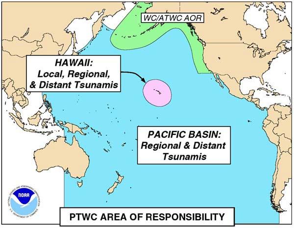
13 PTWC area of responsibility
")
14 Northwest Pacific Tsunami Warning and Information Center (Japan government) Bautista, 2006

15 Tsunami monitoring and warning Near-field tsunami events: Local tsunami warning system
16 Local tsunami warning system Real-time seismic monitoring system Real-time local tsunami detection system Rapid communication system Mass alerting system


17 National seismic monitoring network 30 satellite telemetered stations With real time data transmission 34 manned stations Equipped with SSB radios and telephones for non-real time data transmission 9 of the 34 manned stations have broadband instruments PHIVOLCS

18 Instrumentations in the satellite-telemetered unmanned stations of PHIVOLCS Batteries and solar charger regulator Seismic vault, solar panel and VSAT antenna Three component shortperiod sensors Digitizer and VSAT modem / transmitter

19 Tsunami detection network Real-time tsunami wave detection stations First station installed in Lubang Island, Mindoro (funded by government of Finland)


20 PHIVOLCS tsunami wet sensor Electric cable Water collecting vessel Air Vent The height of the tube and elevation of probes and collecting vessel could be adjusted to set the tsunami height measurement level (i.e. 1 m, 3 m, 6 m or 10 m) Stainless Tube Tsunami Water Intake H To relay switch Concrete Pier Sea Water


21 Tsunami wet sensors, Lubang Island Bautista, 2006
22 DOST PHIVOLCS Modeling
23 Tsunami modeling Moro Gulf, Mindanao Arrival times and run-up heights PHIVOLCS


")
24 Tsunami modeling Moro Gulf, Mindanao Inundation areas (red) PHIVOLCS

25 Tsunami modeling Highlydispersive wave model Simulate tsunami inception and propagation Simulated wave height 4 hours after the earthquake Rivera, 2006
26 Tsunami modeling Manila Trench as possible source of tsunamis that can affect coastal communities of Metro Manila Bautista, 2006
27 Future directions National programs on disaster management Networking with S&T centers dealing with seismological hazards International collaborations for capacity and capability building
28 DOST PHIVOLCS National Programs
29 Department of Science and Technology Priority R&D programs ICT Alternative fuels Biotechnology Health and pharmaceutical Environment
30 Environment R&D programs Climate change Pollution control Disaster management
31 Environment: Disaster management program Meteorology (e.g. typhoon) Hydrology (e.g. flood, dam operation) Volcanology Seismology Active Faults Tsunami
32 Networking with S&T centers ASEAN Committee on Science and Technology APEC Industrial Science Technical Working Group Asian Disaster Preparedness Center Installation of tsunami buoys between Malaysia and Philippines
33 International collaboration for capacity and capability building Mobility of young scientists Ready access to appropriate technologies and equipment Joint R&D collaborations Open laboratories
34 Some questions we may want to answer 1. Scientific issues to be resolved? 2. Timeline and milestones? 3. Modality of collaborations? 4. Databasing, management and access? 5. Funding mechanism?


35 Future directions Pacific Tsunami Warning Center SCS Northwest Pacific Tsunami Warning and Information Center
36 DOST PHIVOLCS
JICA s Experiences of Connecting Japanese Science & Technologies for Disaster Risk Reduction in Developing Countries
 JICA s Experiences of Connecting Japanese Science & Technologies for Disaster Risk Reduction in Developing Countries Junji WAKUI Deputy Director General, Group Leader Disaster Risk Reduction Group Global
The 2013 Bohol earthquake in central Philippines: Hazards and source fault characteristics
 The 2013 Bohol earthquake in central Philippines: Hazards and source fault characteristics Noelynna T. Ramos1, Kathrine V. Maxwell1, Betchaida D. Payot1, Nichole Anthony D. Pacle1, Carla B. Dimalanta1,
International Symposium on Earthquake & Tsunami Disaster Reduction, March 14-15, 2012, Sendai, Japan
 International Symposium on Earthquake & Tsunami Disaster Reduction, March 14-15, 2012, Sendai, Japan E h Enhancement t off earthquake th k and d volcano monitoringg in the Philippines: Progress report
Progress Report: Sentinel Asia Success Story in the Philippines
 Progress Report: Sentinel Asia Success Story in the Philippines 3 rd Joint Project Team Meeting on the Sentinel Asia STEP-2 July 6-8, 2010 Hyatt Hotel, Manila, Philippines Renato U. Solidum Jr. Director
Overview of Philippine Geohazards Programs
 Overview of Philippine Geohazards Programs 53 rd CCOP Annual Session CCOP-IUGS Task Group on Geohazards Joint Seminar Cebu City, PHILIPPINES October 18, 2017 Renato U. Solidum, Jr. Department of Science
Lessons from the 2004 Sumatra earthquake and the Asian tsunami
 Lessons from the 2004 Sumatra earthquake and the Asian tsunami Kenji Satake National Institute of Advanced Industrial Science and Technology Outline 1. The largest earthquake in the last 40 years 2. Tsunami
5. Principles. 1. Malaysia is not free from. Kuala Teriang, Langkawi
 5. Principles 1. Malaysia is not free from seismic-induced geohazards. However, the degree and magnitude of the geohazards are relatively small or minor because Malaysia is located in a stable tectonic
Disclaimer. This report was compiled by an ADRC visiting researcher (VR) from ADRC member countries.
 from ADRC member countries.") Disclaimer This report was compiled by an ADRC visiting researcher (VR) from ADRC member countries. The views expressed in the report do not necessarily reflect the views of the ADRC. The boundaries and
Disclaimer This report was compiled by an ADRC visiting researcher (VR) from ADRC member countries. The views expressed in the report do not necessarily reflect the views of the ADRC. The boundaries and
SIMULATION OF A WORST CASE TSUNAMI SCENARIO FROM THE MANILA TRENCH TO VIETNAM
 SIMULATION OF A WORST CASE TSUNAMI SCENARIO FROM THE MANILA TRENCH TO VIETNAM Nguyen Hong Phuong, Vu Ha Phuong, Pham The Truyen Earthquake Information and Tsunami Warning Centre, VAST OUTLINE Earthquake
Indian Ocean Tsunami Warning System: Example from the 12 th September 2007 Tsunami
 Indian Ocean Tsunami Warning System: Example from the 12 th September 2007 Tsunami Charitha Pattiaratchi 1 Professor of Coastal Oceanography, The University of Western Australia Email: chari.pattiaratchi@uwa.edu.au
Tsunami hazard risk and early warning projects at Global Geophysics Institute, Vietnam
 Tsunami hazard risk and early warning projects at Global Geophysics Institute, Vietnam presented by Dr Kelvin Berryman, GNS Science, New Zealand k.berryman@gns.cri.nz on behalf of Prof. Bui C. Que,, Director
Satellite-based applications for water resources management in Asia and Pacific region
 Satellite-based applications for water resources management in Asia and Pacific region Ko Hamamoto Japan Aerospace Exploration Agency The views expressed in this paper/presentation are the views of the
The ITSU System in the Pacific Region and Future Upgrades
 The ITSU System in the Pacific Region and Future Upgrades Eddie Bernard Director, Pacific Marine Environmental Laboratory (PMEL) NOAA/USA Pacific Tsunami Warning Center OPERATIONAL ACTIVITIES SEISMIC DATA
GEOLOGIC HAZARDS AND DISASTER REDUCTION EFFORTS IN THE PHILIPPINES
 GEOLOGIC HAZARDS AND DISASTER REDUCTION EFFORTS IN THE PHILIPPINES 23 rd Asia-Pacific Advanced Network Meeting January 22-26, 2007 Renato U. Solidum Jr Director Philippine Institute of Volcanology and
DRRM in the Philippines: DRRM Projects, Geoportals and Socio-Economic Integration
 Regional workshop on Geo-referenced information system for improving disaster risk preparedness and management in Asia and the Pacific 26-27 June 2014, UNCC, Bangkok, Thailand DRRM in the Philippines:
Interpretive Map Series 24
 Oregon Department of Geology and Mineral Industries Interpretive Map Series 24 Geologic Hazards, and Hazard Maps, and Future Damage Estimates for Six Counties in the Mid/Southern Willamette Valley Including
Geospatial application in Kiribati
 Geospatial application in Kiribati ICC-21 ST RESAP (9 TH TO 13 TH OCTOBER, 2017) BANGKOK, THAILAND Outline Kiribati Profile Natural disasters in Kiribati Achievements Challenges/Issues Ways forward 1 Kiribati
Formulation of the Strategy for Disaster Risk Reduction and Emergency Preparedness and Response of the Asia-Pacific Region
 2008/SOM3/TFEP/SEM/006 Formulation of the Strategy for Disaster Risk Reduction and Emergency Preparedness and Response of the Asia-Pacific Region 2009-2015 Submitted by: Thailand Emergency Management CEOs
JMA Tsunami Warning Services. Takeshi KOIZUMI Senior Coordinator for International Earthquake and Tsunami Information Japan Meteorological Agency
 JMA Tsunami Warning Services Takeshi KOIZUMI Senior Coordinator for International Earthquake and Tsunami Information Japan Meteorological Agency Tectonic Setting of Japan (Headquarters for Earthquake Research
Enhancing Preparedness and Early Warning in Disaster Risk Reduction
 Enhancing Preparedness and Early Warning in Disaster Risk Reduction Fifth Technical Conference on Management of Meteorological and Hydrological Services in Regional Association V at PETALING JAYA, MALAYSIA
STUDY ON APPROPRIATE MODELING OF TSUNAMIS IN MALAYSIA FOR RISK EVALUATION
 STUDY ON APPROPRIATE MODELING OF TSUNAMIS IN MALAYSIA FOR RISK EVALUATION Zaty Aktar binti Mokhtar* Supervisor: Fumihiko Imamura** MEE06025 Shunichi Koshimura** ABSTRACT In order to design a tsunami warning
Tsunami Response and the Enhance PTWC Alerts
 Tsunami Response and the Enhance PTWC Alerts Ken Gledhill GeoNet Project Director Chair, Intergovernmental Coordination Group, Pacific Tsunami Warning and Mitigation System (PTWS) Overview 1. Procedures
NUMERICAL SIMULATION AS GUIDANCE IN MAKING TSUNAMI HAZARD MAP FOR LABUAN ISLAND
 NUMERICAL SIMULATION AS GUIDANCE IN MAKING TSUNAMI HAZARD MAP FOR LABUAN ISLAND MOHD RIDZUAN bin Adam Supervisor: Fumihiko IMAMURA MEE09199 ABSTRACT At the northeast end of the South China Sea, tsunamis
Overview of Consequences of the Tsunami in Thailand and Roles and Activities of the Department of Mineral Resources after the 26 December 2004 Tsunami
 Overview of Consequences of the Tsunami in Thailand and Roles and Activities of the after the 26 December 2004 Tsunami By Mr.Worawoot Tantiwanit, Thailand 1 Earthquake in NW of North Sumatra Island 580
EARTHQUAKE SOURCE PARAMETERS FOR SUBDUCTION ZONE EVENTS CAUSING TSUNAMIS IN AND AROUND THE PHILIPPINES
 EARTHQUAKE SOURCE PARAMETERS FOR SUBDUCTION ZONE EVENTS CAUSING TSUNAMIS IN AND AROUND THE PHILIPPINES Joan Cruz SALCEDO Supervisor: Tatsuhiko HARA MEE09186 ABSTRACT We have made a set of earthquake source
JCOMM-CHy Coastal Inundation Forecasting Demonstration Project (CIFDP)
") WMO World Meteorological Organization Working together in weather, climate and water JCOMM-CHy Coastal Inundation Forecasting Demonstration Project (CIFDP) Coastal Flooding & Vulnerable Populations Coastal
WMO World Meteorological Organization Working together in weather, climate and water JCOMM-CHy Coastal Inundation Forecasting Demonstration Project (CIFDP) Coastal Flooding & Vulnerable Populations Coastal
RELOCATION OF LARGE EARTHQUAKES ALONG THE PHILIPPINE FAULT ZONE AND THEIR FAULT PLANES
 RELOCATION OF LARGE EARTHQUAKES ALONG THE PHILIPPINE FAULT ZONE AND THEIR FAULT PLANES Rey M. Lumbang MEE12608 Supervisor: Nobuo Hurukawa ABSTRACT We relocated large magnitude (Mw 7.0) earthquakes that
DAGUPAN CITY EXPERIENCES, GOOD PRACTICES, CHALLENGES AND LESSONS LEARNED ON DISASTER RISK MANAGEMENT
 DAGUPAN CITY EXPERIENCES, GOOD PRACTICES, CHALLENGES AND LESSONS LEARNED ON DISASTER RISK MANAGEMENT Reducing Vulnerability to Climate Change Impacts and Related Natural Disasters in East Asia 12 and 13
The Magnitude 7.2 Earthquake from the West Valley Fault: Implications for Metro Manila and Nearby Provinces
 The Magnitude 7.2 Earthquake from the West Valley Fault: Implications for Metro Manila and Nearby Provinces First DRI Collegiate Conference in the Philippines 16 March 2017 Renato U. Solidum, Jr. Department
Seismic and Tsunami Observations of Indonesia
 (Indonesia, Mr. Fatchurochman Iman, 2010-2011S, Mr. Dwi Hartanto/Mr. Tatok Yatimantoro, 2011-2012T) Seismic and Tsunami Observations of Indonesia 1. Seismic Monitoring Agency for Meteorology, Climatology
Lessons Learned from Past Tsunamis Warning and Emergency Response
 UNESCO IOC CTIC US NOAA ITIC Regional Training Workshop on Strengthening Tsunami Warning and Emergency Response Standard Operating Procedures and the Development of the ICG/CARIBE-EWS PTWC New Enhanced
Tsunami Research and Its Practical Use for Hazard Mitigation. Hiroo Kanamori Seismological Laboratory, California Institute of Technology
 Tsunami Research and Its Practical Use for Hazard Mitigation Hiroo Kanamori Seismological Laboratory, California Institute of Technology Cause of Tsunami Earthquakes Landslides Volcanic origin Impact (Dr.
DEVASTATING DAMAGE DUE TO THE 2004 INDIAN OCEAN TSUNAMI AND ITS LESSONS
 DEVASTATING DAMAGE DUE TO THE 2004 INDIAN OCEAN TSUNAMI AND ITS LESSONS Fumihiko Imamura 1 1 Professor, Tsunami Engineering, Disaster Control Research Center, Tohoku University, Japan Email: imamura@tsunami2.civil.tohoku.ac.jp
SCIENCE OF TSUNAMI HAZARDS
 SCIENCE OF TSUNAMI HAZARDS ISSN 8755-6839 Journal of Tsunami Society International Volume 29 Number 3 2010 POTENTIAL DEFICIENCIES IN EDUCATION, INSTRUMENTATION, AND WARNINGS FOR LOCALLY GENERATED TSUNAMIS
A Data Fusion Approach to Real-time Monitoring Systems and Information Management
 Landslide Preparedness in the ASEAN Member States A Data Fusion Approach to Real-time Monitoring Systems and Information Management Jessada Karnjana, PhD National Electronics and Computer Technology Center
Status after Six Years
 German-Indonesian Tsunami Early Warning System () Status after Six Years Joern Lauterjung and the -Team Challenge Indonesia Short Early Warning Time Tsunamis are generated at the trench (orange line) Traveltimes
e-science on Earthquake Disaster Mitigation in Taiwan
 e-science on Earthquake Disaster Mitigation in Taiwan Eric Yen EGI User Forum, April 2011 ~50 earthquakes/day Taiwan Seismicity on Google Earth 0 15 30 70 100 150 km Eurasia Plate S01R Philippine Sea Plate
TSUNAMI AND EARTHQUAKE ACTIVITY IN INDONESIA *
 LOCAL TSUNAMI WARNING AND MITIGATION TSUNAMI AND EARTHQUAKE ACTIVITY IN INDONESIA * Nanang T. Puspito Department of Geophysics and Meteorology, Institute of Technology Bandung (ITB) Address: Jalan Ganeca
Seismic Activity and Crustal Deformation after the 2011 Off the Pacific Coast of Tohoku Earthquake
 J-RAPID Symposium March 6-7, 2013 Seismic Activity and Crustal Deformation after the 2011 Off the Pacific Coast of Tohoku Earthquake Y. Honkura Tokyo Institute of Technology Japan Science and Technology
held on 4 June 2013 Prof. Yoshimori Honkura, Program Officer of Japan Science and Technology Agency (JST) Jakarta, Indonesia Pan Pacific Hotel)
 Jakarta, Indonesia Pan Pacific Hotel)") Overview of the Outcomes from e-asia JRP Disaster Prevention Workshop held on 4 June 2013 Prof. Yoshimori Honkura, Program Officer of Japan Science and Technology Agency (JST) Jakarta, Indonesia (@Sari
Overview of the Outcomes from e-asia JRP Disaster Prevention Workshop held on 4 June 2013 Prof. Yoshimori Honkura, Program Officer of Japan Science and Technology Agency (JST) Jakarta, Indonesia (@Sari
Contribution of Sentinel Asia Activities to Disaster Management in Asia Pacific Region: Sentinel Asia Success Story in the Philippines Project
 Contribution of Sentinel Asia Activities to Disaster Management in Asia Pacific Region: Sentinel Asia Success Story in the Philippines Project Arturo Daag PHIVOLCS, PHILIPPINES 13 October 2015 Bangkok
BASIC DESIGN STUDY REPORT THE PROJECT FOR IMPROVEMENT OF EARTHQUAKE AND VOLCANO MONITORING SYSTEM (PHASE II) IN THE REPUBLIC OF THE PHILIPPINES
 IN THE REPUBLIC OF THE PHILIPPINES") BASIC DESIGN STUDY REPORT ON THE PROJECT FOR IMPROVEMENT OF EARTHQUAKE AND VOLCANO MONITORING SYSTEM (PHASE II) IN THE REPUBLIC OF THE PHILIPPINES MARCH, 2002 JAPAN INTERNATIONAL COOPERATION AGENCY JAPAN
BASIC DESIGN STUDY REPORT ON THE PROJECT FOR IMPROVEMENT OF EARTHQUAKE AND VOLCANO MONITORING SYSTEM (PHASE II) IN THE REPUBLIC OF THE PHILIPPINES MARCH, 2002 JAPAN INTERNATIONAL COOPERATION AGENCY JAPAN
Magnitude 7.9 SE of KODIAK, ALASKA
 A magnitude 7.9 earthquake occurred at 12:31 am local time 181 miles southeast of Kodiak at a depth of 25 km (15.5 miles). There are no immediate reports of damage or fatalities. Light shaking from this
WMO. Early Warning System
 World Meteorological Organization Working together in weather, climate and water WMO Tropical Cyclone Early Warning System Koji Kuroiwa Tropical Cyclone Programme World Meteorological Organization For
Coastal Inundation Forecasting Demonstration Project CIFDP. Flood Forecasting Initiative-Advisory Group (FFI-AG 3), Geneva, 5-7 Dec, 2017
, Geneva, 5-7 Dec, 2017") Coastal Inundation Forecasting Demonstration Project CIFDP Flood Forecasting Initiative-Advisory Group (FFI-AG 3), Geneva, 5-7 Dec, 2017 Coastal Flooding & Vulnerable Populations Coastal populations are
Coastal Inundation Forecasting Demonstration Project CIFDP Flood Forecasting Initiative-Advisory Group (FFI-AG 3), Geneva, 5-7 Dec, 2017 Coastal Flooding & Vulnerable Populations Coastal populations are
(energy loss is greater with longer wavelengths)
") GEOL 0820 Ramsey Natural Disasters Spring, 2018 LECTURE #9: Tsunami Monitoring & Mitigation Date: 8 February 2018 I. Characteristics (con t): shoaling: o process of wave height increase and breaking as
GEOL 0820 Ramsey Natural Disasters Spring, 2018 LECTURE #9: Tsunami Monitoring & Mitigation Date: 8 February 2018 I. Characteristics (con t): shoaling: o process of wave height increase and breaking as
JMA Tsunami Warning Services. Tomoaki OZAKI Senior Coordinator for Tsunami Forecast Modeling Japan Meteorological Agency
 JMA Tsunami Warning Services Tomoaki OZAKI Senior Coordinator for Tsunami Forecast Modeling Japan Meteorological Agency Organization Chart of the Government of Japan Cabinet Office Diet Ministry of Internal
Storm Surge Forecasting and Warning in the Philippines
 Storm Surge Forecasting and Warning in the Philippines 3 rd Masterclass on Disaster Mitigation APAN46 Asia Pacific Advanced Network Meeting 08 August 2018 Jehan Fe S. Panti PAGASA-DOST jspanti@pagasa.dost.gov.ph
"The Natural Disasters, like The Sumatra Tsunami had taught us before -BUT" U Than Myint President Myanmar Engineering Society
 "The Natural Disasters, like The Sumatra Tsunami had taught us before -BUT" U Than Myint President Myanmar Engineering Society Present Day Regional Tectonic Setting of South East Asia Tsunami-generated
Please give me the background details of the warning system the US had before and the new improvements now.
 ----- Original Message ----- From: VADM Conrad C. Lautenbacher Jr., USN (Ret.) To: Announcement@noaa.gov Sent: Friday, January 28, 2005 1:30 PM Subject: Message from the Under Secretary -- NOAA Tsunami
Earthquakes Physical Geology 2017 Part 1: Exploring Earthquake distributions. Home butto California Earthquakes: 1) 2) 3) above
 2) 3) above") Earthquakes Physical Geology 2017 Adapted from a lab by Jennifer Wenner This lab is designed to give you experience exploring seismicity associated with different plate boundaries. You will examine seismograms
Earthquakes Physical Geology 2017 Adapted from a lab by Jennifer Wenner This lab is designed to give you experience exploring seismicity associated with different plate boundaries. You will examine seismograms
Strategic Planning and Management of MMD
 Fifth Technical Conference on Management of Meteorological & Hydrological Services In Regional V (South-West Pacific) Strategic Capacity Development of NMHS s in RAV Malaysia Meteorological Department
Philippines: Mining or Food?
 Philippines: Mining or Food? by Robert Goodland and Clive Wicks for The Working Group on Mining in the Philippines Annex G: Geohazards and Earthquakes1 in the Philippines Sustainable development is development
TexNet and CISR: An Update on Monitoring and Understanding Seismicity in Texas
 TexNet and CISR: An Update on Monitoring and Understanding Seismicity in Texas Michael H. Young a, Alexandros Savvaidis a, Peter Hennings a, Ellen Rathje b a Bureau of Economic Geology, Jackson School
Hazard and Vulnerability of Moderate Seismicity Regions
 Hazard and Vulnerability of Moderate Seismicity Regions presented by Professor Tso-Chien PAN Dean, College of Engineering Director, 25 October 2010 DRM GDLN Session on Earthquake Vulnerability Reduction
Mathematical models for estimating earthquake casualties and damage cost through regression analysis using matrices
 Journal of Physics: Conference Series OPEN ACCESS Mathematical models for estimating earthquake casualties and damage cost through regression analysis using matrices To cite this article: J D Urrutia et
The Earthquake of Padang, Sumatra of 30 September 2009 scientific information and update
 The Earthquake of Padang, Sumatra of 30 September 2009 scientific information and update 01-October-2009 Christophe Vigny Directeur de recherches at CNRS Laboratoire de Géologie Geoscience Dept. Of ENS,
Wainui Beach Management Strategy (WBMS) Summary of Existing Documents. GNS Tsunami Reports
 Summary of Existing Documents. GNS Tsunami Reports") Wainui Beach Management Strategy (WBMS) Summary of Existing Documents GNS Tsunami Reports a) Review of Tsunami Hazard and Risk in New Zealand ( National Risk Report ) b) Review of New Zealand s Preparedness
Wainui Beach Management Strategy (WBMS) Summary of Existing Documents GNS Tsunami Reports a) Review of Tsunami Hazard and Risk in New Zealand ( National Risk Report ) b) Review of New Zealand s Preparedness
Introduction to Environmental Geology, 5e Case History: Indonesian Tsunami Indonesian Tsunami (2) Introduction Historic Tsunamis
 Introduction Historic Tsunamis") 1 2 3 4 5 6 7 8 9 Introduction to Environmental Geology, 5e Chapter 7 Tsunami Case History: Indonesian Tsunami December 26, 2004, within a few hours, close to 250,000 people were killed With no warning
1 2 3 4 5 6 7 8 9 Introduction to Environmental Geology, 5e Chapter 7 Tsunami Case History: Indonesian Tsunami December 26, 2004, within a few hours, close to 250,000 people were killed With no warning
REAL-TIME ASSESSMENT OF EARTHQUAKE DISASTER IN YOKOHAMA BASED ON DENSE STRONG-MOTION NETWORK
 REAL-TIME ASSESSMENT OF EARTHQUAKE DISASTER IN YOKOHAMA BASED ON DENSE STRONG-MOTION NETWORK Saburoh MIDORIKAWA 1 And Susumu ABE 2 SUMMARY This paper describes a system for REal-time Assessment of earthquake
Real Time Monitoring System for Megathrust Earthquakes and Tsunamis - Cabled Network System and Buoy System in Japan -
 Real Time Monitoring System for Megathrust Earthquakes and Tsunamis - Cabled Network System and Buoy System in Japan - 1 Subduction zones around the world Haiti Italy Turkey Tohoku Sichuan Taiwan Sumatra
Weather Satellite Data Applications for Monitoring and Warning Hazard at BMKG
 The 5th Meeting of the Coordinating Group of the RA II WIGOS Satellite Project 21 October 2017, Vladivostok city, Russky Island, Russia Far Eastern Federal University Weather Satellite Data Applications
Report for 15th PCGIAP Meeting at 18th UNRCC-AP Working Group 1 Regional Geodesy
 Report for 15th PCGIAP Meeting at 18th UNRCC-AP Working Group 1 Regional Geodesy Chairman Shigeru Matsuzaka, Japan - shigeru@gsi.go.jp Vice Chairman Prof. Pengfei Cheng, China - chengpf@casm.ac.cn John
Introduction to Environmental Geology, 5e
 Lecture Presentation prepared by X. Mara Chen, Salisbury University Introduction to Environmental Geology, 5e Edward A. Keller Chapter 7 Tsunami Case History: Indonesian Tsunami December 26, 2004, within
Word Cards. 2 map. 1 geographic representation. a description or portrayal of the Earth or parts of the Earth. a visual representation of an area
 Name: Date: Hour: Word Cards 1 geographic representation a description or portrayal of the Earth or parts of the Earth Example: A map is a representation of an actual location or place. 2 map a visual
International Research Collaboration in Indonesia: LIPI as a special reference
 Workshop on Science & Technology Cooperation With Developing Countries on Global Issues. Tokyo, 8 October 2008 International Research Collaboration in Indonesia: LIPI as a special reference Hery Harjono
Cooperating Country Report of GERMANY
 CCOP-47AS/4.1-19 COORDINATING COMMITTEE FOR GEOSCIENCE PROGRAMMES IN EAST AND SOUTHEAST ASIA (CCOP) 47 th CCOP Annual Session 17-21 October 2010 Manado, Indonesia Cooperating Country Report of GERMANY
The challenge of risk communication how risk communication is the key to triggering action: Experiences from the Philippines and PNG
 The challenge of risk communication how risk communication is the key to triggering action: Experiences from the Philippines and PNG Dr Andrew Jones on behalf of the Regional Development Group and partners
Country Report Nepal Geospatial Data Sharing Initiatives of Survey Department Supporting Disaster Management
 Third JPTM Step 2 for Sentinel Asia 6-8 July, 2010 Manila, The Philippines Country Report Nepal Geospatial Data Sharing Initiatives of Survey Department Supporting Disaster Management Durgendra M Kayastha
Magnitude 7.7 QUEEN CHARLOTTE ISLANDS REGION
 A major 7.7 magnitude earthquake struck at 8:04 PM local time in western British Columbia, Canada. The epicenter is located on Moresby Island, the southern large island in the Queen Charlotte Islands region.
UPDATE OF REGIONAL WEATHER AND SMOKE HAZE (February 2018)
") UPDATE OF REGIONAL WEATHER AND SMOKE HAZE (February 2018) 1. Review of Regional Weather Conditions for January 2018 1.1 The prevailing Northeast monsoon conditions over Southeast Asia strengthened in January
UPDATE OF REGIONAL WEATHER AND SMOKE HAZE (February 2018) 1. Review of Regional Weather Conditions for January 2018 1.1 The prevailing Northeast monsoon conditions over Southeast Asia strengthened in January
Improvement of Hazard Assessment and Management in the Philippines
 Improvement of Hazard Assessment and Management in the Philippines (2014 Summer Training Course for Slope Land Disaster Reduction) Ian Alejandrino (Philippines) Nguyen Manh Hieu (Vietnam) Presentation
INTRODUCTION OF A SUCCESS STORY IN THE PHILIPPINES
 INTRODUCTION OF A SUCCESS STORY IN THE PHILIPPINES Arturo S. Daag Department of Science and Technology Philippine Institute of Volcanology and Seismology (DOST-PHIVOLCS) Establishment of Sentinel Asia
Overview of Early Warning Systems and the role of National Meteorological and Hydrological Services
 Overview of Early Warning Systems and the role of National Meteorological and Hydrological Services South Africa Second Experts Symposium on Multi-Hazard Early Warning Systems With focus on the Role of
New Tsunami Disaster Mitigation System considering Local Conditions of Indian Ocean Rim Regions
 New Tsunami Disaster Mitigation System considering Local Conditions of Indian Ocean Rim Regions Kimiro Meguro Professor, Institute of Industrial Science, The University of Tokyo, Japan Shunichi Koshimura
Preliminary Study of Possible Tsunami Hazards in Taiwan Region
 Preliminary Study of Possible Tsunami Hazards in Taiwan Region Xiaoming Wang and Philip L.-F. Liu Cornell University (First Draft on May 25 2006) (Second Draft on June 1 2006) (Final Update on June 8 2006)
Predicting of Tsunami Inundation Area based on Propagation and Runup Numerical Model in Pacitan City
 Predicting of Tsunami Inundation Area based on Propagation and Runup Numerical Model in Pacitan City 1 Agus Suharyanto, 1 Alwafi Pujiraharjo, 2 Adipandang Yudono, 3 Keisuke Murakami, and 3 Chikashi Deguchi
Tsunami detection component: discussion about the existing network and real-time data processing. Begoña Pérez Gómez, Puertos del Estado, Spain
 Tsunami detection component: discussion about the existing network and real-time data processing Begoña Pérez Gómez, Puertos del Estado, Spain Outline Marine network: role within TWS s NEAMTWS overview
COUNTRY PRESENTATION ON MR JAYNAL ABEDIN JOINT SECRETARY ( WORKS & DEVELOPMENT ) MINISTRY OF DEFENCE
 MINISTRY OF DEFENCE") COUNTRY PRESENTATION ON By MR JAYNAL ABEDIN JOINT SECRETARY ( WORKS & DEVELOPMENT ) MINISTRY OF DEFENCE Bangladesh Geographical Location of Bangladesh Bangladesh Country at a Glance Physical Features 1,230
COUNTRY PRESENTATION ON By MR JAYNAL ABEDIN JOINT SECRETARY ( WORKS & DEVELOPMENT ) MINISTRY OF DEFENCE Bangladesh Geographical Location of Bangladesh Bangladesh Country at a Glance Physical Features 1,230
APEC Research Center for Typhoon and Society (ACTS) 2013 Activity Plan: Asia-Pacific Weather Radar Data Exchange and Network for Landfall Typhoons
 2013 Activity Plan: Asia-Pacific Weather Radar Data Exchange and Network for Landfall Typhoons") 01/ISTWG/01 Agenda Item: Sub Group D APEC Research Center for Typhoon and Society (ACTS) 01 Activity Plan: Asia-Pacific Weather Radar Data Exchange and Network for Landfall Typhoons Purpose: Information
01/ISTWG/01 Agenda Item: Sub Group D APEC Research Center for Typhoon and Society (ACTS) 01 Activity Plan: Asia-Pacific Weather Radar Data Exchange and Network for Landfall Typhoons Purpose: Information
Establishment and Operation of a Regional Tsunami Warning Centre
 Establishment and Operation of a Regional Tsunami Warning Centre Dr. Charles McCreery, Director NOAA Richard H. Hagemeyer Pacific Tsunami Warning Center Ewa Beach, Hawaii USA Why A Regional Tsunami Warning
Application of a GIS for Earthquake Hazard Assessment and Risk Mitigation in Vietnam
 Application of a GIS for Earthquake Hazard Assessment and Risk Mitigation in Vietnam Nguyen Hong Phuong Earthquake Information and Tsunami Warning Centre, VAST OUTLINE Introduction Fault Source Model and
The Indian Ocean. Copyright 2010 LessonSnips
 The Indian Ocean One of the five major geographic divisions of the world s ocean, the Indian Ocean is located in the Eastern Hemisphere. The Indian Ocean is bounded by three continents: Africa to the west,
Australia Government Geospatial Capacity Building Efforts in Asia and the Pacific. Dr John Dawson
 Australia Government Geospatial Capacity Building Efforts in Asia and the Pacific Dr John Dawson Presentation Overview About Geoscience Australia Examples of Geospatial Capacity Building Activity Geodesy
DATA BASE DEVELOPMENT OF ETA (ESTIMATED TIME OF ARRIVAL) FOR TSUNAMI DISASTER MITIGATION AT SOUTHWESTERN CITIES OF ACEH, INDONESIA
 FOR TSUNAMI DISASTER MITIGATION AT SOUTHWESTERN CITIES OF ACEH, INDONESIA") 6 th South China Sea Tsunami Workshop Nanyang Technology University, Singapore, 6-8 November 2013 DATA BASE DEVELOPMENT OF ETA (ESTIMATED TIME OF ARRIVAL) FOR TSUNAMI DISASTER MITIGATION AT SOUTHWESTERN
6 th South China Sea Tsunami Workshop Nanyang Technology University, Singapore, 6-8 November 2013 DATA BASE DEVELOPMENT OF ETA (ESTIMATED TIME OF ARRIVAL) FOR TSUNAMI DISASTER MITIGATION AT SOUTHWESTERN
GLIDE: Global Unique Disaster Identifier for Effective Sharing of Disaster Information
 2018/SOM1/EPWG/023 Agenda Item: 12.1 GLIDE: Global Unique Disaster Identifier for Effective Sharing of Disaster Information Purpose: Information Submitted by: Japan 13 th Emergency Preparedness Working
Preparation for Future Earthquake and Tsunami Hazards: Lessons Learned from the 2004 Sumatra-Andaman Earthquake and the Asian Tsunami
 First International Conference of Aceh and Indian Ocean Studies Organized by Asia Research Institute, National University of Singapore & Rehabilitation and Construction Executing Agency for Aceh and Nias
LOG_aLevel. Tsunami Warning System
 LOG_aLevel Tsunami Warning System General Acoustics e.k. Am Kiel-Kanal 1 24106 Kiel Germany Phone: +49 431 5 80 81 80 www.generalacoustics.com Info@generalacoustics.com LOG_aLevel Tsunami Warning System
The Regional Integrated Multi-Hazard Early Warning System for Africa and Asia CAP in RIMES
 The Regional Integrated Multi-Hazard Early Warning System for Africa and Asia CAP in RIMES 2018 CAP Implementation Workshop OUTLINE 1. RIMES Overview 2. DSS tools developed in RIMES 3. CAP Integration
How GNSS CORS in Japan works for geodetic control and disaster mitigations
 ICG Working Group D Reference Frames, Timing and Applications How GNSS CORS in Japan works for geodetic control and disaster mitigations ICG11, Nov. 7-11, 2016, Sochi, Russia Hiromichi TSUJI Geodetic Observation
12/05/2016. The First step in Adaptation to future climate change Reduce Vulnerability and Exposure to present Climate Variability (IPCC 2014)
") Integrating CCA, DRR and L+D to Address Emerging Challenges due to Slow Onset Processes Joy Jacqueline Pereira (Project Leader), SEADPRI-Universiti Kebangsaan Malaysia, Nguyen Van Thang (Collaborator),
Integrating CCA, DRR and L+D to Address Emerging Challenges due to Slow Onset Processes Joy Jacqueline Pereira (Project Leader), SEADPRI-Universiti Kebangsaan Malaysia, Nguyen Van Thang (Collaborator),
Linkage to the National Program
 Linkage to the National Program Frank González Pacific Marine Environmental Laboratory Seattle, WA Frank González, NOAA TIME Center, PMEL, Seattle, WA NOAA is about FORECASTS and WARNINGS -Hurricanes Sunspots
Strategic Planning of Tuvalu Meteorological Service
 WMO Regional Seminar on Enhancing Service Delivery by National Meteorological & Hydrological Services (NMHSs( NMHSs) ) in RA V Kuala Lumpur, Malaysia, 2 6 April 2007 Strategic Planning of Tuvalu Meteorological
TEMPLATE FOR NATIONAL REPORTS. National Reports will be posted to the ICG/CARIBE EWS-XII web site without TWFP contact details
 IOC Circular Letter, 2661-1 TEMPLATE FOR NATIONAL REPORTS National Reports will be posted to the ICG/CARIBE EWS-XII web site without TWFP contact details BASIC INFORMATION PRELIMINAR NATIONAL REPORT Submitted
Analysis of Positional Displacement in Bohol Island on Aftermath of the 2013 Central Visayas Earthquake from GNSS Surveys
 Analysis of Positional Displacement in Bohol Island on Aftermath of the 2013 Central Visayas Earthquake from GNSS Surveys Louie P. BALICANTA, Enrico C. PARINGIT and Joemarie S. CABALLERO, Philippines Key
Earthquake Hazards. Tsunami
 Earthquake Hazards Tsunami Review: What is an earthquake? Earthquake is the vibration (shaking) and/or displacement of the ground produced by the sudden release of energy. The point inside the Earth where
STRONG MOTION OBSERVATION IN METRO MANILA, PHILIPPINES
 STRONG MOTION OBSERVATION IN METRO MANILA, PHILIPPINES KATSUMI KURITA 1, HIROAKI YAMANAKA 1, TATSUO OHMACHI 2, KAZUOH SEO 2, YOSHIHIRO KINUGASA 1, SABUROH MIDORIKAWA 2, TAKUMI TOSHINAWA 2, KAZUO FUJIMOTO
DEVELOPMENT OF A PROBABILISTIC LIQUEFACTION POTENTIAL MAP FOR METRO MANILA
 Geotech., Const. Mat. and Env., ISSN: 2186-2982(P), 2186-2990(O), Japan DEVELOPMENT OF A PROBABILISTIC LIQUEFACTION POTENTIAL MAP FOR METRO MANILA Dungca, Jonathan R. 1 and Chua, Renz Anderson D. 2 1 Civil
DEPARTMENT OF GEOLOGY AND MINERAL INDUSTRIES WAYS & MEANS SUBCOMMITTEE ON NATURAL RESOURCES MARCH 2, 2017
 DEPARTMENT OF GEOLOGY AND MINERAL INDUSTRIES WAYS & MEANS SUBCOMMITTEE ON NATURAL RESOURCES MARCH 2, 2017 1 ABOUT DOGAMI AGENCY MISSION, VISION & GOALS 2 Lidar image of a stream network along the Umpqua
Typhoon Engineering Efforts in the Philippines
 Typhoon Engineering Efforts in the Philippines Benito M. Pacheco a,b, Ronwaldo E. R. Aquino b,c, William T. Tanzo d a Institute of Civil Engineering, University of the Philippines, Diliman, Quezon City,