Tracking sediment-laden Mississippi River water through Louisiana's river diversions with MODIS data
|
|
|
- Stephen French
- 5 years ago
- Views:
Transcription

1 Tracking sediment-laden Mississippi River water through Louisiana's river diversions with MODIS data CSPP/IMAPP User s Meeting 2017 Alaric Haag, Nan Walker, Robert Iles, Shuzhan Fan haag@lsu.edu, nwalker@lsu.edu, riles2@lsu.edu, sfan2@lsu.edu Earth Scan Laboratory Dept. of Oceanography and Coastal Sciences College of the Coast and Environment Louisiana State University, Baton Rouge, LA 70803

2 Direct Broadcast Satellite Data Ground Station Founded, 1988 by Prof. Oscar Huh Prof. Nan Walker, Director since 2003 Over 25 years experience in image processing, analysis and dissemination Extensive environmental data archive label # satel telem date day time durat lines orbit lsu1 1 noaa-9 hrpt 1988/06/ :02:49 10: Missions: Emergency Response Research Education Real-time and Archived Data/Products NOAA AVHRR 1988-present GOES East GVAR 1996-present Orbview-2 SeaWiFS Oceansat-1 OCM Terra/Aqua MODIS 2001-present* Suomi NPP VIIRS 2012-present*
3 The Water Institute of the Gulf (of Mexico) thewaterinstitute.org Project leading to our collaboration Founded in 2011 Administers the RESTORE Act Center of Excellence Resources and Ecosystems Sustainability, Tourism Opportunities, and Revived Economies (of the Gulf Coast States) Conduit between academic, public and private research communities Approached ESL to add remote sensing component to ongoing sediment research Results shown here presented by Cyndhia Ramatchandirane (TWIG) at 2016 State of the Coast, paper currently in preparation
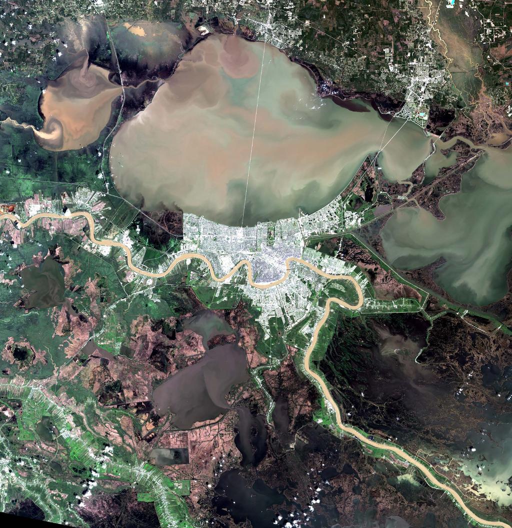

4 Landsat-8, March 13, 2016


, 2011 (94%), 2016")
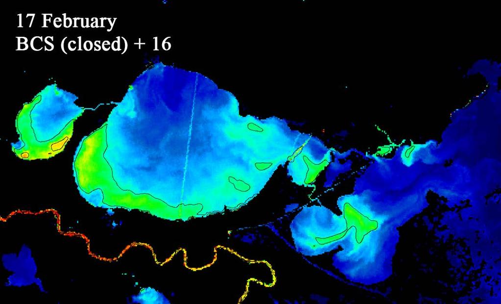
5 Spillways & Diversions Bonnet Carré Spillway 5.7 mi spillway by 7-12k feet wide Flows into Lake Pontchartrain 2008 (46% of 350 bays), 2011 (94%), 2016 (60%) 1929 construction


6 Spillways & Diversions Davis Pond Freshwater Diversion Completed in 2002 Largest of the FDs in Louisiana Combat salt water intrusion Promote healthy environment for seafood industry 10,000 acres Max flow > cfs Combat land loss

7


8 Study Area Lake Cataouache Lake Salvador Bayou Rigolettes Little Lake Bay Dosgris Barataria Bay
9 Study Summary Locate clear-sky MODIS imagery for dates of field data Perform atmospheric correction Develop regression model correlating reflectance to sediment concentration Challenges : Solutions Unfortunately, field work not planned around use of satellite imagery! Difficulty utilizing NASA algorithms on small inland waters : Employ clear-water pixel algorithm on Rayliegh-corrected reflectance Spatial Resolution : Utilized 645nm (red) channel for 250m resolution Fixed stations proximal to shoreline where stray light contaminates imagery : Ultimately rejected altogether Apply model to scenarios combining diversion discharge and wind conditions Extract data over water pixels in provided polygons for simple statistics
10 Methodology & Tools Utilize SeaDAS for image processing/analysis Derive Rayleigh-corrected reflectance (rhos) Leverage powerful masking capabilities of SeaDAS Easy band math for clear-water pixel subtraction Miscellaneous post-processing in Python

11 SSC = 20,180(R645) (R645) R-Sq = 0.84 n = 108 RMSE = mg/l

12 Results May 10, 2010 High discharge from DPFD Light wind regime High sediment also seen from Caernarvon Diversion on east side of Miss. River

13 Results March 27, 2015 Pulse from DPFD Immediately following southerly wind regime


14 Results Jan 27, 2010 Easterly wind regime Note sediment from Miss. River approaching from the east


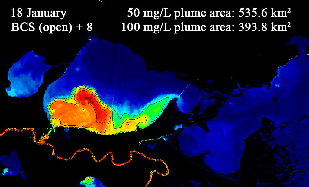
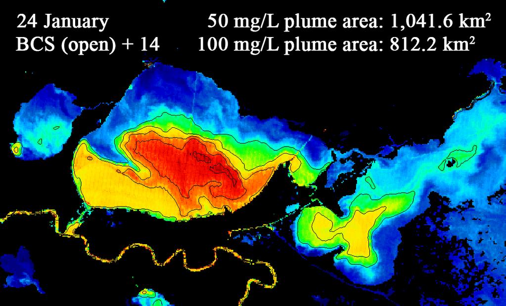
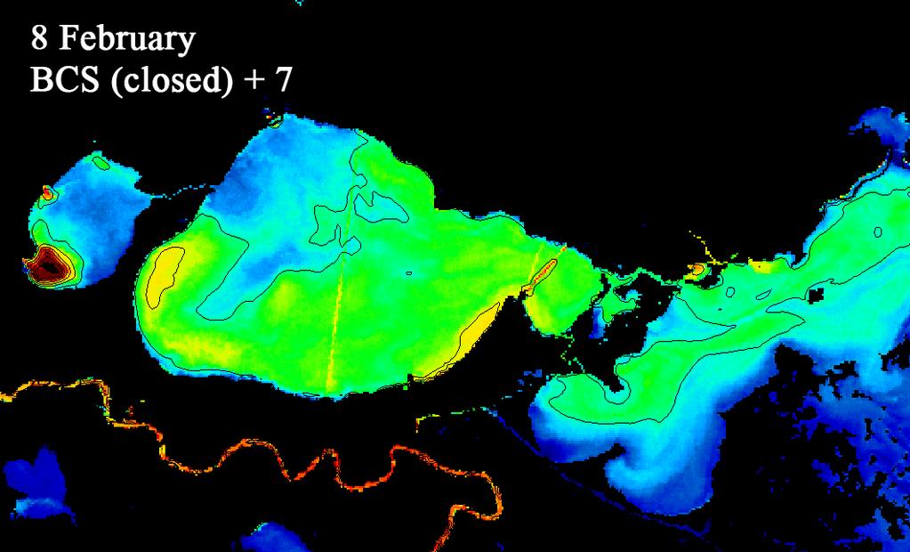
15 Extending to Lake Pontchartrain Rare opportunity: Bonnet Carré Spillway opening MS thesis work of Robert Iles Aqua MODIS, 18:19 UTC, January 18, 2016

16 Extending to Lake Pontchartrain ISC = e x R-Sq: 0.97 RMSE: mg/l
17
18
19 Conclusions Use of MODIS satellite imagery to hindcast sediment distribution and behavior proved useful, if challenging Regression models successfully developed Winds seem to play a large role in of sediment behavior Field data collection: Fun (?) but burdensome Obvious need to coordinate with satellite schedules Need more in situ sensors, away from shorelines for better atmospheric correction Provide information for the planning of future diversions Can inform sediment behavior during future spillway openings Strengthen models through further study
20 Acknowledgements Thank you! Thanks also to: The Water Institute of the Gulf PIs: Cyndhia Ramatchandirane, Mead Allison LSU Coastal Studies Institute Ishan Joshi (SeaDAS bootstrap!)
21 Questions?
Applications of High Frequency Geostationary Satellite Data in Hurricane Surveillance and Research
 Applications of High Frequency Geostationary Satellite Data in Hurricane Surveillance and Research by Nan Walker Director, Earth Scan Laboratory Coastal Studies Institute Associate Professor, Dept. of
Mapping the River as it Reconnects with Its Delta: Field Studies in Big Mar and Bohemia
 Mapping the River as it Reconnects with Its Delta: Field Studies in Big Mar and Bohemia Ezra Boyd, John Lopez, Andy Baker, Theryn Henkel Lake Pontchartrain Basin Foundation Coastal Sustainability Program
Forecasting Gulf of Mexico Hypoxia under Scenarios of Watershed and River Management
 Forecasting Gulf of Mexico Hypoxia under Scenarios of Watershed and River Management Dubravko Justic and Lixia Wang Department of Oceanography and Coastal Sciences College of the Coast and Environment
THE USE OF AIRCRAFT-BORNE MAS DATA FOR MAPPING SEDIMENT TRANSPORT ALONG THE LOUISIANA COAST* 1225 West Dayton Street Madison, WI
 THE USE OF AIRCRAFT-BORNE MAS DATA FOR MAPPING SEDIMENT TRANSPORT ALONG THE LOUISIANA COAST* Christopher C. Moeller 1, Oscar K. Huh 2, W. Paul Menzel 3, Harry H. Roberts 2 1 Cooperative Institute for Meteorological
P1.16 RECENT MONITORING OF SUSPENDED SEDIMENT PATTERNS ALONG LOUISIANA S COASTAL ZONE USING ER-2 BASED MAS DATA AND TERRA BASED MODIS DATA.
 P1.16 RECENT MONITORING OF SUSPENDED SEDIMENT PATTERNS ALONG LOUISIANA S COASTAL ZONE USING ER-2 BASED MAS DATA AND TERRA BASED MODIS DATA. Christopher C. Moeller* 1, M. M. Gunshor 1, W. P. Menzel 2, O.K.
KEY CONTROLS ON SEDIMENT BUDGETING IN THE MISSISSIPPI RIVER FROM SOURCE TO SINK
 KEY CONTROLS ON SEDIMENT BUDGETING IN THE MISSISSIPPI RIVER FROM SOURCE TO SINK Mead Allison The Water Institute of the Gulf & Tulane University What Controls the Availability of Sediment in the Restoration
Optimal Design of Sediment Diversions for Delta Restoration: lessons learned from examples
 Optimal Design of Sediment Diversions for Delta Restoration: lessons learned from examples Samuel Bentley 1, Angelina Freeman 2, Clinton S. Willson 1, Liviu Giosan 3, Jaye Cable 4 1 LSU 2 EDF 3 WHOI 4
Undergraduate Research Final Report: Estimation of suspended sediments using MODIS 250 m bands in Mayagüez Bay, Puerto Rico
 Undergraduate Research Final Report: Estimation of suspended sediments using MODIS 250 m bands in Mayagüez Bay, Puerto Rico Abstract: José F. Martínez Colón Undergraduate Research 2007 802-03-4097 Advisor:
THE IMPORTANCE OF SCIENCE IN COASTAL RESTORATION IN LOUISIANA
 THE IMPORTANCE OF SCIENCE IN COASTAL RESTORATION IN LOUISIANA Barb Kleiss USACE, Mississippi Valley Division August 3, 2011 LCA S&T Office Authorized under WRDA 2007 Designed to address technical issues
Estimation of ocean contribution at the MODIS near-infrared wavelengths along the east coast of the U.S.: Two case studies
 GEOPHYSICAL RESEARCH LETTERS, VOL. 32, L13606, doi:10.1029/2005gl022917, 2005 Estimation of ocean contribution at the MODIS near-infrared wavelengths along the east coast of the U.S.: Two case studies
JORDAN VICK PINO. Dissertation: Modeling the effects of winter storms on power infrastructure systems in the northern United States
 JORDAN VICK PINO Department of Geography The Ohio State University 154 North Oval Mall, 1145 Derby Hall Columbus, OH 43210-1342 pino.17@osu.edu https://geography.osu.edu/people/pino.17 EDUCATION Ph.D.,
The Delaware Environmental Monitoring & Analysis Center
 The Delaware Environmental Monitoring & Analysis Center Tina Callahan Delaware Estuary Science & Environmental Summit 2013 January 27-30, 2013 What is DEMAC? Delaware Environmental Monitoring & Analysis
Impact & Recovery of Wetland Plant Communities after the Gulf Oil Spill in 2010 and Hurricane Isaac in 2012
 Impact & Recovery of Wetland Plant Communities after the Gulf Oil Spill in 2010 and Hurricane Isaac in 2012 Introduction: The coastal wetlands, estuaries and lagoon systems of the Gulf Coast are a hotspot
NESDIS Polar (Region) Products and Plans. Jeff Key NOAA/NESDIS Madison, Wisconsin USA
 Products and Plans. Jeff Key NOAA/NESDIS Madison, Wisconsin USA") NESDIS Polar (Region) Products and Plans Jeff Key NOAA/NESDIS Madison, Wisconsin USA WMO Polar Space Task Group, 2 nd meeting, Geneva, 12 14 June 2012 Relevant Missions and Products GOES R ABI Fractional
NESDIS Polar (Region) Products and Plans Jeff Key NOAA/NESDIS Madison, Wisconsin USA WMO Polar Space Task Group, 2 nd meeting, Geneva, 12 14 June 2012 Relevant Missions and Products GOES R ABI Fractional
Satellite-based Lake Surface Temperature (LST) Homa Kheyrollah Pour Claude Duguay
 Homa Kheyrollah Pour Claude Duguay") Satellite-based Lake Surface Temperature (LST) Homa Kheyrollah Pour Claude Duguay Lakes in NWP models Interaction of the atmosphere and underlying layer is the most important issue in climate modeling
Satellite-based Lake Surface Temperature (LST) Homa Kheyrollah Pour Claude Duguay Lakes in NWP models Interaction of the atmosphere and underlying layer is the most important issue in climate modeling
Extending the Deep Blue aerosol record from SeaWiFS and MODIS to NPP-VIIRS
 Extending the Deep Blue aerosol record from SeaWiFS and MODIS to NPP-VIIRS Andrew M. Sayer, N. Christina Hsu (PI), Corey Bettenhausen, Jaehwa Lee Climate & Radiation Laboratory, NASA Goddard Space Flight
Automated ocean color product validation for the Southern California Bight
 Automated ocean color product validation for the Southern California Bight Curtiss O. Davis a, Nicholas Tufillaro a, Burt Jones b, and Robert Arnone c a College of Earth, Ocean and Atmospheric Sciences,
Reducing Nitrogen Removal Uncertainty for Operation of Mississippi River Sediment Diversions: Nitrate Reduction Rates In Turbulent Flow Conditions
 Reducing Nitrogen Removal Uncertainty for Operation of Mississippi River Sediment Diversions: Nitrate Reduction Rates In Turbulent Flow Conditions Nia R. Hurst, John R. White, Kehui Xu, and MingCheng Ren
Monitoring Hurricane Rita Inland Storm Surge
 Monitoring Hurricane Rita Inland Storm Surge By Benton D. McGee, Roland W. Tollett, and Burl B. Goree Pressure transducers (sensors) are accurate, reliable, and cost-effective tools to measure and record
An Integrated Storm Surge, Hurricane Wave, Salinity and Sediment Transport Modeling System for Breton Sound, LA
 An Integrated Storm Surge, Hurricane Wave, Salinity and Sediment Transport Modeling System for Breton Sound, LA Q. Jim Chen Department of Civil and Environmental Engineering qchen@lsu.edu Acknowledgements
Title. Author(s)Radiarta, I Nyoman; Saitoh, Sei-Ichi. Issue Date Doc URL. Type. Note. File Information
Radiarta, I Nyoman; Saitoh, Sei-Ichi. Issue Date Doc URL. Type. Note. File Information") Title Spatial information systems approach toward sustaina Author(s)Radiarta, I Nyoman; Saitoh, Sei-Ichi International Symposium on "Sustainability Science o Citation2009. Hakodate, Japan. Issue Date 2009-11-07
Title Spatial information systems approach toward sustaina Author(s)Radiarta, I Nyoman; Saitoh, Sei-Ichi International Symposium on "Sustainability Science o Citation2009. Hakodate, Japan. Issue Date 2009-11-07
Greening of Arctic: Knowledge and Uncertainties
 Greening of Arctic: Knowledge and Uncertainties Jiong Jia, Hesong Wang Chinese Academy of Science jiong@tea.ac.cn Howie Epstein Skip Walker Moscow, January 28, 2008 Global Warming and Its Impact IMPACTS
Interpretation of Polar-orbiting Satellite Observations. Atmospheric Instrumentation
 Interpretation of Polar-orbiting Satellite Observations Outline Polar-Orbiting Observations: Review of Polar-Orbiting Satellite Systems Overview of Currently Active Satellites / Sensors Overview of Sensor
DRARS Coordination Meeting Contribution from IMD
 DRARS Coordination Meeting Contribution from IMD Dr. Ashim Kumar Mitra Ministry of Earth Sciences India Meteorological Department New Delhi-INDIA 11-13 March 2015 The Processing System of NOAA/METOP/MODIS
Earth Wind & Fire. Game Changing Restoration Options in the Texas Chenier Plain
 Earth Wind & Fire Game Changing Restoration Options in the Texas Chenier Plain EARTH: The Chenier Plain is a 5 million acre coastal region in Southwest Louisiana and Southeast Texas providing landscape
Direct Readout at the Meteorological Service of Canada
 Direct Readout at the Meteorological Service of Canada CSPP Users Meeting 2015 Darmstadt, Germany April 14-16, 2015 David Bradley Manager, Earth Observation and Geomatics Meteorological Service of Canada
Smooth Cordgrass Varieties. Description and Performance
 Smooth Cordgrass Varieties Description and Performance Smooth cordgrass (Spartina alterniflora Loisel.) is a perennial grass native to intertidal saline marshes along the Gulf of Mexico and Atlantic coasts.
New NASA Ocean Observations and Coastal Applications
 New NASA Ocean Observations and Coastal Applications Duane Armstrong Chief, Applied Science & Technology Project Office August 20, 2014 1 Outline NASA s new Earth Science Ocean Science Missions for 2014
Descriptions and Performance
 LSU AgCenter Coastal Plants Program Smooth Cordgrass Varieties: Descriptions and Performance Smooth cordgrass (Spartina alterniflora Loisel.) is a perennial grass native to intertidal saline marshes along
Some NOAA Products that Address PSTG Satellite Observing Requirements. Jeff Key NOAA/NESDIS Madison, Wisconsin USA
 Some NOAA Products that Address PSTG Satellite Observing Requirements Jeff Key NOAA/NESDIS Madison, Wisconsin USA WMO Polar Space Task Group, 4 th meeting, Greenbelt, 30 September 2014 Relevant Missions
NOAA Great Lakes CoastWatch Program
 Great Lakes Workshop Series on Remote Sensing of Water Quality May 7-8, 2014 NOAA GLERL, 4840 South State Rd, Ann Arbor, MI NOAA Great Lakes CoastWatch Program CoastWatch is a nationwide National Oceanic
Cross-calibration of Geostationary Satellite Visible-channel Imagers Using the Moon as a Common Reference
 Cross-calibration of Geostationary Satellite Visible-channel Imagers Using the Moon as a Common Reference Thomas C. Stone U.S. Geological Survey, Flagstaff AZ, USA 27 30 August, 2012 Motivation The archives
Hindcasting Wave Conditions on the North American Great Lakes
 Hindcasting Wave Conditions on the North American Great Lakes D. Scott 1, D. Schwab 2, C. Padala 1, and P. Zusek 1 1. & Associates 2. Great Lakes Environmental Research Laboratory, NOAA Lake Ontario 310
Joint Polar Satellite System. 3 rd Post-EPS User Consultation Workshop Mike Haas
 3 rd Post-EPS User Consultation Workshop Mike Haas Overview Introduction - Policy Drivers - Management System Description - Space Segment - Ground Segment Partnerships Status Benefits 2 Introduction (Policy
The Pontchartrain Maurepas Surge Consortium (LPMSC) Lake Sloshing Effect Preliminary Findings
 Lake Sloshing Effect Preliminary Findings") The Pontchartrain Maurepas Surge Consortium (LPMSC) Lake Sloshing Effect Preliminary Findings Lake Pontchartrain Basin Foundation John A. Lopez, Ph.D. with contributions from Dr. Joe Suhayda, Dr. Hal Needham,
The Pontchartrain Maurepas Surge Consortium (LPMSC) Lake Sloshing Effect Preliminary Findings Lake Pontchartrain Basin Foundation John A. Lopez, Ph.D. with contributions from Dr. Joe Suhayda, Dr. Hal Needham,
Monitoring Coastal Marshes for Persistent Saltwater Intrusion
 Monitoring Coastal Marshes for Persistent Saltwater Intrusion Maria Kalcic, 1 Callie Hall, 2 Jeff Russell, 3 and Rose Fletcher 1 1 Science Systems and Applications, Inc., Bldg. 1105, John C. Stennis Space
Monitoring Sea Surface temperature change at the Caribbean Sea, using AVHRR images. Y. Santiago Pérez, and R. Mendez Yulfo
 Monitoring Sea Surface temperature change at the Caribbean Sea, using AVHRR images. Y. Santiago Pérez, and R. Mendez Yulfo Department of Geology, University of Puerto Rico Mayagüez Campus, P.O. Box 9017,
River Model (Delft3D)
") A Short River Model (Delft3D) & DIVERSION ANALYSIS presented by Nina J. Reins, PE, PhD, PMP State of the Coast May 30-June 1, 2018 Overview of Presentation Problem Statement & Background Analysis Key Findings
A Short River Model (Delft3D) & DIVERSION ANALYSIS presented by Nina J. Reins, PE, PhD, PMP State of the Coast May 30-June 1, 2018 Overview of Presentation Problem Statement & Background Analysis Key Findings
Measurements of lateral flow from the Mississippi River at Mardi Gras Pass in the Bohemia Spillway using synoptic ADCP
 Measurements of lateral flow from the Mississippi River at Mardi Gras Pass in the Bohemia Spillway using synoptic ADCP A Technical Report Submitted to: The Lake Pontchartrain Basin Foundation Submitted
Wetland attenuation of Hurricane Rita s storm surge
 Wetland attenuation of Hurricane Rita s storm surge Pat Fitzpatrick, Yee Lau, Yongzuo Li, Nam Tran, Chris Hill, and Suzanne Shean Geosystems Research Institute, Mississippi State University Sponsors: NOAA
Annex VI-1. Draft National Report on Ocean Remote Sensing in China. (Reviewed by the Second Meeting of NOWPAP WG4)
") UNEP/NOWPAP/CEARAC/WG4 2/9 Page1 Draft National Report on Ocean Remote Sensing in China (Reviewed by the Second Meeting of NOWPAP WG4) UNEP/NOWPAP/CEARAC/WG4 2/9 Page1 1. Status of RS utilization in marine
UNEP/NOWPAP/CEARAC/WG4 2/9 Page1 Draft National Report on Ocean Remote Sensing in China (Reviewed by the Second Meeting of NOWPAP WG4) UNEP/NOWPAP/CEARAC/WG4 2/9 Page1 1. Status of RS utilization in marine
Influence of the Major Drainages to the Mississippi River and Implications for System Level Management
 Influence of the Major Drainages to the Mississippi River and Implications for System Level Management Brian M. Vosburg Geologist Louisiana Coastal Protection and Restoration Authority brian.vosburg@la.gov
Visualizing Upper Trophic and Ecosystem Modeling Outputs with EverVIEW to Inform the Decision Process in Coastal Louisiana.
 Visualizing Upper Trophic and Ecosystem Modeling Outputs with EverVIEW to Inform the Decision Process in Coastal Louisiana 2012 Master Plan Craig Conzelmann Carol Parsons Richards Kevin Suir COMPREHENSIVE
DERIVING ATMOSPHERIC MOTION VECTORS FROM AIRS MOISTURE RETRIEVAL DATA
 DERIVING ATMOSPHERIC MOTION VECTORS FROM AIRS MOISTURE RETRIEVAL DATA David Santek 1, Sharon Nebuda 1, Christopher Velden 1, Jeff Key 2, Dave Stettner 1 1 Cooperative Institute for Meteorological Satellite
Outcome of the GSICS/CEOS-IVOS Lunar Calibration Workshop
 Outcome of the GSICS/CEOS-IVOS Lunar Calibration Workshop S. Wagner a, T. Hewison a, T. Stone b, S. Lachérade c, B. Fougnie c, X. Xiong d With the support of M. Takahashi JMA (1-year visiting scientist
Bldg., Corvallis, OR, USA USA 39529, USA. Arabia 1. INTRODUCTION ABSTRACT
 Evaluating VIIRS Ocean Color Products for West Coast and Hawaiian Waters Curtiss O. Davis a, Nicholas Tufillaro a, Jasmine Nahorniak a, Burton Jones b,d and Robert Arnone c a College of Earth, Ocean and
MISSISSIPPI RIVER DELTA OVERVIEW
 MISSISSIPPI RIVER DELTA OVERVIEW Science and Engineering Special Team Conference Louisiana State University October 9, 2012 Introduction Basics of the Mississippi Delta Natural and Human-Induced Land Loss
Improving Numerical Weather Forecasting for Ghana/West Africa
 Improving Numerical Weather Forecasting for Ghana/West Africa Amos T. Kabo-bah, PhD Head, Earth Observation Research and Innovation Centre University of Energy and Natural Resources Sunyani Ghana/West
FUTURE PLAN AND RECENT ACTIVITIES FOR THE JAPANESE FOLLOW-ON GEOSTATIONARY METEOROLOGICAL SATELLITE HIMAWARI-8/9
 FUTURE PLAN AND RECENT ACTIVITIES FOR THE JAPANESE FOLLOW-ON GEOSTATIONARY METEOROLOGICAL SATELLITE HIMAWARI-8/9 Toshiyuki Kurino Japan Meteorological Agency, 1-3-4 Otemachi Chiyodaku, Tokyo 100-8122,
Observing System Requirements for the Harmful Algal Bloom Forecast System in the Gulf of Mexico
 Observing System Requirements for the Harmful Algal Bloom Forecast System in the Gulf of Mexico July 2007 Background The Harmful Algal Bloom (HAB) Forecast System provides nowcasts and forecasts of Karenia
Status of VIIRS Reflective Solar Bands On-orbit Calibration and Performance
 EOS Status of VIIRS Reflective Solar Bands On-orbit Calibration and Performance X. Xiong 1, J. Fulbright 2, N. Lei 2, J. Sun 2, Z. Wang 2, and J. McIntire 2 1. NASA/GSFC, Greenbelt, MD 20771, USA 2. Sigma
SATELLITE DATA COLLECTION BY THE UPRM-TCESS SPACE INFORMATION LABORATORY
 SATELLITE DATA COLLECTION BY THE UPRM-TCESS SPACE INFORMATION LABORATORY Visita a la Estación De Satélites De UPRM En el CID 16 sep. 4:30 pm Nos reuniremos al frente del CID. CID L-BAND ANTENNA Orbview
Introduction: The Gulf of Mexico Alliance. The Gulf GAME project MERMAid and PHINS Results & Conclusions What s next? Examples
 AAG Las Vegas March 25, 2009 Introduction: Ocean governance and Ecosystem-Based Management The Gulf of Mexico Alliance Habitat Identification and Characterization The Gulf GAME project MERMAid and PHINS
NOAA Observing System Integrated Analysis (NOSIA) Applications
 Applications") NOAA Observing System Integrated Analysis (NOSIA) Applications Aaron Pratt 1,2, PhD, David Helms 2, Louis Cantrell 2,4, PhD, Vincent Ries 4 1 Science and Technology Corporation 2 NOAA/NESDIS/OSD/TPIO 3
NOAA Observing System Integrated Analysis (NOSIA) Applications Aaron Pratt 1,2, PhD, David Helms 2, Louis Cantrell 2,4, PhD, Vincent Ries 4 1 Science and Technology Corporation 2 NOAA/NESDIS/OSD/TPIO 3
EROSIONAL RATES IN THE POINT AUX CHENES BAY AREA, MISSISSIPPI: Kathleen P. Wacker G. Alan Criss INTRODUCTION
 Summary of a Paper Presented at the: Sixtieth Annual Meeting of the Mississippi Academy of Sciences in Jackson, Mississippi February 22, 1996 ===============================================================
Vicarious calibration of GLI by global datasets. Calibration 5th Group Hiroshi Murakami (JAXA EORC)
") Vicarious calibration of GLI by global datasets Calibration 5th Group Hiroshi Murakami (JAXA EORC) ADEOS-2 PI workshop March 2004 1 0. Contents 1. Background 2. Operation flow 3. Results 4. Temporal change
Vicarious calibration of GLI by global datasets Calibration 5th Group Hiroshi Murakami (JAXA EORC) ADEOS-2 PI workshop March 2004 1 0. Contents 1. Background 2. Operation flow 3. Results 4. Temporal change
PLEASE SCROLL DOWN FOR ARTICLE. Full terms and conditions of use:
 This article was downloaded by: [Naval Research Laboratory] On: 19 January 2011 Access details: Access Details: [subscription number 915935636] Publisher Taylor & Francis Informa Ltd Registered in England
Interannual variation of MODIS NDVI in Lake Taihu and its relation to climate in submerged macrophyte region
 Yale-NUIST Center on Atmospheric Environment Interannual variation of MODIS NDVI in Lake Taihu and its relation to climate in submerged macrophyte region ZhangZhen 2015.07.10 1 Outline Introduction Data
GEOSC/METEO 597K Kevin Bowley Kaitlin Walsh
 GEOSC/METEO 597K Kevin Bowley Kaitlin Walsh Timeline of Satellites ERS-1 (1991-2000) NSCAT (1996) Envisat (2002) RADARSAT (2007) Seasat (1978) TOPEX/Poseidon (1992-2005) QuikSCAT (1999) Jason-2 (2008)
PROPOSED UNESCO FUNDY BIOSPHERE RESERVE
 OVERVIEW PROPOSED UNESCO FUNDY BIOSPHERE RESERVE NEW BRUNSWICK, CANADA NOMINATION DOCUMENT April 10, 2007 The United Nations Educational, Scientific and Cultural Organization (UNESCO) Man and the Biosphere
THE ROLE PLAYED BY BLOCKING OVER THE NORTHERN HEMISPHERE ON HURRICANE KATRINA
 THE ROLE PLAYED BY BLOCKING OVER THE NORTHERN J P 3.51 HEMISPHERE ON HURRICANE KATRINA Yehia Hafez* University of Cairo, Giza, Egypt ABSTARCT On year 2005, there exist 28 tropical Atlantic storms and hurricanes
Eco-hydromorphic Characterization of the Louisiana Coastal Region Using Multiple Remotely Sensed Data Sources and Analyses
 National Wetlands Research Center Eco-hydromorphic Characterization of the Louisiana Coastal Region Using Multiple Remotely Sensed Data Sources and Analyses 1Holly Beck, 2 Brady Couvillion, 1 Nadine Trahan
Talk Overview. Concepts. Climatology. Monitoring. Applications
 Atmospheric Rivers Talk Overview Concepts Climatology Monitoring Applications Satellite View Where is the storm? Where is the impact? Atmospheric Rivers Plume or fire hose of tropical moisture Heavy precipitation
Satellite-derived Wind, Cloud, and Surface Products at Direct Broadcast Sites in the Antarctic and Arctic
 Satellite-derived Wind, Cloud, and Surface Products at Direct Broadcast Sites in the Antarctic and Arctic William Straka III +, Jeff Key*, Dave Santek +, Matthew Lazzara #, Liam Gumley +, Kathy Strabala
Integrating new coastline information and geographically coordinated coastal geomorphology data
 Integrating new coastline information and geographically coordinated coastal geomorphology data NOAA Contemporary Shoreline DOE Coastal Geomorphology Cynthia Miller Corbett Jeff Simley 1 National Hydrography
Sediment Deposition LET THE RIVER RUN T E A C H E R. Activity Overview. Activity at a Glance. Time Required. Level of Complexity.
 Activity at a Glance Grade: 6 9 Subject: Science Category: Physical Science, Earth Science Topic: Deposition, River Systems Time Required Two 45-minute periods Level of Complexity Medium Materials* TI-73
HURRICANE NATE BRIEFING
 HURRICANE NATE BRIEFING 2:00 PM CDT Saturday, October 07, 2017 Prepared by: NWS NWSNewOrleans www.weather.gov/neworleans Situation Overview continues to intensify. It is now forecast to be a category 2
GOES-R. Getting ready for the next generation earth observing system. Yuguang He AER April 10, 2015
 GOES-R Getting ready for the next generation earth observing system Yuguang He AER April 10, 2015 Outline! AER in research and applica0ons! AER on GOES- R! GOES- R: the next genera0on! Ge:ng ready for
Impacts of Atmospheric Corrections on Algal Bloom Detection Techniques
 1 Impacts of Atmospheric Corrections on Algal Bloom Detection Techniques Ruhul Amin, Alex Gilerson, Jing Zhou, Barry Gross, Fred Moshary and Sam Ahmed Optical Remote Sensing Laboratory, the City College
TEMPO Aerosols. Need for TEMPO-ABI Synergy
 TEMPO Aerosols Need for TEMPO-ABI Synergy Omar Torres, Hiren Jethva, Changwoo Ahn CEOS - 2018 NOAA-College Park May 04, 2018 Use of near UV Satellite Observations for retrieving aerosol properties over
5.5. Coastal and inland waters
 5.5. Coastal and inland waters 5. Atmospheric Correction SeaWiFS and MODIS Experiences Show: High quality ocean color products for the global open oceans (Case-1 waters). Significant efforts are needed
Comparative Analysis of Hurricane Vulnerability in New Orleans and Baton Rouge. Dr. Marc Levitan LSU Hurricane Center. April 2003
 Comparative Analysis of Hurricane Vulnerability in New Orleans and Baton Rouge Dr. Marc Levitan LSU Hurricane Center April 2003 In order to compare hurricane vulnerability of facilities located in different
Harmful Algal Bloom Detectives in the Gulf of Mexico Satellites, Gliders and Buoys, Oh My!
 Harmful Algal Bloom Detectives in the Gulf of Mexico Satellites, Gliders and Buoys, Oh My! By Chris Simoniello and Ruth Mullins* With information from: *The Gulf of Mexico Coastal Ocean Observing System
AMVs in the operational ECMWF system
 AMVs in the operational ECMWF system Kirsti Salonen and Niels Bormann Slide 1 AMV sample coverage: monitored GOES-15 GOES-13 MET-10 MET-7 MTSAT-2 NOAA-15 NOAA-18 NOAA-19 FY-2D FY-2E AQUA TERRA METOP-A
Altimetry for Coastal Applications. Paul M. DiGiacomo and Amanda Bittinger NOAA CoastWatchatch Program 5 February 2008
 Altimetry for Coastal Applications Paul M. DiGiacomo and Amanda Bittinger NOAA CoastWatchatch Program 5 February 2008 IGOS COASTAL THEME REPORT Published January 2006, IOC http://www.igospartners.org/d
Report on the Damage Survey Caused by Hurricane Katrina (Tentative Report)
") Report on the Damage Survey Caused by Hurricane Katrina (Tentative Report) November 1, 2005 Coastal Disaster Prevention Technology Survey Team 1. Introduction Hurricane Katrina struck the United States
Report on the Damage Survey Caused by Hurricane Katrina (Tentative Report) November 1, 2005 Coastal Disaster Prevention Technology Survey Team 1. Introduction Hurricane Katrina struck the United States
Forecast of Nearshore Wave Parameters Using MIKE-21 Spectral Wave Model
 Forecast of Nearshore Wave Parameters Using MIKE-21 Spectral Wave Model Felix Jose 1 and Gregory W. Stone 2 1 Coastal Studies Institute, Louisiana State University, Baton Rouge, LA 70803 2 Coastal Studies
PRESS RELEASE LOUISIANA UNIVERSITIES MARINE CONSORTIUM July 31, 2011
 PRESS RELEASE LOUISIANA UNIVERSITIES MARINE CONSORTIUM July 31, 2011 Scientists have returned from mapping the 2011 area of hypoxia, commonly known as the Dead Zone, along the Louisiana coast. This year
McIDAS support of Suomi-NPP /JPSS and GOES-R L2
 McIDAS support of Suomi-NPP /JPSS and GOES-R L2 William Straka III 1 Tommy Jasmin 1, Bob Carp 1 1 Cooperative Institute for Meteorological Satellite Studies, Space Science and Engineering Center, University
An analysis of storm surge attenuation by wetlands using USGS, FEMA, and NASA data
 An analysis of storm surge attenuation by wetlands using USGS, FEMA, and NASA data Pat Fitzpatrick Geosystems Research Institute Mississippi State University Walter Peterson and Courtney Buckley NASA Marshall
Hypoxia in the Northern Gulf of Mexico in 2010: was the Deepwater Horizon Oil Spill a Factor? Nathaniel E. Ostrom
 Agricultural Outlook Forum Presented: February 24-25, 2011 U.S. Department of Agriculture Hypoxia in the Northern Gulf of Mexico in 2010: was the Deepwater Horizon Oil Spill a Factor? Nathaniel E. Ostrom
Arctic-Coastal Land Ocean Interactions
 Arctic- Project PIs: Maria Tzortziou (CCNY / CUNY) Antonio Mannino (NASA/GSFC) Joseph Salisbury (Univ. of NH) Peter Hernes (UC Davis) Carlos Del Castillo (NASA/GSFC) Marjorie Friedrichs (VIMS) Patricia
MONITORING WEATHER AND CLIMATE FROM SPACE
 MONITORING WEATHER AND CLIMATE FROM SPACE EUMETSAT Report on New Services Anders Meier Soerensen New X/L-band antenna, Greenland Athens: New 3.0 m L/X-band antenna New 2.4 m L/Xband antenna Installations
An Algorithm for Retrieving Land Surface Temperatures Using VIIRS Data in Combination with Multi-Sensors
 Sensors 2014, 14, 21385-21408; doi:10.3390/s141121385 Article OPEN ACCESS sensors ISSN 1424-8220 www.mdpi.com/journal/sensors An Algorithm for Retrieving Land Surface Temperatures Using VIIRS Data in Combination
The use of Direct Broadcast Processing System in Poland
 The use of Direct Broadcast Processing System in Poland B.Łapeta, P.Struzik Satellite Remote Sensing Department, Institute of Meteortology and Water Management National Reasearch Institute About IMWM-NRI
NOAA Surface Weather Program
 NOAA Surface Weather Program Maintenance Decision Support System Stakeholder Meeting #9 Jim O Sullivan NOAA Surface Weather Program Manager NWS Office of Climate, Water, and Weather Services September
Global Ecosystem Mapping For UN SEEA Ecosystem Accounting
 Global Ecosystem Mapping For UN SEEA Ecosystem Accounting Roger Sayre (U. S. Geological Survey); Dawn Wright, Sean Breyer, Charlie Frye, and others (Esri) UN SEEA Experts Forum on Ocean Ecosystem Accounting
VIIRS SDR Cal/Val: S-NPP Update and JPSS-1 Preparations
 VIIRS SDR Cal/Val: S-NPP Update and JPSS-1 Preparations VIIRS SDR Cal/Val Posters: Xi Shao Zhuo Wang Slawomir Blonski ESSIC/CICS, University of Maryland, College Park NOAA/NESDIS/STAR Affiliate Spectral
Remote Sensing of Chlorophyll-a in Texas Estuaries. Claire G. Griffin. CE 394K.3 GIS in Water Resources Fall Introduction
 Remote Sensing of Chlorophyll-a in Texas Estuaries Claire G. Griffin CE 394K.3 GIS in Water Resources Fall 2010 Introduction Coastal and estuarine primary productivity, as indicated by chlorophyll concentrations,
Hydrologic Analysis for Ecosystem Restoration
 Hydrologic Analysis for Ecosystem Restoration Davis, California Objectives: To provide participants with: 1) an understanding of the issues in restoration studies; 2) an overview of Corps policies and
GMES: calibration of remote sensing datasets
 GMES: calibration of remote sensing datasets Jeremy Morley Dept. Geomatic Engineering jmorley@ge.ucl.ac.uk December 2006 Outline Role of calibration & validation in remote sensing Types of calibration
Meteorological Service of Canada Perspectives. WMO Coordination Group on Satellite Data Requirements for RAIII/IV
 Meteorological Service of Canada Perspectives presented to the WMO Coordination Group on Satellite Data Requirements for RAIII/IV David Bradley Meteorological Service of Canada Environment Canada April
HICO OSU Website and Data Products
 HICO OSU Website and Data Products Curtiss O. Davis College of Earth Ocean and Atmospheric Sciences Oregon State University, Corvallis, OR, USA 97331 cdavis@coas.oregonstate.edu Oregon State Introduction
The NASA Short-term Prediction Research and Transition (SPoRT) Center:
 Center:") The NASA Short-term Prediction Research and Transition (SPoRT) Center: Opportunities for Collaboration in the Great Lakes Region Andrew Molthan NASA Marshall Space Flight Center, Huntsville, AL andrew.molthan@nasa.gov
The NASA Short-term Prediction Research and Transition (SPoRT) Center: Opportunities for Collaboration in the Great Lakes Region Andrew Molthan NASA Marshall Space Flight Center, Huntsville, AL andrew.molthan@nasa.gov
The Future of NOAA Satellite Systems and Data
 The Future of NOAA Satellite Systems and Data -- H.R. 353 Weather Research & Forecasting Innovation Act of 2017 Committee on Earth Science & Applications from Space (CESAS) Washington, DC March 28, 2017
Southern Florida to Cape Hatteras Spring Season Preview 2018 UPDATE ON U.S. EAST COAST GULF STREAM CONDITIONS
 Southern Florida to Cape Hatteras Spring Season Preview 2018 UPDATE ON U.S. EAST COAST GULF STREAM CONDITIONS By ROFFS Gregory J. Gawlikowski ROFFS continues its spring preview series by providing an overall
Framework for the Basin-Wide Socio-Economic Analysis of Four Proposed Sediment Diversions. August 4, 2015
 Framework for the Basin-Wide Socio-Economic Analysis of Four Proposed Sediment Diversions August 4, 2015 Proposed Sediment Diversions Mid-Breton Mid-Barataria Lower Barataria Lower Breton Overview of Presentation
Advancing Environmental Intelligence via Next-Generation Satellite Observations
 Advancing Environmental Intelligence via Next-Generation Satellite Observations Steven D. Miller Cooperative Institute for Research in the Atmosphere 11 th NOAA/NESDIS CoRP Science Symposium 16 September
Overview. Gulf of Mexico Alliance Ocean and Coastal Mapping Regional Ecosystem Data Management (REDM) Q2O (QARTOD to OGC) Things to Consider
 Q2O (QARTOD to OGC) Things to Consider") 1 Overview Gulf of Mexico Alliance Ocean and Coastal Mapping Regional Ecosystem Data Management (REDM) Q2O (QARTOD to OGC) Things to Consider 2 Gulf Of Mexico Alliance Partnership of the states of Alabama,
1 Overview Gulf of Mexico Alliance Ocean and Coastal Mapping Regional Ecosystem Data Management (REDM) Q2O (QARTOD to OGC) Things to Consider 2 Gulf Of Mexico Alliance Partnership of the states of Alabama,
Assessing fate and transport issues of the DWH oil spill using simulations and merged datasets
 Assessing fate and transport issues of the DWH oil spill using simulations and merged datasets Pat Fitzpatrick Geosystems Research Institute Mississippi State University The influence of cyclones on the