22 nd May 2016, Aerial Survey report on inundation damages and sediment disasters
|
|
|
- Maryann McGee
- 5 years ago
- Views:
Transcription
1 15 th Jun, 2016 JICA Survey Team 22 nd May 2016, Aerial Survey report on inundation damages and sediment disasters *This report is compiled based on an aerial survey. *The content of this report may change in future according to the additional survey results. 1. Objective of the survey To understand the overall disaster situation of the inundated area and the sediment disaster area. Damages occurred around Colombo due to the heavy rainfall from 15th May 2016 and sediment disasters occurred in Aranayake, Kegalle District, on 17 th May, 2016 around 4:30 pm. The survey was conducted by a chopper to grasp the overall situation in these areas and to check any possibility of secondary disasters particularly in the sediment disaster area in Aranayake. The survey was carried out by using a Sri Lankan Air Force chopper as a part of the site investigation by JICA headquarters staff, who visited Sri Lanka to grasp the flood and sediment disaster damages from the heavy rain during 21st to 25th May. The survey was implemented as a part of the JICA mission. The purpose of JICA Mission is to confirm the situation and hold discussions with the Government officials on recovery actions with the concept of Build Back Better (BBB) which is priority action 4 of the Sendai Framework for Disaster Risk Reduction as a follow up of the Minister s visit to Japan in May Date of the Survey 22nd May, 2016 from 11:30am to 1:00pm (flight time of the chopper) Investigation of the inundated area around Colombo: 11:40am to 11:50am (outbound journey) 12:40pm to 12:50pm (inbound journey) Survey at Arayanake : 12:00pm to 12:10pm 3. Location of Survey Around Colombo Kelani riverside Aranayake, Kegalle District, Sabaragamuwa Province(about 70km East-Northeast of Colombo) 4. Investigators Mr. Kimio TAKEYA (Distinguished Technical Advisor to the President, JICA HQ) Mr. Yoichi INOUE (Acting Director, Disaster Risk Reduction TeamⅠ, JICA HQ) Ms. Kishani Tennakoon (Project Specialist, JICA SL) 1
 Dr. Asiri Karunawardhana (Director-General, National Building Research Organization) 5. Weather situation 5-1.")
2 Mr. Kenichi HANDA (Chief Advisor of TCLMP 1 / JICA Expert in NBRO 2 ) Dr. Masahito ISHIHARA (Chief Advisor of PIMOWFD 3 / JICA Expert in DoM 4 ) Mr. S.S. Miyanawala (Secretary, Ministry of Disaster Management) Retd Major General L.B.R. Mark (Director-General, Disaster Management Centre) Dr. Asiri Karunawardhana (Director-General, National Building Research Organization) 5. Weather situation 5-1. Weather system causing rainfall disasters Rainfall disasters occurred in many areas of Sri Lanka during 15 th to 19 th May This was resulted from a tropical depression (low pressure area) closely passed through Sri Lanka from the south to north as shown in Fig On 14 May 2016 a weak depression with a central pressure of 1006 hpa was generated 150 km away from southeast Sri Lanka, over the Indian Ocean. It slowly moved towards the north along the eastern coast of Sri Lanka causing heavy rainfall. The depression gradually decreased its central pressure and was internationally named as Cyclone Roanu at the time its central pressure was reduced up to 991 hpa on 19th May. Cyclone Roanu made its landfall Fig. 5.1 Locations of Cyclone Roanu (National Oceanic and Atmospheric Administration, U.S.) in the boundary area between Bangladesh and Myanmar on 21 May, resulting heavy rainfall disasters in India, Bangladesh, and Myanmar Change of rainfalls Figure 5.2 illustrates the daily accumulated rainfall maps in Sri Lanka from 13 to 18 May. The maps were made out of the data obtained from the manual rain-gauge observations at the weather stations of the Department of Meteorology (DOM) and voluntary observation stations (approximately 180 stations in total). The rainfall started on 13 May and reached its peak on 15 May. During the time a daily rainfall amount from 200 to 373 mm were recorded in the northeastern and central regions of Sri Lanka. Although the rainfall became to weaken from 16 May, several heavy landslides occurred in Kegalle and Kandy Districts staring from the night on 16 May to the morning on 17 May. Flooding started to occur in many areas from the 16 May (not confirmed) and thereafter prominent inundation started along the Kelani River around Colombo City from 18 May. As shown in Fig. 5.3 a total rainfall amount during the period from 12 to 18 May reached more than 300 mm in the west half region of Sri Lanka, and rainfall amounts from 500 to 807 mm were recorded at 13 weather stations. 1 Technical Cooperation for Landslide Mitigation Project. 2 National Building Research Organization. 3 Project for Improving Meteorological Observation, Weather Forecasting and Dissemination. 4 Department of Meteorology. 2


3 5-3. Relationship with landslides The rainfall data observed at the Handessa station (18 km northeast from the landslide site) and Weweltalawa station (15 km southwest from the landslide site) is being taken for consideration to determine the relationship between rainfall data and the heaviest landslide occurred at Aranayaka in Kegalle District on 17th May eventing. The peak rainfall was recorded on 15 May at both the stations as shown in Fig. 5.4, the landslides occurred 1.0 to 1.5 days after the peak rainfall at Handessa and Weweltalawa. The accumulated rainfall amount of three days was recorded as 300 mm and 400 mm at Handessa and Weweltalawa respectively before the landslide Weather information issued from DOM Prior to the heavy rainfall, the DOM issued a special weather bulletin as described in Fig.5.5, warning the approaching depression to Sri Lanka and the possibility of heavy rainfall occurrence in the all the regions of Sri Lanka. They also announced severe weather advisories on 15, 16 and 17 May. Weekly Rainfall Fig.5.2 Daily accumulated rainfall amounts from 13 to 18 May Fig.5.3 Weekly accumulated rainfall amount from 12 to 18 May


4 Fig.5.4 Daily and 3-days accumulated rainfall amounts at Handessa and Weweltalawa from 12 to 18 May SPECIAL WEATHER BULLETIN FOR HEAVY RAINFALLS AND STRONG WINDS OVER THE COUNTRY AND SRROUNDING SEA AREAS. VALID UNTIL 18 th MAY 2016 The disturbance in the vicinity of Sri Lanka is likely to intensify further from tomorrow. It is expected to be intensified gradually in to a depression and likely to move closer to Sri Lanka affecting the weather over the country and surrounding sea areas. Under its influence strong winds and heavy rainfalls can be expected over the country and surrounding sea areas during 15 th to 18 th May Very heavy rain falls are also expected particularly over Southwestern part of the country. Fig.5.5 Special weather bulletin issued from Department of Meteorology at 01 p.m. on 13 May Summary of the Survey The damages from the heavy rainfall is as follows ( DMC 5 Situation Report as at 9:00pm, 13 th Jun, 2016) Number of death: 89 people (Arayanake disaster: 28 people) Number of missing: 102 people (Arayanake disaster: 99 people) 6-1. Inundation damages It is hard to grasp the details of inundated areas through an aerial survey which is not equipped with GPS, which is necessary to identify the names of the places and positions. Therefore, we summarized only the results of the main inundation situation below, along the Kelani River. Generally, it was observed that inundations were not caused by large-scale dike break. Most of the inundation areas are found in low lands located outside of the dikes or along no dike section. Such low lands areas are vulnerable for inundations and not suitable for residence and industrial zone. Residence and Industrial zones seems to be expanding in such low lands with recent urbanization. 5 Disaster Management Centre 4
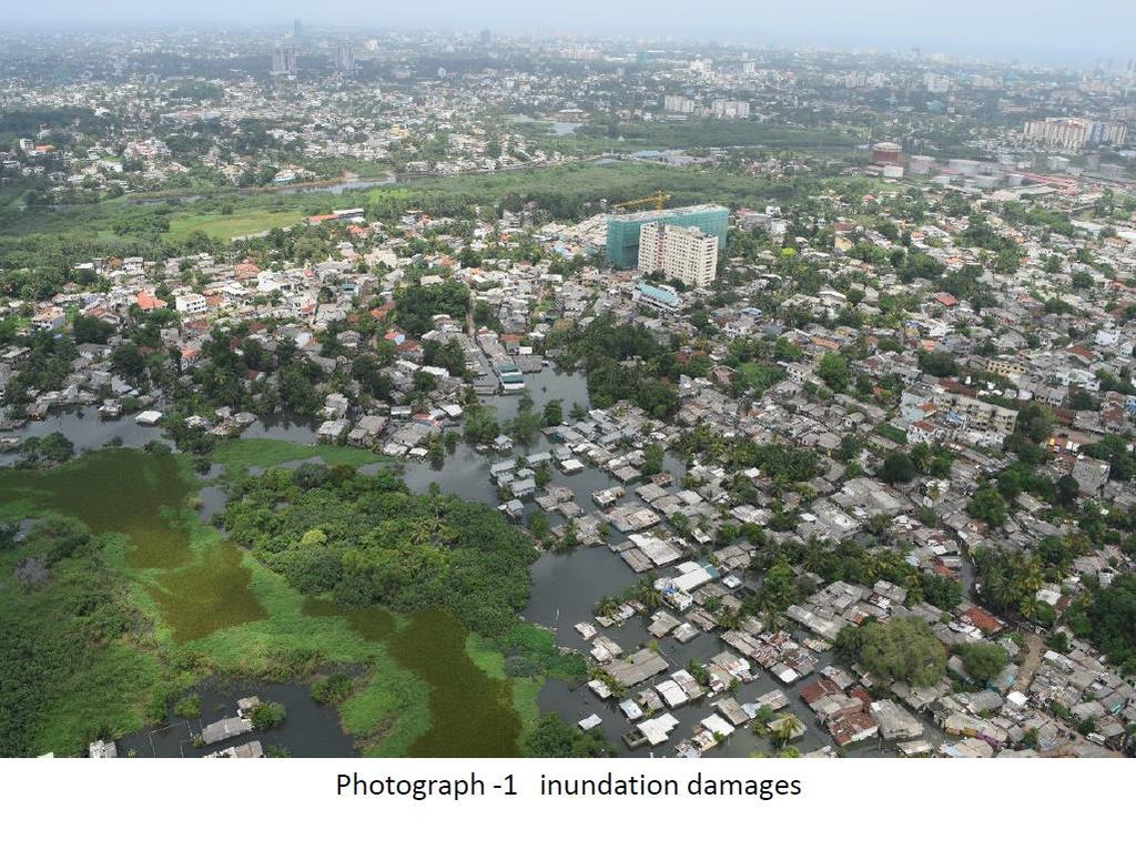
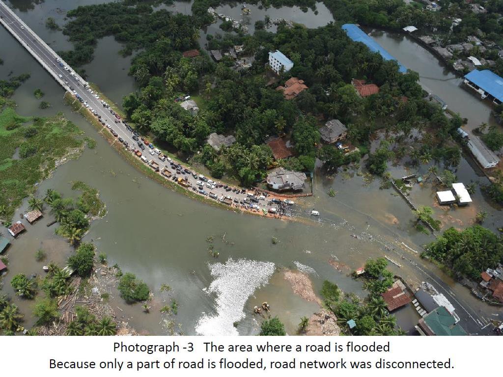
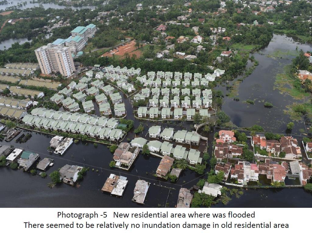
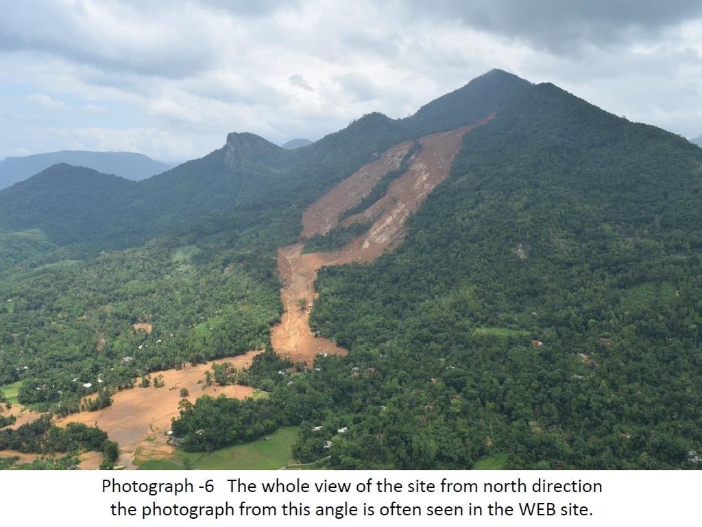
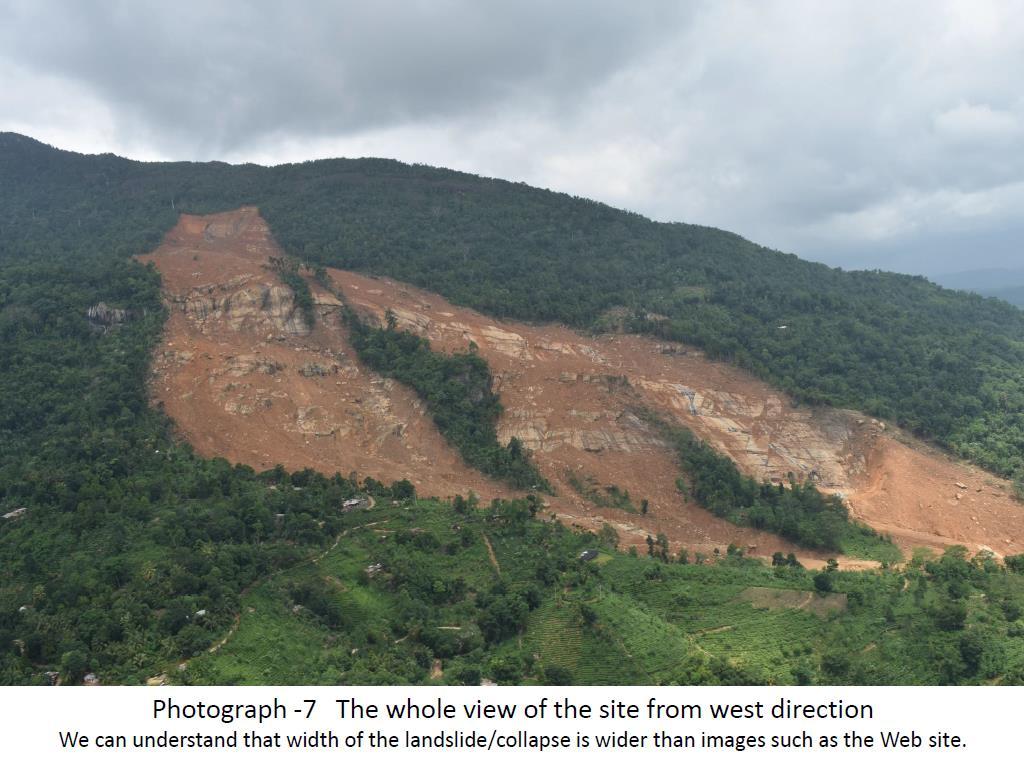
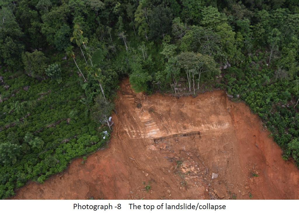
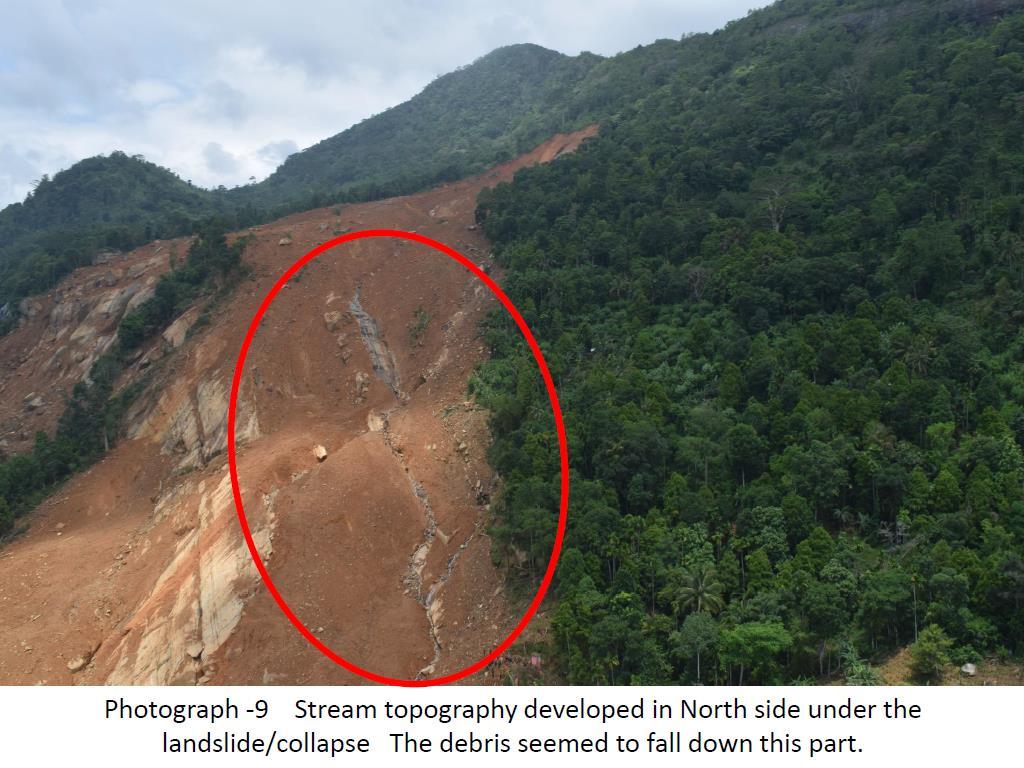
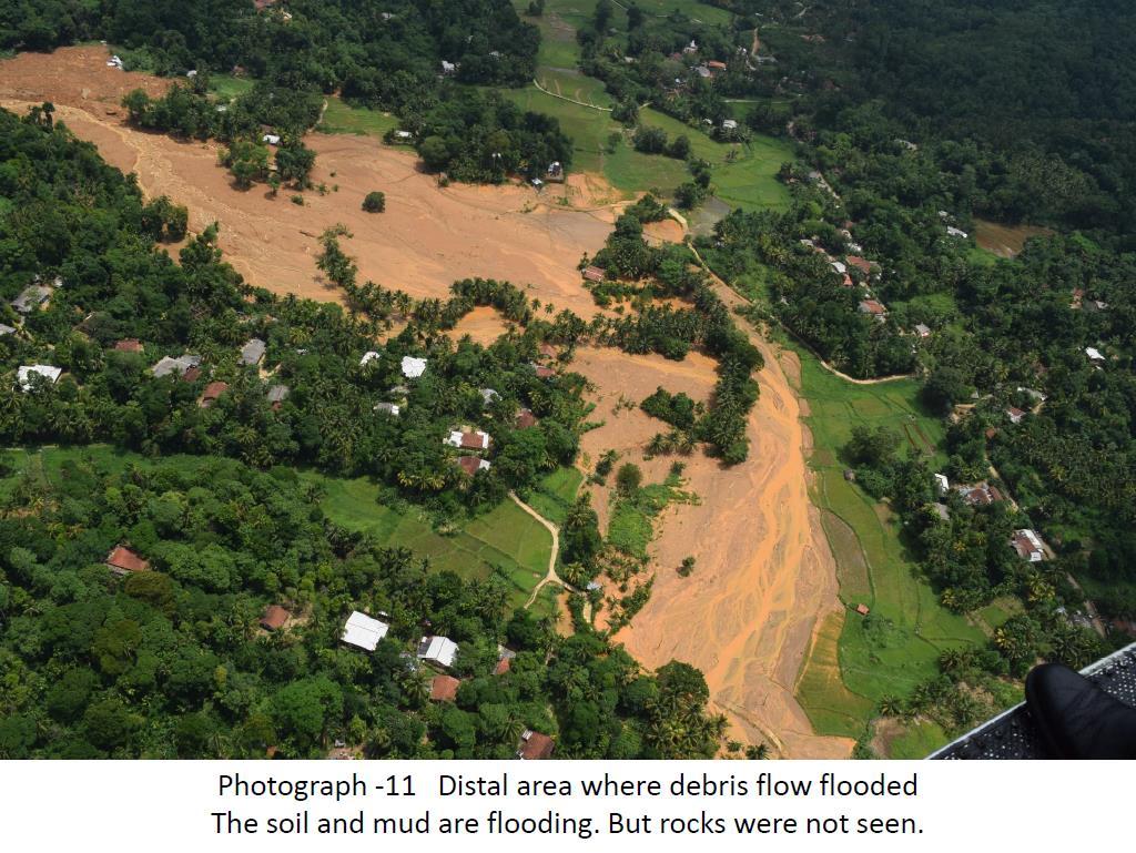
5 The details are as follows; basically, the low ground and marshy land had been flooded [cf. photograph -1]. Much damage could not been seen in a place where a dike like thing (bund) was seemed. [cf. photograph -2]. Basically, it is thought that there was much inundation in the areas out of dike. According to the information from the Ministry of Disaster Management (MoDM), more inundation damages have occurred in places where there are illegal settlements. Many places where the ground elevation is low were flooded and road network was disturbed. [, cf. photograph -3]. Some sections were flooded as the water came out from some sections where the height of the dike was not appropriate. [cf. photograph -4]. Impressively, similar to Japan, there seemed to be relatively little inundation damages in the settlement area which from the olden times. On the other hand, some points of new residential areas were flooded [cf. photograph -5] Aranayake disaster Many photographs in the WEB sites and news carried pictures of the north direction of the landslide, and it seemed that the crosswise direction of the landslide was not very large [cf. photograph -6]. However, we were able to confirm that it is an unexpectedly wide disaster by the aerial survey [cf. photograph -7]. Even though the detailed depth of the landslide/collapse could not be identified after confirming the most upper part of the landslide,the depth of the landslide/collapse seem to be not deeper than imagination [cf. photograph -8]. According to the photographs published in the websites, it seemed that the debris flowed down at least from two directions. But it was thought that the mass of collapse fell down to the stream topography which was developed in the right side of landslide/collapse[cf. photograph -9] The mass of collapse flew down from 2 directions, and it is assumed that it joined into one stream topography, and ran down as a debris flow. The joint debris ran down straightly, and most of it seemed to be deposited near the end point of valley [near red circles of the photograph -10]. After the debris flow deposited, it flooded along the Northwest side of cultivated land. It looked like soil and mud, and rocks were not seen [cf. photograph -11]. But there was a news video, which shows the remaining mass of collapse flowing down from landslide/collapse area. It was expected that if the rain continued after the disaster, there is a risk of flowing down mass of collapse in the future. Photograph -11, it seems that relatively large stones deposited in the area where the water came down. Further it was thought that the mass of collapse might have run down to the neighborhood by the heavy rain after the disaster. 7. Measures that to be taken in future The detailed inundation points cannot be verified through an aerial survey, therefore it is necessary to conduct a field survey immediately after a disaster while the flood traces are left. Currently LiDAR survey project is being implemented in the Survey Department with the cooperation of JICA. The project will produce LiDAR survey results around Colombo area. In 5
6 future the Ministry of Disaster Management (including DoM and NBRO) and the Survey Department is expected to collaborate closely to effectively utilize the results of the LiDAR data. We are analyzing the topography of the Aranayake Landslide using approximately 80 photographs taken during the aerial survey and satellite data, such as the ALOS date [cf. attached document]. However, it is really necessary to conduct a field survey in future, to understand the angle of slope and sediments of the mass of collapse and so on. Currently water continues to flow in the collapsed area, where debris flow ran down, and also the mass of collapse mud still remain. In addition, it is assumed that long-term rain may cause destabilization of the land in the surrounding area. Therefore, the inhabitants around this area need to pay more attention for the consecutive rain. 8. Proposal based on survey results The experts in the fields of flooding and sediment disaster management must conduct an aerial survey soon after a disaster to understand any secondary disasters as emergency disaster correspondence of the government. Even though the JICA office checked the possibility to charter a helicopter for the aerial survey it was found out that the helicopters are not available due to the high demand. Therefore we had to use a helicopter owned by Air Force of Sri Lanka. Sometimes media teams charter the helicopters during the early stages after a disaster and produce movies about disasters. In our opinion, it is necessary to conduct such aerial surveys as disaster correspondence during or after a disaster by DMC, NBRO and so on. We think that it is necessary to establish a proper coordination mechanism to get a helicopter to carry out such aerial surveys as and when necessary. As mentioned in above "6 - Measures to be taken in future", it is necessary to conduct a detailed damage assessment survey. Although it is unknown whether Sri Lanka has past experience in conducting flood damage assessment surveys in Sri Lanka, it is important to use the results of the LiDAR project of JICA, to grasp whole view of the damage. It was found out that the inundation damages in the new residential areas are similar to the situation in Japan. With urban developments around the Colombo area, it is assumed that the areas with the risk of the flood spreads. Therefore, the Master Plan (M/P) for flood and drainage control is necessary. Flood and drainage control M/P will include river improvement measures in view of water balance of the basin and land use regulations. Drainage of inland flood water, locations of retarding basins and land use regulations to keep enough space for retarding as well as flood control counter measures should be included in M/P study. After confirming this sediment disaster outbreak point in the Landslide Hazard Zonation Map of NBRO, collapse/landslide outbreak point is set as "Landslides are most likely to occur 6 " from 6 In "Landslide Hazard Zonation Map", the risk of the landslide was divided into four phases. The most dangerous area is classified as "Landslides are most likely to occur", the second is "Landslides are to be expected ", the third is "Modest level of landslide hazard exists". The safest area is classified as "Landslides not likely to occur". 6
7 the projection only from aerial survey. Therefore, it may be said that NBRO has recognized the risk of the disaster outbreak spot that became the trigger of this disaster. But, about the affected area as the phenomenon of sediment movement, we cannot say that the map could forecast/predict the affected area from present "Landslide Hazard Zonation Map". This disaster seems landslide/ becomes a debris flow only from aerial survey. Currently in Sri Lanka, it does not seem to be classified the debris flow or to identify the flooding area of the debris flow. Therefore, it is thought that the change of the viewpoint is necessary/important to grasp the "affected areas" (disaster area) from landslide/collapse in future. 9. Acknowledgment JICA survey team would like to acknowledge the support given by the following members in compiling this report. ESS (Earth System Science) consultant team members of TCLMP for carrying out data analysis mainly, JAXA (Japan Aerospace Exploration Agency) for supplying A-LOS data and JICA LiDAR survey project team for supplying aerial photo and data. 7

8 8

9 9

10 10
11 11
12 12

13 13

14 Annex Comparison of Before/After Landslide Before (26th Dec 2015) After (22nd May 2016) Ortho Image by LiDAR Survey 0.5 m Resolution LiDAR : Light Detection and Ranging Provided from the Survey Department of Sri Lanka, which is prepared by JICA s Development Study Capacity Development Project for Creating Digital Elevation Model Enabling Disaster Resilience Aerial Photo by Chopper 0.5m Resolution 1


 by aerial photo only.")

15 Comparison of Before/After Landslide Affected Settlement JICA will not bear full responsibility for this result. It is difficult to accurately determine whether the settlement or working hut (no resident) by aerial photo only. And this result is expected to include error of the quantity of settlement by the vegetation cover. 2

16 Topographic Map SRTM Ver. 3.0 Aerial Photo Analysis SRTM : Shuttle Radar Topography Mission 30m Resolution Free and Open Source 0.5m Resolution 3

17 Topographic Map ALOS World 3D Aerial Photo Analysis C JAXA included NTT DATA and RESTEC ALOS : Advanced Land Observing Satellite 5.0m Resolution 0.5m Resolution 4
18 Topographic Map LiDAR Survey Aerial Photo Analysis LiDAR : Light Detection and Ranging 2.0m Resolution Provided from the Survey Department of Sri Lanka, which is prepared by JICA s Development Study Capacity Development Project for Creating Digital Elevation Model Enabling Disaster Resilience 0.5m Resolution 5


19 Topographic Map and Slope LiDAR Survey Slope Classification by LiDAR Survey 6

20 Estimation of Amount of Soil Movement LiDAR Survey + Aerial Photo Analysis Amount of Soil Movement 7
21 Cross Section A A 800 B A LiDAR Cross Section Aerial Photo Cross Section 1000 A B 700 B A B LiDAR Cross Section Aerial Photo Cross Section Amount of Soil Movement 8
Progress Report. Flood Hazard Mapping in Thailand
 Progress Report Flood Hazard Mapping in Thailand Prepared By: Mr. PAITOON NAKTAE Chief of Safety Standard sub-beuro Disaster Prevention beuro Department of Disaster Prevention and Mitigation THAILAND E-mail:
photo courtesy of
 BRITISH VIRGIN ISLANDS REPORT TROPICAL STORM JEANNE photo courtesy of www.bviplatinum.com PREPARED BY THE DEPARTMENT OF DISASTER MANAGEMENT 1 EVENT 13 th -16 th September, 2004 TROPICAL STORM JEANNE Sequence
FLOODS IN SOUTHWESTERN SRI LANKA IN MAY 2017
 FLOODS IN SOUTHWESTERN SRI LANKA IN MAY 2017 Foundation for Environment, Climate and Technology C/o Mahaweli Authority of Sri Lanka, Digana Village, Rajawella, Kandy, KY 20180, Sri Lanka Citation Lokuhetti,
COUNTRY PRESENTATION ON MR JAYNAL ABEDIN JOINT SECRETARY ( WORKS & DEVELOPMENT ) MINISTRY OF DEFENCE
 MINISTRY OF DEFENCE") COUNTRY PRESENTATION ON By MR JAYNAL ABEDIN JOINT SECRETARY ( WORKS & DEVELOPMENT ) MINISTRY OF DEFENCE Bangladesh Geographical Location of Bangladesh Bangladesh Country at a Glance Physical Features 1,230
COUNTRY PRESENTATION ON By MR JAYNAL ABEDIN JOINT SECRETARY ( WORKS & DEVELOPMENT ) MINISTRY OF DEFENCE Bangladesh Geographical Location of Bangladesh Bangladesh Country at a Glance Physical Features 1,230
Georeferencing and Satellite Image Support: Lessons learned, Challenges and Opportunities
 Georeferencing and Satellite Image Support: Lessons learned, Challenges and Opportunities Shirish Ravan shirish.ravan@unoosa.org UN-SPIDER United Nations Office for Outer Space Affairs (UNOOSA) UN-SPIDER
Spatial Planning Platform Meeting
 Spatial Planning Platform Meeting August 1 st 2018 Part II Session 1 Design and Implementation of National and Regional Planning for Inclusive Growth Spatial info from space based technologies RESTEC (Remote
Sentinel Asia System Operation for Disaster Management in Sri Lanka Major General L.B.R. Mark (Retd) Director General Disaster Management Centre
 Director General Disaster Management Centre") Sentinel Asia System Operation for Disaster Management in Sri Lanka Major General L.B.R. Mark (Retd) Director General Disaster Management Centre Government of Sri Lanka OUTLINE Background Disasters in
Sentinel Asia System Operation for Disaster Management in Sri Lanka Major General L.B.R. Mark (Retd) Director General Disaster Management Centre Government of Sri Lanka OUTLINE Background Disasters in
4 th Joint Project Team Meeting for Sentinel Asia 2011
 A Revisit on the Structural Flood Mitigation Measure with the Application of Remote Sensing and GIS in Gin River Basin, Sri Lanka 4 th Joint Project Team Meeting for Sentinel Asia 2011 Geoinformatics Center
What Are Disasters? The Rescue Kids Trio!
 The Rescue Kids Trio! What Are Disasters? This manual was made possible through funding by the Council of Local Authorities for International Relations. Disasters and emergency preparedness Emergency preparedness
March 2007 The Survey Department of Sri Lanka
 Contribution of Survey Department of Sri Lanka for Mitigation of Disasters in Sri Lanka K.A.U.N.Kasthuri Deputy Surveyor General (Information Technology) March 2007 The Survey Department of Sri Lanka 1
Mainstream Space Technology in Implementing SFDRR - GPSTAR. Srimal Samansiri Disaster Management Centre Government of Sri Lanka
 Mainstream Space Technology in Implementing SFDRR - GPSTAR Srimal Samansiri Disaster Management Centre Government of Sri Lanka SFDRR Priority Actions Effective use of Space technology in SFDRR Priority
Development of Tropical Storm Falcon (Meari) over the Philippines
 over the Philippines") Development of Tropical Storm Falcon (Meari) over the Philippines June 20-27, 2011 At the end of June, 2011, the Philippines were struck again by Tropical storm Falcon (Meari). After gaining strength over
Development of Tropical Storm Falcon (Meari) over the Philippines June 20-27, 2011 At the end of June, 2011, the Philippines were struck again by Tropical storm Falcon (Meari). After gaining strength over
Landslide Disaster Management in Sri Lanka and Nichola Oya as a Case study. Group 16 Gamini Jayathissa Udeni Nawagamuwa
 Landslide Disaster Management in Sri Lanka and Nichola Oya as a Case study Group 16 Gamini Jayathissa Udeni Nawagamuwa Taiwan Sri lanka >2582 mm, max >5000mm NE= Nov. to Feb 1750 2500 mm >2500 mm Central
NGIAs' roles in successful disaster response
 The Second UN-GGIM-AP Plenary Meeting NGIAs' roles in successful disaster response Japan Teheran Iran 28 October 2013 Shin-ichi SAKABE, Director of International Affairs Division Geospatial Information
National Platform for Disaster Risk Reduction in Sri Lanka
 National Platform for Disaster Risk Reduction in Sri Lanka Eng.(Dr) Asiri Karaunwardena Director General / National Building Research Organization Ministry of Disaster Management Sri Lanka National Platform
Flash flood disaster in Bayangol district, Ulaanbaatar
 Flash flood disaster in Bayangol district, Ulaanbaatar Advanced Training Workshop on Reservoir Sedimentation Management 10-16 October 2007. IRTCES, Beijing China Janchivdorj.L, Institute of Geoecology,MAS
9. Case study on disaster events using radar data
 9. Case study on disaster events using radar data 9 February 2018 Masahito ISHIHARA Former Meteorologist/Researcher of Japan Meteorological Agency Former Professor of Kyoto University 9. Case study on
Sri Lanka Enhancing the Role of ICTs for Disaster Risk Management
 Workshop on ICT for Promoting Inclusive and Disaster Resilient Development Ulaanbaatar, Mongolia Sri Lanka Enhancing the Role of ICTs for Disaster Risk Management Kanchana Thudugala Programme Head, eservices
DISASTER INFORMATION MANAGEMENT SYSTEM Sri Lanka
 DISASTER INFORMATION MANAGEMENT SYSTEM Sri Lanka 15 March 2016 - Partnership Meeting Global Centre for Disaster Statistics SRIMAL SAMANSIRI ASSISTANT DIRECTOR R&D DISASTER MANAGEMENT CENTRE Overview Country
Use of Geospatial data for disaster managements
 Use of Geospatial data for disaster managements Source: http://alertsystemsgroup.com Instructor : Professor Dr. Yuji Murayama Teaching Assistant : Manjula Ranagalage What is GIS? A powerful set of tools
Team 09 Nguyen chau lan (Vietnam) Dilum Wannigasekara (Sri lanka)
 Dilum Wannigasekara (Sri lanka)") Team 09 Nguyen chau lan (Vietnam) Dilum Wannigasekara (Sri lanka) contents Part I: Landslide in Vietnam Part II: Case study of Landslide in sri lanka Part I: Introduction of Landslide in hoa binh province
Team 09 Nguyen chau lan (Vietnam) Dilum Wannigasekara (Sri lanka) contents Part I: Landslide in Vietnam Part II: Case study of Landslide in sri lanka Part I: Introduction of Landslide in hoa binh province
GENERAL. CHAPTER 1 BACKGROUND AND PURPOSE OF THE GUIDELINES Background of the Guidelines Purpose of the Guidelines...
 GENERAL CHAPTER 1 BACKGROUND AND PURPOSE OF THE GUIDELINES... 1 1.1 Background of the Guidelines... 1 1.2 Purpose of the Guidelines... 3 CHAPTER 2 APPLICATION OF THE GUIDELINES... 3 2.1 Potential Users
Innovative Ways to Monitor Land Displacement
 ARTICLE Innovative Ways to Monitor Land Displacement When people think about landslides, they usually imagine large mud streams which cause considerable loss of life. Whereas such large-scale disasters
CYCLONE LAILA RED WARNING. May 19, 2010 (23.45 hrs)
") CYCLONE LAILA RED WARNING May 19, 2010 (23.45 hrs) The severe cyclonic storm LAILA over westcentral and adjoining southwest Bay of Bengal remained practically stationary and lay centred at 2030 hrs IST
CYCLONE LAILA RED WARNING May 19, 2010 (23.45 hrs) The severe cyclonic storm LAILA over westcentral and adjoining southwest Bay of Bengal remained practically stationary and lay centred at 2030 hrs IST
Establishment of WINDS Ground Station in Sri Lanka. By G.K.D. Amarawardena Additional Secretary Ministry of Disaster Management Sri Lanka
 Establishment of WINDS Ground Station in Sri Lanka By G.K.D. Amarawardena Additional Secretary Ministry of Disaster Management Sri Lanka Contents Background SAS Implementation Progress of WINDS establishment
Early Warning System and Role of IMD. Manmohan Singh Meteorological Centre Shimla
 Early Warning System and Role of IMD Manmohan Singh Meteorological Centre Shimla India a land with a unique climatic regime Two monsoon seasons (southwest & northeast monsoons) Two cyclone seasons (pre
Roles of NGII in successful disaster management
 The Second UN-GGIM-AP Plenary Meeting Roles of NGII in successful disaster management Republic of Korea Teheran Iran 28 October 2013 Sanghoon Lee, Ph.D. NGII Outline Type of Disasters Occur in Korea Practical
Thai Meteorological Department, Ministry of Digital Economy and Society
 Thai Meteorological Department, Ministry of Digital Economy and Society Three-month Climate Outlook For November 2017 January 2018 Issued on 31 October 2017 -----------------------------------------------------------------------------------------------------------------------------
Tropical Update. 11 AM EDT Wednesday, October 10, 2018 Hurricane Michael, Hurricane Leslie & Tropical Storm Nadine, Caribbean Low (40%)
") Tropical Update 11 AM EDT Wednesday, October 10, 2018 Hurricane Michael, Hurricane Leslie & Tropical Storm Nadine, Caribbean Low (40%) This update is intended for government and emergency response officials,
Tropical Update 11 AM EDT Wednesday, October 10, 2018 Hurricane Michael, Hurricane Leslie & Tropical Storm Nadine, Caribbean Low (40%) This update is intended for government and emergency response officials,
Regional Flash Flood Guidance and Early Warning System
 WMO Training for Trainers Workshop on Integrated approach to flash flood and flood risk management 24-28 October 2010 Kathmandu, Nepal Regional Flash Flood Guidance and Early Warning System Dr. W. E. Grabs
JMA/WMO WORKSHOP ON EFFECTIVE TROPICAL CYCLONE WARNING IN SOUTHEAST ASIA
 JMA/WMO WORKSHOP ON EFFECTIVE TROPICAL CYCLONE WARNING IN SOUTHEAST ASIA TROPICAL CYCLONE MONITORING IN LAO PDR TOKYO, JAPAN 11 14 March 2014 Ministry of Natural Resource and Environment (MONRE) Department
JCOMM-CHy Coastal Inundation Forecasting Demonstration Project (CIFDP)
") WMO World Meteorological Organization Working together in weather, climate and water JCOMM-CHy Coastal Inundation Forecasting Demonstration Project (CIFDP) Coastal Flooding & Vulnerable Populations Coastal
WMO World Meteorological Organization Working together in weather, climate and water JCOMM-CHy Coastal Inundation Forecasting Demonstration Project (CIFDP) Coastal Flooding & Vulnerable Populations Coastal
Satellite-based applications for water resources management in Asia and Pacific region
 Satellite-based applications for water resources management in Asia and Pacific region Ko Hamamoto Japan Aerospace Exploration Agency The views expressed in this paper/presentation are the views of the
Haiti and Dominican Republic Flash Flood Initial Planning Meeting
 Dr Rochelle Graham Climate Scientist Haiti and Dominican Republic Flash Flood Initial Planning Meeting September 7 th to 9 th, 2016 Hydrologic Research Center http://www.hrcwater.org Haiti and Dominican
National Report on Weather Forecasting Service
 MINISTRY OF WATER RESOURCES AND METEOROLOGY DEPARTMENT OF METEOROLOGY, CAMBODIA National Report on Weather Forecasting Service Tokyo, 11-15 March 2014 Department of Meteorology, Cambodia Presentation Outline
Republic of Mozambique
 Republic of Mozambique Second Expert's Symposium on Multi-Hazard Early Warning Systems with focus on the Role of National Meteorological and Hydrological Services 5-7 May 2009, Toulouse France 1. Background
GC Briefing. Weather Sentinel Tropical Storm Michael. Status at 8 AM EDT (12 UTC) Today (NHC) Discussion. October 11, 2018
 Today (NHC) Discussion. October 11, 2018") GC Briefing Weather Sentinel Tropical Storm Michael October 11, 2018 After making landfall as a high-end category-4 hurricane on the Florida Panhandle, Michael weakened to tropical storm status early this
GC Briefing Weather Sentinel Tropical Storm Michael October 11, 2018 After making landfall as a high-end category-4 hurricane on the Florida Panhandle, Michael weakened to tropical storm status early this
Need of Proper Development in Hilly Urban Areas to Avoid
 Need of Proper Development in Hilly Urban Areas to Avoid Landslide Hazard Dr. Arvind Phukan, P.E. Cosultant/Former Professor of Civil Engineering University of Alaska, Anchorage, USA RI District Governor
Landslide monitoring system in Iceland. Harpa Grímsdóttir Jón Kristinn Helgason NVE, Oslo, October
 Landslide monitoring system in Iceland Harpa Grímsdóttir Jón Kristinn Helgason NVE, Oslo, October 26 2016 History Avalanches and landslides have caused extensive damages and loss of human lives in Iceland
South Asian Climate Outlook Forum (SASCOF-6)
") Sixth Session of South Asian Climate Outlook Forum (SASCOF-6) Dhaka, Bangladesh, 19-22 April 2015 Consensus Statement Summary Below normal rainfall is most likely during the 2015 southwest monsoon season
Sixth Session of South Asian Climate Outlook Forum (SASCOF-6) Dhaka, Bangladesh, 19-22 April 2015 Consensus Statement Summary Below normal rainfall is most likely during the 2015 southwest monsoon season
THE UNITED REPUBLIC OF TANZANIA MINISTRY OF WORKS, TRANSPORT AND COMMUNICATION TANZANIA METEOROLOGICAL AGENCY
 THE UNITED REPUBLIC OF TANZANIA MINISTRY OF WORKS, TRANSPORT AND COMMUNICATION TANZANIA METEOROLOGICAL AGENCY CLIMATE OUTLOOK FOR TANZANIA MARCH MAY, 2018 MASIKA RAINFALL SEASON Highlights for March May,
2014 Summer training course for slope land disaster reduction Taipei, Taiwan, Aug
 MINISTRY OF SCIENCE AND TECHNOLOGY HYDROTECH RESEARCH INSTITUTE MINISTRY OF NATURAL RESOURCES AND ENVIRONMENT VIETNAM INSTITUTE OF GEOSCIENCES AND MINERAL RESOURCES (VIGMR) 2014 Summer training course
ColomboArts. Volume II Issue I Dynamic Trends of Intensity of Rainfall Extremes in Sri Lanka
 ColomboArts Volume II Issue I 2017 Dynamic Trends of Intensity of Rainfall Extremes in Sri Lanka R.M.S.S.Sanjeewani, 1 Lasantha Manawadu 2 1 Department of Transport and Logistics Management, University
Hurricane Preparation and Recovery. October 11, 2011 Jon Nance, Chief Engineer, NCDOT
 Hurricane Preparation and Recovery October 11, 2011 Jon Nance, Chief Engineer, NCDOT North Carolina & Severe Weather Our state often bears the brunt of storms, which include: Ice storms Snow storms Heavy
- facilitate the preparation of landslide inventory and landslide hazard zonation maps for the city, - development of precipitation thresholds,
 Date of Submission 29.03.2012 IPL Project Proposal Form 2012 (MAXIMUM: 3 PAGES IN LENGTH) 1. Project Title: (2 lines maximum)-introducing Community-based Early Warning System for Landslide Hazard Management
Meteorological Hazards and Current Approach to Observing, Modelling and Predicting Severe Events in Sri Lanka
 Regional Workshop on Impact-based Forecasts in RA II (Asia) 7-9, November, 2017, Seoul, Republic of Korea Meteorological Hazards and Current Approach to Observing, Modelling and Predicting Severe Events
Disaster Management and Spatial Data An Experience of Sri Lanka for Joint project team meeting 2012
 Disaster Management and Spatial Data An Experience of Sri Lanka for Joint project team meeting 2012 1 by Padma Kumara Withana Provincial Surveyor General Uva Province 2 Out line ü Introduction ü Natural
JICA s Cooperation for NMHSs. Taisuke Watanabe Japan International Cooperation Agency
 JICA s Cooperation for NMHSs Taisuke Watanabe 28 Oct, 2014 JICA s Assistant Approach for Hydrological and Meteorological Services Assistance for improvement of Hydrological and Meteorological Services
ANNOUNCEMENT WMO/ESCAP PANEL ON TROPICAL CYCLONES THIRTY-EIGHTH SESSION NEW DELHI, INDIA
 WMO IMD ESCAP ANNOUNCEMENT THIRTY-EIGHTH SESSION NEW DELHI, INDIA (21-25 February 2011) HISTORICAL BACKGROUND The tropical cyclones are particularly severe in the north Indian Ocean region. The northern
International Journal of Integrated Sciences & Technology 2 (2016) 55-61
 55-61") International Journal of Integrated Sciences & Technology 2 (2016) 55-61 Changes in Latent Heat Energy and Moist Static Energy Contents of the Atmosphere over Bangladesh and Neighbourhood during the Formation
International Journal of Integrated Sciences & Technology 2 (2016) 55-61 Changes in Latent Heat Energy and Moist Static Energy Contents of the Atmosphere over Bangladesh and Neighbourhood during the Formation
Introduction to Environmental Geology, 5e Case History: Indonesian Tsunami Indonesian Tsunami (2) Introduction Historic Tsunamis
 Introduction Historic Tsunamis") 1 2 3 4 5 6 7 8 9 Introduction to Environmental Geology, 5e Chapter 7 Tsunami Case History: Indonesian Tsunami December 26, 2004, within a few hours, close to 250,000 people were killed With no warning
1 2 3 4 5 6 7 8 9 Introduction to Environmental Geology, 5e Chapter 7 Tsunami Case History: Indonesian Tsunami December 26, 2004, within a few hours, close to 250,000 people were killed With no warning
The AIR Tropical Cyclone Model for India
 The AIR Tropical Cyclone Model for India Tropical cyclones have caused millions, and even billions, of dollars in damage in India. The growing number of properties on the coast, together with growing insurance
Joint Meeting of RA II WIGOS Project and RA V TT-SU on 11 October 2018 BMKG Headquarter Jakarta, Indonesia. Mrs. Sinthaly CHANTHANA
 Joint Meeting of RA II WIGOS Project and RA V TT-SU on 11 October 2018 BMKG Headquarter Jakarta, Indonesia Mrs. Sinthaly CHANTHANA Lao PDR Background Department of Meteorology and Hydrology ( DMH ) in
Sentinel Asia Tsunami Working Group
 Sentinel Asia Tsunami Working Group Co-Chairman: Prof. Shunichi Koshimura Abdul Muhari, PhD 4 th Joint Project Team Meeting (JPTM 2017): Sentinel Asia STEP 3 Abdul MUHARI, PhD Ministry of Marine Affairs
FLOOD HAZARD AND RISK ASSESSMENT IN MID- EASTERN PART OF DHAKA, BANGLADESH
 FLOOD HAZARD AND RISK ASSESSMENT IN MID- EASTERN PART OF DHAKA, BANGLADESH Muhammad MASOOD MEE07180 Supervisor: Prof. Kuniyoshi TAKEUCHI ABSTRACT An inundation simulation has been done for the mid-eastern
Ms. Latoya Regis. Meteorologist Hydrometeorological Service, Guyana
 Ms. Latoya Regis Meteorologist Hydrometeorological Service, Guyana Background Ninety percent (90%) of Guyana s population resides along the (Atlantic) Coast, which is below mean sea level and accounts
Disaster Management in Republic of Korea
 The Third UN-GGIM-AP Plenary Meeting Disaster Management in Republic of Korea ~Coordination among NGIA & Other Related Organizations and Recommendations~ Bali Indonesia 10 November 2014 Sanghoon Lee, Ph.D.
National Public Weather and Warning Services in the Swaziland Meteorological Service Dennis S.Mkhonta /
 National Public Weather and Warning Services in the Swaziland Meteorological Service Dennis S.Mkhonta dennis.mkhonta@gmail.com / dennis@swazimet.gov.sz Introduction Swaziland s geographical position exposes
Sediment Disasters and Mass Movement (SD&M 2 ) NATIONAL DISASTER MANAGEMENT RESEARCH INSTITUTE
 NATIONAL DISASTER MANAGEMENT RESEARCH INSTITUTE") Sediment Disasters and Mass Movement (SD&M 2 ) Contents Outline of SD&M 2 Major outcomes Issues and conclusions Prologue Mass movement in Ulsan, Korea by Typhoon CHABA on Oct. 5. Outline of SD&M 2 Activities
Sediment Disasters and Mass Movement (SD&M 2 ) Contents Outline of SD&M 2 Major outcomes Issues and conclusions Prologue Mass movement in Ulsan, Korea by Typhoon CHABA on Oct. 5. Outline of SD&M 2 Activities
Disaster Risk Management in India. Kamal Kishore New Delhi, 27 October 2016
 Disaster Risk Management in India Kamal Kishore New Delhi, 27 October 2016 Hazard, Exposure and Vulnerability Disaster Prevention Mitigation Hurricane Matthew: Cuba & Haiti Emergency Response Coordination
Flood Forecasting in Bangladesh
 Flood Forecasting in Bangladesh Types of Flood ing Flood ing can be divided into two categories: Flood ing in the rivers caused by upstream rise of river stage as well as rainfall in the basin. Overland
Flash flood forecasting and warning infrastructures of National Meteorology and Hydrological Services of Cambodia
 Development and Implementation of the South East Asia Flash Flood Guidance System (SEAFFGS) Ha Noi, Viet Nam, 20-23 November 2017 Flash flood forecasting and warning infrastructures of National Meteorology
EFFECTIVE TROPICAL CYCLONE WARNING IN BANGLADESH
 Country Report of Bangladesh On EFFECTIVE TROPICAL CYCLONE WARNING IN BANGLADESH Presented At JMA/WMO WORKSHOP ON EFFECTIVE TROPICAL CYCLONE WARNING IN SOUTHEAST ASIA Tokyo, Japan,11-14 March 2014 By Sayeed
Copernicus Overview. Major Emergency Management Conference Athlone 2017
 Copernicus Overview Major Emergency Management Conference Athlone 2017 Copernicus is a European programme implemented by the European Commission. The services address six thematic areas: land, marine,
Rebuilding Flood-Conscious Society
 A zone where strong flood flow or river bank erosion by levee breach are anticipated, which likely to occur collapsing/washing away of house. Set up the joint councils by relative stakeholders(river managers,
Capacity Building Programme
 Capacity Building Programme 14-17 August 2012 Space Technology for improving Hazard Mapping in Sri Lanka An event organised as a follow up of the UN-SPIDER Technical Advisory Mission to Sri Lanka - 17-21
Improvement of Hazard Assessment and Management in the Philippines
 Improvement of Hazard Assessment and Management in the Philippines (2014 Summer Training Course for Slope Land Disaster Reduction) Ian Alejandrino (Philippines) Nguyen Manh Hieu (Vietnam) Presentation
ROLE OF INDIA METEOROLOGICAL DEPARTMENT IN MANAGEMENT OF METEOROLOGICAL HAZARDS IN INDIA M MOHAPATRA
 ROLE OF INDIA METEOROLOGICAL DEPARTMENT IN MANAGEMENT OF METEOROLOGICAL HAZARDS IN INDIA M MOHAPATRA INDIA METEOROLOGICAL DEPARTMENT NEW DELHI-110003 mohapatraimd@gmail.com Introduction Presentation layout
Tropical Update. 5 PM EDT Sunday, September 10, 2017 Hurricane Irma, Hurricane Jose, Tropical Wave (60%)
") Tropical Update 5 PM EDT Sunday, September 10, 2017 Hurricane Irma, Hurricane Jose, Tropical Wave (60%) This update is intended for government and emergency response officials, and is provided for informational
Tropical Update 5 PM EDT Sunday, September 10, 2017 Hurricane Irma, Hurricane Jose, Tropical Wave (60%) This update is intended for government and emergency response officials, and is provided for informational
DRR-related mandates and relevant activities and projects of RA III
 DRR-related mandates and relevant activities and projects of RA III 2015 Meeting of the Disaster Risk Reduction Focal Points of WMO Regional Associations, Technical Commissions and Programmes (DRR FP RA-TC-TP)
Natural hazards in Glenorchy Summary Report May 2010
 Natural hazards in Glenorchy Summary Report May 2010 Contents Glenorchy s hazardscape Environment setting Flood hazard Earthquakes and seismic hazards Hazards Mass movement Summary Glossary Introduction
Coastal Inundation Forecasting Demonstration Project CIFDP. Flood Forecasting Initiative-Advisory Group (FFI-AG 3), Geneva, 5-7 Dec, 2017
, Geneva, 5-7 Dec, 2017") Coastal Inundation Forecasting Demonstration Project CIFDP Flood Forecasting Initiative-Advisory Group (FFI-AG 3), Geneva, 5-7 Dec, 2017 Coastal Flooding & Vulnerable Populations Coastal populations are
Coastal Inundation Forecasting Demonstration Project CIFDP Flood Forecasting Initiative-Advisory Group (FFI-AG 3), Geneva, 5-7 Dec, 2017 Coastal Flooding & Vulnerable Populations Coastal populations are
Flood Hazard Inundation Mapping. Presentation. Flood Hazard Mapping
 Flood Hazard Inundation Mapping Verne Schneider, James Verdin, and JeradBales U.S. Geological Survey Reston, VA Presentation Flood Hazard Mapping Requirements Practice in the United States Real Time Inundation
Tropical Update. 5 AM EDT Tuesday, September 12, 2017 Post-Tropical Cyclone Irma, Hurricane Jose, & Tropical Wave (10%)
") Tropical Update 5 AM EDT Tuesday, September 12, 2017 Post-Tropical Cyclone Irma, Hurricane Jose, & Tropical Wave (10%) This update is intended for government and emergency response officials, and is provided
Tropical Update 5 AM EDT Tuesday, September 12, 2017 Post-Tropical Cyclone Irma, Hurricane Jose, & Tropical Wave (10%) This update is intended for government and emergency response officials, and is provided
Chantale Bijoux Meteorological Officer
 Chantale Bijoux Meteorological Officer Introduction The Seychelles s National Meteorological Services plays a vital role in providing weather and climate information including severe weather changes, therefore
National Situation Report As of 3:00 a.m. EDT, Thursday, September 21, 2017 Table of Contents Current Operations Monitoring Recovery
 25k Overview National Situation Report As of 3:00 a.m. EDT, Thursday, September 21, 2017 Table of Contents Current Operations Monitoring Recovery FEMA Headquarters Status FEMA Region Status NRCC Level
The Development of the Slope Failure Management System
 FANG Ji, Akiyuki KAWASAKI, Satoru SADOHARA The Development of the Slope Failure Management System There are many incidents of slope failure across Japan. The measures are required. Recently soft-measures
GUIDELINES FOR CONSTRUCTION TECHNOLOGY TRANSFER DEVELOPMENT OF WARNING AND EVACUATION SYSTEM AGAINST SEDIMENT DISASTERS IN DEVELOPING COUNTRIES
 GUIDELINES FOR CONSTRUCTION TECHNOLOGY TRANSFER DEVELOPMENT OF WARNING AND EVACUATION SYSTEM AGAINST SEDIMENT DISASTERS IN DEVELOPING COUNTRIES MARCH 2004 Ministry of Land, Infrastructure and Transport
Yoshinori KAWAMURA, Oriental Consultants Global Co., Ltd.
 Landslides along National Roads in Central Highland in Sri Lanka: Review on Current Situation and Suggestion for Further Development of Landslide Mitigation along Highways in Sri Lanka Yoshinori KAWAMURA,
EXTRACTION OF FLOODED AREAS DUE THE 2015 KANTO-TOHOKU HEAVY RAINFALL IN JAPAN USING PALSAR-2 IMAGES
 EXTRACTION OF FLOODED AREAS DUE THE 2015 KANTO-TOHOKU HEAVY RAINFALL IN JAPAN USING PALSAR-2 IMAGES F. Yamazaki a, *, W. Liu a a Chiba University, Graduate School of Engineering, Chiba 263-8522, Japan
ERTH 365 Homework #2: Hurricane Harvey. 100 points
 ERTH 365 Homework #2: Hurricane Harvey 100 points Due by 6pm, Tuesday 30 October 2018, ELECTRONIC SUBMISSON BY EMAIL ONLY BY 6PM (send to klevey@sfsu.edu) (acceptable formats: MS Word, Google Doc, plain
EMERGENCY WARNING SYSTEM PROCEDURES FOR DEBRIS FLOWS IN WESTERN OREGON
 EMERGENCY WARNING SYSTEM PROCEDURES FOR DEBRIS FLOWS IN WESTERN OREGON Updated: 12/03/2007 by the Oregon Department of Forestry and the Oregon Department of Geology and Mineral Industries Debris flows
In Issue of International Sabo News Letter
 In Issue of International Sabo News Letter I had an opportunity to make a keynote speech on March 18 2003 at the session on Sedimentrelated Issues at the 3rd World Water Forum held in (Kyoto) Japan. Chairing
Utilization of Satellite for Disaster Management with a Focus on the Sentinel Asia
 2013/01/23 Asian Conference on Reduction 2013 Utilization of Satellite for Management with a Focus on the Sentinel Asia Ichiro NAITO JAXA Space Applications and Promotion Center Management Support Systems
South Asian Climate Outlook Forum (SASCOF-8)
") Eighth Session of South Asian Climate Outlook Forum (SASCOF-8) Colombo, Sri Lanka, 25-26 April 2016 Consensus Statement Summary Above-normal rainfall is most likely during the 2016 southwest monsoon season
Eighth Session of South Asian Climate Outlook Forum (SASCOF-8) Colombo, Sri Lanka, 25-26 April 2016 Consensus Statement Summary Above-normal rainfall is most likely during the 2016 southwest monsoon season
Tropical Update. 11 AM EDT Tuesday, October 9, 2018 Hurricane Michael, Tropical Storm Leslie, Tropical Storm Nadine
 Tropical Update 11 AM EDT Tuesday, October 9, 2018 Hurricane Michael, Tropical Storm Leslie, Tropical Storm Nadine This update is intended for government and emergency response officials, and is provided
Government of Sultanate of Oman Public Authority of Civil Aviation Directorate General of Meteorology. National Report To
 Government of Sultanate of Oman Public Authority of Civil Aviation Directorate General of Meteorology National Report To Panel on Tropical Cyclones in the Bay of Bengal And Arabian Sea 43rd Session, India
Region IX Daily Situational Awareness Report (DSAR) As of 0900 PDT, Monday, October 05, 2015
 As of 0900 PDT, Monday, October 05, 2015") Region IX Daily Situational Awareness Report (DSAR) As of 0900 PDT, Monday, October 05, 2015 For Official Use Only (FOUO) by the employees of the Federal Emergency Management Agency and other agencies
Region IX Daily Situational Awareness Report (DSAR) As of 0900 PDT, Monday, October 05, 2015 For Official Use Only (FOUO) by the employees of the Federal Emergency Management Agency and other agencies
Investigation of the Arizona Severe Weather Event of August 8 th, 1997
 Investigation of the Arizona Severe Weather Event of August 8 th, 1997 Tim Hollfelder May 10 th, 2006 Abstract Synoptic scale forcings were very weak for these thunderstorms on August 7-8, 1997 over the
SEISMIC RISK ASSESSMENT IN ARMENIA
 SEISMIC RISK ASSESSMENT IN ARMENIA Hovhannes Khangeldyan Head of National Crisis Management Center Rescue Service Ministry of Emergency Situations of the Republic of Armenia Tokyo, 2016 ARMENIA: GEOGRAPHICAL
Japanese Programs on Space and Water Applications
 Japanese Programs on Space and Water Applications Tamotsu IGARASHI Remote Sensing Technology Center of Japan June 2006 COPUOS 2006 Vienna International Centre Water-related hazards/disasters may occur
Impact of Tropical Cyclones - Malaysia's Experience
 Impact of Tropical Cyclones - Malaysia's Experience ALUI BAHARI MALAYSIAN METEOROLOGICAL DEPARTMENT MINISTRY OF SCIENCE, TECHNOLOGY AND INNOVATION SCOPE Introduction Case Studies of Tropical Cyclones Impacting
Interpretive Map Series 24
 Oregon Department of Geology and Mineral Industries Interpretive Map Series 24 Geologic Hazards, and Hazard Maps, and Future Damage Estimates for Six Counties in the Mid/Southern Willamette Valley Including
Application of Satellite Data for Flood Forecasting and Early Warning in the Mekong River Basin in South-east Asia
 MEKONG RIVER COMMISSION Vientiane, Lao PDR Application of Satellite Data for Flood Forecasting and Early Warning in the Mekong River Basin in South-east Asia 4 th World Water Forum March 2006 Mexico City,
Surface Processes Focus on Mass Wasting (Chapter 10)
") Surface Processes Focus on Mass Wasting (Chapter 10) 1. What is the distinction between weathering, mass wasting, and erosion? 2. What is the controlling force in mass wasting? What force provides resistance?
Surface Processes Focus on Mass Wasting (Chapter 10) 1. What is the distinction between weathering, mass wasting, and erosion? 2. What is the controlling force in mass wasting? What force provides resistance?
Flash Flood Guidance System On-going Enhancements
 Flash Flood Guidance System On-going Enhancements Hydrologic Research Center, USA Technical Developer SAOFFG Steering Committee Meeting 1 10-12 July 2017 Jakarta, INDONESIA Theresa M. Modrick Hansen, PhD
UNITED NATIONS E/CONF.96/CRP. 5
 UNITED NATIONS E/CONF.96/CRP. 5 ECONOMIC AND SOCIAL COUNCIL Eighth United Nations Regional Cartographic Conference for the Americas New York, 27 June -1 July 2005 Item 5 of the provisional agenda* COUNTRY
Overview of Philippine Geohazards Programs
 Overview of Philippine Geohazards Programs 53 rd CCOP Annual Session CCOP-IUGS Task Group on Geohazards Joint Seminar Cebu City, PHILIPPINES October 18, 2017 Renato U. Solidum, Jr. Department of Science
2014 Summer Training Courses on Slope Land Disaster Reduction Hydrotech Research Institute, National Taiwan University, Taiwan August 04-15, 2014
 Final Project Report 2014 Summer Training Courses on Slope Land Disaster Reduction Hydrotech Research Institute, National Taiwan University, Taiwan August 04-15, 2014 Landslides in Mt. Umyeon Susceptibility
Heavy Rain/Flooding September 8-10 Associated with Tropical Storm Etau
 Heavy Rain/Flooding September 8-10 Associated with Tropical Storm Etau Wx Files Vol.32 September 24, 2015 Tropical Storm Etau made landfall over the Chita Peninsula in Aichi just after 10:00 AM on September