COUNTRY PRESENTATION ON MR JAYNAL ABEDIN JOINT SECRETARY ( WORKS & DEVELOPMENT ) MINISTRY OF DEFENCE
|
|
|
- Mercy Dawson
- 5 years ago
- Views:
Transcription
1 COUNTRY PRESENTATION ON By MR JAYNAL ABEDIN JOINT SECRETARY ( WORKS & DEVELOPMENT ) MINISTRY OF DEFENCE

2 Bangladesh Geographical Location of Bangladesh
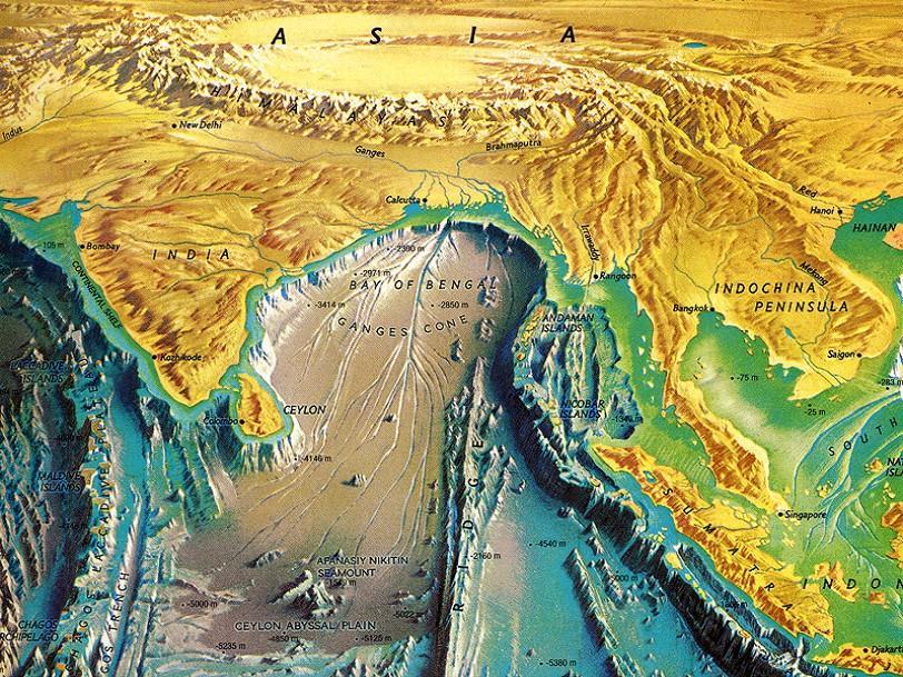
3 Bangladesh
 WATER: 13,660 sq km (10%) Sunderban Highlands at southeastern and northeastern part Max")
4 Country at a Glance Physical Features 1,230 m TOTAL AREA: 147,570 sq km LAND: 133,910 sq km (90%) WATER: 13,660 sq km (10%) Sunderban Highlands at southeastern and northeastern part Max Height

5 Bangladesh receive runoff from a catchment of 1.72 million sq-km, around 12 times of its land area Brahmaputra Basin 552,000 sq-km C H I N A Ganges Basin 1,087,000 sq-km BHUTAN I N D I A I N D I A BANGLADESH Meghna Basin 82,000 sqkm B A Y O F B E N G A L 5
6 Impact Channel of Climate Change Erratic rainfall Temperature rise Sea level rise and salinity intrusion Rise of extreme climatic events : flood frequency cyclone and storm surges droughts
7 Jun_01 Jun_05 Jun_09 Jun_13 Jun_17 Jun_21 Jun_25 Jun_29 Jul_03 Jul_07 Jul_11 Jul_15 Jul_19 Jul_23 Jul_27 Jul_31 Aug_04 Aug_08 Aug_12 Aug_16 Aug_20 Aug_24 Aug_28 Sep_01 Sep_05 Sep_09 Sep_13 Sep_17 Sep_21 Sep_25 Sep_29 Rainfall in mm Rainfall in mm Rainfall Pattern of Bangladesh Normal Rainfall in different months over Bangladesh Daily average monsoon rainfall modal value is 20.6 mm on 16 June and 21.1 mm on 10 July. The intra seasonal variation is 5-7 days with the changing value of 3-5 mm JAN FEB MAR APR MAY JUN JUL AUG SEP OCT NOV DEC Months Day


8 IWFM, BUET, 2011 Rainfall Trend in Bangladesh
9 Rainfall (mm) Rainfall (mm) Rainfall (mm) Rainfall (mm) Seasonal Variation of Rainfall in Bangladesh y = x R 2 = y = x R 2 = Year Pre-Monsoon M onsoon_c Monsoon Year y = x R 2 = y = x R 2 = Post -Monsoon_C Year Winter_C Year Post-Monsoon Winter
10 Rainfall (mm) Over All Bangladesh y = 1.993x R 2 = Yearly_C Year Variation of Yearly Rainfall
11 Total Rainfall in mm Variation of Yearly Rainfall in Dhaka y = x R 2 = Year Yearly Variation of Yearly Rainfall

12 Spatial rainfall distribution of Bangladesh
13 Temperature Trend in Bangladesh Almost all the stations exhibit increasing trends in mean annual temperatures, C per century (100 years); Increase in winter (December- February) C IWFM, BUET, 2011
14 Seasonal Variation of Mean Temperature in Bangladesh Pre-Monsoon Monsoon Post-Monsoon Winter

15 Flood Bangladesh is facing floods almost every year due to heavier rainfall inside and outside the country. Major flood occurred from 1970 to 2009, but the frequency of major flood occurrenc has increased since million people have been displaced by floods since In 2000, about 3 million people became homeless due to inundation of 5 coastal districts. In 2004, 39 districts were affected, leaving 36 million people homeless.
 (33")
16 Flooded Area from 1954 to 2011 twice during period (55 & 74) (33 years) 16
17 Water Level (mpwd) Flood in Bangladesh 21 Jamuna River at Bahadurabad Jan 19-Feb 9-Apr 29-May 18-Jul 6-Sep 26-Oct 15-Dec Danger Level Recorde Highest WL

18 Impact of Climate Change on Salinity Intrusion (5ppt Salinity line) Khulna Barisal Sundarbans Hiron Point Barguna Patuakhali 55 km 95 km Bhola 0 SLR 60 cm SLR 120 cm SLR


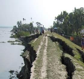
19 River Erosion in Jamuna During the last three decades. The Jamuna, Ganges and Meghna rivers have consumed about 180,000 ha land.

20 Inundation Risk Map Coastal Area 1 m Line 3 m Line 6 m Line
21 Climate change impacts in Bangladesh Cyclone/storm surge: increased frequency & intensity, increasing salinity Flood: increased frequency & magnitude Droughts: Spreading over time and space Erratic rainfall: Intensive rain in short time Temperature: extremely increasing Riverbank and coastal erosion: increasing Water logging and permanent inundation due to SLR


22 Drought Cyclone Storm surge, salinity Hazards Bangladesh faces Flood Water logging River Bank Erosion Bank erosion

23 Drought, Floods, Cyclones likely to increase in future due to climate change. Disaster risk reduction strategy need strengthening.

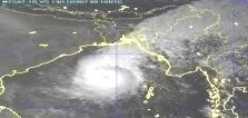
24 Cyclone From 1970 to 2009, the total number of major cyclones stroked Bangladesh was ,000 people and 70,000 cattle died in 1991 cyclone. Loss of property was estimated at about Tk 60 billion. Cyclone Sidr, displaced 650,000 people and killed 3,447. In the year 2009, about 200,000 people were displaced by cyclone Bijli.

25 Drought Drought is another severe natural phenomenon which causes disastrous crop failures.
26 Critical and Specific Issues River Flood River Bank Erosion Flash Flood. Surge height >1m Surge height <1m Drought

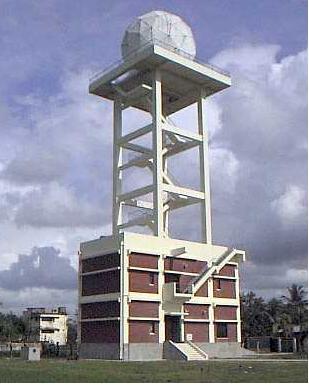
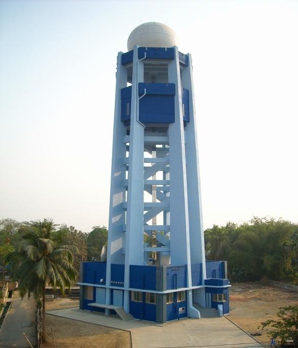
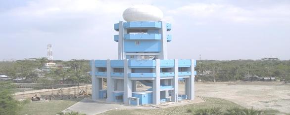
27 Observational Facilities of BMD a. Synoptic observatories : 35 b. Pilot Observatories : 10 c. Rawinsonde Observatories : 3 d. Agromet observatories : 12 e. RADAR Stations : 5 f. Earthquake Monitoring Stations: 4 Synoptic Observatory Pilot Balloon Observatory Rawinsonde Observatory Agromet Observatory

 Cox s Bazar")
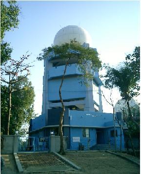
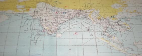
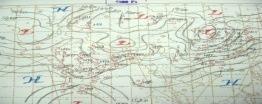
28 Radar Network of BMD BMD Radar network have good coverage over Bangladesh and its surrounding areas. Radar location Khepupara (Doppler) Cox s Bazar (Doppler) Dhaka Rangpur Moulvibazar (Doppler)


29 VSAT Antenna Moulvibazar Radar Khepupara Radar Dhaka Radar Cox s Bazar Radar Rangpur Radar

30 Satellite Receiving Stations BMD has the following satellite receiving ground stations: MTSAT NOAA MICAPS
31 JICA s Contribution to BMD JICA is helping BMD for the installation and maintenance of its infrastructure, communication link, Automatic Weather Station at airport, Satellite Receiving System, On line TV presentation, National microwave and VSAT link connectivity for radar stations to get digital radar image Preparation of composite radar picture at the Storm Warning Centre Human capacity building both in meteorology and seismology.


32 Forecasting Technique of BMD Rain cloud Cloud image Rainfall etc. Upper air data Ground data Temp. Wind Air pressure Rainfall etc. Computer Prediction Television. Radio. News paper. Telephone. Fax. Web page.
33 BANGLADESH SPACE RESEARCH AND REMOTE SENSING ORGANIZATION (SPARRSO) Established in 1980 Acts for peaceful applications of space science, Remote Sensing and Geographic Information System (GIS) in Bangladesh. Advises the Government in matters relating to space technology applications and policy. Keeps close collaboration with national, regional and international organizations, institutions and agencies. Disseminates research results, satellite data and information to the relevant public, autonomous and private agencies for their development and policy making activities.
34 Activities of SPARRSO Agricultural research Disaster monitoring Environment study Forestry Fisheries Water resources Oceanography, Coastal environment study etc

35 Digital Mapping Project in Survey of Bangladesh - Assisted by JICA Preparation of 988 Digital Maps of 1:25000 scale for entire Bangladesh. Preparation of 263 Digital Maps of 1:5000 scale for 5 Divisional cities. Preparation of ortho photo Map of Bangladesh. Preparation of Elevation data of Bangladesh. Digital Mapping will be completed by 2016.
36 Conclusion Regional and international cooperation and coordination along with structural and non-structural measures is essential for mitigation or reduction of disasters and hazards of flood 36

37
EFFECTIVE TROPICAL CYCLONE WARNING IN BANGLADESH
 Country Report of Bangladesh On EFFECTIVE TROPICAL CYCLONE WARNING IN BANGLADESH Presented At JMA/WMO WORKSHOP ON EFFECTIVE TROPICAL CYCLONE WARNING IN SOUTHEAST ASIA Tokyo, Japan,11-14 March 2014 By Sayeed
Saiful Islam Anisul Haque
 Workshop on Disaster Prevention/Mitigation Measures against Floods and Storm Surges in Bangladesh on 17-21 November, 2012, in Kyoto University, Japan Component 2: Flood disaster risk assessment and mitigation
Country Presentation-Nepal
 Country Presentation-Nepal Mt.Everest, Shiva Pd. Nepal, DHM South Asia Drought Monitor Workshop Dhaka Bangladesh 2 th April 215 Overview Brief Climatology Climate activities- DHM PPCR (Pilot Program for
Analysis of Historical Pattern of Rainfall in the Western Region of Bangladesh
 24 25 April 214, Asian University for Women, Bangladesh Analysis of Historical Pattern of Rainfall in the Western Region of Bangladesh Md. Tanvir Alam 1*, Tanni Sarker 2 1,2 Department of Civil Engineering,
JCOMM-CHy Coastal Inundation Forecasting Demonstration Project (CIFDP)
") WMO World Meteorological Organization Working together in weather, climate and water JCOMM-CHy Coastal Inundation Forecasting Demonstration Project (CIFDP) Coastal Flooding & Vulnerable Populations Coastal
WMO World Meteorological Organization Working together in weather, climate and water JCOMM-CHy Coastal Inundation Forecasting Demonstration Project (CIFDP) Coastal Flooding & Vulnerable Populations Coastal
National Report on Weather Forecasting Service
 MINISTRY OF WATER RESOURCES AND METEOROLOGY DEPARTMENT OF METEOROLOGY, CAMBODIA National Report on Weather Forecasting Service Tokyo, 11-15 March 2014 Department of Meteorology, Cambodia Presentation Outline
Sri Lanka Enhancing the Role of ICTs for Disaster Risk Management
 Workshop on ICT for Promoting Inclusive and Disaster Resilient Development Ulaanbaatar, Mongolia Sri Lanka Enhancing the Role of ICTs for Disaster Risk Management Kanchana Thudugala Programme Head, eservices
COUNTRY REPORT. Jakarta. July, th National Directorate of Meteorology and Geophysics of Timor-Leste (DNMG)
") The Southeastern Asia-Oceania Flash Flood COUNTRY REPORT Jakarta. July, 10-12 th 2017 National Directorate of Meteorology and Geophysics of Timor-Leste (DNMG) Carla Feritas and Crisostimo Lobato Democratic
The Southeastern Asia-Oceania Flash Flood COUNTRY REPORT Jakarta. July, 10-12 th 2017 National Directorate of Meteorology and Geophysics of Timor-Leste (DNMG) Carla Feritas and Crisostimo Lobato Democratic
Flood Forecasting in Bangladesh
 Flood Forecasting in Bangladesh Types of Flood ing Flood ing can be divided into two categories: Flood ing in the rivers caused by upstream rise of river stage as well as rainfall in the basin. Overland
Decadal Changes of Rainfall and Temperature Extremes over the different Agro Economical Zones (AEZ) of Bangladesh
 of Bangladesh") Decadal Changes of Rainfall and Temperature Extremes over the different Agro Economical Zones (AEZ) of Bangladesh Professor A.K.M. Saiful Islam Md. Alfi Hasan Institute of Water and Flood Management Bangladesh
Decadal Changes of Rainfall and Temperature Extremes over the different Agro Economical Zones (AEZ) of Bangladesh Professor A.K.M. Saiful Islam Md. Alfi Hasan Institute of Water and Flood Management Bangladesh
Tropics: Weather Forecasting And Early Warning System in Bangladesh.
 Regional Workshop on Impact-based Forecast in RA II (Asia) 07-09,November 2017 Seoul, Republic of Korea. Tropics: Weather Forecasting And Early Warning System in Bangladesh. Md. Sanaul Hoque Mondal Assistant
Early Warning System and Role of IMD. Manmohan Singh Meteorological Centre Shimla
 Early Warning System and Role of IMD Manmohan Singh Meteorological Centre Shimla India a land with a unique climatic regime Two monsoon seasons (southwest & northeast monsoons) Two cyclone seasons (pre
JICA s Cooperation for NMHSs. Taisuke Watanabe Japan International Cooperation Agency
 JICA s Cooperation for NMHSs Taisuke Watanabe 28 Oct, 2014 JICA s Assistant Approach for Hydrological and Meteorological Services Assistance for improvement of Hydrological and Meteorological Services
Impact of Climate Change on Riverbank Erosion
 International Journal of Sciences: Basic and Applied Research (IJSBAR) ISSN 2307-4531 http://gssrr.org/index.php?journal=journalofbasicandapplied Impact of Climate Change on Riverbank Erosion Most. Nazneen
CORRELATION BETWEEN TEMPERATURE CHANGE AND EARTHQUAKE IN BANGLADESH
 CORRELATION BETWEEN TEMPERATURE CHANGE AND EARTHQUAKE IN BANGLADESH A. Hossain *, F. Kabir & K. Roy Department of Civil Engineering, Rajshahi University of Engineering & Technology, Rajshahi, Bangladesh
Chiang Rai Province CC Threat overview AAS1109 Mekong ARCC
 Chiang Rai Province CC Threat overview AAS1109 Mekong ARCC This threat overview relies on projections of future climate change in the Mekong Basin for the period 2045-2069 compared to a baseline of 1980-2005.
Role of Hydro-Met Services in Disaster Risk Management
 Role of Hydro-Met Services in Disaster Risk Management Tshewang Rigzin (Mr) National Centre for Hydrology and Meteorology, Bhutan 30 th November 2017 Outline Vision and Mission Functions related to Disaster
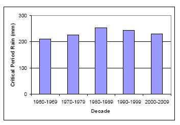
Analysis of the Extreme Rainfall Indices over Bangladesh
 INTERNATIONAL CLIMATE CHANGE SYMPOSIUM-2015: Impacts of Extreme Atmospheric Events on Geo-surface in a Changing Climate Environmental Technology Section, Industrial technology Institute (ITI) 14th 15th
Flood Inundation Mapping under different climate change scenarios in the upper Indus River Basin, Pakistan
 Flood Inundation Mapping under different climate change scenarios in the upper Indus River Basin, Pakistan Sohaib Baig (doctoral student) 16 November 2017 Disaster Prevention Research Institute 1 Kyoto
Introduction to the Science of Climate Change
 Climate Change Capacity Building Program for Journalists March 28-29, 2016, Asia Pacific Hotel - Road 2, House 2, Baridhara, Introduction to the Science of Climate Change Dr. A.K.M. Saiful Islam Professor
IMPACT OF CLIMATE CHANGE ON RAINFALL INTENSITY IN BANGLADESH
 IMPACT OF CLIMATE CHANGE ON RAINFALL INTENSITY IN BANGLADESH Sonia Binte Murshed 1 *, AKM Saiful Islam 2 and M.Shah Alam Khan 3 1 Lecturer, IWFM, BUET, Dhaka-1000, Email: sonia@iwfm.buet.ac.bd 2 Associtae
On the presence of tropical vortices over the Southeast Asian Sea- Maritime Continent region
 Technical Conference of 50 th Annual Session of Typhoon Committee 2018 On the presence of tropical vortices over the Southeast Asian Sea- Maritime Continent region Nguyen Dang-Quang 1, James Renwick 2,
Available online Journal of Scientific and Engineering Research, 2018, 5(3): Research Article
: Research Article") Available online www.jsaer.com, 2018, 5(3):166-180 Research Article ISSN: 2394-2630 CODEN(USA): JSERBR Impact of Climate Variability on Human Health- A Case Study at Kanchanpur Union, Basail, Tangail District,
Available online www.jsaer.com, 2018, 5(3):166-180 Research Article ISSN: 2394-2630 CODEN(USA): JSERBR Impact of Climate Variability on Human Health- A Case Study at Kanchanpur Union, Basail, Tangail District,
Government of Sultanate of Oman Public Authority of Civil Aviation Directorate General of Meteorology. National Report To
 Government of Sultanate of Oman Public Authority of Civil Aviation Directorate General of Meteorology National Report To Panel on Tropical Cyclones in the Bay of Bengal And Arabian Sea 43rd Session, India
Use of Climate information in Disaster Risk Management in Zimbabwe
 Use of Climate information in Disaster Risk Management in Zimbabwe WMO Regional Technical Meeting & User/CONOPS Workshop, 28 th October 2015 Lameck Betera Department of Civil Protection Institutional Arrangements
Recent development of the National Hydro-Meteorological Service (NHMS) of Viet Nam for disaster risk reduction
 of Viet Nam for disaster risk reduction") Ministry of Natural Resources and Environment National Hydro-Meteorological Service Recent development of the National Hydro-Meteorological Service (NHMS) of Viet Nam for disaster risk reduction Tran Van
Ministry of Natural Resources and Environment National Hydro-Meteorological Service Recent development of the National Hydro-Meteorological Service (NHMS) of Viet Nam for disaster risk reduction Tran Van
Theme 4. Disaster Mitigation and Risk Management
 Theme 4 Disaster Mitigation and Risk Management World Flood Map in 2002 Released by WMO as of August 29 Over 17 million were affected (in more than 80 countries) 3,000 were killed Total damage of over
Application of Satellite Data for Flood Forecasting and Early Warning in the Mekong River Basin in South-east Asia
 MEKONG RIVER COMMISSION Vientiane, Lao PDR Application of Satellite Data for Flood Forecasting and Early Warning in the Mekong River Basin in South-east Asia 4 th World Water Forum March 2006 Mexico City,
Japanese Programs on Space and Water Applications
 Japanese Programs on Space and Water Applications Tamotsu IGARASHI Remote Sensing Technology Center of Japan June 2006 COPUOS 2006 Vienna International Centre Water-related hazards/disasters may occur
Study of Hydrometeorology in a Hard Rock Terrain, Kadirischist Belt Area, Anantapur District, Andhra Pradesh
 Open Journal of Geology, 2012, 2, 294-300 http://dx.doi.org/10.4236/ojg.2012.24028 Published Online October 2012 (http://www.scirp.org/journal/ojg) Study of Hydrometeorology in a Hard Rock Terrain, Kadirischist
Climate also has a large influence on how local ecosystems have evolved and how we interact with them.
 The Mississippi River in a Changing Climate By Paul Lehman, P.Eng., General Manager Mississippi Valley Conservation (This article originally appeared in the Mississippi Lakes Association s 212 Mississippi
WEATHER AND CLIMATE EXTREMES MONITORING BASED ON SATELLITE OBSERVATION : INDONESIA PERSPECTIVE RIRIS ADRIYANTO
 WEATHER AND CLIMATE EXTREMES MONITORING BASED ON SATELLITE OBSERVATION : INDONESIA PERSPECTIVE RIRIS ADRIYANTO INDONESIA AGENCY FOR METEOROLOGY, CLIMATOLOGY AND GEOPHYSICS (BM KG) 1. INTRODUCTION - BMKG
Applications of Space Technology and GIS for Disaster Risk Reduction and Sustainable Development in Myanmar
 Applications of Space Technology and GIS for Disaster Risk Reduction and Sustainable Development in Myanmar Ms. Tin Yi Deputy Director Department of Meteorology and Hydrology MYANMAR Natural hazards Meteorological
Coastal Inundation Forecasting Demonstration Project CIFDP. Flood Forecasting Initiative-Advisory Group (FFI-AG 3), Geneva, 5-7 Dec, 2017
, Geneva, 5-7 Dec, 2017") Coastal Inundation Forecasting Demonstration Project CIFDP Flood Forecasting Initiative-Advisory Group (FFI-AG 3), Geneva, 5-7 Dec, 2017 Coastal Flooding & Vulnerable Populations Coastal populations are
Coastal Inundation Forecasting Demonstration Project CIFDP Flood Forecasting Initiative-Advisory Group (FFI-AG 3), Geneva, 5-7 Dec, 2017 Coastal Flooding & Vulnerable Populations Coastal populations are
Republic of Mozambique
 Republic of Mozambique Second Expert's Symposium on Multi-Hazard Early Warning Systems with focus on the Role of National Meteorological and Hydrological Services 5-7 May 2009, Toulouse France 1. Background
CLIMATE CHANGE ADAPTATION BY MEANS OF PUBLIC PRIVATE PARTNERSHIP TO ESTABLISH EARLY WARNING SYSTEM
 CLIMATE CHANGE ADAPTATION BY MEANS OF PUBLIC PRIVATE PARTNERSHIP TO ESTABLISH EARLY WARNING SYSTEM By: Dr Mamadou Lamine BAH, National Director Direction Nationale de la Meteorologie (DNM), Guinea President,
Use of Geospatial data for disaster managements
 Use of Geospatial data for disaster managements Source: http://alertsystemsgroup.com Instructor : Professor Dr. Yuji Murayama Teaching Assistant : Manjula Ranagalage What is GIS? A powerful set of tools
Final Report. COMET Partner's Project. University of Texas at San Antonio
 Final Report COMET Partner's Project University: Name of University Researcher Preparing Report: University of Texas at San Antonio Dr. Hongjie Xie National Weather Service Office: Name of National Weather
United States Multi-Hazard Early Warning System
 United States Multi-Hazard Early Warning System Saving Lives Through Partnership Lynn Maximuk National Weather Service Director, Central Region Kansas City, Missouri America s s Weather Enterprise: Protecting
HEAVY RAIN OVER MID-CENTRAL REGION OF VIETNAM
 HEAVY RAIN OVER MID-CENTRAL REGION OF VIETNAM ----------------------------------------------------------------------- S.Eng. Dang Thi Mai; Dr. Nguyen Thi Tan Thanh National Hydro Meteorological Service
Chapter-3 GEOGRAPHICAL LOCATION, CLIMATE AND SOIL CHARACTERISTICS OF THE STUDY SITE
 Chapter-3 GEOGRAPHICAL LOCATION, CLIMATE AND SOIL CHARACTERISTICS OF THE STUDY SITE Chapter-3 GEOGRAPHICAL LOCATION, CLIMATE AND SOIL CHARACTERISTICS OF THE STUDY SITE Assam, the eastern most state of
Climate Change in Bangladesh: A Historical Analysis of Temperature and Rainfall Data
 Research Paper Climate Change in Bangladesh: A Historical Analysis of Temperature and Rainfall Data Jayanta Kumar Basak 1 *, Rashed Al Mahmud Titumir 2 and Nepal Chandra Dey 3 1 Dept. of Environmental
OVERVIEW OF IMPROVED USE OF RS INDICATORS AT INAM. Domingos Mosquito Patricio
 OVERVIEW OF IMPROVED USE OF RS INDICATORS AT INAM Domingos Mosquito Patricio domingos.mosquito@gmail.com Introduction to Mozambique /INAM Introduction to AGRICAB/SPIRITS Objectives Material & Methods Results
Management in Surface, Climate and Upper-air Observations in RAII,Tokyo, Assistant Director Bangladesh Meteorological Department
 JMA / WMO Workshop on Quality Management in Surface, Climate and Upper-air Observations in RAII,Tokyo, 27-30 July 2010 Shamsuddin Ahmed Assistant Director Bangladesh Meteorological Department Bangladesh
Coastal Inundation Forecasting and Community Response in Bangladesh
 WMO Coastal Inundation Forecasting and Community Response in Bangladesh Bapon (SHM) Fakhruddin Nadao Kohno 12 November 2015 System Design for Coastal Inundation Forecasting CIFDP-PSG-5, 14-16 May 2014,
investment decisions
 Climate modelling: A guide to investment decisions Vicky Pope Met Office Hadley Centre This is not an ADB material. The views expressed in this document are the views of the author/s and/or their organizations
Regional Flash Flood Guidance and Early Warning System
 WMO Training for Trainers Workshop on Integrated approach to flash flood and flood risk management 24-28 October 2010 Kathmandu, Nepal Regional Flash Flood Guidance and Early Warning System Dr. W. E. Grabs
Enhancing Preparedness and Early Warning in Disaster Risk Reduction
 Enhancing Preparedness and Early Warning in Disaster Risk Reduction Fifth Technical Conference on Management of Meteorological and Hydrological Services in Regional Association V at PETALING JAYA, MALAYSIA
Community-Based Flood Early Warning System (CBFEWS)
") Community-Based Flood Early Warning System (CBFEWS) Prepared by: Eng r. Hilario G. Esperanza Eng r.. Socrates F. Paat,, Jr. Flood Forecasting Branch PAGASA Weather Bureau Department of Science and Technology
Community-Based Flood Early Warning System (CBFEWS) Prepared by: Eng r. Hilario G. Esperanza Eng r.. Socrates F. Paat,, Jr. Flood Forecasting Branch PAGASA Weather Bureau Department of Science and Technology
Overview of existing Weather Forecasting and Warning infrastructures in Myanmar
 Overview of existing Weather Forecasting and Warning infrastructures in Myanmar by Dr. Zin Mie Mie Sein Officer (DMH) 26. February. 2018 Nay Pyi Taw Outline Introduction Myanmar & its disasters Meteorological
Smart use of Geographic Information System (GIS) platform for delivering weather information and nowcasting services
 platform for delivering weather information and nowcasting services") Smart use of Geographic Information System (GIS) platform for delivering weather information and nowcasting services C. K. Pan Hong Kong Observatory Hong Kong, China It is a world of beauty Source: Image
Smart use of Geographic Information System (GIS) platform for delivering weather information and nowcasting services C. K. Pan Hong Kong Observatory Hong Kong, China It is a world of beauty Source: Image
BASIC DESIGN STUDY REPORT
 NO. BASIC DESIGN STUDY REPORT ON THE PROJECT FOR IMPROVEMENT OF THE METEOROLOGICAL RADAR SYSTEMS AT COX S BAZAR AND KHEPUPARA IN THE PEOPLE S REPUBLIC OF BANGLADESH MAY, 2005 JAPAN INTERNATIONAL COOPERATION
Satellite-based applications for water resources management in Asia and Pacific region
 Satellite-based applications for water resources management in Asia and Pacific region Ko Hamamoto Japan Aerospace Exploration Agency The views expressed in this paper/presentation are the views of the
Caribbean Early Warning System Workshop
 Caribbean Early Warning System Workshop Hamonization in Existing EWS April 14-16, 2016 Presenter: Shawn Boyce Caribbean Institute for Meteorology and Hydrology Husbands, St. James Barbados Background Between
Effective Utilization of Synthetic Aperture Radar (SAR) Imagery in Rapid Damage Assessment
 Imagery in Rapid Damage Assessment") Effective Utilization of Synthetic Aperture Radar (SAR) Imagery in Rapid Damage Assessment Case Study Pakistan Floods SUPARCO M. Maisam Raza, Ahmad H. Rabbani SEQUENCE Flood Monitoring using Satellite
Effective Utilization of Synthetic Aperture Radar (SAR) Imagery in Rapid Damage Assessment Case Study Pakistan Floods SUPARCO M. Maisam Raza, Ahmad H. Rabbani SEQUENCE Flood Monitoring using Satellite
Meteorological alert system in NMS of Mongolia
 Meteorological alert system in NMS of Mongolia L.Oyunjargal, NAMEM Regional Workshop on Impact-based Forecasts in Asia Seoul, Korea, 07-09 NOV 2017 Weather related disasters 1. Strong wind and snow and
International Flood Network - IFNet
 International Flood Network - IFNet - Akira Sasaki Deputy Director General IFNet Secretariat Today s s Contents 1. IFNet (International Flood Network) 2. GFAS (Global Flood Alert System) Increasing Flood
Progress Report. Flood Hazard Mapping in Thailand
 Progress Report Flood Hazard Mapping in Thailand Prepared By: Mr. PAITOON NAKTAE Chief of Safety Standard sub-beuro Disaster Prevention beuro Department of Disaster Prevention and Mitigation THAILAND E-mail:
HYDRO-METEOROLOGICAL INVESTIGATION OF 2015 FLASH FLOOD IN EASTERN HILL BASIN BANGLADESH
 HYDRO-METEOROLOGICAL INVESTIGATION OF 2015 FLASH FLOOD IN EASTERN HILL BASIN BANGLADESH M.S. Hossain 1*, G. M. T. Islam 2, S. U. Raihan 1, S. M. Q. Hassan 3 & R. H. Khan 4 1 Flood Forecasting and Warning
Mainstream Space Technology in Implementing SFDRR - GPSTAR. Srimal Samansiri Disaster Management Centre Government of Sri Lanka
 Mainstream Space Technology in Implementing SFDRR - GPSTAR Srimal Samansiri Disaster Management Centre Government of Sri Lanka SFDRR Priority Actions Effective use of Space technology in SFDRR Priority
Improving global coastal inundation forecasting WMO Panel, UR2014, London, 2 July 2014
 Improving global coastal inundation forecasting WMO Panel, UR2014, London, 2 July 2014 Cyclone Sidr, November 2007 Hurricane Katrina, 2005 Prof. Kevin Horsburgh Head of marine physics, UK National Oceanography
The Huong River the nature, climate, hydro-meteorological issues and the AWCI demonstration project
 The Huong River the nature, climate, hydro-meteorological issues and the AWCI demonstration project 7th GEOSS AP Symposium, the AWCI parallel session May 27, 214, Tokyo National Centre for Hydro-Meteorological
Country Report: Bangladesh
 The 5th International Coordination Group (ICG) Meeting GEOSS Asian Water Cycle Initiative (AWCI) Tokyo, Japan, 15-18, December 2009 Country Report: Bangladesh Monitoring and forecasting of cyclones SIDR
HISTORY OF HEAVY RAINFALL DISASTER INFORMATION IN JAPAN
 transmission, for a state-of-the-art review. In addition, issues expected to arise in the future are discussed. HISTORY OF HEAVY RAINFALL DISASTER INFORMATION IN JAPAN Progress of Rainfall Observation
WHEN IS IT EVER GOING TO RAIN? Table of Average Annual Rainfall and Rainfall For Selected Arizona Cities
 WHEN IS IT EVER GOING TO RAIN? Table of Average Annual Rainfall and 2001-2002 Rainfall For Selected Arizona Cities Phoenix Tucson Flagstaff Avg. 2001-2002 Avg. 2001-2002 Avg. 2001-2002 October 0.7 0.0
EARLY WARNING IN SOUTHERN AFRICA:
 EARLY WARNING IN SOUTHERN AFRICA: Enhancing the Meteorological Early Warning System Eugene Poolman South African Weather Service OUTLINE OF PRESENTATION Impact of Climate Change Meteorological Early Warning
Tokyo, Japan March Discussed By: May Khin Chaw, Kyaw Lwin Oo. Department of Meteorology and Hydrology
 Tokyo, Japan 11-14 March 2014 Discussed By: May Khin Chaw, Kyaw Lwin Oo Department of Meteorology and Hydrology Manpower: Out of DMH s total (1425), we are Working with (780) Staffs. 55% (37) stations
Impact of Tropical Cyclones - Malaysia's Experience
 Impact of Tropical Cyclones - Malaysia's Experience ALUI BAHARI MALAYSIAN METEOROLOGICAL DEPARTMENT MINISTRY OF SCIENCE, TECHNOLOGY AND INNOVATION SCOPE Introduction Case Studies of Tropical Cyclones Impacting
Ms. Latoya Regis. Meteorologist Hydrometeorological Service, Guyana
 Ms. Latoya Regis Meteorologist Hydrometeorological Service, Guyana Background Ninety percent (90%) of Guyana s population resides along the (Atlantic) Coast, which is below mean sea level and accounts
2015 Fall Conditions Report
 2015 Fall Conditions Report Prepared by: Hydrologic Forecast Centre Date: December 21 st, 2015 Table of Contents Table of Figures... ii EXECUTIVE SUMMARY... 1 BACKGROUND... 2 SUMMER AND FALL PRECIPITATION...
Implications of Climate Change on Long Lead Forecasting and Global Agriculture. Ray Motha
 Implications of Climate Change on Long Lead Forecasting and Global Agriculture Ray Motha Source: http://www.coaps.fsu.edu/lib/climatoons/toon38.shtml ENSO Teleconnections 30 Observed Monthly Sea Surface
Activities Related to Disaster Management for Earthquake In Bangladesh
 Activities Related to Disaster Management for Earthquake In Bangladesh I. ABSTRACT Ms. Suraiya Begum & Md. Shah Alam, Principal Scientific Officer, Bangladesh Space Research & Remote Sensing Organization
10 emergency observation requests were successfully processed during the period
 ISRO s Inputs for the Sentinel Asia DPN and JPT meeting being held during 13-16, 16, November 2012 November 2012 Sentinel Asia Activity Spectrum - A dedicated Sentinel Asia server established at NRSC,
US Drought Status. Droughts 1/17/2013. Percent land area affected by Drought across US ( ) Dev Niyogi Associate Professor Dept of Agronomy
 Dev Niyogi Associate Professor Dept of Agronomy") Droughts US Drought Status Dev Niyogi Associate Professor Dept of Agronomy Deptof Earth Atmospheric Planetary Sciences Indiana State Climatologist Purdue University LANDSURFACE.ORG iclimate.org climate@purdue.edu
Droughts US Drought Status Dev Niyogi Associate Professor Dept of Agronomy Deptof Earth Atmospheric Planetary Sciences Indiana State Climatologist Purdue University LANDSURFACE.ORG iclimate.org climate@purdue.edu
CATCHMENT DESCRIPTION. Little River Catchment Management Plan Stage I Report Climate 4.0
 CATCHMENT DESCRIPTION Little River Catchment Management Plan Stage I Report Climate 4. Little River Catchment Management Plan Stage I Report Climate 4.1 4. CLIMATE 4.1 INTRODUCTION Climate is one of the
Flash Flood Flash Flood Forecasting and Early Warning System (FFEWS)
") Stakeholder Workshop of Haor Area Livelihoods Improvement Project (HALIP) 15 January 2016, Sunamganj, Bangladesh Flash Flood Flash Flood Forecasting and Early Warning System (FFEWS) BUET Study Team Prof
Stakeholder Workshop of Haor Area Livelihoods Improvement Project (HALIP) 15 January 2016, Sunamganj, Bangladesh Flash Flood Flash Flood Forecasting and Early Warning System (FFEWS) BUET Study Team Prof
ANNOUNCEMENT WMO/ESCAP PANEL ON TROPICAL CYCLONES THIRTY-EIGHTH SESSION NEW DELHI, INDIA
 WMO IMD ESCAP ANNOUNCEMENT THIRTY-EIGHTH SESSION NEW DELHI, INDIA (21-25 February 2011) HISTORICAL BACKGROUND The tropical cyclones are particularly severe in the north Indian Ocean region. The northern
GAMINGRE 8/1/ of 7
 FYE 09/30/92 JULY 92 0.00 254,550.00 0.00 0 0 0 0 0 0 0 0 0 254,550.00 0.00 0.00 0.00 0.00 254,550.00 AUG 10,616,710.31 5,299.95 845,656.83 84,565.68 61,084.86 23,480.82 339,734.73 135,893.89 67,946.95
Understanding Weather and Climate Risk. Matthew Perry Sharing an Uncertain World Conference The Geological Society, 13 July 2017
 Understanding Weather and Climate Risk Matthew Perry Sharing an Uncertain World Conference The Geological Society, 13 July 2017 What is risk in a weather and climate context? Hazard: something with the
Commercialisation. Lessons learned from Dutch weather market
 Commercialisation Lessons learned from Dutch weather market Where information comes together weather traffic public transport Weather, traffic and public transport. Daily actual information that influences
Rainfall Observations in the Loxahatchee River Watershed
 Rainfall Observations in the Loxahatchee River Watershed Richard C. Dent Loxahatchee River District September 1997 Introduction Rain is a common occurrence in south Florida, yet its presence or absence
Emerging Needs, Challenges and Response Strategy
 Emerging Needs, Challenges and Response Strategy Development of Integrated Observing Systems in China JIAO Meiyan Deputy Administrator China Meteorological Administration September 2011 Geneva Outline
Flash Flood Guidance System On-going Enhancements
 Flash Flood Guidance System On-going Enhancements Hydrologic Research Center, USA Technical Developer SAOFFG Steering Committee Meeting 1 10-12 July 2017 Jakarta, INDONESIA Theresa M. Modrick Hansen, PhD
Joint Meeting of RA II WIGOS Project and RA V TT-SU on 11 October 2018 BMKG Headquarter Jakarta, Indonesia. Mrs. Sinthaly CHANTHANA
 Joint Meeting of RA II WIGOS Project and RA V TT-SU on 11 October 2018 BMKG Headquarter Jakarta, Indonesia Mrs. Sinthaly CHANTHANA Lao PDR Background Department of Meteorology and Hydrology ( DMH ) in
Funding provided by NOAA Sectoral Applications Research Project CLIMATE. Basic Climatology Colorado Climate Center
 Funding provided by NOAA Sectoral Applications Research Project CLIMATE Basic Climatology Colorado Climate Center Remember These? Factor 1: Our Energy Source Factor 2: Revolution & Tilt Factor 3: Rotation!
The Case of the El Nino
 Page 1 of 5 Reducing the Impact of Environmental Emergencies Through Early Warning and Preparedness The Case of El Niño-Southern Oscillation (ENSO) Home >> Bangladesh Executive Summary Bangladesh Country
Current Climate Trends and Implications
 Current Climate Trends and Implications Dr. Mark Seeley Professor emeritus Department of Soil, Water, and Climate University of Minnesota St Paul, MN 55108 Crop Insurance Conference September 12, 2018
Geospatial application in Kiribati
 Geospatial application in Kiribati ICC-21 ST RESAP (9 TH TO 13 TH OCTOBER, 2017) BANGKOK, THAILAND Outline Kiribati Profile Natural disasters in Kiribati Achievements Challenges/Issues Ways forward 1 Kiribati
Study of Changes in Climate Parameters at Regional Level: Indian Scenarios
 Study of Changes in Climate Parameters at Regional Level: Indian Scenarios S K Dash Centre for Atmospheric Sciences Indian Institute of Technology Delhi Climate Change and Animal Populations - The golden
CHAPTER 13 WEATHER ANALYSIS AND FORECASTING MULTIPLE CHOICE QUESTIONS
 CHAPTER 13 WEATHER ANALYSIS AND FORECASTING MULTIPLE CHOICE QUESTIONS 1. The atmosphere is a continuous fluid that envelops the globe, so that weather observation, analysis, and forecasting require international
Changing Hydrology under a Changing Climate for a Coastal Plain Watershed
 Changing Hydrology under a Changing Climate for a Coastal Plain Watershed David Bosch USDA-ARS, Tifton, GA Jeff Arnold ARS Temple, TX and Peter Allen Baylor University, TX SEWRU Objectives 1. Project changes
Disaster RISK Management : Bhutanese Scenario
 Disaster RISK Management : Bhutanese Scenario Expert Group Meeting (EGM) on Geo-referenced Information Systems for Disaster Risk Management (Geo-DRM) and sustaining the Community of Practice (COP), Bangkok,
Proposal Report On Flood Hazards Mapping Project In Xebangfai River
 Proposal Report On Flood Hazards Mapping Project In Xebangfai River Prepared By Mr. Boualaythong KOUMPHONH Climate Division Department of Meteorology and Hydrology Water Resources and Environment Administration
The known requirements for Arctic climate services
 The known requirements for Arctic climate services based on findings described in STT White paper 8/2015 Johanna Ekman / EC PHORS STT Regional drivers The Arctic region is home to almost four million people
Global Challenges - Partnering with Service Providers. World Meteorological Organization. J. Lengoasa WMO Deputy Secretary-General
 WMO World Meteorological Organization Working together in weather, climate and water Global Challenges - Partnering with Service Providers J. Lengoasa WMO Deputy Secretary-General jlengoasa@wmo.int http://www.wmo.int/pages/gfcs/gfcs_en.html
Climate Change Impact Assessment on Indian Water Resources. Ashvin Gosain, Sandhya Rao, Debajit Basu Ray
 Climate Change Impact Assessment on Indian Water Resources Ashvin Gosain, Sandhya Rao, Debajit Basu Ray Objectives of the Study To quantify the impact of the climate change on the water resources of the
Status & Challengers of Cook Islands GEO DRM. Cook Islands GEO S/GIS History
 Status & Challengers of Cook Islands GEO DRM By Patrick A. ARIOKA Planning & Advisory Officer EMERGENCY MANAGEMENT COOK ISLANDS Cook Islands GEO S/GIS History 1990 NZODA/MFAT trained by Landcare Research
Climate Change and Water Supply Research. Drought Response Workshop October 8, 2013
 Climate Change and Water Supply Research Drought Response Workshop October 8, 2013 DWR Photo Oroville Reservoir, 2009 Talk Overview Expectations History Atmospheric Rivers and Water Supply Current Research
JOINT BRIEFING TO THE MEMBERS. El Niño 2018/19 Likelihood and potential impact
 JOINT BRIEFING TO THE MEMBERS El Niño 2018/19 Likelihood and potential impact CURRENT EL NIÑO OUTLOOK (SEPTEMBER 2018) CPC/IRI ENSO Forecast from September. Red bars denote probability of an El Nino developing
Communicating Climate Change Consequences for Land Use
 Communicating Climate Change Consequences for Land Use Site: Prabost, Skye. Event: Kyle of Lochalsh, 28 th February 28 Further information: http://www.macaulay.ac.uk/ladss/comm_cc_consequences.html Who