GLOS HarborView A mapping mashup that supports recreational boating on the Great Lakes
|
|
|
- Lorraine Webb
- 6 years ago
- Views:
Transcription

1 GLOS HarborView A mapping mashup that supports recreational boating on the Great Lakes David Hart GIS Specialist Aquatic Science Center University of Wisconsin-Madison GLOS Annual Meeting Ann Arbor, Michigan Monday, April 6, 2009

2 Overview of the Presentation Vision Application Future Directions Panorama, McKinley Marina 11/7/06 I drove from Madison to Milwaukee on a beautiful day in early November When I got within 500 yards of Lake Michigan, I entered a fog bank so thick it was hard to figure out where I was.
 There is a wide variety of experience levels in the Great Lakes boating community.")

3 The Current Problem There are over 4 million boats registered in the eight Great Lakes states (approx. one-third of U.S. total) There is a wide variety of experience levels in the Great Lakes boating community. Boaters use a variety of independent (and sometimes insufficient) sources of information to make decisions about when and where to go boating. This can lead to missed opportunities, inefficient trips, and impaired safety.


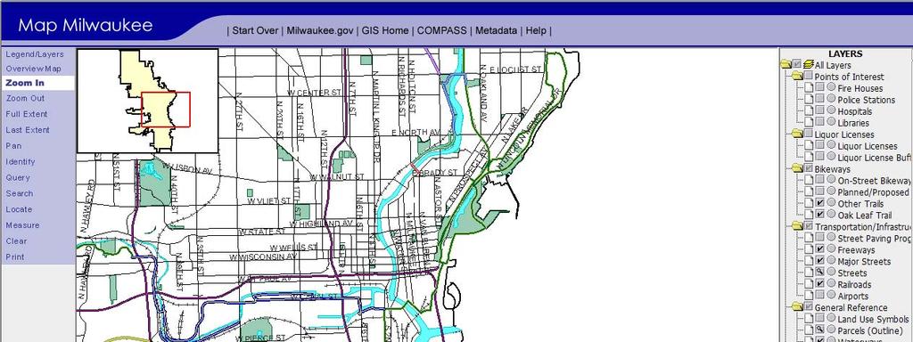
4 What is HarborView? HarborView is a web map viewer focused on Great Lakes harbor communities that seeks to support safe and pleasurable recreational boating. It integrates weather images and coastal observations with maps and info about recreational and cultural attractions.
5 User Needs - Mariner Interviews Interview #1 Milwaukee Yacht Club, 48 Trawler Yacht sails every year in northern Lake Huron active in the Coast Guard Auxiliary keen interest in real-time weather information for the GL What information do you need to help make a decision to go boating? weather (current conditions and forecasts) ports and facilities (destinations) safety and navigation (aids to navigation w/ current status)
6 User Needs - Mariner Interviews What are some of your current sources for this information? Great Lakes Open Lake Forecasts, NWS ( Nautical Charts (buy pre-loaded at West Marine) Coast Pilot, NOAA old school dissemination, but can be downloaded now ( includes aerial photo of harbor Light List, U.S. Coast Guard ( The key question -- Is the light still working today? for example: In Ludington, is the North lighthouse still operating as advertised?
7 User Needs - Mariner Interviews What are some of your current sources for this information? Great Lakes Cruising Guides, Lakeland Boating ( example: Lake Michigan Ports o Call accommodations, sightseeing, emergency, transit, repairs Great Lakes Cruising Club ( membership organization, requires login appoints port captains who prepare harbor reports western shore of Lake Michigan has one report) Michigan Harbor Guide, Michigan DNR way ahead of Wisconsin
8 User Needs - Mariner Interviews General Insights Port facilities info (are there marinas? power supply? where are the nearest services?) Plan trip on availability of dockage can be similar to hotel reservations Visibility and waves are a huge issue for boaters. Boaters are comfortable with zulu time. Wave steepness very important, GL waves have very short, rapid period. Oceans have swells
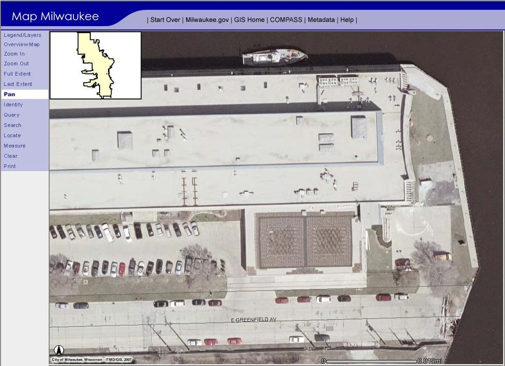
9 User Needs - Mariner Interviews Recommendations for HarborView Prototype Latest obs layer link to NOAA buoy report in dialog box, from buoy report get wave height and period fog, humidity, temperature vs. dew point, wind is critical, barometric pressure ok, water temp Need geo-regulations e.g.) vessels over 40 must go 4 mph in Milwaukee harbor and for 30 minutes before and after fireworks = no wake Need oblique view of harbors e.g.) Pictometry Webcams are becoming very important Regarding integration of information how old is this info? How do boaters get internet access in coastal waters? Help small communities get public wi-fi, should be in all downtowns
10 Balancing User Needs & Technology GLOS application developers discussed several web mapping technology options in April 2008 OpenLayers Flash Chameleon/MapServer The Google Maps API emerged as a good candidate provided a good base map incorporated distributed data sources (KML ) search capabilities It is important to note that web mapping technology is changing very rapidly and we often need to experiment to match the appropriate technology to user needs.
11 HarborView Data Catagories Base Maps nautical charts, orthophotos, topographic maps Satellite Imagery MODIS, NEXRAD reflectivity Model Output wind fields, water level surface, temperature, currents Observations water level stations, buoys, met stations, ships Recreation/Cultural Features boat ramps, lighthouses, parks, beaches, shipwrecks Other webcams, panorama photos, lightning strikes

12 HarborView Initial Screen opens with a basinwide map highlights ~5 harbors on each lake eventually expand to all GL harbors

13 Latest MODIS

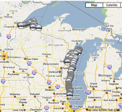
14 Current Precipitation


15 Model Output - Winds


16 Model Output WS Temp

17 Model Output - Currents

18 Select a Harbor
19 Point Observations

20 Latest Observations
21 Webcams

22 GL WATER Institute Webcam

23 GL WATER Institute Webcam Webcam Animation

24

25 Coastal Attractions

26 Lighthouses

27 Terry Pepper Seeing the Light
28 User Generated Content

29 Wikipedia
30 Panoramio
31 Google Local Search
32 Tackle Shops
33 German Restaurants

34 Polish Sausage
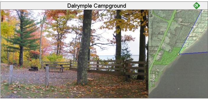
35 Data Sources in the Works Marinas include oblique photos of the harbor entrance Oblique photos Panorama photos of public access sites County and city web mapping sites GeoRSS of cultural events in coastal communities Historic sites Local observatories

36


37
38
39 Future Directions Incremental development bug fixes and performance enhancements scale thresholds and selecting harbors animations Milwaukee prototype usability testing among recreational boaters GLOS awareness and needs survey mapping mashup workshop on each of the lakes Data custodians coastal attractions outside Wisconsin Mobile devices??
40 Questions? David Hart University of Wisconsin Sea Grant Institute Great Lakes Observing System Bill Werick, Chair Jennifer Read, Director Great Lakes Commission staff Roger Gauthier Christine Manninen Guan Wang Devra Polack (Spinster Design) Pete Giencke (now at Google) UW-Madison student Ben Coakley Water is the most critical resource issue of our lifetime and our children's lifetime. The health of our waters is the principal measure of how we live on the land. -Luna Leopold
Great Lakes Information Network GIS (Queryable by topic, geography, organization, and upload date 73 layers as of October, 2009)
") Google Earth Files for the Great Lakes and Beyond GLOS Mapping Workshop Alpena, Michigan November 9, 2009 David Hart GIS Specialist University of Wisconsin Sea Grant Institute GREAT LAKES Great Lakes Information
Google Earth Files for the Great Lakes and Beyond GLOS Mapping Workshop Alpena, Michigan November 9, 2009 David Hart GIS Specialist University of Wisconsin Sea Grant Institute GREAT LAKES Great Lakes Information
The Research Agenda of the Wisconsin Coastal Atlas
 The Research Agenda of the Wisconsin Coastal Atlas David Hart GIS Specialist University of Wisconsin Sea Grant Institute International Coastal Atlas Network Workshop 4 Trieste, Italy Tuesday, November
Wisconsin Coastal Atlas Building the Coastal Spatial Data Infrastructure to Promote Hazard Resilience on the Great Lakes
 Wisconsin Coastal Atlas Building the Coastal Spatial Data Infrastructure to Promote Hazard Resilience on the Great Lakes David Hart GIS Specialist University of Wisconsin Sea Grant Institute ASPRS - Great
Naturally. Westport... Wet and Wild...
 Westport... Wet and Wild... Naturally A revitalization concept for the City of Westport and Port of Grays Harbor presented by FOGH (Friends of Grays Harbor), Wildlife Forever of Grays Harbor and other
Darren Wright Maritime Services Program Manager Center for Operational Oceanographic Products and Services (CO-OPS)
") Darren Wright Maritime Services Program Manager Center for Operational Oceanographic Products and Services (CO-OPS) Center for Operational Oceanographic Products and Services (CO-OPS) National Water Level
Darren Wright Maritime Services Program Manager Center for Operational Oceanographic Products and Services (CO-OPS) Center for Operational Oceanographic Products and Services (CO-OPS) National Water Level
: : User Manual: : - 10 December
 : : User Manual: : - 0 December 06 - : : User Manual: : Table of Contents. Map Control. How to move a map. How to zoom in and out a map 4. How to inquire Ocean Currents. How to inquire predicted current
ANTARCTIC KAYAK SPONSORED BY: EXPEDITION
 ANTARCTIC KAYAK SPONSORED BY: EXPEDITION 8 FEB 2018 1000 KM 4 EXPLORER S 2 MONTHS 1 EPIC OVERVIEW A team of 4 (+2 filmmakers) will undertake a journey to navigate the Antarctic Peninsula by sea kayak for
Building Marina Resilience to Storms Wisconsin Marine Association Conference November 2-3, 2016
 Julia Noordyk NOAA Great Lakes Coastal Storms Program Outreach Coordinator UW Sea Grant @NoordCoast Building Marina Resilience to Storms Wisconsin Marine Association Conference November 2-3, 2016 July
BookletChart. Intracoastal Waterway Bahia Honda Key to Sugarloaf Key NOAA Chart A reduced-scale NOAA nautical chart for small boaters
 BookletChart Intracoastal Waterway Bahia Honda Key to Sugarloaf Key NOAA Chart 11445 A reduced-scale NOAA nautical chart for small boaters When possible, use the full-size NOAA chart for navigation. Published
Draft exercise for share fair at Bozeman workshop only. This exercise is not ready for distribution. Please send helpful suggestions to
 Draft exercise for share fair at Bozeman workshop only. This exercise is not ready for distribution. Please send helpful suggestions to foleyd@plu.edu Figure list 1. Trailer photograph 2. Location map
Mark A. Thornton Curriculum Vitae
 Mark A. Thornton Curriculum Vitae Mark Thornton has been sailing for more than 25 years and currently owns Osprey, a C&C 35. His interest in weather forecasting grew from his experiences cruising and racing
Advancing Real Time Observations and Coastal Modeling Forecasts-
 Advancing Real Time Observations and Coastal Modeling Forecasts- Moving Forward in a Changing Coastal Landscape Next Generation Navigation-Coastal Operations- Coastal and Nearshore Coastal Operational
Data Management for Algal Monitoring in the Gulf of Mexico
 Data Management for Algal Monitoring in the Gulf of Mexico Scott Cross NOAA National Oceanographic Data Center/ Coastal Data Development Center (NCDDC) Outline History Current & Future Directions Needs
Hurricane Season 2010 & NOAA s Deepwater Response
 Hurricane Season 2010 & NOAA s Deepwater Response What s Happened? What Will 2010 Bring? Possible Shoreline Effects Darin Figurskey Meteorologist-in-Charge NOAA s NWS Raleigh, NC NOAA s National Weather
Contribution of Norwegian partners (Aanderaa Data Instruments and NIVA) to Safeport project ( ). Final report
 to Safeport project ( ). Final report") Contribution of Norwegian partners (Aanderaa Data Instruments and NIVA) to Safeport project (2010-2012). Final report NFR-196866 Entry and Berthing Ship and Port Advising System as an Element of Port ITS.
Contribution of Norwegian partners (Aanderaa Data Instruments and NIVA) to Safeport project (2010-2012). Final report NFR-196866 Entry and Berthing Ship and Port Advising System as an Element of Port ITS.
Overview of Methods. Terrestrial areas that are most important for conservation Conservation
 Overview of Methods The goal of the Western Lake Erie Coastal Conservation Vision project (WLECCV) is to define where we should be working locally to optimally achieve regional conservation impact. The
The Integrated Warning Partnership: Opportunities for Improved Community-Level Benefits. Dale Morris Oklahoma Climatological Survey April 18, 2006
 The Integrated Warning Partnership: Opportunities for Improved Community-Level Benefits Dale Morris Oklahoma Climatological Survey April 18, 2006 My Personal Motivation Sunday Evening, September 5, 1992
ICAN Great Lakes Workshop
 Washington Coastal latlas ICAN Great Lakes Workshop September 13 15, 15 2010 Current Washington Coastal Atlas http://www.ecy.wa.gov/programs/sea/sma/atlas_home.html 1 st version of WA Coastal Atlas was
VOYAGE (PASSAGE) PLANNING
 PLANNING") VOYAGE (PASSAGE) PLANNING Introduction O Passage planning or voyage planning is a procedure of developing a complete description of a vessel's voyage from start to finish. O Production of a passage plan
VOYAGE (PASSAGE) PLANNING Introduction O Passage planning or voyage planning is a procedure of developing a complete description of a vessel's voyage from start to finish. O Production of a passage plan
NOAA Nautical Charts and Coastal and Marine Spatial Planning. Meredith Westington Chief Geographer NOAA/NOS/Office of Coast Survey
 NOAA Nautical Charts and Coastal and Marine Spatial Planning Meredith Westington Chief Geographer NOAA/NOS/Office of Coast Survey Ocean Policy Task Force What is CMSP? A comprehensive, adaptive, integrated,
NATIONAL REPORT OF ESTONIA
 BSHC 21 th Conference 27-29 Sept 2016 Klaipeda, Lithuania NATIONAL REPORT OF ESTONIA Executive summary This report summarizes the activities of the Estonian Maritime Administration in the field of hydrography
Introducing the. a partnership of
 Introducing the a partnership of Background Need for online atlas identified by managers and researchers to make coastal data available Shoreline data Ocean and coastal resources Sea-level rise potential
Hurricane Matthew Threats and Impacts Briefing for Eastern NC
 Hurricane Matthew Threats and Impacts Briefing for Eastern NC October 6 th, 2016 Date/Time Created: 10/6/2016, Noon EDT National Weather Service Newport/Morehead City, NC Hurricane Matthew Key Points Changes
Add NOAA nowcoast Layers to Maps
 WebEOC Maps Add-on Quick Reference Guide Add NOAA nowcoast Layers to Maps Overview With Maps Add-on, you can configure an unlimited number of map layers. These layers allow you to control the data you
July 24, 2017 Annapolis, MD Bryan A. Jackson NWS Sterling, VA Marine Program Leader
 When Wicked Weather Strikes Insights into Chesapeake Bay Weather July 24, 2017 Annapolis, MD Bryan A. Jackson NWS Sterling, VA Marine Program Leader Mission of the National Weather Service Provide climate,
Be relevant and effective thinking beyond accuracy and timeliness
 The Fourth Technical Conference on the Management of Meteorological and Hydrological Services in WMO RA II (Asia) Be relevant and effective thinking beyond accuracy and timeliness C. Y. LAM Hong Kong Observatory
STAMP Spa)al Tools for Arc)c Mapping & Planning. Creating an interactive data tool to improve access and usability of Arctic data
al Tools for Arc)c Mapping & Planning. Creating an interactive data tool to improve access and usability of Arctic data") STAMP Spa)al Tools for Arc)c Mapping & Planning Creating an interactive data tool to improve access and usability of Arctic data Mission Provide easy access to physical, chemical, and biological data Network
STAMP Spa)al Tools for Arc)c Mapping & Planning Creating an interactive data tool to improve access and usability of Arctic data Mission Provide easy access to physical, chemical, and biological data Network
Coastal Viewer Mapping Application:
 Coastal Viewer Mapping Application: MAPPING OF COASTAL PUBLIC PROPERTY, THE COASTAL PROTECTION ZONE BOUNDARIES AND AUDITING OF STRUCTURES ON THE COASTAL PUBLIC PROPERTY 15 May 2014 INTEGRATED COASTAL MANAGEMENT
The Information System in ECDIS
 The Information System in ECDIS Bjørn Åge Hjøllo Product Manager Weather/Routing/Piracy Jeppesen, Norway Nordic Institute of Navigation (NNF); Seminar on enavigation Bergen, May 2011 19 May 2011-1 - enavigation
NOAA s National Ocean Service. Center for Operational Oceanographic Products and Services
 NOAA s National Ocean Service Center for Operational Oceanographic Products and Services Richard Edwing, CO-OPS Acting Director January 27, 2010 Outline CO-OPS Overview Programs Observing Systems PORTS
SAWS: Met-Ocean Data & Infrastructure in Support of Industry, Research & Public Good. South Africa-Norway Science Week, 2016
 SAWS: Met-Ocean Data & Infrastructure in Support of Industry, Research & Public Good South Africa-Norway Science Week, 2016 Marc de Vos, November 2016 South Africa: Context http://learn.mindset.co.za/sites/default/files/resourcelib/e
Dynamic Maps and Historical Context
 Dynamic Maps and Historical Context Jeanette Zerneke International Joint GIS-IDEAS and PNC/ECAI Conference December 2008 Dynamic Maps Roles and Functions of Dynamic Maps in Cultural Collections and Atlases
Setting a Straight Course RCA Weather Protocol
 Setting a Straight Course Saturday, February 25, 2006 Presenter: Andrew Cartwright, Rowing Canada Umpire Facilitator: Wayne Van Osterhout 1 2 3 WIND WAVES WEATHER & WOWING 4 written by Rob Millikin approved
Accessing satellite data via Apps, Web Map Servers, and the GOES-R Education Proving Ground. Margaret Mooney CIMSS/SSEC, UW-Madison
 Accessing satellite data via Apps, Web Map Servers, and the GOES-R Education Proving Ground Margaret Mooney CIMSS/SSEC, UW-Madison CIMSS & SSEC at the UW-Madison SSEC Data Center Incoming Data May, 2015
Alaska Ocean Observing System 101 Anchorage, Alaska
 Alaska Ocean Observing System 101 Anchorage, Alaska Molly McCammon, Director Alaska Ocean Observing System (AOOS) A Regional Observing System within the Integrated Ocean Observing System www.aoos.org IOOS
Ocean Currents Student Activity Book
 Ocean Currents Student Activity Book I. Introduction Ocean currents influence the weather in coastal areas. They also influence sailing vessels. Though they visibly affect many people's lives, they are
CALIOPE EU: Air Quality
 CALIOPE EU: Air Quality CALIOPE EU air quality forecast application User Guide caliope@bsc.es Version 30/09/2015 TABLE OF CONTENTS 1. Description... 1 2. Installation... 1 3. User Guide... 2 3.1 Air quality
MxVision WeatherSentry Web Services Content Guide
 MxVision WeatherSentry Web Services Content Guide July 2014 DTN 11400 Rupp Drive Minneapolis, MN 55337 00.1.952.890.0609 This document and the software it describes are copyrighted with all rights reserved.
Neural Network Approach to Wave Height Prediction in the Apostle Islands. Michael Meyer
 Neural Network Approach to Wave Height Prediction in the Apostle Islands Michael Meyer The Sea Caves site in the Apostle Islands on Lake Superior is a popular destination for recreational kayakers. Kayakers
Geospatial Decision Support Tools for Planning of Marine Protected Areas in California
 Geospatial Decision Support Tools for Planning of Marine Protected Areas in California WILL MCCLINTOCK (UNIVERSITY OF CALIFORNIA SANTA BARBARA), MATT MERRIFIELD (THE NATURE CONSERVANCY), SOPHIE DE BEUKELAER
Guide to Hydrologic Information on the Web
 NOAA s National Weather Service Guide to Hydrologic Information on the Web Colorado River at Lees Ferry Photo: courtesy Tim Helble Your gateway to web resources provided through NOAA s Advanced Hydrologic
Updated 12 Sep 2002 Talking Points for VISITview Lesson Fog Detection and Analysis With Satellite Data Gary Ellrod (NOAA/NESDIS) 1.
 1.") Updated 12 Sep 2002 Talking Points for VISITview Lesson Fog Detection and Analysis With Satellite Data Gary Ellrod (NOAA/NESDIS) 1. Title 2. Fog has a major impact on air safety and efficiency, and may
Updated 12 Sep 2002 Talking Points for VISITview Lesson Fog Detection and Analysis With Satellite Data Gary Ellrod (NOAA/NESDIS) 1. Title 2. Fog has a major impact on air safety and efficiency, and may
1 Executive summary. 2 Principles of SAT-OCEAN service
 S SCOPE OF WORK FOR ROUTING SERVICES 1 Executive summary SAT-OCEAN has developed an innovative routing service enabling for significant time and energy savings. This solution is going beyond traditional
Water Atlas Overview. Myakka River Management Coordinating Council June 22, 2012 Englewood, Florida
 Water Atlas Overview Myakka River Management Coordinating Council June 22, 2012 Englewood, Florida What is the Water Atlas? A data warehouse A set of interactive maps A collection of tools for viewing/analyzing
The Lake Superior water monitoring and information system
 Michigan Technological University Digital Commons @ Michigan Tech Michigan Tech Research Institute Publications Michigan Tech Research Institute 1-28-2012 The Lake Superior water monitoring and information
The maps in this resource can be freely modified and reproduced in the classroom only.
 Teacher's Notes In this activity, students work collaboratively to explore sections of old and new maps. By closely examining these documents, students learn to see maps as more than just tools for locating
The Creation of Accurate, Precise Charts
 The Creation of Accurate, Precise Charts Understanding U.S. Nautical Chart Updates and Their Distribution No doubt, a photo of a grounded vessel is intriguing. A sailboat trapped cockeyed in warm, teal
Coastal Response Research Center. Nancy Kinner University of New Hampshire (UNH) Michele Jacobi NOAA ORR. September 27, 2007
 Michele Jacobi NOAA ORR. September 27, 2007") Coastal Response Research Center Nancy Kinner University of New Hampshire (UNH) Michele Jacobi NOAA ORR September 27, 2007 1 Coastal Response Research Center (CRRC) CRRC is partnership between NOAA s Office
Coastal Response Research Center Nancy Kinner University of New Hampshire (UNH) Michele Jacobi NOAA ORR September 27, 2007 1 Coastal Response Research Center (CRRC) CRRC is partnership between NOAA s Office
Safety Thursday Weather Resources (pt. 2) June 27, By Mark Thornton
 June 27, By Mark Thornton") Safety Thursday Weather Resources (pt. 2) June 27, 2013 By Mark Thornton Introduction This Safety Thursday article, the second in a two part series, focuses on the challenges of monitoring weather conditions
Safety Thursday Weather Resources (pt. 2) June 27, 2013 By Mark Thornton Introduction This Safety Thursday article, the second in a two part series, focuses on the challenges of monitoring weather conditions
How typical are current conditions?
 How typical are current conditions? NANOOS provides many sources of information for those wanting to track oceanographic conditions throughout the NE Pacific Ocean to be able to understand if the current
INTERNATIONAL WORKSHOP ON LEGAL AND POLICY FRAMEWORKS FOR GEOSPATIAL INFORMATION MANAGEMENT Licensing of Geospatial Information.
 INTERNATIONAL WORKSHOP ON LEGAL AND POLICY FRAMEWORKS FOR GEOSPATIAL INFORMATION MANAGEMENT Licensing of Geospatial Information 7-9 November 2017 Tianjin, China Information Note Organized by United Nations
National Survey on the Natural Environment of Japan. Hajime Hirosawa Biodiversity Center of Japan Ministry of the Environment (MOE)
") National Survey on the Natural Environment of Japan Hajime Hirosawa Biodiversity Center of Japan Ministry of the Environment (MOE) Biodiversity Center of Japan, MOE Establishment: 1998 Purpose: to encourage
National Survey on the Natural Environment of Japan Hajime Hirosawa Biodiversity Center of Japan Ministry of the Environment (MOE) Biodiversity Center of Japan, MOE Establishment: 1998 Purpose: to encourage
CANADIAN HYDROGRAPHIC SERVICE
 CANADIAN HYDROGRAPHIC SERVICE Surveying and Charting Canada s Waters Since 1883 Ilulisat Maritime Workshop 2017 The Importance and Need for Hydrography Denis Hains, Hydrographer General of Canada & Director
GEOGRAPHIC INFORMATION SYSTEMS Session 8
 GEOGRAPHIC INFORMATION SYSTEMS Session 8 Introduction Geography underpins all activities associated with a census Census geography is essential to plan and manage fieldwork as well as to report results
Maritime Weather Information: Automatic Reporting, A New Paradigm
 Maritime Weather Information: Automatic Reporting, A New Paradigm Joe Sienkiewicz, NOAA/NWS Ocean Prediction Center Responsibilities under SOLAS Met Services Contracting governments Observations Limited
UNIVERSITY OF WISCONSIN-PARKSIDE TORNADO WARNINGS AND ALERT POLICY ADMINISTRATIVE POLICY NUMBER 39 TABLE OF CONTENTS
 UNIVERSITY OF WISCONSIN-PARKSIDE TORNADO WARNINGS AND ALERT POLICY ADMINISTRATIVE POLICY NUMBER 39 TABLE OF CONTENTS Page 1. PURPOSE 2 2. DEFINITIONS 2 3. GENERAL OVERVIEW 2 4. SPECIFIC PROCEDURES 3 4.1
Environmental Response Management Application
 Environmental Response Management Application Coastal Response Research Center Nancy Kinner, Michele Jacobi, Rob Braswell, Kurt Schwehr & Amy Merten RRT III May 14, 2008 1 Talk Outline Overview of Center
National Maritime Center
 National Maritime Center Providing Credentials to Mariners (Sample Examination) Page 1 of 14 Choose the best answer to the following Multiple Choice Questions. 1. If your vessel must pass through a draw
STATUS QUO REPORT ON ENC ACTIVITIES
 NETWORK OF DANUBE WATERWAY ADMINISTRATIONS South-East European Transnational Cooperation Programme STATUS QUO REPORT ON ENC ACTIVITIES UA - SHS Document ID: Activity: 5.2 Author / Project Partner: Date:
Building BLocks Do you know what NOAA does? Play this game and find out!
 Discover Your World With NOAA Lionfish Invade U.S. W aters Courte sy Pau Deadly Heat Wave Reaches East Coast la Whit field, NOAA Courtesy NWS FS sy NM Courte Court esy N OAA d Whale Trappe Astronauts Test
GIS in Response to Oil Spills and other Deleterious Materials
 GIS in Response to Oil Spills and other Deleterious Materials Judd Muskat California Department of Fish and Wildlife Office of Spill Prevention and Response What I Will Cover Office of Spill Prevention
Visual Notices to mariners & Navigational Warnings
 Visual Notices to mariners & Navigational Warnings 22 MAY, 2017 Hydrographic and Oceanographic Department Talking about: Visual Notices to Mariners & Navigational Warning System Text on a paper Text information
State-of-the-Art GIS as an Integrating Technology
 Paper # 104: GIS for Oil Spill Prevention & Response Devon Humphrey Instructor, National Spill Control School Texas A&M University at Corpus Christi, TX Introduction and History The National Spill Control
Coast Survey Providing Improved Access to Maritime Navigation Products and Services
 Coast Survey Providing Improved Access to Maritime Navigation Products and Services Kurt A. Nelson, Branch Chief CGTP Leland Snyder, Branch Chief FADS Office of Coast Survey Agenda Current Coast Survey
MARINE WEATHER HINDCAST REPORT
 MARINE WEATHER HINDCAST REPORT PREPARED FOR US SAILING INVESTIGATIVE PANEL VESSEL : Aegean INCIDENT LOCATION : APPROX 32.45N 117.30W INCIDENT TIME : APPROX 1:30AM Apr. 28 2012 PREPARED BY SAM WILSON M.S.
What s the Weather? Compiled by: Nancy Volk
 Compiled by: Nancy Volk Weather Weather is the current state of the atmosphere in a given area. We are all fascinated by and interested in weather. It impacts what we wear, what we do, and how we do it.
Smart use of Geographic Information System (GIS) platform for delivering weather information and nowcasting services
 platform for delivering weather information and nowcasting services") Smart use of Geographic Information System (GIS) platform for delivering weather information and nowcasting services C. K. Pan Hong Kong Observatory Hong Kong, China It is a world of beauty Source: Image
Smart use of Geographic Information System (GIS) platform for delivering weather information and nowcasting services C. K. Pan Hong Kong Observatory Hong Kong, China It is a world of beauty Source: Image
Recent improvement plans for JMA wave forecast information and system
 The 14th International workshop on wave forecasting and hind casting and 5th Coastal Hazards Symposium 12/Nov/2015 Recent improvement plans for JMA wave forecast information and system Nadao Kohno Office
Connecting weather to boaters. Neal Moodie National Manager, Marine Weather Services May 2015
 Connecting weather to boaters Neal Moodie National Manager, Marine Weather Services May 2015 Supporting services with education Talk outline Weather education challenges and options How do boaties use/think
Reducing Vulnerability to Extreme Heat: Science-Policy Interface
 Reducing Vulnerability to Extreme Heat: Science-Policy Interface Olga Wilhelmi, Mary Hayden, Jennifer Boehnert, Ursula Lauper and SIMMER research team October 23, 2013 Toronto SIMMER workshop Science-Policy
Background Information
 Oceanography LAB #1: Marine Charts and Navigation Background Information Latitude and Longitude A coordinate is an address a means of designating location. Most coordinate systems involve a network of
State Of Wisconsin. Department of Military Affairs. Division of Emergency Management
 State Of Wisconsin Department of Military Affairs Division of Emergency Management Brian M. Satula Administrator Scott Walker Governor For more information contact: Tod Pritchard Office: 608-242-3324 Cell:
NOAA Great Lakes CoastWatch Program
 Great Lakes Workshop Series on Remote Sensing of Water Quality May 7-8, 2014 NOAA GLERL, 4840 South State Rd, Ann Arbor, MI NOAA Great Lakes CoastWatch Program CoastWatch is a nationwide National Oceanic
Deutscher Wetterdienst
 WakeNet3-Greenwake Workshop Wake Vortex & Wind Monitoring Sensors in all weather conditions DWD s new Remote Wind Sensing Equipment for an Integrated Terminal Weather System (ITWS) Frank Lehrnickel Project
Assessing the Vulnerability of Tennessee Transportation Assets to Extreme Weather
 Assessing the Vulnerability of Tennessee Transportation Assets to Extreme Weather Dr. Mark Abkowitz, Vanderbilt University 8 th Annual Intermodal Conference Memphis TN October 7, 2014 Requires states to
2007 / 2008 GeoNOVA Secretariat Annual Report
 2007 / 2008 GeoNOVA Secretariat Annual Report Prepared for: Assistant Deputy Minister and Deputy Minister of Service Nova Scotia and Municipal Relations BACKGROUND This report reflects GeoNOVA s ongoing
Advanced Weather Technology
 Advanced Weather Technology Tuesday, October 16, 2018, 1:00 PM 2:00 PM PRESENTED BY: Gary Pokodner, FAA WTIC Program Manager Agenda Overview Augmented reality mobile application Crowd Sourcing Visibility
Your web browser (Safari 7) is out of date. For more security, comfort and the best experience on this site: Update your browser Ignore
 is out of date. For more security, comfort and the best experience on this site: Update your browser Ignore") Your web browser (Safari 7) is out of date. For more security, comfort and the best experience on this site: Update your browser Ignore ISTHMU S tombolo For the complete encyclopedic entry with media resources,
Your web browser (Safari 7) is out of date. For more security, comfort and the best experience on this site: Update your browser Ignore ISTHMU S tombolo For the complete encyclopedic entry with media resources,
Monitoring Extreme Weather Events. February 8, 2010
 Monitoring Extreme Weather Events February 8, 2010 Extensive network of over 800 stations across the Prairies Good coverage across entire agriculture production region Network of networks strategy includes
Putting the U.S. Geospatial Services Industry On the Map
 Putting the U.S. Geospatial Services Industry On the Map December 2012 Definition of geospatial services and the focus of this economic study Geospatial services Geospatial services industry Allow consumers,
Tropical Update. 5 PM EDT Thursday, September 7, 2017 Hurricane Irma, Hurricane Jose, and Hurricane Katia
 Tropical Update 5 PM EDT Thursday, September 7, 2017 Hurricane Irma, Hurricane Jose, and Hurricane Katia This update is intended for government and emergency response officials, and is provided for informational
NOAA Observing System Integrated Analysis (NOSIA) Applications
 Applications") NOAA Observing System Integrated Analysis (NOSIA) Applications Aaron Pratt 1,2, PhD, David Helms 2, Louis Cantrell 2,4, PhD, Vincent Ries 4 1 Science and Technology Corporation 2 NOAA/NESDIS/OSD/TPIO 3
NOAA Observing System Integrated Analysis (NOSIA) Applications Aaron Pratt 1,2, PhD, David Helms 2, Louis Cantrell 2,4, PhD, Vincent Ries 4 1 Science and Technology Corporation 2 NOAA/NESDIS/OSD/TPIO 3
Marine weather forecasting and monitoring at the Port of Sydney and Botany Bay, NSW, Australia
 Marine weather forecasting and monitoring at the Port of Sydney and Botany Bay, NSW, Australia Sebastien O. C. Boulay 1 and Lucy Batt 2 1 MetOcean Solutions Ltd, Raglan, New Zealand; s.boulay@metocean.co.nz
EO-Based Ice and Iceberg Monitoring in Support of Offshore Engineering Design and Tactical Operations
 EO-Based Ice and Iceberg Monitoring in Support of Offshore Engineering Design and Tactical Operations Desmond Power, C-CORE ESA Industry Workshop on Satellite EO for the Oil and Gas Sector Overview Operations
Understanding Michigan snowfall. Jim Keysor - NWS Gaylord
 Understanding Michigan snowfall Jim Keysor - NWS Gaylord Presentation Outline Topics Background information on lake effect Radar and lake effect snow Wind direction and lake effect Lake Enhanced snow Elevation
Preparing For Winter Weather At Home & In The Workplace. Brandon Peloquin, Warning Coordination Meteorologist NWS Wilmington OH
 Preparing For Winter Weather At Home & In The Workplace Brandon Peloquin, Warning Coordination Meteorologist NWS Wilmington OH What We Will Talk About Introduction to the National Weather Service How we
United States Multi-Hazard Early Warning System
 United States Multi-Hazard Early Warning System Saving Lives Through Partnership Lynn Maximuk National Weather Service Director, Central Region Kansas City, Missouri America s s Weather Enterprise: Protecting
Estimation of Wave Heights during Extreme Events in Lake St. Clair
 Abstract Estimation of Wave Heights during Extreme Events in Lake St. Clair T. J. Hesser and R. E. Jensen Lake St. Clair is the smallest lake in the Great Lakes system, with a maximum depth of about 6
Building a Weather-Ready Wisconsin
 National Weather Service Session: Building a Weather-Ready Wisconsin WEMA Conference October 11, 2017 Jeff Last National Weather Service Green Bay Today s Presentation NWSChat in EM Operations The June
Studying Topography, Orographic Rainfall, and Ecosystems (STORE)
") Introduction Studying Topography, Orographic Rainfall, and Ecosystems (STORE) Lesson: Using ArcGIS Explorer to Analyze the Connection between Topography, Tectonics, and Rainfall GIS-intensive Lesson This
Introduction Studying Topography, Orographic Rainfall, and Ecosystems (STORE) Lesson: Using ArcGIS Explorer to Analyze the Connection between Topography, Tectonics, and Rainfall GIS-intensive Lesson This
CLIMATE CHANGE ADAPTATION BY MEANS OF PUBLIC PRIVATE PARTNERSHIP TO ESTABLISH EARLY WARNING SYSTEM
 CLIMATE CHANGE ADAPTATION BY MEANS OF PUBLIC PRIVATE PARTNERSHIP TO ESTABLISH EARLY WARNING SYSTEM By: Dr Mamadou Lamine BAH, National Director Direction Nationale de la Meteorologie (DNM), Guinea President,
Bloomsburg University Weather Viewer Quick Start Guide. Software Version 1.2 Date 4/7/2014
 Bloomsburg University Weather Viewer Quick Start Guide Software Version 1.2 Date 4/7/2014 Program Background / Objectives: The Bloomsburg Weather Viewer is a weather visualization program that is designed
Western Alaska Buoy Deployment and Data Streaming. Author of Report Molly McCammon, AOOS,
 1. PROJECT INFORMATION Title: Western Alaska Buoy Deployment and Data Streaming Report period December 31, 2012 May 27, 2015 Report submission date May 27, 2015 (rec d 27 May; rev d 27 May; resp d 27 May;
Wind Events. Flooding Events. T-Storm Events. Awareness Alerts / Potential Alerts / Action Alerts / Immediate Action Alerts / Emergency Alerts.
 Information Updated: February of 2016 Our Alert Terms Definitions * Use exactly as seen below * Wind Events Awareness Alert - Strong Winds Potential Alert - Damaging Winds ACTION Alert - Damaging Winds
STUDY GUIDE. Exploring Geography. Chapter 1, Section 1. Terms to Know DRAWING FROM EXPERIENCE ORGANIZING YOUR THOUGHTS
 For use with textbook pages 19 22. Exploring Geography Terms to Know location A specific place on the earth (page 20) absolute location The exact spot at which a place is found on the globe (page 20) hemisphere
 STATE OF WISCONSIN/ DEPARTMENT OF MILITARY AFFAIRS WISCONSIN EMERGENCY MANAGEMENT 2400 WRIGHT STREET P.O. BOX 7865 MADISON, WISCONSIN 53707-7865 608-242-3232 February 22, 2007 Re: Tornado and Severe Weather
EOS Direct Broadcast Real-Time Products for the US National Weather Service
 EOS Direct Broadcast Real-Time Products for the US National Weather Service Liam E. Gumley,, K. Strabala, J. Gerth,, S. Bachmeier, R. Dengel,, S. Dutcher, and J. Robaidek Liam.Gumley@ssec.wisc.edu University
14 th NIOHC, Myanmar National Report MYANMAR NAVAL HYDROGRAPHIC CENTRE (MNHC) NATIONAL REPORT HYDROGRAPHIC DEPARTMENT, ROYAL THAI NAVY-HDRTN
 NATIONAL REPORT HYDROGRAPHIC DEPARTMENT, ROYAL THAI NAVY-HDRTN") 14 th NIOHC, Myanmar National Report MYANMAR NAVAL HYDROGRAPHIC CENTRE (MNHC) NATIONAL REPORT 14 th NORTH INDIAN OCEAN HYDROGRAPHIC COMMISSION CONFERENCE HYDROGRAPHIC DEPARTMENT, ROYAL THAI NAVY-HDRTN
14 th NIOHC, Myanmar National Report MYANMAR NAVAL HYDROGRAPHIC CENTRE (MNHC) NATIONAL REPORT 14 th NORTH INDIAN OCEAN HYDROGRAPHIC COMMISSION CONFERENCE HYDROGRAPHIC DEPARTMENT, ROYAL THAI NAVY-HDRTN
GIS Geographical Information Systems. GIS Management
 GIS Geographical Information Systems GIS Management Difficulties on establishing a GIS Funding GIS Determining Project Standards Data Gathering Map Development Recruiting GIS Professionals Educating Staff
Coastal Engineering Survey Services
 Coastal Engineering Survey Services Engineering The Coastline We have created world-class ports and sustainable coastal environments, sculpting shorelines and enhancing land values. Our reclamation work