Dynamic Maps and Historical Context
|
|
|
- Leonard Brown
- 6 years ago
- Views:
Transcription
1 Dynamic Maps and Historical Context Jeanette Zerneke International Joint GIS-IDEAS and PNC/ECAI Conference December 2008

2 Dynamic Maps Roles and Functions of Dynamic Maps in Cultural Collections and Atlases Examples of Dynamic Map Integration

3 Dynamic Maps GIS, spatial databases, spatio-temporal web displays, and a host of related technologies for registering, storing manipulating, searching, analyzing, and displaying location and time data
4 Functions of Dynamic Maps Linking from maps to related web resources Linking from text to maps Combining spatial and temporal aspects Linking between maps, map layers, or from maps to different types of spatial and temporal data GIS / Spatial Analysis & visualization of results Integration of spatial information which does not easily overlay on contemporary maps and satellite imagery

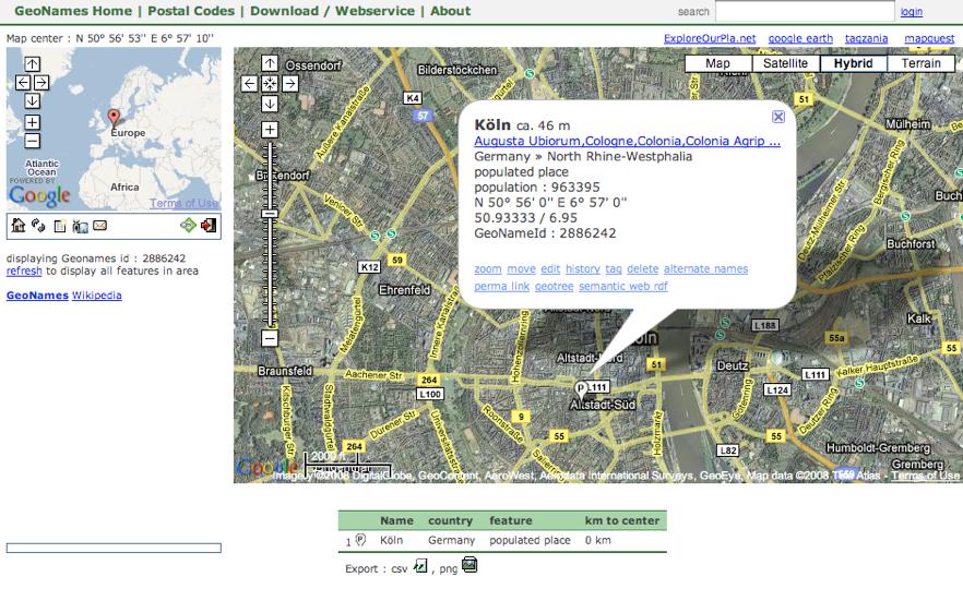
5 From Maps to Info URL links from points on a map The primary use of spatio temporal information on the web remains linking from dynamic maps to associated data through URL links Using the map as a visual index to text, images or other maps Using the map as a map w/ annotation E.g., traffic maps

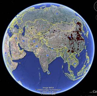
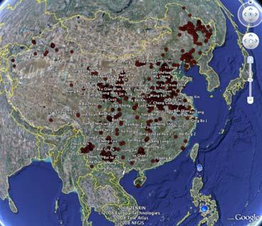
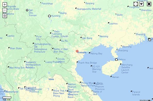
6 Mosques in China

7 From Text or Image to Map On the fly creation of maps from query results Links within documents to explanatory maps A spatial visual annotation of the text or image
8

9 Time Maps Combining spatial and temporal aspects in a single display Interactive map interfaces - enables interrogation of a time and space context Displaying change over time on a map e.g., video or flash display Showing attributes e.g., charts, color changes, etc. in a spatio-temporal context

10 Animation: Video / Flash Display Animation displays a visual narrative of time and place Mission Video on You Tube

11 California Mission Indian Population
12 Integrating Spatial Information Integrating maps and/or map layers Visualization of comparisons Navigation as dynamic filtering Spatial analysis Linking between maps and other types of spatial and temporal data Text descriptions and historical maps Diverse cultural expressions of time and space Images, stories, songs, diagrams, etc.
13 Methods of Implementation GIS and geospatial databases w/ web display application Google Earth/Maps - kml / xml data Contextualizing, annotating of text / xml data Using web resources and services Mashups, linking to services, using API s etc The choice has an impact on visualization
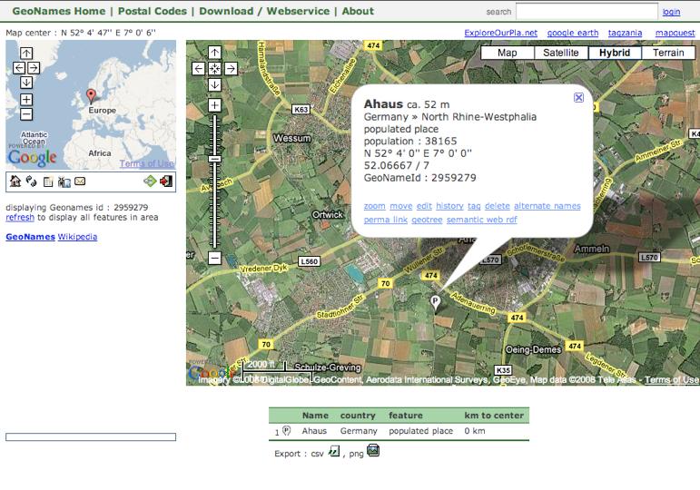
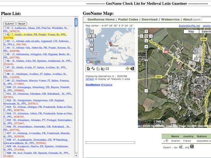
14 Case Study: Medieval Latin Places A quick prototype testing integration and visualization options Begin with place name lists Latin Place Names with reference to modern place names in early 20th century Link modern place names to contemporary gazetteer Identify latitude and longitude and reference number from contemporary gazetteer

15 Orbis Latinus - Letter A
16
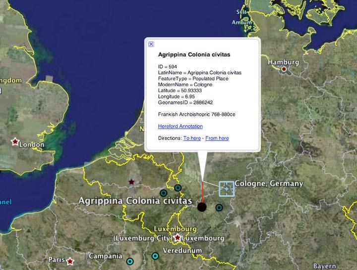
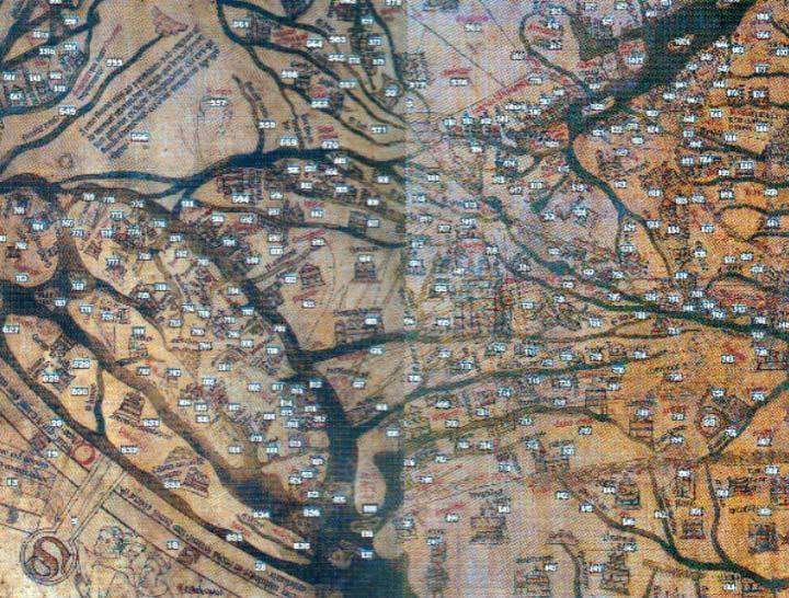
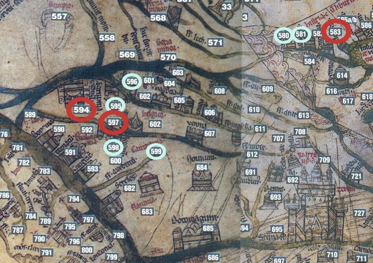
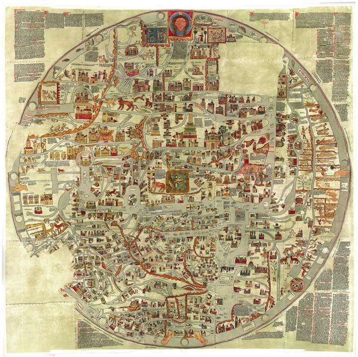
17 Dynamic Map Integration Implement web display of linkage to modern places with web map Implement Google Earth Map with capability of linking to web resources
18
19
20 Spatial and Temporal Links Identify temporal information sources Identify historical maps Link to historical atlas data Link to Medieval maps with annotations
21 O
22
23

24 Hereford Mapa Mundi 1300ce
25
26
27
28 Explorations Enable multiple routes of navigation Modern map/satellite image - to text and historical map images Text to modern map and historical map image Medieval map to current information Next experiments Implement time annotation Link to references in published works Link from Medieval map to contextual information
29 Results Development is technically possible and not difficult Availability of adequate resources is an issue copyright for published maps and texts Primary questions of interest are digital scholarship issues How will the visualizations be read by users now How can the nuances of precision, accuracy and completion be represented Can the new systems be used to simulate old paradigms What is the new paradigm of spatio-temporal understanding that is developing
30 Spatio-temporal temporal Thinking Primary questions of interest are digital scholarship issues How will the visualizations be read by users now How can the nuances of precision, accuracy and completion be represented Can the new systems be used to simulate old paradigms What is the new paradigm of spatio-temporal understanding that is developing
31 Scholars and Learners Multiple products - different interfaces A scholars reference tool Historical Gazetteer Enabling linking of contextual information w/o having to recreate the gazetteer Enabling community input and editing A learners tool navigation, browsing, exploring linking contextual information providing narratives helping visualize the world as it was understood
32
GIS Visualization: A Library s Pursuit Towards Creative and Innovative Research
 GIS Visualization: A Library s Pursuit Towards Creative and Innovative Research Justin B. Sorensen J. Willard Marriott Library University of Utah justin.sorensen@utah.edu Abstract As emerging technologies
FAO GAEZ Data Portal
 FAO GAEZ Data Portal www.fao.org/nr/gaez Renato Cumani Environment Officer Land and Water Division Natural Resources Management and Environment Department Food and Agriculture Organization of the UN October
 estrandh@uoregon.edu Introduction The general topic of this paper describes a unique cartographic project depicting a mountain landscape for the Friends of Opal Creek (F.O.C.), a non-profit organization.
You are Building Your Organization s Geographic Knowledge
 You are Building Your Organization s Geographic Knowledge And Increasingly Making it Available Sharing Data Publishing Maps and Geo-Apps Developing Collaborative Approaches Citizens Knowledge Workers Analysts
Contextualizing Historical Places in a Gazetteer by Using Historical Maps and Linked Data
 Contextualizing Historical Places in a Gazetteer by Using Historical Maps and Linked Data Esko Ikkala, Jouni Tuominen, and Eero Hyvönen Semantic Computing Research Group (SeCo), Aalto University http://www.seco.tkk.fi/,
When Map Quality Matters
 When Map Quality Matters 50% 25% Powerful geospatial mapping tools for Adobe Creative Cloud and offline map solutions for mobile devices 20% When Map Quality Matters 10% We re focused on creating powerful
Features and Benefits
 Autodesk LandXplorer Features and Benefits Use the Autodesk LandXplorer software family to help improve decision making, lower costs, view and share changes, and avoid the expense of creating physical
Time Series Analysis with SAR & Optical Satellite Data
 Time Series Analysis with SAR & Optical Satellite Data Thomas Bahr ESRI European User Conference Thursday October 2015 harris.com Motivation Changes in land surface characteristics mirror a multitude of
Dynamic Ontology Service for Historical Persons and Places Based on Crowdsourcing
 Dynamic Ontology Service for Historical Persons and Places Based on Crowdsourcing 22.1.2016, COST RRL WG2 Workshop Jouni Tuominen Semantic Computing Research Group (SeCo), http://seco.cs.aalto.fi, Aalto
Bentley Map Advancing GIS for the World s Infrastructure
 Bentley Map Advancing GIS for the World s Infrastructure Presentation Overview Why would you need Bentley Map? What is Bentley Map? Where is Bentley Map Used? Red text signifies new things in Bentley Map
Navigating to Success: Finding Your Way Through the Challenges of Map Digitization
 Library Faculty Presentations Library Faculty/Staff Scholarship & Research 10-15-2011 Navigating to Success: Finding Your Way Through the Challenges of Map Digitization Cory K. Lampert University of Nevada,
Leveraging the GIS Capability within FlexiCadastre
 Managing Local Land Concerns, Maintaining Corporate Governance Leveraging the GIS Capability within FlexiCadastre Regional User Conference, North America May 6 th May 9 th, 2013 Cameron McKellar, Technical
Principles of IR. Hacettepe University Department of Information Management DOK 324: Principles of IR
 Principles of IR Hacettepe University Department of Information Management DOK 324: Principles of IR Some Slides taken from: Ray Larson Geographic IR Overview What is Geographic Information Retrieval?
Geospatial Products V8i (SELECTseries 1)
") Geospatial Products V8i (SELECTseries 1) Keith Raymond Product Manager Geospatial Desktop Products Presentation Overview What are the various products? Why would you need them? Demonstrations 2 WWW.BENTLEY.COM
Geospatial Products V8i (SELECTseries 1) Keith Raymond Product Manager Geospatial Desktop Products Presentation Overview What are the various products? Why would you need them? Demonstrations 2 WWW.BENTLEY.COM
AUTOMATISIERTE ZEITREIHENANALYSE VON FERNERKUNDUNGSDATEN FÜR DAS MONITORING VON OBERFLÄCHENGEWÄSSERN
 Place image here (10 x 3.5 ) AUTOMATISIERTE ZEITREIHENANALYSE VON FERNERKUNDUNGSDATEN FÜR DAS MONITORING VON OBERFLÄCHENGEWÄSSERN THOMAS BAHR & NICOLAI HOLZER 23. Workshop Arbeitskreis Umweltinformationssysteme
A Geographer s role in a Google Maps World. Jeremy Bartley ESRI
 A Geographer s role in a Google Maps World Jeremy Bartley ESRI 1 It is a good time to be a Geographer. 2 Microsoft, Google, Yahoo, and others are pushing geographic awareness to the general public Providing
Re-imagining Religion: The Spatial Humanities as a Framework for New Scholarship
 2010 Re-imagining Religion: The Spatial Humanities as a Framework for New Scholarship David J. Bodenhamer The Polis Center at IUPUI Virtual Center for Spatial Humanities New Technologies and Interdisciplinary
an accessible interface to marine environmental data Russell Moffitt
 an accessible interface to marine environmental data Russell Moffitt The Atlas Project GOAL: To provide a single point of access to oceanographic and environmental data for use by marine resource researchers,
Geometric Algorithms in GIS
 Geometric Algorithms in GIS GIS Visualization Software Dr. M. Gavrilova GIS Software for Visualization ArcView GEO/SQL Digital Atmosphere AutoDesk Visual_Data GeoMedia GeoExpress CAVE? Visualization in
Combining Geospatial and Statistical Data for Analysis & Dissemination
 Combining Geospatial and Statistical Data for Analysis & Dissemination (with Special Reference to Qatar Census 2010) Presentation by Mansoor Al Malki, Director of IT Department Qatar Statistics Authority
Introduction to Google Mapping Tools
 Introduction to Google Mapping Tools Google s Mapping Tools Explore geographic data. Organize your own geographic data. Visualize complex data. Share your data with the world. Tell your story and educate
From Research Objects to Research Networks: Combining Spatial and Semantic Search
 From Research Objects to Research Networks: Combining Spatial and Semantic Search Sara Lafia 1 and Lisa Staehli 2 1 Department of Geography, UCSB, Santa Barbara, CA, USA 2 Institute of Cartography and
Iowa Department of Transportation Office of Transportation Data GIS / CAD Integration
 Iowa Department of Transportation Office of Transportation Data GIS / CAD Integration From GIS data to CAD graphics - Iowa DOT's workflow utilizing GeoMedia and MicroStation to develop map products. Mark
ArcGIS. for Server. Understanding our World
 ArcGIS for Server Understanding our World ArcGIS for Server Create, Distribute, and Manage GIS Services You can use ArcGIS for Server to create services from your mapping and geographic information system
Arboretum Explorer: Using GIS to map the Arnold Arboretum
 Arboretum Explorer: Using GIS to map the Arnold Arboretum Donna Tremonte, Arnold Arboretum of Harvard University 2015 Esri User Conference (UC), July 22, 2015 http://arboretum.harvard.edu/explorer Mission
FUNDAMENTALS OF GEOINFORMATICS PART-II (CLASS: FYBSc SEM- II)
") FUNDAMENTALS OF GEOINFORMATICS PART-II (CLASS: FYBSc SEM- II) UNIT:-I: INTRODUCTION TO GIS 1.1.Definition, Potential of GIS, Concept of Space and Time 1.2.Components of GIS, Evolution/Origin and Objectives
FUNDAMENTALS OF GEOINFORMATICS PART-II (CLASS: FYBSc SEM- II) UNIT:-I: INTRODUCTION TO GIS 1.1.Definition, Potential of GIS, Concept of Space and Time 1.2.Components of GIS, Evolution/Origin and Objectives
G. I. Science Education: A Computing Perspective
 A Position Statement on G. I. Science Education: A Computing Perspective (A Panel Discussion in UCGIS Summer Assembly 2008) By Shashi Shekhar McKnight Distinguished University Professor Faculty of Computer
Smart Data Collection and Real-time Digital Cartography
 Smart Data Collection and Real-time Digital Cartography Yuji Murayama and Ko Ko Lwin Division of Spatial Information Science Faculty of Life and Environmental Sciences University of Tsukuba IGU 2013 1
Crime Analyst Extension. Christine Charles
 Crime Analyst Extension Christine Charles ccharles@esricanada.com Agenda Why use Crime Analyst? Overview Tools Demo Interoperability With our old software it could take a police officer up to forty minutes
Lecture 9: Reference Maps & Aerial Photography
 Lecture 9: Reference Maps & Aerial Photography I. Overview of Reference and Topographic Maps There are two basic types of maps? Reference Maps - General purpose maps & Thematic Maps - maps made for a specific
ArcGIS is Advancing. Both Contributing and Integrating many new Innovations. IoT. Smart Mapping. Smart Devices Advanced Analytics
 ArcGIS is Advancing IoT Smart Devices Advanced Analytics Smart Mapping Real-Time Faster Computing Web Services Crowdsourcing Sensor Networks Both Contributing and Integrating many new Innovations ArcGIS
Web georeference of historical maps
 Vassilios Tsioukas Web georeference of historical maps Keywords: Historical maps, Georeference, Cartography, Cartographic Heritage Summary The creation of an application to perform the geo-referencing
Safe to Save? Archive Options for Geodatabases. Jeff Essic North Carolina State University Libraries
 Safe to Save? Archive Options for Geodatabases Jeff Essic North Carolina State University Libraries 2011 ESRI International Users Conference July 13, 2011 GeoMAPP Geospatial Multistate Archive and Preservation
Demystifying ArcGIS Online. Karen Lizcano Esri
 Demystifying ArcGIS Online Karen Lizcano Esri An Integrated Web GIS Platform Desktop Web Device Powered by Services Managed via Portal Access from any Device Portal Server Online Content and Services ArcGIS
file://q:\report1\greenatlasfinalreportindex.html
 Page 1 of 8 Quick Links WATER MANAGEMENT INTERNSHIP USDA HIS GRANT FUNDED FINAL PROJECT REPORT SUBMITTED BY MELISSA QUINTANA 11/07/07-03/24/08 Summary Provided is an assessment of my accomplishments for
Effective Visualization Tool for Job Searching
 Effective Visualization Tool for Job Searching Yilin Gu Andries H. Smith,1 Jong Kwan Lee Xinyue Ye Soo K. Kim Dept. of Comp. Science School of Earth, Env. & Society Dept. of Comp. Info. Science Bowling
GIS CONCEPTS Part I. GIS ON THE WEB Part II
 Week 2 GIS CONCEPTS Part I GIS ON THE WEB Part II topics of the week part I GIS functions and GIS data Spatial relationships Organizing convention for spatial data Store Information by thematic layers
5A.10 A GEOSPATIAL DATABASE AND CLIMATOLOGY OF SEVERE WEATHER DATA
 5A.10 A GEOSPATIAL DATABASE AND CLIMATOLOGY OF SEVERE WEATHER DATA Steve Ansari * and Stephen Del Greco NOAA National Climatic Data Center, Asheville, North Carolina Mark Phillips University of North Carolina
These modules are covered with a brief information and practical in ArcGIS Software and open source software also like QGIS, ILWIS.
 Online GIS Training and training modules covered are: 1. ArcGIS, Analysis, Fundamentals and Implementation 2. ArcGIS Web Data Sharing 3. ArcGIS for Desktop 4. ArcGIS for Server These modules are covered
A Model of GIS Interoperability Based on JavaRMI
 A Model of GIS Interoperability Based on Java Gao Gang-yi 1 Chen Hai-bo 2 1 Zhejiang University of Finance & Economics, Hangzhou 310018, China 2 College of Computer Science and Technology, Zhejiang UniversityHangzhou
Some of the underlying goals of the GIS Library are to:
 1 2001 It was born out of the recognition that several of the regions prominent resource management agencies have similar, if not shared, requirements for GIS data. Some of the underlying goals of the
Gistat: moving towards a location information management system
 Gistat: moving towards a location information management system (merging geographical, statistical and historical information) Pina Grazia Ticca Marco Ballin Istat - Italy Aguascalientes, Mexico 2-4 December
Aileen Buckley, Ph.D. and Charlie Frye
 An Information Model for Maps: Towards Production from GIS Databases Aileen Buckley, Ph.D. and Charlie Frye Researchers, ESRI GIS vs. cart GIS Outline of the presentation Introduction Differences between
Production Line Tool Sets
 Production Line Tool Sets Tools for high-quality database production and cartographic output Production Line Tool Sets Production Line Tool Sets (PLTS) by ESRI are a collection of software applications
INTRODUCTION. In March 1998, the tender for project CT.98.EP.04 was awarded to the Department of Medicines Management, Keele University, UK.
 INTRODUCTION In many areas of Europe patterns of drug use are changing. The mechanisms of diffusion are diverse: introduction of new practices by new users, tourism and migration, cross-border contact,
Atlas Historical World Atlas By Rand Mcnally
 Atlas Historical World Atlas By Rand Mcnally If searched for a book by Rand Mcnally Atlas Historical World Atlas in pdf format, then you've come to faithful site. We present the complete option of this
Cartographic and Geospatial Futures
 Cartographic and Geospatial Futures 1. Web Cartography, WebGIS, & Virtual Globes--New Roles for Maps, GIS, and GIS professionals 2. Map Mashups, the Neo Neo-geography Movement, & Crowd-sourcing Geospatial
Visualizing Uncertainty: How to Use the Fuzzy Data of 550 Medieval Texts?
 Visualizing Uncertainty: How to Use the Fuzzy Data of 550 Medieval Texts? Stefan Jänicke, Institut für Informatik, Universität Leipzig David Joseph Wrisley, Department of English, American University of
What are the five components of a GIS? A typically GIS consists of five elements: - Hardware, Software, Data, People and Procedures (Work Flows)
") LECTURE 1 - INTRODUCTION TO GIS Section I - GIS versus GPS What is a geographic information system (GIS)? GIS can be defined as a computerized application that combines an interactive map with a database
LECTURE 1 - INTRODUCTION TO GIS Section I - GIS versus GPS What is a geographic information system (GIS)? GIS can be defined as a computerized application that combines an interactive map with a database
Animating Maps: Visual Analytics meets Geoweb 2.0
 Animating Maps: Visual Analytics meets Geoweb 2.0 Piyush Yadav 1, Shailesh Deshpande 1, Raja Sengupta 2 1 Tata Research Development and Design Centre, Pune (India) Email: {piyush.yadav1, shailesh.deshpande}@tcs.com
Developing 3D Geoportal for Wilayah Persekutuan Iskandar
 Developing 3D Geoportal for Wilayah Persekutuan Iskandar Dionnald Beh BoonHeng and Alias Abdul Rahman Department of Geoinformatics, Faculty of Geoinformation Engineering and Sciences, Universiti Teknologi
DP Project Development Pvt. Ltd.
 Dear Sir/Madam, Greetings!!! Thanks for contacting DP Project Development for your training requirement. DP Project Development is leading professional training provider in GIS technologies and GIS application
4D information management system for road maintenance using GIS
 icccbe 2010 Nottingham University Press Proceedings of the International Conference on Computing in Civil and Building Engineering W Tizani (Editor) 4D information management system for road maintenance
Write a report (6-7 pages, double space) on some examples of Internet Applications. You can choose only ONE of the following application areas:
 on some examples of Internet Applications. You can choose only ONE of the following application areas:") UPR 6905 Internet GIS Homework 1 Yong Hong Guo September 9, 2008 Write a report (6-7 pages, double space) on some examples of Internet Applications. You can choose only ONE of the following application
UPR 6905 Internet GIS Homework 1 Yong Hong Guo September 9, 2008 Write a report (6-7 pages, double space) on some examples of Internet Applications. You can choose only ONE of the following application
Development of a server to manage a customised local version of OpenStreetMap in Ireland
 Development of a server to manage a customised local version of OpenStreetMap in Ireland BłaŜej Ciepłuch 1, Jianghua Zheng 1, Peter Mooney 1,2, Adam C. Winstanley 1 1 Department of Computer Science, National
Lecture 2. A Review: Geographic Information Systems & ArcGIS Basics
 Lecture 2 A Review: Geographic Information Systems & ArcGIS Basics GIS Overview Types of Maps Symbolization & Classification Map Elements GIS Data Models Coordinate Systems and Projections Scale Geodatabases
The National Map Data Delivery Services
 The National Map Data Delivery Services U.S. Department of the Interior U.S. Geological Survey April 2015 Jim Langtry jlangtry@usgs.gov Topics for Today The National Map Delivery Services The National
Bentley Map Advancing GIS for the World s Infrastructure
 Bentley Map Advancing GIS for the World s Infrastructure Presentation Overview Why would you need Bentley Map? What is Bentley Map? Where is Bentley Map Used? Why would you need Bentley Map? Because your
A Correlation of. Eastern Hemisphere. Ohio s Learning Standards Social Studies: K-12 Grade 6
 A Correlation of Eastern Hemisphere To Grade 6 to,, Grade 6 Introduction This document demonstrates how, Eastern Hemisphere, Ohio Edition, meets : K-12 Social Studies for Grade 6. Correlation page references
STATE GEOGRAPHIC INFORMATION DATABASE
 STATE GEOGRAPHIC INFORMATION DATABASE Data Information and Knowledge Management STATE GEOGRAPHIC INFORMATION DATABASE EXECUTIVE SUMMARY Utah has developed one of the most comprehensive statewide GIS resources
Extraction of Spatio-Temporal data about Historical events from text documents
 Faculty of Environmental Sciences, Department of Geosciences, Chair of Geoinformatics Extraction of Spatio-Temporal data about Historical events from text documents Case Study: German-Herero war of resistance
Point data in mashups: moving away from pushpins in maps
 Point data in mashups: moving away from pushpins in maps Aidan Slingsby, Jason Dykes, Jo Wood gicentre, City University London Department of Information Science, City University London, Northampton Square,
Advanced Algorithms for Geographic Information Systems CPSC 695
 Advanced Algorithms for Geographic Information Systems CPSC 695 Think about Geography What is Geography The 3 W s of Geography What is where Why is it there Why do I care Data - Data - Data We all got
Web Visualization of Geo-Spatial Data using SVG and VRML/X3D
 Web Visualization of Geo-Spatial Data using SVG and VRML/X3D Jianghui Ying Falls Church, VA 22043, USA jying@vt.edu Denis Gračanin Blacksburg, VA 24061, USA gracanin@vt.edu Chang-Tien Lu Falls Church,
Map image from the Atlas of Oregon (2nd. Ed.), Copyright 2001 University of Oregon Press
, Copyright 2001 University of Oregon Press") Map Layout and Cartographic Design with ArcGIS Desktop Matthew Baker ESRI Educational Services Redlands, CA Education UC 2008 1 Seminar overview General map design principles Working with map elements
Map Layout and Cartographic Design with ArcGIS Desktop Matthew Baker ESRI Educational Services Redlands, CA Education UC 2008 1 Seminar overview General map design principles Working with map elements
Application of WebGIS and VGI for Community Based Resources Inventory. Jihn-Fa Jan Department of Land Economics National Chengchi University
 Application of WebGIS and VGI for Community Based Resources Inventory Jihn-Fa Jan Department of Land Economics National Chengchi University OUTLINE Introduction Methodology Results Conclusions 2 MOTIVATION
Water Atlas Overview. Myakka River Management Coordinating Council June 22, 2012 Englewood, Florida
 Water Atlas Overview Myakka River Management Coordinating Council June 22, 2012 Englewood, Florida What is the Water Atlas? A data warehouse A set of interactive maps A collection of tools for viewing/analyzing
Techniques for Science Teachers: Using GIS in Science Classrooms.
 Techniques for Science Teachers: Using GIS in Science Classrooms. After ESRI, 2008 GIS A Geographic Information System A collection of computer hardware, software, and geographic data used together for
DATA 301 Introduction to Data Analytics Geographic Information Systems
 DATA 301 Introduction to Data Analytics Geographic Information Systems Dr. Ramon Lawrence University of British Columbia Okanagan ramon.lawrence@ubc.ca DATA 301: Data Analytics (2) Why learn Geographic
A Review: Geographic Information Systems & ArcGIS Basics
 A Review: Geographic Information Systems & ArcGIS Basics Geographic Information Systems Geographic Information Science Why is GIS important and what drives it? Applications of GIS ESRI s ArcGIS: A Review
Course Syllabus. Geospatial Data & Spatial Digital Technologies: Assessing Land Use/Land Cover Change in the Ecuadorian Amazon.
 Course Syllabus Geospatial Data & Spatial Digital Technologies: Assessing Land Use/Land Cover Change in the Ecuadorian Amazon Co- Instructors Dr. Carlos F. Mena, Universidad San Francisco de Quito, Ecuador
Enabling the Image Analyst (IA) to use the geodatabase
 to use the geodatabase") Enabling the Image Analyst (IA) to use the geodatabase Rick Racine, BAE Systems, Reston, VA Stewart Walker, BAE Systems, San Diego, CA 2008 ESRI Federal User Conference, Washington, D.C., 21 February 2610020508
Enabling the Image Analyst (IA) to use the geodatabase Rick Racine, BAE Systems, Reston, VA Stewart Walker, BAE Systems, San Diego, CA 2008 ESRI Federal User Conference, Washington, D.C., 21 February 2610020508
USGIF Essential Body of Knowledge Competency Areas
 GEOINT Job/Practice Analysis USGIF, in consultation with psychometric consultants and the GEOINT community, executed a job/practice analysis to identify common competencies within the GEOINT profession.
ArcGIS for Desktop. ArcGIS for Desktop is the primary authoring tool for the ArcGIS platform.
 ArcGIS for Desktop ArcGIS for Desktop ArcGIS for Desktop is the primary authoring tool for the ArcGIS platform. Beyond showing your data as points on a map, ArcGIS for Desktop gives you the power to manage
HIGH RESOLUTION BASE MAP: A CASE STUDY OF JNTUH-HYDERABAD CAMPUS
 HIGH RESOLUTION BASE MAP: A CASE STUDY OF JNTUH-HYDERABAD CAMPUS K.Manjula Vani, Abhinay Reddy, J. Venkatesh, Ballu Harish and R.S. Dwivedi ABSTRACT The proposed work High Resolution Base map: A Case study
Lesser Sunda - Banda Seascape Atlas
 Lesser Sunda - Banda Seascape Atlas Report prepared for the development of online interactive map for Lesser Sunda Banda Seascape by WorldFish December 2014 http://sbsatlas.reefbase.org Page 1 of 8 Table
GIS Functions and Integration. Tyler Pauley Associate Consultant
 GIS Functions and Integration Tyler Pauley Associate Consultant Contents GIS in AgileAssets products Displaying data within AMS Symbolizing the map display Display on Bing Maps Demo- Displaying a map in
GIS Applications on Environmental Education in Taiwan
 GIS Applications on Environmental Education in Taiwan Track: Education Authors: Yu-Chen Lai, Mei-Ling Yeh, Tien-Yin Chou Abstract GIS is a perfect vehicle to deliver environmental knowledge and spatial
Beyond points: How to turn SMW into a complete Geographic Information System
 Beyond points: How to turn SMW into a complete Geographic Information System SMWCon 2013, New-York Pierre Racine Contributor to PostGIS Research Professional Center for Forest Research Québec, Canada Objectives
Working with Temporal Data in ArcGIS
 Working with Temporal Data in ArcGIS By Aileen Buckley, Esri Research Cartographer Time is an important dimension in many types of geospatial visualizations and analyses. The temporal aspect adds when
Department of Computer Science Federal University of São Carlos São Carlos SP, Brazil
 Department of Computer Science Federal University of São Carlos São Carlos SP, Brazil 12th International Conference on Enterprise 50 Information Systems ICEIS 2010 / Outline Motivations and Goals Multidimensional
David Rumsey Map Collection
 David Rumsey Map Collection Cartography Associates LIS 647 System Analysis for Information Management Spring 2008 Dr. Luz Quiroga lquiroga@hawaii.edu William Yip Information and Computer Science wyip@hawaii.edu
Discovery and Access of Geospatial Resources using the Geoportal Extension. Marten Hogeweg Geoportal Extension Product Manager
 Discovery and Access of Geospatial Resources using the Geoportal Extension Marten Hogeweg Geoportal Extension Product Manager DISCOVERY AND ACCESS USING THE GEOPORTAL EXTENSION Geospatial Data Is Very
Massachusetts Institute of Technology Department of Urban Studies and Planning
 Massachusetts Institute of Technology Department of Urban Studies and Planning 11.520: A Workshop on Geographic Information Systems 11.188: Urban Planning and Social Science Laboratory GIS Principles &
ArcGIS Enterprise: Administration Workflows STUDENT EDITION
 ArcGIS Enterprise: Administration Workflows STUDENT EDITION Copyright 2019 Esri All rights reserved. Course version 1.1. Version release date April 2019. Printed in the United States of America. The information
Geography for the 2020 Round of Census
 Boundaries Key Census Data EA Id Population Male Female EA Id Area EA Id Num HH Avg HH size Geography for the 2020 Round of Census Linda Peters, Esri lpeters@esri.com Integration of Statistical and Geospatial
Pleiades: Beyond the Barrington Atlas. Richard Talbert, principal investigator Sean Gillies, chief engineer
 Pleiades: Beyond the Barrington Atlas Richard Talbert, principal investigator Sean Gillies, chief engineer Pleiades Project, Ancient World Mapping Center University of North Carolina at Chapel Hill, U.S.A.
Lecture 11. Data Standards and Quality & New Developments in GIS
 Lecture 11 Data Standards and Quality & New Developments in GIS Lecture 11: Outline I. Data Standards and Quality 1. Types of Spatial Data Standards 2. Data Accuracy II. New Developments/The Future of
CAD: Introduction to using CAD Data in ArcGIS. Kyle Williams & Jeff Reinhart
 CAD: Introduction to using CAD Data in ArcGIS Kyle Williams & Jeff Reinhart What we will accomplish today Overview of ArcGIS CAD Support Georeferencing CAD data for ArcGIS How Mapping Specification for
Visual Thinking with Spatial Data: Using Spatial Organization to Access Library Information
 Visual Thinking with Spatial Data: Using Spatial Organization to Access Library Information MHS: Who we are Established 1846 Broad Collections Focus Library and Exhibits Statewide Network of Historic Sites
Welcome! Power BI User Group (PUG) Copenhagen
 Copenhagen") Welcome! Power BI User Group (PUG) Copenhagen Making Maps in Power BI Andrea Martorana Tusa BI Specialist Welcome to Making maps in Power BI Who am I? First name: Andrea. Last name: Martorana Tusa. Italian,
Welcome! Power BI User Group (PUG) Copenhagen Making Maps in Power BI Andrea Martorana Tusa BI Specialist Welcome to Making maps in Power BI Who am I? First name: Andrea. Last name: Martorana Tusa. Italian,
OGC GEOPACKAGE AND HOW OPEN SOURCE IS CHANGING THE WAY GOVERNMENTS THINK ABOUT STANDARDS. Nathan Frantz Geospatial Research Lab
 OGC GEOPACKAGE AND HOW OPEN SOURCE IS CHANGING THE WAY GOVERNMENTS THINK ABOUT STANDARDS Nathan Frantz Geospatial Research Lab Dr. Ben Tuttle National Geospatial-Intelligence Agency FOSS4G 2015 Geospatial
COURSE INTRODUCTION & COURSE OVERVIEW
 week 1 COURSE INTRODUCTION & COURSE OVERVIEW topics of the week Instructor introduction Students introductions Course logistics Course objectives Definition of GIS The story of GIS introductions Who am
GIS-T 2010 Building a Successful Geospatial Data Sharing Framework: A Ohio DOT Success Story
 GIS-T 2010 Building a Successful Geospatial Data Sharing Framework: A Ohio DOT Success Story ODOT District 2 GIS John Puente District 1 GIS Coordinator\ Planning Administrator 2 Interoperability 3 District
YYT-C3002 Application Programming in Engineering GIS I. Anas Altartouri Otaniemi
 YYT-C3002 Application Programming in Engineering GIS I Otaniemi Overview: GIS lectures & exercise We will deal with GIS application development in two lectures. Because of the versatility of GIS data models
Geographic Information Systems (GIS) - Hardware and software in GIS
 - Hardware and software in GIS") PDHonline Course L153G (5 PDH) Geographic Information Systems (GIS) - Hardware and software in GIS Instructor: Steve Ramroop, Ph.D. 2012 PDH Online PDH Center 5272 Meadow Estates Drive Fairfax, VA 22030-6658
PDHonline Course L153G (5 PDH) Geographic Information Systems (GIS) - Hardware and software in GIS Instructor: Steve Ramroop, Ph.D. 2012 PDH Online PDH Center 5272 Meadow Estates Drive Fairfax, VA 22030-6658
Task 1: Start ArcMap and add the county boundary data from your downloaded dataset to the data frame.
 Exercise 6 Coordinate Systems and Map Projections The following steps describe the general process that you will follow to complete the exercise. Specific steps will be provided later in the step-by-step
Using CAD data in ArcGIS
 Using CAD data in ArcGIS Phil Sanchez and Jeff Reinhart Esri UC 2014 Technical Workshop Agenda Overview of ArcGIS CAD Support Using CAD Datasets in ArcMap Georeferencing CAD data for ArcGIS Loading CAD
How to Construct Urban Three Dimensional GIS Model based on ArcView 3D Analysis
 How to Construct Urban Three Dimensional GIS Model based on ArcView 3D Analysis Ko Ko Lwin Division of Spatial Information Science Graduate School of Life and Environmental Sciences University of Tsukuba
Esri UC2013. Technical Workshop.
 Esri International User Conference San Diego, California Technical Workshops July 9, 2013 CAD: Introduction to using CAD Data in ArcGIS Jeff Reinhart & Phil Sanchez Agenda Overview of ArcGIS CAD Support