How to Effectively Use Weather Radar. Presented by: Robert Reale Company:
|
|
|
- Cleopatra Hunt
- 6 years ago
- Views:
Transcription

1 How to Effectively Use Weather Radar Presented by: Robert Reale Company:
2 Who Am I? What is WeatherWorks? WeatherWorks Private weather consulting firm located in Hackettstown, NJ Over 30 years in the snow and ice industry We are the best at interpreting and communicating weather data Robert Reale Rutgers University graduate Director of Education, Assistant Operations Manager Main research areas include: - Improve forecasting of snow & ice - Radar Meteorology

3 Session Overview What is RADAR? How Does it Work? Regional vs Doppler Radar Doppler Radar Intricacies Classic Radar Signatures of Various Weather Events Snow and Ice Manager: How to Better Radar

4 What is RADAR? RADAR is an acronym for RAdio Detection And Ranging. RADAR works by sending electromagnetic waves and listening for the return signals. Radar is calibrated to help detect mainly atmospheric moisture (rain, snow, sleet, hail).


5 How Does RADAR Work?


")


6 How Do You Radar? NOAA (National Weather Service) Local news or television station Weather Channel Internet: (WUnderground, Intellicast, etc) Phone Apps Social media outlets Private weather service

7 How Do You Radar? 4AM - 9AM National Composite Regional Composite Local Doppler Airport Tower Radar (TDWR)
8 How Do You Radar? 730AM - 9AM National Composite Regional Composite Local Doppler Airport Tower Radar (TDWR)
9 How Do You Radar? 8AM - 9AM National Composite Regional Composite Local Doppler Airport Tower Radar (TDWR)

10 How Do You Radar? 8AM - 9AM National Composite Regional Composite Local Doppler Airport Tower Radar
11 Composite Radars Can be regional or national views. Created using an algorithm to combine all of the local Doppler radars together. Useful to get the big picture of what is happening. However, composite radars can be a bit deceiving, and often over-estimate the coverage of precipitation. Many news stations and apps show composite radars

12 Composite Radars Notice how widespread the showers look on the regional compared to the local!
13 Doppler Radars Uses the Doppler Effect to measure the distance of a meteorological target, and its approaching or receding velocity towards the Doppler Radar site. Radar locations: Over 140 in the US Over 30 in Canada Doppler radars may struggle to detect: Precipitation far away from the radar location Precipitation obstructed by mountains Very light precipitation, such as flurries or drizzle

14 NWS Local Doppler Radars

15 Airport Tower Radars (TDWRs)

16 Canadian Radars
17 How far can Doppler Radars reach? Local Doppler radars most effectively detect precipitation within 50 miles, but can reach over 100 miles away. The radars are orientated slightly upward, which means the beams gradually increase in elevation the farther they travel from the radar. Radar Site

18 So the Radar Tilted Upward Means? Radar is NOT detecting what is occurring at the ground, but rather at an angle above it. The base angle is 0.5 Close to the radar is representative of nearly the ground, but further away is NOT. WeatherWorks Trenton Radar Site 1500 ft Trenton 5000 ft WeatherWorks Radar 20mi 65mi

19 Why is That Not Falling? Virga Virga is observable precipitation falling from a cloud, but evaporates before reaching the ground. Virga can happen at any time of the year, but it is most common during the winter when the air is drier. My radar shows snow, but nothing is falling. What do I do with my crews?

20 Why is That Not Falling? Virga Loop time: 725AM 855AM Most of this is NOT reaching the ground

21 Classic Winter Virga Example: Feb 16, 2015: 9-10PM

22 Classic Winter Virga Example Feb 16, 2015: 10PM
23 Classic Winter Virga Example Feb 16, 2015: 10-11PM
24 Classic Winter Virga Example Feb 16, 2015: 11PM

25 Classic Winter Virga Example Feb 16, 2015: 11PM - 12AM

26 Classic Winter Virga Example - TDWR Feb 16, 2015: 11PM - 12AM
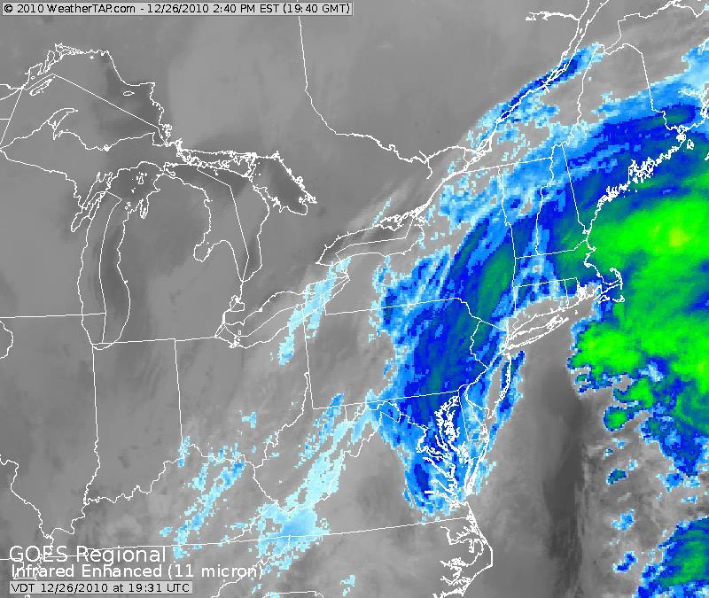
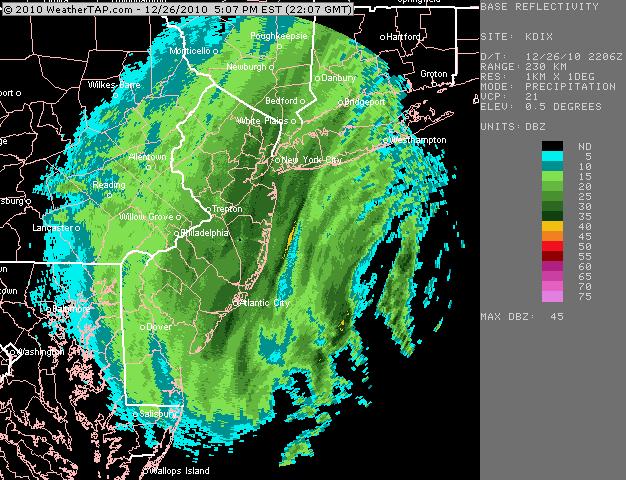
27 Further Understanding Doppler Radar 1. Clear Air Mode Mode when little or no precipitation is detected Scale ranges from -28 dbz to 28 dbz Very sensitive > can detect, birds, smoke, dust Useful for detecting very light precipitation (flurries, drizzle, etc) Updated every 10 minutes 2. Precipitation Mode Mode used when actual precipitation is detected in area Scale ranges from 5 dbz to 75 dbz or greater Most common mode seen by public on television / internet Useful in determining intensity of precipitation Updated every 5 minutes, or less


28 Radar Deceptions Why does the radar look like this? Any guess as to what this is? Hint: It s not a shower

29 Let s Talk P-Type

30 Rain or Snow? Where is the Mixing Line? As mentioned, regional composite radars are useful, but can be misleading and appear overdone. Winter precipitation type radars are also nice and pleasing to look at, but they are just radar algorithms. That means it s not necessarily what is happening, and again can often be wrong.

31 A Better Way to Rain vs Snow: Dual-Pol A few years ago, NOAA developed new radar technology, allowing the radar to send beams in two directions (horizontal and vertical). This enables the RADAR to detect both size AND shape of precipitation. This is incredibly useful, especially for determining precipitation type during the winter. Correlation Coefficient: This shows how similar precipitation particles are to each other. The lower the number, the more different the particles are from each other. Low CC is usually indicative of hail or wintry mix. In this case, the strip of yellowish colors indicate the change over line from snow to rain.


32 Blizzard of 17 : From a Radar Perspective March Blizzard of 2017 was a very challenging storm throughout the Northeast, with snow to significant sleet. This snuck up on some, however as the storm was progressing, radar clearly showed the mixing line moving north. Dual-pol was essential in determining this.
33 Identifying Weather Events on Radar Major Winter Storms Banding Snow Showers Additional Water-Enhanced Snow Severe Thunderstorms Detecting Boundaries Hurricanes

34 Classic Major Midwest Snow Storm February 1-2, 2011: Ground Hog s Day Blizzard
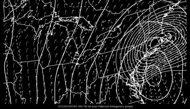
35 Classic Major Nor Easter December 26, 2010: Boxing Day Blizzard

36 Classic Lake Effect Snow Showers March 18, 2015 (8-9AM)

37 Classic Lake Effect Snow Showers March 18, 2015 (8-9AM)


38 Classic Lake Effect Snow Showers March 18, 2015 (8-9AM)

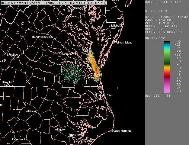
39 Other Water-Enhanced Snow Showers January 5, 2016

40 Detecting Severe Weather May 22, 2014

41 Detecting Boundaries September 5, 2012

42 Hurricane - Isaac August 29, 2012
43 How Does WeatherWorks Use Radar? Obviously there is a lot more that goes into interpreting and understanding radar than just looking at it. We constantly combine our radar knowledge with actual ground truth to verify precipitation type, intensity, and impacts to various surfaces. This is done through additional resources, including: Airport observations Mesonets Trained Spotters Webcams Additional TDWR radars


44
45 How Can YOU Better Radar? Use composite (regional) radars for the big picture, but use Doppler (local) radars for better detail and accuracy. Learn where the nearest Doppler Radar site is located, as well as surrounding ones Understand the radar is detecting reflectivity ABOVE the ground, and how high varies based on distance from the radar site. - Be aware of virga - Radar may over-shoot low level snow showers For more accurate rain / snow lines, use dual-pol and be aware of radar algorithms

 http://aviationweather.")

46 How Can YOU Better Radar? Combine radar with actual ground truth. Sources of ground truth include: - Airport observations (METARs) - Webcams - Weather Forums / Social Media - Looking outside


47 Recommended Radar Sources Desktop: - NOAA - WeatherTap Phone App: - RadarScope - WeatherTap Mobile - GR2Analyst
48
49 Questions? Contact Information: Robert Reale
Weather can change quickly...are you on top of the changes?
 Weather Access Bob Glancy NOAA National Weather Service, Boulder, CO Near Cedar Point, CO May 9, 2004 Weather can change quickly...are you on top of the changes? National Weather Service Local offices:
Weather Compass Webquest: Lab/Activity Edition
 Weather Compass Webquest: Lab/Activity Edition www.weathercompass.webs.com 1 Name: Date: Welcome to the Weather Compass Webquest: Activity/Lab Edition. This webquest was created by the National Oceanic
Meteorology 311. RADAR Fall 2016
 Meteorology 311 RADAR Fall 2016 What is it? RADAR RAdio Detection And Ranging Transmits electromagnetic pulses toward target. Tranmission rate is around 100 s pulses per second (318-1304 Hz). Short silent
The Montague Doppler Radar, An Overview
 ISSUE PAPER SERIES The Montague Doppler Radar, An Overview June 2018 NEW YORK STATE TUG HILL COMMISSION DULLES STATE OFFICE BUILDING 317 WASHINGTON STREET WATERTOWN, NY 13601 (315) 785-2380 WWW.TUGHILL.ORG
Charles Kuster Leadville, CO. Personal Overview
 Charles Kuster Leadville, CO Personal Overview Personal Overview Charles Kuster Leadville, CO OU to study meteorology Charles Kuster Leadville, CO Personal Overview OU to study meteorology Graduated in
INSURANCE CLAIMS PAST WEATHER INVESTIGATION
 INSURANCE CLAIMS PAST WEATHER INVESTIGATION Prepared For: John Smith ABC Insurance Company RE: Claim No.: 123456 Bryn Mawr, PA Prepared By: Your Weather Experts (800) 427-3456 PO Box 7100 Hackettstown,
IWT Scenario 2 Integrated Warning Team Workshop National Weather Service Albany, NY October 31, 2014
 IWT Scenario 2 Integrated Warning Team Workshop National Weather Service Albany, NY October 31, 2014 09 10 11 12 13 Scenario 2 Timeline December 9-13 Tue Wed Thu Fri Sat Tue, Dec. 9 @ 5 am 2014 2014 2014
Lab 6 Radar Imagery Interpretation
 Lab 6 Radar Imagery Interpretation Background Weather radar (radio detection and ranging) is another very useful remote sensing tool used in meteorological forecasting. Microwave radar was developed in
Moisture, Clouds, and Precipitation: Clouds and Precipitation. Dr. Michael J Passow
 Moisture, Clouds, and Precipitation: Clouds and Precipitation Dr. Michael J Passow What Processes Lift Air? Clouds require three things: water vapor, a condensation nucleus, and cooling Cooling usually
SCI-4 Mil-Brock-Weather Exam not valid for Paper Pencil Test Sessions
 SCI-4 Mil-Brock-Weather Exam not valid for Paper Pencil Test Sessions [Exam ID:1TLR5H 1 Warm air rises and cools. Moisture in the air forms clouds that will bring rain. What pressure system is described?
Event Date(s): 12:01 AM December 8th, 2013 through 2:00 PM December 12th, 2013
: 12:01 AM December 8th, 2013 through 2:00 PM December 12th, 2013") CLAIM Location: 123 Sample Road, Duluth, MN Event Date(s): 12:01 AM December 8th, 2013 through 2:00 PM December 12th, 2013 Prepared for: Sample Enterprises, Inc. Scope: Review best available records of
CLAIM Location: 123 Sample Road, Duluth, MN Event Date(s): 12:01 AM December 8th, 2013 through 2:00 PM December 12th, 2013 Prepared for: Sample Enterprises, Inc. Scope: Review best available records of
1 What Is Climate? TAKE A LOOK 2. Explain Why do areas near the equator tend to have high temperatures?
 CHAPTER 17 1 What Is Climate? SECTION Climate BEFORE YOU READ After you read this section, you should be able to answer these questions: What is climate? What factors affect climate? How do climates differ
Guided Notes Weather. Part 2: Meteorology Air Masses Fronts Weather Maps Storms Storm Preparation
 Guided Notes Weather Part 2: Meteorology Air Masses Fronts Weather Maps Storms Storm Preparation The map below shows North America and its surrounding bodies of water. Country borders are shown. On the
6 6 INFORMATION 165 docstructure.indb /08/11 14:43:39
 6 6 INFORMATION165 USEFUL INFORMATION SiriusXM RADIO DATA SERVICE* *: SiriusXM U.S. satellite and data services are available only in the 48 contiguous USA and DC. SiriusXM satellite service is also available
Natural Disasters PASSAGE 5
 PASSAGE 5 Name Directions: Read Natural Disasters. Then answer questions 1 8. Natural Disasters Our planet can be a calm place, but weather conditions often change rapidly. Gentle breezes can blow into
WEATHER. rain. thunder. The explosive sound of air as it is heated by lightning.
 WEATHER rain thunder The explosive sound of air as it is heated by lightning. rainbow lightning hurricane They are intense storms with swirling winds up to 150 miles per hour. tornado cold front warm front
Remote Sensing in Meteorology: Satellites and Radar. AT 351 Lab 10 April 2, Remote Sensing
 Remote Sensing in Meteorology: Satellites and Radar AT 351 Lab 10 April 2, 2008 Remote Sensing Remote sensing is gathering information about something without being in physical contact with it typically
Lab: Using Correlation Coefficient During Winter Events
 Lab: Using Correlation Coefficient During Winter Events Objective: In this lab exercise we will investigate a couple winter weather events from late 2013 to see how the correlation coefficient radar product
Remote Sensing Observations AOSC 200 Tim Canty
 Remote Sensing Observations AOSC 200 Tim Canty Class Web Site: http://www.atmos.umd.edu/~tcanty/aosc200 Topics for today: Maps Radar Satellite Observations Lecture 04 Feb 7 2019 1 Today s Weather Map http://www.wpc.ncep.noaa.gov/sfc/namussfcwbg.gif
Scout s Address: City State Zip:
 WEATHER BYU Merit Badge Pow Wow Official Merit Badge Worksheet New 2014 Requirements Scout s Name: Instructor s Name: Scout s Address: City State Zip: Instructions 1. The Scout is to review the merit badge
Winter Weather. National Weather Service Buffalo, NY
 Winter Weather National Weather Service Buffalo, NY Average Seasonal Snowfall SNOWFALL = BIG IMPACTS School / government / business closures Airport shutdowns/delays Traffic accidents with injuries/fatalities
III. Section 3.3 Vertical air motion can cause severe storms
 III. Section 3.3 Vertical air motion can cause severe storms http://www.youtube.com/watch?v=nxwbr60tflg&feature=relmfu A. Thunderstorms form from rising moist air Electrical charges build up near the tops
Chapter 8 - Precipitation. Rain Drops, Cloud Droplets, and CCN
 Chapter 8 - Precipitation Rain Drops, Cloud Droplets, and CCN Recall the relative sizes of rain drops, cloud drops, and CCN: raindrops - 2000 μ m = 2 mm fall at a speed of 4-5 ms -1 cloud drops - 20 μ
Understanding Common Storms and Weather Phenomena
 Understanding Common Storms and Weather Phenomena Overview: In teaching students about common storms and weather phenomena, the goal is for the student to be able to investigate and understand the basic
Weather Basics. Challenges of Winter Weather Forecasting Along the East Coast North American Snow Conference 5/23/16
 Challenges of Winter Weather Forecasting Along the East Coast Sara Croke sara@weatherornot.com Sullivan Brown sully@weatherornot.com @WeatherorNotInc /WeatherOrNotInc 913.722.3955 Weather Basics Moisture
Preparing For Winter Weather At Home & In The Workplace. Brandon Peloquin, Warning Coordination Meteorologist NWS Wilmington OH
 Preparing For Winter Weather At Home & In The Workplace Brandon Peloquin, Warning Coordination Meteorologist NWS Wilmington OH What We Will Talk About Introduction to the National Weather Service How we
1st Annual Southwest Ohio Snow Conference April 8, 2010 Abner F. Johnson, Office of Maintenance - RWIS Coordinator
 1st Annual Southwest Ohio Snow Conference April 8, 2010 Abner F. Johnson, Office of Maintenance - RWIS Coordinator The Ohio Department of Transportation ODOT has approximately 5500 full-time employees
Great Lakes Update. Volume 188: 2012 Annual Summary
 Great Lakes Update Volume 188: 2012 Annual Summary Background The U.S. Army Corps of Engineers (USACE) tracks the water levels of each of the Great Lakes. This report highlights hydrologic conditions of
Weather Studies Introduction to Atmospheric Science
 Weather Studies Introduction to Atmospheric Science American Meteorological Society Chapter 1 Monitoring The Weather Credit: This presentation was prepared for AMS by Michael Leach, Professor of Geography
NWS Resources For Public Works
 NWS Resources For Public Works August 28th, 2016 Shawn DeVinny shawn.devinny@noaa.gov Meteorologist National Weather Service Twin Cities/Chanhassen, MN 1 APWA 2016 PWX 8/28/2016 National Weather Service
Maps and Remote Sensing AOSC 200 Tim Canty
 Maps and Remote Sensing AOSC 200 Tim Canty Class Web Site: http://www.atmos.umd.edu/~tcanty/aosc200 Topics for today: Weather Maps Radar Satellite Observations Lecture 04 Feb 7 2019 1 Today s Weather Map
SAMPLE. SITE SPECIFIC WEATHER ANALYSIS Slip and Fall on Snow/Ice. Robinson, Smith & Walsh. John Smith. July 1, 2017 REFERENCE:
 SAMPLE SITE SPECIFIC WEATHER ANALYSIS Slip and Fall on Snow/Ice PREPARED FOR: Robinson, Smith & Walsh John Smith July 1, 2017 REFERENCE: MARIE DAVIDSON / 202301 1 Jackson Drive, Hicksville, NY 11801 CompuWeather
What s New in the NWS? Georgia Association of Floodplain Management. Lans P. Rothfusz Meteorologist in Charge Peachtree City, GA 27 March 2012
 What s New in the NWS? Georgia Association of Floodplain Management Lans P. Rothfusz Meteorologist in Charge Peachtree City, GA 27 March 2012 Overview Summer Outlook Radar future is here! CoCoRAHS Appeal
Evaporation - Water evaporates (changes from a liquid to a gas) into water vapor due to heat from the Sun.
 into water vapor due to heat from the Sun.") Erin Kathryn 2016 Weather is the conditions of Earth s atmosphere at a certain time and place. For example, sunshine, rain, hurricanes, and storms are all examples of weather. Weather is different at different
Erin Kathryn 2016 Weather is the conditions of Earth s atmosphere at a certain time and place. For example, sunshine, rain, hurricanes, and storms are all examples of weather. Weather is different at different
Understanding Michigan snowfall. Jim Keysor - NWS Gaylord
 Understanding Michigan snowfall Jim Keysor - NWS Gaylord Presentation Outline Topics Background information on lake effect Radar and lake effect snow Wind direction and lake effect Lake Enhanced snow Elevation
Weather - is the state of the atmosphere at a specific time & place
 Weather Section 1 Weather - is the state of the atmosphere at a specific time & place Includes such conditions as air pressure, wind, temperature, and moisture in the air The Sun s heat evaporates water
Precipitation AOSC 200 Tim Canty. Cloud Development: Orographic Lifting
 Precipitation AOSC 200 Tim Canty Class Web Site: http://www.atmos.umd.edu/~tcanty/aosc200 Topics for today: Precipitation formation Rain Ice Lecture 14 Oct 11 2018 1 Cloud Development: Orographic Lifting
Chapter Introduction. Weather. Patterns. Forecasts Chapter Wrap-Up
 Chapter Introduction Lesson 1 Lesson 2 Lesson 3 Describing Weather Weather Patterns Weather Forecasts Chapter Wrap-Up How do scientists describe and predict weather? What do you think? Before you begin,
Weather and Climate 1. Elements of the weather
 Weather and Climate 1 affect = to have an effect on, influence, change altitude = the height of a place above the sea axis = the line around which an object rotates certain = special consist of = to be
SPEARFISH FIRE DEPARTMENT POLICIES AND PROCEDURES
 SPEARFISH FIRE DEPARTMENT POLICIES AND PROCEDURES Page 1 of 5 Volume: Operation Section: 20.00 Number: 20.09 Subject: Weather Watches, Warnings, Advisory s and Spotter Activation Date Issued: 28 March
NOAA s National Weather Service. National Weather Service
 NOAA s National Weather Service Serving the Nation s Environmental Forecasting Needs Lynn Maximuk Regional Director National Weather Service Central Region Headquarters Kansas City, Missouri America s
Village Weather, Snow, Ice, Breakup, Flooding, Fire sites
 Village Weather, Snow, Ice, Breakup, Flooding, Fire sites What is the weather like now in Villages?... 1 BREAKUP:... 2 Flooding... 3 Fires... 5 Weather Predictability, Weather and Ice Advisories and How
Storms. Tropical Cyclone?
 Storms Tropical Cyclone? Tropical Cyclone: low pressure storm forming in the tropics (Start as Thunder Storms). They form around a center, producing heavy winds and rains. Storms What strengthens a Tropical
Weather Unit Part 2: Meteorology
 Name: Earth Science Date: Period: Weather Unit Part 2: Meteorology 1 The map below shows North America and its surrounding bodies of water. Country borders are shown. On the map, label the following locations:
Ch. 3: Weather Patterns. Sect. 1: Air Mass & Fronts Sect. 2: Storms Sect. 3: Predicting the Weather
 Ch. 3: Weather Patterns Sect. 1: Air Mass & Fronts Sect. 2: Storms Sect. 3: Predicting the Weather Sect. 1: Air Masses & Fronts An air mass is a huge body of air that has similar temperature, humidity,
The Hydrologic Cycle: How Do River Forecast Centers Measure the Parts?
 The Hydrologic Cycle: How Do River Forecast Centers Measure the Parts? Greg Story Meteorologist National Weather Service Fort Worth, TX Overview n Introduction What is the mission of an RFC? n The Hydrologic
3 Weather and Climate
 CHAPTER 22 3 Weather and Climate SECTION The Atmosphere KEY IDEAS As you read this section, keep these questions in mind: What are fronts? What are some types of severe weather? How is climate different
Precipitation Processes. Precipitation Processes 2/24/11. Two Mechanisms that produce raindrops:
 Precipitation is any form of water that falls from a cloud and reaches the ground. How do cloud drops grow? Chapter 7 When air is saturated with respect to a flat surface it is unsaturated with respect
Eastern Shore Weather and Climate. Bill Sammler Warning Coordination Meteorologist National Weather Service Wakefield, VA
 Eastern Shore Weather and Climate Bill Sammler Warning Coordination Meteorologist National Weather Service Wakefield, VA About The NWS The National Weather Service is: A Federal Government Agency Part
Your Creekside at Bethpage Weather with 2017 Forecasts. By Kevin Walls
 Your Creekside at Bethpage Weather with 2017 Forecasts By Kevin Walls Lets discuss. What are the Weather Extremes? Why are our wind patterns always the same? What are the causes of our weather patterns?
Severe Weather Hazards Are Real
 Severe Weather Hazards Are Real In the past 10 years, more than 40 people have died and dozens more injured as a result of weatherrelated events in Minnesota (not including motor vehicles.) The top severe
Counselor s Name: Counselor s Ph #: 1) Define meteorology. Explain how the weather affects farmers, sailors, aviators,
 Define meteorology. Explain how the weather affects farmers, sailors, aviators,") Weather Merit Badge Workbook This workbook is not required but is designed to help you with this merit badge. No one can add or subtract from the Boy Scout Requirements #33215. Use page backs & add pages
Weather Merit Badge Workbook This workbook is not required but is designed to help you with this merit badge. No one can add or subtract from the Boy Scout Requirements #33215. Use page backs & add pages
DEPARTMENT OF EARTH & CLIMATE SCIENCES SAN FRANCISCO STATE UNIVERSITY. Metr Fall 2014 Test #1 September 30, 2014
 DEPARTMENT OF EARTH & CLIMATE SCIENCES SAN FRANCISCO STATE UNIVERSITY NAME Metr 302.02 Fall 2014 Test #1 September 30, 2014 200 pts (4 pts each answer) Part I. Surface Chart Interpretation. Questions 1
Plan for operational nowcasting system implementation in Pulkovo airport (St. Petersburg, Russia)
") Plan for operational nowcasting system implementation in Pulkovo airport (St. Petersburg, Russia) Pulkovo airport (St. Petersburg, Russia) is one of the biggest airports in the Russian Federation (150
Plan for operational nowcasting system implementation in Pulkovo airport (St. Petersburg, Russia) Pulkovo airport (St. Petersburg, Russia) is one of the biggest airports in the Russian Federation (150
Module 11: Meteorology Topic 5 Content: Weather Maps Notes
 Introduction A variety of weather maps are produced by the National Weather Service and National Oceanographic Atmospheric Administration. These maps are used to help meteorologists accurately predict
Request for the use of the Doppler on Wheels (DOW) NSF Facility for Education DOW Observations of Lake-Effects
 NSF Facility for Education DOW Observations of Lake-Effects") Request for the use of the Doppler on Wheels (DOW) NSF Facility for Education DOW Observations of Lake-Effects Scott M. Steiger Department of Earth Sciences The State University of New York at Oswego Oswego,
Request for the use of the Doppler on Wheels (DOW) NSF Facility for Education DOW Observations of Lake-Effects Scott M. Steiger Department of Earth Sciences The State University of New York at Oswego Oswego,
ESCI 1010 Lab 6 Midlatitude Cyclones and Thunderstorms
 ESCI 1010 Lab 6 Midlatitude Cyclones and Thunderstorms Before Lab: Review pages 244-324 in your Weather and Climate textbook. Pay special attention to the sections entitled Fronts, Life Cyclone of a Midlatitude
January 25, Summary
 January 25, 2013 Summary Precipitation since the December 17, 2012, Drought Update has been slightly below average in parts of central and northern Illinois and above average in southern Illinois. Soil
Precipitation and Wind AOSC 200 Tim Canty. Current Weather
 Precipitation and Wind AOSC 200 Tim Canty Class Web Site: http://www.atmos.umd.edu/~tcanty/aosc200 Topics for today: Precipitation cont. RADAR Pressure Coriolis force Lecture 12 Oct 5 2017 1 Current Weather
Weather Merit Badge Workbook
 Merit Badge Workbook This workbook can help you but you still need to read the merit badge pamphlet. This Workbook can help you organize your thoughts as you prepare to meet with your merit badge counselor.
Aviation Hazards: Thunderstorms and Deep Convection
 Aviation Hazards: Thunderstorms and Deep Convection TREND Diagnosis of thunderstorm hazards using imagery Contents Satellite imagery Visible, infrared, water vapour Basic cloud identification Identifying
United States Multi-Hazard Early Warning System
 United States Multi-Hazard Early Warning System Saving Lives Through Partnership Lynn Maximuk National Weather Service Director, Central Region Kansas City, Missouri America s s Weather Enterprise: Protecting
Marine Weather Primer
 1 of 73 Marine Weather Primer Mark A. Thornton LakeErieWX: Marine Weather Education and Forecasting Resources Mark@LakeErieWX.com 2 of 73 3 of 73 Marine Weather Seminars & Workshops Learn a little meteorology
4 Forecasting Weather
 CHAPTER 16 4 Forecasting Weather SECTION Understanding Weather BEFORE YOU READ After you read this section, you should be able to answer these questions: What instruments are used to forecast weather?
Understanding and monitoring Arctic weather using Iqaluit Supersite meteorological observations
 Understanding and monitoring Arctic weather using Iqaluit Supersite meteorological observations Gabrielle Gascon 1, Zen Mariani 2, Armin Dehghan 2, Paul Joe 2, William Burrows 2, and Stella Melo 2 1 Meteorological
Weather Elements (air masses, fronts & storms)
") Weather Elements (air masses, fronts & storms) S6E4. Obtain, evaluate and communicate information about how the sun, land, and water affect climate and weather. A. Analyze and interpret data to compare
Weather Elements (air masses, fronts & storms) S6E4. Obtain, evaluate and communicate information about how the sun, land, and water affect climate and weather. A. Analyze and interpret data to compare
Proposal Requesting to use NSF Facilities for Education. Project: TOM: Teaching flow Over Mountains
 Proposal Requesting to use NSF Facilities for Education Project: TOM: Teaching flow Over Mountains Requestor: Drs. Katja Friedrich & Julie Lundquist Department of Atmospheric and Ocean Sciences University
Weather Radar and A3 Introduction
 Weather Radar and A3 Introduction The term RADAR is an acronym formed from the term Radio Detection and Ranging. Nikola Tesla (of electric car fame) suggested in 1900 that moving targets should be observable
Weather and the Atmosphere. RAP Short Course
 Weather and the Atmosphere RAP Short Course Syllabus 1) Vertical structure and composition of the atmosphere, basic weather variables 2) Warming Earth and its atmosphere the diurnal and seasonal cycles
This course is based on notes from a variety of textbooks, National Weather Service Manuals, and online modules (e.g.,
 ESCI 6216 Synoptic Meteorology MWF, 9:10-10:05 a.m., JN 222 Course Syllabus Fall 2014 Instructor: Office: Phone: E-Mail: Website: Dr. Dorian J. Burnette 230, Johnson Hall 901-678-4452 djbrntte@memphis.edu
Science (K) 2 nd Lesson. Aim: To learn about the four seasons of the year and the types of weather in each.
 2 nd Lesson. Aim: To learn about the four seasons of the year and the types of weather in each.") Science (K) 2 nd Lesson Aim: To learn about the four seasons of the year and the types of weather in each. Objectives: Terms: seasons, spring, summer, fall, autumn and winter, deciduous, evergreen, weather,
Science (K) 2 nd Lesson Aim: To learn about the four seasons of the year and the types of weather in each. Objectives: Terms: seasons, spring, summer, fall, autumn and winter, deciduous, evergreen, weather,
Meteorology Unit Study Guide
 Name: Key Pd. Date: 1. Define meteorology Meteorology Unit Study Guide Study of the atmosphere including weather and weather patterns 2. The most abundant gas in the atmosphere by volume is. This gas comprises
Observations from Plant City Municipal Airport during the time period of interest are summarized below:
 December 3, 2014 James A. Murman Barr, Murman & Tonelli 201 East Kennedy Boulevard Suite 1700 Tampa, FL 33602 RE: Case No. 166221; BMT Matter No.: 001.001007 Location of Interest: 1101 Victoria Street,
Earth/Space Systems and Cycles (SOL 4.6)
") Earth/Space Systems and Cycles (SOL 4.6) Temperature is the measure of the amount of heat energy in the atmosphere. Air pressure is due to the weight of the air and is determined by several factors including
Earth/Space Systems and Cycles (SOL 4.6) Temperature is the measure of the amount of heat energy in the atmosphere. Air pressure is due to the weight of the air and is determined by several factors including
UDOT Weather Program Traffic Operations Center
 UDOT Weather Program Traffic Operations Center Presentation Goals You MUST account for weather in your Traffic Management program Provide you with information on proven tools and strategies You NEED a
Regional Climate Change: Current Impacts and Perspectives Greater Lake Nipissing Stewardship Council Annual Meeting Wednesday April 16, 2014
 Regional Climate Change: Current Impacts and Perspectives Greater Lake Nipissing Stewardship Council Annual Meeting Wednesday April 16, 2014 Speaker: Peter Bullock, Stantec Consulting Information Source:
Complete Weather Intelligence for Public Safety from DTN
 Complete Weather Intelligence for Public Safety from DTN September 2017 White Paper www.dtn.com / 1.800.610.0777 From flooding to tornados to severe winter storms, the threats to public safety from weather-related
Science Olympiad Meteorology Quiz #2 Page 1 of 8
 1) The prevailing general direction of the jet stream is from west to east in the northern hemisphere: 2) Advection is the vertical movement of an air mass from one location to another: 3) Thunderstorms
Road Weather: The Science Behind What You Know
 The Weather Road Weather: The Science Behind What You Know Jon Tarleton Global Roads Marketing Manager Meteorologist Jon.tarleton@vaisala.com Page 2 / date / name / Internal use / Vaisala Weather and Our
Severe Weather Watches, Advisories & Warnings
 Severe Weather Watches, Advisories & Warnings Tornado Watch Issued by the Storm Prediction Center when conditions are favorable for the development of severe thunderstorms and tornadoes over a larger-scale
Precipitation Processes METR σ is the surface tension, ρ l is the water density, R v is the Gas constant for water vapor, T is the air
 Precipitation Processes METR 2011 Introduction In order to grow things on earth, they need water. The way that the earth naturally irrigates is through snowfall and rainfall. Therefore, it is important
The Climate of Murray County
 The Climate of Murray County Murray County is part of the Crosstimbers. This region is a transition between prairies and the mountains of southeastern Oklahoma. Average annual precipitation ranges from
Meteorology. I. The Atmosphere - the thin envelope of gas that surrounds the earth.
 Meteorology I. The Atmosphere - the thin envelope of gas that surrounds the earth. A. Atmospheric Structure - the atmosphere is divided into five distinct layers that are based on their unique characteristics.
We Had No Warning An Overview of Available Forecast Products Before and During Severe Weather Events
 We Had No Warning An Overview of Available Forecast Products Before and During Severe Weather Events Two main sources for severe weather info NOAA/NWS Storm Prediction Center (SPC) Convective Outlooks
5) Water vapor is water in the state. a. solid b. liquid c. *gas
 Water vapor is water in the state. a. solid b. liquid c. *gas") 1 NAME DATE January 15, 2004_ GRADE 5 SCIENCE SOL REVIEW WEATHER LABEL the 3 stages of the water cycle ( evaporation, condensation, precipitation.). 1) The sketch above shows: a. a life cycle. b. *the
1 NAME DATE January 15, 2004_ GRADE 5 SCIENCE SOL REVIEW WEATHER LABEL the 3 stages of the water cycle ( evaporation, condensation, precipitation.). 1) The sketch above shows: a. a life cycle. b. *the
Clouds and Rain Unit (3 pts)
") Name: Section: Clouds and Rain Unit (Topic 8A-2) page 1 Clouds and Rain Unit (3 pts) As air rises, it cools due to the reduction in atmospheric pressure Air mainly consists of oxygen molecules and nitrogen
Name: Section: Clouds and Rain Unit (Topic 8A-2) page 1 Clouds and Rain Unit (3 pts) As air rises, it cools due to the reduction in atmospheric pressure Air mainly consists of oxygen molecules and nitrogen
Natural Disasters and Storms in Philadelphia. What is a storm? When cold, dry air meets warm, moist (wet) air, there is a storm.
 air, there is a storm.") Natural Disasters and Storms in Philadelphia 1. What is a natural disaster? 2. Does Philadelphia have many natural disasters? o Nature (noun) everything in the world not made No. Philadelphia does not
Natural Disasters and Storms in Philadelphia 1. What is a natural disaster? 2. Does Philadelphia have many natural disasters? o Nature (noun) everything in the world not made No. Philadelphia does not
ELEMENTARY SCIENCE PROGRAM MATH, SCIENCE & TECHNOLOGY EDUCATION. A Collection of Learning Experiences WEATHER Weather Student Activity Book
 ELEMENTARY SCIENCE PROGRAM MATH, SCIENCE & TECHNOLOGY EDUCATION A Collection of Learning Experiences WEATHER Weather Student Activity Book Name This learning experience activity book is yours to keep.
Nor easter Monday Night Wednesday December 8 10, 2014
 Nor easter Monday Night Wednesday December 8 10, 2014 Prepared 400 PM EST Monday, December 8, 2014 Mitchell Gaines NOAA s Philadelphia/Mount Holly NJ Forecast Office www.weather.gov/phi/ Purpose of Briefing
Weather and climate. reflect. what do you think? look out!
 reflect You re going on vacation in a week and you have to start thinking about what clothes you re going to pack for your trip. You ve read the weather reports for your vacation spot, but you know that
Fronts. Direction of Front
 Fronts Direction of Front Direction of Front Warm Front A cold air mass meets and displaces a warm air mass. Because the moving cold air is more dense, it moves under the less-dense warm air, pushing it
WEATHER FORECASTING Acquisition of Weather Information WFO Regions Weather Forecasting Tools Weather Forecasting Tools Weather Forecasting Methods
 1 2 3 4 5 6 7 8 WEATHER FORECASTING Chapter 13 Acquisition of Weather Information 10,000 land-based stations, hundreds of ships and buoys; four times a day, airports hourly Upper level: radiosonde, aircraft,
MPCA Forecasting Summary 2010
 MPCA Forecasting Summary 2010 Jessica Johnson, Patrick Zahn, Natalie Shell Sonoma Technology, Inc. Petaluma, CA Presented to Minnesota Pollution Control Agency St. Paul, MN June 3, 2010 aq-ppt2-01 907021-3880
NCAR UCAR. 50 th Anniversary Lecture
 NCAR & UCAR 50 th Anniversary Lecture Turbulence, Wind Shear, Toxin Attacks, and Other Things That Go Bump In the Night: Applied Research for Real-Life Problems Bill Mahoney National Center for Atmospheric
Study Guide. Earth Systems 1109 Weather Dynamics. Adult Basic Education Science. Prerequisites: Credit Value: 1
 Adult Basic Education Science Weather Dynamics Study Guide Prerequisites: None Credit Value: 1 Text: Science 10 ; Ritter, Plumb, et al; Nelson, 2001. Earth Systems Concentration Earth Systems 3109A Earth
Winter Storm Today into Tonight
 Winter Storm Today into Tonight Decision Support Briefing #2 As of 6 AM Wednesday, February 20, 2019 What Has Changed? Minor adjustments to forecast snow and ice amounts. Main Points Hazard Impacts Location
The Climate of Seminole County
 The Climate of Seminole County Seminole County is part of the Crosstimbers. This region is a transition region from the Central Great Plains to the more irregular terrain of southeastern Oklahoma. Average
Colorado weather and climate update: a bit more than halfway through the water year (Or: What s going on with the weather?? )
") Colorado weather and climate update: a bit more than halfway through the water year (Or: What s going on with the weather?? ) Russ S. Schumacher Colorado State Climatologist Director, Colorado Climate
Colorado weather and climate update: a bit more than halfway through the water year (Or: What s going on with the weather?? ) Russ S. Schumacher Colorado State Climatologist Director, Colorado Climate
Great Lakes Update. Volume 193: 2015 January through June Summary. Vol. 193 Great Lakes Update August 2015
 Great Lakes Update Volume 193: 2015 January through June Summary The U.S. Army Corps of Engineers (USACE) monitors the water levels of each of the Great Lakes. This report provides a summary of the Great