Weather can change quickly...are you on top of the changes?
|
|
|
- Ursula Williams
- 6 years ago
- Views:
Transcription


1 Weather Access Bob Glancy NOAA National Weather Service, Boulder, CO Near Cedar Point, CO May 9, 2004 Weather can change quickly...are you on top of the changes? National Weather Service Local offices: weather forecasts for the next 7 days watches, warnings, advisories public forecasts fire weather forecasts aviation forecasts river forecasts text and graphics climate information outreach: severe weather spotter networks cooperative observer networks other spotter networks weather training school and group talks 1


2 Our tools NEXRAD Doppler weather radars allow us to monitor thunderstorms and precipitation; Geostationary satellites allow us to see jet streams, troughs, ridges, tropical weather systems. Radiosonde balloons 2
, cooperative observer sites The data collected inform")

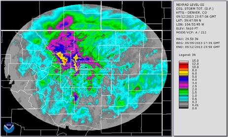
3 KFTG 9/11 20Z 9/12 03Z More on meteorology, radar loop Our tools continued... data buoys for marine observations surface observing systems, such as automated surface stations (ASOS), cooperative observer sites The data collected inform sophisticated environmental prediction models running on high-speed supercomputers. AWIPS workstations allow us to analyze all of these data to issue public, aviation, marine, fire weather, air quality, space weather, river and flood forecasts and warnings around the clock. A high-speed communications hub allows for the efficient exchange of these data and products between NWS components, partners, and customers. AWIPS workstation 3


")
4 Ingredients to daily weather Courtesy: Ian Wittmeyer March 18, z (11am MST) 500 mb and satellite 4


5 March 18, 2003 surface map at 0500 MST March deep upslope snow March 17-19, HEAVY WET SNOW AND DRIFTING SNOW BROUGHT TRANSPORTATION TO A NEAR STANDSTILL. HUNDREDS OF ROOFS COLLAPSED WITH MANY DOWNED TREES AND POWER LINES. UP TO 135,000 PEOPLE LOST POWER FOR DAYS. DIA WAS CLOSED...STRANDING ABOUT 4000 TRAVELERS. THE HEAVY SNOW TRAPPED THOUSANDS OF RESIDENTS IN FOOTHILLS HOMES IN JEFFERSON COUNTY FOR SEVERAL DAYS. THE STORM DUMPED 31.8 INCHES OF SNOW AT THE SITE OF THE FORMER STAPLETON AIRPORT. THE STORM MADE MARCH 2003 THE SNOWIEST MARCH ON RECORD. THE 22.9 INCHES OF SNOW WAS THE GREATEST 24 HOUR SNOWFALL EVER RECORDED IN THE CITY IN MARCH. 5
6 A few more weeks of winter! Heavy snow mountains 8 inches or more in 12 hours, 12 inches or more in 24 hours. Lower elevations 6 inches or more in 12 hours 8 inches or more in 24 hours. Winter storm watch conditions are favorable for the development of hazardous winter weather conditions. Usually issued hours in advance of storm. Winter storm warning the development of hazardous winter weather conditions is likely, usually within the next 24 hours. More winter Blizzard Warning considerable falling or blowing snow with visibilities less than ¼ of a mile AND sustained winds of 35 mph on plains, or 50 mph in mountains. High winds mountains, in and near foothills sustained winds of 50 mph with gusts to 75 mph. lower elevations sustained winds of 40 mph with gusts to 58 mph. Advisories For Sleet Freezing drizzle Blowing snow snow Snow and blowing snow Wind chill Fog Frost Blowing dust Dense smoke Ashfall Freezing fog 6
7 Where do you get your weather forecasts? Television? Radio? Internet? Private vendor site? NOAA sites? NOAA Weather Radio? Other sources? Spotters The Warning Process Citizens Spotter report Radar info Receive and respond NWS vendors Radio TV Sirens Analyze information Issue warning EAS WEA Cell phones NOAA All Hazards Weather Radio Internet Dispatch CCIC, NWR METS, NAWAS EMWIN What s Available from your National Weather Service Forecasts/ Watches/ Warnings National/ local warning maps High Resolution Digital Forecasts Point and Click Forecast Tabular Forecasts NOAA All Hazards Weather Radio 7


8 Your Forecast is just a click away Select your location on the map by a single click to get the forecast for your area Point and Click Forecast From the home page, just click on your location This will provide you with the forecast for your location 8


9 The Weather Story available at NOAA All Hazards Weather Radio Latest radar information 9

 Hurricanes/ Tropical")

10 What s Available from your National Weather Service National Centers Severe Weather Srorm Prediction Center (SPC) Hurricanes/ Tropical Storms National Hurricane Center Fire Weather Climate Climate Prediction Center 10


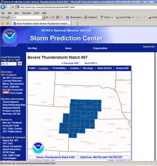
11 NWS National Centers NWS Storm Prediction Center Convective Outlook NWS National Centers NWS Storm Prediction Center Counties in watch 11


12 Storm based warnings BULLETIN - IMMEDIATE BROADCAST REQUESTED SEVERE THUNDERSTORM WARNING NATIONAL WEATHER SERVICE DENVER CO 706 PM MDT WED JUN THE NATIONAL WEATHER SERVICE IN DENVER HAS ISSUED A SEVERE THUNDERSTORM WARNING FOR... EAST CENTRAL DENVER COUNTY IN NORTHEAST COLORADO... WESTERN ADAMS COUNTY IN NORTHEAST COLORADO... * UNTIL 730 PM MDT * AT 706 PM MDT...A SEVERE THUNDERSTORM WAS LOCATED OVER EASTERN COMMERCE CITY...OR 13 MILES NORTHEAST OF DENVER...MOVING NORTHEAST AT 45 MPH. HAZARD...QUARTER SIZE HAIL. SOURCE...RADAR AND SPOTTER INDICATED. IMPACT...DAMAGE TO VEHICLES IS EXPECTED. * LOCATIONS IMPACTED INCLUDE... NORTHEASTERN DENVER...NORTHWESTERN AURORA...COMMERCE CITY... BRIGHTON...DENVER INTERNATIONAL AIRPORT AND D.I.A. TERMINAL AND CONCOURSES. NWS National Centers NWS National Hurricane Center Main page showing Current tropical Storms. 12


13 NWS National Centers NWS National Hurricane Center 5 day forecast of a tropical storm. National Centers Climate Prediction Center Two week forecasts National Centers: Climate Prediction Center one month outlook for temperature and precipitation And precipitation. 13
 networks COCOrahs network Emergency")

14 Our partners! US Drought Monitor Precipitation (Alert) networks COCOrahs network Emergency managers Spotter networks CoCoRaHS Started in Colorado, it is expanding to the whole country. The Farm Service Agency (FSA) implemented CoCoRaH s as their official rainfall reporting system. CocoRahs statewide rainfall 14


15 CoCoRahs Denver metro precipitation reports 02/02/07 Some important radar issues 15


16 HEIGHT WITH DISTANCE OF CENTER OF RADAR BEAM ABOVE GROUND. Location Distance 0.5 degrees 1.5 degrees Fort Morgan 44NM 4942 ft ft. Akron 66NM 7100 ft. 14,030 ft. Sterling 80NM 9926 ft. 18,336 ft. Holyoke 114NM 16,265 ft. 28,307 ft Base reflectivity 16
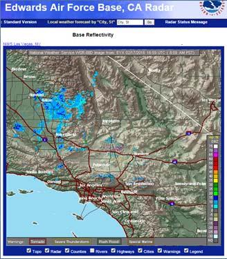

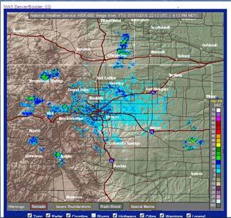
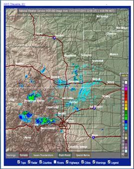
17 Base reflectivity vs Composite Reflectivity Radar comparison, one near one far Precipitation products: 17


 120 nm .")
 Large")
18 Base velocity Circulations within one beam width not detected Detected Not detected RDA WSR-88D beam spreads with distance 60 nm distance nm wide (3040 ft) 120 nm distance... 1 nm wide (6080 ft) 180 nm distance nm wide (9120 ft) Large rotation vs small rotation 18
19 Dual pol radar information Helps identify type of precipitation Shows areas of heavy rain. Before using this information check out the online training: 19
Severe Weather Watches, Advisories & Warnings
 Severe Weather Watches, Advisories & Warnings Tornado Watch Issued by the Storm Prediction Center when conditions are favorable for the development of severe thunderstorms and tornadoes over a larger-scale
SPEARFISH FIRE DEPARTMENT POLICIES AND PROCEDURES
 SPEARFISH FIRE DEPARTMENT POLICIES AND PROCEDURES Page 1 of 5 Volume: Operation Section: 20.00 Number: 20.09 Subject: Weather Watches, Warnings, Advisory s and Spotter Activation Date Issued: 28 March
National Weather Service Greenville-Spartanburg, Forecast Office
 National Weather Service Greenville-Spartanburg, Forecast Office CoCoRaHS Presentation: NC CERT Conference May, 2017 Introduction- who we are. Federal Agency Within the U.S. Dept. of Commerce Introduction-
NWS Resources For Public Works
 NWS Resources For Public Works August 28th, 2016 Shawn DeVinny shawn.devinny@noaa.gov Meteorologist National Weather Service Twin Cities/Chanhassen, MN 1 APWA 2016 PWX 8/28/2016 National Weather Service
Winter Weather. National Weather Service Buffalo, NY
 Winter Weather National Weather Service Buffalo, NY Average Seasonal Snowfall SNOWFALL = BIG IMPACTS School / government / business closures Airport shutdowns/delays Traffic accidents with injuries/fatalities
CHAPTER 13 WEATHER ANALYSIS AND FORECASTING MULTIPLE CHOICE QUESTIONS
 CHAPTER 13 WEATHER ANALYSIS AND FORECASTING MULTIPLE CHOICE QUESTIONS 1. The atmosphere is a continuous fluid that envelops the globe, so that weather observation, analysis, and forecasting require international
Unit 5: NWS Hazardous Weather Products. Hazardous Weather and Flooding Preparedness
 Unit 5: NWS Hazardous Weather Products Objectives Describe the mission of the NWS Describe the basic organizational structure of the NWS Explain the purpose of various NWS products Explain how Probability
Charles Kuster Leadville, CO. Personal Overview
 Charles Kuster Leadville, CO Personal Overview Personal Overview Charles Kuster Leadville, CO OU to study meteorology Charles Kuster Leadville, CO Personal Overview OU to study meteorology Graduated in
We Had No Warning An Overview of Available Forecast Products Before and During Severe Weather Events
 We Had No Warning An Overview of Available Forecast Products Before and During Severe Weather Events Two main sources for severe weather info NOAA/NWS Storm Prediction Center (SPC) Convective Outlooks
WEATHER FORECASTING Acquisition of Weather Information WFO Regions Weather Forecasting Tools Weather Forecasting Tools Weather Forecasting Methods
 1 2 3 4 5 6 7 8 WEATHER FORECASTING Chapter 13 Acquisition of Weather Information 10,000 land-based stations, hundreds of ships and buoys; four times a day, airports hourly Upper level: radiosonde, aircraft,
Snow Measurement Guidelines for National Weather Service Snow Spotters
 Snow Measurement Guidelines for National Weather Service Snow Spotters National Weather Service Forecast Office Northern Indiana October 2004 Table of Contents Introduction 3 Definitions.. 3 Relaying Real
Complete Weather Intelligence for Public Safety from DTN
 Complete Weather Intelligence for Public Safety from DTN September 2017 White Paper www.dtn.com / 1.800.610.0777 From flooding to tornados to severe winter storms, the threats to public safety from weather-related
NOAA s National Weather Service. National Weather Service
 NOAA s National Weather Service Serving the Nation s Environmental Forecasting Needs Lynn Maximuk Regional Director National Weather Service Central Region Headquarters Kansas City, Missouri America s
CoCoRaHS. Community Collaborative Rain, Hail, & Snow Network. Ashley Wolf Meteorologist NWS Green Bay Northeast Wisconsin CoCoRaHS Coordinator
 CoCoRaHS Community Collaborative Rain, Hail, & Snow Network Ashley Wolf Meteorologist NWS Green Bay Northeast Wisconsin CoCoRaHS Coordinator What is CoCoRaHS Who, What, Where and Whys of CoCoRaHS What?
Wind Events. Flooding Events. T-Storm Events. Awareness Alerts / Potential Alerts / Action Alerts / Immediate Action Alerts / Emergency Alerts.
 Information Updated: February of 2016 Our Alert Terms Definitions * Use exactly as seen below * Wind Events Awareness Alert - Strong Winds Potential Alert - Damaging Winds ACTION Alert - Damaging Winds
The Weather Wire. Contents: Summer 2018 Outlook. Summer 2018 Outlook Drought Monitor May Summary/Statistics June Preview Rainfall Totals
 The Weather Wire June 2018 Volume 25 Number 6 Contents: Summer 2018 Outlook Drought Monitor May Summary/Statistics June Preview Rainfall Totals Summer 2018 Outlook June 1 st marked the first day of meteorological
NWS Resources For School Districts
 NWS Resources For School Districts January 23rd, 2017 Shawn DeVinny shawn.devinny@noaa.gov Meteorologist National Weather Service Twin Cities/Chanhassen, MN Outline Watches/Warnings/Advisories Example
Exercise Brunswick ALPHA 2018
 ALPHA Exercise Brunswick ALPHA 2018 Who we are (our structure) What we do (our forecasts) How you can access the information Tropical cyclone information (basic) Overview of the products used for Exercise
Eastern Shore Weather and Climate. Bill Sammler Warning Coordination Meteorologist National Weather Service Wakefield, VA
 Eastern Shore Weather and Climate Bill Sammler Warning Coordination Meteorologist National Weather Service Wakefield, VA About The NWS The National Weather Service is: A Federal Government Agency Part
IWT Scenario 2 Integrated Warning Team Workshop National Weather Service Albany, NY October 31, 2014
 IWT Scenario 2 Integrated Warning Team Workshop National Weather Service Albany, NY October 31, 2014 09 10 11 12 13 Scenario 2 Timeline December 9-13 Tue Wed Thu Fri Sat Tue, Dec. 9 @ 5 am 2014 2014 2014
Preparing For Winter Weather At Home & In The Workplace. Brandon Peloquin, Warning Coordination Meteorologist NWS Wilmington OH
 Preparing For Winter Weather At Home & In The Workplace Brandon Peloquin, Warning Coordination Meteorologist NWS Wilmington OH What We Will Talk About Introduction to the National Weather Service How we
How to Effectively Use Weather Radar. Presented by: Robert Reale Company:
 How to Effectively Use Weather Radar Presented by: Robert Reale Company: Who Am I? What is WeatherWorks? WeatherWorks Private weather consulting firm located in Hackettstown, NJ Over 30 years in the snow
DEPARTMENT OF EARTH & CLIMATE SCIENCES SAN FRANCISCO STATE UNIVERSITY. Metr Fall 2014 Test #1 September 30, 2014
 DEPARTMENT OF EARTH & CLIMATE SCIENCES SAN FRANCISCO STATE UNIVERSITY NAME Metr 302.02 Fall 2014 Test #1 September 30, 2014 200 pts (4 pts each answer) Part I. Surface Chart Interpretation. Questions 1
October 2015 Volume 22 Number 10
 The Weather Wire October 2015 Volume 22 Number 10 Contents: Local Frost/Freeze Information Drought Monitor September Summary/Statistics October Preview Rainfall Totals Local Frost Freeze Information Many
Building a Weather-Ready Wisconsin
 National Weather Service Session: Building a Weather-Ready Wisconsin WEMA Conference October 11, 2017 Jeff Last National Weather Service Green Bay Today s Presentation NWSChat in EM Operations The June
May 2016 Volume 23 Number 5
 The Weather Wire May 2016 Volume 23 Number 5 Contents: Winter Summary Current Colorado and West-wide Snow Pack Drought Monitor April Summary/Statistics May Preview Snowfall Totals Winter Summary The Front
WINTER STORM Annex II
 WINTER STORM Annex II I. PURPOSE A. This annex has been prepared to ensure a coordinated response by state agencies to requests from local jurisdictions to reduce potential loss of life and to ensure essential
United States Multi-Hazard Early Warning System
 United States Multi-Hazard Early Warning System Saving Lives Through Partnership Lynn Maximuk National Weather Service Director, Central Region Kansas City, Missouri America s s Weather Enterprise: Protecting
UDOT Weather Program Traffic Operations Center
 UDOT Weather Program Traffic Operations Center Presentation Goals You MUST account for weather in your Traffic Management program Provide you with information on proven tools and strategies You NEED a
National Weather Service. Building a Weather Ready Nation
 National Weather Service Building a Weather Ready Nation The NWS is a federal agency Department of Commerce National Oceanic and Atmospheric Administration National Weather Service Today s National Weather
Significant Flooding Expected
 Significant Flooding Expected Decision Support Briefing #5 As of: 9:00 AM September 14, 2018 What Has Changed? Flash Flood Watch now in effect for part of area, will be expanded later today 9/14/2018 9:23
SAMPLE. SITE SPECIFIC WEATHER ANALYSIS Wind Report. Robinson, Smith & Walsh. John Smith. July 1, 2017 REFERENCE: 1 Maple Street, Houston, TX 77034
 SAMPLE SITE SPECIFIC WEATHER ANALYSIS Wind Report PREPARED FOR: Robinson, Smith & Walsh John Smith July 1, 2017 REFERENCE: JACK HIGGINS / 4151559-01 1 Maple Street, Houston, TX 77034 CompuWeather Sample
WEATHER. rain. thunder. The explosive sound of air as it is heated by lightning.
 WEATHER rain thunder The explosive sound of air as it is heated by lightning. rainbow lightning hurricane They are intense storms with swirling winds up to 150 miles per hour. tornado cold front warm front
IWT Scenario 1 Integrated Warning Team Workshop National Weather Service Albany, NY October 31, 2014
 Integrated Warning Team Workshop National Weather Service Albany, NY October 31, 2014 23 24 25 26 27 Scenario 1 Timeline November 23-27 Sun Mon Tue Wed Thu Thanksgiving Day Sunday, Nov. 23 @ 430 pm NWS
GC Briefing. Weather Sentinel Tropical Storm Michael. Status at 8 AM EDT (12 UTC) Today (NHC) Discussion. October 11, 2018
 Today (NHC) Discussion. October 11, 2018") GC Briefing Weather Sentinel Tropical Storm Michael October 11, 2018 After making landfall as a high-end category-4 hurricane on the Florida Panhandle, Michael weakened to tropical storm status early this
GC Briefing Weather Sentinel Tropical Storm Michael October 11, 2018 After making landfall as a high-end category-4 hurricane on the Florida Panhandle, Michael weakened to tropical storm status early this
Village Weather, Snow, Ice, Breakup, Flooding, Fire sites
 Village Weather, Snow, Ice, Breakup, Flooding, Fire sites What is the weather like now in Villages?... 1 BREAKUP:... 2 Flooding... 3 Fires... 5 Weather Predictability, Weather and Ice Advisories and How
Meteorological alert system in NMS of Mongolia
 Meteorological alert system in NMS of Mongolia L.Oyunjargal, NAMEM Regional Workshop on Impact-based Forecasts in Asia Seoul, Korea, 07-09 NOV 2017 Weather related disasters 1. Strong wind and snow and
A Prepared Marylander Creates a Resilient Maryland
 Maryland Emergency Management Agency Operations Directorate Hazardous Winter Weather Outlook Briefing March 5, 2013 0800 A Prepared Marylander Creates a Resilient Maryland A strong low pressure will track
July 24, 2017 Annapolis, MD Bryan A. Jackson NWS Sterling, VA Marine Program Leader
 When Wicked Weather Strikes Insights into Chesapeake Bay Weather July 24, 2017 Annapolis, MD Bryan A. Jackson NWS Sterling, VA Marine Program Leader Mission of the National Weather Service Provide climate,
Colorado CoCoRaHS. Colorado CoCoRaHS. Because Every Drop Counts! November 2014 Volume 2, Issue 11
 U.S. PRECIPITATION (% OF AVERAGE) LOOKING BACK AT OCTOBER 2014 October was a fairly dry month for much of the nation with the exception of the Pacific Northwest, portions of New England and the Tennessee
Weather versus Climate: What is the difference? Sources of Weather Information
 Joel O. Paz, Extension Agrometerologist and Gerrit Hoogenboom, Professor & REI Coordinator Department of Biological and Agricultural Engineering Weather versus Climate: What is the difference? The difference
HAZARD DESCRIPTION... 1 LOCATION... 1 EXTENT... 1 HISTORICAL OCCURRENCES...
 WINTER STORM HAZARD DESCRIPTION... 1 LOCATION... 1 EXTENT... 1 HISTORICAL OCCURRENCES... 3 SIGNIFICANT PAST EVENTS... 4 PROBABILITY OF FUTURE EVENTS... 5 VULNERABILITY AND IMPACT... 5 Hazard Description
Arizona Climate Summary March 2013
 Arizona Climate Summary March 2013 Summary of conditions for February 2013 February 2013 Temperature and Precipitation Summary February 1 st 16 th : February began with a ridge of high pressure over the
Weather vs. Climate. Tucson NWS homepage:
 Weather vs. Climate Tucson NWS homepage: www.nws.noaa.gov/twc/ A Weather Forecaster? Betty claims to know exactly when it s going to rain because her knee starts to hurt. Ms. Betty Martin of Newburgh,
Weather Briefing for Pennsylvania Feb Outlook Prepared 02/11/14 2 pm EST
 Weather Briefing for Pennsylvania Feb. 12-13 Outlook Prepared 02/11/14 2 pm EST Prepared by: National Weather Service State College, PA (Peter.Jung@noaa.gov) Pennsylvania Weather Overview A significant
KCCI SchoolNet8 Workshop
 KCCI SchoolNet8 Workshop Daryl Herzmann Iowa Environmental Mesonet Iowa State University The Rundown CIPCO/IEM/KCCI/NWS partnership Who is using your data? IEM Tracker (a.k.a. spam generator) Downloading
The Weather Wire. Current Colorado Snowpack. Contents:
 The Weather Wire January 2019 Volume 26 Number 1 Contents: Current Colorado Snowpack Denver Snowfall Since 1999-2000 Denver 2018 Climate Review Drought Monitor December Summary/Statistics January Preview
Dr. Amanda Schroeder. NWS Weather Forecast Office Fort Worth, TX. Sustainable Urban Water Workshop University of Texas-Arlington June 4-5, 2015
 Dr. Amanda Schroeder NWS Weather Forecast Office Fort Worth, TX Sustainable Urban Water Workshop University of Texas-Arlington June 4-5, 2015 Outline Communicating the message - official Flood and Flash
Winter Storm Briefing #3 Monday Evening Wednesday Evening
 Winter Storm Briefing #3 Monday Evening Wednesday Evening Tuesday March 14, 2017 Disclaimer: The information contained within this briefing is time-sensitive. Do not use after 4AM Wednesday. Applies to
Tropical Update. 5 AM EDT Tuesday, September 12, 2017 Post-Tropical Cyclone Irma, Hurricane Jose, & Tropical Wave (10%)
") Tropical Update 5 AM EDT Tuesday, September 12, 2017 Post-Tropical Cyclone Irma, Hurricane Jose, & Tropical Wave (10%) This update is intended for government and emergency response officials, and is provided
Tropical Update 5 AM EDT Tuesday, September 12, 2017 Post-Tropical Cyclone Irma, Hurricane Jose, & Tropical Wave (10%) This update is intended for government and emergency response officials, and is provided
Weather Studies Introduction to Atmospheric Science
 Weather Studies Introduction to Atmospheric Science American Meteorological Society Chapter 1 Monitoring The Weather Credit: This presentation was prepared for AMS by Michael Leach, Professor of Geography
1st Annual Southwest Ohio Snow Conference April 8, 2010 Abner F. Johnson, Office of Maintenance - RWIS Coordinator
 1st Annual Southwest Ohio Snow Conference April 8, 2010 Abner F. Johnson, Office of Maintenance - RWIS Coordinator The Ohio Department of Transportation ODOT has approximately 5500 full-time employees
The Climate of Payne County
 The Climate of Payne County Payne County is part of the Central Great Plains in the west, encompassing some of the best agricultural land in Oklahoma. Payne County is also part of the Crosstimbers in the
Coastal Storm. Wednesday through Friday, 3/6-8/2013 Weather Briefing
 Coastal Storm Wednesday through Friday, 3/6-8/2013 Weather Briefing Prepared 2:00 PM EST Wednesday, March 6, 2013 National Weather Service New York, NY Purpose of Briefing Promote Situational Awareness
Issued by: National Weather Service San Joaquin Valley - Hanford CA. Issue time: 409 AM PST Wed Jan
 Forecast Information Location: New_Exchequer_Dam Updated: January 16, 2019, 11:45 am NWS Weather Discussion: Issued by: National Weather Service San Joaquin Valley - Hanford CA Issue time: 409 AM PST Wed
The Climate of Marshall County
 The Climate of Marshall County Marshall County is part of the Crosstimbers. This region is a transition region from the Central Great Plains to the more irregular terrain of southeastern Oklahoma. Average
2018 Year in Review for Central and Southeast Illinois By: Chris Geelhart, Meteorologist National Weather Service, Lincoln IL
 By: Chris Geelhart, Meteorologist National Weather Service, Lincoln IL While 2018 featured some significant out-of-season weather, including below zero temperatures in April and 90-degree highs in early
 STATE OF WISCONSIN/ DEPARTMENT OF MILITARY AFFAIRS WISCONSIN EMERGENCY MANAGEMENT 2400 WRIGHT STREET P.O. BOX 7865 MADISON, WISCONSIN 53707-7865 608-242-3232 February 22, 2007 Re: Tornado and Severe Weather
The Climate of Murray County
 The Climate of Murray County Murray County is part of the Crosstimbers. This region is a transition between prairies and the mountains of southeastern Oklahoma. Average annual precipitation ranges from
The Weather Wire. Contents: Wildfires Burning Across Colorado
 The Weather Wire July 2018 Volume 25 Number 7 Contents: Wildfires Burning Across Colorado Drought Monitor June Summary/Statistics July Preview Rainfall Totals Wildfires Burning Across Colorado Following
CoCoRaHS. Citizens monitoring precipitation in their backyards... filling in the gaps
 CoCoRaHS Citizens monitoring precipitation in their backyards... filling in the gaps What Is CoCoRaHS?? CoCoRaHS is a grassroots, non-profit, community-based, high-density precipitation network made up
Winter Maintenance Report
 98.4 Official State Snowfall 150 Truck Stations 1,813 Full-time and Backup Snowfighters 840 Plow trucks - includes 47 reserve plows 30,585 Lane Miles 85% Frequency Achieving Bare Lanes 2017-18 Winter Maintenance
The Climate of Grady County
 The Climate of Grady County Grady County is part of the Central Great Plains, encompassing some of the best agricultural land in Oklahoma. Average annual precipitation ranges from about 33 inches in northern
Colorado CoCoRaHS. Colorado CoCoRaHS. December 2013 Volume 1, Issue 8 NOVEMBER PRECIPITATION NOVEMBER TEMPERATURES
 NOVEMBER PRECIPITATION The month of November brought a flip-flop in precipitation patterns to some areas compared to the previous month, especially for locations in the foothills north of I-70 and in south-central
California OES Weather Threat Briefing
 California OES Weather Threat Briefing Wednesday, January 16, 2019 9:00 AM PST Day 1: Strong winds, heavy mountain snow and heavy rain with isolated thunderstorms across much of the state through Thursday
Hazard Warnings and Warning Systems
 Hazard Warnings and Warning Systems Lecture Objectives: -Know the main features and limitations of our national warning system -learn the key features of an effective warning system Sorensen, J.H. (2000)
Coastal Storm this Weekend
 Weather Briefing Prepared 9 AM EST Feb 5, 2010 Joe Miketta Warning Coordination Meteorologist NOAA s National Weather Service Philadelphia/Mt. Holly NJ Forecast Office 609-261 261-6602 6602 x223 Joseph.Miketta@noaa.gov
Severe Weather Hazards Are Real
 Severe Weather Hazards Are Real In the past 10 years, more than 40 people have died and dozens more injured as a result of weatherrelated events in Minnesota (not including motor vehicles.) The top severe
Local Precipitation Variability
 Local Precipitation Variability Precipitation from one storm can vary from neighborhood to neighborhood. What falls in your yard may not fall in the next. The next time it rains see how the precipitation
The Weather Wire. Current Colorado Snowpack. Contents:
 The Weather Wire December 2018 Volume 25 Number 12 Contents: Current Colorado Snowpack Drought Monitor November Summary/Statistics December Preview Snowfall Totals Current Colorado Snowpack Although snowfall
Spatial Optimization of CoCoRAHS Network in Tennessee. Joanne Logan Department of Biosystems Engineering and Soil Science University of Tennessee
 Spatial Optimization of CoCoRAHS Network in Tennessee Joanne Logan Department of Biosystems Engineering and Soil Science University of Tennessee Abstract CoCoRaHS (Community Collaborative Rain, Hail and
The Weather Wire. Contents: Hail in Colorado. Hail in Colorado Drought Monitor June Summary/Statistics July Preview Rainfall Totals
 The Weather Wire July 2016 Volume 23 Number 7 Contents: Hail in Colorado Drought Monitor June Summary/Statistics July Preview Rainfall Totals Hail in Colorado Anyone who has lived in Colorado for long
The Climate of Seminole County
 The Climate of Seminole County Seminole County is part of the Crosstimbers. This region is a transition region from the Central Great Plains to the more irregular terrain of southeastern Oklahoma. Average
 Hazard Warnings GE 4150 Natural Hazards September 17, 2007 http://www.sdr.gov/ndis_rev_oct27.pdf Sorensen, J.H. (2000) Hazard warning systems: Review of 20 years of progress. Natural Hazards Review, May,
P1.25 OK-WARN: OKLAHOMA WEATHER ALERT REMOTE NOTIFICATION. Vincent T. Wood NOAA/OAR/National Severe Storms Laboratory Norman, Oklahoma
 P1.25 OK-WARN: OKLAHOMA WEATHER ALERT REMOTE NOTIFICATION Vincent T. Wood NOAA/OAR/National Severe Storms Laboratory Norman, Oklahoma 1. INTRODUCTION OKlahoma Weather Alert Remote Notification (OK-WARN)
Major Winter Storm to impact Western Washington. 17 January 2012 National Weather Service Seattle/Tacoma
 Major Winter Storm to impact Western Washington 17 January 2012 National Weather Service Seattle/Tacoma Current Warnings Winter Storm Warning for all of Western Washington, except: Northwest interior Extreme
New Forecast Section. connection. Volume 3 Issue 4 April 2012
 Volume 3 Issue 4 April 2012 connection www.mesonet.org New Forecast Section Spring has arrived, and so has storm season. For many, that means monitoring the weather and forecast more. To help users prepare
Weather Compass Webquest: Lab/Activity Edition
 Weather Compass Webquest: Lab/Activity Edition www.weathercompass.webs.com 1 Name: Date: Welcome to the Weather Compass Webquest: Activity/Lab Edition. This webquest was created by the National Oceanic
Name of University Researcher Preparing Report: Robert Cifelli. Name of NWS/DOT Researcher Preparing Report: Chad Gimmestad
 University: Colorado State University Name of University Researcher Preparing Report: Robert Cifelli NWS Office: WFO Boulder Name of NWS/DOT Researcher Preparing Report: Chad Gimmestad Partners or Cooperative
GC Briefing. Weather Sentinel Hurricane Florence. Status at 5 PM EDT (21 UTC) Today (NHC) Discussion. September 13, 2018
 Today (NHC) Discussion. September 13, 2018") GC Briefing September 13, 2018 Weather Sentinel Hurricane Florence Tropical storm conditions have been reported for areas of North Carolina and will continue to spread inland to the west and south. Hurricane
GC Briefing September 13, 2018 Weather Sentinel Hurricane Florence Tropical storm conditions have been reported for areas of North Carolina and will continue to spread inland to the west and south. Hurricane
The Climate of Texas County
 The Climate of Texas County Texas County is part of the Western High Plains in the north and west and the Southwestern Tablelands in the east. The Western High Plains are characterized by abundant cropland
Daily Operations Briefing Friday, May 8, :30 a.m. EDT
 Daily Operations Briefing Friday, May 8, 2015 8:30 a.m. EDT Significant Activity: May 7-8 Significant Events: Severe weather Central/Southern Plains Tropical Activity: Atlantic: Subtropical Storm Ana Western
GEOL 308 Natural Hazards Activity 2: Weather and Flooding
 DUE Tuesday February 7 Note: You will need to complete Part I by February 3! Part I: Weather Visit http://www.weather.gov This is the National Weather Service site. It includes a quick overview of national
W I N T E R STORM HAZARD DESCRIPTION
 W I N T E R STORM HAZARD DESCRIPTION... 1 LOCATION... 2 EXTENT... 2 HISTORICAL OCCURRENCES... 4 SIGNIFICANT PAST EVENTS... 4 PROBABILITY OF FUTURE EVENTS... 5 VULNERABILITY AND IMPACT... 5 HAZARD DESCRIPTION
Storm Summary for Hurricane Jose
 Storm Summary for Hurricane Jose Tuesday, September 19, 2017 at 11 AM EDT (Output from Hurrevac, based on National Hurricane Center Forecast Advisory #57) Jose is currently a Category 1 hurricane on the
U.S. WIND, SCS, FLOOD, WINTER WEATHER
 U.S. WIND, SCS, FLOOD, WINTER WEATHER The threat continues for strong winds, heavy snow, heavy rain and severe thunderstorms according to the U.S. National Weather Service (NWS). The threat comes with
10 years after Hurricane Charley
 10 years after Hurricane Charley Hurricane Charley (2004) A Retrospective Scott M. Spratt Warning Coordination Meteorologist NWS Melbourne, FL Florida Governors Hurricane Conference May 15, 2014 11 AM
SAMPLE. SITE SPECIFIC WEATHER ANALYSIS Rainfall Report. Bevins Engineering, Inc. Susan M. Benedict. July 1, 2017 REFERENCE:
 SAMPLE SITE SPECIFIC WEATHER ANALYSIS Rainfall Report PREPARED FOR: Bevins Engineering, Inc. Susan M. Benedict July 1, 2017 REFERENCE: DUBOWSKI RESIDENCE / FILE# 11511033 1500 Water Street, Pensacola,
THE COMMUNITY COLLABORATIVE RAIN, HAIL AND SNOW NETWORK (COCORAHS) A GREAT WAY TO LEARN AND TEACH ABOUT OUR CLIMATE
 A GREAT WAY TO LEARN AND TEACH ABOUT OUR CLIMATE") J2.2 THE COMMUNITY COLLABORATIVE RAIN, HAIL AND SNOW NETWORK (COCORAHS) A GREAT WAY TO LEARN AND TEACH ABOUT OUR CLIMATE Henry W. Reges*, Robert C. Cifelli, and Nolan J. Doesken. CoCoRaHS/Colorado State
J2.2 THE COMMUNITY COLLABORATIVE RAIN, HAIL AND SNOW NETWORK (COCORAHS) A GREAT WAY TO LEARN AND TEACH ABOUT OUR CLIMATE Henry W. Reges*, Robert C. Cifelli, and Nolan J. Doesken. CoCoRaHS/Colorado State
2003 Water Year Wrap-Up and Look Ahead
 2003 Water Year Wrap-Up and Look Ahead Nolan Doesken Colorado Climate Center Prepared by Odie Bliss http://ccc.atmos.colostate.edu Colorado Average Annual Precipitation Map South Platte Average Precipitation
KANSAS CLIMATE SUMMARY April 2017
 KANSAS CLIMATE SUMMARY April 2017 Epic Blizzard While much of the month was warmer than normal, the last week brought a return to cold, wintery weather in the western third of the state, and cold rainy
Tropical Update. 11 AM EDT Wednesday, October 10, 2018 Hurricane Michael, Hurricane Leslie & Tropical Storm Nadine, Caribbean Low (40%)
") Tropical Update 11 AM EDT Wednesday, October 10, 2018 Hurricane Michael, Hurricane Leslie & Tropical Storm Nadine, Caribbean Low (40%) This update is intended for government and emergency response officials,
Tropical Update 11 AM EDT Wednesday, October 10, 2018 Hurricane Michael, Hurricane Leslie & Tropical Storm Nadine, Caribbean Low (40%) This update is intended for government and emergency response officials,
The Climate of Kiowa County
 The Climate of Kiowa County Kiowa County is part of the Central Great Plains, encompassing some of the best agricultural land in Oklahoma. Average annual precipitation ranges from about 24 inches in northwestern
Jan 7, 2017 Winter Weather Event
 Jan 7, 2017 Winter Weather Event Decision Support Briefing # 5 Assessment for northeast South Carolina & southeast North Carolina National Weather Service Wilmington NC 4 PM EST Friday January 6, 2017
The Climate of Bryan County
 The Climate of Bryan County Bryan County is part of the Crosstimbers throughout most of the county. The extreme eastern portions of Bryan County are part of the Cypress Swamp and Forest. Average annual
Arizona Climate Summary April 2013
 Arizona Climate Summary April 2013 Summary of conditions for March 2013 March 2013 Temperature and Precipitation Summary March 1 st 16 th : March began as a ridge of high pressure progressed across the
The Hydrologic Cycle: How Do River Forecast Centers Measure the Parts?
 The Hydrologic Cycle: How Do River Forecast Centers Measure the Parts? Greg Story Meteorologist National Weather Service Fort Worth, TX Overview n Introduction What is the mission of an RFC? n The Hydrologic
The hydrologic service area (HSA) for this office covers Central Kentucky and South Central Indiana.
 for this office covers Central Kentucky and South Central Indiana.") January 2012 February 13, 2012 An X inside this box indicates that no flooding occurred within this hydrologic service area. January 2012 continued the string of wet months this winter. Rainfall was generally
January 2012 February 13, 2012 An X inside this box indicates that no flooding occurred within this hydrologic service area. January 2012 continued the string of wet months this winter. Rainfall was generally
****Approaching Winter Storm ****
 ****Approaching Winter Storm **** 02/12/2013 The Flemington Borough Office of Emergency Management is currently monitoring the incoming winter storm expected to impact our area starting Thursday morning