Recent ET/STC/TT near Iberian Peninsula and Canary Islands
|
|
|
- Shon Sims
- 5 years ago
- Views:
Transcription

1 Recent ET/STC/TT near Iberian Peninsula and Canary Islands ET, Extratropical Transition STC, SubTropical Cyclogenesis TT, Tropical Transition Francisco Martín and Fermín Elizaga AEMet
2 Recent ET/STC/TT near Iberian Peninsula and Canary Islands Why are we here? In 2005 and 2006, three tropical cyclones,tc, in origin made landfall in Spanish Atlantic areas Two of them suffered a reintensification process during its extratropical transition, ET, generating hazardous weather conditions These are the main reasons!!! 11/02/
3 Recent ET/STC/TT near Iberian Peninsula and Canary Islands Summary Atlantic hurricane seasons close to Spain: a short review Forecasting problems: lessons learned Main actions and activities from INM-AEMet Conclusions 11/02/


4 Recent ET/STC/TT near Iberian Peninsula and Canary Islands Close-up view of historical tracks of tropical cyclones: , but A HISTORICAL ANALOG OF 2005 HURRICANE VINCE BY J. M. VAQUERO, R. GARCÍA-HERRERA, D. WHEELER, M. CHENOWETH, AND C. J. MOCK The passage of Hurricane Vince as a tropical depression over Spain and Portugal was once thought to be a unique historical event, but documents show that a rare tropical storm similarly struck southwest Spain in October Bull. Amer. Meteor. Soc, Feb 2008, /02/

5 Recent ET/STC/TT near Iberian Peninsula and Canary Islands Atlantic hurricane season in 2005 Source, NHC 11/02/

6 Recent ET/STC/TT near Iberian Peninsula and Canary Islands Atlantic hurricane season in 2006 Source, NHC 11/02/
7 Recent ET/STC/TT near Iberian Peninsula and Canary Islands: Best-track of hurricane Vince 8-11 Oct Vince cold convection area Cut-off low Source, NHC

8 Recent ET/STC/TT near Iberian Peninsula and Canary Islands: Best-track of Tropical storm Delta Nov /12Z ET & reintensification Source, NHC

 955 mb 15 17 16 18 19 20 Hurricane (category 3) 21 13 September 2006 20 September 2006 14 25 20 13 12 11 15-65 -60-55")
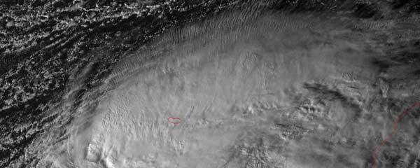
9 Recent ET/STC/TT near Iberian Peninsula and Canary Islands: Best-track of hurricane Gordon Sept Category Hurricane Gordon September 2006 Hurricane Tropical Storm Tropical Dep. Extratropical Subtr. Storm Subtr. Dep. Low / Wave 23 Extratropical cyclone UTC Pos/Date 12 UTC Position PPP Min. press (mb) 955 mb Hurricane (category 3) September September Source, NHC
10 Some internal activities related to TC and ET Updating of tropical training material and bibliography Delta case study: numerical simulations Enhancing some research and operational activities related to (sub)tropical meteorology Cooperation with NHC Participation in some tropical conferences and working groups Revising INM/AEMet warning system
11 Training material: ET and Klein conceptual Problems to resolve in near real time: Uncertainty, errors, or deviation of NWP models: probabilistic forecasts Problems to resolve in near real time: Where is the main precipitation region? Uncertainty, errors, or deviation of NWP models: probabilistic forecasts Where are the wind maxima zones? Local factors: Orographic interactions and local effects!! Where are the main precipitation region and the wind maxima zones? Local factors: Orographic interactions and local effects!!

12 ET properties: COMET modules Source: COMET Source, COMET

13 Training material and future actions: diagram phases Source, Florida State University


14 Tropical storm DELTA A surprising case Nov 2005 TT TC ET Nov 2005

15 Delta and its Extratropical Transition, ET 27/12 Z 28/00 Z 28/12 Z 28/18 Z

16 VIS0.6 MSG1 28 Nov Z Ex Delta and reintensification: a new forecasting challenge Local and orographic effects

17 Wind speeds and maximum gusts in Canary Islands from ex-delta Wind speed Time Gust speed Time Topographically induced wind effects were very important!! Tropical Cyclones: Tropical depressión: wind speed less than 63 km/h Tropical storm: km/h Hurricane: more than 118 km/h

18 Trajectories and forecasting uncertainties: Delta case Set of forecast trajectories of NWP models used at NHC, 25 November 2005 run time. Cyclone positions every six hours Source, NHC (image courtesy Lixion Avila)

19 Trajectories and forecasting uncertainty from ECMWF EPS model Delta case

20 Warning Systems & Meteoalerta for TC and ET at AEMet Before 2006, TC and ET were not specifically included in the INM-AEMet warning systems Currently, TC and ET are considered in the meteorological warning system as a special warning event But its associated wind, precipitation and sea waves are considered in the Spanish Meteoalerta project 1000 km 1000 km Canary Islands
21 Warning Areas for TC and Meteoalerta project Example of Gordon Case Since 2006 coordination between NHC and INM- AEMet forecasting Service (National Forecasting Center) may be established when a TC is approaching to Spain: special warning messages are issued when a TC is close to Spain (distance < 1000 km) Winds, precipitation and sea waves associated with TC or ET are considered in the Spanish Meteoalerta project: Gordon case example

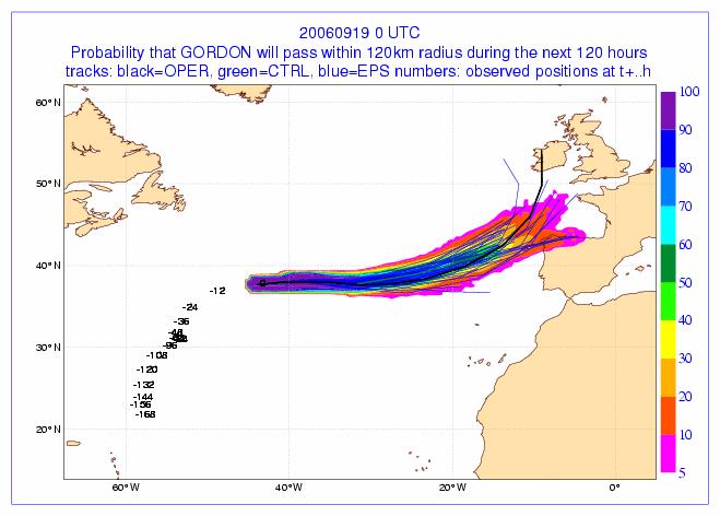
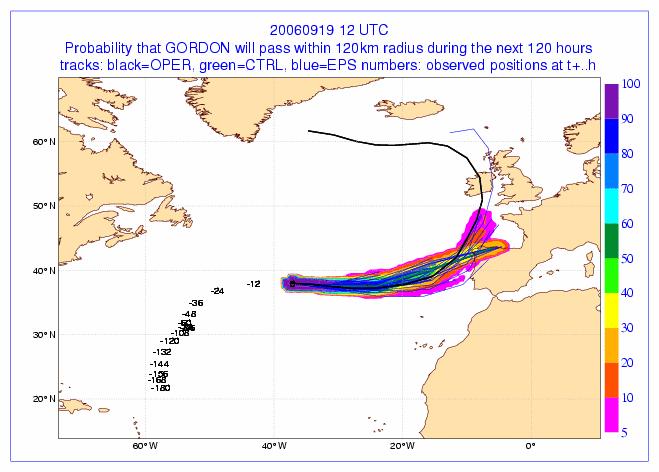

22 Gordon Probability of tracks of ECMWF models: deterministic and EPS
 Affected areas Forecast period")

23 INM s special warnings for TC or ET near Spain BODY of the message: Meteorological phenomena and associated surface-weather conditions (wind, precipitation, waves, ) Affected areas Forecast period Probability of the events Synoptic setting: short description Next special warning and issue time This information is issued by National Forecasting Center to: INM/AEMet web page Media: TV radio, etc. Civil Protection Authorities

24 Meteoalerta: Gordon case Short range warnings D+1 D+2
25 Current and future activities International Workshop about subtropical cyclones and Extropical Transitions to be hold in Madrid (8-9 May 2008) Increase the cooperation with NHC: training courses,lectures,.. To attend technical conferences of WMO AR IV Evaluation campaigns
26 Conclusions Three Atlantic tropical cyclones in origin, (Delta-05 and Gordon-06) or a similar to tropical one (Vince-05), have recently affected Spain AEMet has enhanced its internal and external activities related to tropical and subtropical meteorology as well as forecasting tasks: technical coordination with NHC AEMet is increasing the relationship and cooperation with the technical committees of WMO RA (Regional Association) IV AEMet is promoting tropical/subtropical meteorology courses, lectures, workshops, etc. TC/ET and Spanish Meteoalerta/warning system: AEMet will issue special warning messages when a TC or an ET is taking place near Spain (distance < 1000 km). Surface weather conditions and forecasts are included in our Meteoalarta system Remarks. Tropical and subtropical meteorology in Spain is not just only associated with TC and ET: Spain is affected by other types of tropical/subtropical disturbances
27 Thanks very much for your attention!!
Subtropical and Hybrid Systems IWTC VII Topic 1.6
 Subtropical and Hybrid Systems IWTC VII Topic 1.6 John R. Gyakum Department of Atmospheric and Oceanic Sciences McGill University, Montreal Canada Working group: John L. Beven II, Lance F. Bosart, Fermin
Tropical Storm List
 Tropical Storm Email List http://tstorms.org/ tropical-storms@tstorms.org Tropical-Storms is a mailing list only for those who are professionally active in either the research or forecasting of tropical
The Impact of air-sea interaction on the extratropical transition of tropical cyclones
 The Impact of air-sea interaction on the extratropical transition of tropical cyclones Sarah Jones Institut für Meteorologie und Klimaforschung Universität Karlsruhe / Forschungszentrum Karlsruhe 1. Introduction
Benjamin J. Moore. Education. Professional experience
 Benjamin J. Moore Department of Atmospheric and Environmental Sciences University at Albany, State University of New York 1400 Washington Avenue Albany, New York, 12222 phone: +1 507 398 7427 email: bjmoore@albany.edu
Canadian Hurricane Center: How NHC Products are used to issue Warnings and Communicate Hazards
 Canadian Hurricane Center: How NHC Products are used to issue Warnings and Communicate Hazards Bob Robichaud Warning Preparedness Meteorologist Canadian Hurricane Centre Contents Brief background on the
COLORADO STATE UNIVERSITY FORECAST OF ATLANTIC HURRICANE ACTIVITY FROM AUGUST 17 AUGUST 30, 2012
 COLORADO STATE UNIVERSITY FORECAST OF ATLANTIC HURRICANE ACTIVITY FROM AUGUST 17 AUGUST 30, 2012 We expect that the next two weeks will be characterized by above-average amounts (greater than 130 percent)
SIXTH INTERNATIONAL WORKSHOP on TROPICAL CYCLONES. Working Group: Phillipe Caroff, Jeff Callaghan, James Franklin, Mark DeMaria
 WMO/CAS/WWW Topic 0.1: Track forecasts SIXTH INTERNATIONAL WORKSHOP on TROPICAL CYCLONES Rapporteur: E-mail: Lixion A. Avila NOAA/National Hurricane Center 11691 SW 17th Street Miami, FL 33165-2149, USA
NHC Ocean Vector Winds Update
 NHC Ocean Vector Winds Update Michael J. Brennan NOAA/NWS/NCEP National Hurricane Center International Ocean Vector Winds Science Team Meeting Portland, Oregon, 20 May 2015 Current Status NHC is currently
Tropical Cyclones: When Nature Attacks!! AOSC 200 Tim Canty. Tropical Cyclone: African Easterly Jet
 Tropical Cyclones: When Nature Attacks!! AOSC 200 Tim Canty Class Web Site: http://www.atmos.umd.edu/~tcanty/aosc200 Topics for today: Really powerful low pressure systems Lecture 25 Nov 27 2018 1 Tropical
JMA Contribution to SWFDDP in RAV. (Submitted by Yuki Honda and Masayuki Kyouda, Japan Meteorological Agency) Summary and purpose of document
 Summary and purpose of document") WORLD METEOROLOGICAL ORGANIZATION COMMISSION FOR BASIC SYSTEMS OPAG on DPFS DPFS/RAV-SWFDDP-RSMT Doc. 7.1(1) (28.X.2010) SEVERE WEATHER FORECASTING AND DISASTER RISK REDUCTION DEMONSTRATION PROJECT (SWFDDP)
WORLD METEOROLOGICAL ORGANIZATION COMMISSION FOR BASIC SYSTEMS OPAG on DPFS DPFS/RAV-SWFDDP-RSMT Doc. 7.1(1) (28.X.2010) SEVERE WEATHER FORECASTING AND DISASTER RISK REDUCTION DEMONSTRATION PROJECT (SWFDDP)
COLORADO STATE UNIVERSITY FORECAST OF ATLANTIC HURRICANE ACTIVITY FROM AUGUST 4-17, 2015
 COLORADO STATE UNIVERSITY FORECAST OF ATLANTIC HURRICANE ACTIVITY FROM AUGUST 4-17, 2015 We expect that the next two weeks will be characterized by below-average amounts (
Outlook 2008 Atlantic Hurricane Season. Kevin Lipton, Ingrid Amberger National Weather Service Albany, New York
 Outlook 2008 Atlantic Hurricane Season Kevin Lipton, Ingrid Amberger National Weather Service Albany, New York Summary 2007 Hurricane Season Two hurricanes made landfall in the Atlantic Basin at category-5
COLORADO STATE UNIVERSITY FORECAST OF ATLANTIC HURRICANE ACTIVITY FROM OCTOBER 13 OCTOBER 26, 2017
 COLORADO STATE UNIVERSITY FORECAST OF ATLANTIC HURRICANE ACTIVITY FROM OCTOBER 13 OCTOBER 26, 2017 We expect that the next two weeks will be characterized by above-normal hurricane activity. (as of 13
COLORADO STATE UNIVERSITY FORECAST OF ATLANTIC HURRICANE ACTIVITY FROM AUGUST 16 AUGUST 29, 2013
 COLORADO STATE UNIVERSITY FORECAST OF ATLANTIC HURRICANE ACTIVITY FROM AUGUST 16 AUGUST 29, 2013 We expect that the next two weeks will be characterized by above-average amounts (greater than 130 percent)
Tropical Waves. John Cangialosi and Lixion Avila National Hurricane Center. WMO Region IV Tropical Cyclone Workshop
 Tropical Waves John Cangialosi and Lixion Avila National Hurricane Center WMO Region IV Tropical Cyclone Workshop Outline Basic definition Schematic diagrams/interactions Operational products/forecasts
Ensemble Prediction Systems
 Ensemble Prediction Systems Eric Blake National Hurricane Center 7 March 2017 Acknowledgements to Michael Brennan 1 Question 1 What are some current advantages of using single-model ensembles? A. Estimates
Tropical Cyclone Formation/Structure/Motion Studies
 Tropical Cyclone Formation/Structure/Motion Studies Patrick A. Harr Department of Meteorology Naval Postgraduate School Monterey, CA 93943-5114 phone: (831) 656-3787 fax: (831) 656-3061 email: paharr@nps.edu
The revised Atlantic hurricane database (HURDAT2) - Chris Landsea, James Franklin, and Jack Beven May 2015
 - Chris Landsea, James Franklin, and Jack Beven May 2015") The revised Atlantic hurricane database (HURDAT2) - Chris Landsea, James Franklin, and Jack Beven May 2015 The National Hurricane Center (NHC) conducts a post-storm analysis of each tropical cyclone in
The revised Atlantic hurricane database (HURDAT2) - Chris Landsea, James Franklin, and Jack Beven May 2015 The National Hurricane Center (NHC) conducts a post-storm analysis of each tropical cyclone in
COLORADO STATE UNIVERSITY FORECAST OF ATLANTIC HURRICANE ACTIVITY FROM SEPTEMBER 13-SEPTEMBER 26, 2018
 COLORADO STATE UNIVERSITY FORECAST OF ATLANTIC HURRICANE ACTIVITY FROM SEPTEMBER 13-SEPTEMBER 26, 2018 We expect that the next two weeks will be characterized by near-normal amounts of hurricane activity.
2015 Hurricane Season Summary for Eastern Canada Impacts and Operational Notes
 2015 Hurricane Season Summary for Eastern Canada Impacts and Operational Notes John Parker Canadian Hurricane Centre, Meteorological Service of Canada April, 2016 Storms affecting Canadian territory in
The benefits and developments in ensemble wind forecasting
 The benefits and developments in ensemble wind forecasting Erik Andersson Slide 1 ECMWF European Centre for Medium-Range Weather Forecasts Slide 1 ECMWF s global forecasting system High resolution forecast
GC Briefing. Weather Sentinel Tropical Storm Michael. Status at 8 AM EDT (12 UTC) Today (NHC) Discussion. October 11, 2018
 Today (NHC) Discussion. October 11, 2018") GC Briefing Weather Sentinel Tropical Storm Michael October 11, 2018 After making landfall as a high-end category-4 hurricane on the Florida Panhandle, Michael weakened to tropical storm status early this
GC Briefing Weather Sentinel Tropical Storm Michael October 11, 2018 After making landfall as a high-end category-4 hurricane on the Florida Panhandle, Michael weakened to tropical storm status early this
Track Forecasting Are TCs unpredictable'?
 Track Forecasting Are TCs unpredictable'? 1/25 Conceptual frameworks The process NWP Consensus processes Ensembles 2/25 Does track depend upon the intensity? Changes in inner core processes have little
COLORADO STATE UNIVERSITY FORECAST OF ATLANTIC HURRICANE ACTIVITY FROM AUGUST 31 SEPTEMBER 13, 2012
 COLORADO STATE UNIVERSITY FORECAST OF ATLANTIC HURRICANE ACTIVITY FROM AUGUST 31 SEPTEMBER 13, 2012 We expect that the next two weeks will be characterized by average amounts (70-130 percent) of activity
SIXTH INTERNATIONAL WORKSHOP on TROPICAL CYCLONES
 WMO/CAS/WWW SIXTH INTERNATIONAL WORKSHOP on TROPICAL CYCLONES Topic 4a : Updated Statement on the Possible Effects of Climate Change on Tropical Cyclone Activity/Intensity Rapporteur: E-mail: John McBride
Case Studies in Communication Challenges: Hurricane Sandy
 Case Studies in Communication Challenges: Hurricane Sandy International Workshop on Tropical Cyclones Jeju Island, South Korea Chris Landsea, National Hurricane Center, RSMC Miami Major Hurricane Sandy
Briefing on the WMO Support to Viet Nam to cope with Typhoon Haiyan
 WMO Briefing on the WMO Support to Viet Nam to cope with Typhoon Haiyan A Case of WMO Emergency Response Typhoon Haiyan trajectory Background Typhoon Haiyan remained strong after devastating the Philippines
"Outcomes of the storm surge and waves workshop in Dominican Republic and the questionnaire"
 "Outcomes of the storm surge and waves workshop in Dominican Republic and the questionnaire" Strengthening Regional Cooperation to Support Forecasting with Multi Hazard Approach in RA IV Ritz Carlton Grand
Canes on Canes: Keeping South Florida Prepared During the Calm Before the Storm. Matt Onderlinde and Pete Finocchio
 Canes on Canes: Keeping South Florida Prepared During the Calm Before the Storm Matt Onderlinde and Pete Finocchio Outline The Science of Hurricanes Why and When South Floridians Must Be Weather-Ready
Overview of the Tropical Cyclone Guidance Project
 Overview of the Tropical Cyclone Guidance Project Dr. Jonathan L. Vigh With thanks to Mahsa Mirzargar (Univ. of Miami) Shanghai Typhoon Institute 09 July 2018 NCAR is sponsored by the National Science
Fred Branski President CBS
 WMO Typhoon Haiyan, Prediction & Response Can we do better? Fred Branski, President, WMO Commission for Basic Systems Fred Branski President CBS AMS Washington Forum April 3, 2014 Prediction TIGGE makes
Evolution of Tropical Cyclone Characteristics
 Evolution of Tropical Cyclone Characteristics Patrick A. Harr Department of Meteorology Naval Postgraduate School Monterey, CA 93943-5114 Telephone : (831) 656-3787 FAX: (831) 656-3061 email: paharr@nps.navy.mil
RSMC-Miami Update Daniel Brown Warning Coordination Meteorologist
 RSMC-Miami Update 2016 Daniel Brown Warning Coordination Meteorologist L-0324 Emergency Management Hurricane Preparedness Training Course Funding provided by FEMA s National Hurricane Program - partnership
ALADIN forecast experience in Croatia
 ALADIN forecast experience in Croatia Lidija Fustar and Tomislav Kozaric Meteorological and Hydrological Service ALADIN at DHMZ main source for the operational forecast at National Service of Croatia (along
Impact of air-sea interaction on extratropical transition of tropical cyclones. Sarah Jones
 Impact of air-sea interaction on extratropical transition of tropical cyclones Sarah Jones 12.Juli 2007 15.Juli 2007 16.Juli 2007 Direct Impact of ET Ex-Hurricane Philippe: a storm or not a storm? 6 day
Tokyo, Japan March Discussed By: May Khin Chaw, Kyaw Lwin Oo. Department of Meteorology and Hydrology
 Tokyo, Japan 11-14 March 2014 Discussed By: May Khin Chaw, Kyaw Lwin Oo Department of Meteorology and Hydrology Manpower: Out of DMH s total (1425), we are Working with (780) Staffs. 55% (37) stations
COLORADO STATE UNIVERSITY FORECAST OF ATLANTIC HURRICANE ACTIVITY FROM AUGUST 18-31, 2017
 COLORADO STATE UNIVERSITY FORECAST OF ATLANTIC HURRICANE ACTIVITY FROM AUGUST 18-31, 2017 We expect that the next two weeks will be characterized by above-average amounts (>130%) of activity relative to
Weather Forecasting in Flood Forecasting Activities
 Weather Forecasting in Flood Forecasting Activities Eugene Poolman South African Weather Service Representing CBS Pretoria South Africa FCAST PRES 20130919 001 Main Activities of CBS Development, implementation
COLORADO STATE UNIVERSITY FORECAST OF ATLANTIC HURRICANE ACTIVITY FROM SEPTEMBER 1 SEPTEMBER 14, 2015
 COLORADO STATE UNIVERSITY FORECAST OF ATLANTIC HURRICANE ACTIVITY FROM SEPTEMBER 1 SEPTEMBER 14, 2015 We expect that the next two weeks will be characterized by below-average amounts (
Impact of the 2008 tropical cyclone season on the Baja California Peninsula
 Impact of the 2008 tropical cyclone season on the Baja California Peninsula Centro de Investigación Científica y de Educación Superior de Ensenada (CICESE) Luis M. Farfán Julio August 24, 1830UTC Lowell
A Preliminary Climatology of Extratropical Transitions in the Southwest Indian Ocean
 A Preliminary Climatology of Extratropical Transitions in the Southwest Indian Ocean Kyle S. Griffin Department of Atmospheric and Environmental Sciences, University at Albany, State University of New
High Resolution Numerical Weather Prediction for High Impact and Extreme Weather Events in 2014 across Southern California
 High Resolution Numerical Weather Prediction for High Impact and Extreme Weather Events in 2014 across Southern California Alex Tardy Alexander.Tardy@noaa.gov NWS San Diego Warning Coordination Meteorologist
COLORADO STATE UNIVERSITY FORECAST OF ATLANTIC HURRICANE ACTIVITY FROM SEPTEMBER 25 OCTOBER 8, 2014
 COLORADO STATE UNIVERSITY FORECAST OF ATLANTIC HURRICANE ACTIVITY FROM SEPTEMBER 25 OCTOBER 8, 2014 We expect that the next two weeks will be characterized by below-average amounts (
EARLY WARNINGS FOR HURRICANES
 1 EARLY WARNINGS FOR HURRICANES Dr. José Rubiera National Forecasting Center Instituto de Meteorología, Cuba Thematic Session Cluster 2 World Conference on Disaster Reduction Kobe, Japan, January 18 22,
Tropical Update. 5 AM EDT Wednesday, September 6, 2017 Hurricane Irma, Tropical Storm Jose, and Tropical Storm Katia
 Tropical Update 5 AM EDT Wednesday, September 6, 2017 Hurricane Irma, Tropical Storm Jose, and Tropical Storm Katia This update is intended for government and emergency response officials, and is provided
Storm Summary for Hurricane Joaquin
 Storm Summary for Hurricane Joaquin Wednesday, September 30, 2015 at 5 PM EDT (Output from Hurrevac, based on National Hurricane Center Forecast Advisory #12) Joaquin is currently a Category 1 hurricane
Tropical Cyclone Report Hurricane Gordon (AL072006) September Eric S. Blake National Hurricane Center 14 November 2006
 September Eric S. Blake National Hurricane Center 14 November 2006") Tropical Cyclone Report Hurricane Gordon (AL072006) 10-20 September 2006 Eric S. Blake National Hurricane Center 14 November 2006 Gordon was a category 3 hurricane (on the Saffir-Simpson Hurricane Scale)
Tropical Cyclone Report Hurricane Gordon (AL072006) 10-20 September 2006 Eric S. Blake National Hurricane Center 14 November 2006 Gordon was a category 3 hurricane (on the Saffir-Simpson Hurricane Scale)
Introduction to TIGGE and GIFS. Richard Swinbank, with thanks to members of GIFS-TIGGE WG & THORPEX IPO
 Introduction to TIGGE and GIFS Richard Swinbank, with thanks to members of GIFS-TIGGE WG & THORPEX IPO GIFS-TIGGE/NCAR/NOAA Workshop on EPS developments, June 2012 TIGGE THORPEX Interactive Grand Global
Tropical Storms & Hurricanes Part 1. August 1992
 Lecture #16 (April 5, 2010, Monday) Tropical Storms & Hurricanes Part 1 August 1992 Tracks of rain accumulation & clouds from Hurricane Rita September 2005 Tropical Cyclones Around the Globe Why none here?
ESCI 241 Meteorology Lesson 19 Tropical Cyclones Dr. DeCaria
 ESCI 241 Meteorology Lesson 19 Tropical Cyclones Dr. DeCaria READING: Chapter 16 GENERAL A tropical cyclone is a large, low-pressure system that forms over the tropical oceans. Tropical cyclones are classified
The Properties of Convective Clouds Over the Western Pacific and Their Relationship to the Environment of Tropical Cyclones
 The Properties of Convective Clouds Over the Western Pacific and Their Relationship to the Environment of Tropical Cyclones Principal Investigator: Dr. Zhaoxia Pu Department of Meteorology, University
Ashraf S. Zakey The Egyptian Meteorological Autority
 Ashraf S. Zakey The Egyptian Meteorological Autority A new inter-regional climate outlook forum for the Mediterranean Region. Development and dissemination of a consensus-based seasonal climate outlook.
(April 7, 2010, Wednesday) Tropical Storms & Hurricanes Part 2
 Tropical Storms & Hurricanes Part 2") Lecture #17 (April 7, 2010, Wednesday) Tropical Storms & Hurricanes Part 2 Hurricane Katrina August 2005 All tropical cyclone tracks (1945-2006). Hurricane Formation While moving westward, tropical disturbances
Lecture #17 (April 7, 2010, Wednesday) Tropical Storms & Hurricanes Part 2 Hurricane Katrina August 2005 All tropical cyclone tracks (1945-2006). Hurricane Formation While moving westward, tropical disturbances
Recent advances in Tropical Cyclone prediction using ensembles
 Recent advances in Tropical Cyclone prediction using ensembles Richard Swinbank, with thanks to Many colleagues in Met Office, GIFS-TIGGE WG & others HC-35 meeting, Curacao, April 2013 Recent advances
Lessons Learned from Hurricane Harvey and Irma
 EOL Visit to NSF 3 March 2016 Lessons Learned from Hurricane Harvey and Irma Wen-Chau Lee National Center for Atmospheric Research 23 November 2017 Outline: Meteorological elements of the active 2017 Atlantic
International Desks: African Training Desk and Projects
 The Climate Prediction Center International Desks: African Training Desk and Projects Wassila M. Thiaw Team Leader Climate Prediction Center National Centers for Environmental Predictions 1 African Desk
Are You Ready For Hurricane Season? 2018 Hurricane Talk B Y : S T O R M T E A M 8 M E T E O R O L O G I S T J U L I E P H I L L I P S
 Are You Ready For Hurricane Season? 2018 Hurricane Talk B Y : S T O R M T E A M 8 M E T E O R O L O G I S T J U L I E P H I L L I P S About Me I am Currently a Weekday Meteorologist at WFLA Channel 8.
INM/AEMET Short Range Ensemble Prediction System: Tropical Storm Delta
 INM/AEMET Short Range Ensemble Prediction System: Tropical Storm Delta DANIEL SANTOS-MUÑOZ, ALFONS CALLADO, PAU SECRIBA, JOSE A. GARCIA-MOYA, CARLOS SANTOS AND JUAN SIMARRO. Predictability Group Workshop
THE EXTRATROPICAL TRANSITION OF TYPHOON WINNIE (1997): SELF-AMPLIFICATION AFTER LANDFALL
: SELF-AMPLIFICATION AFTER LANDFALL") THE EXTRATROPICAL TRANSITION OF TYPHOON WINNIE (1997): SELF-AMPLIFICATION AFTER LANDFALL Chih-Shin Liu *1,2 and George Tai-Jen Chen 2 1 Weather Forecast Center, Central Weather Bureau, 2 Department of
THE EXTRATROPICAL TRANSITION OF TYPHOON WINNIE (1997): SELF-AMPLIFICATION AFTER LANDFALL Chih-Shin Liu *1,2 and George Tai-Jen Chen 2 1 Weather Forecast Center, Central Weather Bureau, 2 Department of
WELCOME TO THE 2018 RA-IV WORKSHOP ON HURRICANE FORECASTING AND WARNING
 WELCOME TO THE 2018 RA-IV WORKSHOP ON HURRICANE FORECASTING AND WARNING Richard J. Pasch and Daniel P. Brown Senior Hurricane Specialists National Hurricane Center ORIENTATION Use of PCs NHC Facility Workshop
A Look Back at the 2012 Hurricane Season and a Look Ahead to 2013 & Beyond. Daniel Brown National Hurricane Center Miami, Florida 24 April 2013
 A Look Back at the 2012 Hurricane Season and a Look Ahead to 2013 & Beyond Daniel Brown National Hurricane Center Miami, Florida 24 April 2013 2012 Atlantic Verification Good News- Lots of Accuracy Records
Shawn M. Milrad Atmospheric Science Program Department of Geography University of Kansas Lawrence, Kansas
 Shawn M. Milrad Atmospheric Science Program Department of Geography University of Kansas Lawrence, Kansas Eyad H. Atallah and John R. Gyakum Department of Atmospheric and Oceanic Sciences McGill University
Enhancing Weather Information with Probability Forecasts. An Information Statement of the American Meteorological Society
 Enhancing Weather Information with Probability Forecasts An Information Statement of the American Meteorological Society (Adopted by AMS Council on 12 May 2008) Bull. Amer. Meteor. Soc., 89 Summary This
The WMO Tropical Cyclone Programme(TCP)
") The WMO Tropical Cyclone Programme(TCP) Session 4: Insights into some WMO ProgrammeActivities to Support MHEWS at National, Regional and Global Levels UI-EAG MHEWS, 19-21 April 2016, Geneva Anne-Claire
The WMO Tropical Cyclone Programme(TCP) Session 4: Insights into some WMO ProgrammeActivities to Support MHEWS at National, Regional and Global Levels UI-EAG MHEWS, 19-21 April 2016, Geneva Anne-Claire
COLORADO STATE UNIVERSITY FORECAST OF ATLANTIC HURRICANE ACTIVITY FROM SEPTEMBER 27-OCTOBER 10, 2018
 COLORADO STATE UNIVERSITY FORECAST OF ATLANTIC HURRICANE ACTIVITY FROM SEPTEMBER 27-OCTOBER 10, 2018 We expect that the next two weeks will be characterized by above-normal amounts of hurricane activity,
Application and verification of the ECMWF products Report 2007
 Application and verification of the ECMWF products Report 2007 National Meteorological Administration Romania 1. Summary of major highlights The medium range forecast activity within the National Meteorological
Careful, Cyclones Can Blow You Away!
 Title: Careful, Cyclones Can Blow You Away! (Meteorology) Grade(s): 6-8 Introduction: Most people associate twisters with tornadoes, but in fact tropical twisters come from hurricanes. Hurricanes are what
Tropical Cyclones and Climate Change: Historical Trends and Future Projections
 Tropical Cyclones and Climate Change: Historical Trends and Future Projections Thomas R. Knutson Geophysical Fluid Dynamics Laboratory / NOAA, Princeton, NJ U.S.A. IOGP/JCOMM/WCRP Workshop September 25-27,
Weather forecasts and warnings: Support for Impact based decision making
 Weather forecasts and warnings: Support for Impact based decision making Gerry Murphy, Met Éireann www.met.ie An Era of Change Climate and weather is changing Societal vulnerability is increasing The nature
TROPICAL CYCLONE TC 03A FOR THE PERIOD 3 RD JUNE TO 10 TH JUNE, 1998
 TROPICAL CYCLONE TC 03A FOR THE PERIOD 3 RD JUNE TO 10 TH JUNE, 1998 Hazrat Mir, Abdul Rashid, Waqarul Wheed Khan. Introduction: This report gives the review of cyclonic storm formed over the East Arabian
1.2 DEVELOPMENT OF THE NWS PROBABILISTIC EXTRA-TROPICAL STORM SURGE MODEL AND POST PROCESSING METHODOLOGY
 1.2 DEVELOPMENT OF THE NWS PROBABILISTIC EXTRA-TROPICAL STORM SURGE MODEL AND POST PROCESSING METHODOLOGY Huiqing Liu 1 and Arthur Taylor 2* 1. Ace Info Solutions, Reston, VA 2. NOAA / NWS / Science and
HURRICANES. The History, Structure, Development, and Destruction. Source:
 HURRICANES The History, Structure, Development, and Destruction Source: http://www.dc.peachnet.edu/~pgore/students/w97/matheson/hpage.htm Hurricane Sandy was the deadliest and most destructive tropical
Extratropical transition of North Atlantic tropical cyclones in variable-resolution CAM5
 Extratropical transition of North Atlantic tropical cyclones in variable-resolution CAM5 Diana Thatcher, Christiane Jablonowski University of Michigan Colin Zarzycki National Center for Atmospheric Research
Preliminary Assessment of 2017 Atlantic Hurricane Season. Phil Klotzbach. Department of Atmospheric Science. Phil Klotzbach
 Atlantic Basin Basin Tropical Seasonal Cyclone Hurricane Climatology Prediction and Preliminary Assessment of 2017 Atlantic Hurricane Season Phil Klotzbach Department of Atmospheric Science Colorado Phil
Activity Report for Australian TCWCs 2009/2012
 Activity Report for Australian TCWCs 2009/2012 7th RSMC/TCWC Co-ordination Meeting Citeko, November 2012 Mike Bergin Regional Director (Western Australia) Bureau of Meteorology Outline Significant Cyclones
Storm naming: the First Season of Naming by the South-west Group: Spain-Portugal-France
 Storm naming: the First Season of Naming by the South-west Group: Spain-Portugal-France Paula Leitao (IPMA- Instituto Português do Mar e da Atmosfera), Bernard Roulet (Meteo France), Jaime Rey (AEMET)
Climate Variability and El Niño
 Climate Variability and El Niño David F. Zierden Florida State Climatologist Center for Ocean Atmospheric Prediction Studies The Florida State University UF IFAS Extenstion IST January 17, 2017 The El
Homework 2: Hurricane Katrina. Part 1. Hurricane Katrina, August 28, 2005 Satellite Imagery
 Metr 302 Homework 2 Fall 2014 Meteorology 302 Fall 2014 Name Homework 2: Hurricane Katrina 100 points total Distributed Thursday 30 October 2014; Due Thursday 13 November 2014 Answer all questions in complete
Understanding the Microphysical Properties of Developing Cloud Clusters during TCS-08
 DISTRIBUTION STATEMENT A: Approved for public release; distribution is unlimited. Understanding the Microphysical Properties of Developing Cloud Clusters during TCS-08 PI: Elizabeth A. Ritchie Department
PRMS WHITE PAPER 2014 NORTH ATLANTIC HURRICANE SEASON OUTLOOK. June RMS Event Response
 PRMS WHITE PAPER 2014 NORTH ATLANTIC HURRICANE SEASON OUTLOOK June 2014 - RMS Event Response 2014 SEASON OUTLOOK The 2013 North Atlantic hurricane season saw the fewest hurricanes in the Atlantic Basin
COLORADO STATE UNIVERSITY FORECAST OF ATLANTIC HURRICANE ACTIVITY FROM AUGUST 2 AUGUST 15, 2013
 COLORADO STATE UNIVERSITY FORECAST OF ATLANTIC HURRICANE ACTIVITY FROM AUGUST 2 AUGUST 15, 2013 We expect that the next two weeks will be characterized by below-average amounts (
AnuMS 2018 Atlantic Hurricane Season Forecast
 AnuMS 2018 Atlantic Hurricane Season Forecast Issued: May 10, 2018 by Dale C. S. Destin (follow @anumetservice) Director (Ag), Antigua and Barbuda Meteorological Service (ABMS) The *AnuMS (Antigua Met
OBJECTIVE USE OF HIGH RESOLUTION WINDS PRODUCT FROM HRV MSG CHANNEL FOR NOWCASTING PURPOSES
 OBJECTIVE USE OF HIGH RESOLUTION WINDS PRODUCT FROM HRV MSG CHANNEL FOR NOWCASTING PURPOSES José Miguel Fernández Serdán, Javier García Pereda Servicio de Técnicas de Análisis y Predicción, Servicio de
NWS HURRICANES June 3, 2015
 NWS HURRICANES June 3, 2015 Hurricane Season June 1 November 30 2 What s the concern? All tropical systems passing within 125nm of central Maryland since 1950 Mid-Atlantic Hurricanes Greatest Risk: August
COLORADO STATE UNIVERSITY FORECAST OF ATLANTIC HURRICANE ACTIVITY FROM AUGUST 16 29, 2018
 COLORADO STATE UNIVERSITY FORECAST OF ATLANTIC HURRICANE ACTIVITY FROM AUGUST 16 29, 2018 We expect that the next two weeks will be characterized by below-normal amounts of hurricane activity. (as of 16
The importance of satellite data and products for RA1 in the WWRP strategy. Estelle de Coning World Weather Research Division
 The importance of satellite data and products for RA1 in the WWRP strategy Estelle de Coning World Weather Research Division Kofi Annan former UN Secretary-General (21 July 2016) "The poor need alerts
10B.2 THE ROLE OF THE OCCLUSION PROCESS IN THE EXTRATROPICAL-TO-TROPICAL TRANSITION OF ATLANTIC HURRICANE KAREN
 10B.2 THE ROLE OF THE OCCLUSION PROCESS IN THE EXTRATROPICAL-TO-TROPICAL TRANSITION OF ATLANTIC HURRICANE KAREN Andrew L. Hulme* and Jonathan E. Martin University of Wisconsin-Madison, Madison, Wisconsin
The Atlantic Hurricane Database Reanalysis Project
 The Atlantic Hurricane Database Reanalysis Project 9 November, 2015 14 th International Workshop on Wave Hindcasting and Forecasting Chris Landsea, National Hurricane Center, Miami, USA Chris.Landsea@noaa.gov
What does a cloud-resolving model bring during an extratropical transition?
 What does a cloud-resolving model bring during an extratropical transition? Florian Pantillon (1) Jean-Pierre Chaboureau (1) Christine Lac (2) Patrick Mascart (1) (1) Laboratoire d'aérologie, Toulouse,
JMA/WMO WORKSHOP ON EFFECTIVE TROPICAL CYCLONE WARNING IN SOUTHEAST ASIA
 JMA/WMO WORKSHOP ON EFFECTIVE TROPICAL CYCLONE WARNING IN SOUTHEAST ASIA TROPICAL CYCLONE MONITORING IN LAO PDR TOKYO, JAPAN 11 14 March 2014 Ministry of Natural Resource and Environment (MONRE) Department
Presentation on RSMC Nadi-TCC Activities
 6 th TC RSMC Technical Coordination Meeting, Brisbane, Australia, 2 5 Nov 2009 Presentation on RSMC Nadi-TCC Activities R. Prasad Director RSMC Nadi-TCC NADI TROPICAL CYCLONE CENTRE RSMC NADI - TCC Approved
Severe storms over the Mediterranean Sea: A satellite and model analysis
 National Research Council of Italy Severe storms over the Mediterranean Sea: A satellite and model analysis V. Levizzani, S. Laviola, A. Malvaldi, M. M. Miglietta, and E. Cattani 6 th International Precipitation
World Meteorological Organization Working together in weather, climate and water
 WMO World Meteorological Organization Working together in weather, climate and water Strengthening Regional Cooperation to Support Forecasting with Multi-Hazard Approach in RA IV SWFDP concepts and lessons
ALASKA REGION CLIMATE FORECAST BRIEFING. October 27, 2017 Rick Thoman National Weather Service Alaska Region
 ALASKA REGION CLIMATE FORECAST BRIEFING October 27, 2017 Rick Thoman National Weather Service Alaska Region Today Feature of the month: West Pacific Typhoons Climate Forecast Basics Climate System Review
Topic 2: Cyclogenesis, Intensity and Intensity Change
 EIGHTH INTERNATIONAL WORKSHOP ON TROPICAL CYCLONES Topic 2: Cyclogenesis, Intensity and Intensity Change Topic chairs: Elizabeth A. Ritchie (UA) and Chun-Chieh Wu (NTU) Rapporteurs: Anantha Aiyyar (NCSU),
Homework 9: Hurricane Forecasts (adapted from Pipkin et al.)
") November 2010 MAR 110 HW9 Hurricane Forecasts 1 Homework 9: Hurricane Forecasts (adapted from Pipkin et al.) Movement of Hurricanes The advance of a tropical storm or hurricane is controlled by the prevailing
November 2010 MAR 110 HW9 Hurricane Forecasts 1 Homework 9: Hurricane Forecasts (adapted from Pipkin et al.) Movement of Hurricanes The advance of a tropical storm or hurricane is controlled by the prevailing
3A.6 HURRICANES IVAN, JEANNE, KARL (2004) AND MID-LATITUDE TROUGH INTERACTIONS
 AND MID-LATITUDE TROUGH INTERACTIONS") 27 th Conference on Hurricanes and Tropical Meteorology 24-28 April 2006, Monterey, CA 3A.6 HURRICANES IVAN, JEANNE, KARL (2004) AND MID-LATITUDE TROUGH INTERACTIONS Ryan N. Maue *, Melinda S. Peng, Carolyn
27 th Conference on Hurricanes and Tropical Meteorology 24-28 April 2006, Monterey, CA 3A.6 HURRICANES IVAN, JEANNE, KARL (2004) AND MID-LATITUDE TROUGH INTERACTIONS Ryan N. Maue *, Melinda S. Peng, Carolyn
2017 Hurricane Season and Beyond
 2017 Hurricane Season and Beyond Ken Graham National Hurricane Center Building a Weather-Ready Nation Much of U.S. Coast Saw Tropical Wind Watches or Warnings 2017 Hurricane Season Facts and Figures 7th
Use of satellite information in research and operational activities at NIMH of Bulgaria
 Use of satellite information in research and operational activities at NIMH of Bulgaria Rilka Valcheva NIMH, Bulgaria WMO/EUMETSAT Satellite Products Training Course 24-28 April 2017, Budapest, Hungary
TROPICAL CYCLONES, TCS08, T-PARC and YOTC
 TROPICAL CYCLONES, TCS08, T-PARC and YOTC Russell L. Elsberry Graduate School of Engineering and Applied Sciences Department of Meteorology Naval Postgraduate School TCS08: Tropical Cyclone Structure 2008