Tropical Storms & Hurricanes Part 1. August 1992
|
|
|
- Liliana Chase
- 6 years ago
- Views:
Transcription
1 Lecture #16 (April 5, 2010, Monday) Tropical Storms & Hurricanes Part 1 August 1992

2 Tracks of rain accumulation & clouds from Hurricane Rita September 2005
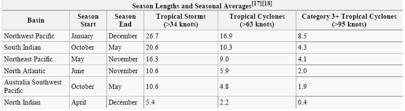
3 Tropical Cyclones Around the Globe Why none here? Why none here? Hurricane : N. Atlantic Ocean, NE Pacific Ocean, SE Pacific Ocean Typhoon : NW Pacific Ocean Severe tropical cyclone : SW Pacific Ocean, SE Indian Ocean Eevere cyclonic storm : N Indian Ocean Tropical cyclone : SW Indian Ocean
4

5 The relative sizes of the United States, Typhoon Tip and Cyclone Tracy (the largest and one of the smallest tropical cyclones recorded, respectively)

6 Global satellite image of Typhoon Tip near peak strength

7 Typhoon Tip at its record peak intensity Category 5 on October 12, 1979
 (1-minute sustained) Lowest pressure: 870 hpa (mbar) (Worldwide record low) Fatalities: 86 direct, 13 indirect Areas affected: Guam,")
8 Formed: October 4, 1979 Dissipated: October 19, 1979 Highest winds: 260 km/h (160 mph) (10-minute sustained) Typhoon Tip Storm path 305 km/h (190 mph) (1-minute sustained) Lowest pressure: 870 hpa (mbar) (Worldwide record low) Fatalities: 86 direct, 13 indirect Areas affected: Guam, Japan
 Category 3 cyclone")
9 Severe Tropical Cyclone Tracy Category 4 cyclone (Australian scale) Category 3 cyclone (SSHS)
 Fatalities: 71 Damage: $1.")
10 Formed: 21 December 1974 Dissipated: 26 December 1974 Highest winds: 205 km/h (125 mph) (1-minute sustained) 240 km/h (150 mph) (gusts) Severe Tropical Cyclone Tracy Storm path Lowest pressure: 950 hpa (mbar) Fatalities: 71 Damage: $1.1 billion (1974 USD) $5 billion (2009 USD) Areas affected: Tiwi Islands, Darwin, Northern Territory
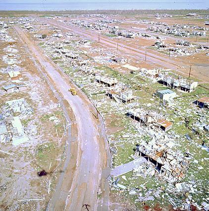
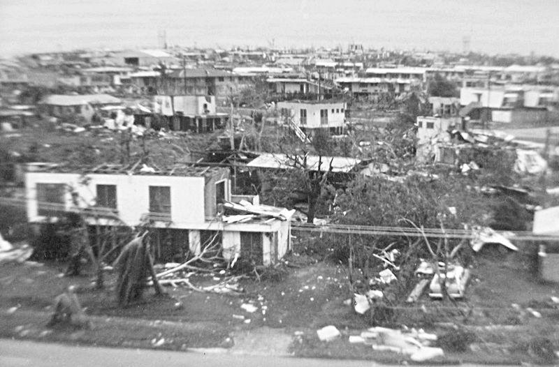
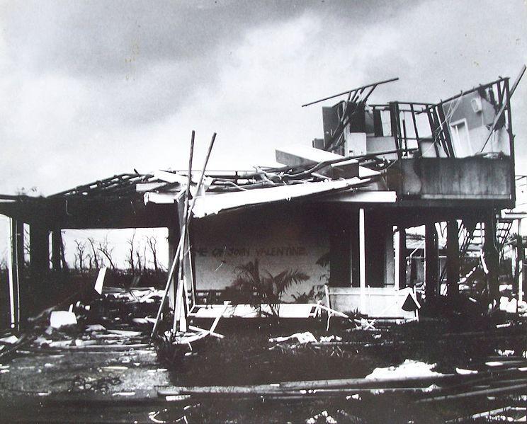
11 Devastation brought by Cyclone Tracy

12 Cyclone Catarina, a rare South Atlantic tropical cyclone, viewed from the International Space Station in March 2004

13 Catarina, a category 2 tropical cyclone, was approaching the Brazilian coastline on March 27, 2004 near peak intensity.

14 Cyclone Catarina at landfall
 $399 million (2009 USD) Areas affected: Santa Catarina and Rio Grande do")
15 Formed: March 24, 2004 Dissipated: March 28, 2004 Highest winds: 155 km/h (100 mph) (1-minute sustained) Lowest pressure: 972 hpa (mbar) (Worldwide record low) Fatalities: 3-10 direct, 13 indirect Cyclone Catarina Storm path Damage: $350 million (2004 USD) $399 million (2009 USD) Areas affected: Santa Catarina and Rio Grande do Sul, Brazil

16 Structure of a tropical cyclone A cross section diagram of a mature tropical cyclone, with arrows indicating air flow in and around the eye
17 Hurricane Structure Northern Hemisphere H L Eye wall


18 A cross section of a typical hurricane Tropical cyclones form when the energy released by the condensation of moisture in rising air causes a positive feedback loop over warm ocean waters.

19 ? A cross section of a typical hurricane

20 Katrina's Category 4 hurricane force winds were observed by NASA s QuikSCAT satellite on August 29, knot = mph = kmph
21 Temperature distribution across a hurricane Why the air temperature is much higher in the eye? (1) Latent heat is released from condensation in the formation of eye wall clouds. (2)Sinking air in the eye is compressed and warmed adiabatically.
22 Hurricane Characteristics Eye: center area, descending air, light winds, average diameter of about 25 km (15 mi). A shrinking eye indicates intensification. Eye wall: strongest winds and convergent uplifting, largest cumulonimbus clouds, heaviest precipitation as much as 2500 mm (100 inch) per day. Weak uplift or even sinking air and low precipitation regions separate individual spiral cloud bands. Lower portions: counter-clockwise rotation, pressure differences into the center of the storm are about twice as great as the average mid-latitude cyclones, plus smaller size, thus much greater pressure-gradient force resulting in strong sustained winds Upper portions: clockwise rotation, the storm are also blanketed by a cirrus cloud cap due to overall low temperatures.
23 Hurricane Characteristics Unlike mid-latitude cyclones, hurricanes are warm-core lows due to warm ocean surfaces. As air converges into the surface low pressure center, adiabatic cooling due to expansion keeps the horizontal temperature differences moderate towards the eye. Horizontal pressure gradient decreases slowly with altitude in the eye due to pressure decreases more slowly with increasing altitude in the warm core. At about 400 mb (7.5 km), pressures within the storm are approximate the same as outside pressure. From 400 mb to the tropopause, pressures within the storm exceed those outside upper portion of the storm rotates anticyclonically while lower portions rotate cyclonically.

24 Typically, eyes are easy to spot using weather radar. This radar image of Hurricane Andrew clearly shows the eye over southern Florida.

25 Radar Image of Hurricane Katrina as it approached LA coast

26 Eye Eye wall

27 A satellite photo of Typhoon Amber of the 1997 Pacific typhoon season, exhibiting an outer and inner eyewall while undergoing an eyewall replacement cycle.
, making it the strongest Atlantic hurricane in history.")
28 A picture of Hurricane Wilma's eye taken at 08:22 CDT (13:22 UTC) October 19, 2005, by the crew aboard the International Space Station. Wilma was at peak intensity at the time, with a minimum central pressure of only 882 mbar (26.06 inhg), making it the strongest Atlantic hurricane in history. Not only is this a classic example of a pinhole eye, but also of the stadium effect, where the eyewall slopes out and up.
29 Hurricane Characteristics Most powerful of all storms, energy unleashed by a single hurricane can exceed the annual electrical consumption of US & Canada. Most energy attained by hurricanes stems from latent heat release in the cloud formation process. Sustained winds > 120 kmph (74 mph). Generally of lesser intensity than tornadoes, but much larger in size and longer in life span makes hurricanes much more devastating. Average diameters are approximately 600 km (350 mi), typically ~ 1/3 of midlatitude cyclones, but no fronts. Central pressure averages about 950 mb & may be as low as 870 mb. Hurricanes occur during the times of highest SSTs. For the Northern Hemisphere, August and September are typically the most active months with highest SSTs.
30 Extratropical storms are areas of low pressure which exist at the boundary of different air masses. Almost all storms found at mid-latitudes are extratropical in nature, including classic North American nor'easters and European windstorms. The most severe of these can have a clear "eye" at the site of lowest barometric pressure, though it is usually surrounded by lower, non-convective clouds and is found near the back end of the storm. Subtropical storms are cyclones which have some extratropical characteristics and some tropical characteristics. As such, they may have an eye, but are not true tropical storms. Subtropical storms can be very hazardous, with high winds and seas, and often evolve into true tropical storms. As such, the National Hurricane Center began including subtropical storms in their naming scheme in 2002.

31 The North American blizzard of 2006, an extratropical storm, showed an eye-like structure at its peak intensity (here seen just to the east of the Delmarva Peninsula).

32 Extraterrestrial storms A hurricane-like storm on the south pole of Saturn displaying an eyewall tens of kilometers high
33 Tropical cyclogenesis is the technical term describing the development and strengthening of a tropical cyclone in the atmosphere. The mechanisms through which tropical cyclogenesis occurs are distinctly different from those through which mid-latitude cyclogenesis occurs. Tropical cyclogenesis involves the development of a warm-core cyclone, due to significant convection in a favorable atmospheric environment. An average of 86 tropical cyclones of tropical storm intensity form annually worldwide, with 47 reaching hurricane/typhoon strength, and 20 becoming intense tropical cyclones (at least Category 3 intensity on the Saffir-Simpson Hurricane Scale or SSHS).
34 Requirements for tropical cyclone formation 1. Sufficiently warm sea surface temperatures 2. Atmospheric instability 3. High humidity in the lower to middle levels of the troposphere 4. Enough Coriolis force to develop a low pressure center 5. A pre-existing low level focus or disturbance 6. Low vertical wind shear. These conditions are necessary for tropical cyclone formation, but they do not guarantee that a tropical cyclone will form.

35 SST The Tropical Setting
 spanning through at least a 50-m depth is considered the minimum to maintain the special mesocyclone that is the")
36 The Tropical Setting Depth of 26 C isotherm on October 1, 2006 Normally, an ocean temperature of 26.5 C (79.7 F) spanning through at least a 50-m depth is considered the minimum to maintain the special mesocyclone that is the tropical cyclone.
 or warmer")
37 Hurricane Katrina, August 25-27, A hurricane needs SSTs at o F (~ o C) or warmer to strengthen (NHC).

38 On rare occasions, tropical storms may form or strengthen in mid-latitudes. Hurricane Vince formed in the temperate subtropics during the 2005 Atlantic season
 Warm water Cold water Trade")
39 The Tropical Setting Subtropical High (Bermuda-Azores High) Warm water Cold water Trade wind inversion
40 Hurricane Formation Tropical disturbances: often begin in eastern ocean basins as disorganized clusters of thunderstorms with weak pressure gradients. Some form when mid-latitude troughs migrating into the tropics. Some form as part of convection associated with ITCZ. An easterly wave

41 Hurricane Formation Most tropical disturbances entering western Atlantic and becoming hurricanes originate in easterly waves, which are large undulations or ripples in normal trade wind pattern An easterly wave These waves typically stretch between km ( mi)

42 Waves in the trade winds in the Atlantic Ocean areas of converging winds that move along the same track as the prevailing wind create instabilities in the atmosphere that may lead to the formation of hurricanes.

43 The African easterly jet is a region of the lower troposphere over West Africa where the seasonal mean wind speed is maximum and easterly. The jet develops because heating of the West African land mass during the Northern Hemisphere summer creates a surface temperature and moisture gradient from the Gulf of Guinea and the Sahara, and the atmosphere responds by generating vertical wind shear to maintain thermal wind balance. During the mature phase of the West African Monsoon (August to September) maximum mean wind speeds in the jet of approximately 13 m/s are located around 4 N 5 N at a height of 4 km (or 650 mb). The jet produces synoptic scale, westward propagating disturbances known as African easterly waves ( tropical waves). A small number of mesoscale storm systems embedded in these waves develop into tropical cyclones after they move from west Africa into the tropical Atlantic.
 in the Northern hemisphere.")
44 A minimum distance of 500 km (300 miles) from the equator is normally needed for tropical cyclogenesis. The role of the Coriolis force is to provide for gradient wind balance (curved isobars). Schematic representation of flow around a low-pressure area (in this case, Hurricane Isabel) in the Northern hemisphere. The pressure gradient force is represented by blue arrows, the Coriolis acceleration (always perpendicular to the velocity) by red arrows

45 Infrared image of a powerful southern hemisphere cyclone, Monica, near peak intensity, showing clockwise rotation due to the Coriolis effect
46 Most hurricanes form between the latitudes of 5 and 20 in tropical oceans, except over the South Atlantic and Southeastern Pacific. Why?
47 Conditions Necessary for Hurricane Formation Hurricanes form only over deep warm surface ocean layers with surface temperatures in excess of o C (81-82 o F). Energy is derived from evaporation of surface water and then latent heat is released when clouds are formed. Poleward of about 20 o, water temperatures are usually below this threshold. Hurricanes are most frequent in late summer and early autumn during highest SSTs. Coriolis force is an important factor for rotation to form, as such, hurricanes do not form equatorward below 5 o latitude. An unstable atmosphere is also necessary and this typically occurs toward the central to western ocean basins as trade wind inversions and cool ocean surfaces dominate over eastern ocean basins. Strong vertical shear must be absent for hurricane formation because it disturbs supply of moisture to the hurricanes.
Chapter 24 Tropical Cyclones
 Chapter 24 Tropical Cyclones Tropical Weather Systems Tropical disturbance a cluster of thunderstorms about 250 to 600 km in diameter, originating in the tropics or sub-tropics Tropical depression a cluster
Lecture 18 Hurricanes
 Lecture 18 Hurricanes Part I Structure and Climatology What is a hurricane? What is the structure or anatomy of a hurricane? How to build a hurricane - hurricane energy Hurricane climatology - when and
Tuesday, September 13, 16
 Weather Weather State Objectives 4.c, 4.d, 4.h. Discussion What are some ways in which weather affects your everyday life? Discussion What are some ways in which weather affects your everyday life? What
(April 7, 2010, Wednesday) Tropical Storms & Hurricanes Part 2
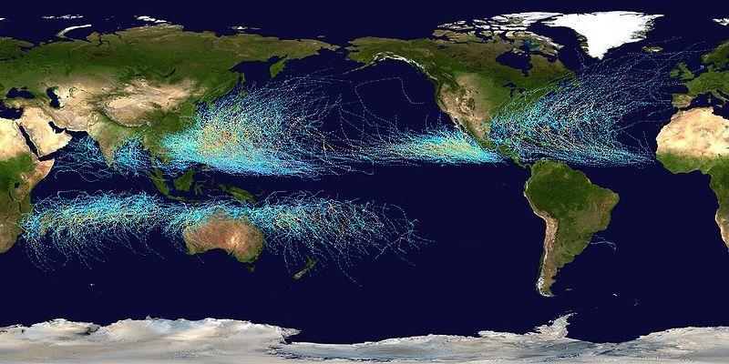
 Tropical Storms & Hurricanes Part 2") Lecture #17 (April 7, 2010, Wednesday) Tropical Storms & Hurricanes Part 2 Hurricane Katrina August 2005 All tropical cyclone tracks (1945-2006). Hurricane Formation While moving westward, tropical disturbances
Lecture #17 (April 7, 2010, Wednesday) Tropical Storms & Hurricanes Part 2 Hurricane Katrina August 2005 All tropical cyclone tracks (1945-2006). Hurricane Formation While moving westward, tropical disturbances
Tropical Cyclones. Objectives
 Tropical Cyclones FIU Undergraduate Hurricane Internship Lecture 2 8/8/2012 Objectives From this lecture you should understand: Global tracks of TCs and the seasons when they are most common General circulation
Hurricanes Part I Structure and Climatology by Professor Steven Businger. Hurricane Katrina
 Hurricanes Part I Structure and Climatology by Professor Steven Businger Hurricane Katrina Hurricanes Part I Structure and Climatology by Professor Steven Businger What is a hurricane? What is the structure
Hurricanes. April 14, 2009
 Tropical Weather & Hurricanes Chapter 15 April 14, 2009 Tropical meteorology Tropics characterized by seasonal wet and drier periods- wet when sun is nearly overhead at noon and inter-tropical convergence
- tornadoes. Further Reading: Chapter 08 of the text book. Outline. - cyclones and anti-cyclones. -tropical storms. -Storm surge
 (1 of 16) Further Reading: Chapter 08 of the text book Outline - cyclones and anti-cyclones - tornadoes -tropical storms -Storm surge (2 of 16) Introduction Previously, We talked about fronts and their
Ch. 11: Hurricanes. Be able to. Define what hurricane is. Identify the life and death of a hurricane. Identify the ways we track hurricanes.
 Ch. 11: Hurricanes Be able to Define what hurricane is. Identify the life and death of a hurricane. Identify the ways we track hurricanes. What are Hurricanes? Smaller than mid-latitude cyclones. Don t
Hurricanes. Hurricanes are large, tropical storm systems that form and develop over the warm waters near the equator.
 Hurricanes Hurricanes are large, tropical storm systems that form and develop over the warm waters near the equator. They are responsible for weather that can devastate entire communities: Heavy rain --
- tornadoes. Further Reading: Chapter 08 of the text book. Outline. -tropical storms. -Storm surge
 (1 of 12) Further Reading: Chapter 08 of the text book Outline - tornadoes -tropical storms -Storm surge (2 of 12) Introduction Previously, We talked about fronts and their relationship to air masses Also
Transient and Eddy. Transient/Eddy Flux. Flux Components. Lecture 3: Weather/Disturbance. Transient: deviations from time mean Time Mean
 Lecture 3: Weather/Disturbance Transients and Eddies Climate Roles Mid-Latitude Cyclones Tropical Hurricanes Mid-Ocean Eddies Transient and Eddy Transient: deviations from time mean Time Mean Eddy: deviations
5 Atmospheric Disturbances 7 1.Cyclones- tropical and temperate and associated weather conditions. 2.Anticyclones and associated weather conditions.
 5 Atmospheric Disturbances 7 1.Cyclones- tropical and temperate and associated weather conditions. 2.Anticyclones and associated weather conditions. atmospheric disturbances (weather systems) that are
Chapter 24. Tropical Cyclones. Tropical Cyclone Classification 4/19/17
 Chapter 24 Tropical Cyclones Tropical Cyclones Most destructive storms on the planet Originate over tropical waters, but their paths often take them over land and into midlatitudes Names Hurricane (Atlantic
Divergence, Spin, and Tilt. Convergence and Divergence. Midlatitude Cyclones. Large-Scale Setting
 Midlatitude Cyclones Equator-to-pole temperature gradient tilts pressure surfaces and produces westerly jets in midlatitudes Waves in the jet induce divergence and convergence aloft, leading to surface
Lecture #18 (April 12, 2010, Monday) Tropical Storms & Hurricanes Part 3. Hurricane Floyd September 15, 1999
 Tropical Storms & Hurricanes Part 3. Hurricane Floyd September 15, 1999") Lecture #18 (April 12, 2010, Monday) Tropical Storms & Hurricanes Part 3 Hurricane Floyd September 15, 1999 Tropical Cyclone Names Names are given to distinguish storms and for ease of communication. Names
Lecture #18 (April 12, 2010, Monday) Tropical Storms & Hurricanes Part 3 Hurricane Floyd September 15, 1999 Tropical Cyclone Names Names are given to distinguish storms and for ease of communication. Names
True or false: The atmosphere is always in hydrostatic balance. A. True B. False
 Clicker Questions and Clicker Quizzes Clicker Questions Chapter 7 Of the four forces that affect the motion of air in our atmosphere, which is to thank for opposing the vertical pressure gradient force
Foundations of Earth Science, 6e Lutgens, Tarbuck, & Tasa
 Foundations of Earth Science, 6e Lutgens, Tarbuck, & Tasa Weather Patterns and Severe Weather Foundations, 6e - Chapter 14 Stan Hatfield Southwestern Illinois College Air masses Characteristics Large body
Introduction to Meteorology & Climate. Climate & Earth System Science. Atmosphere Ocean Interactions. A: Structure of the Ocean.
 Climate & Earth System Science Introduction to Meteorology & Climate MAPH 10050 Peter Lynch Peter Lynch Meteorology & Climate Centre School of Mathematical Sciences University College Dublin Meteorology
Atmospheric Circulation
 Atmospheric Circulation Introductory Oceanography Instructor: Ray Rector Atmospheric Circulation Key Topics Composition and Structure Solar Heating and Convection The Coriolis Effect Global Wind Patterns
Hurricane: an organized tropical storm system featuring vigorous convection and sustained winds in excess of 64 knots (74 mph)
") Hurricane: an organized tropical storm system featuring vigorous convection and sustained winds in excess of 64 knots (74 mph) The storms have different names, depending on where they form: Western Hemisphere:
Hurricane: an organized tropical storm system featuring vigorous convection and sustained winds in excess of 64 knots (74 mph) The storms have different names, depending on where they form: Western Hemisphere:
Section 13-1: Thunderstorms
 Section 13-1: Thunderstorms Chapter 13 Main Idea: The intensity and duration of thunderstorms depend on the local conditions that create them. Air-mass thunderstorm Mountain thunderstorm Sea-breeze thunderstorm
Inner core dynamics: Eyewall Replacement and hot towers
 Inner core dynamics: Eyewall Replacement and hot towers FIU Undergraduate Hurricane Internship Lecture 4 8/13/2012 Why inner core dynamics is important? Current TC intensity and structure forecasts contain
Unit 5 Part 2 Test PPT
 Unit 5 Part 2 Test PPT Standard 1: Air Masses Air Mass An air mass is an immense body of air that is characterized by similar temperatures and amounts of moisture at any given altitude When an air mass
Air Masses, Weather Systems and Hurricanes
 The Earth System - Atmosphere IV Air Masses, Weather Systems and Hurricanes Air mass a body of air which takes on physical characteristics which distinguish it from other air. Classified on the basis of
Module 11: Meteorology Topic 6 Content: Severe Weather Notes
 Severe weather can pose a risk to you and your property. Meteorologists monitor extreme weather to inform the public about dangerous atmospheric conditions. Thunderstorms, hurricanes, and tornadoes are
CHAPTER 12 TROPICAL WEATHER SYSTEMS MULTIPLE CHOICE QUESTIONS
 CHAPTER 12 TROPICAL WEATHER SYSTEMS MULTIPLE CHOICE QUESTIONS 1. A hurricane differs from an extra-tropical cyclone in that a hurricane a. has no fronts. b. develops within a uniform warm and humid air
b) occurs before the anvil shape at the top of the cloud has formed. c) is marked by an absence of significant downdrafts.
 occurs before the anvil shape at the top of the cloud has formed. c) is marked by an absence of significant downdrafts.") Thunderstorms Question 1 The only requirement for a thunderstorm is: a) sinking air. b) upper level convergence. c) still air. d) rising air. Question 2 The mature stage of air-mass thunderstorms: a) is
Thunderstorms Question 1 The only requirement for a thunderstorm is: a) sinking air. b) upper level convergence. c) still air. d) rising air. Question 2 The mature stage of air-mass thunderstorms: a) is
Wind: Global Systems Chapter 10
 Wind: Global Systems Chapter 10 General Circulation of the Atmosphere General circulation of the atmosphere describes average wind patterns and is useful for understanding climate Over the earth, incoming
11/19/14. Chapter 11: Hurricanes. The Atmosphere: An Introduction to Meteorology, 12 th. Lutgens Tarbuck
 Chapter 11: Hurricanes The Atmosphere: An Introduction to Meteorology, 12 th Lutgens Tarbuck Lectures by: Heather Gallacher, Cleveland State University! Hurricanes: " Hurricanes are intense centers of
Tropical Waves. John Cangialosi and Lixion Avila National Hurricane Center. WMO Region IV Tropical Cyclone Workshop
 Tropical Waves John Cangialosi and Lixion Avila National Hurricane Center WMO Region IV Tropical Cyclone Workshop Outline Basic definition Schematic diagrams/interactions Operational products/forecasts
Science 1206 Chapter 1 - Inquiring about Weather
 Science 1206 Chapter 1 - Inquiring about Weather 1.1 - The Atmosphere: Energy Transfer and Properties (pp. 10-25) Weather and the Atmosphere weather the physical conditions of the atmosphere at a specific
The Planetary Circulation System
 12 The Planetary Circulation System Learning Goals After studying this chapter, students should be able to: 1. describe and account for the global patterns of pressure, wind patterns and ocean currents
General Atmospheric Circulation
 General Atmospheric Circulation Take away Concepts and Ideas Global circulation: The mean meridional (N-S) circulation Trade winds and westerlies The Jet Stream Earth s climate zones Monsoonal climate
LECTURE #17: Severe Weather: Introduction to Hurricanes
 GEOL 0820 Ramsey Natural Disasters Spring, 2018 LECTURE #17: Severe Weather: Introduction to Hurricanes Date: 15 March 2018 I. Hurricane Overview hurricanes o what they are? o how they form? storm stages:
Ch. 3: Weather Patterns
 Ch. 3: Weather Patterns Sect. 1: Air Mass & Fronts Sect. 2: Storms Sect. 3: Predicting the Weather Sect. 4: Weather forecasters use advanced technologies Ch. 3 Weather Fronts and Storms Objective(s) 7.E.1.3
Tropical Cyclones: When Nature Attacks!! AOSC 200 Tim Canty. Tropical Cyclone: African Easterly Jet
 Tropical Cyclones: When Nature Attacks!! AOSC 200 Tim Canty Class Web Site: http://www.atmos.umd.edu/~tcanty/aosc200 Topics for today: Really powerful low pressure systems Lecture 25 Nov 27 2018 1 Tropical
ESCI 241 Meteorology Lesson 19 Tropical Cyclones Dr. DeCaria
 ESCI 241 Meteorology Lesson 19 Tropical Cyclones Dr. DeCaria READING: Chapter 16 GENERAL A tropical cyclone is a large, low-pressure system that forms over the tropical oceans. Tropical cyclones are classified
Severe Weather: Tornadoes and Hurricanes
 Severe Weather: Tornadoes and Hurricanes Tornadoes Grab Toto!! TORNADOES Are a low pressure storm that usually forms over land in an average year, 800 tornadoes are reported in the U.S. a tornado is defined
CHAPTER 9 ATMOSPHERE S PLANETARY CIRCULATION MULTIPLE CHOICE QUESTIONS
 CHAPTER 9 ATMOSPHERE S PLANETARY CIRCULATION MULTIPLE CHOICE QUESTIONS 1. Viewed from above in the Northern Hemisphere, surface winds about a subtropical high blow a. clockwise and inward. b. counterclockwise.
Huracan: evil Taino & Mayan god of winds & destruction
 Huracan: evil Taino & Mayan god of winds & destruction Profile of a Tropical Cyclone! Hurricane = typhoon = cyclone! All different words for the same thing Eye: clear area in the center Eyewall: clouds
Hurricane Recipe. Hurricanes
 Hurricanes A hurricane is a powerful, rotating storm that forms over warm oceans near the Equator. Hurricanes have strong, rotating winds (at least 74 miles per hour), a huge amount of rain, low air pressure,
Go With the Flow From High to Low Investigating Isobars
 Go With the Flow From High to Low Investigating Isobars Science 10 Mrs. Purba Air Masses The air over a warm surface can be heated, causing it to rise above more dense air. The result is the formation
ATMO 436a. The General Circulation. Redacted version from my NATS lectures because Wallace and Hobbs virtually ignores it
 ATMO 436a The General Circulation Redacted version from my NATS lectures because Wallace and Hobbs virtually ignores it Scales of Atmospheric Motion vs. Lifespan The general circulation Atmospheric oscillations
2) What general circulation wind belt is the place of origin for hurricanes? A) westerlies B) trade winds C) doldrums D) horse latitudes
 What general circulation wind belt is the place of origin for hurricanes? A) westerlies B) trade winds C) doldrums D) horse latitudes") Meteo 1010 Homework 6 1) What is the difference between a typhoon and a hurricane? A) A hurricane is a true tropical cyclone, but a typhoon is not. B) A hurricane is stronger than a typhoon. C) They represent
Meteo 1010 Homework 6 1) What is the difference between a typhoon and a hurricane? A) A hurricane is a true tropical cyclone, but a typhoon is not. B) A hurricane is stronger than a typhoon. C) They represent
20.1 Air Masses. Weather Patterns and Severe Storms. Four Types of Source Regions. Weather in North America Fronts
 20.1 Air Masses Weather Patterns and Severe Storms Chapter 20 A huge body of air that has a uniform temperature and humidity. They move slowly, and take on the properties of their source regions. Four
Global Wind Patterns
 Name: Earth Science: Date: Period: Global Wind Patterns 1. Which factor causes global wind patterns? a. changes in the distance between Earth and the Moon b. unequal heating of Earth s surface by the Sun
Winds and Global Circulation
 Winds and Global Circulation Atmospheric Pressure Winds Global Wind and Pressure Patterns Oceans and Ocean Currents El Nino How is Energy Transported to its escape zones? Both atmospheric and ocean transport
Chapter 21. Weather Patterns and Severe Storms
 Chapter 21 Weather Patterns and Severe Storms 20.1 Air Masses Air Masses and Weather Air Masses An air mass is an immense body of air that is characterized by similar temperatures and amounts of moisture
3. As warm, moist air moves into a region, barometric pressure readings in the region will generally 1. decrease 2. increase 3.
 Teacher: Mr. Prizzi Castle Learning Review 1 1. Which process most directly results in cloud formation? 1. condensation 3. precipitation 2. transpiration 4. radiation 2. An air mass originating over north
Hurricanes and Tropical Weather Systems:
 Hurricanes and Tropical Weather Systems: An influence on weather in parts of the USA Meteorology 411 Iowa State University Week 2 Bill Gallus Classification/Terminology Tropical Disturbance enhanced convection
General Circulation. Nili Harnik DEES, Lamont-Doherty Earth Observatory
 General Circulation Nili Harnik DEES, Lamont-Doherty Earth Observatory nili@ldeo.columbia.edu Latitudinal Radiation Imbalance The annual mean, averaged around latitude circles, of the balance between the
Weather Patterns and Severe Storms
 Weather Patterns and Severe Storms 20.1 Air Masses Air Masses and Weather Air Masses An air mass is an immense body of air that is characterized by similar temperatures and amounts of moisture at any given
HURRICANES. Source:
 HURRICANES Source: http://www.dc.peachnet.edu/~pgore/students/w97/matheson/hpage.htm What is a hurricane? Violent cyclonic storm that develops in the tropical region Wind speeds are > 74 mph Source: http://www.google.com/imgres?hl=en&sa=x&biw=1920&bih=955&tbm=
Use the terms from the following list to complete the sentences below. Each term may be used only once.
 Skills Worksheet Directed Reading Section: Air Masses Use the terms from the following list to complete the sentences below. Each term may be used only once. high pressure poles low pressure equator wind
4/29/2011. Mid-latitude cyclones form along a
 Chapter 10: Cyclones: East of the Rocky Mountain Extratropical Cyclones Environment prior to the development of the Cyclone Initial Development of the Extratropical Cyclone Early Weather Along the Fronts
ATSC 2000 Final Fall 2005
 ATSC 2000 Final Fall 2005 true/false /25 multiple choice /25 short answer /23 essay /10 total /83 or % True/False Indicate whether the sentence or statement is true or false. (25 questions 1% each) 1.
Weather Systems. Section
 Section 1 12.2 Objectives Compare and contrast the three major wind systems. Identify four types of fronts. Distinguish between highand low-pressure systems. Review Vocabulary convection: the transfer
PRMS WHITE PAPER 2014 NORTH ATLANTIC HURRICANE SEASON OUTLOOK. June RMS Event Response
 PRMS WHITE PAPER 2014 NORTH ATLANTIC HURRICANE SEASON OUTLOOK June 2014 - RMS Event Response 2014 SEASON OUTLOOK The 2013 North Atlantic hurricane season saw the fewest hurricanes in the Atlantic Basin
DEPARTMENT OF EARTH & CLIMATE SCIENCES NAME SAN FRANCISCO STATE UNIVERSITY Fall ERTH FINAL EXAMINATION KEY 200 pts
 DEPARTMENT OF EARTH & CLIMATE SCIENCES NAME SAN FRANCISCO STATE UNIVERSITY Fall 2016 Part 1. Weather Map Interpretation ERTH 365.02 FINAL EXAMINATION KEY 200 pts Questions 1 through 9 refer to Figure 1,
Weather is the of the Earth s atmosphere at a place and time. It is the movement of through the atmosphere o Energy comes from the
 Weather Notes Weather Weather is the of the Earth s atmosphere at a place and time It is the movement of through the atmosphere o Energy comes from the The sun is the force that weather The sun s energy
Global Weather Trade Winds etc.notebook February 17, 2017
 Global Weather 1 north pole northern hemisphere equator southern hemisphere south pole 2 We have seasons because of the Earth's tilt The seasons are opposite in the northern and southern hemispheres winter
Weather Notes. Chapter 16, 17, & 18
 Weather Notes Chapter 16, 17, & 18 Weather Weather is the condition of the Earth s atmosphere at a particular place and time Weather It is the movement of energy through the atmosphere Energy comes from
Transient/Eddy Flux. Transient and Eddy. Flux Components. Lecture 7: Disturbance (Outline) Why transients/eddies matter to zonal and time means?
 Why transients/eddies matter to zonal and time means?") Lecture 7: Disturbance (Outline) Transients and Eddies Climate Roles Mid-Latitude Cyclones Tropical Hurricanes Mid-Ocean Eddies (From Weather & Climate) Flux Components (1) (2) (3) Three components contribute
Lecture 7: Disturbance (Outline) Transients and Eddies Climate Roles Mid-Latitude Cyclones Tropical Hurricanes Mid-Ocean Eddies (From Weather & Climate) Flux Components (1) (2) (3) Three components contribute
1. Sea Surface Temperatures (SSTs) > 27 and extending to some depth.
 > 27 and extending to some depth.") Formation Factors for Hurricanes 1. Sea Surface Temperatures (SSTs) > 27 and extending to some depth. 2. Location >5 away from the equator (usually 10 ). Coriolis force is necessary for rotation. 3. High
Formation Factors for Hurricanes 1. Sea Surface Temperatures (SSTs) > 27 and extending to some depth. 2. Location >5 away from the equator (usually 10 ). Coriolis force is necessary for rotation. 3. High
Ch. 3: Weather Patterns. Sect. 1: Air Mass & Fronts Sect. 2: Storms Sect. 3: Predicting the Weather
 Ch. 3: Weather Patterns Sect. 1: Air Mass & Fronts Sect. 2: Storms Sect. 3: Predicting the Weather Sect. 1: Air Masses & Fronts An air mass is a huge body of air that has similar temperature, humidity,
1. Which weather map symbol is associated with extremely low air pressure? A) B) C) D) 2. The diagram below represents a weather instrument.
 B) C) D) 2. The diagram below represents a weather instrument.") 1. Which weather map symbol is associated with extremely low air pressure? 2. The diagram below represents a weather instrument. Which weather variable was this instrument designed to measure? A) air pressure
1. Which weather map symbol is associated with extremely low air pressure? 2. The diagram below represents a weather instrument. Which weather variable was this instrument designed to measure? A) air pressure
Why There Is Weather?
 Lecture 6: Weather, Music Of Our Sphere Weather and Climate WEATHER The daily fluctuations in atmospheric conditions. The atmosphere on its own can produce weather. (From Understanding Weather & Climate)
Science Olympiad Meteorology Quiz #2 Page 1 of 8
 1) The prevailing general direction of the jet stream is from west to east in the northern hemisphere: 2) Advection is the vertical movement of an air mass from one location to another: 3) Thunderstorms
Characteristics of extreme convection over equatorial America and Africa
 Characteristics of extreme convection over equatorial America and Africa Manuel D. Zuluaga, K. Rasmussen and R. A. Houze Jr. Atmospheric & Climate Dynamics Seminar Department of Atmospheric Sciences, University
Chapter 18/19. Ch 18
 Chapter 18/19 Ch 18 Pressure Force of the weight of the air above At sea level: 14.7 lbs/in2 Decreases with altitude Inches of mercury (29.92 @ sea level) Barometer - instrument used to measure air pressure
Air Masses, Fronts, Storm Systems, and the Jet Stream
 Air Masses, Fronts, Storm Systems, and the Jet Stream Air Masses When a large bubble of air remains over a specific area of Earth long enough to take on the temperature and humidity characteristics of
An upper to mid level circulation (Low) in the NW Caribbean is
 in the NW Caribbean is") WEEKLY WEATHER OUTLOOK BELIZE, CENTRAL AMERICA PERIOD: Monday-Monday, Oct. 1 October 8, 2012 DATE ISSUED: Monday, Oct 1, 2012 6:00 am RFrutos EcoSolutions & Services SYNOPSIS: An upper to mid level circulation
WEEKLY WEATHER OUTLOOK BELIZE, CENTRAL AMERICA PERIOD: Monday-Monday, Oct. 1 October 8, 2012 DATE ISSUED: Monday, Oct 1, 2012 6:00 am RFrutos EcoSolutions & Services SYNOPSIS: An upper to mid level circulation
DEPARTMENT OF EARTH & CLIMATE SCIENCES SAN FRANCISCO STATE UNIVERSITY EARTH 365. Fall 2018 Test #2. November :00pm 7:15pm
 1 DEPARTMENT OF EARTH & CLIMATE SCIENCES SAN FRANCISCO STATE UNIVERSITY EARTH 365 Fall 2018 Test #2 November 6 2018 6:00pm 7:15pm 200 points (4 points each answer) Answer on the answer sheet provided.
CHAPTER 2 - ATMOSPHERIC CIRCULATION & AIR/SEA INTERACTION
 Chapter 2 - pg. 1 CHAPTER 2 - ATMOSPHERIC CIRCULATION & AIR/SEA INTERACTION The atmosphere is driven by the variations of solar heating with latitude. The heat is transferred to the air by direct absorption
Test Form: A Key Final Exam: Spring 2011
 Test Form: A Key Final Exam: Spring 2011 Instructions: Write your name (last name and first name) on your bubble sheet. Write your student identification number on the bubble sheet, and carefully and completely
Ocean in Motion 7: El Nino and Hurricanes!
 Ocean in Motion 7: El Nino and Hurricanes! A. Overview 1. Ocean in Motion -- El Nino and hurricanes We will look at the ocean-atmosphere interactions that cause El Nino and hurricanes. Using vocabulary
Analysis of Fall Transition Season (Sept-Early Dec) Why has the weather been so violent?
 Why has the weather been so violent?") WEATHER TOPICS Analysis of Fall Transition Season (Sept-Early Dec) 2009 Why has the weather been so violent? As can be seen by the following forecast map, the Fall Transition and early Winter Season of
WEATHER TOPICS Analysis of Fall Transition Season (Sept-Early Dec) 2009 Why has the weather been so violent? As can be seen by the following forecast map, the Fall Transition and early Winter Season of
LECTURE #18: Hurricane Damage, Monitoring & Case Study
 GEOL 0820 Ramsey Natural Disasters Spring, 2018 LECTURE #18: Hurricane Damage, Monitoring & Case Study Date: 27 March 2018 I. Exam II grades now posted online o high: 98, low: 46, average: 80 (~3 points
IV. Atmospheric Science Section
 EAPS 100 Planet Earth Lecture Topics Brief Outlines IV. Atmospheric Science Section 1. Introduction, Composition and Structure of the Atmosphere Learning objectives: Understand the basic characteristics
b. The boundary between two different air masses is called a.
 NAME Earth Science Weather WebQuest Part 1. Air Masses 1. Find out what an air mass is. http://okfirst.mesonet.org/train/meteorology/airmasses.html a. What is an air mass? An air mass is b. The boundary
3 Severe Weather. Critical Thinking
 CHAPTER 2 3 Severe Weather SECTION Understanding Weather BEFORE YOU READ After you read this section, you should be able to answer these questions: What are some types of severe weather? How can you stay
FORMATION OF AIR MASSES
 Chapter 24: Weather (air mass, fronts, Weather instruments, and forecasting the weather) Name: Period: Due Date: Air Mass Use the terms from the following list to complete the sentences below. Each term
A Tropical Cyclone with a Very Large Eye
 JANUARY 1999 PICTURES OF THE MONTH 137 A Tropical Cyclone with a Very Large Eye MARK A. LANDER University of Guam, Mangilao, Guam 9 September 1997 and 2 March 1998 1. Introduction The well-defined eye
Hurricanes are intense vortical (rotational) storms that develop over the tropical oceans in regions of very warm surface water.
 storms that develop over the tropical oceans in regions of very warm surface water.") Hurricanes: Observations and Dynamics Houze Section 10.1. Holton Section 9.7. Emanuel, K. A., 1988: Toward a general theory of hurricanes. American Scientist, 76, 371-379 (web link). http://ww2010.atmos.uiuc.edu/(gh)/guides/mtr/hurr/home.rxml
Hurricanes: Observations and Dynamics Houze Section 10.1. Holton Section 9.7. Emanuel, K. A., 1988: Toward a general theory of hurricanes. American Scientist, 76, 371-379 (web link). http://ww2010.atmos.uiuc.edu/(gh)/guides/mtr/hurr/home.rxml
DEPARTMENT OF GEOSCIENCES SAN FRANCISCO STATE UNIVERSITY. Metr Fall 2012 Test #1 200 pts. Part I. Surface Chart Interpretation.
 DEPARTMENT OF GEOSCIENCES SAN FRANCISCO STATE UNIVERSITY NAME Metr 356.01 Fall 2012 Test #1 200 pts Part I. Surface Chart Interpretation. Figure 1. Surface Chart for 1500Z 7 September 2007 1 1. Pressure
CHAPTER 6 Air-Sea Interaction Pearson Education, Inc.
 CHAPTER 6 Air-Sea Interaction Chapter Overview The atmosphere and the ocean are one independent system. Earth has seasons because of the tilt on its axis. There are three major wind belts in each hemisphere.
The most abundant gas in the atmosphere by volume is. This gas comprises 78% of the Earth atmosphere by volume.
 The most abundant gas in the atmosphere by volume is. This gas comprises 78% of the Earth atmosphere by volume. A. Oxygen B. Water Vapor C. Carbon Dioxide D. Nitrogen An isobar is a line of constant. A.
Lab 20. Predicting Hurricane Strength: How Can Someone Predict Changes in Hurricane Wind Speed Over Time?
 Predicting Hurricane Strength How Can Someone Predict Changes in Hurricane Wind Speed Over Time? Lab Handout Lab 20. Predicting Hurricane Strength: How Can Someone Predict Changes in Hurricane Wind Speed
Chapter 9 External Energy Fuels Weather and Climate
 Natural Disasters Tenth Edition Chapter 9 External Energy Fuels Weather and Climate Copyright The McGraw-Hill Companies, Inc. Permission required for reproduction or display. 9-1 Weather Versus Climate
WEATHER. Review Note Cards
 WEATHER Review Note Cards Thermometer Weather instrument that measures air temperature Units include F, C, and K ESRT 13 Sling Psychrometer Weather instrument that measures relative humidity and dewpoint
Atmospheric Moisture, Precipitation, and Weather Systems
 Atmospheric Moisture, Precipitation, and Weather Systems 6 Chapter Overview The atmosphere is a complex system, sometimes described as chaotic in nature. In this chapter we examine one of the principal
Vertical Structure of Atmosphere
 ATMOS 3110 Introduction to Atmospheric Sciences Distribution of atmospheric mass and gaseous constituents Because of the earth s gravitational field, the atmosphere exerts a downward forces on the earth
Lecture Outlines PowerPoint. Chapter 19 Earth Science 11e Tarbuck/Lutgens
 Lecture Outlines PowerPoint Chapter 19 Earth Science 11e Tarbuck/Lutgens 2006 Pearson Prentice Hall This work is protected by United States copyright laws and is provided solely for the use of instructors
ESCI 344 Tropical Meteorology Lesson 7 Temperature, Clouds, and Rain
 ESCI 344 Tropical Meteorology Lesson 7 Temperature, Clouds, and Rain References: Forecaster s Guide to Tropical Meteorology (updated), Ramage Tropical Climatology, McGregor and Nieuwolt Climate and Weather
Earth Science, 11e. Weather Patterns and Severe Storms Chapter 19. Air masses. A cold Canadian air mass Figure Air masses. Air masses 9/5/2012
 2006 Pearson Prentice Hall Lecture Outlines PowerPoint Chapter 19 Earth Science 11e Tarbuck/Lutgens This work is protected by United States copyright laws and is provided solely for the use of instructors
Meteorology. I. The Atmosphere - the thin envelope of gas that surrounds the earth.
 Meteorology I. The Atmosphere - the thin envelope of gas that surrounds the earth. A. Atmospheric Structure - the atmosphere is divided into five distinct layers that are based on their unique characteristics.
Page 1. Name:
 Name: 1) As the difference between the dewpoint temperature and the air temperature decreases, the probability of precipitation increases remains the same decreases 2) Which statement best explains why
Hadley Circulation in Action. MET 200 Lecture 12! Global Winds: The General Circulation of the Atmosphere. Scales of Motion
 Hadley Circulation in Action MET 200 Lecture 12! Global Winds: The General Circulation of the Atmosphere 1 2 Previous Lecture Local Winds cales of Motion Eddies ea Breeze Mountain-Valley Circulations Chinook
DEPARTMENT OF EARTH & CLIMATE SCIENCES SAN FRANCISCO STATE UNIVERSITY. Metr Fall 2014 Test #1 September 30, 2014
 DEPARTMENT OF EARTH & CLIMATE SCIENCES SAN FRANCISCO STATE UNIVERSITY NAME Metr 302.02 Fall 2014 Test #1 September 30, 2014 200 pts (4 pts each answer) Part I. Surface Chart Interpretation. Questions 1