Tracing and tracking sediment sources in river catchments
|
|
|
- Ethelbert Higgins
- 5 years ago
- Views:
Transcription


1 Insert image here Insert image here Tracing and tracking sediment sources in river catchments Adrian Collins and Yusheng Zhang Delivering the WFD 1
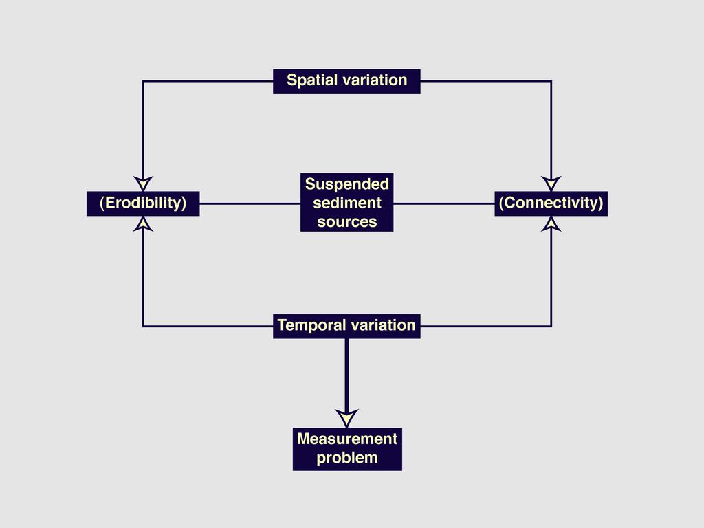
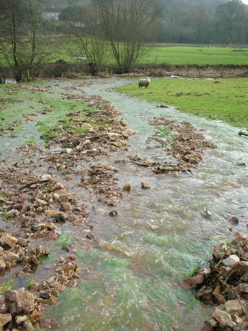
2 The sediment problem information on sediment SOURCES is urgently required to target mitigation options information on the EFFICACY of mitigation options is urgently required Understanding sediment sources 2
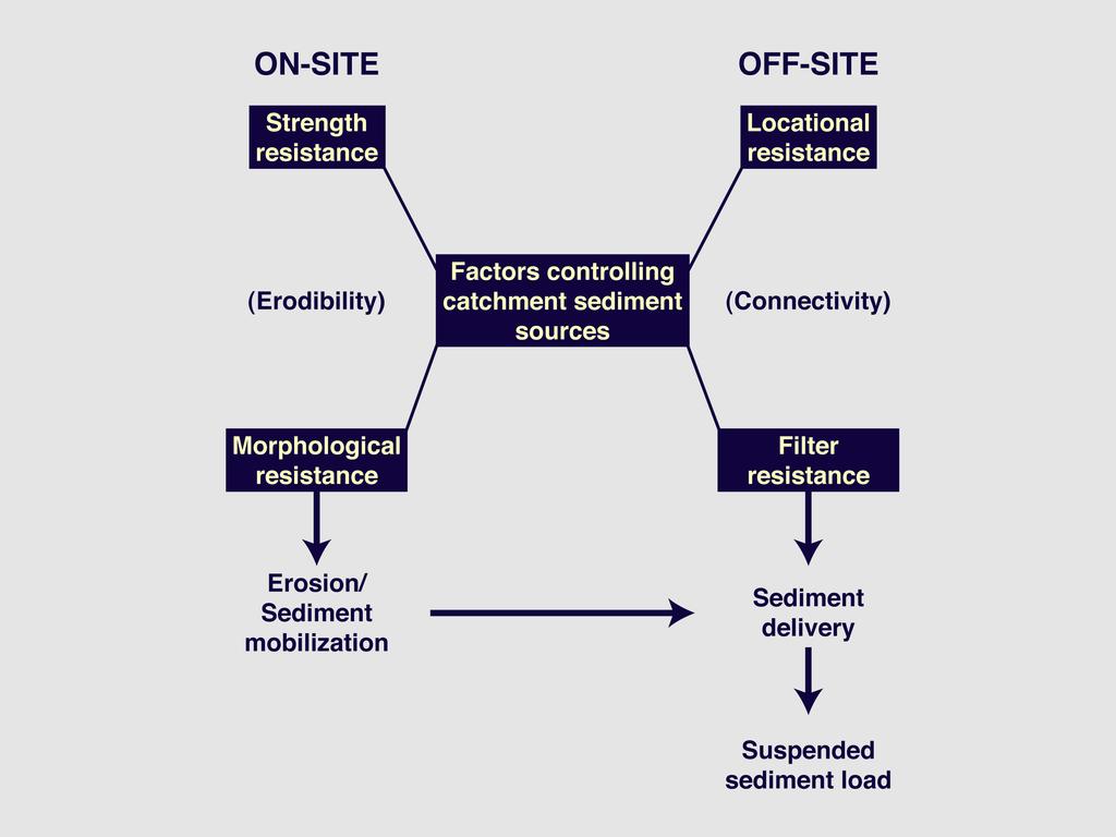
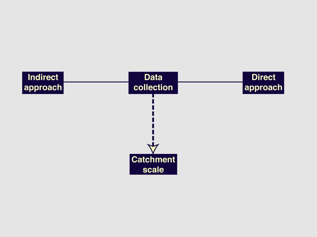
3 The measurement/monitoring problem 3
4 4

5 The measurement/monitoring problem INDIRECT APPROACH - erosion mapping - surveying - profilometers - erosion pins/peep - GPS - photogrammetry - erosion plots - bounded / unbounded The measurement/monitoring problem DIRECT APPROACH - SEDIMENT TRACING 5

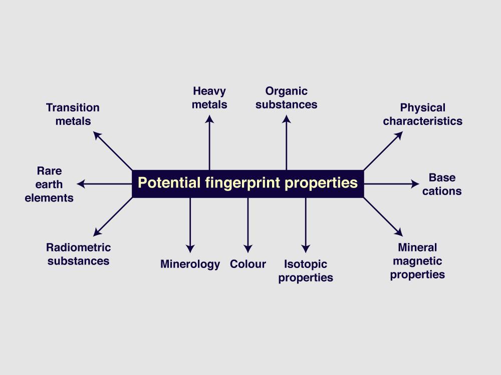
6 Sediment fingerprinting Sediment source classification 6


7 Spatial sources geological zones Spatial sources tributary subcatchments River monitoring sites 7


8 Spatial sediment sourcing dual-pronged sediment sampling instantaneous bed sediment remobilisation time-integrated sampling using retrievable baskets Generic sediment source types pasture topsoils cultivated topsoils damaged road verges channel banks/subsurface sources STWs 8
9 9
10 Sediment source discrimination Sediment fingerprints high Source 1 single component Source 2 Concentration Source 3 Sediment low 10
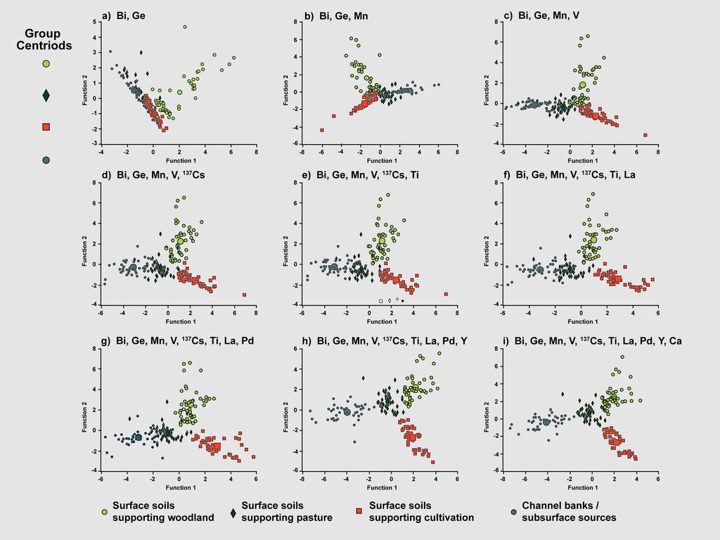
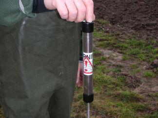
11 Sediment fingerprints composite 11
12 Sediment source apportionment Revised numerical mass balance modelling particle size selectivity organic matter selectivity within-source variation in tracer properties tracer discriminatory power prior information on bank erosion inputs uncertainty in characterising input property values for sources and sediment combination of local and global optimisation tools 12
13 Revised uncertainty analysis random sampling with conventional statistics random sampling with robust statistics LHS sampling with conventional statistics LHS sampling with robust statistics pdfs for sources and sediment Histogram for Random Numbers
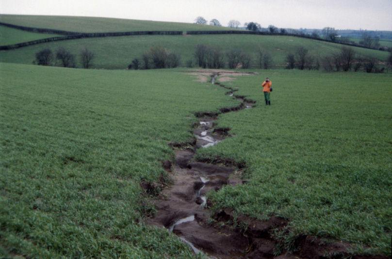
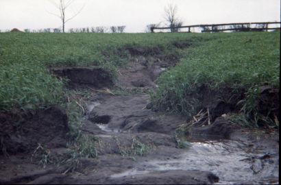
14 Local and global optimisation Date 29/10/02-19/11/02 19/11/02-17/12/02 17/12/02-7/01/03 7/01/03-4/02/03 4/02/03-11/03/03 11/03/03-3/07/03 Random start 5 out of out of out of out of out of out of 5000 Local start 12 out of out of out of out of out of out of

15 Local and global optimisation Sub-catchment Upper Axe Temple Brook River Synderford Blackwater River Kit Brook River Yarty Local start Select GA Y Y Y N Y Y Improving the resolution of sediment source information work to date provides generic information e.g. % input from grassland need to improve the resolution to assist mitigation targeting further 15


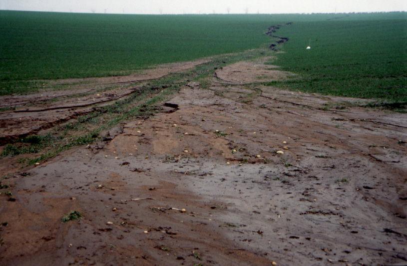
16 Higher resolution arable sources wheelings interwheelings cultivated fields pasture fields channel banks downstream suspended sediment load Higher resolution grassland sources poached gateways poached cattle tracks cultivated fields pasture fields channel banks downstream suspended sediment load wider poaching /pugging 16


17 Higher resolution bank sources poached banks natural fluvial scour cultivated fields pasture fields channel banks downstream suspended sediment load Coupling to CSF capital grant options 17


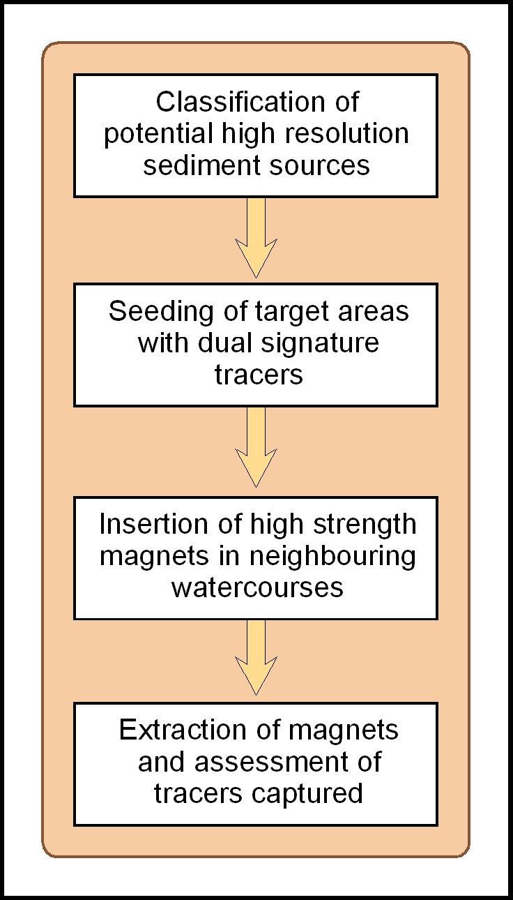
18 Sediment tracking labelling of target areas using synthetic tracers Sediment tracking 11,000 gauss magnets inserted in watercourses 18


19 Sediment tracking 19
20 20

21 Biglands Bog: high resolution sources configurations of high risk in grassland wider poached areas poached cattle tracks poached gateways The approach conventional source fingerprinting particle tracking particle tracking 21
22 Biglands Bog: high resolution sediment sources % c o n trib u tio n grassland = ~75% total load 0 wider areas of hoofing damage poached cattle tracks poached gateways High resolution grassland sediment source High resolution arable and bank sources (River Glaven, Norfolk) arable = ~30% total load banks = ~35% total load % contribution wheelings inter-wheelings poached river banks natural river bank fluvial scour High resolution sediment source 22
23 Assessing the efficacy of sediment mitigation options Mitigation method effectiveness ID Mitigation Method Arable Clay Loam Sandy Loam Grass Clay Loam Sandy Loam 1 Convert arable land to extensive grassland Establish cover crops in the autumn Cultivate land for crop establishment in spring, not autumn Adopt minimal cultivation systems Cultivate compacted tillage soils Cultivate and drill across the slope Leave autumn seedbeds rough Avoid tramlines over winter Establish in-field grass buffer strips Loosen compacted soil layers in grassland fields Maintain and enhance soil organic matter levels Allow field drainage systems to deteriorate Reduce overall stocking rates on livestock farms Reduce the length of the grazing day or grazing season Reduce field stocking rates when soils are wet Move feed and water troughs at regular intervals Fence off rivers and streams from livestock Construct bridges for livestock crossing rivers and streams Re-site gateways away from high-risk areas Establish new hedges Establish riparian buffer strips Establish and maintain artificial (constructed) wetlands

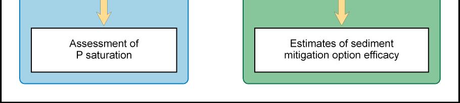
24 Efficacy of river bank fencing 24


25 Insertion of basket samplers Insertion of basket samplers use of coloured string to mark inserted basket 25


26 Retrieval of basket samplers use of outer sleeve to prevent the winnowing of fine interstitial sediment during basket removal from the river bed 26
27 27


28 Efficacy of river bank fencing success undermined by insertion of drinking bays Efficacy of river bank fencing success undermined by poor maintenance 28


29 Insert image here The Demonstration Test Catchment project Insert image here The project components 29


30 Experimental design Organic and inorganic sources in a single framework source apportionment of organic sources using fluorescenceexcitation-emissionspectra (EEMS) and PARAFAC analysis NIR reflectance TC, TN, TOC analysis bulk stable isotopes for 15 N and 13 C potential organic sediment sources agriculture slurries, manures damaged road verges (decaying vegetation) banks (decaying riparian and instream vegetation point sources (STWs / septic tanks 30


31 Mitigation options stream bank fencing improved maize management improved slurry storage improved cultivation timings feeder ring management Advantages of the developing framework applicable at a range of scales links inorganic, organic and high resolution sources to channels (not edge of field) encourages assessment of multiple sources / pollutants / configurations of risk contributor to weight of evidence on catchment scale sediment sources and mitigation option efficacy 31

32 THANK YOU! 32
33. Eroding downstream left bank, new bridge, Attlebridge (TG ).
.") 33. Eroding downstream left bank, new bridge, Attlebridge (TG 12831675). 58 34. Eroding upstream right bank at Attlebridge Hall (TG 13871557), ford and cattle crossing. 35. Eroding upstream left bank at
33. Eroding downstream left bank, new bridge, Attlebridge (TG 12831675). 58 34. Eroding upstream right bank at Attlebridge Hall (TG 13871557), ford and cattle crossing. 35. Eroding upstream left bank at
6.11 Naas River Management Unit
 6.11 Naas River Management Unit 6.11.1 Site 41 Issue: Bed and bank erosion Location: E 0685848 N 6058358 Waterway: Naas River Management Unit: Naas River Facing downstream from Bobeyan Rd bridge Facing
Watershed Conservation Management Planning Using the Integrated Field & Channel Technology of AnnAGNPS & CONCEPTS
 Watershed Conservation Management Planning Using the Integrated Field & Channel Technology of AnnAGNPS & CONCEPTS Eddy Langendoen Ron Bingner USDA-ARS National Sedimentation Laboratory, Oxford, Mississippi
Gully Erosion Part 1 GULLY EROSION AND ITS CAUSES. Introduction. The mechanics of gully erosion
 Gully Erosion Part 1 GULLY EROSION AND ITS CAUSES Gully erosion A complex of processes whereby the removal of soil is characterised by incised channels in the landscape. NSW Soil Conservation Service,
Streamflow, Sediment, and Nutrient Simulation of the Bitterroot Watershed using SWAT
 Streamflow, Sediment, and Nutrient Simulation of the Bitterroot Watershed using SWAT by Dr. Michael Van Liew Montana Department of Environmental Quality Helena, Montana, USA Site Map of SWAT Watersheds
Determining the Ability of Acid Extractable Metals as a Fingerprint in Sediment Source Discrimination
 International Journal of Natural Resources and Marine Sciences 2011, 1 (2), 93-99 Determining the Ability of Acid Extractable Metals as a Fingerprint in Sediment Source Discrimination Asghar Kouhpeima
Stream Geomorphology. Leslie A. Morrissey UVM July 25, 2012
 Stream Geomorphology Leslie A. Morrissey UVM July 25, 2012 What Functions do Healthy Streams Provide? Flood mitigation Water supply Water quality Sediment storage and transport Habitat Recreation Transportation
High nutrient and sediment loads of the temporary river El Albujón related to human induced soil erosion (SE-Spain, Murcia)
") High nutrient and sediment loads of the temporary river El Albujón related to human induced soil erosion (SE-Spain, Murcia) Kretschmer S. 1), Höke S. 2), Burghardt W. 3) 1) 2) 3) University of Duisburg-Essen,
High nutrient and sediment loads of the temporary river El Albujón related to human induced soil erosion (SE-Spain, Murcia) Kretschmer S. 1), Höke S. 2), Burghardt W. 3) 1) 2) 3) University of Duisburg-Essen,
Bipole III Transmission Project Construction Environmental Protection Plan Construction Section N1 Environmentally Sensitive Site Locations Map 25
 ± DOCUMENT PATH: G :\_GIS_PROJECT_FOLDER\00_HYDRO\111440054_BPIII_EPP\ARCMAP\ESS_N1\BPIII_CENVPP_N1N2N3N4C1SECTIONBASEMAP_MAPBOOK_BTB_STANTEC_20131207.MXD N1-S11 Tower 10 E-723206, N-6272609 N1-Soils-154
River Nith restoration, cbec UK Ltd, October 2013 APPENDIX A
 APPENDIX A FLUVIAL AUDIT METHOD STATEMENT Fluvial Audit Methodology INTRODUCTION The procedure used to characterize the geomorphic and sedimentary regimes of the River Till is an adaptation of the Fluvial
Appendix K.2: Sediment Management Excerpt from South Orange County Hydromodification Management Plan
 Appendix K.2: Sediment Management Excerpt from South Orange County Hydromodification Management Plan 4 Sediment Supply Management Requirements Permit Order R9-2013-0001 as amended by Order No. R9-2015-0001Section
KerryLIFE Sustainable land use management for the conservation of freshwater pearl mussel
 KerryLIFE Sustainable land use management for the conservation of freshwater pearl mussel Richard O Callaghan, Paul Phelan, Nuala McDaid, Padraig Cronin and Karen O Neill 3 rd May 2016 Pearls in Peril
Restoring Meanders to Straightened Rivers 1.7 Reconnecting remnant meanders
 .7 Reconnecting remnant meanders River Little Ouse Location - Thetford, Norfolk TL87082 Date of construction - 994 Length 900m Cost 5,000 Maximum extent of flooding during winter floods BTO boundary Small
Subject Name: SOIL AND WATER CONSERVATION ENGINEERING 3(2+1) COURSE OUTLINE
 COURSE OUTLINE") Subject Name: SOIL AND WATER CONSERVATION ENGINEERING 3(2+1) COURSE OUTLINE (Name of Course Developer: Prof. Ashok Mishra, AgFE Department, IIT Kharagpur, Kharagpur 721 302) Module 1: Introduction and
Subject Name: SOIL AND WATER CONSERVATION ENGINEERING 3(2+1) COURSE OUTLINE (Name of Course Developer: Prof. Ashok Mishra, AgFE Department, IIT Kharagpur, Kharagpur 721 302) Module 1: Introduction and
Use of Space-for-Time Substitution in River Restoration: examples from SE England
 Use of Space-for-Time Substitution in River Restoration: examples from SE England Drs Andrew Brookes and Niamh Burke (Jacobs) Lizzie Rhymes and Graham Scholey (Environment Agency, SE) What is Space-for-Time
In-channel coarse sediment trap Best Management Practice
 In-channel coarse sediment trap Best Management Practice By Henry R. Hudson July 2002 Environmental Management Associates Ltd., Christchurch Complexity Environmental Value Cost Low Moderate High Low Moderate
Bachelor of Biosystems Technology Faculty of Technology South Eastern University of Sri Lanka
 Bachelor of Biosystems Technology Faculty of Technology South Eastern University of Sri Lanka BSE 11042 Principles of Irrigation Furrow Irrigation Running water in small channels (furrows) Water infiltration
Working with Natural Stream Systems
 Working with Natural Stream Systems Graydon Dutcher Delaware County Soil & Water Conservation District Stream Corridor Management Program Tropical Storm Sandy October 29,2012 What is a Watershed?
Streams. Stream Water Flow
 CHAPTER 14 OUTLINE Streams: Transport to the Oceans Does not contain complete lecture notes. To be used to help organize lecture notes and home/test studies. Streams Streams are the major geological agents
Instream Sediment Control Systems
 Instream Sediment Control Systems INSTREAM PRACTICES Photo 1 Photo 2 Modular sediment The information contained within this series of fact sheets deals only with the design of temporary instream sediment
A Post Processing Tool to Assess Sediment and Nutrient Source Allocations from SWAT Simulations
 A Post Processing Tool to Assess Sediment and Nutrient Source Allocations from SWAT Simulations Michael Van Liew William Puknat Montana Department of Environmental Quality Helena, Montana, USA PROBLEM:
Defining the Limit of Regulated Areas. C.1 Defining the River or Stream Flood Hazard 138. C.2 Defining the River or Stream Erosion Hazard 139
 C.1 Defining the River or Stream Flood Hazard 138 C.2 Defining the River or Stream Erosion Hazard 139 C.3 Defining Watercourses 141 C.4 Defining the Lake Ontario Shoreline Flood, Erosion and Dynamic Beach
Bipole III Transmission Project Construction Environmental Protection Plan Construction Section N2 Environmentally Sensitive Site Locations Map 81
 ± DOCUMENT PATH: G :\_GIS_PROJECT_FOLDER\00_HYDRO\111440054_BPIII_EPP\ARCMAP\ESS_N2\BPIII_CENVPP_N1N2N3N4C1SECTIONBASEMAP_MAPBOOK_BTB_STANTEC_20131201.MXD 196 Coordinate System: UTM Zone NAD83 Data Source:
How Do Human Impacts and Geomorphological Responses Vary with Spatial Scale in the Streams and Rivers of the Illinois Basin?
 How Do Human Impacts and Geomorphological Responses Vary with Spatial Scale in the Streams and Rivers of the Illinois Basin? Bruce Rhoads Department of Geography University of Illinois at Urbana-Champaign
Earth Science Chapter 6 Section 2 Review
 Name: Class: Date: Earth Science Chapter 6 Section Review Multiple Choice Identify the choice that best completes the statement or answers the question. 1. Most streams carry the largest part of their
Sediment Dynamics and the Hydromorphology of Fluvial Systems (Proceedings of a symposium held in Dundee, UK, July 2006). IAHS Publ. 306, 2006.
. IAHS Publ. 306, 2006.") Sediment Dynamics and the Hydromorphology of Fluvial Systems (Proceedings of a symposium held in Dundee, UK, July 2006). IAHS Publ. 306, 2006. 223 The use of buffer features for sediment and phosphorus
Sediment Dynamics and the Hydromorphology of Fluvial Systems (Proceedings of a symposium held in Dundee, UK, July 2006). IAHS Publ. 306, 2006. 223 The use of buffer features for sediment and phosphorus
The River Restoration Centre therrc.co.uk. Understanding Fluvial Processes: supporting River Restoration. Dr Jenny Mant
 The River Restoration Centre therrc.co.uk Understanding Fluvial Processes: supporting River Restoration Dr Jenny Mant Jenny@therrc.co.uk Understanding your catchment Hydrology Energy associated with the
[1] Performance of the sediment trap depends on the type of outlet structure and the settling pond surface area.
![[1] Performance of the sediment trap depends on the type of outlet structure and the settling pond surface area.](/thumbs/76/74245181.jpg "[1] Performance of the sediment trap depends on the type of outlet structure and the settling pond surface area.") Sediment Trench SEDIMENT CONTROL TECHNIQUE Type 1 System Sheet Flow Sandy Soils Type 2 System [1] Concentrated Flow Clayey Soils Type 3 System [1] Supplementary Trap Dispersive Soils [1] Performance of
Sediment Trench SEDIMENT CONTROL TECHNIQUE Type 1 System Sheet Flow Sandy Soils Type 2 System [1] Concentrated Flow Clayey Soils Type 3 System [1] Supplementary Trap Dispersive Soils [1] Performance of
¾À 280. ESS Features Heritage. Points of Access* !( Proposed Access Point. !( Archaeological Water. Major Stream Crossing Abandoned Rail Crossing # #
 ± DOCUMENT PATH: G :\_GIS_PROJECT_FOLDER\00_HYDRO\111440054_BPIII_EPP\ARCMAP\ESS_N1\BPIII_CENVPP_N1N2N3N4C1SECTIONBASEMAP_MAPBOOK_BTB_STANTEC_20131207.MXD 386 N1-S30 385 BURNTWOOD RIVER Coordinate System:
Crows Landing Naval Base Easement
 1 of 15 West Stanislaus Resource Conservation District Crows Landing Naval Base Easement Annual Reserve Monitoring Report Jamie McFarlin 11/112012 2 of 15 West Stanislaus Resource Conservation District
RAILWAYS AND FISH: HOW TO PROTECT AND ENHANCE FISH HABITAT VALUES AT STREAM CROSSINGS THROUGH PROJECT DESIGN AND CONSTRUCTION
 RAILWAYS AND FISH: HOW TO PROTECT AND ENHANCE FISH HABITAT VALUES AT STREAM CROSSINGS THROUGH PROJECT DESIGN AND CONSTRUCTION Rail Environment Conference November 2016 AGENDA Objective Background Benefits
Instream Erosion Control General
 Instream Erosion Control General EROSION CONTROL TECHNIQUES Revegetation Temperate Climates Short-Term Non Vegetation Wet Tropics Long-Term Weed Control [1] Semi-Arid Zones Permanent [1] Weed control attributes
Long Valley Meadow Restoration Project
 Long Valley Meadow Restoration Project USDA Forest Service Mogollon Rim Ranger District Coconino National Forest Coconino County, Arizona T13N, R9E, Section 12 and T13N, R10E, Sections 6 and 7 Gila and
SECTION G SEDIMENT BUDGET
 SECTION G SEDIMENT BUDGET INTRODUCTION A sediment budget has been constructed for the for the time period 1952-2000. The purpose of the sediment budget is to determine the relative importance of different
Four Mile Run Levee Corridor Stream Restoration
 Four Mile Run Levee Corridor Stream Restoration 30% Design Summary U.S. Army Corps of Engineers, Baltimore District Presentation Outline Four Mile Run 1.) Historic Perspective 2.) Existing Conditions 3.)
RANGE AND ANIMAL SCIENCES AND RESOURCES MANAGEMENT - Vol. II - Catchment Management A Framework for Managing Rangelands - Hugh Milner
 CATCHMENT MANAGEMENT A FRAMEWORK FOR MANAGING RANGELANDS Hugh Milner International Water Management Consultant, Australia Keywords: Rangeland management; catchments and watersheds; catchment management
Appendix 2b. NRCS Soil Survey
 Appendix 2b NRCS Soil Survey 118 19' 25'' W Nonirrigated Capability Class Antelope Valley Area, California (Del Sur Solar Site) 118 17' 28'' W 378900 379200 379500 379800 380100 380400 380700 381000 381300
Consequences of river regulation works: altered fluvial processes + increasing flood hazard
 Consequences of river regulation works: altered fluvial processes + increasing flood hazard Dr. Tímea Kiss assistant professor Department of Physical Geography and Geoinformatics, University of Szeged,
STUDY GUIDE FOR CONTENT MASTERY. Surface Water Movement
 Surface Water SECTION 9.1 Surface Water Movement In your textbook, read about surface water and the way in which it moves sediment. Complete each statement. 1. An excessive amount of water flowing downslope
SOIL INFORMATION FOR PUMPED WATER STORAGE SCHEME, STEELPOORT VALLEY
 REPORT On contract research for Bohlweki Environmental SOIL INFORMATION FOR PUMPED WATER STORAGE SCHEME, STEELPOORT VALLEY February 2007 By D.G. Paterson ARC-Institute for Soil, Climate and Water, Private
Geomorphology Studies
 Geomorphology Studies Technical Workgroup Meeting February 14, 2012 Prepared by: Tetra Tech Prepared for: Alaska Energy Authority Overall Goal Geomorphology Studies Two studies Geomorphology Study (RSP
Template for Sediment and Erosion Control Plan General Instructions
 Template for Sediment and Erosion Control Plan General Instructions Introduction: Soil erosion and sediment deposition from farmlands can contribute to degraded surface water quality. Sediment delivery
SESSION 6: FLUVIAL LANDFORMS
 SESSION 6: FLUVIAL LANDFORMS KEY CONCEPTS: Fluvial Landforms Management of River Catchment Areas Slope Elements X-PLANATION: FLUVIAL LANDFORMS Rivers form landforms as they erode the landscape. These landforms
The origin of Rivers Erosion:
 The origin of Rivers Erosion: is the action of surface processes (such as water flow or wind) that removes soil, rock, or dissolved material from one location on the Earth's crust, and then transport it
Developing a Catchment Model for a Rural Dominated Catchment in North West Tasmania
 Developing a Catchment Model for a Rural Dominated Catchment in North West Tasmania T.R. Weber a, G. Holz b a BMT WBM, Brisbane, Australia 2b University of Tasmania, Hobart, Australia Email: trweber@wbmpl.com.au
Sedimentation in the Nile River
 Advanced Training Workshop on Reservoir Sedimentation Sedimentation in the Nile River Prof. Dr. Abdalla Abdelsalam Ahmed 10-16 Oct. 2007, IRTCES, Beijing, China CWR,Sudan 1 Water is essential for mankind
Teacher s Pack Key Stage 3 GEOGRAPHY
 Teacher s Pack Key Stage 3 GEOGRAPHY Geography Key Stage 3 Fieldwork Worksheet Rivers: 1. Is the water fresh or salty? (test its resistance or specific gravity) 2. Do you know where the water is coming
Vermont River Sensitivity Coarse Screen
 Vermont River Sensitivity Coarse Screen Presented by Roy Schiff, Milone & MacBroom Waterbury, Vermont roys@miloneandmacbroom.com Acknowledgements Jessica Louisos, Jim MacBroom, Milone & MacBroom Evan Fitzgerald
TABLE OF CONTENTS LIST OF TABLES. Page
 TABLE OF CONTENTS Page 11.0 EFFECTS OF THE ENVIRONMENT ON THE PROJECT... 11-1 11.1 Weather Conditions... 11-1 11.2 Flooding... 11-2 11.3 Forest Fires... 11-2 11.4 Permafrost and Subsidence Risk... 11-3
RESTORATION DESIGN FOR REROUTED WATERCOURSES
 With thanks to: Thames Water Utilities Limited RESTORATION DESIGN FOR REROUTED WATERCOURSES Project Design Team Colin Thorne, Nick Clifford Gary Priestnall Philip Soar Kieran Conlan, Steve Dangerfield
The River Cole Restoration Project
 The River Cole Restoration Project LOCATION - Coleshill, (Oxon/Wilts border) SU 234935 DATE OF CONSTRUCTION - Autumn 1995 LENGTH 2km FLOODPLAIN AREA 50ha COST 140k COLE Oxford Reading 5.2 R C ole 4.6 10.2
Habitat Assessment. Peggy Compton UW-Extension Water Action Volunteers Program Coordinator
 Habitat Assessment Peggy Compton UW-Extension Water Action Volunteers Program Coordinator Adapted from a presentation by Jean Unmuth, Water Quality Biologist, WI DNR dnr.wi.gov www.uwex.edu erc.cals.wisc.edu
Kootenai River Habitat Restoration Program Update
 Kootenai River Habitat Restoration Program Update Kootenai Tribe of Idaho Kootenai Valley Resource Initiative November 19, 2012 Bonners Ferry, Idaho Changes to Kootenai Basin Beaver trapping Floodplain
Rock & Aggregate Drop Inlet Protection
 Rock & Aggregate Drop Inlet Protection SEDIMENT CONTROL TECHNIQUE Type 1 System Sheet Flow Sandy Soils Type 2 System [1] Concentrated Flow Clayey Soils Type 3 System Supplementary Trap Dispersive Soils
Aquifer an underground zone or layer of sand, gravel, or porous rock that is saturated with water.
 Aggradation raising of the streambed by deposition that occurs when the energy of the water flowing through a stream reach is insufficient to transport sediment conveyed from upstream. Alluvium a general
The Soils and Land Capability for Agriculture. Land North of Aberdeen, Aberdeenshire
 The Soils and Land Capability for Agriculture Of Land North of Aberdeen, Aberdeenshire Report prepared for Peter Radmall Associates May 2012 Reading Agricultural Consultants Ltd Beechwood Court, Long Toll,
Overview of fluvial and geotechnical processes for TMDL assessment
 Overview of fluvial and geotechnical processes for TMDL assessment Christian F Lenhart, Assistant Prof, MSU Research Assoc., U of M Biosystems Engineering Fluvial processes in a glaciated landscape Martin
GOAL 7 AREAS SUBJECT TO NATURAL DISASTERS AND HAZARDS. To protect life and property from natural disasters and hazards.
 GOAL 7 AREAS SUBJECT TO NATURAL DISASTERS AND HAZARDS A. GOALS: To protect life and property from natural disasters and hazards. B. POLICIES: 1. Floodplains shall be maintained as natural drainage-ways.
A Help Guide for Using gssurgo to Find Potential Wetland Soil Landscapes
 A Help Guide for Using gssurgo to Find Potential Wetland Soil Landscapes Wetland Mapping Consortium Webinar September 17, 2014 Dr. John M. Galbraith Crop & Soil Environmental Sciences Virginia Tech Wetland
3/3/2013. The hydro cycle water returns from the sea. All "toilet to tap." Introduction to Environmental Geology, 5e
 Introduction to Environmental Geology, 5e Running Water: summary in haiku form Edward A. Keller Chapter 9 Rivers and Flooding Lecture Presentation prepared by X. Mara Chen, Salisbury University The hydro
Template for Sediment and Erosion Control Plan General Instructions. Section Instructions
 Template for Sediment and Erosion Control Plan General Instructions Introduction: Soil erosion and sediment deposition from farmlands can contribute to degraded surface water quality. Sediment delivery
What Is Water Erosion? Aren t they the same thing? What Is Sediment? What Is Sedimentation? How can Sediment Yields be Minimized?
 Jerald S. Fifield, Ph.D. CISEC HydroDynamics Incorporated Parker, CO 303-841-0377 Aren t they the same thing? What Is Sediment? Soil particles deposited or suspended in water or air The process of depositing
Upper Drac River restoration project
 Upper Drac River restoration project Restoration of a braided river bed incised in clay substratum through sediment reloading and bed widening SHF Conference, Nantes, 6 & 7 october 2014 Small scale morphological
Soil erosion and sediment delivery through buffer zones in Danish slope units
 The Role of Erosion and Sediment Transport in Nutrient and Contaminant Transfer (Proceedings of a symposium held at Waterloo, Canada, July 2000). IAHS Publ. no. 263, 2000. 67 Soil erosion and sediment
Application of SWAT Model to Estimate the Runoff and Sediment Load from the Right Bank Valleys of Mosul Dam Reservoir
 Application of SWAT Model to Estimate the Runoff and Sediment Load from the Right Bank Valleys of Mosul Dam Reservoir Dr Mohammad Ezeel Deen Prof. Nadhir Al-Ansari Prof Sven Knutsson Figure 1.Map of Iraq
CONCEPTS Conservational Channel Evolution and Pollutant Transport System
 CONCEPTS Conservational Channel Evolution and Pollutant Transport System Eddy J. Langendoen Watershed Physical Processes Research Unit National Sedimentation Laboratory USDA Agricultural Research Service
Quantifying the Effects of Livestock Grazing on Suspended Sediment and Stream Morphology
 Quantifying the Effects of Livestock Grazing on Suspended and Stream Morphology Pete Bengeyfield Beaverhead-Deerlodge National Forest, Montana 1 Suspended sediment measurements, physical channel measurements,
LI Yong (1,2), FRIELINGHAUS Monika (1), BORK Hans-Rudolf (1), WU Shuxia (2), ZHU Yongyi (2)
, FRIELINGHAUS Monika (1), BORK Hans-Rudolf (1), WU Shuxia (2), ZHU Yongyi (2)") Scientific registration n : Symposium n : 31 Presentation : poster Spatial patterns of soil redistribution and sediment delivery in hilly landscapes of the Loess Plateau Motifs spaciaux de zones d'érosion
Scientific registration n : Symposium n : 31 Presentation : poster Spatial patterns of soil redistribution and sediment delivery in hilly landscapes of the Loess Plateau Motifs spaciaux de zones d'érosion
Selected Site BMPs: Why s the Water Muddy? John C. Hayes, Ph.D., P. E. Biosystems Engineering Clemson University
 Selected Site BMPs: Why s the Water Muddy? John C. Hayes, Ph.D., P. E. Biosystems Engineering Clemson University The BMP worked fine until last week when it rained! Turbidity Best Management Practices
Review of Riparian Function Riparian Management Riparian Monitoring
 Review of Riparian Function Riparian Management Riparian Monitoring Water Shed Water Catchment Water catching creek Water shedding creek Properly functioning riparian area Properly Functioning Riparian
Monitoring Headwater Streams for Landscape Response to
 Monitoring Headwater Streams for Landscape Response to Climate Change Matthew Connor, PhD Connor nvironmental, nc. www.oe-i.com icom Healdsburg, California verview Headwater stream geomorphology Response
FOREST RESEARCH INSTITUTE, DEHRADUN
 PROJECT REPORT DRAINAGE AND REPLENISHMENT STUDY OF MINED AREA OF GANGA SHYAMPUR RIVER HARIDWAR Submitted to UTTARAKHAND FOREST DEVELOPMENT CORPORATION (UFDC) 73, Nehru Road, Deharadun Prepared&Submitted
Running Water Earth - Chapter 16 Stan Hatfield Southwestern Illinois College
 Running Water Earth - Chapter 16 Stan Hatfield Southwestern Illinois College Hydrologic Cycle The hydrologic cycle is a summary of the circulation of Earth s water supply. Processes involved in the hydrologic
CATCHMENT SCIENCE 2011
 CATCHMENT SCIENCE 2011 SCHEDULE AND PROGRAMME OF SPEAKERS DAY 1 (14th September 2011) Registration at the Mansion House from 09:00 12:45 Gather 13:00 Introductory addresses 13:45 Keynote 1 Andrew Sharpley
SCOPE OF PRESENTATION STREAM DYNAMICS, CHANNEL RESTORATION PLANS, & SEDIMENT TRANSPORT ANALYSES IN RELATION TO RESTORATION PLANS
 DESIGN METHODS B: SEDIMENT TRANSPORT PROCESSES FOR STREAM RESTORATION DESIGN PETER KLINGEMAN OREGON STATE UNIVERSITY CIVIL ENGINEERING DEPT., CORVALLIS 2 ND ANNUAL NORTHWEST STREAM RESTORATION DESIGN SYMPOSIUM
Factors affecting confluence scour
 & Wang (eds) River Sedimentation 1999., Balkema, Rotterdam. ISBN 9 9 3. 17 19 Factors affecting confluence scour R. B. Rezaur & A. W. Jayawardena. Department of Civil Engineering, The University of Hong
Woodstock, Route 26 Stream Relocation Project
 MAINE DEPARTMENT OF TRANSPORTATION 2006 POST - CONSTRUCTION MONITORING REPORT: Woodstock, Route 26 Stream Relocation Project Year 1 of 5 Compensation for the Woodstock, Route 26 Highway Reconstruction
WATERCOURSE HARNESSING BANK EROSION AND CONSOLIDATION
 GUVERNUL MINISTERUL POSDRU MUNCII, FAMILIEI ŞI WATERCOURSE HARNESSING BANK EROSION AND CONSOLIDATION PhD. student: ALUPOAE Daniel Gheorghe Asachi Technical University of Iasi, Faculty of Civil Engineering
Relationship of the Brimstone field trial site to the D2 FOCUS Surface Water Scenario
 Relationship of the Brimstone field trial site to the D2 FOCUS Surface Water Scenario Dr Paul Sweeney Syngenta ECPA project contracted to NRSI, Silsoe Background The FOCUS sw D2 scenario represents an
Chapter 11. Rivers: Shaping our landscape
 Chapter 11 Rivers: Shaping our landscape Learning outcomes In this presentation you will learn: Common terms associated with rivers About the three stages of a river About the processes of river erosion
Advisory Visit. River Avon. Stirlingshire
 Advisory Visit River Avon Stirlingshire Undertaken by Gareth Pedley Key findings The main impact upon the river in this area is dredging, with clear evidence of straightening in many areas, particularly
Tracing suspended sediment sources in catchments and river systems
 Science of the Total Environment 344 (2005) 159 184 www.elsevier.com/locate/scitotenv Tracing suspended sediment sources in catchments and river systems D.E. WallingT Department of Geography, University
Squaw Creek. General Information
 General Information is a tributary to the Salmon River. It enters the north side of the river about 0 miles downstream of North Fork, Idaho. The study reach is about a 30 ft length of stream about 2 miles
Kakahu Catchment Group. Sub-Catchment Plan Recommendations to Zone Committee
 Kakahu Catchment Group Sub-Catchment Plan Recommendations to Zone Committee About our catchment Part of the Temuka nutrient allocation zone (red) State of the Environment testing showed the Lower Kakahu
Construction Exits Rock pads
 Construction Exits Rock pads SEDIMENT CONTROL TECHNIQUE Type 1 System Sheet Flow Sandy Soils Type 2 System Concentrated Flow [1] Clayey Soils Type 3 System Supplementary Trap Dispersive Soils [1] Minor
Web Soil Survey National Cooperative Soil Survey
 122 14' 27'' W () 122 13' 37'' W 40 8' 40'' N 564700 564800 564900 565000 565100 565200 565300 565400 565500 565600 565700 565800 40 8' 40'' N 4443400 4443500 4443600 4443700 4443800 4443900 4444000 4443400
F or most landowners, production incentives and the economics of soil loss require
 RANGELAND MONITORING SERIES Publication 8014 Sediment Delivery Inventory and Monitoring A Method for Water Quality Management in Rangeland Watersheds UNIVERSITY OF CALIFORNIA Division of Agriculture and
Fingerprinting suspended sediment sources in a large urban river system
 The Science of the Total Environment 314 316 (2003) 513 534 Fingerprinting suspended sediment sources in a large urban river system Julie Carter, Philip N. Owens *, Desmond E. Walling, Graham J.L. Leeks
Representative Reference Area Akehurst, Venner meadow, Burnette lake, Fork meadow, paradise meadow, Rimrock swamp, Goose Carex,
 Description This mixed sedge wetland community is the most common wetland type in BC s interior rangelands. These sedge species are able to tolerate anaerobic soil conditions for the entire growing season.
Steve Pye LA /22/16 Final Report: Determining regional locations of reference sites based on slope and soil type. Client: Sonoma Land Trust
 Steve Pye LA 221 04/22/16 Final Report: Determining regional locations of reference sites based on slope and soil type. Client: Sonoma Land Trust Deliverables: Results and working model that determine
Figure 0-18: Dendrogeomorphic analysis of streambank erosion and floodplain deposition (from Noe and others, 2015a)
") Appendix 9A: Stream to River During the development of the Phase 6 Watershed Model, multiple methods for determining coefficients were often attempted. In some cases, the methods are averaged or otherwise
Appendix 9A: Stream to River During the development of the Phase 6 Watershed Model, multiple methods for determining coefficients were often attempted. In some cases, the methods are averaged or otherwise
When Creek Meets Valley Wall: Prioritizing Erosion Mitigation alongside the Oshawa Landfill
 1 When Creek Meets Valley Wall: Prioritizing Erosion Mitigation alongside the Oshawa Landfill Robin McKillop 1, Dan McParland 1 & Cassie Scobie 2 TRIECA conference March 22-23, 2017 1 Palmer Environmental
Degradation Concerns related to Bridge Structures in Alberta
 Degradation Concerns related to Bridge Structures in Alberta Introduction There has been recent discussion regarding the identification and assessment of stream degradation in terms of how it relates to
The effects of hillslope forage crop grazing in winter on soil erosion
 185 The effects of hillslope forage crop grazing in winter on soil erosion V.M. PENNY 1, P.C. ALMOND 1, S. LAURENSON 2 and A. KLIK 3 1 Soil and Physical Sciences Department, PO Box 85084, Lincoln University,
Suspended sediment yields of rivers in Turkey
 Erosion and Sediment Yield: Global and Regional Perspectives (Proceedings of the Exeter Symposium, July 1996). IAHS Publ. no. 236, 1996. 65 Suspended sediment yields of rivers in Turkey FAZLI OZTURK Department
Sediment Weirs (Instream)
") Sediment Weirs (Instream) INSTREAM PRACTICES Flow Control No Channel Flow Dry Channels Erosion Control Low Channel Flows Shallow Water Sediment Control High Channel Flows [1] Deep Water [1] Sediment weirs
Sediment Weirs (Instream) INSTREAM PRACTICES Flow Control No Channel Flow Dry Channels Erosion Control Low Channel Flows Shallow Water Sediment Control High Channel Flows [1] Deep Water [1] Sediment weirs
GIS data classes used within the November 2013 Environmental Statement Engineering Maps
 LWM-HS2-EN-DAT-000-000001 P01 22 January 2014 GIS data classes used within the November 2013 Environmental Statement Engineering Maps Document No.:LWM-HS2-EN-DAT-000-000001 Revision Author Checked by Approved
NATURE OF RIVERS B-1. Channel Function... ALLUVIAL FEATURES. ... to successfully carry sediment and water from the watershed. ...dissipate energy.
 1 2 Function... Sevier River... to successfully carry sediment and water from the watershed....dissipate energy. 3 ALLUVIAL FEATURES 4 CHANNEL DIMENSION The purpose of a stream is to carry water and sediment
Tom Ballestero University of New Hampshire. 1 May 2013
 Tom Ballestero University of New Hampshire 1 May 2013 1 Hydrology 2 Basic Hydrology Low flows most common Flows that fill the stream to the banks and higher are much less common Filling the stream to the
Sediment and nutrient transport and storage along the urban stream corridor
 Sediment and nutrient transport and storage along the urban stream corridor Greg Noe, Cliff Hupp, Ed Schenk, Jackie Batson, Nancy Rybicki, Allen Gellis What is the role of floodplains everywhere? Noe 2013,