LAUREL MARCUS California Land Stewardship Institute OVERVIEW OF GROUNDWATER STUDIES IN THE RUSSIAN RIVER WATERSHED
|
|
|
- Hillary Harmon
- 5 years ago
- Views:
Transcription

1 LAUREL MARCUS California Land Stewardship Institute OVERVIEW OF GROUNDWATER STUDIES IN THE RUSSIAN RIVER WATERSHED

2 - 60% OF LAND AREA } 20% OF LAND AREA } 20% OF LAND AREA GEOLOGY OF THE RUSSIAN RIVER WATERSHED

3 Diagram of pull apart basin formation along right-lateral slip faults The basins in the Russian River began developing about 4-5 million years ago. Boulders, gravel and sand/silt carried by landslides and debris flows from the mountains on both sides of the valleys created a series of alluvial layers filling each valley. The Russian River can redistribute this alluvium but is not the primary source

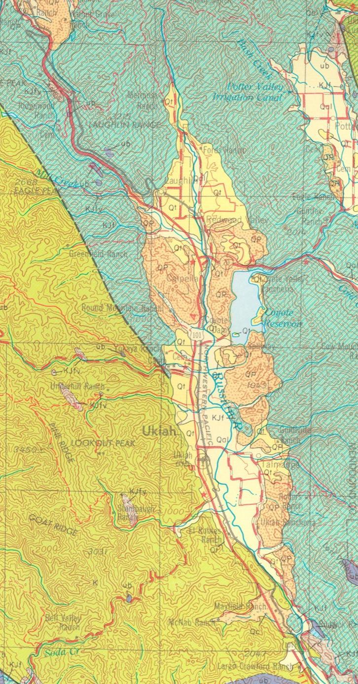
4 (Hopland) GROUNDWATER BASINS IN THE RUSSIAN RIVER WATERSHED
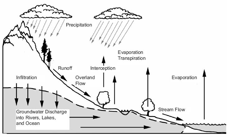
5 HYDROLOGIC CYCLE
6 REDWOOD, UKIAH, HOPLAND AND MCDOWELL VALLEYS Groundwater Basin Areal Extent Depth of Deposit Groundwater Well Production gallons per minute (gpm) Groundwater Storage Capacity Status of Ground water Level Redwood and Ukiah Valleys 59 sq. miles Alluvium ft.; Continental deposits 200 ft. Alluvium gpm Alluvium, terrace, river channel deposits, continental deposits: 324,000 ac-ft.; alluvium and terrace deposits only: ,000 ac-ft., river channel deposits only 35,000 ac-ft. Stable Hopland Valley 8.4 sq. miles Alluvium un- to semi confined - 50 ft.; Continental deposits ft. Alluvium 500 gpm; Continental deposits 1-50 gpm Alluvium 20,000 ac-ft. Stable McDowell Valley 2 sq. miles Alluvium 200 ft.; Continental deposits ft. Alluvium 500 gpm; Continental deposits 1-50 gpm Not available Stable From: California Department of Water Resources, California s Groundwater: North Coast Hydrologic Region Bulletin 118.
7 Franciscan Complex Franciscan Complex
8 Farrar, C.D Groundwater Resources in Mendocino County, California. U.S. Geological Survey. Water-Resources Investigations Report Cardwell, G. T., 1965, Geology and Groundwater in Russian River Valley Areas and in Round, Laytonville, and Little Lake Valleys, Sonoma and Mendocino Counties, California: U.S. Geological Survey, Water-Supply Paper 1548, scale 1:62,500.
9
10 From Farrar 1986


11 From Ca. Dept of Water Resources

12 CA. Department of Water Resources Water Library Groundwater level data


13 Redwood Valley groundwater movement Ukiah Valley groundwater movement Lines show direction of groundwater movement from the mountains on both sides of the valley towards the river and from upstream to downstream. From Farrar 1986.

14 Conclusion from Farrar study None of the hydrographs (of well levels) show any prominent long-term declines. Analysis of the hydrographs indicates that the ground-water reservoir is recharged fully each year except when precipitation falls below about 60 percent of normal. After 2 years of drought, the reservoir can be fully recharged by 1 year of normal or above-normal precipitation. This report notes the need for more well data. Hopland groundwater movement From Farrar 1986.

15 Connection to Salmonids: Flow in tributaries in Ukiah Valley varies with stage of Russian River


16 RIVER CHANNEL AND GROUNDWATER BASIN PRIOR TO RIVER CHANNEL ENTRENCHMENT MOUNTAINS River channel MOUNTAINS Groundwater basin in alluvial valley of Russian River RIVER CHANNEL AND GROUNDWATER BASIN AFTER RIVER CHANNEL ENTRENCHMENT SUMMER TIME GROUNDWATER LEVEL IS LOWER
17 Drop in ground water levels along creek coincides with the drop in flow levels in the main river channel. Drop is greatest in the well located closest to the Russian River indicating that the river s water surface elevation is controlling the groundwater level of the tributaries. Flow in both Morrison and Parsons Creeks went subterranean as soon as the water level in the mainstem river dropped. No juvenile steelhead could have migrated out of these creeks which have year round flow in their canyons. From Jackson and Marcus 2004


18 MOUNTAINS HIGH RIVER FLOW MOUNTAINS ALLUVIAL BASIN WITH GROUNDWATER ENTRENCHED RIVER CHANNEL DURING AND AFTER RAINSTORM- CREEK EXITING MOUNTAINS AND CROSSING ALLUVIAL BASIN MORRISON CREEK AT HIGH FLOW IN FEBRUARY 2009.

19 MOUNTAINS LOW RIVER FLOW MOUNTAINS Steep slope = rapid percolation ENTRENCHED RIVER CHANNEL ALLUVIAL BASIN WITH GROUNDWATER DURING AND AFTER RAINSTORM- CREEK EXITING MOUNTAINS AND CROSSING ALLUVIAL BASIN When stage of river is dropped water in tributary creek goes subterranean stranding any fish in the creek
20 ALEXANDER VALLEY Groundwater Basin Alexander Valley - Cloverdale sub-basin Alexander Valley - Alexander Valley subbasin Areal Extent 10 sq. miles 37 sq. miles Depth of Deposit Groundwater Well Production gallons per minute (gpm) Groundwater Storage Capacity Status of Ground water Level Alluvium ft. Alluvium gpm 55-71,000 ac-ft. Stable ft gpm 762,000 ac-ft. Stable From: California Department of Water Resources, California s Groundwater: North Coast Hydrologic Region Bulletin 118.


21 From: Metzger, L. E., C. D. Farrar, K.M. Koczot, and E. G. Reichard Geohydrology and Water Chemistry of the Alexander Valley, Sonoma County, California. U.S. Department of the Interior, U.S. Geological Survey.
 fills the groundwater basin atop a thick layer of Franciscan Complex (TKJF).")
22 Cross section A through the Cloverdale basin. From Metzger Cross section A depicts a section of the Cloverdale basin. A series of monitoring wells are also shown. The drilling logs for these wells were used to determine subsurface geology. In the Cloverdale basin recent alluvium (Qal) fills the groundwater basin atop a thick layer of Franciscan Complex (TKJF). In general Franciscan Complex is non-water bearing except where fractures occur.

23 Cross section B near Geyserville in the Alexander Valley basin. From Metzger Cross section B-B is located across the valley just north of Geyserville. It shows recent alluvium filling the Alexander Valley groundwater basin atop Franciscan Complex. The depth of alluvium is much greater than the Cloverdale basin.

24 Cross section C near Jimtown in the Alexander Valley basin. From Metzger Cross section C-C lies across the valley just to the north of Jimtown. It depicts more complex subsurface geology with wells accessing water in the relatively shallow recent alluvium and the thicker deposit of Glen Ellen Formation. Sonoma Volcanics and Franciscan Complex also occur in the cross section.

25 From: Ca. Dept of Water Resources


26 Groundwater levels 1980 Groundwater levels 2002 From Metzger 2006
27 Metzger et al (2006) completed a detailed review of nine well records in Alexander Valley and identified a slight decline in groundwater levels termed a small imbalance between groundwater use and recharge. This decline primarily occurred in wells between Geyserville and Jimtown. This report notes the small number of well records used and the need for more well data.
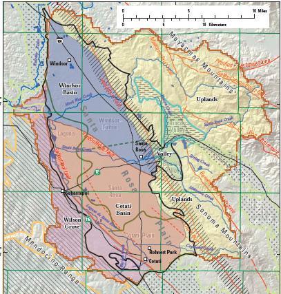
28 SANTA ROSA PLAIN Groundwater Basin Santa Rosa Valley - Healdsburg sub-basin Santa Rosa Valley - Santa Rosa subbasin Areal Extent 245 sq. miles 125 sq. miles Depth of Deposit Alluvium ft.; Wilson Grove Formation ft. Alluvium ft.; Wilson Grove Formation ft; Glen Ellen Formation ft. Groundwater Well Production gallons per minute (gpm) Alluvium gpm; Terrace deposits gpm; Glen Ellen Formation gpm Alluvium gpm; Wilson Grove Formation gpm; Glen Ellen Formation 10 gpm Groundwater Storage Capacity Status of Ground water Level 489,000 ac-ft. Stable 4,313,000 ac-ft. Stable From: California Department of Water Resources, California s Groundwater: North Coast Hydrologic Region Bulletin 118.

29 From: Nishikawa, Tracy ed Hydrologic and Geochemical Characterization of the Santa Rosa Plain Watershed, Sonoma County, CA. U.S. Geological Survey Scientific Investigations Report

30 From Nishikawa 2013

31 From Nishikawa 2013
32

33 From Nishikawa 2013

34 From Nishikawa 2013

35 From Nishikawa 2013


36 From Nishikawa


37 From Nishikawa
38 Summary from USGS report Nishikawa 2013 : Hydrogeology Groundwater is contained in the pore spaces of the Quaternary alluvial materials and Tertiary sedimentary rocks, including the Glen Ellen Formation, the Wilson Grove Formation, the Petaluma Formation, and Sonoma Volcanics. The source of natural recharge is precipitation falling on the Santa Rosa Plain and on the surrounding mountains. There is limited hydraulic communication between shallow and deeper aquifer systems There is limited groundwater underflow across the Rodgers Creek fault zone from the uplands to the Santa Rosa Plain. The Sebastopol fault could be a partial barrier to groundwater flow.
39 Water Use Reported public-supply pumpage averaged 6,800 acre-feet per year and makes up 18% of total groundwater use Estimated agricultural pumpage averaged 12,500 acre-feet per year and makes up 32% of total groundwater use Estimated domestic (rural residential) pumpage averaged 19,300 acre-feet per year and makes up 50% of total groundwater use Total evapotranspiration from the soil, unsaturated, and saturated zones estimated by a preliminary watershed model was about 265,700 acre-feet per year.
40 From Sonoma County Water Agency 2014
41 Groundwater movement The 1951 (predevelopment) water-level contour map shows that groundwater flowed from the Mayacmas and Sonoma Mountains westward toward the Laguna de Santa Rosa and eastward from the highlands toward the Laguna de Santa Rosa. The groundwater-level contour map also shows that groundwater moved toward, and discharged into, the stream channels, thereby, likely sustaining baseflow. Groundwater levels In the Windsor Basin storage unit, water levels were fairly steady with some seasonal variability, and some hydrographs showed the effects of the and droughts. In the Cotati Basin storage unit, water levels from wells in the area near Rohnert Park recovered to 1974 conditions by 2007 as a result of a large reduction in municipal pumping that began in From 1975 to 2010 annual loss has been around 3,300 acre feet per year primarily in deeper >200 ft wells. This represents 4% of the average total amount of groundwater flowing into the basin. However, because it is cumulative, the relatively small annual loss can lead to declines in groundwater levels and reduced water flows in creeks and streams.
42 Data Gaps Lack of depth-dependent water-level and water-quality data make it difficult to calibrate a groundwater-flow model by aquifer or layer. Additional water-quality data are needed to help explain variability in observed water-quality data in the Cotati Basin storage unit. Better estimates, or direct measurements, of agricultural and domestic pumpage are required to improve calibration of a numerical groundwater and surface-water flow model. The locations of these wells are often unknown or unreported; therefore, the locations of these wells should be determined.


43 Upper Mark West Creek Watershed From CEMAR 2015 CEMAR in conjunction with NOAA Fisheries evaluated a number of features of one area in Upper Mark West Creek located upstream of the confluence of Mark West and Humbug Creeks. Local residents had expressed concerns that these creeks were drying up when previously they had not and that upstream agricultural development and wineries were largely the cause. This 14 sq. mile section of the watershed receives an average of 46.3 inches of rainfall annually.

44 From CEMAR 2015 This study determined 158 acres of vineyard are located in this subset of the Upper Mark West Creek watershed. The study assumes a vineyard irrigation water demand of 0.3 ac-ft/acre/year for a total of 48 ac-ft. or 27% of the total It was determined there was a total of 222 houses with a footprint of 2.94 acres. Rural residential use of 245 gallons/day/household for the dry season totals 126 ac-ft/dry season or 72% of the total Winery water use was estimated at 1.83 ac-ft/year or 1% of the total The total water demand of ac-ft/year
45 From CEMAR 2015 The hydrographs from 3 stations in Mark West Creek do not show sudden large changes as direct diversions from the creek would cause. However for the relatively short period of record ( ) examined in this study low flow conditions dominated each summer season. The study hypothesizes that the use of wells by most homeowners and growers is responsible for the low flow conditions.


46 From CEMAR 2015 These 52 residential wells produce relatively low volumes of water. The proximity of several wells near the stream in the ash-flow tuff and sand/gravel geological formations which have a high potential stream flow depletion factor suggests that wells operating in this region could individually or cumulatively have adverse effects on stream flow in Mark West Creek during the dry season.

47 From CEMAR 2015 Groundwater seeping into Mark West Creek provides the primary source of water to Coho salmon and steelhead trout summer rearing habitat. Sonoma Volcanic rocks are the primary source of this groundwater. This geologic formation is also the primary source of water for rural residences.


48 This study reviewed the initial depth to water in the drilling logs for 35 wells built between the 1970's and Clusters of wells near houses were reviewed but only a weak trend of lower water level was found. The study also discussed the effects of a vineyard well in Franciscan Complex on a ridge top above the North Fork of Mark West Creek. The well produces 10 gpm and is likely accessing water in a fracture in the rock. The well would only reduce seepage into the creek from one fracture. Calculating in the vineyard water demand the well removed.016 cfs during the June to September irrigation period. This amount is not enough to dewater the North Fork Mark West Creek. The study suggests that the drought and a large deposit of gravel upstream of an undersized culvert at St. Helena Road are the primary causes of the dewatering of this creek. From CEMAR 2015

49 CEMAR evaluated rainfall, runoff and water demand as part of the Goldridge RCD (2013) plan for Green Valley Creek. The model estimated that 52% of rainfall becomes evapotranspiration, 41% becomes runoff and 7% recharges groundwater. Water demand was estimated as 0.67 acre feet per acre per year for vineyard irrigation for a total of 411 acre feet per year, and acre feet per rural residential building for a total of 405 acre feet per year.
50 Summary Groundwater in the Russian River is complex due to the highly variable geology There is a slight imbalance between extraction of water and recharge in two basins in Sonoma County There is no documented imbalance in the Redwood-Ukiah-Hopland valley basin There is inadequate data on groundwater levels and groundwater pumping in all the basins Groundwater is the primary source of water for summer rearing of salmonids Water use figures for vineyard irrigation in groundwater studies vary considerably: 0.25 ac-ft/acre/year in Dry Creek Valley, 0.6 ac-ft/acre/year in all valley floor areas, 0.67 ac-ft/acre/year in the Sebastopol area, 0.3 ac-ft/acre/year in Upper Mark West Creek, 0.79 ac-ft/acre/year for Ukiah Valley, 0.58 ac-ft/acre/year for Sonoma County. There needs to be clarification of these figures based on water use reporting from growers.
Russian River Independent Science Review Panel
 Russian River Independent Science Review Panel Laurel Marcus Executive Director Ca. Land Stewardship Institute (CLSI) Fish Friendly Farming Certification Program 550 Gateway Dr. #108 Napa, Ca. 94558 707
Conceptual Model of Stream Flow Processes for the Russian River Watershed. Chris Farrar
 Conceptual Model of Stream Flow Processes for the Russian River Watershed Chris Farrar Several features of creeks affect the interactions between surface and groundwater. This conceptual model uses the
WORKING DRAFT List of Figures Groundwater Sustainability Plan for Santa Rosa Plain Subbasin. Figure Number. Figure Title
 . WORKING DRAFT List of s Grodwater Sustainability Plan for Subbasin Number Title Plan Area Section 2-1 Plan Area 2-2 Elevation and Surface Water Features 2-3 Jurisdictional and Protected Areas 2-4a Historical
REDWOOD VALLEY SUBAREA
 Independent Science Review Panel Conceptual Model of Watershed Hydrology, Surface Water and Groundwater Interactions and Stream Ecology for the Russian River Watershed Appendices A-1 APPENDIX A A-2 REDWOOD
Mark S. Nordberg Geology and Groundwater Investigations Section North Central Region Office California Department of Water Resources
 Mark S. Nordberg Geology and Groundwater Investigations Section North Central Region Office California Department of Water Resources Ukiah Drought Workshop July 29, 2009 Groundwater 101 Groundwater is
Executive Summary. Water Quantity
 Executive Summary Stakeholders in the Rock-Glade Watershed have taken the initiative to proceed with watershed planning as provided by the State of Washington under the Watershed Management Act (Chapter
Napa Valley Groundwater Sustainability: A Basin Analysis Report for the Napa Valley Subbasin
 Napa Valley Groundwater Sustainability: A Basin Analysis Report for the Napa Valley Subbasin December 13, 2016 Napa County Board of Supervisors By Vicki Kretsinger Grabert and Reid Bryson Basin Analysis
3.1 Basin Description
 Chapter 3 3.1 Basin Description A description of the Study Area is provided in Bulletin 118 (California Department of Water Resources, 2003) with a significant portion of that description reprinted below
Appendix G: Supplemental Water Supply Information
 California Water Service 2015 Urban Water Management Plan Redwood Valley District Appendix G: Supplemental Water Supply Information DWR Groundwater Bulletin 118 DEPARTMENT OF WATER RESOURCES CALIFORNIA
Groundwater-Surface Water Interactions along the Hangman, California, and Rock Creeks, September 30, 2009
 Groundwater-Surface Water Interactions along the Hangman, California, and Rock Creeks, September 30, 2009 Abstract This data collection effort was required to complete recommendations in the Hangman Creek
Hydrogeology and Simulated Effects of Future Water Use and Drought in the North Fork Red River Alluvial Aquifer: Progress Report
 Hydrogeology and Simulated Effects of Future Water Use and Drought in the North Fork Red River Alluvial Aquifer: Progress Report Developed in partnership with the Oklahoma Water Resources Board S. Jerrod
DRAFT. REVISED Draft. Paso Robles Subbasin Groundwater Sustainability Plan Chapter 6
 REVISED Draft Paso Robles Subbasin Groundwater Sustainability Plan Chapter 6 Prepared for the Paso Robles Subbasin Cooperative Committee and the Groundwater Sustainability Agencies February 14, 2019 Paso
Case Study 2: Twenty-mile Creek Rock Fords
 Case Study : Twenty-mile Creek Rock Fords Location Crossing Description Washington. Okanagan National Forest. Methow Valley Ranger District. Chewuch river basin, East Chewuch Road. The Twenty-mile Creek
Soils, Hydrogeology, and Aquifer Properties. Philip B. Bedient 2006 Rice University
 Soils, Hydrogeology, and Aquifer Properties Philip B. Bedient 2006 Rice University Charbeneau, 2000. Basin Hydrologic Cycle Global Water Supply Distribution 3% of earth s water is fresh - 97% oceans 1%
Section 4: Model Development and Application
 Section 4: Model Development and Application The hydrologic model for the Wissahickon Act 167 study was built using GIS layers of land use, hydrologic soil groups, terrain and orthophotography. Within
APPENDIX 3B OCCURRENCE OF SIGNIFICANT RIVER ALLUVIUM AQUIFERS IN THE PLATEAU REGION
 Plateau Region Water Plan January 2011 APPENDIX 3B OCCURRENCE OF SIGNIFICANT RIVER ALLUVIUM AQUIFERS IN THE PLATEAU REGION Occurrence of Significant River Alluvium Aquifers in the Plateau Region Prepared
Napa Valley Groundwater Sustainability: A Basin Analysis Report for the Napa Valley Subbasin
 Napa Valley Groundwater Sustainability: A Basin Analysis Report for the Napa Valley Subbasin A report prepared pursuant to California Water Code Section 10733.6(b)(3) EXECUTIVE SUMMARY (354.4(A)) 1 1.0
Napa County Comprehensive Groundwater Monitoring Program 2015 Annual Report and CASGEM Update
 Napa County Comprehensive Groundwater Monitoring Program 2015 Annual Report and CASGEM Update April 21, 2016 Watershed Information & Conservation Council By Vicki Kretsinger Grabert Overview Evolving groundwater
Sacramento Valley Groundwater Basin, Sutter Subbasin
 Sacramento Valley Groundwater Basin, Sutter Subbasin Groundwater Basin Number: 5-21.62 County: Sutter Surface Area: 234,400 acres (366 square miles) Boundaries and Hydrology The Sutter Subbasin lies in
Each basin is surrounded & defined by a drainage divide (high point from which water flows away) Channel initiation
 Channel initiation") DRAINAGE BASINS A drainage basin or watershed is defined from a downstream point, working upstream, to include all of the hillslope & channel areas which drain to that point Each basin is surrounded &
DRAINAGE BASINS A drainage basin or watershed is defined from a downstream point, working upstream, to include all of the hillslope & channel areas which drain to that point Each basin is surrounded &
Hydrogeologic Conceptual Models for Regional Flow Systems
 Hydrogeologic Conceptual Models for Regional Flow Systems R.T. Hanson, U.S. Geological Survey One Water Hydrologic Flow Model USGS MODFLOW-OWHM Session 4 Groundwater Subbasin Baseline Historic and Current
Betsy Stevenson and Allison Mohrs (Skagit County Planning and Development Services) Jenny Baker, The Nature Conservancy
 Jenny Baker, The Nature Conservancy") TC Fisher Slough Final Design and Permitting Subject: Well Review Memorandum To: From: Betsy Stevenson and Allison Mohrs (Skagit County Planning and Development Services) Jenny Baker, The ature Conservancy
TC Fisher Slough Final Design and Permitting Subject: Well Review Memorandum To: From: Betsy Stevenson and Allison Mohrs (Skagit County Planning and Development Services) Jenny Baker, The ature Conservancy
Dennis Jackson - Hydrologist 2096 Redwood Drive Santa Cruz, CA (831)
") February 11, 2011 Dennis Jackson - Hydrologist 2096 Redwood Drive Santa Cruz, CA 95060 (831) 295-4413 dennisjack01@att.net Tom Lippe 329 Bryant Street, Suite 3D San Francisco, CA 94107 Re: Additional Information
February 11, 2011 Dennis Jackson - Hydrologist 2096 Redwood Drive Santa Cruz, CA 95060 (831) 295-4413 dennisjack01@att.net Tom Lippe 329 Bryant Street, Suite 3D San Francisco, CA 94107 Re: Additional Information
Information Pamphlet 8 WATER LEVELS IN THE UPPER WEST BENCH ALLUVIAL AQUIFER, RED LODGE, MONTANA
 Ground Water Assessment Program Information Pamphlet 8 WATER LEVELS IN THE UPPER WEST BENCH ALLUVIAL AQUIFER, RED LODGE, MONTANA Camela Carstarphen, Thomas Patton, and John I. LaFave View of Remington
WATER ON AND UNDER GROUND. Objectives. The Hydrologic Cycle
 WATER ON AND UNDER GROUND Objectives Define and describe the hydrologic cycle. Identify the basic characteristics of streams. Define drainage basin. Describe how floods occur and what factors may make
Chapter 3. Description of the Study Area. Karl Taboga, James Stafford and Paul Taucher 3-19
 Chapter 3 Description of the Study Area Karl Taboga, James Stafford and Paul Taucher 3-19 T his study examines groundwater resources that underlie the Bear River drainage basin in Wyoming as well as areas
12 SWAT USER S MANUAL, VERSION 98.1
 12 SWAT USER S MANUAL, VERSION 98.1 CANOPY STORAGE. Canopy storage is the water intercepted by vegetative surfaces (the canopy) where it is held and made available for evaporation. When using the curve
Fluvial Driven Alluvial Fans
 Fluvial Driven Alluvial Fans Restoration Project Evaluations - Examples from the Russian and Napa River Watersheds Mia Docto Masters Thesis UC Berkeley 1. Basic Fan Description 2. Fluvial Driven Fan Characteristics
Cuyama Basin North Fork Vineyard
 Cuyama Basin North Fork Vineyard Company Background plus Data Insights to Support GSP Development for the Cuyama Basin Presented by Grapevine Capital Partners and Cleath-Harris Geologists April 26th, 2018
2. PHYSICAL SETTING FINAL GROUNDWATER MANAGEMENT PLAN. 2.1 Topography. 2.2 Climate
 FINAL GROUNDWATER MANAGEMENT PLAN 2. PHYSICAL SETTING Lassen County is a topographically diverse area at the confluence of the Cascade Range, Modoc Plateau, Sierra Nevada and Basin and Range geologic provinces.
Appendix G. Summary of Hydrogeologic Conditions and Historical Mining Northwest of the Centro Subarea in the Randsburg, Red Mountain, and Atolia Area
 Appendix G Summary of Hydrogeologic Conditions and Historical Mining Northwest of the Centro Subarea in the Randsburg, Red Mountain, and Atolia Area 1.1 Background This appendix provides a summary of hydrogeologic
ENGINEER S CERTIFICATION OF FAULT AREA DEMONSTRATION (40 CFR )
") PLATTE RIVER POWER AUTHORITY RAWHIDE ENERGY STATION BOTTOM ASH TRANSFER (BAT) IMPOUNDMENTS LARIMER COUNTY, CO ENGINEER S CERTIFICATION OF FAULT AREA DEMONSTRATION (40 CFR 257.62) FOR COAL COMBUSTION RESIDUALS
PLATTE RIVER POWER AUTHORITY RAWHIDE ENERGY STATION BOTTOM ASH TRANSFER (BAT) IMPOUNDMENTS LARIMER COUNTY, CO ENGINEER S CERTIFICATION OF FAULT AREA DEMONSTRATION (40 CFR 257.62) FOR COAL COMBUSTION RESIDUALS
Rucker Pond. Background
 Rucker Pond Background The Rucker Basin consists of two subbasins (East and West) that drain to a single area known as Rucker Pond. Both subbasins have the same hydraulic parameters, but have different
APPENDIX E. GEOMORPHOLOGICAL MONTORING REPORT Prepared by Steve Vrooman, Keystone Restoration Ecology September 2013
 APPENDIX E GEOMORPHOLOGICAL MONTORING REPORT Prepared by Steve Vrooman, Keystone Restoration Ecology September 2 Introduction Keystone Restoration Ecology (KRE) conducted geomorphological monitoring in
,Baynes Lake. TO...?&.?...A 2...KO.?'!!&... Sr. *logical Engineer
 > i evernment OF BRITISH COLUMBIA a TO...?&.?...A 2....KO.?'!!&... Sr. *logical Engineer... Grou,,water. Section Hydrology Division Wat.er... In~.~s.tiga.ti.On.s..Branck.... 5 u BJECT...C;.roun.dw.ater...Snve
Aquifer an underground zone or layer of sand, gravel, or porous rock that is saturated with water.
 Aggradation raising of the streambed by deposition that occurs when the energy of the water flowing through a stream reach is insufficient to transport sediment conveyed from upstream. Alluvium a general
The Owens River Valley: A Dry Lake and a Water Controversy. the ongoing battle between the Los Angeles Department of Water and Power and the
 Balzano 1 Andrea Balzano G188 Final Essay 12 June 2012 Abstract The Owens River Valley: A Dry Lake and a Water Controversy The Owens River Valley is a prime example of the water issues California faces
Hydrologic Modelling of the Upper Malaprabha Catchment using ArcView SWAT
 Hydrologic Modelling of the Upper Malaprabha Catchment using ArcView SWAT Technical briefs are short summaries of the models used in the project aimed at nontechnical readers. The aim of the PES India
Laboratory Exercise #3 The Hydrologic Cycle and Running Water Processes
 Laboratory Exercise #3 The Hydrologic Cycle and Running Water Processes page - 1 Section A - The Hydrologic Cycle Figure 1 illustrates the hydrologic cycle which quantifies how water is cycled throughout
Today I will describe the groundwater/surface water interaction in the CRB in Mosier basin.
 Today I will describe the groundwater/surface water interaction in the CRB in Mosier basin. 1 Ken Lite, studying groundwater resource in Mosier basin since 1980 s (photo by A. Bouchier) 2012 with Jonathan
Description DESCRIPTION
 DESCRIPTION The location of the Upper James Watershed is located in northeastern South Dakota as well as southeastern North Dakota. It includes the following counties located in North Dakota Barnes, Dickey,
Critical Aquifer Recharge Area Susceptibility Index Methodology
 Prepared for 207 4th Ave. N. Kelso, WA 98626 Prepared by Parametrix 700 NE Multnomah, Suite 1000 Portland, OR 97232-4110 T. 503.233.2400 T. 360.694.5020 F. 1.855.542.6353 www.parametrix.com July 5, 2016
mountain rivers fixed channel boundaries (bedrock banks and bed) high transport capacity low storage input output
 high transport capacity low storage input output") mountain rivers fixed channel boundaries (bedrock banks and bed) high transport capacity low storage input output strong interaction between streams & hillslopes Sediment Budgets for Mountain Rivers Little
mountain rivers fixed channel boundaries (bedrock banks and bed) high transport capacity low storage input output strong interaction between streams & hillslopes Sediment Budgets for Mountain Rivers Little
Groundwater Hydrology
 EXERCISE 12 Groundwater Hydrology INTRODUCTION Groundwater is an important component of the hydrologic cycle. It feeds lakes, rivers, wetlands, and reservoirs; it supplies water for domestic, municipal,
Which map shows the stream drainage pattern that most likely formed on the surface of this volcano? A) B)
 B)") 1. When snow cover on the land melts, the water will most likely become surface runoff if the land surface is A) frozen B) porous C) grass covered D) unconsolidated gravel Base your answers to questions
1. When snow cover on the land melts, the water will most likely become surface runoff if the land surface is A) frozen B) porous C) grass covered D) unconsolidated gravel Base your answers to questions
Wisconsin s Hydrogeology: an overview
 2012 Soil and Water Conservation Society Conference Stevens Point, WI Feb 9, 2012 Wisconsin s Hydrogeology: an overview Ken Bradbury Wisconsin Geological and Natural History Survey University of Wisconsin-Extension
Final Report for the Green Valley Creek Winter Refugia Enhancement Project Monitoring December 2016
 Final Report for the Green Valley Creek Winter Refugia Enhancement Project Monitoring December 2016 Prepared by: Mariska Obedzinski and Sarah Nossaman University of California Cooperative Extension & California
Illinois Drought Update, December 1, 2005 DROUGHT RESPONSE TASK FORCE Illinois State Water Survey, Department of Natural Resources
 Illinois Drought Update, December 1, 2005 DROUGHT RESPONSE TASK FORCE Illinois State Water Survey, Department of Natural Resources For more drought information please go to http://www.sws.uiuc.edu/. SUMMARY.
Hydrogeology of East-Central Union County, Northeastern New Mexico
 Hydrogeology of East-Central Union County, Northeastern New Mexico Geoffrey Rawling April 2013 New Mexico Bureau of Geology & Mineral Resources 1 What are the important hydrogeologic issues in Union County?
SELBY CREEK STREAM HABITAT RESTORATION AND RIPARIAN REVEGETATION PROJECT: GEOMORPHIC ANALYSIS AND REVIEW
 SELBY CREEK STREAM HABITAT RESTORATION AND RIPARIAN REVEGETATION PROJECT: GEOMORPHIC ANALYSIS AND REVIEW Submitted to Bioengineering Institute P.O. Box 1554 Laytonville, CA 95454 By Matthew O Connor, PhD,
Laboratory Exercise #4 Geologic Surface Processes in Dry Lands
 Page - 1 Laboratory Exercise #4 Geologic Surface Processes in Dry Lands Section A Overview of Lands with Dry Climates The definition of a dry climate is tied to an understanding of the hydrologic cycle
GAM Run by Ali H. Chowdhury Ph.D., P.G. Texas Water Development Board Groundwater Resources Division (512)
") GAM Run 7-18 by Ali H. Chowdhury Ph.D., P.G. Texas Water Development Board Groundwater Resources Division (512) 936-0834 July 13, 2007 EXECUTIVE SUMMARY The groundwater availability model for the Hill
GAM Run 7-18 by Ali H. Chowdhury Ph.D., P.G. Texas Water Development Board Groundwater Resources Division (512) 936-0834 July 13, 2007 EXECUTIVE SUMMARY The groundwater availability model for the Hill
Groundwater. (x 1000 km 3 /y) Reservoirs. Oceans Cover >70% of Surface. Groundwater and the. Hydrologic Cycle
 Reservoirs. Oceans Cover >70% of Surface. Groundwater and the. Hydrologic Cycle") Chapter 13 Oceans Cover >70% of Surface Groundwater and the Hydrologic Cycle Oceans are only 0.025% of Mass Groundwater Groundwater is liquid water that lies in the subsurface in fractures in rocks and
Chapter 13 Oceans Cover >70% of Surface Groundwater and the Hydrologic Cycle Oceans are only 0.025% of Mass Groundwater Groundwater is liquid water that lies in the subsurface in fractures in rocks and
TAMPA BAY TRIBUTARIES BASIN. Hydrogeological Setting
 TAMPA BAY TRIBUTARIES BASIN Hydrogeological Setting Aquifers within the Tampa Bay Tributaries Basins ground water flow system include the Floridan aquifer system, the intermediate aquifer system, and the
Assignment 1. Measuring River Characteristics- Vernon Creek. Applied Fluvial Geomorphology Field Techniques EESc 435
 Assignment 1 Measuring River Characteristics- Vernon Creek Applied Fluvial Geomorphology Field Techniques EESc 435 Amanda Jardine 30100093 Jaime McDonald 14177083 Erica Massey 50870088 April 28, 2012 Introduction
UGRC 144 Science and Technology in Our Lives/Geohazards
 UGRC 144 Science and Technology in Our Lives/Geohazards Flood and Flood Hazards Dr. Patrick Asamoah Sakyi Department of Earth Science, UG, Legon College of Education School of Continuing and Distance Education
SECTION G SEDIMENT BUDGET
 SECTION G SEDIMENT BUDGET INTRODUCTION A sediment budget has been constructed for the for the time period 1952-2000. The purpose of the sediment budget is to determine the relative importance of different
Challenges in Calibrating a Large Watershed Model with Varying Hydrogeologic Conditions
 Challenges in Calibrating a Large Watershed Model with Varying Hydrogeologic Conditions Presented by Johnathan R. Bumgarner, P.G., Celine A.L. Louwers, & Monica P. Suarez, P.E. In cooperation with the
INTRODUCTION. LOCATION OF THE STUDY AREA. DRILLING HISTORY OF THE AREA. GEOLOGY AND HYDROGEOLOGY OF THE AREA. HYDROLOGY OF THE AREA.
 INTRODUCTION. LOCATION OF THE STUDY AREA. DRILLING HISTORY OF THE AREA. GEOLOGY AND HYDROGEOLOGY OF THE AREA. HYDROLOGY OF THE AREA. RESULT ANALYSIS AND INTERPRETATION. DISCUSSION. RECOMMENDATION AND CONCLUSION.
The subject paper is being submitted for approval for publication in the annual volume entitled Geological Survey Research.
 Water Resources Division 345 Middlefield Road Menlo Park, California January 12, 1965 Memorandum To: Mr. Frank E. Clark, Chief, General Hydrology Branch Thru: Area Hydrologist PCA From: Valmore C. LaMarche
Prof. Stephen A. Nelson EENS 111. Groundwater
 Page 1 of 8 Prof. Stephen A. Nelson EENS 111 Tulane University Physical Geology This page last updated on 20-Oct-2003 is water that exists in the pore spaces and fractures in rock and sediment beneath
Surface Processes Focus on Mass Wasting (Chapter 10)
") Surface Processes Focus on Mass Wasting (Chapter 10) 1. What is the distinction between weathering, mass wasting, and erosion? 2. What is the controlling force in mass wasting? What force provides resistance?
Surface Processes Focus on Mass Wasting (Chapter 10) 1. What is the distinction between weathering, mass wasting, and erosion? 2. What is the controlling force in mass wasting? What force provides resistance?
Groundwater Resources of Missouri. Cynthia Brookshire, R. G.
 Groundwater Resources of Missouri Cynthia Brookshire, R. G. GROUNDWATER... Water beneath the Earth s surface within a zone of saturation AQUIFER... A geologic formation or group of formations that are
Water on the Earth. The distribution of all the water found on the earth's surface.
 Earth s Waters This is one of the water canals of the present-day system in Phoenix, Arizona. These canals were reconstructed from a system that was built by American Indians, then abandoned. Phoenix is
2.5.3 Willow Creek Valley
 2.5.3 Willow Creek Valley Identified as a priority groundwater basin based on stakeholder input, land use, water source patterns, and existing groundwater well infrastructure, Willow Creek Valley is in
Columbia Estuary Province
 Rolling Provincial Review: Implementation 2001-2004 Province 73 Columbia Basin Fish & Wildlife Authority Province FY 2001-2004 Spending Summaries NPCC Recommendations and BPA Spending by Project Category,
Chapter 10 - Sacramento Method Examples
 Chapter 10 Sacramento Method Examples Introduction Overview This chapter presents two example problems to demonstrate the use of the Sacramento method. These example problems use the SACPRE and HEC-1 computer
SEASONAL WATER STORAGE AND REPLENISHMENT OF A FRACTURED GRANITE AQUIFER USING ASR WELLS
 SEASONAL WATER STORAGE AND REPLENISHMENT OF A FRACTURED GRANITE AQUIFER USING ASR WELLS Mario R. Lluria; Phillip M. Paski; Gary G. Small HydroSystems, Incorporated Phoenix, Arizona USA Presentation Contents
CASE STUDY #9 - Brushy Fork Dam, Sugar Grove, West Virginia
 CASE STUDY #9 - Brushy Fork Dam, Sugar Grove, West Virginia Brushy Fork Dam is a flood control structure built by the Soil Conservation Service southeast of the city of Franklin in Pendleton County, West
Lower Tuolumne River Accretion (La Grange to Modesto) Estimated daily flows ( ) for the Operations Model Don Pedro Project Relicensing
 Estimated daily flows ( ) for the Operations Model Don Pedro Project Relicensing") Lower Tuolumne River Accretion (La Grange to Modesto) Estimated daily flows (1970-2010) for the Operations Model Don Pedro Project Relicensing 1.0 Objective Using available data, develop a daily time series
Lower Tuolumne River Accretion (La Grange to Modesto) Estimated daily flows (1970-2010) for the Operations Model Don Pedro Project Relicensing 1.0 Objective Using available data, develop a daily time series
Seismic Reflection Imaging across the Johnson Ranch, Valley County, Idaho
 Seismic Reflection Imaging across the Johnson Ranch, Valley County, Idaho Report Prepared for the Skyline Corporation Lee M. Liberty Center for Geophysical Investigation of the Shallow Subsurface (CGISS)
Hydrology and Hydraulics Design Report. Background Summary
 To: National Park Services Montezuma Castle National Monument Richard Goepfrich, Facility Manager From: Multicultural Technical Engineers Date: Tuesday - February 13, 2018 Subject: 30% Hydrology and Hydraulics
Glacial Deposition and Groundwater in Dutchess County
 Glacial Deposition and Groundwater in Dutchess County Name: Period: Thousands of years ago an enormous ice sheet blanketed the Hudson Valley in what was called the Wisconsinan Glaciation. The ice reshaped
STUDY GUIDE FOR CONTENT MASTERY. Surface Water Movement
 Surface Water SECTION 9.1 Surface Water Movement In your textbook, read about surface water and the way in which it moves sediment. Complete each statement. 1. An excessive amount of water flowing downslope
Water Resources Challenges in Adams County, Pennsylvania
 Water Resources Challenges in Adams County, Pennsylvania Water Availability in the Upper Monocacy River Basin (Marsh, Rock, Alloway, and Toms Creeks) May 13, 2010 Cherie Schultz, Ph.D. Interstate Commission
Solutions to Flooding on Pescadero Creek Road
 Hydrology Hydraulics Geomorphology Design Field Services Photo courtesy Half Moon Bay Review Solutions to Flooding on Pescadero Creek Road Prepared for: San Mateo County Resource Conservation District
ADDRESSING GEOMORPHIC AND HYDRAULIC CONTROLS IN OFF-CHANNEL HABITAT DESIGN
 ADDRESSING GEOMORPHIC AND HYDRAULIC CONTROLS IN OFF-CHANNEL HABITAT DESIGN Conor Shea - Hydrologist U.S. Fish and Wildlife Service Conservation Partnerships Program Arcata, CA Learning Objectives Examine
Bert Rapp, PE Upper Ventura River Basin GSA Formation Committee
 TO: FROM: Bert Rapp, PE Upper Ventura River Basin GSA Formation Committee Jordan Kear, P.G., C.Hg. Kear Groundwater PO Box 2601 Santa Barbara, CA 93120-2601 DATE: March 17, 2016 SUBJECT: Memorandum re:
Dan Miller + Kelly Burnett, Kelly Christiansen, Sharon Clarke, Lee Benda. GOAL Predict Channel Characteristics in Space and Time
 Broad-Scale Models Dan Miller + Kelly Burnett, Kelly Christiansen, Sharon Clarke, Lee Benda GOAL Predict Channel Characteristics in Space and Time Assess Potential for Fish Use and Productivity Assess
TECHNICAL MEMORANDUM: MADERA SUBBASIN. Sustainable Groundwater Management Act (SGMA) DRAFT PRELIMINARY BASIN BOUNDARY WATER BUDGET.
 DRAFT PRELIMINARY BASIN BOUNDARY WATER BUDGET.") TECHNICAL MEMORANDUM: MADERA SUBBASIN Sustainable Groundwater Management Act (SGMA) DRAFT PRELIMINARY BASIN BOUNDARY WATER BUDGET Prepared by February 2018 DRAFT PRELIMINARY Technical Memorandum: Madera
TECHNICAL MEMORANDUM: MADERA SUBBASIN Sustainable Groundwater Management Act (SGMA) DRAFT PRELIMINARY BASIN BOUNDARY WATER BUDGET Prepared by February 2018 DRAFT PRELIMINARY Technical Memorandum: Madera
THE CASPAR CREEK EXPERIMENTAL WATERSHED. Thomas Lisle, Hydrologist Pacific Southwest Forest and Range Experiment Station Arcata, Califorina
 THE CASPAR CREEK EXPERIMENTAL WATERSHED Thomas Lisle, Hydrologist Pacific Southwest Forest and Range Experiment Station Arcata, Califorina The Caspar Creek Experimental Watershed was set up as a traditional
Hannah Moore CEE Juvenile Bull Trout Distribution in the South Fork Walla Walla River, Oregon
 Hannah Moore CEE 6440 Juvenile Bull Trout Distribution in the South Fork Walla Walla River, Oregon Introduction Bull trout (Salvelinus confluentus) are an endangered species historically found throughout
Legislative Subcommittee to Study Water. March 9, 2016
 Barrick Gold Corporation Legislative Subcommittee to Study Water March 9, 2016 EXHIBIT F - WATER Document consists of 17 pages. Entire exhibit provided. Meeting Date: 3-9-16 PERSHING Barrick Nevada Mines
Stream Geomorphology. Leslie A. Morrissey UVM July 25, 2012
 Stream Geomorphology Leslie A. Morrissey UVM July 25, 2012 What Functions do Healthy Streams Provide? Flood mitigation Water supply Water quality Sediment storage and transport Habitat Recreation Transportation
11/12/2014. Running Water. Introduction. Water on Earth. The Hydrologic Cycle. Fluid Flow
 Introduction Mercury, Venus, Earth and Mars share a similar history, but Earth is the only terrestrial planet with abundant water! Mercury is too small and hot Venus has a runaway green house effect so
Groundwater. (x 1000 km 3 /y) Oceans Cover >70% of Surface. Groundwater and the. Hydrologic Cycle
 Oceans Cover >70% of Surface. Groundwater and the. Hydrologic Cycle") Chapter 17 Oceans Cover >70% of Surface Groundwater and the Hydrologic Cycle Vasey s Paradise, GCNP Oceans are only 0.025% of Mass Groundwater Groundwater is liquid water that lies in the subsurface in
Chapter 17 Oceans Cover >70% of Surface Groundwater and the Hydrologic Cycle Vasey s Paradise, GCNP Oceans are only 0.025% of Mass Groundwater Groundwater is liquid water that lies in the subsurface in
INFLOW DESIGN FLOOD CONTROL SYSTEM PLAN 40 C.F.R. PART PLANT YATES ASH POND 2 (AP-2) GEORGIA POWER COMPANY
 GEORGIA POWER COMPANY") INFLOW DESIGN FLOOD CONTROL SYSTEM PLAN 40 C.F.R. PART 257.82 PLANT YATES ASH POND 2 (AP-2) GEORGIA POWER COMPANY EPA s Disposal of Coal Combustion Residuals from Electric Utilities Final Rule (40 C.F.R.
INFLOW DESIGN FLOOD CONTROL SYSTEM PLAN 40 C.F.R. PART 257.82 PLANT YATES ASH POND 2 (AP-2) GEORGIA POWER COMPANY EPA s Disposal of Coal Combustion Residuals from Electric Utilities Final Rule (40 C.F.R.
9. PROBABLE MAXIMUM PRECIPITATION AND PROBABLE MAXIMUM FLOOD
 9. PROBABLE MAXIMUM PRECIPITATION AND PROBABLE MAXIMUM FLOOD 9.1. Introduction Due to the size of Watana Dam and the economic importance of the Project to the Railbelt, the Probable Maximum Flood (PMF)
ODFW AQUATIC INVENTORY PROJECT OREGON PLAN FOR SALMON & WATERSHEDS STREAM RESTORATION HABITAT REPORT
 ODFW AQUATIC INVENTORY PROJECT OREGON PLAN FOR SALMON & WATERSHEDS STREAM RESTORATION HABITAT REPORT STREAM: BASIN: SURVEY TYPE: Munson Creek (NC-342) Tillamook River Post-Tx DATE: February 2, 28 SURVEY
Your web browser (Safari 7) is out of date. For more security, comfort and the best experience on this site: Update your browser Ignore
 is out of date. For more security, comfort and the best experience on this site: Update your browser Ignore") Your web browser (Safari 7) is out of date. For more security, comfort and the best experience on this site: Update your browser Ignore ALLU VIAL FAN colluvial fan, debris cone For the complete encyclopedic
Your web browser (Safari 7) is out of date. For more security, comfort and the best experience on this site: Update your browser Ignore ALLU VIAL FAN colluvial fan, debris cone For the complete encyclopedic
Michigan s Geology and Groundwater
 Michigan s Geology and Groundwater Ralph J. Haefner Deputy Director U.S. Geological Survey Michigan-Ohio Water Science Center Lansing, Michigan Outline About the USGS Geology 101 Michigan s geology Bedrock
KANSAS GEOLOGICAL SURVEY Open File Report LAND SUBSIDENCE KIOWA COUNTY, KANSAS. May 2, 2007
 KANSAS GEOLOGICAL SURVEY Open File Report 2007-22 LAND SUBSIDENCE KIOWA COUNTY, KANSAS Prepared by Michael T. Dealy L.G., Manager, Wichita Operations SITE LOCATION The site was approximately four miles
LAKE WHATCOM WATER AND SEWER DISTRICT COMPREHENSIVE SEWER PLAN UPDATE EXHIBIT N. STUDY AREA CHARACTERISTICS
 LAKE WHATCOM WATER AND SEWER DISTRICT COMPREHENSIVE SEWER PLAN - 2014 UPDATE EXHIBIT N. STUDY AREA CHARACTERISTICS EXHIBIT N - STUDY AREA CHARACTERISTICS A. Sudden Valley Sudden Valley is a planned community
IPMO2-1. Groundwater Modelling of Chiang Rai Basin, Northern Thailand. Sattaya Intanum* Dr.Schradh Saenton**
 IPMO2-1 Groundwater Modelling of Chiang Rai Basin, Northern Thailand Sattaya Intanum* Dr.Schradh Saenton** ABSTRACT Chiang Rai basin, situated in Chiang Rai and Phayao provinces covering an area of 11,000
Field Observations and One-Dimensional Flow Modeling of Summit Creek in Mack Park, Smithfield, Utah
 Intermountain Center for River Rehabilitation and Restoration, Utah State University 31 July 2018 Field Observations and One-Dimensional Flow Modeling of Summit Creek in Mack Park, Smithfield, Utah I.
IDAWRA: Groundwater-flow model for the Wood River Valley aquifer system, south-central Idaho February 1, 2017, 11:30-1:00
 Idaho Section of the American Water Resources Association IDAWRA: Groundwater-flow model for the Wood River Valley aquifer system, south-central Idaho A three-dimensional numerical model of groundwater
AWRA PMAS Engineers Club of Philadelphia. A Geologic Perspective on Stormwater
 AWRA PMAS Engineers Club of Philadelphia A Geologic Perspective on Stormwater Toby J. Kessler, P.G. Hydrogeologist Trevor G. Woodward, P.G. Engineering Geologist September 10, 2014 Gilmore & Associates,
Chapter 5 CALIBRATION AND VERIFICATION
 Chapter 5 CALIBRATION AND VERIFICATION This chapter contains the calibration procedure and data used for the LSC existing conditions model. The goal of the calibration effort was to develop a hydraulic
Illinois State Water Survey Division
 Illinois State Water Survey Division SURFACE WATER SECTION SWS Contract Report 413 AT THE UNIVERSITY OF ILLINOIS SEDIMENTATION SURVEY OF DAWSON LAKE, MORAINE VIEW STATE PARK, MC LEAN COUNTY, ILLINOIS by
River Response. Sediment Water Wood. Confinement. Bank material. Channel morphology. Valley slope. Riparian vegetation.
 River Response River Response Sediment Water Wood Confinement Valley slope Channel morphology Bank material Flow obstructions Riparian vegetation climate catchment vegetation hydrological regime channel