LITHIUM SALT LAKES POWERING THE FUTURE
|
|
|
- Mabel Montgomery
- 5 years ago
- Views:
Transcription

1 LITHIUM SALT LAKES POWERING THE FUTURE

2 Salt lakes & their mineral wealth Salt lakes are an important source of lithium (batteries), potassium (fertiliser) and boron (flux, fibre glass etc) Lakes include permanent water bodies i.e. Dead Sea, Great Salt Lake (USA) But most commonly seasonally flooded dry lakes Andes of Argentina, Chile, Bolivia; Nevada and Utah USA; Qinghai Basin NW China; Central Australia Referred to as Playas, Salars, Salt Lakes, Dry lakes etc Global distribution, related to geology and climate Minerals and brine chemistry different from major marine evaporite deposits producing potash in Canada, USA, Europe, Africa

3 Global distribution lithium brine Source USGS

4 Global distribution potash brine Source GA Sources GA


5 Lithium uses Key demand drivers are: Electronic devices Electric cars Electricity storage i.e. Tesla Powerwall battery storage Glass production Other industrial applications Use of battery grade lithium in portable electronic devices has grown by ~20% annually since 2000

6 Supply challenges One of few commodities with positive pricing expectations Highly concentrated supply chain Owned by large chemical companies Large industrial end users, LG Chem, Foxconn, Boston Power, Tesla, BYD Limited economic deposits Regulatory & environmental constraints in Chile Limited supply supporting prices Attracting new aspiring hard rock and clay resource developers Sources Orocobre 2015
7 Salt lake types Houston (2011) divided salt lakes into two broad types Mature dominated by evaporites (halite, gypsum) Immature dominated by clay, silt, sand/gravel 1 st generation lithium and potash developments dominantly mature salt lakes (pre-2000) 2 nd /new generation of salt lake development mostly immature salt lakes (2009 onward) Sedimentation controlled by: Climate dry periods facilitate evaporite deposition, wet periods coarser sediment deposition Tectonics changing the geometry of depressions, uplifting mountains for erosion
8 Salt lake locations - Argentina Olaroz Cauchari Salinas Grandes Rincon
9 Brine deposit key ingredients Lithium source (acid volcanic rocks - Miocene & younger in Lithium Triangle; volcanic glasses) Hot springs associated with volcanos or leaching of volcanic rocks. Associated boron and potassium Chemical ratios important for processing Low Mg/Li, low SO4/Li Potassium source weathering of micas and feldspars. Deposits more widespread than lithium, as sources more varied Tectonic/topographic control Andes - Internal drainage, thick sediments in tectonic depressions Central Australia - Lower topography, potash deposits in broad depressions and channels Arid climate Evaporation >> seasonal rainfall, evaporative concentration generating hypersaline brines

10 Li source in the Andean plateau Source Houston et. Al., 2011
11 Salt lake geology Halite units, 10 s to hundreds of metres thick. Halite porosity generally decreases with depth, Good aquifers near surface, with primary and secondary fracture porosity/permeability (Basal) coarse gravel and sand in some Andean basins prime aquifers Sourced from alluvial fans, wet climatic periods Upper fine grained silt and clay sequences, often with organic rich silts Essentially leaky aquitards Sedimentation reflects climatic situation, water balance and tectonics Upper Tertiary felsic volcanics/hot springs in the catchment


12 Salt layers at surface or depth Salt crusts vary from zero thickness to hundreds of metres thick, reflecting climatic conditions, hydrology and the salt balance in each individual basin Salt lakes dominated by halite have very different hydraulic properties to those dominated by clastic material The halite nucleus is typically thicker than at the lake margins


13 Andean basin geology Olaroz Seasonal flooding Tectonic uplift generating alluvial fans Perennial to ephemeral river inflows Alluvial fans Source Houston, 2011


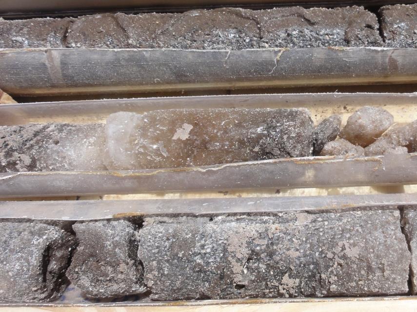
14 Lithologies Clays, silts Organic silts Porous halite Compact halite


15 Salt lake locations - Argentina Olaroz Cauchari Salinas Grandes Rincon
 400 mg/l Li and 8000 mg/l K Effective porosity to 40% Ovejero, Toledo et. Al.")
16 West Atacama Mature salt lake examples - Rincon Olaroz (Immature) East Cavities Cavities Hombre Muerto Compact Sand bed Surface salt crust Cavity/recrystallised Banded halite Evapofacies halite Mud flat Halite evapofacies beds Piezometric surface (0.3 m) 400 mg/l Li and 8000 mg/l K Effective porosity to 40% Ovejero, Toledo et. Al., 2009


17 Immature salt lake examples I S 0m Olaroz Alluvial fan N N Sediments include halite Alluvial fan S 200m Compact halite Gravel Sources Houston 2010, 2011, Orocobre 2015


18 Immature salt lakes example II Cauchari Sand Silt/clay Halite Sand Sources Orocobre 2013, Lithium Americas, 2012 Economic Li & K grades, Minimal surface halite Extensive halite at depth Basal sand sequence underlying fine clastics Narrower basin, with implications for pumping


19 Immature salt lake examples III Salinas Grandes Clay/silt Sand/silt Clay/silt Sand/gravel Excellent surface Li & K grades Drilling shows brine forms a thin zone over less mineralised brackish water Large water inflows from river to south and alluvial cones to north Poorly developed salt lake younger than others? Source Orocobre 2012
20 Rainfall and evaporation Major rainfall deficit necessary, overall rainfall <~250 mm Uplift of the Puna Plateau on the border of Argentina, Bolivia & Chile created a rain shadow and arid to hyperarid environment This area receives summer storms from Brazilian jungle. Drier to the SW into Chile, the Atacama Desert/Salar de Atacama Central Australian lakes annual rainfall from major storms moving inland from NW Australian coast Surface and groundwater inflows to salt lakes dilute (i.e. 3 mg/l Li) Inflows evaporate around the margins of the lakes, with increasing concentrations 600 mg/l Li typical, 6,000 + mg/l K

21 Conceptual model volcanic basin Source USGS
22 Exploration Pit sampling provides information on Li, K grades but often high surface grades do not continue at depth Drilling required to determine average grades and to determine stratigraphy Depth sampling of brines to assess variation Mapping the extent of the brine body Analysis of cores for porosity and permeability Pump testing to assess longer term performance, drawdown and grade
23 Geophysics looking deeper Salt lakes can be large, > 10 to 10 s km across Need thick sequences of sediments or large surface areas for economic volumes of brine Fault-controlled blocks often present beneath lakes Sediments are low density clays, silts, sands compared to basement rocks, gravel in some basins Gravity can map density contrast with basement Seismic can detect basement contact and some layering in the sediments Electrical geophysics detects the limits of brine bodies, and some basement topography
24 Drilling Quality Vs Cost Vs Time Salt lakes often soft and require embankment construction or helicopter transport Objectives Information on aquifers, aquitards, samples for porosity test work, brine samples Diamond Generally quality sample, recovery variable Sonic excellent sample, extremely expensive Aircore rapid drilling, cheap, disturbed lithology samples, less control on stratigraphy Rotary for installation of bores, with use of muds to support hole walls in unconsolidated sediments


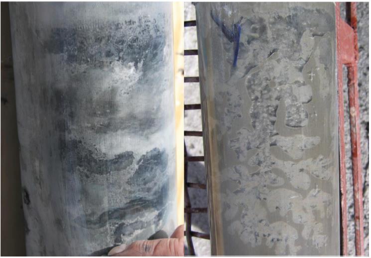
25 Drilling methods Diamond Sonic Brine drilling fluid
26 Physical sample test work Porosity & Permeability Core samples tested for total and effective porosity and specific yield Specific yield how do you actually measure it? Different labs, different methods. Using a centrifuge to simulate free draining of pores Permeability sampling of cores to compare with pump testing Need to consider potential scale factor variation between core and pump tests


27 Porosity testing Well sealed core samples for testing Liquid resaturation effective porosity measurements Helium injection used for effective porosity measurements Specific yield measurements using a low speed centrifuge technique to simulate the effect of pumping
 that is related to Pe and Sy Source: Orocobre, Lithium")
28 Porosity relationships Pt (total porosity) > Pe (effective porosity) > Sy (specific yield) Fine grain lithologies have Sr (specific retention) >> Sy (specific yield), where n = Sy + Sr Neutron logs corrected with caliper data to provide a continuous porosity measure (N-Pt) that is related to Pe and Sy Source: Orocobre, Lithium Americas
29 Hydraulic conductivity, storativity Halite units can have secondary porosity, with overall porosity decreasing with depth due to halite compaction Very high hydraulic conductivities and storativity Clastic units (clay to sand) have much lower hydraulic conductivity and storativity Gypsum sands in Central Australian salt lakes, when wind blown and uncemented, can have significant porosity and storage Aquifer type Lithology K m/d Effective porosity% Specific yield% Storativity Source Unconfined Halite E-02 Rincon Unconfined Halite E-01 Rincon Unconfined Fine clastics, some halite, sand 1-2 < Olaroz Fine clastics, some Confined sand E-3-1.0E-4 Olaroz Confined aquitard Silt/Clay E-06 Olaroz Confined Sand Rodinia Source: Orocobre, Rodinia
30 Brine sampling Sampling of the brine is essential as the lithium is extracted from the brine. Sampling methods include: Bailer sampling during diamond or sonic drilling, when casing is present Pumping from specific intervals with packers, or from screened intervals Brine extraction from core samples, subsampling the interior to prevent contamination from drilling brine Brine near saturation which presents a challenge Analysed for Li, K, B, Ca, Mg, Na, Cl, SO4, HCO3, CO3 and trace elements. Carbonate and bicarbonate low

31 Brine chemistry low Mg/Li key Salar de Atacama is the gold standard salt lake, huge and high grade Uyuni is the true monster, but chemistry is less attractive for conventional processing, as is the project location Silver Peak, Nevada is a long term operation Olaroz came on stream as a producer in 2015 Rincon, Cauchari and Salinas Grandes are all potential new operations Source: Orocobre
32 Salt lake chemical zonation Typical zonation with carbonates deposited around lake margins or beyond the lake, sulphates (gypsum) and a central halite zone. Can be quite asymmetric, depending on the inflows to the basin Source: Houston, 2011
33 Density contrasts Alluvial fans are developed around many salt lakes in active tectonic environments These have thick unsaturated zones away from the lakes & host fresh to brackish water in equilibrium with the lake brine Evaporation from the surface of the lake balances inflows from alluvial fans and river deltas entering the lake basins A gyben-herzberg density interface develops on the margins of the lakes Pumping from the lake sediments is likely to results in changes to the lake hydrogeology and density gradients

34 Density variation - theory Dilution of brine by marginal less concentrated water is a groundwater management issue Source: Lithium Americas
35 How much brine is there? Defining resources is a critical step in determining whether a salt lake has potential for economic production Drilling to determine how deep and what type of sediments are present Porosity and permeability testing of samples Pump testing, to evaluate brine flows Evaluation of brine chemistry can you produce saleable product Evaporation and solar radiation measurements Simulating brine extraction with a groundwater model


36 Extraction & borefield management


37 Groundwater modelling Unconfined to leaky confined layered aquifers Complex model domains with faults how simplified can they be? Dual density fluid how important is density in these layered aquifers? Recharge volumes over the life of extraction? What is the hydraulic connection with alluvial fans and deeper alluvial material around salars? Modelling required to define conversion from resources to reserves and to manage extraction Source: Lithium Americas
38 Conclusions Catchment lithology influences salt lake chemistry Hydrology and water balance influence salt lake development Tectonics are important to produce deep basins, with thick sediments Brine chemistry is important for economic processing Host sediments vary from true aquifers to aquitards Resource definition requires adequate drilling, defining the stratigraphy and applying appropriate porosities Careful groundwater modelling of operating bore fields is required to simulate the long term pumping effects
39 Where to from here? Stable isotope studies on brines and fresh to brackish water in the groundwater system Age dating of brine from different depths Groundwater modelling of pumping scenarios Hydrogeological model completion to define production schedules and for prediction of drawdowns and to assist groundwater and stakeholder management Long term monitoring of bore networks Further drilling to address data gaps
40 Thanks for your attention
Land subsidence due to groundwater withdrawal in Hanoi, Vietnam
 Land Subsidence (Proceedings of the Fifth International Symposium on Land Subsidence, The Hague, October 1995). 1AHS Publ. no. 234, 1995. 55 Land subsidence due to groundwater withdrawal in Hanoi, Vietnam
Interpretation and application of hydrogeological concepts to commercial scale brine extraction projects
 Interpretation and application of hydrogeological concepts to commercial scale brine extraction projects ABSTRACT Terry Braun, Pablo Cortegoso*, Cristian Pereira* and Vladimir Ugorets* 1. SRK Consulting
Lithium Brines: What can we learn from established brine production regions?
 Lithium Brines: What can we learn from established brine production regions? An Overview Of Lithium Brine Exploration for Resource Estimation Camilo de los Hoyos Ph.D, Senior Consultant (Geochemistry &
Finding Large Capacity Groundwater Supplies for Irrigation
 Finding Large Capacity Groundwater Supplies for Irrigation December 14, 2012 Presented by: Michael L. Chapman, Jr., PG Irrigation Well Site Evaluation Background Investigation Identify Hydrogeologic Conditions
Mark S. Nordberg Geology and Groundwater Investigations Section North Central Region Office California Department of Water Resources
 Mark S. Nordberg Geology and Groundwater Investigations Section North Central Region Office California Department of Water Resources Ukiah Drought Workshop July 29, 2009 Groundwater 101 Groundwater is
Sediment and sedimentary rocks Sediment
 Sediment and sedimentary rocks Sediment From sediments to sedimentary rocks (transportation, deposition, preservation and lithification) Types of sedimentary rocks (clastic, chemical and organic) Sedimentary
11/22/2010. Groundwater in Unconsolidated Deposits. Alluvial (fluvial) deposits. - consist of gravel, sand, silt and clay
 deposits. - consist of gravel, sand, silt and clay") Groundwater in Unconsolidated Deposits Alluvial (fluvial) deposits - consist of gravel, sand, silt and clay - laid down by physical processes in rivers and flood plains - major sources for water supplies
Groundwater in Unconsolidated Deposits Alluvial (fluvial) deposits - consist of gravel, sand, silt and clay - laid down by physical processes in rivers and flood plains - major sources for water supplies
Soils, Hydrogeology, and Aquifer Properties. Philip B. Bedient 2006 Rice University
 Soils, Hydrogeology, and Aquifer Properties Philip B. Bedient 2006 Rice University Charbeneau, 2000. Basin Hydrologic Cycle Global Water Supply Distribution 3% of earth s water is fresh - 97% oceans 1%
' International Institute for Land Reclamation and Improvement. 2 Groundwater Investigations. N.A. de Ridder'? 2.1 Introduction. 2.
 2 Groundwater Investigations N.A. de Ridder'? 2.1 Introduction Successful drainage depends largely on a proper diagnosis of the causes of the excess water. For this diagnosis, one must consider: climate,
Prof. Stephen A. Nelson EENS 111. Groundwater
 Page 1 of 8 Prof. Stephen A. Nelson EENS 111 Tulane University Physical Geology This page last updated on 20-Oct-2003 is water that exists in the pore spaces and fractures in rock and sediment beneath
Development of Lithium Brine Projects
 Development of Lithium Brine Projects pcortegoso@srk.com Pablo Cortegoso, M.Eng. - SRK Consulting US Perth, WA - August 16 th, 2016 Lithium Deposits Worldwide Why brines? Why not??? Byproduct potential
Surface Processes Focus on Mass Wasting (Chapter 10)
") Surface Processes Focus on Mass Wasting (Chapter 10) 1. What is the distinction between weathering, mass wasting, and erosion? 2. What is the controlling force in mass wasting? What force provides resistance?
Surface Processes Focus on Mass Wasting (Chapter 10) 1. What is the distinction between weathering, mass wasting, and erosion? 2. What is the controlling force in mass wasting? What force provides resistance?
RIVERS, GROUNDWATER, AND GLACIERS
 RIVERS, GROUNDWATER, AND GLACIERS Delta A fan-shaped deposit that forms when a river flows into a quiet or large body of water, such as a lake, an ocean, or an inland sea. Alluvial Fan A sloping triangle
Pre-Lab Reading Questions ES202
 ES202 The are designed to encourage students to read lab material prior to attending class during any given week. Reading the weekly lab prior to attending class will result in better grade performance
For personal use only
 ASX RELEASE LPI.ASX 22 December 2016 STRONG LITHIUM BRINE FLOW RATE FOR MARICUNGA PUMP TEST Pump test has commenced at well P4 located within the Cocina tenement, adjacent to the high-grade M10 drill hole
Evolution of the conceptual hydrogeologic and ground-water flow model for Las Vegas Valley, Clark County, Nevada
 Evolution of the conceptual hydrogeologic and ground-water flow model for Las Vegas Valley, Clark County, Nevada Geological Society of America Annual Meeting November 14, 2 David J. Donovan Southern Nevada
Orocobre Announces Maiden Resource at the Cauchari Lithium- Potash Project
 ASX/TSX ANNOUNCEMENT Orocobre Announces Maiden Resource at the Cauchari Lithium- Potash Project 22 October 2012 Highlights An inferred resource has been estimated containing approximately 470,000 tonnes
AMERICAN POTASH LITHIUM BRINE PROJECT: Paradox Basin, UT and CO. May 26, 2017 CSE: AMP
 AMERICAN POTASH LITHIUM BRINE PROJECT: Paradox Basin, UT and CO May 26, 2017 CSE: AMP 1 AMERICAN POTASH IN THE PARADOX BASIN AMP are currently operating two exploration and development programs in the
Chapter 6 Pages of Earth s Past: Sedimentary Rocks
 Chapter 6 Pages of Earth s Past: Sedimentary Rocks Introduction! Drilling into the bottom of the North Sea, we encounter: " Soft mud and loose sand, silt, pebbles, and shells. Then: " Similar materials
Sedimentary Rocks. Origin, Properties and Identification. Physical Geology GEOL 101 Lab Ray Rector - Instructor
 Sedimentary Rocks Origin, Properties and Identification Physical Geology GEOL 101 Lab Ray Rector - Instructor Sedimentary Rock Origin and Identification Lab Pre-Lab Internet Link Resources 1) http://www.rockhounds.com/rockshop/rockkey/index.html
Chapter 8 Fetter, Applied Hydrology 4 th Edition, Geology of Groundwater Occurrence
 Chapter 8 Fetter, Applied Hydrology 4 th Edition, 2001 Geology of Groundwater Occurrence Figure 8.42. Alluvial Valleys ground-water region. Fetter, Applied Hydrology 4 th Edition, 2001 Fetter, Applied
Lab 7: Sedimentary Structures
 Name: Lab 7: Sedimentary Structures Sedimentary rocks account for a negligibly small fraction of Earth s mass, yet they are commonly encountered because the processes that form them are ubiquitous in the
SASKATCHEWAN STRATIGRAPHY GLACIAL EXAMPLE BOULDERS IN GLACIAL DEPOSITS
 SASKATCHEWAN STRATIGRAPHY GLACIAL EXAMPLE BOULDERS IN GLACIAL DEPOSITS 51 SASKATCHEWAN STRATIGRAPHY GLACIAL SURFICIAL STRATIFIED DEPOSITS 52 SASKATCHEWAN STRATIGRAPHY GLACIAL EXAMPLE OF SEDIMENT DEPOSITION
Sedimentary Rocks. Origin, Properties and Identification. Geology Laboratory GEOL 101 Lab Ray Rector - Instructor
 Sedimentary Rocks Origin, Properties and Identification Geology Laboratory GEOL 101 Lab Ray Rector - Instructor Sedimentary Rock Origin and Identification Lab Pre-Lab Internet Link Resources 1) http://www.rockhounds.com/rockshop/rockkey/index.html
Essentials of Geology, 11e
 Essentials of Geology, 11e Groundwater Chapter 10 Instructor Jennifer Barson Spokane Falls Community College Geology 101 Stanley Hatfield Southwestern Illinois Co Jennifer Cole Northeastern University
Section I: Multiple Choice Select the best answer to each question. Mark your final answer on the answer sheet. (1 pt each)
") Sedimentary Rocks & Surface Processes Quest Name: Earth Science 2013 Block: Date: Section I: Multiple Choice Select the best answer to each question. Mark your final answer on the answer sheet. (1 pt each)
Sedimentary Rocks & Surface Processes Quest Name: Earth Science 2013 Block: Date: Section I: Multiple Choice Select the best answer to each question. Mark your final answer on the answer sheet. (1 pt each)
DATA ACQUISITION METHODS FOR GROUNDWATER INVESTIGATION AND THE SITING OF WATER SUPPLY WELLS
 DATA ACQUISITION METHODS FOR GROUNDWATER INVESTIGATION AND THE SITING OF WATER SUPPLY WELLS M.B.J. Foster Tetra Tech EM Inc., San Francisco, CA, USA Keywords: Groundwater, water wells, drilled wells, geophysical
Dr. N.W. B. Balasooriya
 ESM 31031 HYDROGEOLOGY Dr. N.W. B. Balasooriya 1 1 Hydrogeology Hydrogeology is defined as the science which treats the occurrence, distribution and movement of water below the Earth surface. 2 Groundwater
Surface Water and Stream Development
 Surface Water and Stream Development Surface Water The moment a raindrop falls to earth it begins its return to the sea. Once water reaches Earth s surface it may evaporate back into the atmosphere, soak
Which map shows the stream drainage pattern that most likely formed on the surface of this volcano? A) B)
 B)") 1. When snow cover on the land melts, the water will most likely become surface runoff if the land surface is A) frozen B) porous C) grass covered D) unconsolidated gravel Base your answers to questions
1. When snow cover on the land melts, the water will most likely become surface runoff if the land surface is A) frozen B) porous C) grass covered D) unconsolidated gravel Base your answers to questions
1 Water Beneath the Surface
 CHAPTER 16 1 Water Beneath the Surface SECTION Groundwater KEY IDEAS As you read this section, keep these questions in mind: What are two properties of aquifers? How is the water table related to the land
Karst found mostly in limestone (rock with at least 50% carbonate minerals), depends on 1) permeability & porosity
, depends on 1) permeability & porosity") KARST LANDFORMS produced by weathering & erosion in regions of carbonate rocks and evaporites processes called karstification mainly below ground surface predominantly underground drainage poorly-developed
KARST LANDFORMS produced by weathering & erosion in regions of carbonate rocks and evaporites processes called karstification mainly below ground surface predominantly underground drainage poorly-developed
 12 10 8 6 4 2 0 40-50 50-60 60-70 70-80 80-90 90-100 Fresh Water What we will cover The Hydrologic Cycle River systems Floods Groundwater Caves and Karst Topography Hot springs Distribution of water in
Depositional Environments. Depositional Environments
 Depositional Environments Geographic area in which sediment is deposited Characterized by a combination of geological process & environmental conditions Depositional Environments Geological processes:
ESC102. Sedimentary Rocks. Our keys to the past. Monday, February 11, 13
 ESC102 Sedimentary Rocks Our keys to the past Sedimentary Rocks Sedimentary rocks are rocks that form through the accumulation of sediment and the process of lithification. Lithification occurs after deposition
HYDROGEOLOGICAL PROPERTIES OF THE UG2 PYROXENITE AQUIFERS OF THE BUSHVELD COMPLEX
 R. Gebrekristos, P.Cheshire HYDROGEOLOGICAL PROPERTIES OF THE UG2 PYROXENITE AQUIFERS OF THE BUSHVELD COMPLEX R. Gebrekristos Digby Wells Environmental P. Cheshire Groundwater Monitoring Services Abstract
Sedimentary Rocks. Origin, Properties and Identification. Physical Geology GEOL 100. Ray Rector - Instructor
 Sedimentary Rocks Origin, Properties and Identification Physical Geology GEOL 100 Ray Rector - Instructor Sedimentary Rock Origin and Identification Lab Pre-Lab Internet Link Resources 1) http://www.rockhounds.com/rockshop/rockkey/index.html
Groundwater. (x 1000 km 3 /y) Oceans Cover >70% of Surface. Groundwater and the. Hydrologic Cycle
 Oceans Cover >70% of Surface. Groundwater and the. Hydrologic Cycle") Chapter 17 Oceans Cover >70% of Surface Groundwater and the Hydrologic Cycle Vasey s Paradise, GCNP Oceans are only 0.025% of Mass Groundwater Groundwater is liquid water that lies in the subsurface in
Chapter 17 Oceans Cover >70% of Surface Groundwater and the Hydrologic Cycle Vasey s Paradise, GCNP Oceans are only 0.025% of Mass Groundwater Groundwater is liquid water that lies in the subsurface in
For personal use only
 ASX RELEASE LPI:ASX - 12 July 2017 MARICUNGA LITHIUM BRINE PROJECT 3.7 FOLD INCREASE IN MINERAL RESOURCE ESTIMATE Highlights Major 3.7 fold increase of high grade Measured, Indicated and Inferred resource
Groundwater Hydrology
 EXERCISE 12 Groundwater Hydrology INTRODUCTION Groundwater is an important component of the hydrologic cycle. It feeds lakes, rivers, wetlands, and reservoirs; it supplies water for domestic, municipal,
For personal use only
 thium Power International Ltd Level 7, 151 Macquarie Street Sydney NSW 2000 Australia lithiumpowerinternational.com 28 July 2017 ACN 607 260 328 Activity Report for the Quarter ended June 2017 thium Power
Physical Geology, 15/e
 Lecture Outlines Physical Geology, 15/e Plummer, Carlson & Hammersley Deserts & Wind Action Physical Geology 15/e, Chapter 13 Deserts Desert any arid region that receives less than 25 cm of precipitation
Chapter 6 Sedimentary and Metamorphic Rock
 Chapter 6 Sedimentary and Metamorphic Rock Weathering and Erosion Wherever rock is exposed at Earth s surface, it is continuously being broken down by weathering a set of physical and chemical processes
Sediment and Sedimentary rock
 Sediment and Sedimentary rock Sediment: An accumulation of loose mineral grains, such as boulders, pebbles, sand, silt or mud, which are not cemented together. Mechanical and chemical weathering produces
Lecture Outline Wednesday - Friday February 14-16, 2018
 Lecture Outline Wednesday - Friday February 14-16, 2018 Quiz 2 scheduled for Friday Feb 23 (Interlude B, Chapters 6,7) Questions? Chapter 6 Pages of the Past: Sedimentary Rocks Key Points for today Be
Hydrogeology of the San Agustin Plains
 Hydrogeology of the San Agustin Plains Alex Rinehart, Daniel Koning and Stacy Timmons New Mexico Bureau of Geology New Mexico Tech 16 August 2017 62nd New Mexico Water Conference Acknowledgments Community
A. IGNEOUS Rocks formed by cooling and hardening of hot molten rock called magma (within crust or at its surface).
.") EARTH SCIENCE 11 CHAPTER 5 NOTES KEY How Earth's Rocks Were Formed Early geologists believed that the physical features of the Earth were formed by sudden spectacular events called CATASTROPHES. Modern
EARTH SCIENCE 11 CHAPTER 5 NOTES KEY How Earth's Rocks Were Formed Early geologists believed that the physical features of the Earth were formed by sudden spectacular events called CATASTROPHES. Modern
Module 9 Sedimentary Rocks
 Module 9 Sedimentary Rocks SEDIMENTARY ROCKS Rocks formed from material derived from preexisting rocks by surfacial processes followed by diagenesis There are two main classes of sedimentary rocks Clastic
VERY HIGH LITHIUM BRINE FLOW RATES FROM NEAR SURFACE SALT UNIT AT MARICUNGA, CHILE
 ASX RELEASE LPI.ASX 18 May 2017 VERY HIGH LITHIUM BRINE FLOW RATES FROM NEAR SURFACE SALT UNIT AT MARICUNGA, CHILE A pump test was completed on the upper 16 m of well P2 in the south of the Litio tenement,
3. The map below shows an eastern portion of North America. Points A and B represent locations on the eastern shoreline.
 1. Most tornadoes in the Northern Hemisphere are best described as violently rotating columns of air surrounded by A) clockwise surface winds moving toward the columns B) clockwise surface winds moving
1. are most likely to study the images sent back from Mars. A. Astronomers B. Geologists C. Doctors D. Engineers
 1. are most likely to study the images sent back from Mars. A. Astronomers B. Geologists C. Doctors D. Engineers 2. When did the Earth form? A. About 540 million years ago B. About 2.5 billion years ago
GEOL Introductory Geology: Exploring Planet Earth Fall 2010 Test #2 October 18, 2010
 GEOL 101 - Introductory Geology: Exploring Planet Earth Fall 2010 Test #2 October 18, 2010 Name KEY ID# KEY Multiple choice questions (2 points each). 1. What type of metamorphic rock is formed over large
Chapter 13. Groundwater
 Chapter 13 Groundwater Introduction Groundwater is all subsurface water that completely fills the pores and other open spaces in rocks, sediments, and soil. Groundwater is responsible for forming beautiful
When last we left off. Western Cordillera NA. Cretaceous. Cretaceous, continued. Cretaceous to present
 When last we left off Western Cordillera NA Cretaceous to present Wild and weird things happened in the murky past of the Archean and precambrian Cambrian through Devonian development of deep water sediments
resource and vulnerability Robineau & Join, nov
 Groundwater in tropical islands resource and vulnerability Robineau & Join, nov 2007 1 Diversity of hydrogeological environments in coastal areas of tropical islands : Hydrologic conditions (surface waters)
EROSION, DEPOSITION AND SEDIMENTARY ROCKS. Reading: Earth Science Tarbuck and Lutgens Chapter 5: pages Chapter 3: pages 52-54, 61-69
 EROSION, DEPOSITION AND SEDIMENTARY ROCKS Reading: Earth Science Tarbuck and Lutgens Chapter 5: pages 124-133 Chapter 3: pages 52-54, 61-69 Base Level Resistant bed Resistant bed creates a local base level
A. V T = 1 B. Ms = 1 C. Vs = 1 D. Vv = 1
 Geology and Soil Mechanics 55401 /1A (2002-2003) Mark the best answer on the multiple choice answer sheet. 1. Soil mechanics is the application of hydraulics, geology and mechanics to problems relating
For personal use only
 24 November 2016 ASX/TSX Announcement Orocobre Partners with Advantage Lithium Technical Details of Cauchari Flagship Lithium Asset Highlights The Cauchari project lies between Orocobre s producing Olaroz
Laboratory Exercise #4 Geologic Surface Processes in Dry Lands
 Page - 1 Laboratory Exercise #4 Geologic Surface Processes in Dry Lands Section A Overview of Lands with Dry Climates The definition of a dry climate is tied to an understanding of the hydrologic cycle
Physical Geography A Living Planet
 Physical Geography A Living Planet The geography and structure of the earth are continually being changed by internal forces, like plate tectonics, and external forces, like the weather. Iguaçu Falls at
Chapter 14: Groundwater. Fig 14.5b
 Chapter 14: Groundwater Fig 14.5b OBJECTIVES Recognize that groundwater is a vital source of accessible freshwater. Describe how groundwater forms below the water table. Explain the origin of aquifers,
For personal use only
 ASX Market Announcements Office 14 June 2018 LAKE RESOURCES N.L. (ASX:LKE) FURTHER DRILLING REINFORCES CONFIDENCE IN SCALE OF SIGNIFICANT LITHIUM BRINE DISCOVERY- KACHI LITHIUM PROJECT Initial drilling
Lab 9: Petroleum and groundwater
 Geology 101 Name(s): Lab 9: Petroleum and groundwater Petroleum (oil) is a multi-component liquid refined to generate different hydrocarbons, such as heptane (a component of gasoline) and waxes. For the
Lecture 15: Subsidence
 Lecture 15: Subsidence Key Questions 1. How does removal of groundwater cause subsidence on a regional scale? 2. Under what conditions does a building sink into sediment? 3. Why do clays consolidate more
NC Earth Science Essential Standards
 NC Earth Science Essential Standards EEn. 2.1 Explain how processes and forces affect the Lithosphere. EEn. 2.1.1 Explain how the rock cycle, plate tectonics, volcanoes, and earthquakes impact the Lithosphere.
Coso Red Hill and Coso Playa field trip, Prof. Alessandro Grippo, Ph.D.
 HISTORICAL GEOLOGY fall 2016 Professor: Dr. Alessandro Grippo, Ph.D. FIELD TRIP REPORT: Friday, October 21, 2016: Coso Red Hill & Playa, Coso Junction CA YOUR NAME part 1: COSO RED HILL (you can sample
Groundwater. (x 1000 km 3 /y) Reservoirs. Oceans Cover >70% of Surface. Groundwater and the. Hydrologic Cycle
 Reservoirs. Oceans Cover >70% of Surface. Groundwater and the. Hydrologic Cycle") Chapter 13 Oceans Cover >70% of Surface Groundwater and the Hydrologic Cycle Oceans are only 0.025% of Mass Groundwater Groundwater is liquid water that lies in the subsurface in fractures in rocks and
Chapter 13 Oceans Cover >70% of Surface Groundwater and the Hydrologic Cycle Oceans are only 0.025% of Mass Groundwater Groundwater is liquid water that lies in the subsurface in fractures in rocks and
What do you need for a Marathon?
 What do you need for a Marathon? Water and a snack? What about just a normal day? 1 flush = 3.5 gallons 1 flush = 3.5 gallons 10 minute shower = 20 gal 1 flush = 3.5 gallons 10 minute shower = 20 gal Jeans
GY 111 Lecture Note Series Sedimentary Environments 2: Rivers and Deltas
 GY 111 Lecture Notes D. Haywick (2008-09) 1 GY 111 Lecture Note Series Sedimentary Environments 2: Rivers and Deltas Lecture Goals A) Rivers and Deltas (types) B) Water Flow and sedimentation in river/deltas
Geology and Soil Mechanics /1A ( ) Mark the best answer on the multiple choice answer sheet.
 Mark the best answer on the multiple choice answer sheet.") Geology and Soil Mechanics 55401 /1A (2003-2004) Mark the best answer on the multiple choice answer sheet. 1. Soil mechanics is the application of hydraulics, geology and mechanics to problems relating
Geology and Soil Mechanics 55401 /1A (2003-2004) Mark the best answer on the multiple choice answer sheet. 1. Soil mechanics is the application of hydraulics, geology and mechanics to problems relating
Prentice Hall EARTH SCIENCE
 Prentice Hall EARTH SCIENCE Tarbuck Lutgens Chapter 7 Glaciers, Desert, and Wind 7.1 Glaciers Types of Glaciers A glacier is a thick ice mass that forms above the snowline over hundreds or thousands of
Objectives. Introduction to Soils. Terms to know: What is soil? Study of Soils. The Soil Body 11/9/2012
 Objectives Explain what soil is and where it comes from Define a soil body List examples of the five soil-forming factors Explain how soils develop Introduction to Soils Terms to know: What is soil? Alluvial
Aquitard Characterization The Legend of Indiana s Magic Clay Layer. Juliet Port, LPG #2214 July 2014
 Aquitard Characterization The Legend of Indiana s Magic Clay Layer Juliet Port, LPG #2214 July 2014 Topics What is an Aquitard? Why do we care? Review of Indiana glacial geology Conceptual Framework Investigation
What we will cover. The Hydrologic Cycle. River systems. Floods. Groundwater. Caves and Karst Topography. Hot springs
 Fresh Water What we will cover The Hydrologic Cycle River systems Floods Groundwater Caves and Karst Topography Hot springs On a piece of paper, put these reservoirs of water in to order from largest to
UNIT 4 SEDIMENTARY ROCKS
 UNIT 4 SEDIMENTARY ROCKS WHAT ARE SEDIMENTS Sediments are loose Earth materials (unconsolidated materials) such as sand which are transported by the action of water, wind, glacial ice and gravity. These
What is a water table? What is an aquifer? What is the difference between a spring and a well?
 CHAPTER 11 3 Water Underground SECTION The Flow of Fresh Water BEFORE YOU READ After you read this section, you should be able to answer these questions: What is a water table? What is an aquifer? What
Fresh Water: Streams, Lakes Groundwater & Wetlands
 Fresh Water:, Lakes Groundwater & Wetlands Oct 27 Glaciers and Ice Ages Chp 13 Nov 3 Deserts and Wind and EXAM #3 Slope hydrologic cycle P = precip I = precip intercepted by veg ET = evapotranspiration
every continent has an extensive dry region! " deserts are as much as 1/3 of Earth s surface!
 deserts! deserts! every continent has an extensive dry region! " deserts are as much as 1/3 of Earth s surface! Hollywood portrayal of vast stretches of sand dune! " Sahara has only 10% covered by sand!
Understanding Earth Fifth Edition
 Understanding Earth Fifth Edition Grotzinger Jordan Press Siever Chapter 5: SEDIMENTATION: Rocks Formed by Surface Processes Lecturer: H Mohammadzadeh Assistant professors, Department of Geology, FUM Copyright
DRILLING CONFIRMS LARGE SCALE LITHIUM BRINE BASIN KACHI LITHIUM PROJECT, ARGENTINA
 ASX Market Announcements Office 22 May 2018 LAKE RESOURCES N.L. (ASX:LKE) DRILLING CONFIRMS LARGE SCALE LITHIUM BRINE BASIN KACHI LITHIUM PROJECT, ARGENTINA Initial drilling confirms the Kachi Lithium
ASX / TSX ANNOUNCEMENT
 ASX / TSX ANNOUNCEMENT 7 February 2018 CAUCHARI HOLE CAU11 PUMPING AT 19L/S AT 515 MG/L LITHIUM Orocobre Limited (ASX: ORE, TSX: ORL ) ( Orocobre or the Company ) is pleased to provide an update on the
ASX / TSX ANNOUNCEMENT
 ASX / TSX ANNOUNCEMENT 10 January 2019 Cauchari Drilling Update Phase III Drilling Complete Orocobre Limited (ASX: ORE, TSX: ORL) ( Orocobre or the Company ) provides the following update on the completion
12. The diagram below shows the collision of an oceanic plate and a continental plate.
 Review 1. Base your answer to the following question on the cross section below, which shows the boundary between two lithospheric plates. Point X is a location in the continental lithosphere. The depth
Sedimentary Rocks. Weathering. Mechanical & Chemical Weathering. Sediments. Lithification. Deposition. Transport. Erosion.
 Lithification Sedimentary Rocks Sediments Deposition Transport Erosion Weathering Weathering The sediments that make up sedimentary rocks are produced by: Mechanical & Chemical Weathering Mechanical Weathering
Chapter 10. Chapter Rocks and the Rock Cycle. Rocks. Section 1 Rocks and the Rock Cycle
 Chapter 10 Rocks 1 Chapter 10 Section 1 Rocks and the Rock Cycle 2 10.1 Rocks and the Rock Cycle Magma is the parent material for all rocks. Once the magma cools and hardens, many changes can occur. Geology:
Erosion Surface Water. moving, transporting, and depositing sediment.
 + Erosion Surface Water moving, transporting, and depositing sediment. + Surface Water 2 Water from rainfall can hit Earth s surface and do a number of things: Slowly soak into the ground: Infiltration
WATER ON AND UNDER GROUND. Objectives. The Hydrologic Cycle
 WATER ON AND UNDER GROUND Objectives Define and describe the hydrologic cycle. Identify the basic characteristics of streams. Define drainage basin. Describe how floods occur and what factors may make
Rocks Rock- A group of minerals, glass, mineroid bound together in some way.
 Rocks Rock- A group of minerals, glass, mineroid bound together in some way. All rocks fit into one of three categories: Igneous- formed by the cooling and hardening of hot molten rock Sedimentary- formed
Geophysical Surveys for Groundwater Modelling of Coastal Golf Courses
 1 Geophysical Surveys for Groundwater Modelling of Coastal Golf Courses C. RICHARD BATES and RUTH ROBINSON Sedimentary Systems Research Group, University of St. Andrews, St. Andrews, Scotland Abstract
GEOLOGY CURRICULUM. Unit 1: Introduction to Geology
 Chariho Regional School District - Science Curriculum September, 2016 GEOLOGY CURRICULUM Unit 1: Introduction to Geology OVERVIEW Summary In this unit students will be introduced to the field of geology.
Appendix G. Summary of Hydrogeologic Conditions and Historical Mining Northwest of the Centro Subarea in the Randsburg, Red Mountain, and Atolia Area
 Appendix G Summary of Hydrogeologic Conditions and Historical Mining Northwest of the Centro Subarea in the Randsburg, Red Mountain, and Atolia Area 1.1 Background This appendix provides a summary of hydrogeologic
Minerals and Rocks Chapter 20
 Minerals and Rocks Chapter 20 Emily and Megan Earth System Science Interconnected Rocks and minerals Interior processes Erosion and deposition Water and air Elements of Earth by weight Made of atoms Earth
6.1 Water. The Water Cycle
 6.1 Water The Water Cycle Water constantly moves among the oceans, the atmosphere, the solid Earth, and the biosphere. This unending circulation of Earth s water supply is the water cycle. The Water Cycle
GEOLOGY MEDIA SUITE Chapter 5
 UNDERSTANDING EARTH, SIXTH EDITION GROTZINGER JORDAN GEOLOGY MEDIA SUITE Chapter 5 Sedimentation Rocks Formed by Surface Processes 2010 W.H. Freeman and Company Mineralogy of sandstones Key Figure 5.12
For personal use only
 ASX RELEASE LPI.ASX 24 October 2016 DRILLING UPDATE MARICUNGA LITHIUM BRINE PROJECT IN CHILE Drilling program continues at Maricunga lithium brine project, following successful completion of first exploration
DRILLING ADVANCES WITH CONSISTENT RESULTS AT MAJOR DISCOVERY- KACHI LITHIUM PROJECT
 ASX Market Announcements Office 9 August 2018 LAKE RESOURCES N.L. (ASX:LKE) DRILLING ADVANCES WITH CONSISTENT RESULTS AT MAJOR DISCOVERY- KACHI LITHIUM PROJECT Drilling continues to confirm the large scale
Michigan s Geology and Groundwater
 Michigan s Geology and Groundwater Ralph J. Haefner Deputy Director U.S. Geological Survey Michigan-Ohio Water Science Center Lansing, Michigan Outline About the USGS Geology 101 Michigan s geology Bedrock
Streams. Water. Hydrologic Cycle. Geol 104: Streams
 Streams Why study streams? Running water is the most important geologic agent in erosion, transportation and deposition of sediments. Water The unique physical and chemical properties of water make it
Earth Science Chapter 9. Day 6 - Finish Capillary Action Lab - Quiz over Notes - Review Worksheets over Sections 9.2 and 9.3
 Earth Science Chapter 9 Day 1 Day 2 Day 3 Read Section 9.1 Surface Water Chapter 9 Term Sheet Notes over Section 9.1 Surface Water Section 9.1 Review Worksheets Quiz over Section 9.1 Notes Virtual Lab